
Comparative Study of the Subsurface Thermal Structure in Northern Honshu, Japan, Based on Normalized Temperature Data and Solute Geothermometers

Abstract
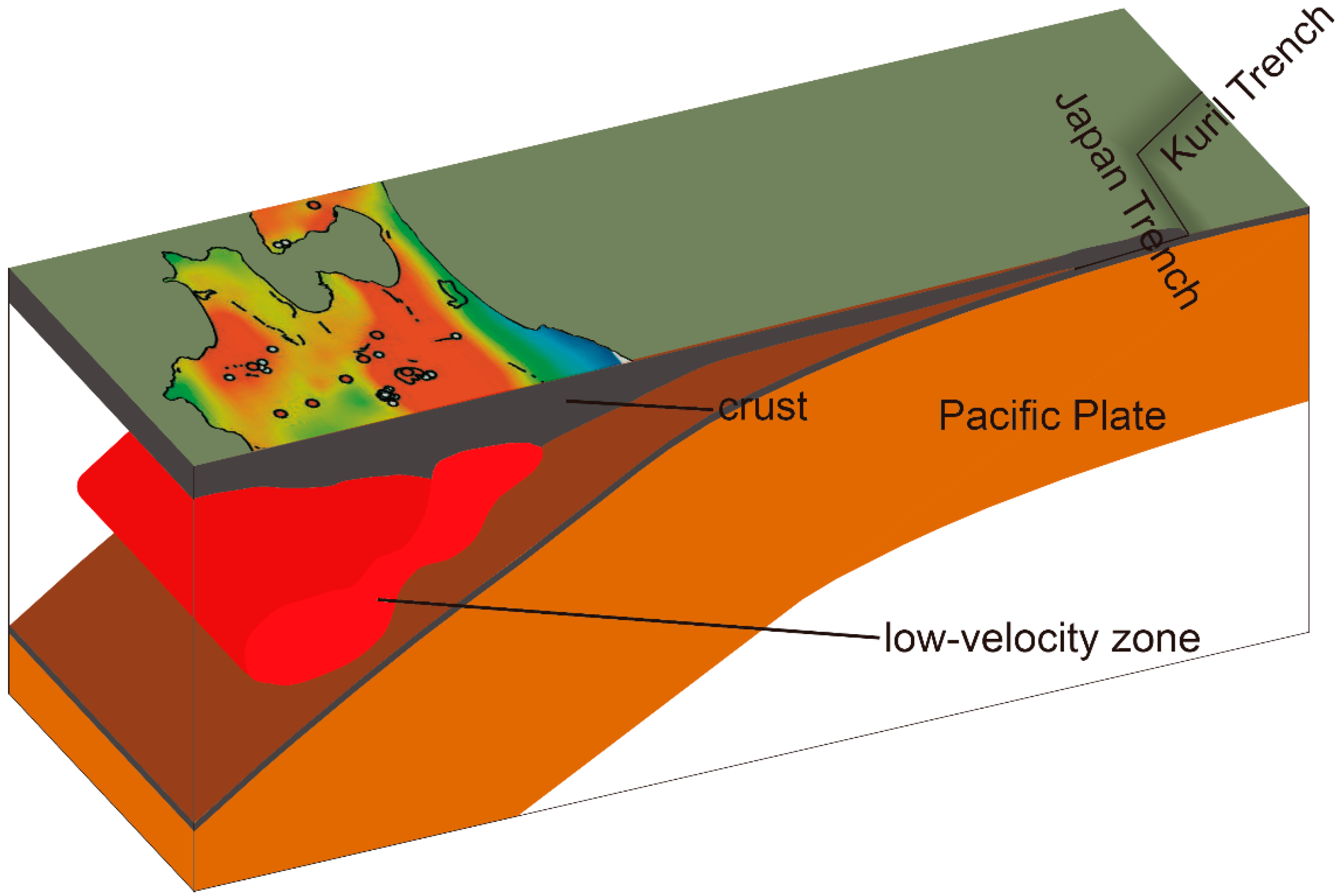
:1. Introduction
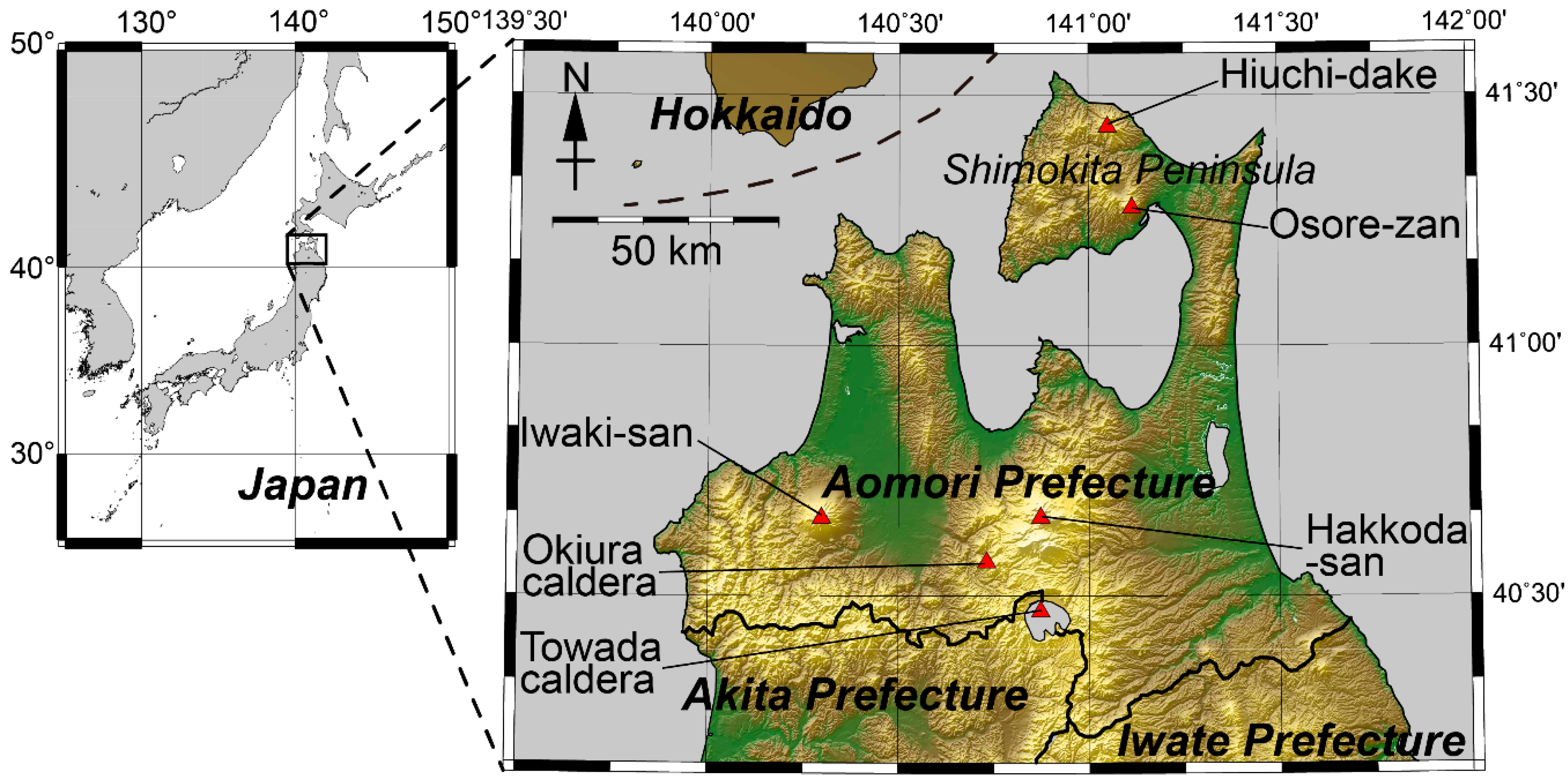
2. Geothermal Resource Database of Aomori Prefecture
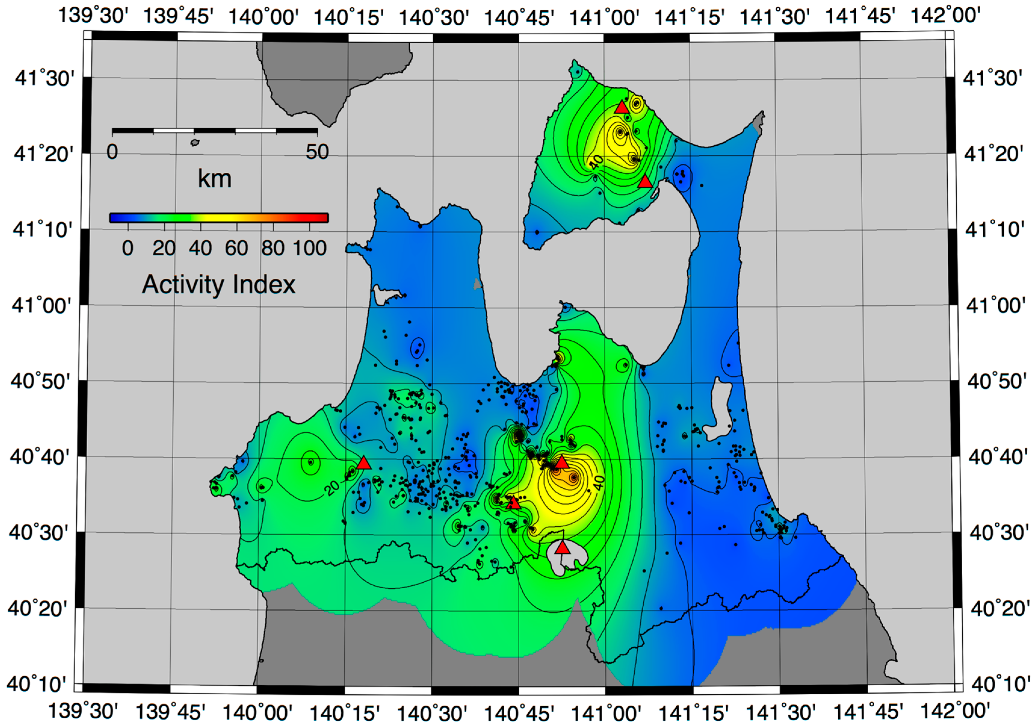
3. Subsurface Thermal Structure Based on the Activity Index
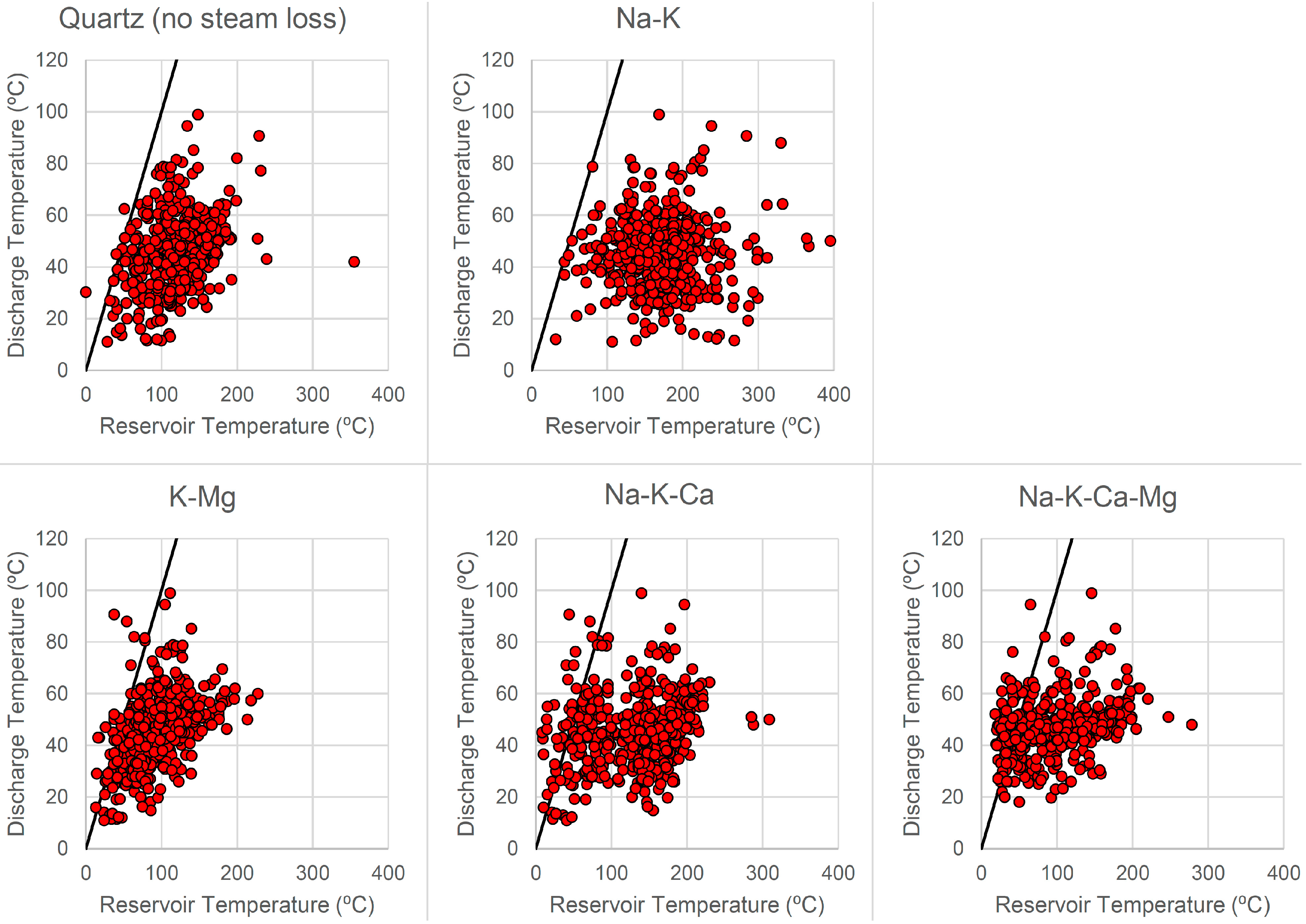
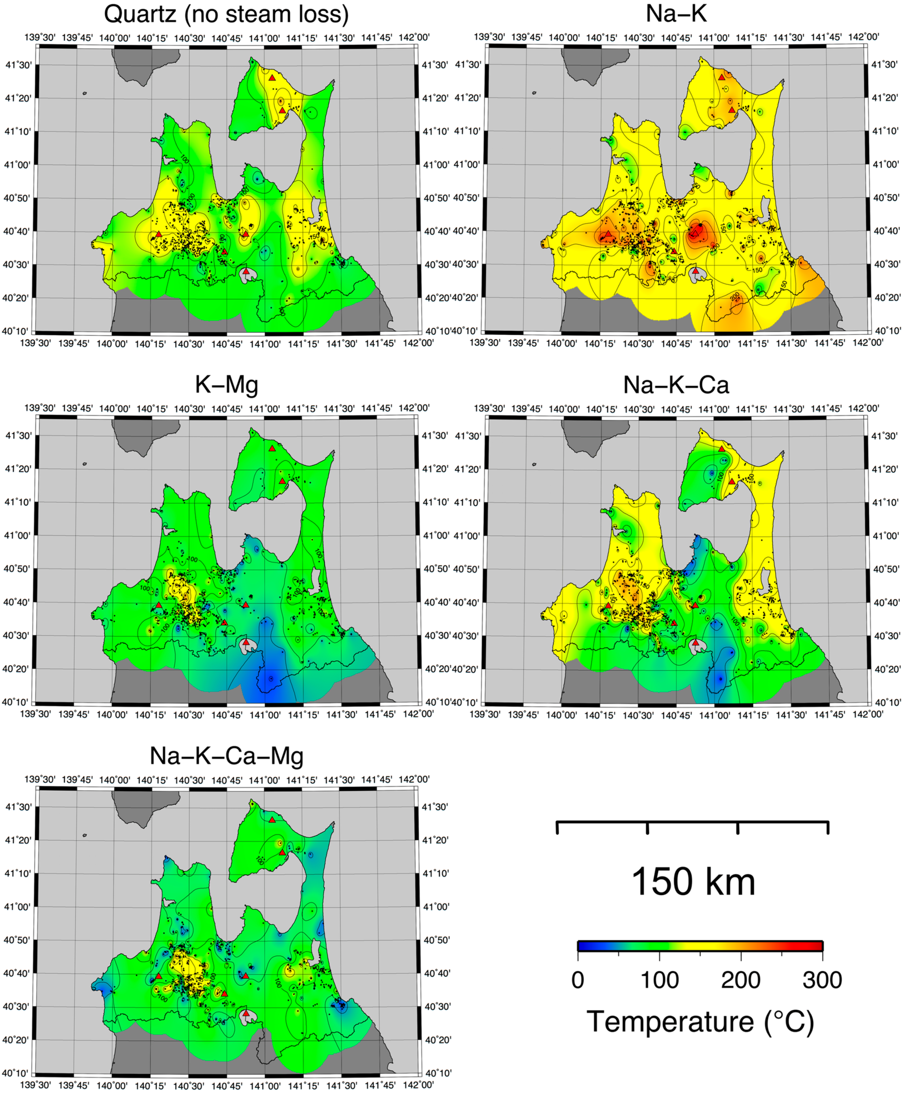
4. Subsurface Thermal Structure Based on Solute Geothermometers
5. Discussion
5.1. Reliability of Solute Geothermometers
5.2. Reliability of the Activity Index Map
5.3. Comparisons between the Activity Index and Solute Geothermometers
6. Conclusions
Acknowledgments
Author Contributions
Conflicts of Interest
References
- Bertani, R. Geothermal power generation in the world 2010–2014 update report. Geothermics 2016, 60, 31–43. [Google Scholar] [CrossRef]
- Muraoka, H. Summary of the heat source distribution investigation. In Trend and Development Technology of Geothermal Power; Science and Technology: Tokyo, Japan, 2011; pp. 125–137. (In Japanese) [Google Scholar]
- Current Situation and Trend of Geothermal Power 2014; Thermal and Nuclear Power Engineering Society: Tokyo, Japan, 2015. (In Japanese)
- Ministry of the Environment, Japan. The State of Use of Hot Springs in Japan in the Fiscal Year 2012. Available online: http://www.env.go.jp/nature/onsen/data/riyo_h24_1.pdf (accessed on 26 February 2016). (In Japanese)
- Geothermal Development Research Document, Shimokita Region; New Energy and Industrial Technology Development Organization Report 9; New Energy and Industrial Technology Development Organization (NEDO): Kawasaki, Japan, 1985. (In Japanese)
- Geothermal Development Research Document, Western Part of Hakkoda Region; New Energy and Industrial Technology Development Organization Report 30; New Energy and Industrial Technology Development Organization (NEDO): Kawasaki, Japan, 1993. (In Japanese)
- Geothermal Development Research Document, Shimoyu Region (Part 1); New Energy and Industrial Technology Development Organization Report C-2-12; New Energy and Industrial Technology Development Organization (NEDO): Kawasaki, Japan, 2009. (In Japanese)
- Geothermal Development Research Document, Shimoyu Region (Part 2); New Energy and Industrial Technology Development Organization Report C-2-12; New Energy and Industrial Technology Development Organization (NEDO): Kawasaki, Japan, 2010. (In Japanese)
- Hayashi, M.; Taguchi, S.; Yamasaki, T. Activity index and thermal history of geothermal systems. Geotherm. Resour. Counc. Trans. 1981, 5, 177–180. [Google Scholar]
- Suzuki, Y.; Ioka, S.; Muraoka, H. Determining the maximum depth of hydrothermal circulation using geothermal mapping and seismicity to delineate the depth to brittle-plastic transition in northern Honshu, Japan. Energies 2014, 7, 3503–3511. [Google Scholar] [CrossRef]
- Muraoka, H.; Sakaguchi, K.; Tamanyu, S.; Sasaki, M.; Shigeno, H.; Mizugaki, K. Atlas of Hydrothermal Systems in Japan; Geological Survey of Japan, the National Institute of Advanced Industrial Science and Technology (AIST): Tsukuba, Japan, 2007. (In Japanese)
- Record of Hot Spring Geology in Aomori Prefecture; Department of Health and Welfare, Aomori Prefectural Office: Aomori, Japan, 1997. (In Japanese)
- Geothermal Potential Map in Japan; Digital Geoscience Map GT-4 (CD-ROM); Geological Survey of Japan, the National Institute of Advanced Industrial Science and Technology (AIST): Tsukuba, Japan, 2009. (In Japanese)
- Koga, A.; Hayashi, M. Chemical characteristics of thermal fluids with high geothermal activity index; Part 1. J. Hot Spring Sci. 1986, 37, 14–19. (In Japanese) [Google Scholar]
- Hayashi, M. The target for exploration of deep high-temperature geothermal reservoirs. J. Geotherm. Res. Soc. Jpn. 1982, 4, 81–90. (In Japanese) [Google Scholar]
- Haas, J.L. The effect of salinity on the maximum thermal gradient of a hydrothermal system at hydrostatic pressure. Econ. Geol. 1971, 66, 940–946. [Google Scholar] [CrossRef]
- Wessel, P.; Smith, W.H.F. New, improved version of the generic mapping tools released. Eos Trans. Am. Geophys. Union 1998, 79, 579. [Google Scholar] [CrossRef]
- Fournier, R.O. Chemical geothermometers and mixing models for geothermal systems. Geothermics 1977, 5, 41–50. [Google Scholar] [CrossRef]
- Giggenbach, W.F. Geothermal solute equilibria. Derivation of Na-K-Mg-Ca geoindicators. Geochim. Cosmochim. Acta 1988, 52, 2749–2765. [Google Scholar] [CrossRef]
- Fournier, R.O.; Truesdell, A.H. An empirical Na-K-Ca geothermometer for natural waters. Geochim. Cosmochim. Acta 1973, 37, 1255–1275. [Google Scholar] [CrossRef]
- Fournier, R.O.; Potter, R.W. Magnesium correction to the Na-K-Ca chemical geothermometer. Geochim. Cosmochim. Acta 1979, 43, 1543–1550. [Google Scholar] [CrossRef]
- Nakajima, J.; Matsuzawa, T.; Hasegawa, A.; Zhao, D. Three-dimensional structure of Vp, Vs, and Vp/Vs beneath northeastern Japan: Implications for arc magmatism and fluids. J. Geophys. Res. 2001, 106, 21843–21857. [Google Scholar] [CrossRef]
- Hasegawa, A.; Nakajima, J.; Kita, S.; Tsuji, Y.; Nii, K.; Okada, T.; Matsuzawa, T.; Zhao, D. Transportation of H2O in the NE Japan Subduction Zone as Inferred from Seismic Observations: Supply of H2O from the Slab to the Arc Crust. J. Geogr. 2008, 117, 59–75. (In Japanese) [Google Scholar] [CrossRef]


| Geothermometer | Equations | References |
|---|---|---|
| Quartz (no steam loss) (concentrations in mg/kg) | Fournier, 1977 [18] | |
| Na-K (concentrations in mg/kg) | Giggenbach, 1988 [19] | |
| K-Mg (concentrations in mg/kg) | Giggenbach, 1988 [19] | |
| Na-K-Ca (concentrations in mol/kg) | Fournier and Truesdell, 1973 [20] | |
| °C | ||
| °C | ||
| Na-K-Ca-Mg (concentrations in eq) | Fournier and Potter, 1979 [21] | |
| Geothermometer | Quartz (No Steam Loss) | Na-K | K-Mg | Na-K-Ca | Na-K-Ca-Mg |
|---|---|---|---|---|---|
| Total number of data | 713 | 733 | 708 | 717 | 540 |
| Total number of low-accuracy data | 5 | 0 | 20 | 41 | 87 |
| Ratio of low-accuracy data | 0.7% | 0% | 2.8% | 5.7% | 16.1% |
© 2016 by the authors; licensee MDPI, Basel, Switzerland. This article is an open access article distributed under the terms and conditions of the Creative Commons Attribution (CC-BY) license (http://creativecommons.org/licenses/by/4.0/).
Share and Cite
Suzuki, Y.; Ioka, S.; Muraoka, H. Comparative Study of the Subsurface Thermal Structure in Northern Honshu, Japan, Based on Normalized Temperature Data and Solute Geothermometers. Energies 2016, 9, 382. https://doi.org/10.3390/en9050382
Suzuki Y, Ioka S, Muraoka H. Comparative Study of the Subsurface Thermal Structure in Northern Honshu, Japan, Based on Normalized Temperature Data and Solute Geothermometers. Energies. 2016; 9(5):382. https://doi.org/10.3390/en9050382
Chicago/Turabian StyleSuzuki, Yota, Seiichiro Ioka, and Hirofumi Muraoka. 2016. "Comparative Study of the Subsurface Thermal Structure in Northern Honshu, Japan, Based on Normalized Temperature Data and Solute Geothermometers" Energies 9, no. 5: 382. https://doi.org/10.3390/en9050382