Geothermal Resource Exploration by Stream pH Mapping in Mutsu Hiuchi Dake Volcano, Japan

Abstract
:1. Introduction
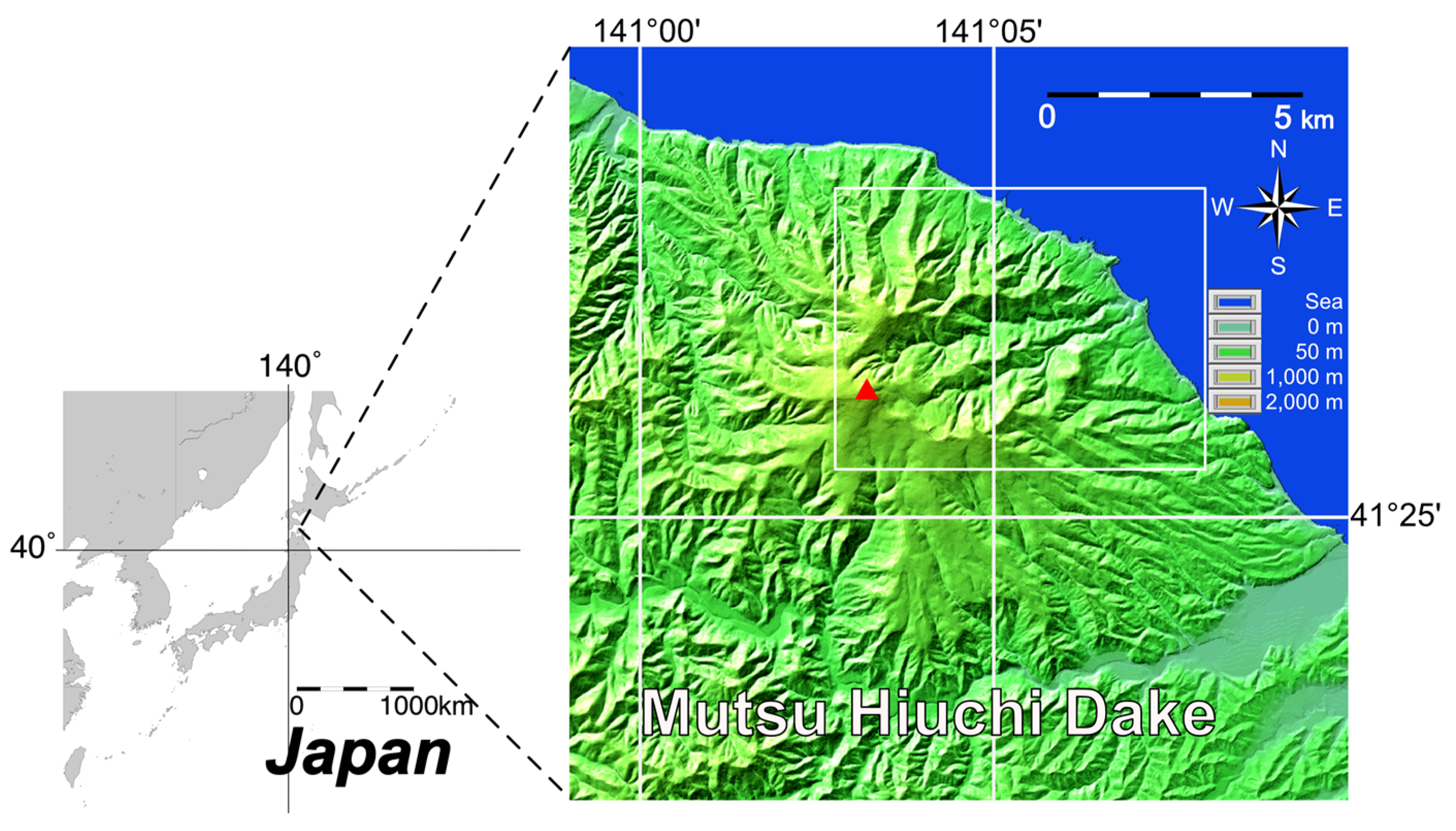
2. Mutsu Hiuchi Dake Geothermal Field
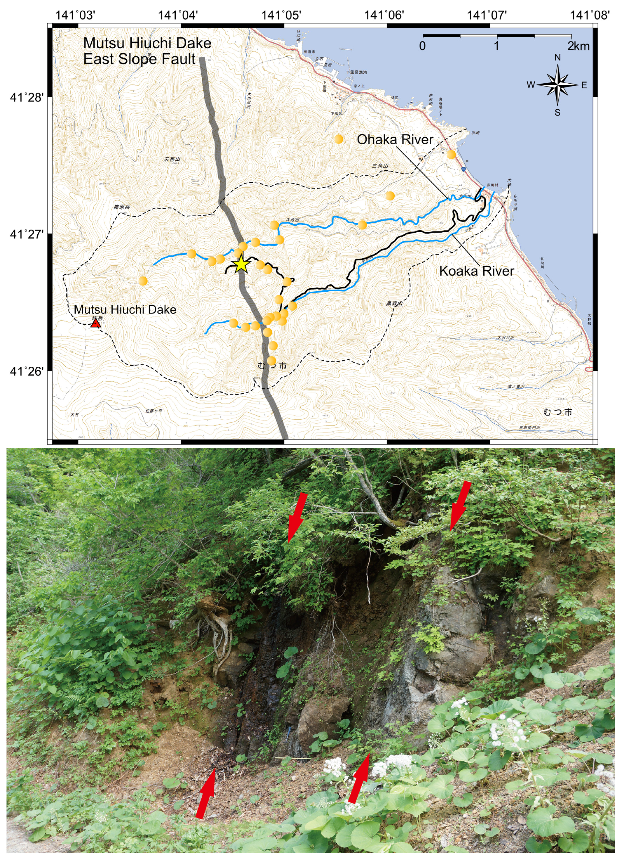
3. The Discovery of Mutsu Hiuchi Dake East Slope Fault
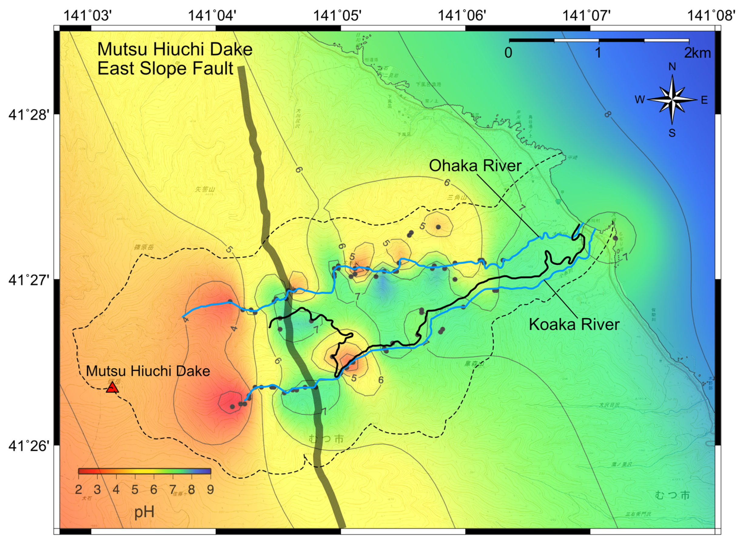
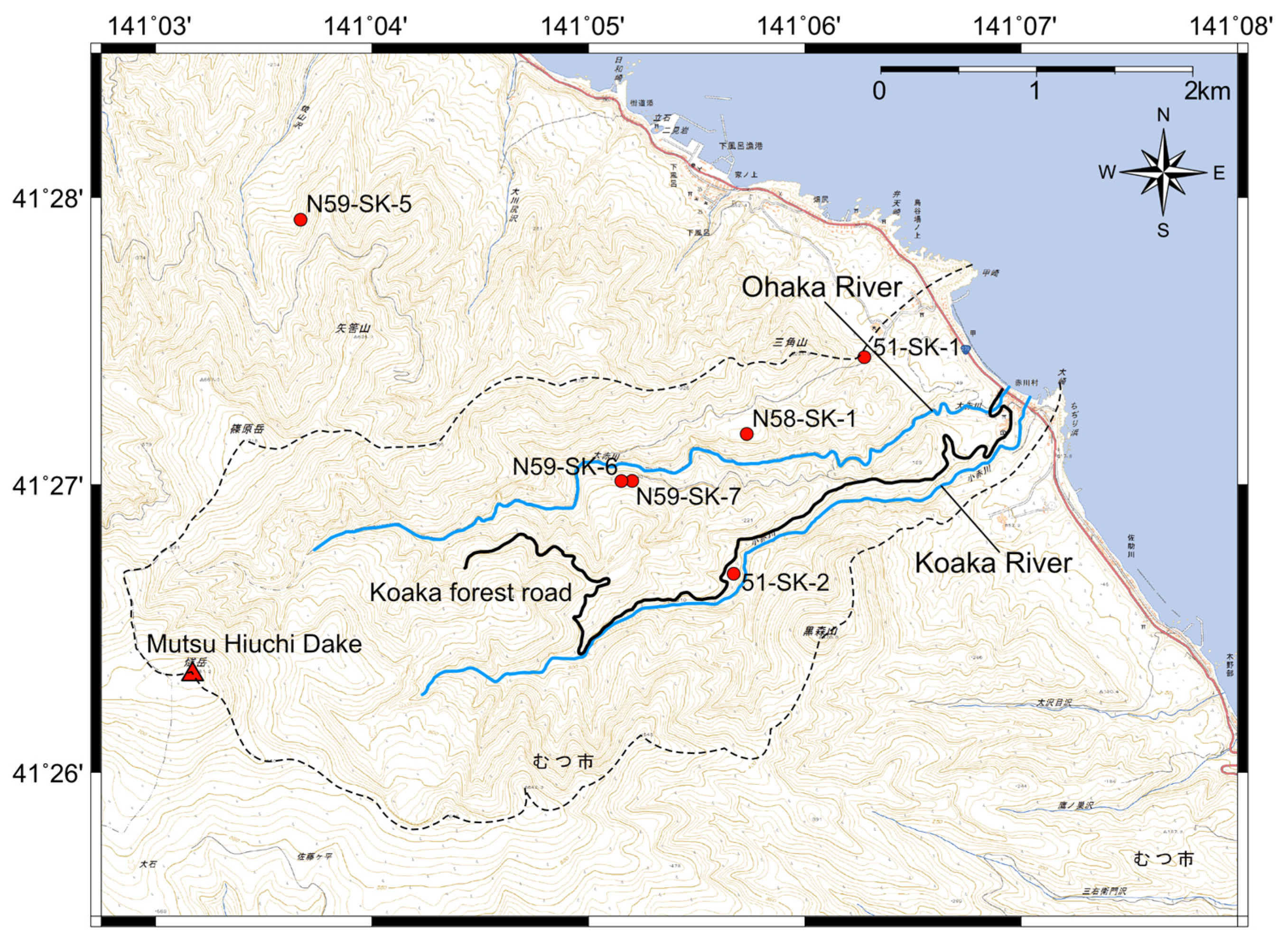
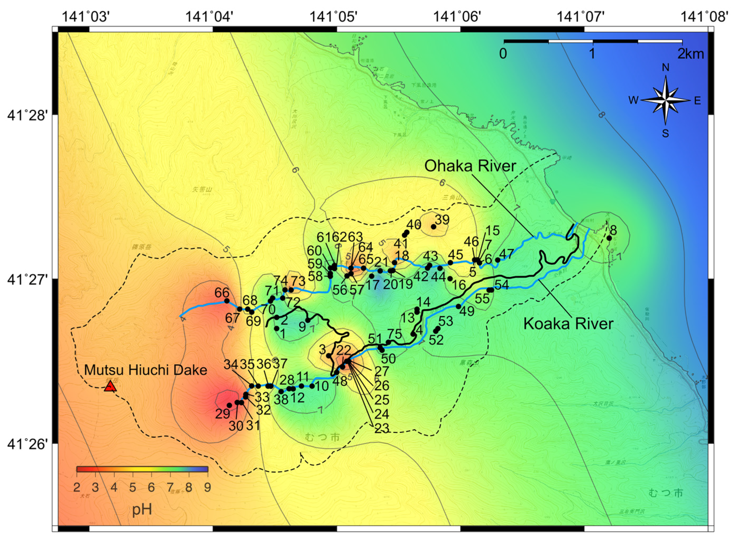
4. pH Distribution in Stream and Spring Water
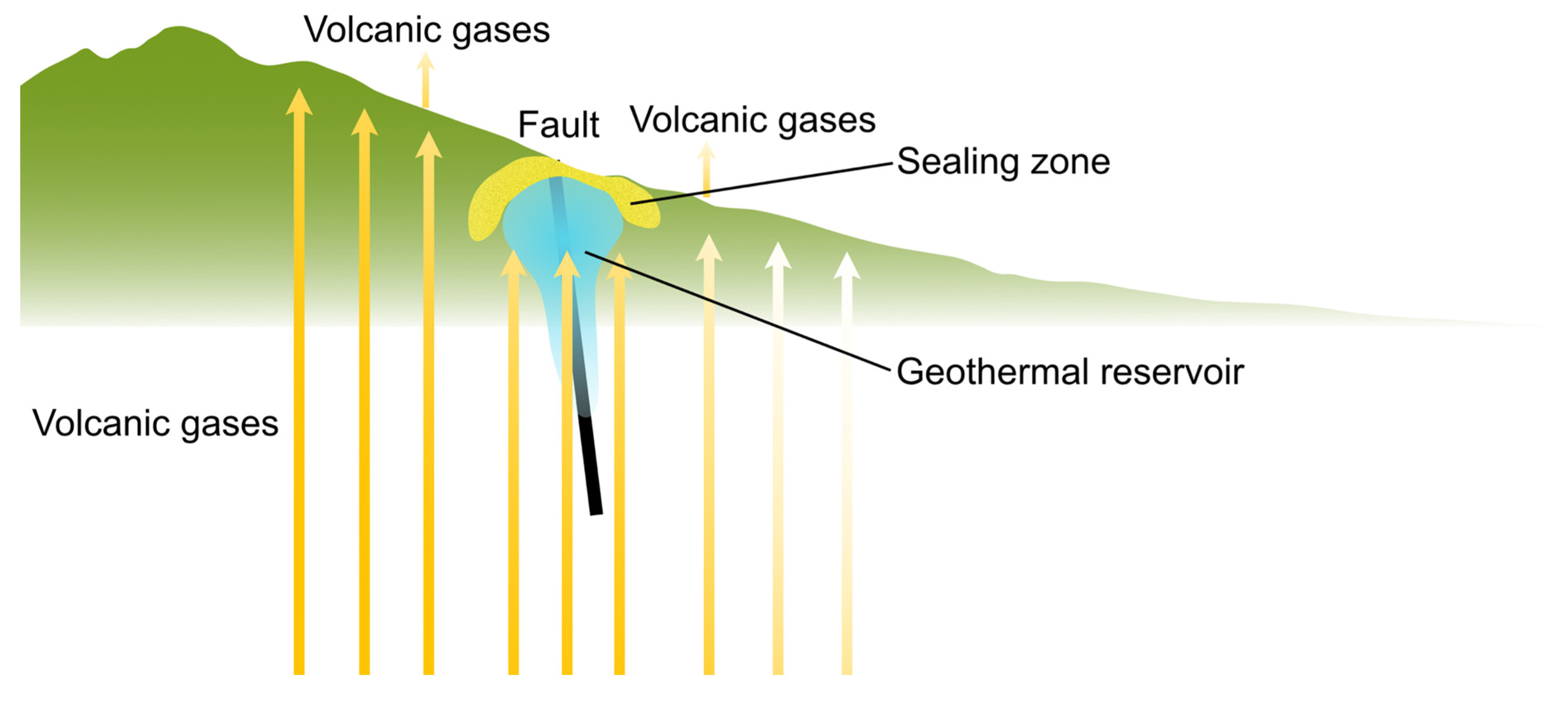
5. Discussion: pH Mapping as a New Geothermal Exploration Method
6. Conclusions
Acknowledgments
Author Contributions
Conflicts of Interest
References
- Bertani, R. Geothermal power generation in the world 2010–2014 update report. Geothermics 2016, 60, 31–43. [Google Scholar] [CrossRef]
- Publication Committee of Geothermal Energy Handbook of the Geothermal Research Society of Japan. Geothermal Energy Handbook; Ohmsha: Tokyo, Japan, 2014; p. 923. (In Japanese) [Google Scholar]
- Huenges, E. Geothermal Energy Systems: Exploration, Development, and Utilization; WILEY-VCH: Weinheim, Germany, 2010; p. 463. [Google Scholar]
- Glassley, W.E. Geothermal Energy: Renewable Energy and the Environment, 2nd ed.; CRC Press: Boca Raton, FL, USA, 2014; p. 381. [Google Scholar]
- Arnórsson, S. Isotopic and Chemical Techniques in Geothermal Exploration, Development and Use: Sampling Methods, Data Handling, Interpretation; International Atomic Energy Agency: Vienna, Austria, 2000; p. 351. [Google Scholar]
- Arnórsson, S. Geochemistry and geothermal resources in Iceland. In Application of Geochemistry in Geothermal Reservoir Development; UNITAR and UNDP: Rome, Italy, 1991; pp. 145–196. [Google Scholar]
- Heneley, R.W.; Ellis, A.J. Geothermal systems, ancient and modern. Earth Sci. Rev. 1983, 19, 1–50. [Google Scholar] [CrossRef]
- Rosell, J.B.; Tamboboy, R.J.T.; Sambrano, B.G.; Dacillo, D.B.; Reed, M.H. Mt. Apo fluid evolution: Exploring the role of rock buffers in the reservoir pH changes with time. In Proceedings of the World Geothermal Congress 2015, Melbourne, Australia, 19–25 April 2015; pp. 1–7. [Google Scholar]
- Muraoka, H.; Sakaguchi, K.; Tamanyu, S.; Sasaki, M.; Shigeno, H.; Mizugaki, K. Atlas of Hydrothermal Systems in Japan; Geological Survey of Japan, AIST: Tsukuba, Japan, 2007; p. 110. (In Japanese) [Google Scholar]
- Giggenbach, W.F. Geothermal solute equilibria: Derivation of Na-K-Mg-Ca geoindicators. Geochimica et Cosmochimica Acta 1988, 52, 2749–2765. [Google Scholar] [CrossRef]
- Arnórsson, S. Processes influencing the pH of geothermal waters. In Proceedings of the World Geothermal Congress 1995, Firenze, Italy, 18–31 May 1995; pp. 657–962. [Google Scholar]
- Muraoka, H. Summary of the heat source distribution investigation. In Trend and Development Technology of Geothermal Power; Science and Technology: Tokyo, Japan, 2011; pp. 125–137. (In Japanese) [Google Scholar]
- Geological Survey of Japan, AIST. Volcanoes of Japan, 3rd ed.; Geological Survey of Japan, AIST: Tsukuba, Japan, 2013. (In Japanese) [Google Scholar]
- Suzuki, Y.; Ioka, S.; Muraoka, H. Determining the maximum depth of hydrothermal circulation using geothermal mapping and seismicity to delineate the depth to brittle-plastic transition in northern Honshu, Japan. Energies 2014, 7, 3503–3511. [Google Scholar] [CrossRef]
- Suzuki, Y.; Ioka, S.; Muraoka, H. Comparative study of the subsurface thermal structure in northern Honshu, Japan, based on normalized temperature data and solute geothermometers. Energies 2016, 9, 382. [Google Scholar] [CrossRef]
- Uemura, F.; Saito, M. 1:50,000 Geological Map of Japan, Ohata with Explanatory Text; Geological Survey of Japan: Tokyo, Japan, 1957; p. 31. (In Japanese) [Google Scholar]
- New Energy Development Organization (NEDO). Report of Geothermal Development Promotion Survey No. 9, Shimokita Region; New Energy Organization (NEDO): Kawasaki, Japan, 1986; p. 688. (In Japanese) [Google Scholar]
- Tomiyama, S.; Umeda, K.; Hanamuro, T.; Takashima, I.; Hayashi, S.; Negishi, Y.; Masudome, Y. Alteration type and thermoluminescence ages of altered rocks in the Mutsu-Hiuchidake volcanic field, Shimokita peninsula, NE Japan. Rocks Miner. Sci. (Ganseki Koubutsu Kagaku) 2007, 36, 111–121. (In Japanese) [Google Scholar] [CrossRef]
- Muraoka, H.; Suzuki, Y.; Ioka, S.; Mikami, A.; Kato, K.; Matsuda, M. Finding the Hiuchidake East Slope Fault in Mutsu Hiuchidake Volcano and its significance to the future geothermal exploitation. In Proceedings of the 2014 Annual Meeting Geothermal Research Society of Japan, Hirosaki, Japan, 29–31 October 2014. (In Japanese). [Google Scholar]
- Suzuki, Y.; Matsuda, M.; Ioka, S.; Muraoka, H. Structural and geothermal geology on the Hiuchi-dake East Slope Fault in Shimokita Peninsula, Japan. In Proceedings of the 2015 Annual Meeting Geothermal Research Society of Japan, Beppu, Japan, 21–23 October 2015. (In Japanese). [Google Scholar]
- Wessel, P.; Smith, W.H.F. New, improved version of the Generic Mapping Tools released. Eos Trans. Am. Geophys. Union 1998, 79, 579. [Google Scholar] [CrossRef]
- Henley, R.W. Chemical structure of geothermal systems. In Fluid-Mineral Equilibria in Hydrothermal Systems, Reviews in Economic Geology; Robertson, J.M., Ed.; Society of Economic Geologists: Littleton, CO, USA, 1984; Volume 1, pp. 9–30. [Google Scholar]
- Shimada, K. Geochemical modeling (Geochemistry for Geothermal Development). Chinetsu 2000, 3, 36–56. (In Japanese) [Google Scholar]


| No. | Water Type | Sampling Date | Longitude | Latitude | pH |
|---|---|---|---|---|---|
| 1 | Spring water | 3 June 2014 | 141°4′31′′ E | 41°26′42′′ N | 7.39 |
| 2 | Stream water | 3 June 2014 | 141°4′31′′ E | 41°26′46′′ N | 7.49 |
| 3 | Stream water | 3 June 2014 | 141°4′56′′ E | 41°2°6′32′′ N | 3.95 |
| 4 | Stream water | 3 June 2014 | 141°5′37′′ E | 41°26′40′′ N | 6.69 |
| 5 | Hot Spring | 25 November 2015 | 141°6′8′′ E | 41°27′7′′ N | 6.03 |
| 6 | Hot Spring | 4 June 2014 | 141°6′9′′ E | 41°27′6′′ N | 6.05 |
| 7 | Hot Spring | 4 June 2014 | 141°6′9′′ E | 41°27′6′′ N | 6.08 |
| 8 | Spring water | 20 August 2014 | 141°7′12′′ E | 41°27′15′′ N | 6.44 |
| 9 | Stream water | 30 July 2015 | 141°4′46′′ E | 41°26′45′′ N | 7.68 |
| 10 | Stream water | 3 August 2015 | 141°4′48′′ E | 41°26′21′′ N | 7.34 |
| 11 | Stream water | 3 August 2015 | 141°4′43′′ E | 41°26′21′′ N | 7.40 |
| 12 | Spring water | 3 August 2015 | 141°4′39′′ E | 41°26′20′′ N | 6.56 |
| 13 | Stream water | 3 August 2015 | 141°5′39′′ E | 41°26′48′′ N | 6.78 |
| 14 | Stream water | 3 August 2015 | 141°5′39′′ E | 41°26′49′′ N | 7.02 |
| 15 | Stream water | 4 August 2015 | 141°6′8′′ E | 41°27′7′′ N | 7.56 |
| 16 | Stream water | 28 August 2015 | 141°5′55′′ E | 41°26′60′′ N | 6.36 |
| 17 | Stream water | 28 August 2015 | 141°5′17′′ E | 41°27′1′′ N | 7.70 |
| 18 | Spring water | 14 September 2015 | 141°5′28′′ E | 41°27′6′′ N | 4.13 |
| 19 | Spring water | 14 September 2015 | 141°5′27′′ E | 41°27′3′′ N | 6.75 |
| 20 | Spring water | 14 September 2015 | 141°5′26′′ E | 41°27′3′′ N | 6.43 |
| 21 | Stream water | 14 September 2015 | 141°5′21′′ E | 41°27′3′′ N | 7.85 |
| 22 | Spring water | 26 April 2016 | 141°5′3′′ E | 41°26′28′′ N | 3.27 |
| 23 | Stream water | 26 April 2016 | 141°5′6′′ E | 41°26′30′′ N | 3.09 |
| 24 | Spring water | 26 April 2016 | 141°5′5′′ E | 41°26′30′′ N | 5.69 |
| 25 | Spring water | 26 April 2016 | 141°5′5′′ E | 41°26′30′′ N | 2.97 |
| 26 | Spring water | 26 April 2016 | 141°5′5′′ E | 41°26′30′′ N | 3.42 |
| 27 | Spring water | 26 April 2016 | 141°5′6′′ E | 41°26′30′′ N | 3.67 |
| 28 | Stream water | 27 April 2016 | 141°4′37′′ E | 41°26′20′′ N | 7.40 |
| 29 | Spring water | 27 April 2016 | 141°4′8′′ E | 41°26′14′′ N | 2.63 |
| 30 | Spring water | 27 April 2016 | 141°4′12′′ E | 41°26′15′′ N | 2.73 |
| 31 | Spring water | 27 April 2016 | 141°4′14′′ E | 41°26′15′′ N | 3.35 |
| 32 | Spring water | 27 April 2016 | 141°4′16′′ E | 41°26′17′′ N | 3.05 |
| 33 | Stream water | 27 April 2016 | 141°4′16′′ E | 41°26′18′′ N | 3.59 |
| 34 | Spring water | 27 April 2016 | 141°4′19′′ E | 41°26′21′′ N | 7.02 |
| 35 | Spring water | 27 April 2016 | 141°4′22′′ E | 41°26′21′′ N | 3.38 |
| 36 | Spring water | 19 May 2016 | 141°4′27′′ E | 41°26′21′′ N | 3.44 |
| 37 | Stream water | 19 May 2016 | 141°4′28′′ E | 41°26′21′′ N | 7.02 |
| 38 | Stream water | 19 May 2016 | 141°4′33′′ E | 41°26′19′′ N | 7.48 |
| 39 | Stream water | 7 June 2016 | 141°5′47′′ E | 41°27′19′′ N | 4.48 |
| 40 | Spring water | 7 June 2016 | 141°5′34′′ E | 41°27′17′′ N | 3.49 |
| 41 | Stream water | 7 June 2016 | 141°5′33′′ E | 41°27′16′′ N | 7.26 |
| 42 | Spring water | 8 June 2016 | 141°5′44′′ E | 41°27′4′′ N | 7.59 |
| 43 | Spring water | 8 June 2016 | 141°5′45′′ E | 41°27′5′′ N | 7.57 |
| 44 | Spring water | 8 June 2016 | 141°5′50′′ E | 41°27′4′′ N | 7.72 |
| 45 | Stream water | 8 June 2016 | 141°5′55′′ E | 41°27′6′′ N | 5.24 |
| 46 | Spring water | 15 June 2016 | 141°6′7′′ E | 41°27′7′′ N | 5.66 |
| 47 | Stream water | 15 June 2016 | 141°6′18′′ E | 41°27′7′′ N | 7.36 |
| 48 | Stream water | 7 July 2016 | 141°5′0′′ E | 41°26′26′′ N | 6.88 |
| 49 | Stream water | 7 July 2016 | 141°5′59′′ E | 41°26′50′′ N | 7.45 |
| 50 | Stream water | 8 July 2016 | 141°5′22′′ E | 41°26′34′′ N | 7.44 |
| 51 | Stream water | 8 July 2016 | 141°5′21′′ E | 41°26′35′′ N | 7.42 |
| 52 | Stream water | 8 July 2016 | 141°5′48′′ E | 41°26′41′′ N | 7.49 |
| 53 | Stream water | 8 July 2016 | 141°5′49′′ E | 41°26′42′′ N | 7.25 |
| 54 | Stream water | 8 July 2016 | 141°6′15′′ E | 41°26′56′′ N | 7.10 |
| 55 | Stream water | 8 July 2016 | 141°6′14′′ E | 41°26′56′′ N | 6.24 |
| 56 | Stream water | 12 July 2016 | 141°5′5′′ E | 41°27′1′′ N | 7.04 |
| 57 | Stream water | 12 July 2016 | 141°5′7′′ E | 41°27′2′′ N | 6.94 |
| 58 | Stream water | 13 July 2016 | 141°4′57′′ E | 41°27′1′′ N | 7.03 |
| 59 | Spring water | 13 July 2016 | 141°4′57′′ E | 41°27′2′′ N | 7.76 |
| 60 | Stream water | 13 July 2016 | 141°4′57′′ E | 41°27′4′′ N | 7.50 |
| 61 | Stream water | 13 July 2016 | 141°4′59′′ E | 41°27′5′′ N | 7.31 |
| 62 | Spring water | 13 July 2016 | 141°4′59′′ E | 41°27′4′′ N | 2.48 |
| 63 | Stream water | 13 July 2016 | 141°5′7′′ E | 41°27′4′′ N | 2.98 |
| 64 | Stream water | 13 July 2016 | 141°5′7′′ E | 41°27′4′′ N | 2.88 |
| 65 | Stream water | 13 July 2016 | 141°5′13′′ E | 41°27′4′′ N | 4.02 |
| 66 | Stream water | 22 July 2016 | 141°4′7′′ E | 41°26′52′′ N | 3.17 |
| 67 | Stream water | 22 July 2016 | 141°4′13′′ E | 41°26′49′′ N | 3.85 |
| 68 | Stream water | 22 July 2016 | 141°4′17′′ E | 41°26′49′′ N | 6.90 |
| 69 | Stream water | 22 July 2016 | 141°4′19′′ E | 41°26′48′′ N | 4.79 |
| 70 | Stream water | 22 July 2016 | 141°4′28′′ E | 41°26′52′′ N | 6.72 |
| 71 | Stream water | 22 July 2016 | 141°4′29′′ E | 41°26′53′′ N | 7.25 |
| 72 | Stream water | 22 July 2016 | 141°4′34′′ E | 41°26′53′′ N | 7.55 |
| 73 | Spring water | 10 October 2016 | 141°4′38′′ E | 41°26′56′′ N | 3.18 |
| 74 | Stream water | 10 October 2016 | 141°4′35′′ E | 41°26′56′′ N | 6.92 |
| 75 | Stream water | 10 October 2016 | 141°5′25′′ E | 41°26′37′′ N | 7.35 |
© 2017 by the authors. Licensee MDPI, Basel, Switzerland. This article is an open access article distributed under the terms and conditions of the Creative Commons Attribution (CC BY) license (http://creativecommons.org/licenses/by/4.0/).
Share and Cite
Suzuki, Y.; Ioka, S.; Muraoka, H. Geothermal Resource Exploration by Stream pH Mapping in Mutsu Hiuchi Dake Volcano, Japan. Energies 2017, 10, 1009. https://doi.org/10.3390/en10071009
Suzuki Y, Ioka S, Muraoka H. Geothermal Resource Exploration by Stream pH Mapping in Mutsu Hiuchi Dake Volcano, Japan. Energies. 2017; 10(7):1009. https://doi.org/10.3390/en10071009
Chicago/Turabian StyleSuzuki, Yota, Seiichiro Ioka, and Hirofumi Muraoka. 2017. "Geothermal Resource Exploration by Stream pH Mapping in Mutsu Hiuchi Dake Volcano, Japan" Energies 10, no. 7: 1009. https://doi.org/10.3390/en10071009