1. Introduction
In a recent article, Leigh and colleagues ask, “Why do some tropical forests have so many species of trees?” [
1]. The answer is critical to understanding how to protect and manage the remaining biological diversity, and in some cases, to restore that diversity, in the vast tropical regions of Earth. The authors breakdown the complex issue into a series of questions and propose that tree “species that are now common must have spread more quickly than chance allows,” assuming that new species probably begin as small populations, and thus, certain niche opportunities promote the increase of these originally rare species [
2]. Agreeing with previous scholars who emphasize long-term environmental stability and a warm and relatively low seasonality, Leigh and colleagues conclude, “… neither disturbance nor microhabitat specialization can explain the diversity of tropical trees, even though larger-scale habitat and climate differences are the primary causes of species turnover. Increased activity of specialized pests and pathogens in less seasonal climates appears to be a primary cause of the latitudinal gradient in tree diversity” [
3].
In reaching their conclusions, the authors ignore the long and complex human history of tropical forest environments extending back into the late Pleistocene. What possible role could human activities have played in providing the “niche opportunity” for originally rare species and the spread, distribution, and maintenance of individual tree species, α-diversity, and β-diversity in the tropics?
Symphonia globulifera, often known as the “wax tree” in indigenous languages because of its exudate, is a widespread tree that thrives in different conditions throughout the Neotropics, even though it makes up less than 2% of the trees in any individual forest [
4]. Leigh and colleagues use this species as an example of a rare tree’s exploitation of specific niche opportunities that protect it from replacement by competitors and allow increase in numbers despite being initially rare, while at the same time promoting the coexistence of diverse species. Historical ecologist Balée [
5] points out that for native peoples,
Symphonia globulifera is an important economic and ritual species whose wood, saps, resins, and lattices are used for construction, medicines (abortifacient and prevention of menstruation), combustion of torches, and adhesives. Could this value to native peoples have been a factor in the success of this tree throughout the diverse ecosystems of the Neotropics?
In contrast to niche opportunity provided by nature proposed by Leigh and colleagues, historical ecologists favor human agency and intentionality, since human activities in the Amazon can promote the rapid distribution and success of isolated rare species in the competitive tree environment of a typical Amazonian forest. Moving and transplanting useful species into new habitats and providing an edge over already-established communities of plants through activities such as opening light gaps, cultivating, fertilizing, mulching, and weeding are common in indigenous societies of Amazonia [
6]. The Kayapó and other Amazonian peoples have hundreds of fruit and nut trees originally sprouted from discarded seeds and encouraged in previous clearings around settlements and camps. In the case of the Ka’apor, former clearings and settlements attract later human foragers and seed-dispersing animals, who thereby ensure the continued dispersal and success of certain species [
6]. Many of the animals attracted to these stands are also important game [
7,
8]. Hastorf [
9] proposes that much of the early distribution of useful and interesting species throughout the world may be due to plant “mothering, nurturing, or midwifery” by women in contrast to the traditional “husbandry,” cultivation, and later domestication as crops that is often attributed to males in scenarios of the origins of agriculture. Hastorf focuses on new plant-human relationships, in particular women’s complex networks of reciprocity and their propensity for bringing rare plants into human society through naming, classifying, designating kinship relationships, assigning symbolism, and solidifying ties through gifting documented in ethnographies. Through adoption into human society, rare plants that would have a difficult time surviving to reproduce in the wild in rainforests are protected and encouraged within contexts of settlements, house gardens and later fields. In addition, these social networks can move plants rapidly from village to village over large geographical space [
10]. The spread of many ornamentals and useful plants from Asia and Africa throughout the Neotropics are more recent examples of similar human societal practices that provide what natural scientists refer to as “niche opportunities” for the successful dispersion of rare plants and an overall increase in biodiversity.
Although the above human activities can result in significant and widespread environmental transformation given enough time, the impact is relatively mild compared to what humans did in the engineered landscapes of the Bolivian Amazon, the garden cities of the Upper Xingu region, and vast extensions of anthropogenic soils in the Central and Lower Amazon regions. Recent archaeological research shows that Native Amazonians domesticated a wide range of crops [
11], practiced agro-forestry [
12], constructed fertile soils (Amazonian Dark Earths or
terra preta) [
13], and transformed their environment into a highly productive and orderly cultural landscape [
14,
15,
16,
17].
In this article, I explore specific human activity that massively transformed nature into a highly patterned, engineered cultural landscape of regional scale in the Baures region in the northeast corner of the Bolivian Amazon (Province of Iténez, Department of the Beni). A type of monumental earthwork, the ring ditch, is described and analyzed in terms of form, scale, energetics, chronology, and its environmental impact on forest composition, structure, biomass, and diversity, a key component of the historical ecology of the Bolivian Amazon. Ring ditches are large enclosures, sometimes multiple concentric rings, some covering more than one square kilometer, that were created through the excavation of a deep trench (up to 4.5 m deep and 10 m wide) on forest islands or bluffs overlooking savannas, wetlands, and rivers. The proposed functions of ring ditches include defense, settlements, elite residences, land and resource markers, animal traps, cemeteries, water management features, and/or public ceremonial spaces [
18]. These structures, often called “geoglyphs” because of their symmetry and complex geometric designs, are monumental in scale. The distribution of ring ditches and other archaeological remains throughout western Amazonia suggests a common culture of closely interacting societies in late prehistory [
19,
20,
21].
I propose that the construction of large earthworks on forest islands had significant impact on the local environment and biodiversity. During the construction and use of these massive earthworks, the area of ditch and enclosed space was deforested and kept so for centuries. If ring ditches were constructed for defense, the need for open views across the forest islands and savanna required additional clearing of forest. According to early European accounts, the inhabitants of the region built palisades of tree trunks encircling villages. Tens of thousands of trees were necessary to wall some of the larger ring ditches, which enclose over a square kilometer. Computer mapping and modeling of data collected during fieldwork are used to calculate the necessary materials and human labor to construct and maintain these monumental earthworks and palisades and to evaluate their environmental impact at various spatial and temporal scales.
I will show that the impact of these earthworks on the forest island environments was far beyond the effects of traditional human activities documented in the historical and ethnographic record, such as slash and burn agriculture, gardening, agroforestry, and settlement. Through the complete or partial deforestation of forest islands in the region, the biodiversity “slate” was “wiped clean” with a near complete turnover of species. I will also address the following questions: Did these forest removal and earthmoving activities result in environmental degradation? Did these activities play a role in determining the content and structure present day biodiversity in the region?
2. Historical Ecology and the Archaeology of Landscapes
Despite early historical accounts by eyewitnesses describing still flourishing complex societies in numerous locations throughout the Amazon and adjacent Neotropics [
22,
23,
24], the indigenous societies ravaged by conquest, epidemics, exploitation, wars, and colonial policies encountered by later historians, ethnographers, archaeologists, and travelers were interpreted as representative of their ancestors. The environment of the Amazon region of tropical South America was long considered to be of limited potential for cultural development. As a result, scholars assumed that the simple social and political organization, nomadic or semi-sedentary lifeways characterized by hunting, gathering, fishing, and small-scale agriculture of the historic and contemporary native peoples reflected pre-Columbian conditions [
25,
26]. These traditional interpretations feed the myths of low pre-Columbian human populations, a pristine environment, and the ecologically noble savage through their ignoring of or misreading the complex signatures of the human history embedded in the landscapes of Amazonia.
Site based archaeologists and natural scientists are often oblivious to the subtle and not so subtle signatures of past human activities. Most archaeological research is about sites while most day-to-day pre-Columbian activities in the Bolivian Amazon occurred in the cultural landscape. In the Baures region where I work, little evidence of settlement is found compared to that of other areas of the Bolivian Amazon or Amazonia in general (e.g., large quantities of potsherds and other domestic debris, Amazonian Dark Earth, and mounds). Based on a traditional archaeological perspective focused on sites, one would conclude that the region had a small population and assume little impact on the environment based on occupation site number and size. Because native peoples of Amazonia spent considerable time outside the confines of settlements, site based archaeology provides limited insights about how past native peoples interacted with and shaped their environments.
In contrast to the focus on sites in mainstream archaeology, the archaeology of landscapes focuses on the space between sites [
27,
28,
29]. Landscape archaeology and historical ecology investigates how complex interacting natural and cultural processes transformed environment into cultural or anthropogenic landscape. As physical features determined by human culture, landscape elements are often highly patterned, relatively permanent, and visible on the surface for study at multiple temporal and spatial scales. Archaeological interpretation of patterned cultural features in the landscape can provide a window into prehistoric social organization, spatial order, land tenure, community structure, native cosmology, calendrics, settlement systems, land tenure, subsistence lifeways, technology, and traditional knowledge systems. In addition to cultural built environment such as earthworks, boundary markers, roads, alignments, shrines, and historical places, signatures of anthropogenic landscapes include non-random concentrations of economic species of plants and animals, oligarchic forests, artificially enriched soils, charcoal from fires, and species outside their natural habitats [
13,
39]. Over time, landscapes can become a palimpsest or complex layering of accumulated patterned cultural infrastructure imposed upon the landscape and thus, landscapes are amenable to temporal analysis and dating.
3. The Environment and History of the Baures Region
Baures is the name of a region, a district, a town, a language (Baure), and a native ethnic group (Baure) in the Province of Iténez, Department of the Beni in the northeastern corner of Bolivia. A complex mix of gallery forests, forest islands, savanna (open grasslands), wetlands, rivers, and large shallow lakes characterizes the Baures region and the larger Llanos de Mojos (plains of Mojos). The year is divided into a wet season with 3–6 months of extensive flooding of the flat landscape and a dry season with 3–6 months of conditions when surface water can become scarce. The local inhabitants practice swidden agriculture, gardening, agroforestry, hunting, collecting, fishing, and ranching. Despite the presence of poor tropical soils, farming on the higher forested ground is productive.
After Spanish conquest of the Bolivian Amazon, the Jesuits established mission towns to control, convert, and exploit the native peoples in the Baures region. The Jesuits considered the Baure to be the most impressive of the indigenous peoples in the Bolivian Amazon [
31,
32,
33,
34,
35,
36]. Hereditary chiefs (
aramas) held considerable power over their subjects, especially in relation to agricultural production, mobilization of warriors and agricultural labor, and public order. Traditional Baure towns were large by Amazonian standards and were laid out in formal plans that included streets, spacious public plazas, residences, temples, and men's houses. According to the Jesuits, many towns were surrounded by deep ditches and wooden palisades. Settlements were connected by wide causeways and canals that enabled year round travel across savannas and wetlands [
37]. These Baure and possibly other ethnic groups are the descendants of the people who constructed a vast landscape of earthworks found within the gallery forests, forested islands, wetlands, and savannas in the pre-Columbian period (before 1492) or protohistorical period (1492 until 1704, the date when the Baure were brought under Spanish control). Although some continued in use during the early Colonial period, the earthworks were probably not being constructed or maintained. The disruption that resulted from conquest, resettlement, proselytization, civil wars, border disputes, epidemics, and slavery during the Colonial and later periods caused the abandonment of these earthworks, depopulation of the region, and the decline of native cultures.
3.1. Forest Islands
Forest islands (
islas de monte) are common features of the Bolivian Amazon formed by a combination of geomorphological processes and anthropogenic activities including earthmoving, settlement, and agriculture [
38,
39]. The forest islands throughout most of the Llanos de Mojos are on low levees along active rivers and streams or remnants of levees and fragmented gallery forests along abandoned or seasonal channels. Many forest islands are bounded on several sides by standing water in old meander loops that helps protect them from the annual burns of savanna vegetation, thus allowing the establishment of trees and other diverse forest resources. The slight elevation provided a dry location for sheltering animals and human settlements. Over time, the drainage and size of forest islands was improved through the addition of soil, settlement refuse, and house construction, which raised many islands the structure several meters so they became low mounds. Others are almost completely anthropogenic mounds (
lomas), some reaching 14m in elevation and surrounded by deep barrow pits with standing water [
40,
41].
In contrast, most forest islands in the Baures region were formed by upwellings and subsequent erosion of exposures of the Precambrian [Brazilian] Shield. Forest islands range in size from less than 100 ha to many square kilometers and in elevation from a few meters to in rare cases as high as 100 m in rare cases above the surrounding savanna and wetlands. Thousands of years of human settlement, farming, agroforestry, and earthwork construction transformed the surfaces of these natural forest islands into complex cultural landscapes.
Two major forest types can be found in the Baures region [
42]. The dominant formation, Wet Savanna is characterized by a sub-humid climate of 2–6 dry months, an annual precipitation of 1,000 to more than 2,000 mm, and annual mean temperature of 26
oC. The savanna is annually flooded from a few centimeters to several meters of water during the wet season. Large forest islands have considerable diversity, enhanced by the zonation between inundated savanna/permanent wetlands and dry surfaces of the islands. Vast Precambrian Shield Forests are common on higher ground to the north, south, and east of the Baures region. These forests include evergreen and deciduous trees and have an annual precipitation of 1,200–1,800 mm, 2–4 dry months, and an average mean temperature of 25
oC.
3.2. Archaeological Remains of Ring Ditches in the Baures Region
Archaeological landscape features in the Baures region include ring ditch sites, occupation sites, causeways and canals, artificial ponds, fish weirs, and raised fields. These earthworks are estimated to cover 12,000 km
2 [
43], although the area of the continuous distribution of earthworks is smaller. Nordenskiöld first reported the ring ditch sites, large causeways, and canals of the region [
44,
45]. Denevan described several causeways and canals near the town of Baures and reported ring ditch sites in Baures and Magdalena [
46]. In the late 1950s, Lee reported remains of the vast networks of causeways and canals in the savanna between the San Joaquin and San Martin rivers and named them the “Baures Hydraulic Complex” [
43]. Erickson and colleagues documented a large landscape of fish weirs [
47], in addition to causeways, canals, and raised fields [
18,
37,
48].
Ring ditch sites are known locally as
zanjas, fosos (pits, ditches, or moats), and
trincheras (trenches), and by scholars as moated sites, ditched sites, trench-like earthworks, circular ditches, ditched enclosures, circular village-plazas, geometrically patterned earthworks, and geoglyphs (
Figure 1). Ring ditches are archaeological sites enclosed by continuous or near continuous ditch, with the excavated earth piled on the inside and/or outside as adjacent low berms (
Figure 2). In the Baures region, these earthworks are found on forest islands within the savanna. Along the Branco, Mamoré, Madeira, Orton, Madre de Dios, Beni, and Guaporé rivers, ring ditch sites are found on bluffs adjacent to the rivers. Although circles, ellipses, and irregular shapes are most common, we identified octagonal, hexagonal, square, rectangular, “D” and “U” shapes, as well as clusters of ring ditches and concentric ring ditches. Because of their symmetry, design, and aesthetic appeal, ring ditches in Brazil are referred to as “geoglyphs” [
21].
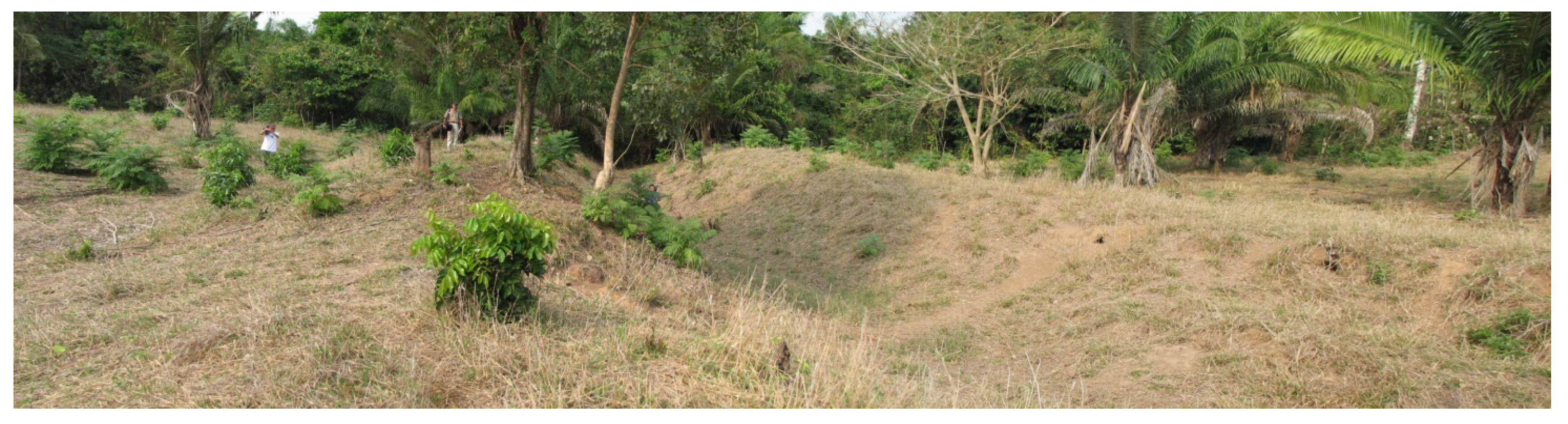
Figure 1.
Medium-sized ring ditch on the forest island of Jasiaquiri, Bolivia (dark circular band of trees in center mark the ditch).
Figure 1.
Medium-sized ring ditch on the forest island of Jasiaquiri, Bolivia (dark circular band of trees in center mark the ditch).
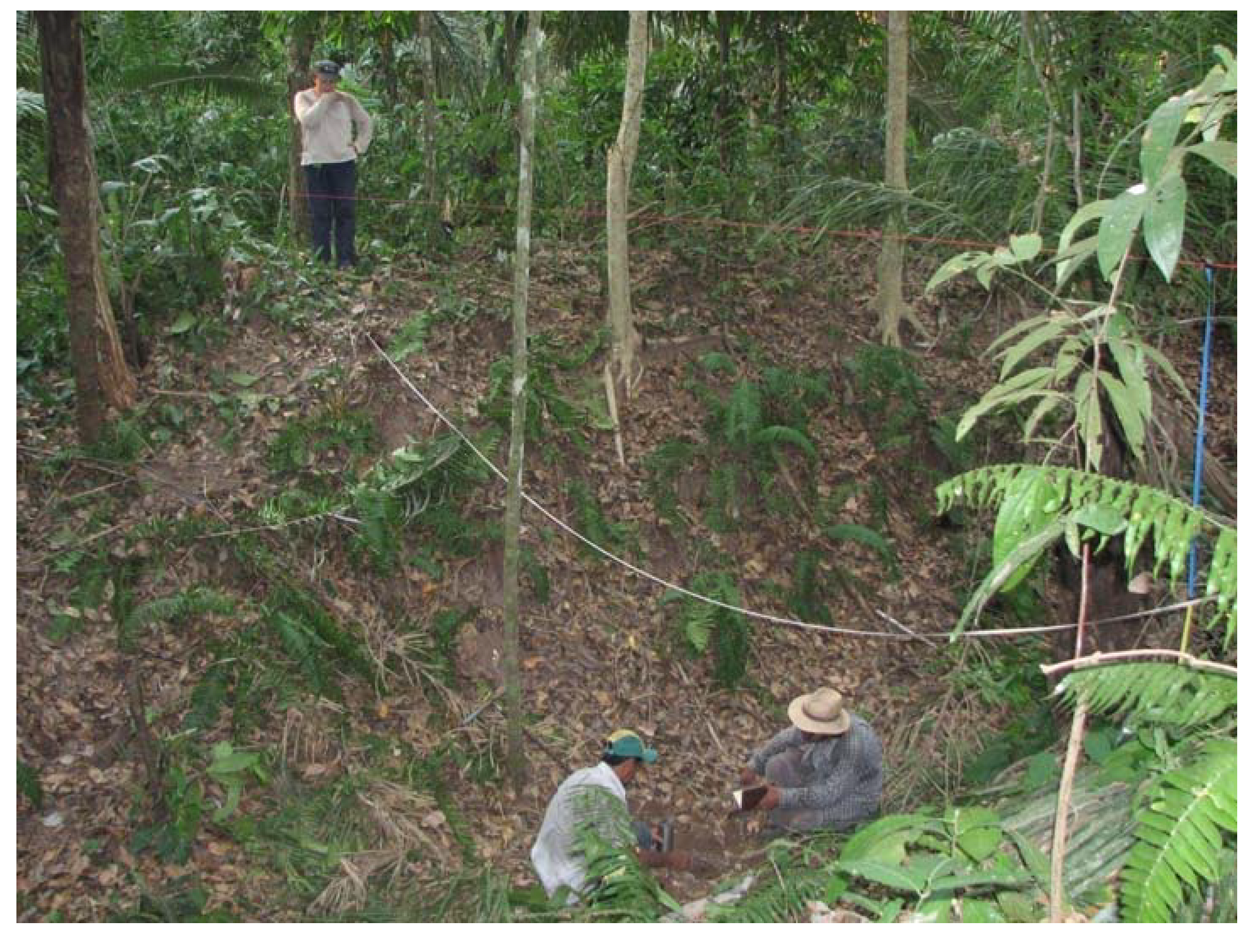
Figure 2.
Pre-Columbian ring ditch and berms on the forest island of Santa Maria near Baures, Bolivia.
Figure 2.
Pre-Columbian ring ditch and berms on the forest island of Santa Maria near Baures, Bolivia.
In his exploration of Mojos in 1832, D’Orbigny documented moats (
trincheras) between the mission towns of San Ramon and San Joaquin that he linked to the ancestral Canichana [
49]. In 1845, Palacios reported large ring ditches (
zanja o
foso) located northeast of Lake Rogoaguado [
50]. He interpreted the features as a form of defense of the abandoned large settlement of the Cayubaba against their enemies, the Chacobos, Caripunas (Pacaguaras). At the site of Matucare on the Guaporé/Iténez river, Nordenskiöld reported a long deep “moat” that “…must have skirted the settlement on the land side. The cultivated fields, too, were probably surrounded by forts” [
51]. Nordenskiöld also found potsherds on all forest islands, evidence of pre-Columbian farming in recent clearings, and large ditched enclosures surrounding any high ground. Nordenskiöld was convinced that these earthworks were for defending settlements, fields, and possibly cemeteries. Along the same river, Becker-Donner found a ditch associated with an extensive black archaeological soil at a depth of 0.8 to 1.0 m depth with urn burials and domestic debris [
52]. Bernardo Dougherty and Horacio Calandra report circular or elliptical ditches and black earth associated with settlement around Baures and Bella Vista on the Negro, Blanco, and San Martin rivers [
53,
54]. Miller reported similar large ditched sites and black earth on the Brazilian side of the middle Guaporé/Iténez river [
55].
The most complete archaeological study of ring ditches in the Bolivian Amazon before 2000 is by Arnold and Prettol at Tumi Chuqua on the Madre de Dios river near Riberalta [
56]. The earthworks are a complex of a large, near perfectly circular ring ditch covering 25ha with associated linear and curved ditches connecting to local water bodies of 125 ha. Arnold and Prettol suggest that the large ring ditch and the two smaller semi-circular ditches were used for defense of the settlement. The three associated ditches connecting to the lake and river are interpreted as short cuts for canoes to save travel time around river meanders and provide access between water bodies. These channels and those of the ring ditches would not hold water year round. In the same area, Arellano, Pärssinen, and colleagues have mapped and excavated a number of ring ditches, one of which was temporarily occupied by the Inca in late prehistory [
57,
58].
Since 1995, Erickson and colleagues have mapped 37 complete and over 20 partial ring ditches on forested islands in the Baures region (
Figure 3,
Table 1) [
18,
59,
60]. With Google Earth, we located an additional 15 unsurvyed ring ditch sites in recently deforested areas. Most ring ditches have diameters of 100–300 m and ditches of up to 4.5 m deep and 10 m wide, often with steep sidewalls. Some ring ditches are found in clusters of up to four earthworks. The forest island of Altagracia has nine complete ring ditches. Large outer ring ditches enclose nearly 2 km
2 and as many as two smaller ring ditches.
Figure 3.
Deep ring ditch at Buen Futuro, Orobayaya, Bolivia.
Figure 3.
Deep ring ditch at Buen Futuro, Orobayaya, Bolivia.
Table 1.
Ring Ditches of the Baures Region (including Magdalena, Guacaraje, Bella Vista, and Orobayaya).
Table 1.
Ring Ditches of the Baures Region (including Magdalena, Guacaraje, Bella Vista, and Orobayaya).
| Nombre | Perimeter (m) | Area (m2) | Area (ha) |
|---|
| Zanja Cerro Mercedes 1 | 5,427 | 1,764,961 | 176.4 |
| Zanja Chipeno 5 | 4,526 | 958,822 | 95.9 |
| Zanja 3 de Chipeno | 3,430 | 789,752 | 78.9 |
| Zanja 1 de Parralero | 2,833 | 584,639 | 58.5 |
| Zanja 1 de Chipeno | 2,915 | 576,732 | 57.7 |
| Zanja Guabarena III | 2,855 | 542,008 | 54.2 |
| Zanja San Miguel Viejo | 3,202 | 516,474 | 51.6 |
| Zanja de Galvez | 1,111 | 94,199 | 9.4 |
| Zanja Tranquilidad | 1,128 | 93,137 | 9.3 |
| Zanja 1 de Jasiaquiri | 1,080 | 90,233 | 9.0 |
| Zanja San Luís 1 | 1,098 | 84,422 | 8.4 |
| Zanja 1 Veremos | 984 | 73,920 | 7.4 |
| Zanja 1 La Pedorrera | 969 | 72,963 | 7.3 |
| Zanja El Pozo | 962 | 71,394 | 7.1 |
| Zanja Tujere 2 | 972 | 70,108 | 7.0 |
| Zanja 2 Chipeno | 901 | 60,409 | 6.0 |
| Zanja Céspedes II | 867 | 57,077 | 5.7 |
| Zanja Tujure 1 | 875 | 56,804 | 5.7 |
| Zanja Buen Futuro | 881 | 56,310 | 5.6 |
| Zanja 2 Veremos | 845 | 50,807 | 5.1 |
| Zanja Cairo 1 | 804 | 50,455 | 5.0 |
| Zanja San Luís 2 | 794 | 49,986 | 5.0 |
| Zanja 6 Alta Gracia | 750 | 44,292 | 4.4 |
| Zanja 1 San Carlos | 728 | 39,358 | 3.9 |
| Zanja San Luís 3 | 753 | 38,713 | 3.9 |
| Zanja 2 Santa Maria | 616 | 38,257 | 3.8 |
| Zanja San Juan | 655 | 34,025 | 3.4 |
| Zanja 1 Santa Maria | 616 | 29,072 | 2.9 |
| Zanja Santa Fe | 591 | 27,187 | 2.7 |
| Zanja Céspedes I | 584 | 25,055 | 2.5 |
| San Francisco | 553 | 23,303 | 2.3 |
| Cairo 2 | 515 | 20,487 | 2.0 |
| Zanja 2 San Carlos | 567 | 19,176 | 1.9 |
| Zanja Guabarena II | 490 | 18,457 | 1.8 |
| Zanja Catiene | 434 | 14,565 | 1.5 |
| Zanja Villa Negra I | 397 | 12,147 | 1.2 |
| Zanja Guabarena I | 316 | 7,446 | 0.7 |
Ring ditches are found in a broad arc across the southwestern Amazon basin [
19] along the Madre de Dios, Orton, Beni, and Rapulo rivers in northern Beni and Pando departments of Bolivia [
57,
58,
61,
62] and in the neighboring states of Acre, Purus, Matto Grosso, and Rondônia in Brazil [
16,
20,
21]. Some ring ditches reported along the Blanco, Guaporé/Iténez and Madeira rivers of Bolivia and Brazil are associated with terra preta or Amazonian Dark Earth (large deep, fertile black earth sites created by human activity) [
53,
55,
63].
Heckenberger attributes this phenomenon to the “Arawak Diaspora” [
64]. In Bolivia, the linguistic and ethnic context for these sites at European contact is much more complex [
32,
62]. Variations in shape, size, and location may represent different styles associated with ethnic groups or stylistic changes over time. The large ring ditches at Tumi Chuqua on the Beni river are dated to late prehistory [
56,
57,
58]. The pottery associated with some of our sites is late prehistoric. Ring ditch sites of the Upper Xingu river date to AD 1250–1650 [
64] and Acre and Purus state may be as early as AD 1300 [
20,
21].
3.3. Functions of Ring Ditches
Scholars have proposed that ring ditch sites were constructed for defense, settlements, elite residences, land and resource markers, animal traps, cemeteries, water management features, and/or public ceremonial spaces [
18]. Many ring ditches are assumed to have enclosed settlements with houses arranged in a circular or elliptical pattern around a central plaza. Pottery fragments are found on disturbed or deforested ring ditch sites in the Bolivian Amazon and elsewhere. In our experience, pottery, other artifacts, and occupation midden in ring ditch sites are rare when compared to the quantities and diversity found on more typical occupation sites in the region, suggesting that these sites were occupied only briefly or perhaps unoccupied.
Combined with palisade walls, the straight sides of some deep ring ditches would have effectively deterred attackers, but others, with shallow sloping walls, could easily be crossed. Due to soil type and their elevated location, the ring ditches in the Bolivian Amazon do not hold water most of the year. In contrast to ring ditches of the Bolivian Amazon, the soil from excavation is piled on the outside of ditches in Acre and Riberalta limiting any defensive function [
58,
61]. Local informants insist that the ring ditches defended against jaguars rather than human attackers. Despite the lack of clear midden or ADE, ring ditch sites are valued for farming and hunting today.
Ring ditch sites may have had a more specialized ritual or public function similar to those proposed for causeway and ditched enclosures in other parts of the world. Some pottery found at ring ditch sites is from large decorated vessels, which may have been burial urns. Urn burials were disturbed during construction within the large ring ditch of Bella Vista, suggesting it was a cemetery. Sites also may have been elite residences, locations for outdoor ritual activities, or temples [
18,
20]. Others speculate that the ditches were for storage of water and aquaculture [
61]. Some ditched and embankment enclosures have also been attributed to the Jesuits, who had them constructed to protect missions from floodwaters [
46]. Native peoples may have constructed ring ditches for multiple functions (simultaneously or sequentially) as needs changed. As highly visible monumental earthworks, ring ditches may have simultaneously defended settlements against attack, expressed community identity, symbolized the power of communities and leaders to mobilize labor, demarcated community territories and/or domestic space of settlement.
4. Ring Ditch Construction and the Forest
The construction of ring ditches would have had a dramatic impact on forest island environments. Although the original vegetation present before ring ditch construction is unknown, the forests probably resembled a highly humanized version of the Pre-Cambrian Shield Forests and Wet Savanna types found in the region today [
42]. Since parts of the Bolivian Amazon was occupied by farming societies with sedentary villages and intensive agriculture by 1000 BC, we can assume that the forest islands were not pristine, primary forest at the time of ring ditch construction. Although much more intensive in past, the land use may have had similar components to those of the historic period (minus the introduced species, cattle ranching, and clearance for pasture). Settlements are described in the chronicles as villages and towns, with population nucleation around plazas and dispersed rural households among house gardens, fields, orchards, woodlots, agro-forestry, and game reserves.
In the construction of ring ditches, all trees originally within the space of the ditches and berms plus sufficient workspace of 20 m or more on either side of the ditch were removed, including stumps and roots. Most proposed functions of ring ditches would have required the clear cutting and maintenance of the entire enclosure. If the ring ditches protected of groves of high-value economic species or fields, the original vegetation was cleared and replaced by crops. If ring ditches enclosed settlements, the original forest was cleared for houses, plazas, and streets although some economic and shade species may have coexisted in house lots and gardens. If defense was the primary function, the ring ditches may have been designed with “buffer areas” of clear fire zones and open lines of sight for surveillance to view advancing enemies during attack (estimated to be 100m wide) (
Table 2).
Table 2.
Trees removed in ring ditch construction.
Table 2.
Trees removed in ring ditch construction.
| Name | Circumference (m) | Area (m2)
[ha]a | Number of Trees 1b | Basal Area 1 (m2)c | Biomass (Mg)d | Area 2 (ha) e | Number of Trees 2 | Basal Area 2 (m2) | Biomass 2 (Mg) |
|---|
| Zanja 3 Chipeno | 3,430 | 789,752 [78.9] | 35,347 | 2,187.897 | 5,760–14,991 | 113 | 50,668.8 | 3,136.263 | 8,256.3–21,489 |
| Zanja 2 Veremos | 845 | 50,807 [5.1] | 2,285 | 141.423 | 372.3–969 | 24 | 10,752 | 665.52 | 1,752–4,560 |
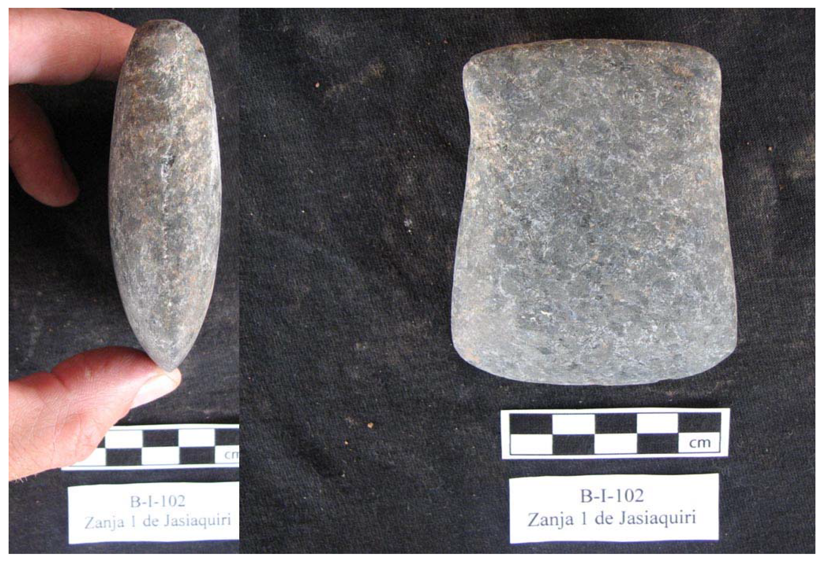
The builders felled trees with stone axes (
Figure 4), and probably cleared the small vegetation by burning and with traditional machetes made of hard polished wood [
14,
66]. Although other means of removing trees were possible (cutting or burning of the outer layers to gradually kill the tree), the threat of attack probably drove the builders to cut rather than slowly kill trees for removal. In addition to the initial clearing, the open area within and around ring ditches would have to be maintained by regular burning, and clearing, and stump removal.
Figure 4.
Pre-Columbian stone ax from surface collections at the ring ditch of Jasiaquiri, Baures, Bolivia.
Figure 4.
Pre-Columbian stone ax from surface collections at the ring ditch of Jasiaquiri, Baures, Bolivia.
Experiments demonstrate that stone axes are not as efficient as metal axes for cutting trees. Denevan [
67] summarizes a number of studies of native peoples clearing forest with stone and steel axes. Stone to steel efficiency ratios range from 10:1 for a 15.2 cm diameter tree to a ratio of 32:1 for a 121.9 cm diameter tree. The efficiency rate declines exponentially with thicker and harder wood trees to an efficiency ratio could be as low as 60:1. In Carneiro’s experiment, 0.69ha of trees of different size and hardness in a “primary forest” took 1,229 person-hours or 246 person-days (5 hour day) to clear with a stone axe (compared to 64 person-hours with a steel axe or a ratio of 19:1 [
67]. Converting this figure to a hectare, the labor is 1,883 person-hours or 377 person-days. Based on Carneiro’s figures, the labor for clearing of trees of the large ring ditch of Chipeno 3 is estimated be 29,714 person-days for the area of ring ditch and 42,556 person-days for area of ring ditch and a 100m buffer zone (
Table 3). In the case of a small ring ditch such as Veremos 2, the labor for clearing of trees is estimated be 1,921 person-days for the area of ring ditch and 9,038 person-days for area of ring ditch and a 100 m buffer zone (
Table 3). While the labor required clearing of trees within the area of a small ring ditch is relatively low, adding the buffer zone increases the labor considerably (more than 5 fold).
Table 3.
Labor necessary for clearing primary forest for ring ditch construction.
Table 3.
Labor necessary for clearing primary forest for ring ditch construction.
| Name | Area 1 (ha)a | Labor 1
(person-hours)b,c | Labor 1 (person-days)d | Area 2 (ha)e | Labor 2
(person-hours)f | Labor 2
(person-days) |
|---|
| Zanja 3 Chipeno | 78.9 | 148,569 | 29,714 | 113 | 212,779 | 42,556 |
| Zanja 2 Veremos | 5.1 | 9,603 | 1,921 | 24 | 45,192 | 9,038 |
After clearing the forest, the builders probably used fire hardened and sharpened digging sticks to break up soil and rock and baskets or carrying cloths to move the earth (
Figure 5). Ladders, rope hoists, or ramps were necessary for the construction the deep ditches with vertical walls. Many ring ditches are built over a substrate of rock. In many cases, the last 0.5 to 1 m of the 3–5m deep ditch was cut into rock that required considerable extra labor for the project. Based on detailed mapping of the footprints and profiles of ring ditches, estimates of the volume of earth removed are possible [
18]. Construction of small ring ditches such as Veremos 2 with a circumference of 845m and excavated profile area of 11 m
2 involved the movement of 9,295 m
3 of earth resulting in 3,718 person days of labor (
Table 4). Larger ring ditches such as Chipeno 3 with a circumference of 3,430m and excavated profile area of 11.7 m
2 involved the movement of 37,730m
3 of earth that required 15,092 person-days of labor (
Table 4). Many large ring ditches are composed of multiple concentric ditches that increase labor costs dramatically.
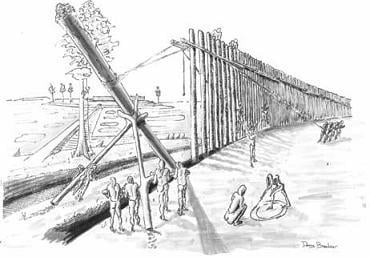
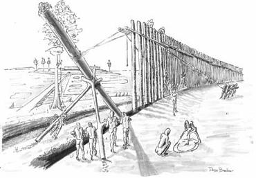
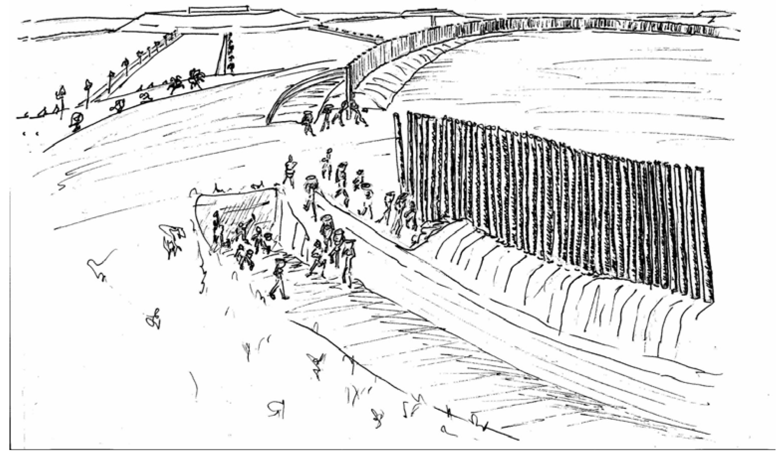
Figure 5.
Excavation and construction of palisade of a pre-Columbian ring ditch (artwork by Danny Brashear).
Figure 5.
Excavation and construction of palisade of a pre-Columbian ring ditch (artwork by Danny Brashear).
Table 4.
Labor necessary for excavating ditches during ring ditch construction.
Table 4.
Labor necessary for excavating ditches during ring ditch construction.
| Name | Circumference (m) | Area (m2) [ha] | Area of Ditch Profile (m2) a | Volume of Earth Moved (m3)b | Person-Daysc |
|---|
| Zanja 3 Chipeno | 3,430 | 789,752 [78.9] | 11.7 | 37,730 | 15,092 |
| Zanja 2 Veremos | 845 | 50,807 [5.1] | 11 | 9,295 | 3,718 |
Combining the labor of clearing the forest plus a 100 buffer zone and digging the ditches, a large ring ditch such as Chipeno 3 required 57,648 person-days. If a community had 500 adult laborers, the construction could have been completed in 115 days. Carneiro’s calculations of labor are based on experiments in clearing primary forest. The labor figures would probably be considerably lower if secondary forest was present, a likely scenario.
5. Ring Ditches as Defensive Earthworks
Scholars agree that a plausible function of the ring ditch was as a defensive structure to protect forest island inhabitants against attack (
Figure 6). Based on historical documents from the Colonial period and some archaeological research, war may have been endemic in the Baures region during late prehistory [
17,
39,
41,
42,
43,
45] and throughout much of lowland South America [
23,
44,
68,
69]. Scholars debate whether hostilities were driven by indigenous “tribal warfare” or European colonial world systems impinging on native societies, often far from the Colonial frontier, or both [
64,
70,
71]. The dating of ring ditches suggests that indigenous warfare was present before European contact.
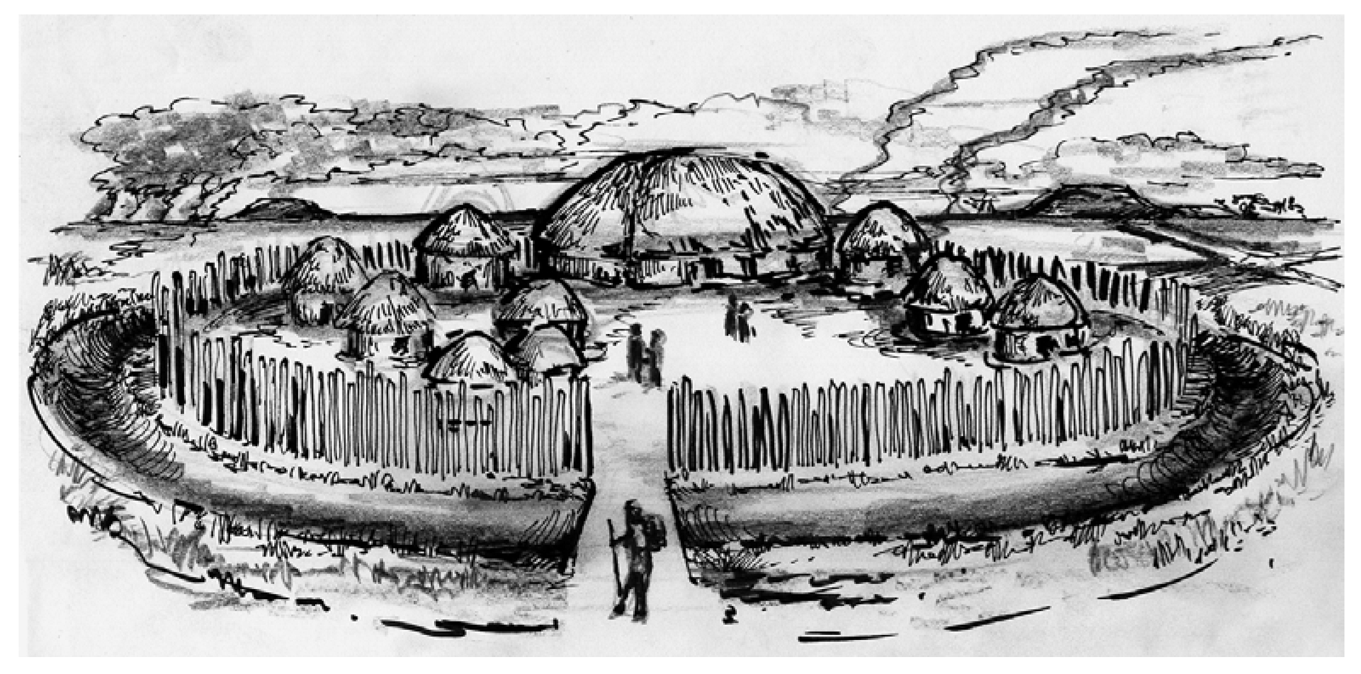
Figure 6.
Artist’s reconstruction of a small ring ditch with village and palisade wall (artwork by Daniel Brinkmeier).
Figure 6.
Artist’s reconstruction of a small ring ditch with village and palisade wall (artwork by Daniel Brinkmeier).
5.1. Chroniclers’ Accounts of Ditches and Palisades
The earliest reports of ring ditches in Amazonia are from Jesuit missionaries stationed in the Baures region and European soldiers penetrating the Parana and Paraguay river drainages. The oldest account from Baures is an anonymous report from before 1743 recounting the martyrdom of the Jesuit father, Barace. The account quotes a poet who lived and died in the region who provides a cryptic statement: “…and favor strongly of the encircling rine” [
72]. In a footnote, the author explains that “Rine signifies a ditch, about nine Foot wide, the Commonsense Boundary of Lands in this Moor, there being no hedges in it. These Rines are generally full of water” [
83]. Here, the author may be referring to ring ditches, especially those that bisect forest islands or causeways and canals crossing the savannas. Endemic warfare for slaves and sacrifices also is stressed in the account. Eder, the priest of the remote mission of San Martin where the San Martin and San Simon rivers join northeast of the Baures Hydraulic Complex between 1753 and 1768, points out that the inhabitants had been terrorized for years by the Guarayo, a Guarani speaking group to the south. According to Eder, the Baure responded to the threat in two ways:
Having terrorized the entire region, the Guarayo received the Baure promise to deliver each year a certain number of boys and girls, but that does not stop their frequent and unwelcome attacks. Thus, to resolve their problems in another way, they decided to surround their islands with ditches (that can be seen today and show the large population that had been there). I know of islands whose circumference reaches three miles (5.4 km) that were surrounded by two or three ditches. These are so wide and deep that they can be compared to those of Europe. They pile the excavated earth at the edges of the ditch, creating a very steep wall which is difficult for humans to cross. In this way, they make enemy assaults more difficult.
The anonymous account also highlights the dense population and well laid out population centers, some of which were fortified and surrounded by pitfalls and traps on paths:
But the most important discovery, and which gave Father Cipriano great pleasure was that of the Baures. These people are more civilized than the Moxos. They have a great Number of Villages, in which are Streets, and a fort of Squares, where soldiers exercise. Every Village is surrounded with a strong Palisade, which secures it from the Weapons of War employed in that Country. They set up a kind of Traps in the Highways, which stop their Enemies on a sudden. They use, in Battle, a type of Shield, made of Canes interwoven one with another, which are Proof against Arrows, and cover’d with Cotton and Feathers of various Colors.
The planned built environment of Baure settlements is also stressed by Altamirano who states that “towns were well designed, dominated by their plazas” [
75] and Orellana adds that “each town is surrounded by a well constructed palisade as defense again the weapons used in this region” [
76]. Based on the 75 villages of the Baure recorded by Barace in 1692 [
77] and the 124 villages reported twenty years later totaling 40,000 people [
78], ring ditches must have been numerous.
The chroniclers’ accounts of fortifications in the Baures region do not give details about palisade wall construction and form, but fortunately, Schmidel [
24] provides useful information about the fortifications used by the Guarani and the other ethnic groups that they preyed upon during the early Colonial period (1534–1554). Schmidel describes the city of Lambaré of the Carios, a nation of Guarani that established fortified cities, villages, and towns on bluffs overlooking rivers of the Kiodellaplata:
This settlement is surrounded or circled by two palisades and each post is a thick as a man at the waist; and one palisade is separated from the other by a space of twelve paces and the posts are buried in the earth a good fathom (braza or 1.67 m) and are above the earth almost as high as a man can reach with a large sword (tizona or 103 cm). In addition, the Carios have their moats and made pits located fifteen paces from the wall or palisade excavated to a depth equal to the height of 3 persons. Inside, they embedded a lance of hard wood that is as sharp and pointed as a pin. These pits were covered with grass and small branches from the forest and covered with some soil and plants…”.
In another section, Schmidel compares the posts with the width of a man and a half at the waist (estimated as 42 cm), buried the height of a man (estimated as 1.67m), and standing three fathoms (4.91 m) [
80]. The document clearly shows the association of multiple palisades with encircling ditches and pitfalls.
Illustrations for Schmidel’s account show Europeans and their native mercenaries attaching a settlement with double palisade walls surrounded by a single ditch with 3 small “bridges” of wood or earth spanning the excavation [
81]. Another figure depicts a Carios fortified town with double palisade walls. The gaps that are shown between the posts in the palisades of both towns are probably artistic convention to show the interior rather than a structural feature for saving wood or firing arrows. The landscapes around fortified towns in the images are open spaces. The text discusses small patches of forest used for refuge by the Spanish and their enemies.
In describing Tupinamba defensive works along the Southern Atlantic Coast of Brazil, Hans Staden states, “The savages had made two forts out of thick trees” [
82] and “They built their fortifications out of great, long sticks placed around their huts, just like a fence around a garden. They built this for protection against their enemies” [
83].
Staden continues in more detail:
Few of their villages have more than seven huts. They leave a square place between the huts; there they slay their captives. They also tend to build fortifications around their huts as follows: They make a palisade fence out of palm trees, which they (first) split. This palisade fence is about one and a half fathoms high. They build it so thickly that no arrow can pierce it and leave little holes through which they can shoot. Surrounding this palisade fence, they build another fence out of big, high poles, which they do not place right next to each other, but only so close that a man cannot creep through. Several (groups) among them have the custom of spiking the heads of those, whom they have eaten, on the palisade fence in front of the entrance to the huts.
Similar to the Guarani, the Tupinamba combined palisades with sharpened stakes (although not embedded in the base of pits and trenches) and surrounded these with dense stands of thorny shrubs to protect frontier settlements from enemies and jaguars [
85].
Although simple and stylized, the Staden’s images show square and round palisade settlements of the Tupinamba and their enemies. The upright posts were made of large tree trunks reinforced with smaller logs lashed perpendicular near the top of the uprights with angled logs as internal buttresses [
86]. Like the Guarani, some Tupinamba villages were protected by two concentric palisades separated by a small space. Staden also depicts an open landscape covered with tree trunks around these settlements, probably the source of palisade wood and at the same time providing lines of sight for firing and observation [
87]. In the image of the town of Garasu (Igaracu), Staden shows three palisades in close proximity. The Tupinamba palisade villages lack the ditches of the Guarani. In the most detailed drawing and text, the palisades (“1.5 fathoms” or 2.5 m tall) consisted of an inner wall of split palms tightly placed and an outer wall of tree trunks with small spaces between them (less than 31 cm) to prevent enemies from slipping through. Although no depth for post interment is provided, I expect placement similar to those described by Schmidel.
5.2. Palisade Construction
We have no archaeological evidence of palisades associated with ring ditches in the Baures region due to limited excavations of these earthworks. Based on the Colonial period descriptions and to be most effective for defense, palisades were constructed on top of the inside berm created by the excavation of the ring ditch. Palisades would be more effective, intimidating, and aesthetically pleasing if all posts were of similar diameter, length, hardness, and resistance to decay.
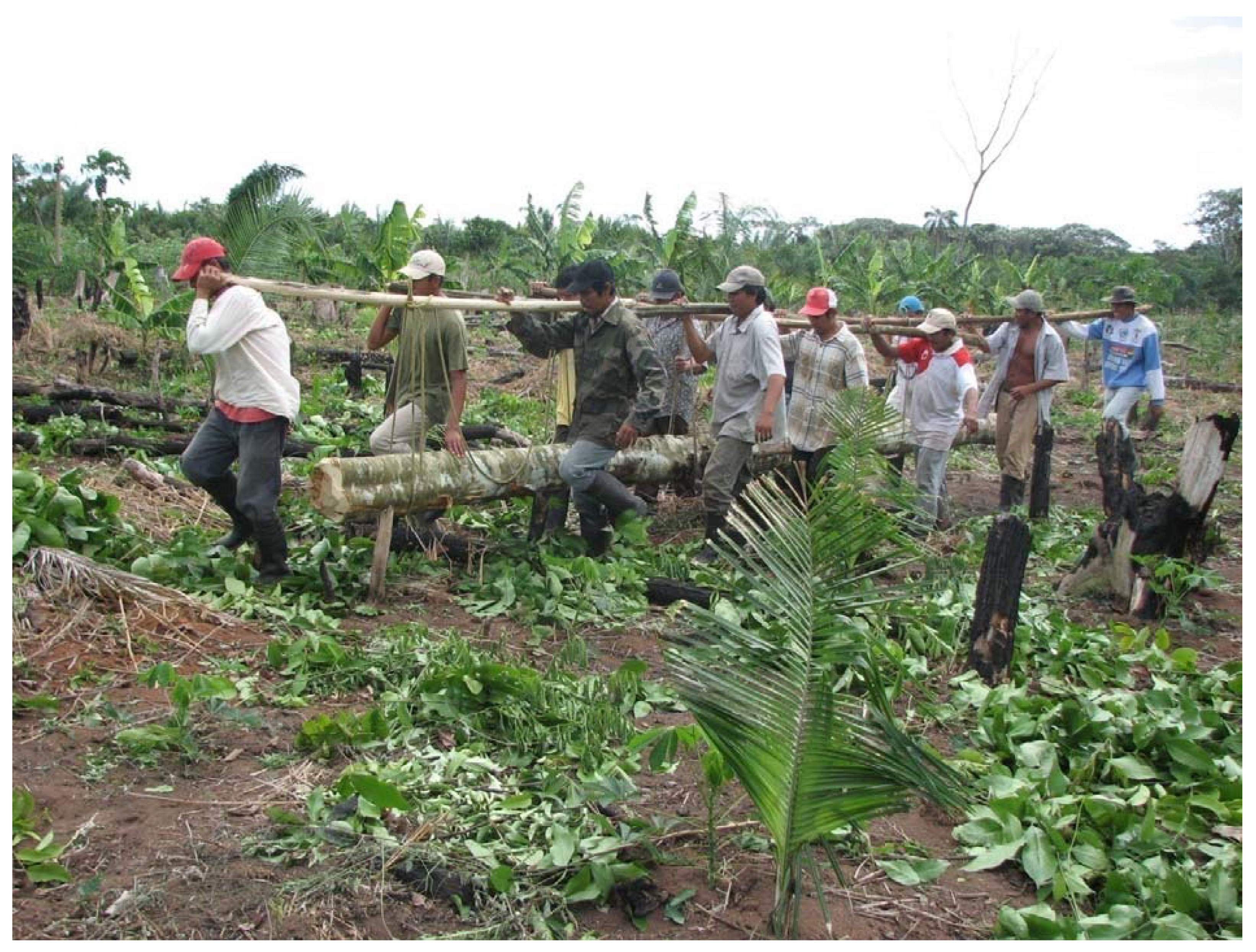
In addition to cutting the forest on the construction site, the trunks had to be moved into place as palisade posts. In the community of Alta Gracia in 2007, a team of 12 men using a rope under the log and across their shoulders carried a hardwood trunk of 30 cm diameter and 8 m long several kilometers (
Figure 7). Larger logs were probably rolled or dragged by large teams with elaborate rope harnesses. During the wet season, logs could have been floated in rivers and the flooded savannas to their desired location. The labor of cutting and trimming of long tree trunks into multiple posts would be similar to or great than that calculated for forest clearance (
Table 3). In addition to labor for clearing the construction site, cutting trunks into posts, and moving posts into place, excavators needed deep wall trenches of 1.5m depth and enough width (1 m) to work for installing posts.
Figure 7.
Moving a tree trunk from forest to building site, Alta Gracia, Baures, Bolivia.
Figure 7.
Moving a tree trunk from forest to building site, Alta Gracia, Baures, Bolivia.
To estimate of the number of trees necessary for enclosing a small and a large ring ditch with palisades, I use trees measuring 25 cm DBH, typical trunks of secondary forests that would have been easier to fell with stone axes, and 37 cm DBH trunks, the average diameter calculated from the average of each measured class of > 10 cm DBH trees in the primary forest of La Chonta [
88] and more closely matching the descriptions of palisade posts of the Guarani (as “thick as a man” and as wide as “man and a half at the waist”). The average trees in secondary or managed forest have smaller diameters, grow more rapidly to harvestable size for palisade posts, and are easier to fell with stone axes and transport to the construction sites. On the other hand, large, tall straight trees from primary forest produce more usable posts per trunk and may be more resistant to decay.
I assume that these posts were installed side by side with minimal or no gaps. The Colonial period descriptions of ring ditches in the Baures region describe retractable bridges across the ditches, doorways, gates, and baffled or irregular narrow corridors to control access. Although palisade heights are not given in the chronicles for Baures, Schmidt’s eyewitness descriptions of Guarani palisades, thick tree trunks were buried 1.67 m below the ground and stood 2.73 m above the ground or a total length of 4.4 m. In a second account, posts were buried 1.67m deep and towered 4.91 m above the surface or a total length of 6.58 m [89]. I use 5.5 m for palisade post length for the calculations of trees used for ring ditch palisades in Baures (
Figure 8).
Figure 8.
Construction of a palisade of wood inside a ring ditch (Artwork by Danny Brashear).
Figure 8.
Construction of a palisade of wood inside a ring ditch (Artwork by Danny Brashear).
Tropical Forest canopies in the Bolivian Amazon can reach 30 m and emergent trees as high as 45 m [
42]. Thus, an individual tree could provide multiple palisade posts of sufficient length and diameter, although an inverse relationship exists between height above ground and tree diameter. In terms of relatively straight trunk, the measurement of height to first branch (“commercial height”) is useful for determining how many posts could be cut from a single, straight tree trunk. Because of the lack of straightness, tree branches were probably not used for palisade construction. Because the wide tapering tropical forest tree buttresses would difficult to cut with stone axe and relatively worthless for palisade posts; the usable actual usable height to first branch for many trees probably is shorter. The average of the height to first branch reported for La Chonta of 9.45 m are useful approximations [
88]. Based on averaged measurements for Schmidt’s Guarani palisades (5.5 m), I will assume that 2 posts could be cut from a single tree trunk of 25 and 37cm diameters.
For a palisade of a small ring ditch such as Veremos 2, 3,380 posts of 25 cm in diameter representing 1,690 trees or 2,284 posts of 37cm in diameter representing 1,142 trees would be necessary (
Table 5). For a palisade of a large ring ditch such as Chipeno 3, 13,720 posts of 25cm in diameter representing 6,860 trees or 9,270 posts of 37cm in diameter representing 4,635 trees would be necessary (
Table 5).
Table 5.
Requirements for palisade ponstruction (assuming 25 cm diameter posts and 37 cm diameter posts).
Table 5.
Requirements for palisade ponstruction (assuming 25 cm diameter posts and 37 cm diameter posts).
| Name | Circumference (m) | Number of Posts (25 cm diameter) a, b | Number of Trees (25 cm diameter)c | Number of Posts (37 cm diameter)d | Number of Trees (37 cm diameter) |
|---|
| Zanja 3 Chipeno | 3,430 | 13,720 | 6,860 | 9,270 | 4,635 |
| Zanja 2 Veremos | 845 | 3,380 | 1,690 | 2,284 | 1,142 |
Did the area of initial forest clearance for the construction of ring ditches provide all the necessary wood for palisade construction or was additional deforestation necessary? The number of trees calculated for forest clearance (
Table 6 and
Table 7) is compared to the trees required for palisade construction (
Table 8 and
Table 9). The figures demonstrate that the clearing of primary forest for construction of ring ditches produced more usable wood than was necessary to encircle the earthworks with a single palisade.
Table 6.
Posts Available for palisade construction from clearing ring ditch based on basal area (assuming 25 cm diameter posts and 37 cm diameter posts).
Table 6.
Posts Available for palisade construction from clearing ring ditch based on basal area (assuming 25 cm diameter posts and 37 cm diameter posts).
| Name | Circumference (m)a | area (m2) [ha]a | Basal Area 1 (m2) b | Number of Posts (25 cm) c, d | Number of Trees (25 cm) e | Number of Posts (37 cm) f | Number of Trees (37 cm) |
|---|
| Zanja 3 Chipeno | 3,430 | 789,752 [78.9] | 2,187.897 | 44,651 | 22,326 | 20,353 | 10,177 |
| Zanja 2 Veremos | 845 | 50,807 [5.1] | 141.423 | 2,886 | 1,443 | 1,316 | 658 |
Table 7.
Posts Available for palisade construction from clearing ring ditch plus 100 m buffer zone (assuming 25 cm diameter posts and 37 cm diameter posts).
Table 7.
Posts Available for palisade construction from clearing ring ditch plus 100 m buffer zone (assuming 25 cm diameter posts and 37 cm diameter posts).
| Name | Circumference (m) | Area (ha)a | Basal Area 1 (m2) | Number of Posts (25 cm) | Number of Trees (25 cm) | Number of Posts (37 cm) | Number of Trees (37 cm) |
|---|
| Zanja 3 Chipeno | 3,430 | 113 | 3,136.263 | 64,005 | 32,003 | 29,175 | 14,587 |
| Zanja 2 Veremos | 845 | 24 | 665.52 | 13,582 | 6,791 | 6,191 | 3,095 |
Table 8.
Surplus of trees removed in ring ditch construction and trees after palisade construction.
Table 8.
Surplus of trees removed in ring ditch construction and trees after palisade construction.
| Name | Area (ha)a | Trees available b | Trees needed for Palisade (25 cm) | Surplus 1 | Trees needed for Palisade (37 cm) | Surplus 2 |
|---|
| Zanja 3 Chipeno | 78.9 | 35,347 | 6,860 | 28,487 | 4,635 | 30,712 |
| Zanja 2 Veremos | 5.1 | 2,285 | 1,690 | 595 | 1,142 | 1,138 |
Table 9.
Surplus of trees removed in ring ditch construction including 100 m buffer zone and trees after palisade construction.
Table 9.
Surplus of trees removed in ring ditch construction including 100 m buffer zone and trees after palisade construction.
| Name | Area (ha)a | Trees available b | Trees needed for Palisade (25 cm) | Surplus 3 | Trees needed for Palisade (37 cm) | Surplus 4 |
|---|
| Zanja 3 Chipeno | 113 | 50,668.8 | 6,860 | 43,808.8 | 4,635 | 39,173.8 |
| Zanja 2 Veremos | 24 | 10,752 | 1,690 | 9,062 | 1,142 | 7,920 |
What happened to the extra wood? A number of ring ditch complexes have widely separated double and triple concentric ring ditches. Although each could have had a separate palisade, multiple ditches may represent an expansion over time as needs changed rather than simultaneous use as palisades; thus, only the outer most ring ditch was assumed to be walled. The Guarani and Tupinamba had 2–3 closely spaced, concentric palisade walls that would double or triple the number of trees needed [
23,
24]. In the drawings of Staden [
23], additional tree trunks and branches were used for cross-bracing, buttresses, and secondary palisades of the Tupinamba. In addition to use in palisades, the large settlements described by the chroniclers would have required large quantities of beams and posts for houses, palms for thatch, fiber, tools, and food, firewood, and large hardwood logs for canoes.
Because tall upright posts were interred an estimated 1.5 m in warm and seasonally humid soils, underground sections of palisades were subject to rapid decay. In the humid Amazon, fence posts need to be replaced every 4–5 years due to termite damage and decay [
90]. Certain wood available locally such as tajibo (
Tabebuia sp.) resist decay and could last longer. I estimate that replacement was necessary every 10–15 years. If more trees were harvested in clearing primary forest for ring ditches than were necessary for the original palisade, some posts could have been stockpiled for future use. If original posts were of sufficient length, the decayed bases could be trimmed and the posts reinstalled; otherwise, new posts would be necessary. Ruined posts were probably also recycled as firewood reducing demands on standing forest. The decay of palisade posts in this humid environment outpaced growth of new forest to replace them. The environment of the Baures region provides certain advantages for moving logs from distant forests. During the wet season, materials could be transported across inundated savannas in the numerous artificial canals and along the numerous north-south rivers.
The estimates above assume the existence of a primary “undisturbed” forest before the construction of ring ditches. On the other hand, the large farming communities that required protection from their enemies were living on the same forest islands; thus, the landscape probably was more open with smaller stands of secondary managed forest due to settlement, gardens, and fields. In this case, a smaller number of surplus trees would have been available.
Living walls of impenetrable vegetation may have been an efficient and sustainable alternative to wooden post palisades [
35,
36,
37,
38,
39,
40,
41,
42,
43,
44]. One early account from Baures mentions the planting of dense impenetrable walls of a tall spiny plant (sorocoro), combined with water-filled ditches for defense and labyrthinth-like entrances to protect villages [
35]. Many neotropical trees (57 species used by for Costa Rican farmers) make excellent living fences, often impenetrable by humans and animals once established [
90,
91,
92]. The best are common disturbed habitat species that thrive in open spaces by either taking root from stem cutting or transplanted as seedlings. Chacón León and Harvey [
93] also point out that living fences play an important ecological role in creating refuges and corridors for the maintenance of biodiversity in heavily farmed landscapes. Certain tree species used as original posts in palisade construction may have taken root once in place and over time lessened the need to replace rotten posts.
The use of living walls in the place of palisades has some limitations. These features would be less effective than palisades in blocking arrows, spears, and darts used by attackers. If living walls surrounded ring ditches, patterned signatures of the species that were planted and maintained on the larger earthworks may exist. We often encountered dense patches of spiny plants and lianas near the pre-Columbian ring ditches deep in forest, far from the ecotone between forest and savanna where the plant thrives today. These plants would be useful in repelling people and animals, but offer little protection against projectiles such as arrows, spears, darts, or stones.
6. Ring Ditches and Historical Ecology
In our surveys, most medium to large (>2 km
2) forest islands surveyed in the Baures region have a ring ditch and many have multiple earthworks. Based on this sample, we can expect to find ring ditches on most of the 80 unsurveyed forest islands in the Baures region. The construction of ring ditches removed 2,000 to 11,000 trees (with the range based on whether or not a buffer zone is included) for small ring ditches and 35,000 to 50,000 (with the range based on whether or not a buffer zone is included) for large earthworks. In the process, an estimated 400–5,000 Mg/ha for small earthworks and 6,000–21,000 Mg/ha of tree biomass for large earthworks (
Table 2). The short term result was deforestation in the form of clear cutting. If a wide field of visibility was required for fire zones and surveillance or simply to show off the monumental earthworks (buffer zone), the spaces were probably kept clear of forest for decades or centuries. One result was the removal and replacement of “natural” vegetation with anthropogenic biota (economically useful and aesthetically pleasing species to the Baure). Because humans exploited these forest islands for settlement, farming, hunting, and agroforestry for centuries, if not millennia before the ring ditch phenomenon, the forests removed probably were not pristine, original, or natural.
The total area footprint of complete ring ditches mapped by our project is 715 ha or 7.15 km2 (excluding the 100 m buffer zone). If the entire Baures region under consideration originally was covered by forest, impact of trees removed for ring ditch construction is relatively insignificant. Because forest islands only occupy approximately 20% of the savanna and wetland dominated landscape, the impact of tree removal is substantial. In addition to the scale of individual earthworks, the number and spacing of ring ditches on forest islands and the size of individual forest islands must be considered to understand the overall environmental impact. Small ring ditches on medium to large forest islands probably had much less impact than forest islands with multiple ring ditches such as Altagracia, Cerro Mercedes, Buen Retiro, and Orobayaya.
The construction and use of ring ditches were large scale and intense levels of heterogeneous disturbances. These earthworks may have created large swaths of deforestation across forest islands. The sequential construction of multiple concentric ring ditches indicate that the ring ditches expanded through time as population increased and needs changed.
Although better drained than the savannas, the forest islands of Baures are classified as relatively low fertility because of iron oxide and manganese nodules, frequent aluminum toxicity, acidic to neutral pH, and thin soils derived from the Precambrian [Brazilian] Shield substrate [
94]. Soil horizons were disturbed to a depth of up to 4.5 m through the excavation of ditches, raising of berms, and digging of wall trenches for palisades. Deep subsoil was churned to the surface and mixed with topsoil in the process. Stump removal over the entire cleared surface would expand the scale anthropogenic mixing of soils. If ring ditches surrounded permanent settlements, human occupation probably enhanced of soils by contributing large amounts of organic matter from food processing and discard, human wastes, house thatch and post decay, burials, agricultural soil amendments [
15,
63]. The original relatively flat surface of forest islands was transformed into a complex topography of ridges and swales through ditch excavation and berm creation (
Figure 2 and
Figure 3). By altering drainage, ring ditch construction created permanently moist conditions in the ditches and drier conditions on the berms. In addition to reducing biodiversity in the short term, the clearing of large swaths of forest increased albedo, raised temperatures, reduced humidity, and changed disease vectors. Biological inventories planned for the future will probably document the presence of economic species that have been moved and/or transplanted from distant habitats to these locations by humans, colonization by species adapted to human disturbances, and oligarchic forest stands (see below).
The lack of detailed chronology for ring ditch construction, use, and abandonment raises an important question. Were ring ditches in use contemporaneously or sequentially? Each scenario implies different temporal and spatial scales of impacts on the local and regional environment. The large populations reported by early Spanish explorers and priests could account for the large number of defensive ring ditches documented and suggest that these earthworks are roughly contemporaneous. On the other hand, the existence of multiple concentric ring ditches suggests an evolution of individual earthwork complexes over time as population expanded and their needs changed. The limited archaeological dating suggests that the ring ditches are a late prehistoric or protohistoric phenomenon in the Bolivian Amazon [
18,
56,
57,
58,
95], post AD 1300 in the State of Acre [
20], and AD 1250–1650 in Upper Xingu river region [
64].
Because the Baures region was brought under Spanish control much later than other areas of the Bolivian Amazon (1704), the arrival of diseases and exploitation that wiped out indigenous societies throughout the region was delayed. Despite the resettlement of the Baure into Jesuit mission towns, the more remote forest islands remained populated by scattered groups of other ethnic groups that resisted Spanish authority. Although the ring ditches fell out of use as the region was pacified, native peoples still occupied remote forest islands during this time of transition. Their continued activities provided cultural mechanisms that helped determine the paths of reforestation determining forest structure, composition, and diversity.
During our surveys, I noted a correlation between ring ditches and large dense stands of chocolate (
Theobroma cacao) ([
18]. Estimates 5,700 ha of chocolate were reported for 20,900 ha of forest island surface near the town of Baures [
94]. Most scholars attribute the presence of chocolate in the region to the Jesuit who introduced the domesticated tree from Mesoamerica as a cash crop for their missions. The association between chocolate and ring ditches, especially those located far from the missions, may predate the Jesuits (
Figure 9). Today, the local inhabitants refer to these chocolate stands as “wild” or “Jesuit” and while protected and harvested annually, the forests receive little attention or maintenance to ensure future production. In this case, the original vegetation that is assumed to be diverse primary forest was completely removed for construction and maintenance of the ring ditches. After the ring ditches fell out of use, a monoculture crop was established which still thrives today as an important resource and prominent signature of historical ecology. An alternative explanation would be that chocolate was so valuable that the pre-Columbian inhabitants constructed earthworks to define its space of cultivation as special. Local inhabitants also have considerable success hunting the game attracted to these fruits and other stands of nut and fruit trees associated with ring ditches.
Figure 9.
Ring ditch in a dense stand of chocolate on the forest island of Catiene, Baures, Bolivia.
Figure 9.
Ring ditch in a dense stand of chocolate on the forest island of Catiene, Baures, Bolivia.
Over centuries, the generation of large amounts of organic matter by large permanent settlements, soil amendments for intensive agriculture on forest islands and in raised fields in the savanna, regular heterogeneous disturbances of various scales, and the establishment of agro-diversity within gardens, fields, and orchards, the culling of certain trees for palisades (e.g., tall straight trees with dense wood) and encouragement of economic species used for fibers, thatch, food, and fuel would significantly alter forest structure and composition, paths of species turnover, biomass, and overall diversity on and around ring ditches.
Did the construction of ring ditches reduce biodiversity and result in environmental degradation? The answer depends on and a baseline for comparison and the scale observed. We do not have benchmarks of pristine “untouched” nature for comparison, despite the assumptions of some scholars that pristine nature exists somewhere in the Neotropics. In terms of alpha biodiversity, diversity was reduced in the short term due to deforestation to prepare for construction and timber used for palisade walls. In contrast, the creation of large anthropogenic disturbances with sharp boundaries with other ecosystems (savanna, wetland, and standing forest) may have increased beta biodiversity through ecotone creation and maintenance and larger scale contrasting patches of vegetation.
The competing demands of agriculture and settlement versus ring ditches on the standing forest of forest islands were intense in late prehistory. One solution may have been to harvest usable timber for palisade posts from forests cleared for new fields. In slash and burn agriculture, drying and burning of the downed vegetation is critical. In Baures, most of the large diameter trunks remain in the field after the burn and are eventually cut and used for firewood over the 2–3 years of use. This wood could have been diverted to palisades. My calculations show that the clearing of primary forest for ring ditches produced more wood than was necessary for palisade construction, which could be dedicated to other domestic needs. When not being used for defense and other proposed functions, crops may have been grown in the open spaces inside and outside ring ditches. Knowing the needs for maintenance of existing palisades and future expansion of defensive structures, did the inhabitants of the Baures region manage forests for a sustainable harvest of trees for palisade posts? Based on the Colonial documents about continuous raiding and attacks of settlements before the arrival of Europeans, native peoples that were originally dispersed on forest islands across the landscape in hamlets and villages may have resettled in larger, centralized defendable settlements and abandoned their previous homes on outlying forest islands. Over time, these old settlements and farms became managed resources for hunting, gathering, and wood for palisades.
Protracted war can have a profound negative impact on the environment. Civil unrest, battlefields, destruction of settlements, property, and subsistence base, and forced migration often result in reduced biodiversity and degraded environmental health. On the other hand, loss of life, depopulation of buffer zones or “no man’s lands,” abandonment of much of the countryside in favor of more defendable, centralized settlements encourage new forest growth in previously cleared areas, possibly increasing biodiversity.
7. Conclusions
In late prehistory, protohistory, and possibly into the Colonial period, the pre-Columbian inhabitants of the Baures region undertook massive transformation of the regional savannas, wetlands, and forest islands through farming, transportation and communication infrastructure, agroforestry, fish farming, and earthwork construction. In the early eyewitness accounts, ring ditches/palisades, indigenous settlements ranging from large central towns to hamlets, and farms occupied most forest islands [
27,
31,
37]. As the only dry terrain for many months of the year, competition for space on forest islands for settlement, agriculture, agro-forestry, and defense increased as populations increased in late prehistory. The construction and maintenance of ring ditches, whether for defense, public spaces, cemeteries, elite residences, and/or settlement would have required clear cutting of large areas of forest islands. As monumental built environment, the earthworks were intended to be displayed as symbols of community pride, labor mobilization, aesthetics, engineering, and power. For these functions, large areas outside the ditch also were cleared of forest similar to the lines of sight for surveillance and open fire zones as defensive works. Based on archaeological and historical documentation, human populations were large and the non-flooded landscape was densely settled and farmed. In addition to enormous forest resources removed and consumed for defense, the inhabitants harvested trees for houses, canoes, and firewood.
Forest islands make up approximately 20% of the cultural landscape of the Baures region. Because of the limited dry high ground for ring ditches, settlement, and farming, forest islands were largely deforested in late prehistory (
Figure 10). As more forest island space was converted to defensive earthworks over time, areas dedicated to fields, gardens, orchards, hunting, and collecting needed to support the large population may have been reduced. The establishment of small blocks of raised fields in the savannas adjacent to concentrations of ring ditches on forest islands in Orobayaya and Magdalena may have been a response to this land pressure.
Figure 10.
Nine complete ring ditches (tan) and incomplete ditches (red dots) of Altagracia forest island (lime green) within the savanna (red-pink) near the town of Baures, Bolivia (white grid in lower left).
Figure 10.
Nine complete ring ditches (tan) and incomplete ditches (red dots) of Altagracia forest island (lime green) within the savanna (red-pink) near the town of Baures, Bolivia (white grid in lower left).
The societies whose activities determined the present day landscapes lived in dense, large thriving settlements. The archaeological evidence suggests that their lifeways were sustainable, despite endemic warfare in the late prehistoric, protohistoric, and early Colonial periods. The rapid collapse of these indigenous societies was due introduced diseases, reorganization of settlement and farming, mission and colonial policies, endemic raiding by the Portuguese, and exploitation by secular and religious authorities during the Colonial period rather than environmental degradation or climatic change. As a result, large areas of the region remain unpopulated and relatively untouched by modern activities. Today, population is concentrated in settlements on the large forest islands near navigable rivers. In contrast to the more permanent, intensive field agriculture in the past, most contemporary farmers practice slash and burn agriculture and rely on access to primary and secondary forest near settlements for rotating their fields.
Because of these events and circumstances, the Baures region is ideal for studying the complex ecological history of cultural landscape formation through hundreds of years of occupation by a thriving indigenous society that heavily transformed the environment through earthwork construction and other activities followed by a dramatic demographic collapse and nearly 500 years of abandonment of much of the region. Much of the savanna, maintained through systematic burning and complex networks of earthwork created for water and resource management in the past, are covered with Mauritia flexuosa and other woody species. Causeways, canals, and fish weirs criss-crossing the savannas and wetlands are now faint lines of trees and waterways choked with aquatic plants. Forest islands, large parts of which once lay bare for possibly centuries through clear cutting for defense, settlement, and fields are dense heterogeneous stands of biodiversity. Jaguars, predators high in the food chain, whose presence indicates a healthy ecosystem, roam the savannas and forest islands and caimans are common in rivers east of Baures.
Because of the valuable chocolate and other fruit, and palm stands, local communities protect and manage many forest islands. These same forests often are teaming with game that thrives on the same resources. For the residents of Bella Vista, forest resource extraction is a year-round activity that supports hundreds of families. Forest islands that are not under modern settlement, cultivation, and pasture have impressive biodiversity, so much so that large areas of the region are now protected and managed as biological reserves, indigenous territories, and archaeological parks (e.g., Departmental Park and Natural Area of Integrated Management of Iténez, the Itonamas and Baure Indigenous Territories, the Kenneth Lee Archaeological Park) [
96,
97]. Obviously, human disturbances such as massive deforestation to create ring ditches did not eliminate biodiversity and in the long term contextual perspective of historical ecology, may have enhanced diversity.
Was this simply the “recovery” or “rebound” of a resilient complex system, or the natural forest succession towards some ideal equilibrium of mature, primary forest? These explanations assume the existence of, and a return to, some optimal state of stasis and a benchmark of prehuman “pristine” environment existing somewhere for comparison. However, historical ecologists argue that ever since the first humans set foot in the Neotropics at the end of the Pleistocene, the environment has been impacted by native peoples, and as a result, no pristine wilderness exists [
14,
30,
98,
99]. While many natural scientists and conservationists assume that the remaining tropical forests with high biodiversity are untouched by humans, landscape archaeologists and historical ecologists find the signatures, both subtle and not-so-subtle, of long-term, patterned human activities imprinted on those landscapes. I have argued that native peoples domesticated the landscape [
15,
48]. Native peoples did not “adapt” to what some scientists argue was an environment characterized by limited resources for human development [
25], but rather, they created the world they desired through resource creation and management [
15,
48].
Returning to the issue of “why do some tropical forests have so many species of trees?” raised at the beginning of this article, Leigh and colleagues conclude, “To understand why some tropical forests have so many kinds of trees, we will have to learn more about the natural history of these trees, the history of their biomes, and the driving forces of tree evolution” [
100]. On the other hand, historical ecologists and landscape archaeologists insist that without a serious consideration of cultural history over the long term, intentional patterned human activities, and historical contingency at the local, regional, and biomes scales across short and long-term historical scales, we will never know. Scholars must abandon the idea of a pristine environment and that diversity is simply an ahistorical, “natural” process of evolution for a more holistic understanding that includes human agency, intentionality, and culture over the long term.


