Article

High Megabenthic Complexity and Vulnerability of a Mesophotic Rocky Shoal Support Its Inclusion in a Mediterranean MPA

1
Dipartimento di Scienze della Terra dell’Ambiente e della Vita (DISTAV), Università di Genova, Corso Europa 26, 16132 Genova, Italy
2
National Biodiversity Future Center (NBFC), 90100 Palermo, Italy
3
Consorzio Nazionale Interuniversitario per le Scienze del Mare (CONISMA), Piazzale Flaminio 9, 00196 Roma, Italy
4
Portofino Marine Protected Area, Viale Rainusso 1, 16038 Genoa, Italy
5
Institute for Environmental Protection and Research (ISPRA), Via V. Brancati 60, 00144 Roma, Italy
*
Author to whom correspondence should be addressed.
Diversity 2023, 15(8), 933; https://doi.org/10.3390/d15080933
Submission received: 21 June 2023 / Revised: 2 August 2023 / Accepted: 7 August 2023 / Published: 16 August 2023

Abstract

:
The deep shoal of Punta del Faro (Ligurian Sea, Mediterranean Sea) is a mesophotic rocky elevation hosting complex animal forests threatened by fishing activities. To identify appropriate conservation measures and set a reference example for similar cases, we present a detailed characterization of its megabenthic communities and a quantification of the fishing pressure. The results highlight the high natural value of the area, presenting high biodiversity (111 megabenthic and demersal species) and diverse types of animal forest, predominantly dominated by cnidarians. The tridimensional seascape is among the most complex in the eastern Ligurian Sea, but the long-term evaluation of its environmental status suggested consistent affects due to the high abundance of lost fishing gear (0.65 items m−2) directly entangled with structuring cnidarians. The artisanal and recreational fishing pressure are currently moderate. However, the use of bottom-contact fishing gear causes significant modifications to the seafloor’s integrity. This study emphasizes the high conservation value and vulnerability of the shoal, highlighting the importance of its protection through its inclusion in the Portofino MPA, whose external perimeter is 200 m from the study area. A critical discussion of the advantages and disadvantages is provided with a map of the possible extension of the MPA boundaries.

1. Introduction

The deep shoal of Punta del Faro is a rocky elevation located about 600 m SE of the Portofino Promontory (Ligurian Sea, Mediterranean Sea) and lying less than 200 m outside the boundaries of the Portofino Marine Protected Area (MPA) (Figure 1a). The shoal consists of NW–SE-orientated outcropping rocks at depths ranging from 63 m to 77 m and emerging from a gently sloping detritic bottom (Figure 1b).
Pioneering explorations of the shoal date back to the 1990s, when the deployment of the remotely operated vehicle (ROV) ROBY2 (Unità Operativa Veruggio, Istituto per l’Automazione Navale del CNR) allowed researchers to capture the first images of the main structuring species, including the black coral Antipathella subpinnata (Ellis & Solander, 1786) and the large hydrozoan Lytocarpia myriophyllum (Linnaeus, 1758) [1]. Later explorations, conducted in 1996 using an ROV and side-scan sonar, led to the first mapping of the main biocoenoses of the area, identified as (i) hard-bottom infralittoral biocoenoses (located along the vertical cliffs of the Portofino Promontory), (ii) coralligenous and deep hard-bottom biocoenoses, and (iii) circalittoral soft bottoms [2] (Figure 1c). These investigations confirmed the presence of distinct black coral facies on the shoal and reported the presence of a rich benthic community, consisting of 29 megabenthic taxa. In the last ten years, the development of new and more accessible ROV devices and technical diving procedures has facilitated the collection of additional detailed information on the mesophotic biocoenoses inhabiting the area of the Portofino Promontory [3,4,5,6]. Comprehensive ROV campaigns were conducted by the Istituto Superiore per la Ricerca e la Protezione Ambientale (ISPRA), Agenzia Regionale per la Protezione dell’Ambiente Ligure (ARPAL), and the University of Genoa in 2012, 2016, and 2020, respectively, reporting a dense forest of the gorgonian Eunicella cavolini (Koch, 1887) dominating the rocky elevation [6]. The black coral population was investigated by a series of multidisciplinary studies targeting A. subpinnata’s asexual reproduction [7], diet [8], associated microbiome [9], and genetic connectivity [10]. The detritic bottoms surrounding the shoal host dense meadows of the large hydroid L. myriophyllum [5], bryozoans, and serpulid tubes. Most of these biocoenoses are unique in the eastern Ligurian Sea, significantly increasing the natural value of the deep shoal of Punta del Faro.
Investigations using ROVs were also carried out to evaluate the anthropogenic impact on the seafloor in the Portofino area. A high abundance of seafloor litter was reported in this area (up to 2800 items ha−1), mainly represented by abandoned, lost, or otherwise discharged fishing gear (ALDFGs) [11]. These materials include lines, ropes, and post nets and are often observed entangling the delicate ramifications of structuring anthozoans. Cuts and abrasions lead to infections and necrosis, strongly reducing the fitness of colonies and the tridimensionality of habitats and compromising the integrity of the seafloor [12,13,14,15,16,17]. No information is available on the number of fishers exploiting the deep shoal of Punta del Faro. Quantitative data on the fishing effort in the area are scarce, only targeting the coastal sites enclosed within the MPA boundaries [18,19,20,21]. However, ROV explorations highlighted the significant pressure of artisanal and recreational fishing activities, indicating that adequate protection of its benthic biocoenoses is needed.
The present study aimed to collect essential information on the biocoenoses of the deep shoal of Punta del Faro, including (i) a comprehensive description of its megabenthic communities, including predictive habitat mapping, (ii) the assessment of its environmental status over eight years, and (iii) the quantification of the fishing-pressure burden on the shoal by means of interviews and ROV surveys. This information is essential for resource-management organizations to implement the best conservation measures. Here, we discuss the benefits of a putative enlargement of the Portofino MPA, leading to the inclusion of the deep shoal of Punta del Faro within its boundaries.
Figure 1. Study area. (a) Location of the deep shoal of Punta del Faro and the Portofino Promontory in the eastern Ligurian Sea. The location of the main towns, the Portofino MPA, the SAC IT1332674 “Fondali del Monte di Portofino”, and the main features of the sea-bed topography are also shown. Inset: location of the study area in the Mediterranean basin. (b) Three-dimensional elaboration of the deep shoal of Punta del Faro (center) and the coastal cliff of the Punta del Faro (upper left). (c) Detail of the sea bed in the eastern sector of the Portofino Promontory showing (i) the boundaries of the MPA and the SAC, (ii) the location of the Punta del Faro, the deep shoal of Punta del Faro, and the San Giorgio shoals, and (iii) the major habitat types identified by Coppo et al. [22]. (d) Multibeam map of the area showing the boundaries of the MPA and the SAC and the location of the eight ROV dives performed between 2012 and 2020.
Diversity 15 00933 g001

2. Materials and Methods
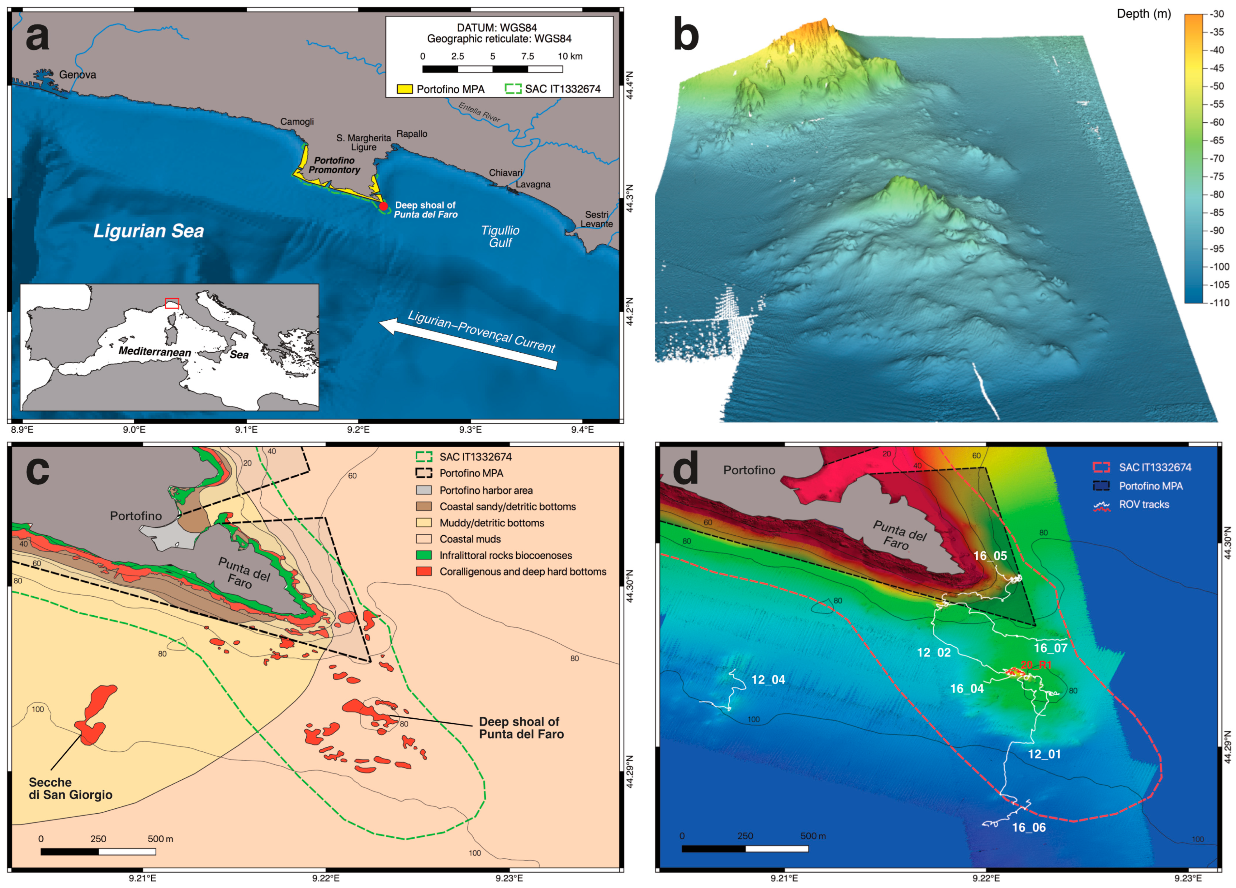
2.1. Study Area

The deep shoal of Punta del Faro lies at the southeasternmost end of the Portofino Promontory. This promontory is located about 25 km E from Genoa, and it is characterized by a rocky coastline interspersed with bays covered by stream deposits (Figure 1a). The eastern and western coasts are made of limestone. In contrast, the southern coast consists of a characteristic Oligocene puddingstone with calcareous clasts [23,24,25]. Here, the submerged cliffs are rich in ravines, roofs, small caves, and rock landslides, greatly enhancing the complexity of the underwater environment. The benthic biocoenoses inhabiting this area have been intensely investigated since the last century [1,23,24,26,27,28,29,30]. Photophilous algae cover the upper bathymetric zone, whereas a complex coralligenous community dominated by Paramuricea clavata (Risso, 1827) and Corallium rubrum (Linnaeus, 1758) extends below depths of 20–25 m. The cliffs rapidly reach 40–50 m in depth, leading to a sub-horizontal detritic bottom.
The Portofino Promontory is influenced by the general cyclonic circulation of the Ligurian-Provençal current [31]. This current moves along the Ligurian coast in a NW direction and is consistent at all depths [32]. The whole area is largely oligotrophic, although phytoplankton blooms can increase chlorophyll levels from late winter to spring and, to a minor extent, in fall [33,34,35]. Several torrential streams flow into the Tigullio Gulf, of which the Entella River is the largest. This freshwater discharge is generally quickly mixed and moved away by the EW-directed predominant current, ensuring good water exchange. However, together with the coastal water of the highly urbanized Tigullio Gulf (rich in particulate matter and inorganic nutrients), these water masses can occasionally modify the physical, chemical, and biological conditions of the marine environment [32,33,35,36,37].

2.2. Legal Framework

The Portofino MPA was established with the Ministerial Decree of 6 June 1998. It is one of the smallest Italian MPAs, covering a total surface of 346 ha and extending along 13 km of coastline (Figure 1a). It is managed by a consortium involving (i) the three municipalities of Camogli, Portofino, and Santa Margherita Ligure, (ii) the Metropolitan City of Genoa, and (iii) the University of Genoa. Portofino MPA hosts many activities, including yachting, scuba diving, and small-scale and recreational fishing, managed under Regulation No. 181 of 04/08/2008, approved by the Italian Ministry for the Environment (1 July 2008). The Portofino MPA is structured by three different subzones, where different restrictions regulate human activities: the no-entry/no-take area (A zone), the general reserve area (B zone), and the area of partial protection (C zone).
Portofino MPA is a Specially Protected Area of Mediterranean Interest (SPAMI) [38], and since 2007, it has been part of the Long-Term Ecological Research (LTER) Italian Network. The MPA is also mostly included in the European Natura 2000 Network as a Special Area of Conservation (SAC) IT1332674 “Fondali Monte di Portofino” (Figure 1a,c), designed by Decree of the Ministry of Environment on the 13 October 2015. The SAC covers 544 ha and, following Directive 92/43/CE, it includes four habitat types: sandbanks, which are slightly covered by sea water at all times (1110), Posidonia beds (1120), submerged or partially submerged sea caves (8330), and reefs (1170). The latter type includes coralligenous reefs, which are considered important at the regional level because of their high diversity and good environmental status: for these reasons, it was given high priority for conservation. Coralligenous reefs (and rocky reefs in the broad sense) extend outside the MPA boundaries, including the rocky elevations of the deep shoal of Punta del Faro. The Consortium manages the SAC, including the deep shoal of Punta del Faro. No management plan, however, is currently in place for this SAC, but some conservation measures (sensu Directive 92/43/EEC) were approved by the Decree of the Ministry of Environment on the 1 July 2008 and by Liguria Region (DGR n. 23, 5 October 2015). The conservation measures established for coralligenous reefs aim to enhance or preserve their environmental status, which is threatened by the effects of fishing gear operating on or near the seabed. These measures include the ban on trawl fishing, artisanal and recreational fishing regulation, ALDFG monitoring and retrieval, education, and sensibilization.
In addition, in 2016, the deep shoal of Punta del Faro was selected for the monitoring of the deep coralligenous environmental status within the Marine Strategy Framework Directive (MSFD) [39].

2.3. Fishing Fleet

The number of artisanal fishermen exploiting the deep shoal of Punta del Faro is scarce. Official data (2023) indicate that 25 artisanal vessels (total length < 10 m) are authorized to operate in the Portofino MPA, where fishing is allowed in zones B and C only for the residents of the three municipalities. Artisanal vessels are mainly equipped with post nets (including gill nets, trammel nets, and combined nets), longlines, and small purse seine [18]. Fishers from nearby harbors (Genova, Lavagna, Chiavari, Sestri Levante) are not known to operate along the outside borders of the MPA.
Similarly, information regarding the anglers exploiting the deep shoal of Punta del Faro is scarce. Recreational fishing within the MPA is highly regulated: it is allowed only for the holders of a specific permit issued by the managing body [19]. In addition, specific restrictions targeting residents and non-residents include the fishing of some species (i.e., the dusky grouper, Epinephelus marginatus (Lowe, 1834)), spatial closures, fishing techniques, logbook compilation, and fishing efforts [19,20,40]. In 2021, the MPA released 211 permits for recreational fishers potentially operating on the deep shoal of Punta del Faro. In addition, the port of Genoa (about 25 km to the west) has more than 5000 recreational boats that can reach the Portofino MPA in less than two hours [41,42]. At the same time, to the east, the marinas of Rapallo, Chiavari, Lavagna, and Sestri Levante provide a further 2000 berths [43]. Recreational fishers use several types of gear and fishing techniques that potentially create entanglement on the seafloor, including vertical lines (bolentino), longlines, deep trolling, and vertical jigging; the latter is forbidden within the MPA because of its high impact on the seafloor [19].

2.4. Biocoenoses Characterization and Health-Status Assessment

To provide a detailed characterization of the benthic biocoenoses found on the deep shoal of Punta del Faro and the surrounding soft bottoms, all the information obtained during three ROV campaigns in 2012, 2016, and 2020 conducted by ISPRA, ARPAL, and the University of Genoa, was collected. Data were recorded on board the R/V Astrea (ISPRA, Rome, Italy) in 2012 and 2016, using a high-resolution Multibeam Echo Sounder (MBES, Kongsberg EM2040) to investigate the topography of the area and a Pollux III ROV to investigate the megabenthic communities through a visual census. The campaign conducted in 2020 was carried out on board the M/B Veliger (University of Genova, Genova, Italy) using a Chinook ROV. The ROVs were equipped with HD video camera, underwater lights, depth sensor, compass, and underwater acoustic positioning system to obtain accurate georeferenced positions (every second). Parallel laser beams provided a scale reference for measurements. A total of eight ROV dives were performed in the SE sector of the Portofino MPA, including (i) the deep coastal cliffs of Punta del Faro, (ii) the deep shoal of Punta del Faro, and (iii) the San Giorgio shoals (Figure 1d). Table 1 provides a list of the ROV dives, with technical information.
The ROV video transects were analyzed following the methodology described by Enrichetti et al. [6]. To provide a detailed picture of the deep shoal of Punta del Faro megabenthic taxa richness, abundance, and occupancy (i.e., the frequency of occurrence), the ROV transects were divided into a string of adjacent 5 m2 sampling units (SU) [6]. The ROV videos were also analyzed to identify the megabenthic biocoenoses characterizing the hard and soft bottoms. The density (no. of specimens or colonies per m−2), average size (±standard error, SE), and population-size structure of the main structuring species were calculated. In addition, seafloor litter was characterized and quantified, and the health status of structuring anthozoans was evaluated considering the percentage of colonies showing signs of necrosis or epibiosis, or that were directly entangled with lost fishing gear. All the data obtained were included in a QGIS project (version 3.22.12) and used to map the distribution of the main biocoenoses and the seafloor litter.
Finally, to assess the environmental status of the hard-bottom biocoenoses of the deep shoal of Punta del Faro and its variation through time, the mesophotic assemblages conservation status (MACS) index [44] was applied to a 100-m−2-long ROV video transect (20_R1; Figure 1d) filmed in 2012 and then replicated in 2016 and 2020.

2.5. Habitat Modeling

Predictive maps presenting the distribution of benthic habitats and organisms are essential to effectively protect and manage marine areas [45,46]. In the present study, to provide a full coverage map of the megabenthic communities of the eastern Portofino Promontory, the communities defined with multivariate clustering techniques by Enrichetti et al. [6] were analyzed by means of a classification model. A classification model is a type of machine-learning model used to categorize or classify data into predefined classes or categories based on input features. The goal of a classification model is to learn patterns and relationships within data that can be used to predict the class labels of new, unseen instances. The input features considered in this study were a set of environmental variables extracted from geomorphological maps produced with a high-resolution Multibeam Echo Sounder (MBES, Kongsberg EM2040, ISPRA). Environmental variables, including depth, slope, topographic-position index (TPI), terrain-ruggedness index (TRI), aspect, and roughness, were used as explanatory variables for the prediction of the habitat presence. Thus, using the values of these independent variables, the model was designed to predict dependent variables, such as the presence and coverage of megabenthic communities. In particular, the distribution of the megabenthic communities according to environmental variables was predicted using random forest (RF) classification [47], following the methodology described by Vassallo et al. [48].
The algorithm utilized in this study is based on classification-tree methodology, which enables the modeling of a response variable using multiple explanatory variables by dividing the dataset into subgroups. These subgroups are represented as a binary tree, a hierarchical structure with nodes and edges that depicts information flow between adjacent nodes. The subgroups are formed through recursive partitions based on decision rules, leading to the progressive division of each part into smaller data portions. Two key techniques are employed: (1) random selection of explanatory variables to grow each tree, and (2) the building of each tree from a different random subset of data created through bootstrapping [49]. The process identifies the optimal “splitting” that best fits the real data and selects it as a predictor. The training subset of data used for this purpose is called the “in-bag” data, while the remaining data is termed the “out-of-bag” data. The “out-of-bag” data are not utilized in tree construction, but provide estimates of generalization error, which improve as the number of trees in the forest increases [47]. To identify the most influential explanatory variables, the ranking of their importance is determined based on changes in mean square error when a variable is excluded from the model. The analysis was implemented using the randomForest R package [50].

2.6. Fishing-Pressure Quantification

To assess fishing pressure on the deep shoal of Punta del Faro, 13 artisanal and 64 recreational fishers operating within the Portofino MPA were interviewed from February 2021 to April 2023. Questions aimed to collect information on (i) the number of fishers exploiting the site, (ii) the number of fishing days per year on which the site is exploited, (iii) the gear employed and the target species, (iv) the frequency of gear entanglement on the seafloor, and (v) the frequency of gear loss.

3. Results

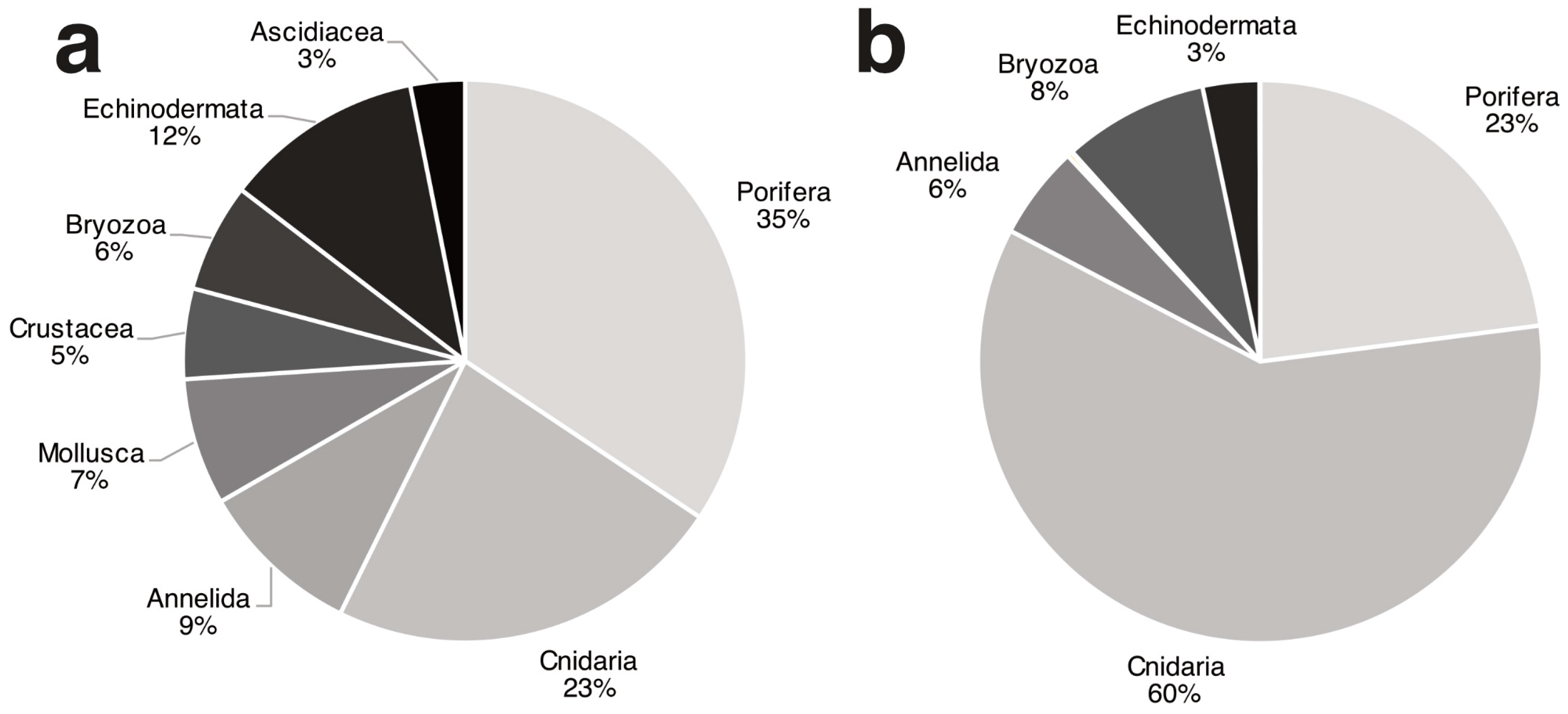
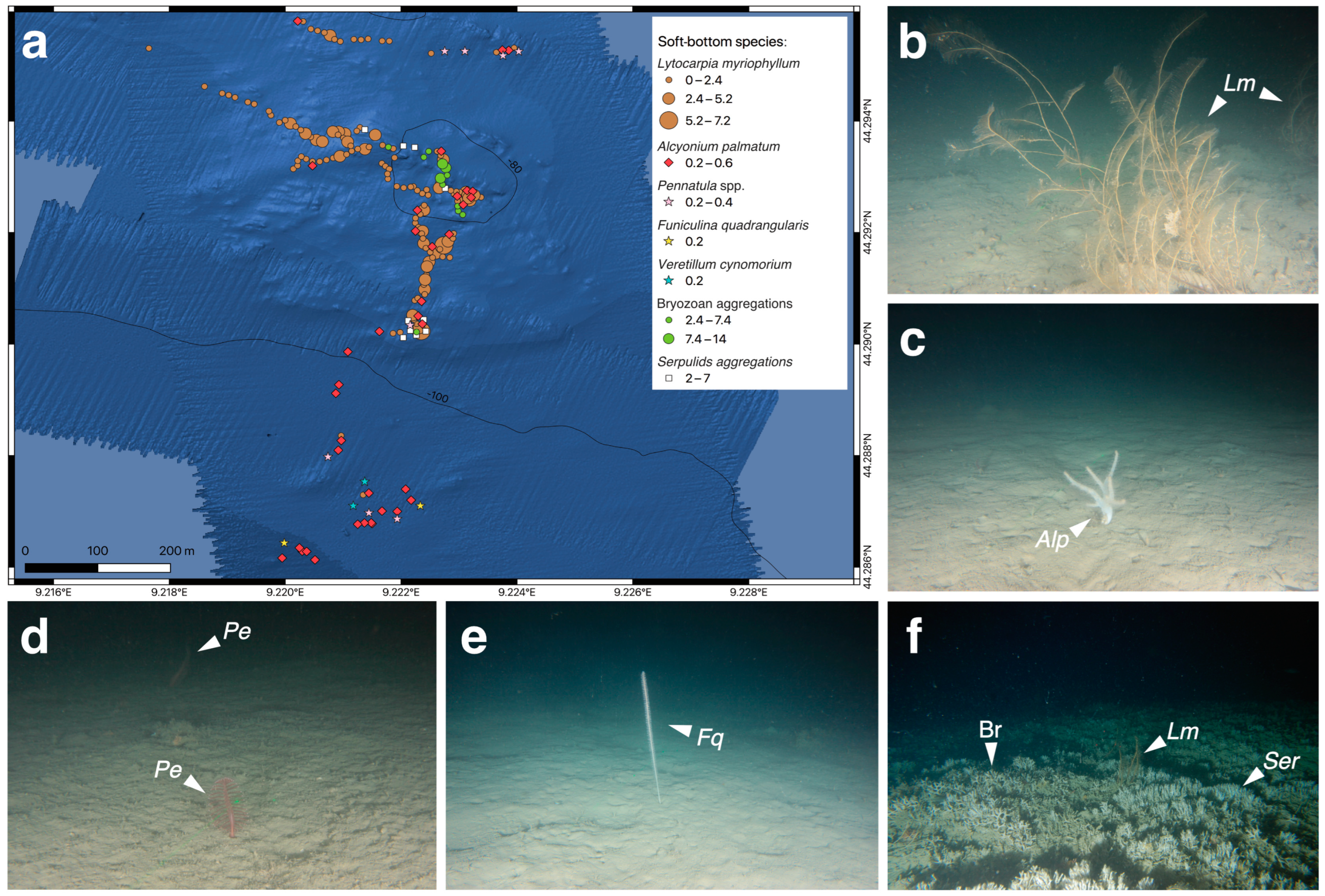
3.1. Biocoenotic Characterization

Ninety-six megabenthic operative taxonomic units (OTUs) were reported in the deep shoal of Punta del Faro and the surrounding soft bottoms, corresponding to 11,480 organisms (Table S1). Sponges (33 OTUs), cnidarians (22 OTUs), and echinoderms (11 OTUs) were the most important phyla contributing to the total diversity (Figure 2a). The most important groups in terms of abundance were those of the cnidarians (accounting for 6858 specimens), sponges (2635 specimens), and bryozoans (954 specimens) (Figure 2b). The gorgonian Eunicella cavolini was the most abundant species (3329 colonies), followed by the yellow sponge, Axinella spp. (1897 specimens), its epibiont, Parazoanthus axinellae (Schmidt, 1862) (1233 colonies), and the large hydrozoan, Lytocarpia myriophyllum (1231 colonies). The highest level of occupancy was that of the cnidarians (74%), followed by those of the bryozoans (41%), annelids (40%), and sponges (33%). The highest occupancy value was presented by L. myriophyllum (37%), followed by Axinella spp. (29%) and the Filograna/Salmacina species complex (25%).
Several structuring species were observed in the ROV footage (Table S1), including cnidarians, sponges, and bryozoans. On the rocky bottoms (Figure 3), the yellow gorgonian E. cavolini was the most significant structuring species, forming dense forests, with densities of up to 28.8 colonies m−2. Other gorgonians increased the complexity of these forests, including Paramuricea clavata (6.8 colonies m−2), Eunicella verrucosa (Pallas, 1766) (1.6 colonies m−2), and Leptogorgia sarmentosa (Esper, 1791) (0.2 colonies m−2). Sparse colonies of E. verrucosa and L. sarmentosa were also reported in the surrounding scattered and partially sediment-covered hard bottoms. The black coral Antipathella subpinnata formed distinct facies in the NW sector of the shoal, where it reached a density of 2.6 colonies per m−2. The structuring sponges included Sarcotragus foetidus Schmidt, 1862 (2.2 specimens m−2), Spongia (Spongia) lamella (Schulze, 1879) (0.8 specimens m−2), and Axinella polypoides Schmidt, 1862 (0.2 specimens m−2). In addition, Aplysina cavernicola (Vacelet, 1959) was particularly abundant on the shoal, forming dense aggregations of up to 16.8 specimens per m−2.
The detritic bottoms surrounding the shoal (Figure 4) were dominated by the large hydrozoan, L. myriophyllum, showing maximum density values of 7.2 colonies per m−2 at depths between 80 and 100 m. The soft coral, Alcyonium palmatum Pallas, 1766, was another common species inhabiting these bottoms, reaching maximum densities of 0.6 colonies per m−2. Pennatulaceans accounted for four species, Pennatula rubra (Ellis, 1764), Pennatula phosphorea Linnaeus, 1758, Funiculina quadrangularis (Pallas, 1766), and Veretillum cynomorium (Pallas, 1766), all of which were characterized by low abundance. The F. quadrangularis and V. cynomorium were only reported at depths below 100 m. The westernmost and southernmost sectors of the shoal were characterized by high-density aggregations created by bryozoans and serpulid tubes of the species complex Filograna/Salmacina.
The fish fauna observed by ROV was rich, accounting for 15 taxa. It included commercial species, such as the European conger, Conger conger (Linnaeus, 1758), the black-bellied rosefish, Helicolenus dactylopterus (Delaroche, 1809), the red mullet, Mullus surmuletus Linnaeus, 1758, the forkbeard, Phycis phycis (Linnaeus, 1766), the small red scorpionfish, Scorpaena notata Rafinesque, 1810, and the black scorpionfish, Scorpaena porcus Linnaeus, 1758. Other species included the swallow tail, Anthias anthias (Linnaeus, 1758), the shore rockling, Gaidropsarus mediterraneus (Linnaeus, 1758), Labrus mixtus Linnaeus, 1758, Lappanella fasciata (Cocco, 1833), Serranus cabrilla (Linnaeus, 1758), and the cuckoo wrasse, Chelidonichthys lastoviza (Bonnaterre, 1788). Catshark eggs were observed on the ramifications of the gorgonian E. verrucosa.

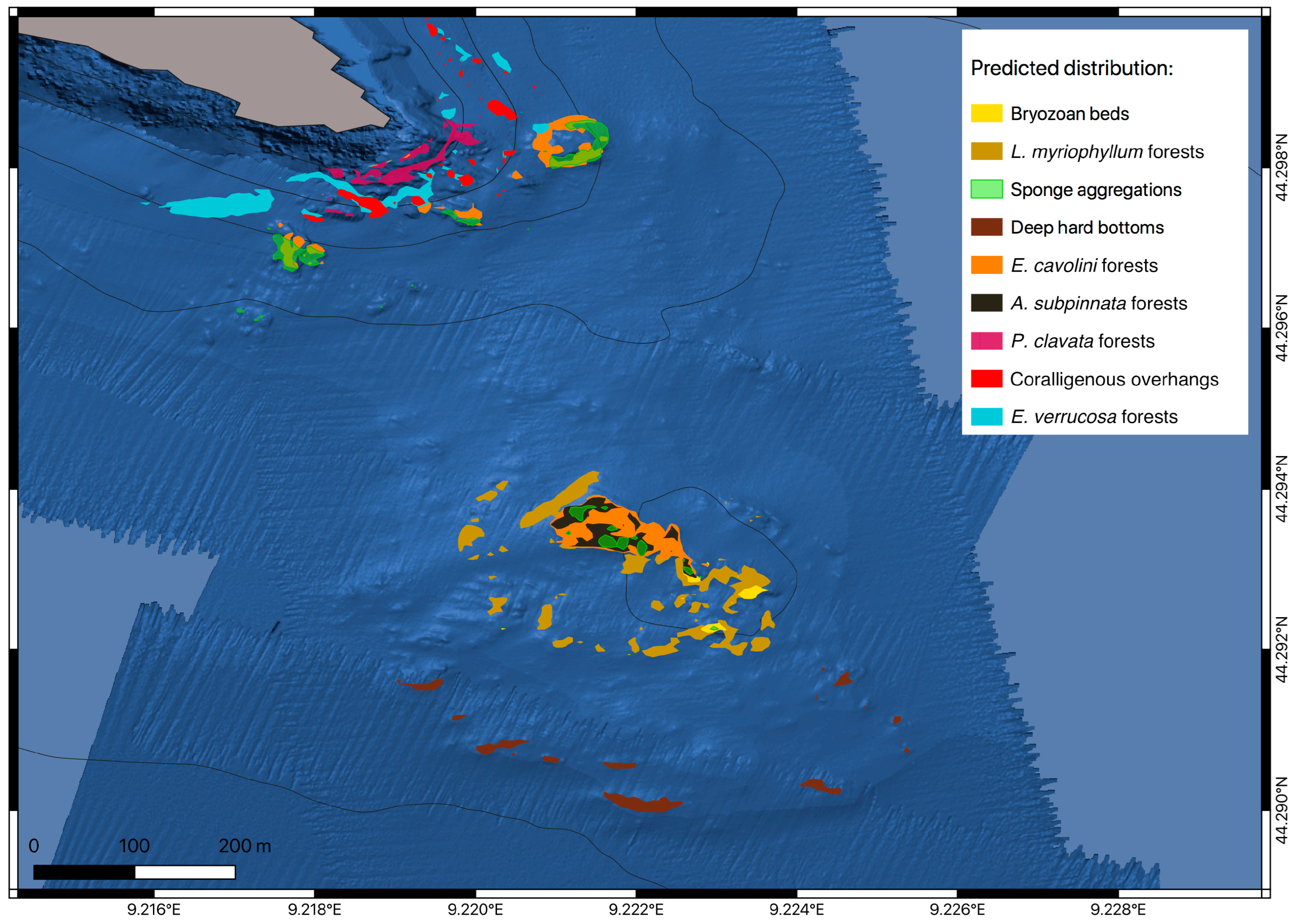
3.2. Predictive Habitat Mapping

According to the classification model, the most important factors determining the distribution of the species were slopes, roughness, and depth (Table 2). This model predicted with the highest accuracy the communities of the A. subpinnata and E. cavolini forests (Table 3). By contrast, higher rates of incorrect predictions were reported for the community of P. clavata forests.
The random forest algorithm predicted the spatial distribution of the megabenthic communities inhabiting the eastern sector of the Portofino Promontory (Figure 5). The model indicated that the megabenthic communities inhabiting the deep shoal of Punta del Faro differ substantially from those encountered along the Portofino cliffs. Only two out of nine communities are shared between the two areas, namely the sponge aggregations and E. cavolini forests (Figure 5). Forests of A. subpinnata, large hydrozoans, bryozoan aggregations, and deep hard bottoms with scarce biological cover were only reported in the deep shoal of Punta del Faro. In contrast, aggregations of E. verrucosa, P. clavata, and coralligenous overhangs characterized the coastal areas.
The model confirmed the presence of an E. cavolini community dominating the hard bottoms of the shoal, with some patchy areas dominated by sponges. The model suggests that the area suitable for A. subpinnata is not restricted only to the NW sector of the shoal, and that it could potentially be broader. The outcropping and sub-outcropping rocks located in the southern sector of the shoal are characterized by scarce coverage, mainly by encrusting sponges, serpulids, and echinoderms. According to the model, the L. myriophyllum community is located on detrital bottoms among minor rocky elevations in the central part of the shoal, between 70 m and 90 m in depth. The occurrence of the bryozoan beds recalls that observed in Figure 4, confirming that this community occurs near small rocks in the SE sector.

3.3. Structuring Species’ Morphometry and Size Distribution

Figure 6a reports the mean heights of the main structuring species. The highest values were presented by L. myriophyllum and A. subpinnata, accounting for 30.4 ± 0.8 and 28.8 ± 2.4 cm, respectively. The largest colonies were presented by P. clavata (average height 23 ± 1.7 cm), reaching up to 75 cm in height. Furthermore, Eunicella cavolini and E. verrucosa showed low average values, but presented high maximum heights, reaching 70 cm and 50 cm, respectively. The sponges presented intermediate average heights and the smallest maximum heights, corresponding to 35 cm for S. foetidus and 40 cm for Spongia lamella.
The size-class distributions of the main structuring cnidarians, Antipathella subpinnata and E. cavolini, showed a unimodal distribution, with a peak in the second size class (heights 10–20 cm) (Figure 6b,c). Unimodal distributions were also displayed by E. verrucosa and L. myriophyllum (Figure 6d,e), with the former presenting a peak in the first size class (0–10 cm) and L. myriophyllum peaking in the fourth size class (30–40 cm). P. clavata was the only species showing a bimodal distribution (Figure 6f), with peaks in the first and fourth size classes.

3.4. Environmental Status of the Benthic Biocoenoses

The seafloor-litter analysis indicated a mean density of 0.65 ± 0.05 items per m−2. The litter composition presented a strong predominance of ALDFGs, accounting for 74%. In contrast, general urban litter represented the remaining 26% (Figure 7a). The distribution of the two litter categories is shown in Figure 8a,b. The ALDFGs were mainly distributed on the hard bottoms, reaching an average density of 0.71 ± 0.10 items per m−2. Fishing lines, longlines, and ropes were the most common types of ALDFG observed on the seabed (Figure 8c). Lost fishing nets were mainly represented by trammel nets (Figure 8d,e) and trammel-net fragments, whereas only one gillnet and one trawl net were reported. The other main ALDFG were several types of mooring, including bricks (Figure 8f) and sacks of stones. Only a few objects were ascribable to the category of urban litter, and these mainly included plastic items (e.g., bags, sheets, and bottles; Figure 8g,h). Other items included tires (Figure 8i), glass bottles (Figure 8g), anchors, and unidentified metallic objects (Figure 8j). The urban-litter distribution was more uniform than that of the fishing litter.
Overall, 20% of the structuring cnidarians observed in the deep shoal of Punta del Faro (n = 4986 colonies) showed signs of impact, including (i) the overgrowth of epibiotic organisms, (ii) the presence of necrotic portions, and (iii) direct entanglements with fishing gear (Figure 7b). Entanglement was the most common type of impact, involving, on average, 16% of the colonies. Epibiosis affected 11% of the structuring species, and necrosis affected 6%. Antipathella subpinnata showed the highest percentage of affected colonies (35%), followed by P. clavata (28%), E. verrucosa (22%), and E. cavolini (21%).
Finally, the application of the MACS index showed a poor situation overall for the deep shoal of Punta del Faro, with no discernible temporal variations from 2012 to 2020 (Table 4). Minimal variations were recorded for three metrics, namely structuring-species height, epibiosis, and litter density.

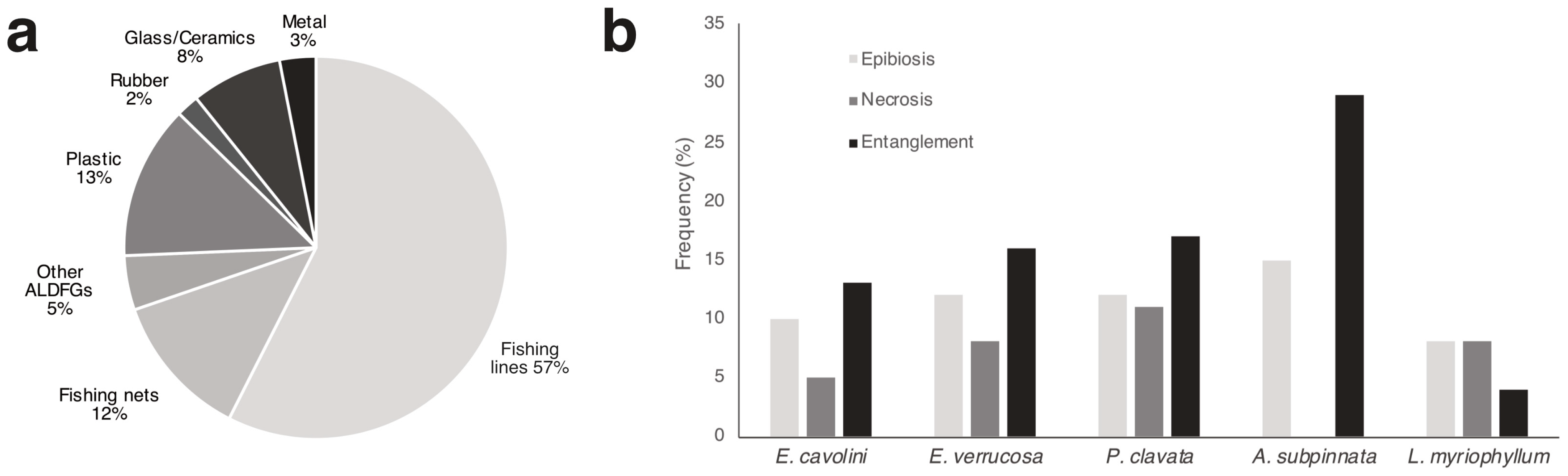
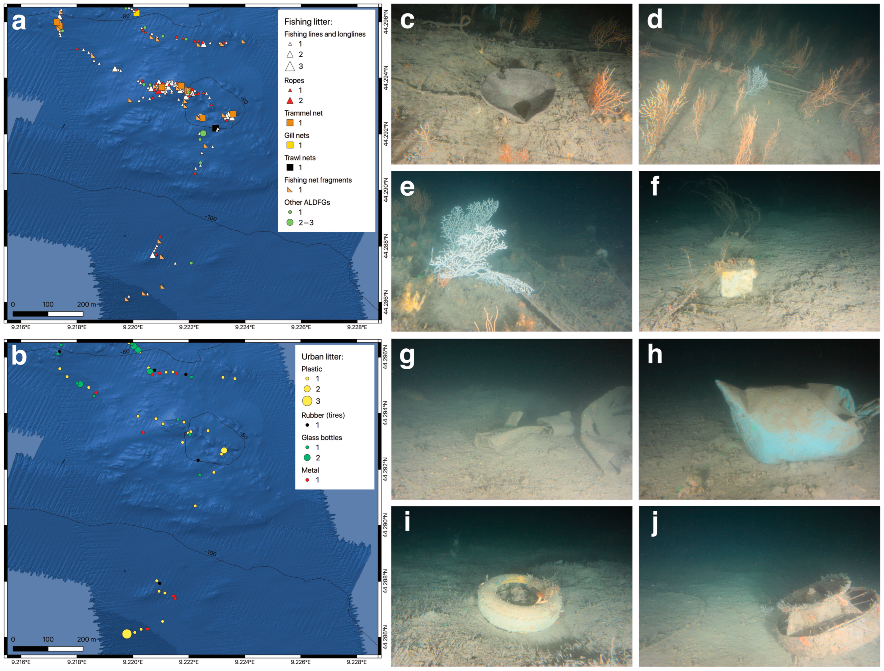
3.5. Fishing Pressure

The interviews carried out during the present study indicated that the number of artisanal fishers exploiting the MPA and its nearby areas has gradually decreased in the last decades, and that it currently does not exceed ten to twelve boats. The fishers reported that the fishing effort on the deep shoal of Punta del Faro was high until 15–20 years ago, when some artisanal vessels operated up to 20–30 times per year. Only one artisanal fisherman stated that he currently fishes on the deep shoal, and that he does so, at most, 2–3 times yearly. Another artisanal fisher stated that he exploits the shoal only occasionally, up to once per year. Both fishers work alone on their fishing boats, which are 6.7–7.3 m in total length, weigh 1–2 gross tons, and engine power 20.5–35 kW. The types of fishing gear employed on the deep shoal of Punta del Faro include trammel nets and, occasionally, bottom longlines. The main target species are the spiny lobster, Palinurus elephas (Fabricius, 1787), scorpionfishes (e.g., Scorpaena scrofa Linnaeus, 1758), anglerfishes (e.g., Lophius piscatorius Linnaeus, 1758), and the John Dory Zeus faber Linnaeus, 1758. The fishing activities are mainly undertaken during spring and summer when the weather conditions are more stable.
The interviewed fishers consider this fishing ground risky because of the rough topography of the shoal and the strong bottom currents. In addition, the large number of lost fishing gear further increases the probability of entanglement on the seafloor. Additionally, the fishermen complained about the considerable decrease in the abundance of target species along the Portofino Promontory in the last decades. In addition, the heavy maritime traffic during summertime (including passenger-transport ships, recreational boats, and recreational fishing boats) makes it challenging to perform setting and hauling operations. For these reasons, most artisanal fishers consider risking their nets in this fishing ground worthless. The interviewed fishers declared that entanglements on the seafloor of the shoal are quite common when using both trammel nets and longlines. In addition, the strong bottom current stretching the trammel nets on the seafloor results in the collection of large quantities of cobbles and benthic organisms. According to the fishers, the discarded benthic species included sponges, gorgonians, sea urchins, holothurians, sea stars, and the ophiuroids, Astrospartus mediterraneus (Risso, 1826); the latter considerably increased in the last ten years (up to 20 specimens were collected per trammel net haul). One case of gear loss (a trammel net) on the deep shoal of Punta del Faro emerged from the interviews; the fisher asserted that this trammel net was subsequently retrieved using specific ropes with hooks.
All the recreational fishers interviewed in this study declared that they do not fish on the deep shoal of Punta del Faro. However, recreational fishermen’s boats, using vertical lines, deep trolling, and recreational longlines, are commonly observed by other stakeholders operating in the area.

4. Discussion

4.1. The Deep Shoal of Punta del Faro in the Context of the Portofino MPA

The deep shoal of Punta del Faro presents unique features within the Portofino Promontory area. It is a typical temperate mesophotic rocky reef [51,52] dominated by marine animal forests (MAFs) [53]. According to the classification of the Mediterranean MAFs located within 40 m to 200 m [54], the biocoenoses in this shoal can be considered “continental shelf assemblages” because, despite the proximity to the coastline (located about 500 m from the nearest point), a clear connection with the littoral biocoenoses is lacking. Indeed, the megabenthic communities thriving on the studied shoal do not represent a direct bathymetric continuum of the coastal communities; rather, they are separate entities e.g., [54,55,56]. This is clearly highlighted by the predictive habitat model presented here: four distinct megabenthic communities characterizing the deep shoal and the surrounding soft bottoms (i.e., bryozoan beds, L. myriophyllum forests, deep hard bottoms, and A. subpinnata forests) were not found along the coastal cliffs of the Portofino Promontory (Figure 5). It is also true that the distributions of some species, including the red coral, Corallium rubrum (Linnaeus, 1758), and the gold coral, Savalia savaglia (Bertoloni, 1819), and a few megabenthic communities (i.e., P. clavata forests, coralligenous overhangs, and E. verrucosa forests), which are typical of the Portofino coastal area, do not extend onto the deep shoal of Punta del Faro. According to the predictive habitat model, only two megabenthic communities are shared between the coastal and deep areas, corresponding to E. cavolini forests and sponge aggregations. However, these communities show distinct characteristics in the two different habitats, with differences in specimen density, size, and species composition (for the sponge aggregations). For this reason, we can consider the deep shoal of Punta del Faro as characterized by offshore circalittoral rock (MD1.5) [57] or Roche du Large (RL) biocoenosis sensu Pérès and Picard [58].
The complex topographic features of the shoal consist of multiple inclinations and exposure gradients, allowing the co-occurrence of several types of animal forests (Figure 4 and Figure 5) and greatly enhancing the biodiversity levels. Indeed, the shoal hosts 96 out of the 115 megabenthic species (83%) identified in the Portofino mesophotic area [6]. Hard bottoms at similar depths are rare in the Portofino area because the coastal cliffs generally end at about 45 m. Unlike the studied shoal, the few other known mesophotic outcropping rocks, namely the San Giorgio shoals (90 m depth; Figure 1c,d) and the Villa Augusta shoal (100 m to 120 m in depth, located about 1 km SE of the first), are characterized by scarce biogenic cover, high sedimentation levels, and a generally low abundance of structuring species [6]. From the oceanographic point of view, the deep shoal of Punta del Faro lies in a peculiar position. It faces the Tigullio Gulf and is highly influenced by its coastal water masses, which are rich in inorganic nutrients and particulate matter [33,35,36]. These waters are moved westward by the Ligurian–Provençal current [31], thus transiting above the shoal and its megabenthic communities and providing an additional source of food for benthic filter-feeders [8,59].
The major structuring species of the shoal, the gorgonian Eunicella cavolini, is common along the whole southern border of the Portofino Promontory [12,21,60,61]. However, the facies on the shoal differ entirely from the coastal facies, since it is characterized by higher densities and larger colonies. The maximum density value reported in the present study (29 colonies per m−2) is more than twice as high as the maximum value reported for the coastal populations (13 colonies per m−2) [21]. The average heights of the colonies and the size-class distributions reported by the two studies are similar. However, the maximum height is greater on the deep shoal of Punta del Faro, with some colonies up to 70 cm in height (the maximum height reported for the coastal population is 24 cm) [21]. The large size and the high density reached by E. cavolini on the shoal suggest the pivotal role played by this forest in increasing local benthic complexity and biodiversity. E. cavolini forests are among the richest Ligurian mesophotic megabenthic communities in terms of associated species diversity [6], with the soft coral Alcyonium coralloides (Pallas, 1766), the yellow sponges Axinella spp., holothurians, and the large ophiuroid A. mediterraneus listed among the most common associated species.
Bo et al. [62] reported ten colonies of A. subpinnata at depths of 60 m on the Isuela shoal (located at the westernmost end of the Portofino cliff), based on divers’ sightings. This small population, characterized by colonies 40–70 cm high and bearing catsharks’ eggs, was not found during the extensive ROV explorations conducted in 2012, 2016, and 2020 by ARPAL, ISPRA, and the University of Genoa, respectively. For this reason, the black coral forest of the deep shoal of Punta del Faro probably represents the sole current population of the Portofino Promontory. Two additional small colonies of A. subpinnata (15 and 20 cm high, respectively) were observed in 2016 on the Villa Augusta shoal (about 2 km W of the deep shoal of Punta del Faro) at a depth of 95 m. Considering the water-circulation pattern, these colonies may have originated in the deep shoal of Punta del Faro population. In line with this hypothesis, the size-frequency distribution of A. subpinnata presented high frequencies in the largest size classes (higher than 50 cm; Figure 6e), indicating that reproductive colonies may be present and that they can sustain other populations [63]. Asexual reproductive strategies, including colony fragmentation and polyp bail-out [7,64], may provide additional sources of propagules and contribute to the strong genetic connectivity characterizing the mesophotic populations of this species [10]. A similar observation can be made for the three recorded gorgonian species (Figure 6b–d): the large colonies thriving on the shoal may act as sources of larvae for the shallower coastal populations along the Portofino Promontory cliffs. However, this hypothesis was proven false for some gorgonian species in temperate seas [65].
The occurrence of L. myriophyllum forests in the easternmost sector of the Portofino MPA is well documented [1,4,5,6,23,66,67]. The population of L. myriophyllum investigated by Di Camillo et al. and Cerrano et al. [4,5] is located at a depth of 70 m, about 50 m from the base of the Portofino Promontory in the NE sector of Punta del Faro. Here, L. myriophyllum extends for over 300 m2, with a dense core area of about 50 m2, where colonies reach densities of up to 1.6 colonies per m−2. This area is characterized by high sedimentation and a seabed rich in mud and biogenic detritus, similar to the site investigated in the present study. The population inhabiting the deep soft bottoms near the deep shoal of Punta del Faro (located approximately 700 m south) reaches higher densities (seven colonies per m−2) and occupies a wider area (approximately one hectare, based on the predictive model). The size-class distribution of this species indicates a mature population, with the fourth size-class (30–40 cm) as the most represented and with some large specimens up to 60 cm in height. Lytocarpia myriophyllum forests play a relevant ecological role by significantly increasing local biodiversity [5]. The large colonies create complex habitats on soft bottoms, providing refuge for other organisms. Several sessile and vagile organisms live in association with the ramification of this hydrozoan, including foraminiferans, other hydrozoans, anemones, solenogasters, bivalves, gastropods, crustaceans, and bryozoans [5]. In addition, Cerrano et al. [4] demonstrated that benthic meiofaunal and nematode taxa richness is higher within L. myriophyllum forests than in surrounding bare sediments, proving that this species strongly influences benthic biodiversity. Furthermore, in the present study, several fishes were observed hiding among L. myriophyllum colonies, including mullets, gurnards, and the comber Serranus cabrilla, thus confirming the attractive role of this habitat-forming species for the ichthyofauna.
A final remark concerns the distribution maps and the predictive habitat model presented in this study, which are informative and easy-to-interpret tools that help managers to set conservation priorities and specific actions. The random forest algorithm was chosen to predict the spatial distribution of the megabenthic communities inhabiting the eastern sector of the Portofino Promontory, including the deep shoal of Punta del Faro. This algorithm has gained in popularity in the past years as one of the most powerful tools with which to map shallow and deep-sea species and habitats [68]. In the present study, the model always explained with high accuracy (>70%) the outcomes of the nine investigated benthic habitats, generating a high degree of confidence. However, this high accuracy most possibly related to the restricted extension of the studied area and to the limited number of explanatory variables included in the model. Indeed, the predictive mapping was entirely based on geomorphological layers derived from the multibeam bathymetry raster, precisely the depth, slope, TPI, TRI, aspect, and roughness. The incorporation of additional layers would largely improve the predictive ability of the model. In particular, fine-scale oceanographic data, including bottom currents, wave action, nutrient concentration, and phytoplankton abundance, would contribute to a better delineation of the biological parameters. Unfortunately, such information is not yet available for the study area, and the results of the predictive habitat model presented here should be considered preliminary.

4.2. Peculiar Attributes of the Shoal at a Regional Scale

The deep shoal of Punta del Faro also shows exceptional features when it is considered on a broader spatial scale. The biodiversity levels (96 taxa) are high compared to the total number of species identified for the whole Ligurian deep continental shelf and shelf break from the ROV video footages (220 taxa) [6]. The shoal hosts almost half (44%) of the total Ligurian mesophotic megabenthic diversity. The biodiversity values, taxa composition, and abundances (Figure 2a,b) are comparable with those of other Mediterranean sites explored with ROVs at similar depths, including the Maledetti shoal (W Ligurian Sea) [69], the Cap de Creus (Gulf of Lions) [68], the Menorca Channel (Balearic Sea) [70], the Gulf of St. Eufemia (SE Tyrrhenian Sea) [55], and the Seco de Los Olivos Seamount (Alboran Sea) [71]. Many species reported on the deep shoal of Punta del Faro are canopy-forming organisms, including sponges, hydrozoans, anthozoans, polychaetes, and bryozoans. Most of these species are suspension feeders, a functional group that plays a fundamental role in transferring energy and organic matter between pelagic and benthic ecosystems [72,73,74]. In addition, the shoal and its surrounding soft bottoms host 19 megabenthic species of high biological interest and protected by international conventions, including sponges, anthozoans, crustaceans, and echinoderms (Table S1; SAC IT1332674). In addition to species, the deep shoal of Punta del Faro hosts several benthic habitats listed in international classification schemes, including Annex I of the EU Habitat Directive (habitat 1170 “Reefs”), the Council of Europe Bern Convention 1996 (1122—sublittoral soft seabeds and 1125—sublittoral organogenic concretions), and the most recent versions of the EUNIS and the SPA/RAC UNEP/MAP habitat classifications [57].
Two megabenthic communities are exclusive of the deep shoal of Punta del Faro when considering the whole eastern Ligurian Sea. For instance, dense mesophotic gorgonian forests of E. cavolini are absent from the entire eastern Ligurian Riviera. Apart from the shallow-water populations of the Portofino cliffs [12,21,60,61], the population of the deep shoal of Punta del Faro is the sole mesophotic population in the region [6]. Indeed, the nearest E. cavolini mesophotic population lies about 60 km W, on the Mantice shoal (in the western sector of the Ligurian Sea) [6,13], whereas to the SE, the nearest mesophotic populations are located on the off-shore Santa Lucia seamount [13], the western coast of Corse Island [75], and the Tuscan Archipelago [76,77], located at distances of about 80 km, 150 km, and 200 km, respectively. Considering the general circulation pattern of the region [31], the E. cavolini forest described in this study may represent a fundamental link between the NW Mediterranean Sea populations. This forest presents attributes (average density and average and maximum height) comparable to those at other Mediterranean sites [6,68,78,79,80]. This species suffers from the mechanical impact of demersal fishing practices and, as a consequence of global warming, its shallow populations have been subjected to severe mass-mortality events in the Mediterranean Sea in the last 30 years [21,60,81,82,83,84]; for these reasons, E. cavolini is listed as near-threatened by the Mediterranean IUCN Red List for anthozoans [85].
In addition to gorgonians, black corals are other major structuring species in the Mediterranean Sea [54,86], and the presence of a stable population of A. subpinnata on the deep shoal of Punta del Faro must be considered relevant, mainly because it is the only population confirmed in the eastern Ligurian Sea [6]. As in the case of E. cavolini, the population thriving on the studied shoal may represent a link between the Corse, Tyrrhenian, and western Ligurian populations. Indeed, the nearest populations of A. subpinnata are located on the Mantice shoal (in the western sector of the Ligurian Sea) to the W [6,13,87], on the off-shore Santa Lucia seamount [13], the western coast of Corse Island [75], and the Tuscan Archipelago [62,76] to the SE. As mentioned above, a considerable number of multidisciplinary studies have focused on the biology of the A. subpinnata forest of the deep shoal of Punta del Faro, probably making this population the most studied in the Mediterranean Sea [1,6,7,8,9,10]. At the international level, several regulations target the conservation of A. subpinnata. The Barcelona Convention lists this species in Annex II, among the endangered or threatened species. The species is also mentioned in Annex II of the CITES Convention. A. subpinnata is also listed as near-threatened on the Mediterranean IUCN Red List for anthozoans [85]. Together with other black corals, it is considered indicative of Vulnerable Marine Ecosystems (VMEs) by FAO due to its low growth rate, late sexual maturity, and low resilience to mechanical disturbances.
The deep shoal of Punta del Faro is also peculiar when considering other megabenthic communities, including those dominated by large hydrozoans, keratose sponges, bryozoans, and serpulids [6]. Keratose-sponge grounds are common in the western Ligurian Sea. In contrast, in the eastern sector, high densities of Sarcotragus foetidus (up to three specimens per m−2) were only reported on the deep shoal of Punta del Faro [88]. This species is common along the Portofino coastal cliffs, but always presents low densities. Curiously, the other large keratose sponge, S. lamella, once considered common along the coastal cliffs, is now rare and only reported on the deep shoal of Punta del Faro. Lytocarpia myriophyllum is widely distributed in the eastern Ligurian Sea, and has been commonly reported as a species that is discarded by trawlers [89]. However, the population described in the present study represents the largest and densest in the region [5,6], thus deserving maximum conservation efforts. The community dominated by serpulids and bryozoans has been less investigated, and the taxonomical identity of the major structuring species still needs to be determined. The dominant bryozoan was tentatively identified as Pentapora fascialis (Pallas, 1766) in a previous study [6]: this species is widely distributed in the Ligurian Sea, where it is known to form aggregations in shallow waters [90,91] and dominates a distinct megabenthic community at mesophotic depths [6]. The occurrence of these fragile organisms characterized by delicate carbonate structures on horizontal soft bottoms can be considered an indicator of environmental stability, especially concerning coastal trawling activities [92,93].

4.3. Fishing Pressure on and Environmental Status of the Shoal

The lack of historical monitoring makes it difficult to reconstruct the exploitation trend of the deep shoal of Punta del Faro, with the first evidence of the impact of fishing activities on its megabenthic communities reported by Cattaneo-Vietti et al. [1]. In the present study, the fishers’ interviews established that (i) the artisanal fishing effort is now low compared to 15–20 years ago, (ii) the yields are poor, and (iii) the risk of the entanglement of the gear is high. Trammel nets are among the most common nets employed by artisanal fishermen in the Mediterranean Sea [94,95] and are known as potentially highly disruptive, especially in areas characterized by complex topography and strong currents [69,96,97,98]. The trammel-net métier employed at this site can be considered an “aragostara” (a trammel net for spiny lobsters), which features specific characteristics that make it particularly problematic in terms of incidents on outcropping rocks, which host vulnerable habitats. This net is lowered directly onto outcropping rocks, attracting target species thanks to the accumulation of the carcasses of previously trapped fishes [99]. In line with the soaking time, the target catches and the probability of entanglement on the seafloor increase, resulting in the abundant discarding and lower survival potential of the caught species [69,99,100,101,102,103]. The benthic discard-collection rates were not estimated in the present study. However, the fishers’ interviews and the information in the literature suggest high collection rates of both sessile and vagile taxa, including structuring species, such as sponges, cnidarians, and bryozoans [69,99,104]. The catchability of these species is influenced by several factors, including the exposure of the colonies and the shape, size, and strength of the skeleton [13,105,106,107]. Particularly interesting is the high collection rate of the basket star, Astrospartus mediterraneus, reported by one fisher. This observation confirms the population growth reported for this species in the last ten years in some NW Mediterranean areas, including the deep shoal of Punta del Faro [59,108]. In addition, the interviewed fishers report extensive collections of substrate attributable to the scouring of nets over the seafloor. This causes significant modifications of the seafloor integrity, one of the most relevant descriptors of the EU Marine Strategy Framework [69].
Based on the information retrieved during the fishers’ interviews, the frequency of seafloor entanglement with trammel nets and longlines at this site is high. This high frequency is explained by the tendency of the fishers to set their fishing gear directly above the boulders and outcropping rocks of the shoal, where the complex topography, the presence of dense aggregations of branched organisms, and the high abundance of previously lost fishing gear increase the number of entangling events during hauling [69,109,110]. The high density of ALDFGs observed on the shoal and their heavy encrustation by organisms suggest long spans of time on the seafloor [111]. The density values (on average, 0.65 items per m−2) are comparable to those reported at other mesophotic Mediterranean sites known to be affected by fishing activities [11,13,16,69,109,112,113,114,115,116]. The composition of the seafloor litter (Figure 7a) suggests artisanal and recreational fishing as the major causes of the anthropogenic impact on the shoal. The mechanical stress caused by both operating and lost demersal fishing gear leads to major changes in the size structures of the anthozoan populations, leading to a shift towards the small–medium classes (Figure 6b–f), and increases the frequency of epibionted and necrotic colonies (Figure 7b), as observed at other sites [13,107]. Given the gasoline expenses, the risk of losing nets, the time spent cleaning gear from discard and litter, and the low average revenues from catches, this activity proves to be unprofitable, explaining the fishing-effort reduction in the last decades. A similar situation was reported for the trammel-net fishery on the Maledetti shoal, located in the western Ligurian Sea [69].
Recreational anglers certainly contribute to the general deterioration of the area, causing the production of new fishing litter and increasing anthozoan entanglements, breakages, and tissue abrasions. Unfortunately, the full characterization of the impact of recreational fishing is not yet possible. During the present study, 64 recreational fishers were interviewed, none of whom claimed to fish on the deep shoal of Punta del Faro. However, artisanal fishermen and other stakeholders report recreational fishing boats often operating over the shoal, especially during summer, using different types of demersal fishing gear, including vertical lines, deep trolling, and recreational longlines. In addition, artisanal fishermen lament the entanglement of several recreational fishing devices (e.g., hooks, lines, and weights) in their nets. The recreational fishers with specific permits issued by the Portofino MPA’s managing body (corresponding to those interviewed in the present study) may prefer to fish within the MPA borders, whereas the recreational fishers exploiting the deep shoal of Punta del Faro arrive from nearby harbors, (e.g., Genova, Lavagna, Chiavari, and Sestri Levante) [19].
In the present study, the MACS index was tentatively used to assess the environmental status of the deep shoal of Punta del Faro over nearly a decade (2012–2020). The results should be considered cautiously because the correct application of the index requires the investigation of three 200-meter-long ROV video transects, and the metrics values must be averaged among them [44]. Unfortunately, the investigated shoal was excessively small and could only host one ROV transect, which does not allow the standard use of this tool. Nonetheless, the single video transect analyzed here completely covered the shoal length, thus allowing an appropriate characterization of its environmental status. In this evaluation, the high abundance of urban and fishing litter, high sedimentation levels, and low but always present signs of epibiosis, necrosis, and entanglement were the main metrics determining the very high impact index (Ii) value. Low values of epibiosis and necrosis can typically characterize natural populations [13,113], whereas the high sedimentation levels observed here can be related to hydrodynamic processes [33,35,44] instead of intense trawling activities. The interviewed fishers noted that trawl fishing had not occurred in the area and, in line with this observation, only one abandoned trawling net was observed in the ROV videos, located in the SE sector of the shoal (Figure 8a). The status index (Si) suggested a good–moderate environmental status, mainly driven by high biodiversity values and the high densities and heights of the structuring species. No discernible variations were detected in the shoal’s environmental status for the three investigated years. This stability can be explained by the fact that the fishing effort has diminished in the last years, whereas management actions aiming at the conservation of the area are yet to be undertaken.

4.4. Vulnerability and Conservation Perspectives

Professional and recreational demersal fishing activities are major threats to the megabenthic communities thriving on temperate mesophotic reefs [51,52,116,117]. Fishing gear can persistently modify sea-floor integrity by scouring or collapsing on the seabed, and they may directly affect benthic assemblages by removing sessile and vagile fauna and reducing the complexity of coral canopies by progressively diminishing colony density and height [14]. The Vulnerable Marine Ecosystems (VMEs) category was introduced to identify complex and rich biocoenoses highly threatened by fishing activities and with low recovery potential [118]. These VMEs are characterized by peculiar topographic and biological features, which make them particularly sensitive and poorly resilient to the mechanical damages caused by demersal fishing activities. Five main ecological parameters support the identification of VMEs: (1) uniqueness or rarity, (2) the functional significance of the habitat, (3) fragility, (4) the life-history traits of component species that make recovery difficult, and (5) structural complexity [118]. The rich and complex biocoenoses of the deep shoal of Punta del Faro display all of these features (Table 5). In addition, the studied area was also identified as a VME when a standardized multi-criteria assessment method is adopted [119].
Scientific and socioeconomic evidence regarding fishing activities is fundamental to define specific conservation measures for VMEs. In the case of the deep shoal of Punta del Faro, considering (i) its currently low frequentation by fishers, (ii) the main adopted métiers, (iii) the risk of entanglement and gear loss, (iv) the characteristics of the main biocoenoses and their environmental status, the permanent closure to any demersal fisheries may represent the most effective measure for the appropriate protection and recovery of the commercial stocks and benthic habitats, allowing the long-term sustainability of the nearby local fisheries. Considering the proximity of the Portofino MPA (less than 200 m), the enlargement of its boundaries to include the deep shoal of Punta del Faro would lead to appropriate protection for the zone. This action is expected to be led with the designation of a special “entry, no-take zone,” where fishing is not allowed but other human activities are (i.e., navigation and technical diving), so the effects of protection can be highly appreciated and the mesophotic biocoenoses can be effectively preserved. A possible solution is shown in Figure 9, where a boundary enlargement of 721.4 ha is proposed, increasing the present MPA surface from 358.5 ha to 1079.9 ha. In addition to the appropriate protection of the shoal’s biocoenoses, this action would provide additional advantages, including (i) the enclosure of the deep detritic belt facing the whole southern front of the Portofino Promontory, known for providing essential resources for the sustenance of the coastal coralligenous community [120], (ii) the growth of the number of species and habitats safeguarded by the MPA, (iii), the potential spill-over effect of the commercial species inhabiting the shoal to the nearby areas, and (iv) the full inclusion of the SAC “Fondali Monte di Portofino” within the MPA’s boundaries. Indeed, it should be noted that the decree which designated the SAC entrusted the management body of the MPA only with the parts of the SAC that fall within the MPA. The area of the SAC that remains outside the MPA is not entrusted to the management body of the MPA. It is likely that this part will be entrusted to the Ligurian Region. Expanding the MPA to fully encompass the SAC would also resolve this dual aspect in its management. The disadvantages of including the deep shoal of Punta del Faro within the MPA boundaries seem to be few for two reasons: (i) fishing restrictions will only affect two artisanal fishers (who exploit the shoal fewer than four times per year) and, apparently, no recreational anglers (who claim not to fish on the shoal); and (ii) costs are limited to those involved in administrative procedures and the physical re-delimitation of the MPA’s borders. Furthermore, the enlargement of the MPA’s borders is in line with the most recently updated principles of international policies, which aim to protect at least 30% of the world’s oceans by 2030, including a representation of all habitats and the high seas [121,122,123]. In addition to spatial management, several actions can be suggested as complementary approaches. These include the definition of education programs directed at fishers, describing the fragility of the shoal and nearby soft bottoms and the implementation of environmental recovery programs through the systematic clearing ALDFGs from the shoal.

Supplementary Materials

The following supporting information can be downloaded at: https://www.mdpi.com/article/10.3390/d15080933/s1, Table S1: Comprehensive list of the megabenthic species identified in this study, with their abundance values, occurrence, depth ranges, and protection statuses.

Author Contributions

Conceptualization, methodology, and supervision, F.E. and M.B.; habitat mapping, I.R. and P.V.; fisher interviews, F.E., V.C., L.M. and S.V.; validation, G.B., M.M., P.P. and L.T.; formal analysis, investigation, and data curation, F.E., F.M. and M.T.; writing—original draft preparation, F.E., G.B. and M.B.; writing—review and editing, V.C., M.M., I.R., L.T. and P.V.; visualization, F.E.; funding acquisition, G.B. All authors have read and agreed to the published version of the manuscript.

Funding

This research was funded by Ministero delle Politiche Agricole, Alimentari e Forestali (MiPAAF) (Project 2012, “Use of ROV in the management of deep Corallium rubrum populations”; L.R. 7 Agosto 2007, no. 7), and Agenzia Regionale per la Protezione dell’Ambiente Ligure (ARPAL) within the Marine Strategy Framework Monitoring Program (2015–2021), grants numbers DG n. 177/2014, n. 127/2015, n. 109/2016, n. 110/2017. This research was also supported by the National Biodiversity Future Center, grant number CN_00000033.

Institutional Review Board Statement

Not applicable.

Data Availability Statement

All relevant data are presented within the manuscript and its Supplementary Materials.

Conflicts of Interest

The authors declare no conflict of interest.

References

  1. Cattaneo-Vietti, R.; Bavestrello, G.; Cerrano, C. Prime osservazioni sul corallo rosso profondo lungo il Promontorio di Portofino. In Seconda Ricerca sul Corallo Rosso Nelle Acque Italiane; Ministero per le Risorse Agricole, Alimentari e Forestali; Centro Lubrense Esplorazioni Marine: Massa Lubrense, Italy, 1995; pp. 104–113. [Google Scholar]
  2. Diviacco, G.; Tunesi, L. Cartografia dei fondali antistanti la punta di Portofino (Mar Ligure) e osservazioni sui popolamenti bentici. Atti Congr. AIOL 1999, 13, 233–239. [Google Scholar]
  3. Cerrano, C.; Danovaro, R.; Gambi, C.; Pusceddu, A.; Riva, A.; Schiaparelli, S. Gold coral (Savalia savaglia) and gorgonian forests enhance benthic biodiversity and ecosystem functioning in the mesophotic zone. Biodivers. Conserv. 2010, 19, 153–167. [Google Scholar] [CrossRef]
  4. Cerrano, C.; Bianchelli, S.; Di Camillo, C.G.; Torsani, F.; Pusceddu, A. Do colonies of Lytocarpia myriophyllum, L. 1758 (Cnidaria, Hydrozoa) affect the biochemical composition and the meiofaunal diversity of surrounding sediments? Chem. Ecol. 2015, 31, 1–21. [Google Scholar] [CrossRef]
  5. Di Camillo, C.G.; Boero, F.; Gravili, C.; Previati, M.; Torsani, F.; Cerrano, C. Distribution, ecology and morphology of Lytocarpia myriophyllum (Cnidaria: Hydrozoa), a Mediterranean Sea habitat former to protect. Biodivers. Conserv. 2013, 22, 773–787. [Google Scholar] [CrossRef]
  6. Enrichetti, F.; Dominguez-Carrió, C.; Toma, M.; Bavestrello, G.; Betti, F.; Canese, S.; Bo, M. Megabenthic communities of the Ligurian deep continental shelf and shelf break (NW Mediterranean Sea). PLoS ONE 2019, 14, e0223949. [Google Scholar] [CrossRef] [PubMed]
  7. Coppari, M.; Mestice, F.; Betti, F.; Bavestrello, G.; Castellano, L.; Bo, M. Fragmentation, re-attachment ability and growth rate of the Mediterranean black coral Antipathella subpinnata. Coral Reefs 2019, 38, 1–14. [Google Scholar] [CrossRef]
  8. Coppari, M.; Ferrier-Pages, C.; Castellano, M.; Massa, F.; Olivari, E.; Bavestrello, G.; Povero, P.; Bo, M. Seasonal variation of the stable C and N isotopic composition of the mesophotic black coral Antipathella subpinnata (Ellis & Solander, 1786). Estuar. Coast. Shelf Sci. 2020, 233, 106520. [Google Scholar]
  9. Van de Water, J.A.; Coppari, M.; Enrichetti, F.; Ferrier-Pagès, C.; Bo, M. Local conditions influence the prokaryotic communities associated with the mesophotic black coral Antipathella subpinnata. Front. Microbiol. 2020, 11, 537813. [Google Scholar] [CrossRef]
  10. Terzin, M.; Paletta, M.G.; Matterson, K.; Coppari, M.; Bavestrello, G.; Abbiati, M.; Bo, M.; Costantini, F. Population genomic structure of the black coral Antipathella subpinnata in Mediterranean Vulnerable Marine Ecosystems. Coral Reefs 2021, 40, 751–766. [Google Scholar] [CrossRef]
  11. Enrichetti, F.; Dominguez-Carrió, C.; Toma, M.; Bavestrello, G.; Canese, S.; Bo, M. Assessment and distribution of seafloor litter on the deep Ligurian continental shelf and shelf break (NW Mediterranean Sea). Mar. Pollut. Bull. 2020, 151, 110872. [Google Scholar] [CrossRef]
  12. Bavestrello, G.; Cerrano, C.; Zanzi, D.; Cattaneo-Vietti, R. Damage by fishing activities to the Gorgonian coral Paramuricea clavata in the Ligurian Sea. Aquat. Conserv. Mar. Freshw. Ecosyst. 1997, 7, 253–262. [Google Scholar] [CrossRef]
  13. Bo, M.; Bava, S.; Canese, S.; Angiolillo, M.; Cattaneo-Vietti, R.; Bavestrello, G. Fishing impact on deep Mediterranean rocky habitats as revealed by ROV investigation. Biol. Conserv. 2014, 171, 167–176. [Google Scholar] [CrossRef]
  14. Hinz, H. Impact of bottom fishing on animal forests: Science, conservation, and fisheries management. In Marine Animal Forests: The Ecology of Benthic Biodiversity Hotspots; Rossi, S., Bramanti, L., Gori, A., Orejas, C., Eds.; Springer International Publishing: Berlin/Heidelberg, Germany, 2017; pp. 1041–1059. [Google Scholar]
  15. Galgani, F.; Pham, C.K.; Claro, F.; Consoli, P. Marine animal forests as useful indicators of entanglement by marine litter. Mar. Pollut. Bull. 2018, 135, 735–738. [Google Scholar] [CrossRef]
  16. Angiolillo, M.; Fortibuoni, T. Impacts of marine litter on Mediterranean reef systems: From shallow to deep waters. Front. Mar. Sci. 2020, 7, 581966. [Google Scholar] [CrossRef]
  17. Canals, M.; Pham, C.K.; Bergmann, M.; Gutow, L.; Hanke, G.; Van Sebille, E.; Angiolillo, M.; Buhl-Mortensen, L.; Cau, A.; Ioakeimidis, C.; et al. The quest for seafloor macrolitter: A critical review of background knowledge, current methods and future prospects. Environ. Res. Lett. 2021, 16, 023001. [Google Scholar] [CrossRef]
  18. Prato, G.; Barrier, C.; Francour, P.; Cappanera, V.; Markantonatou, V.; Guidetti, P.; Mangialajo, L.; Cattaneo-Vietti, R.; Gascuel, D. Assessing interacting impacts of artisanal and recreational fisheries in a small Marine Protected Area (Portofino, NW Mediterranean Sea). Ecosphere 2016, 7, e01601. [Google Scholar] [CrossRef]
  19. Venturini, S.; Campodonico, P.; Cappanera, V.; Fanciulli, G.; Cattaneo Vietti, R. Recreational fisheries in Portofino Marine Protected Area, Italy: Some implications for the management. Fish. Manag. Ecol. 2017, 24, 382–391. [Google Scholar] [CrossRef]
  20. Venturini, S.; Merotto, L.; Campodonico, P.; Cappanera, V.; Fanciulli, G.; Cattaneo-Vietti, R. Recreational fisheries within the Portofino MPA and surrounding areas (Ligurian Sea, western Mediterranean Sea). Mediterr. Mar. Sci. 2019, 20, 142–150. [Google Scholar] [CrossRef]
  21. Betti, F.; Bavestrello, G.; Bo, M.; Ravanetti, G.; Enrichetti, F.; Coppari, M.; Cappanera, V.; Venturini, S.; Cattaneo-Vietti, R. Evidences of fishing impact on the coastal gorgonian forests inside the Portofino MPA (NW Mediterranean Sea). Ocean Coast. Manag. 2020, 187, 105105. [Google Scholar] [CrossRef]
  22. Coppo, S.; Diviacco, G.; Montepagano, E. Nuovo Atlante degli Habitat Marini della Liguria: Cartografia delle Praterie di Posidonia oceanica e dei Principali Popolamenti Marini Costieri. Regione Liguria. 2020. Available online: https://geoportal.regione.liguria.it/archivio-focus/item/605-nuovo-atlante-habitat-marini-2020.html (accessed on 6 August 2023).
  23. Tortonese, E. Bionomia marina della regione costiera fra Punta della Chiappa e Portofino (Riviera Ligure di Levante). Arch. Oceanogr. E Limnol. 1958, 11, 167–210. [Google Scholar]
  24. Tortonese, E. Nuovo contributo alla conoscenza del benthos della scogliera ligure. Arch. Oceanogr. E Limnol. 1961, 12, 163–183. [Google Scholar]
  25. Coratza, P.; Bollati, I.M.; Panizza, V.; Brandolini, P.; Castaldini, D.; Cucchi, F.; Deiana, G.; Del Monte, M.; Faccini, F.; Finocchiaro, F.; et al. Advances in geoheritage mapping: Application to iconic geomorphological examples from the italian landscape. Sustainability 2021, 13, 11538. [Google Scholar] [CrossRef]
  26. Tortonese, E. Recenti ricerche sul bentos in ambienti litorali del mare Ligure. Pubbl. Stn. Zool. Napoli 1962, 32, 99–116. [Google Scholar]
  27. Rossi, L. Idroidi viventi sulle scogliere del promontorio di Portofino (Golfo di Genova). Ann. Mus. Civ. Stor. Nat. Genova 1961, 72, 68–85. [Google Scholar]
  28. Sarà, M.; Balduzzi, A.; Boero, F.; Pansini, M.; Pessani, D.; Pronzato, R. Analisi di un popolamento bentonico di falesia del Promontorio di Portofino: Dati preliminari. Boll. Musei E Degli Ist. Biol. Dell’università Genova 1978, 46, 119–137. [Google Scholar]
  29. Morri, C.; Bianchi, C.N.; Damiani, V.; Peirano, A.; Romeo, G.; Tunesi, L. L’ambiente marino tra Punta della Chiappa e Sestri Levante (Mar Ligure): Profilo ecotipologico e proposta di carta bionomica. Boll. Musei E Degli Ist. Biol. Dell’università Genova 1986, 52, 213–231. [Google Scholar]
  30. Diviacco, G.; Tunesi, L.; Bianchi, C.N.; Morri, C.; Cattaneo-Vietti, R. Carta dei Principali Popolamenti Bentonici dell’Area Marina Protetta di Portofino (Scala 1:10.000); AMP Portofino: Santa Margherita Ligure, Italy, 2004. [Google Scholar]
  31. Millot, C. Circulation in the western Mediterranean Sea. J. Mar. Syst. 1999, 20, 423–442. [Google Scholar] [CrossRef]
  32. Doglioli, A.M.; Griffa, A.; Magaldi, M.G. Numerical study of a coastal current on a steep slope in presence of a cape: The case of the Promontorio di Portofino. J. Geophys. Res. Ocean. 2004, 109, 1–19. [Google Scholar] [CrossRef]
  33. Ruggieri, N.; Castellano, M.; Misic, C.; Gasparini, G.; Cattaneo-Vietti, R.; Povero, P. Seasonal and interannual dynamics of a coastal ecosystem (Portofino, Ligurian Sea) in relation to meteorological constraints. Geophys. Res. Abstr. 2006, 8, 07774. [Google Scholar]
  34. d’Ortenzio, F.; Ribera d’Alcalà, M. On the trophic regimes of the Mediterranean Sea: A satellite analysis. Bioscience 2009, 6, 139–148. [Google Scholar] [CrossRef]
  35. Vassallo, P.; Bellardini, D.; Castellano, M.; Dapueto, G.; Povero, P. Structure and functionality of the mesozooplankton community in a coastal marine environment: Portofino marine protected area (Liguria). Diversity 2021, 14, 19. [Google Scholar] [CrossRef]
  36. Bertolino, M.; Betti, F.; Bo, M.; Cattaneo-Vietti, R.; Pansini, M.; Romero, J.; Bavestrello, G. Changes and stability of a Mediterranean hard bottom benthic community over 25 years. J. Mar. Biol. Assoc. U. K. 2016, 96, 341–350. [Google Scholar] [CrossRef]
  37. Misic, C.; Castellano, M.; Harriague, A.C. Organic matter features, degradation and remineralisation at two coastal sites in the Ligurian Sea (NW Mediterranean) differently influenced by anthropogenic forcing. Mar. Environ. Res. 2011, 72, 67–74. [Google Scholar] [CrossRef]
  38. UNEP. Report of the 14th Ordinary Meeting of the Contracting Parties to the Convention for the Protection of the Marine Environment and Coastal Region of the Mediterranean and Its Protocols; UNEP (DEP)/MED IG: Nairobi, Kenya, 2005; pp. 13–16. [Google Scholar]
  39. Radicioli, M.; Angiolillo, M.; Giusti, M.; Proietti, R.; Fortibuoni, T.; Silvestri, C.; Tunesi, L. Monitoring coralligenous reefs in Italian coastal waters within the Marine Strategy Framework Directive. In Proceedings of the 4th Mediterranean Symposium on the Conservation of Coralligenous & Other Calcareous Bio-Concretions, Genoa, Italy, 20–21 September 2022; pp. 96–101. [Google Scholar]
  40. Markantonatou, V.; Marconi, M.; Cappanera, V.; Campodonico, P.; Bavestrello, A.; Cattaneo-Vietti, R.; Papadopoulou, N.; Smith, C.; Cerrano, C. Spatial allocation of fishing activity on coralligenous habitats in Portofino MPA (Liguria, Italy). In Proceedings of the Second Mediterranean Symposium on the Conservation of Coralligenous and Other Calcareous Bio-Concretions, Portorož, Slovenia, 29–30 October 2014; Bouafif, C., Langar, H., Ouerghi, A., Eds.; RAC/SPA: Tunis, Tunisia, 2014; Volume 247, pp. 123–188. [Google Scholar]
  41. Cappanera, V.; Venturini, S.; Campodonico, P.; Blini, V.; Ortenzi, C. Valutazione Dell’impatto Antropico sul Sistema Costiero, con Particolare Riferimento alla Pressione Antropica All’interno dell’Area Marina Protetta del Promontorio di Portofino; Portofino MPA Report; CONISMA: Santa Margherita Ligure, Italy, 2006; pp. 1–267. [Google Scholar]
  42. Venturini, S.; Massa, F.; Castellano, M.; Costa, S.; Lavarello, I.; Olivari, E.; Povero, P. Recreational boating in Ligurian Marine Protected Areas (Italy): A quantitative evaluation for a sustainable management. Environ. Manag. 2016, 57, 163–175. [Google Scholar] [CrossRef] [PubMed]
  43. Bava, S.; Cappanera, V.; Fanciulli, G.; Povero, P.; Tunesi, L.; Cattaneo-Vietti, R. Stima dell’impatto antropico nell’AMP di Portofino: Proposta di uno strumento di sintesi delle pressioni relative alla fruizione. Biol. Mar. Mediterr. 2007, 14, 70–71. [Google Scholar]
  44. Enrichetti, F.; Bo, M.; Morri, C.; Montefalcone, M.; Toma, M.; Bavestrello, G.; Tunesi, L.; Canese, S.; Giusti, M.; Salvati, E.; et al. Assessing the environmental status of temperate mesophotic reefs: A new, integrated methodological approach. Ecol. Indic. 2019, 102, 218–229. [Google Scholar] [CrossRef]
  45. Parravicini, V.; Rovere, A.; Vassallo, P.; Micheli, F.; Montefalcone, M.; Morri, C.; Paoli, C.; Albertelli, G.; Fabiano, M.; Bianchi, C.N. Understanding relationships between conflicting human uses and coastal ecosystems status: A geospatial modeling approach. Ecol. Indic. 2012, 19, 253–263. [Google Scholar] [CrossRef]
  46. Dapueto, G.; Massa, M.; Pergent-Martini, C.; Povero, P.; Rigo, I.; Vassallo, P.; Venturini, S.; Paoli, C. Sustainable management accounting model of recreational boating anchoring in Marine Protected Areas. J. Clean. Prod. 2022, 342, 130905. [Google Scholar] [CrossRef]
  47. Breiman, L. Random Forest. Mach. Learn 2001, 45, 5–32. [Google Scholar] [CrossRef]
  48. Vassallo, P.; Bianchi, C.N.; Paoli, C.; Holon, F.; Navone, A.; Bavestrello, G.; Cattaneo-Vietti, R.; Morri, C. A predictive approach to benthic marine habitat mapping: Efficacy and management implications. Mar. Pollut. Bull. 2018, 131, 218–232. [Google Scholar] [CrossRef]
  49. Efron, B. Bootstrap methods: Another look at the jack- knife. Ann. Stat. 1979, 7, 569–593. [Google Scholar] [CrossRef]
  50. Liaw, A.; Wiener, M. Classification and regression by randomForest. R News 2002, 2, 18–22. [Google Scholar]
  51. Cerrano, C.; Bastari, A.; Calcinai, B.; Di Camillo, C.; Pica, D.; Puce, S.; Valisano, L.; Torsani, F. Temperate mesophotic ecosystems: Gaps and perspectives of an emerging conservation challenge for the Mediterranean Sea. Eur. Zool. J. 2019, 86, 370–388. [Google Scholar] [CrossRef]
  52. Bell, J.J.; Micaroni, V.; Harris, B.; Strano, F.; Broadribb, M.; Rogers, A. Global status, impacts, and management of rocky temperate mesophotic ecosystems. Conserv. Biol. 2022, e13945. [Google Scholar] [CrossRef] [PubMed]
  53. Rossi, S.; Bramanti, L.; Gori, A.; Orejas, C. Marine Animal Forests: The Ecology of Benthic Biodiversity Hotspots; Springer International Publishing: Berlin/Heidelberg, Germany, 2017. [Google Scholar]
  54. Gori, A.; Bavestrello, G.; Grinyó, J.; Dominguez-Carrió, C.; Ambroso, S.; Bo, M. Animal Forests in deep coastal bottoms and continental shelf of the Mediterranean Sea. In Marine Animal Forests: The Ecology of Benthic Biodiversity Hotspots; Rossi, S., Bramanti, L., Gori, A., Orejas, C., Eds.; Springer International Publishing: Berlin/Heidelberg, Germany, 2017; pp. 207–233. [Google Scholar]
  55. Bo, M.; Canese, S.; Spaggiari, C.; Pusceddu, A.; Bertolino, M.; Angiolillo, M.; Giusti, M.; Loreto, M.F.; Salvati, E.; Greco, S.; et al. Deep coral oases in the south Tyrrhenian sea. PLoS ONE 2012, 7, e49870. [Google Scholar] [CrossRef]
  56. Bo, M.; Bavestrello, G.; Angiolillo, M.; Calcagnile, L.; Canese, S.; Cannas, R.; Cau, A.; D’Elia, M.; D’Oriano, F.; Follesa, M.C.; et al. Persistence of pristine deep-sea coral gardens in the Mediterranean Sea (SW Sardinia). PLoS ONE 2015, 10, e0119393. [Google Scholar] [CrossRef]
  57. Montefalcone, M.; Tunesi, L.; Ouerghi, A. A review of the classification systems for marine benthic habitats and the new updated Barcelona Convention classification for the Mediterranean. Mar. Environ. Res. 2021, 169, 105387. [Google Scholar] [CrossRef]
  58. Pérès, J.M.; Picard, J. Noveau Manuel de Bionomie Bentique de la Mer Méditerranée; Station Marine d’Eudoume: Marseille, France, 1964; p. 137. [Google Scholar]
  59. Canessa, M.; Betti, F.; Bo, M.; Enrichetti, F.; Toma, M.; Bavestrello, G. Possible Population Growth of Astrospartus mediterraneus (Risso, 1826)(Ophiuroidea, Gorgonocephalidae) in the Mediterranean Sea. Diversity 2023, 15, 122. [Google Scholar] [CrossRef]
  60. Cerrano, C.; Bavestrello, G.; Bianchi, C.N.; Cattaneo-Vietti, R.; Bava, S.; Morganti, C.; Morri, C.; Picco, P.; Sara, G.; Schiaparelli, S.; et al. A catastrophic mass-mortality episode of gorgonians and other organisms in the Ligurian Sea (North-western Mediterranean), summer 1999. Ecol. Lett. 2000, 3, 284–293. [Google Scholar] [CrossRef]
  61. Cánovas-Molina, A.; Montefalcone, M.; Bavestrello, G.; Masmoudi, M.B.; Haguenauer, A.; Hammami, P.; Chaoui, L.; Kara, M.H.; Aurelle, D. From depth to regional spatial genetic differentiation of Eunicella cavolini in the NW Mediterranean. Comptes Rendus Biol. 2018, 341, 421–432. [Google Scholar] [CrossRef]
  62. Bo, M.; Tazioli, S.; Spanò, N.; Bavestrello, G. Antipathella subpinnata (Antipatharia, Myriopathidae) in Italian seas. Ital. J. Zool. 2008, 75, 185–195. [Google Scholar] [CrossRef]
  63. Gaino, E.; Scoccia, F. Gamete spawning in Antipathella subpinnata (Anthozoa, Antipatharia): A structural and ultrastructural investigation. Zoomorphology 2010, 129, 213–219. [Google Scholar] [CrossRef]
  64. Coppari, M.; Fumarola, L.; Bramanti, L.; Romans, P.; Pillot, R.; Bavestrello, G.; Bo, M. Unveiling asexual reproductive traits in black corals: Polyp bail-out in Antipathella subpinnata. Coral Reefs 2020, 39, 1517–1523. [Google Scholar] [CrossRef]
  65. Costantini, F.; Gori, A.; Lopez-González, P.; Bramanti, L.; Rossi, S.; Gili, J.M.; Abbiati, M. Limited genetic connectivity between gorgonian morphotypes along a depth gradient. PLoS ONE 2016, 11, e0160678. [Google Scholar] [CrossRef] [PubMed]
  66. Rossi, L. Contributo allo studio della fauna di profondità vivente presso la Riviera ligure di Levante. Ann. Mus. Civ. Stor. Nat. Genova Suppl. Doriana 1958, 2, 1–13. [Google Scholar]
  67. Boero, F.; Fresi, E. Zonation and evolution of a rocky bottom hydroid community. Mar. Ecol. 1986, 7, 123–150. [Google Scholar] [CrossRef]
  68. Dominguez-Carrió, C.; Riera, J.L.; Robert, K.; Zabala, M.; Requena, S.; Gori, A.; Orejas, C.; Iacono, C.L.; Estournel, C.; Corbera, G.; et al. Diversity, structure and spatial distribution of megabenthic communities in Cap de Creus continental shelf and submarine canyon (NW Mediterranean). Prog. Oceanogr. 2022, 208, 102877. [Google Scholar] [CrossRef]
  69. Enrichetti, F.; Bava, S.; Bavestrello, G.; Betti, F.; Lanteri, L.; Bo, M. Artisanal fishing impact on deep coralligenous animal forests: A Mediterranean case study of marine vulnerability. Ocean. Coast. Manag. 2019, 177, 112–126. [Google Scholar] [CrossRef]
  70. Grinyó, J.; Gori, A.; Greenacre, M.; Requena, S.; Canepa, A.; Iacono, C.L.; Ambroso, S.; Purroy, A.; Gili, J.M. Megabenthic assemblages in the continental shelf edge and upper slope of the Menorca Channel, Western Mediterranean Sea. Prog. Oceanogr. 2018, 162, 40–51. [Google Scholar] [CrossRef]
  71. De la Torriente, A.; Serrano, A.; Fernández-Salas, L.M.; García, M.; Aguilar, R. Identifying epibenthic habitats on the Seco de los Olivos Seamount: Species assemblages and environmental characteristics. Deep. Sea Res. Part I Oceanogr. Res. Pap. 2018, 135, 9–22. [Google Scholar] [CrossRef]
  72. Gili, J.M.; Coma, R. Benthic suspension feeders: Their paramount role in littoral marine food webs. Trends Ecol. Evol. 1998, 13, 316–321. [Google Scholar] [CrossRef]
  73. Buhl-Mortensen, L.; Vanreusel, A.; Gooday, A.J.; Levin, L.A.; Priede, I.G.; Buhl-Mortensen, P.; Gheerardyn, H.; King, N.J.; Raes, M. Biological structures as a source of habitat heterogeneity and biodiversity on the deep ocean margins. Mar. Ecol. 2010, 31, 21–50. [Google Scholar] [CrossRef]
  74. Rossi, S.; Coppari, M.; Viladrich, N. Benthic-pelagic coupling: New perspectives in the animal forests. In Marine Animal Forests: The Ecology of Benthic Biodiversity Hotspots; Rossi, S., Bramanti, L., Gori, A., Orejas, C., Eds.; Springer International Publishing: Berlin/Heidelberg, Germany, 2017; pp. 855–885. [Google Scholar]
  75. Fourt, M.; Goujard, A.; Pérez, T.; Chevaldonné, P. Guide de la Faune Profonde de la Mer Méditerranée. Explorations des Roches et Canyons Sous-Marins des Côtes Françaises; Publications Scientifiques du Muséum d’Histoire Naturelle, Patrimoines Naturels: Paris, France, 2017; Volume 75. [Google Scholar]
  76. Bo, M.; Canese, S.; Bavestrello, G. Discovering Mediterranean black coral forests: Parantipathes larix (Anthozoa: Hexacorallia) in the Tuscan Archipelago, Italy. Ital. J. Zool. 2014, 81, 112–125. [Google Scholar] [CrossRef]
  77. Turicchia, E.; Abbiati, M.; Sweet, M.; Ponti, M. Mass mortality hits gorgonian forests at Montecristo Island. Dis. Aquat. Org. 2018, 131, 79–85. [Google Scholar] [CrossRef] [PubMed]
  78. Sini, M.; Kipson, S.; Linares, C.; Koutsoubas, D.; Garrabou, J. The yellow gorgonian Eunicella cavolini: Demography and disturbance levels across the Mediterranean Sea. PLoS ONE 2015, 10, e0126253. [Google Scholar] [CrossRef]
  79. Grinyó, J.; Gori, A.; Ambroso, S.; Purroy, A.; Calatayud, C.; Dominguez-Carrió, C.; Coppari, M.; Iacono, C.L.; López-González, P.J.; Gili, J.M. Diversity, distribution and population size structure of deep Mediterranean gorgonian assemblages (Menorca Channel, Western Mediterranean Sea). Prog. Oceanogr. 2016, 145, 42–56. [Google Scholar] [CrossRef]
  80. Carugati, L.; Moccia, D.; Bramanti, L.; Cannas, R.; Follesa, M.C.; Salvadori, S.; Cau, A. Deep-Dwelling Populations of Mediterranean Corallium rubrum and Eunicella cavolini: Distribution, Demography, and Co-Occurrence. Biology 2022, 11, 333. [Google Scholar] [CrossRef]
  81. Bavestrello, G.; Bertone, S.; Cattaneo-Vietti, R.; Cerrano, C.; Gaino, E.; Zanzi, D. Mass mortality of Paramuricea clavata (Anthozoa, Cnidaria) on Portofino Promontory cliffs, Ligurian Sea, Mediterranean Sea. Mar. Life 1994, 4, 15–19. [Google Scholar]
  82. Cerrano, C.; Arillo, A.; Azzini, F.; Calcinai, B.; Castellano, L.; Muti, C.; Valisano, L.; Zega, G.; Bavestrello, G. Gorgonian population recovery after a mass mortality event. Aquat. Conserv. Mar. Freshw. Ecosyst. 2005, 15, 147–157. [Google Scholar] [CrossRef]
  83. Schiaparelli, S.; Castellano, M.; Povero, P.; Sartoni, G.; Cattaneo-Vietti, R. A benthic mucilage event in North-Western Mediterranean Sea and its possible relationships with the summer 2003 European heatwave: Short term effects on littoral rocky assemblages. Mar. Ecol. 2007, 28, 341–353. [Google Scholar] [CrossRef]
  84. Garrabou, J.; Coma, R.; Bensoussan, N.; Bally, M.; Chevaldonné, P.; Cigliano, M.; Díaz, D.; Harmelin, J.G.; Gambi, M.C.; Kersting, D.K.; et al. Mass mortality in Northwestern Mediterranean rocky benthic communities: Effects of the 2003 heat wave. Glob. Chang. Biol. 2009, 15, 1090–1103. [Google Scholar] [CrossRef]
  85. Otero, M.D.M.; Numa, C.; Bo, M.; Orejas, C.; Garrabou, J.; Cerrano, C.; Kružić, P.; Antoniadou, C.; Aguilar, R.; Kipson, S.; et al. Overview of the Conservation Status of Mediterranean Anthozoans; International Union for Conservation of Nature and Natural Resources (IUCN): Gland, Switzerland, 2017. [Google Scholar]
  86. Bo, M.; Bavestrello, G. Mediterranean Black Coral Communities. In Mediterranean Cold-Water Corals: Past, Present and Future; Orejas, C., Jiménez, C., Eds.; Coral Reefs of the World; Springer: Cham, Switzerland, 2019; Volume 9, pp. 249–251. [Google Scholar]
  87. Enrichetti, F.; Toma, M.; Bavestrello, G.; Betti, F.; Giusti, M.; Canese, S.; Moccia, D.; Quarta, G.; Calcagnile, L.; Andaloro, F.; et al. Facies created by the yellow coral Dendrophyllia cornigera (Lamarck, 1816): Origin, substrate preferences and habitat complexity. Deep. Sea Res. Part I Oceanogr. Res. Pap. 2023, 195, 104000. [Google Scholar] [CrossRef]
  88. Enrichetti, F.; Bavestrello, G.; Betti, F.; Coppari, M.; Toma, M.; Pronzato, R.; Canese, S.; Bertolino, M.; Costa, G.; Pansini, M.; et al. Keratose-dominated sponge grounds from temperate mesophotic ecosystems (NW Mediterranean Sea). Mar. Ecol. 2020, 41, e12620. [Google Scholar] [CrossRef]
  89. Relini, G.; Peirano, A.; Tunesi, L. Osservazioni sulle comunità dei fondi strascicabili del Mar Ligure Centro-Orientale. Boll. Musei E Degli Ist. Biol. Dell’università Genova 1986, 52, 139–161. [Google Scholar]
  90. Cocito, S.; Bedulli, D.; Sgorbini, S. Distribution patterns of the sublittoral epibenthic assemblages on a rocky shoal in the Ligurian Sea (NW Mediterranean). Sci. Mar. 2002, 66, 175–181. [Google Scholar] [CrossRef]
  91. Lombardi, C.; Taylor, P.D.; Cocito, S. Bryozoan constructions in a changing Mediterranean Sea. In The Mediterranean Sea; Springer: Dordrecht, The Netherlands, 2014; pp. 373–384. [Google Scholar]
  92. Asch, R.G.; Collie, J.S. Changes in a benthic megafaunal community due to disturbance from bottom fishing and the establishment of a fishery closure. Fish. Bull. 2008, 106, 438–456. [Google Scholar]
  93. de Juan, S.; Demestre, M.; Thrush, S. Defining ecological indicators of trawling disturbance when everywhere that can be fished is fished: A Mediterranean case study. Mar. Policy 2009, 33, 472–478. [Google Scholar] [CrossRef]
  94. Cataudella, S.; Spagnolo, M. Lo Stato della Pesca e Dell’acquacoltura nei Mari Italiani; Ministero delle Politiche Agricole Alimentari e Forestali: Rome, Italy, 2011. [Google Scholar]
  95. Falsone, F.; Scannella, D.; Geraci, M.L.; Vitale, S.; Colloca, F.; Di Maio, F.; Milisenda, G.; Gancitano, V.; Bono, G.; Fiorentino, F. Identification and characterization of trammel net métiers: A case study from the southwestern Sicily (Central Mediterranean). Reg. Stud. Mar. Sci. 2020, 39, 101419. [Google Scholar] [CrossRef]
  96. Erzini, K.; Monteiro, C.C.; Ribeiro, J.; Santos, M.N.; Gaspar, M.; Monteiro, P.; Borges, T.C. An experimental study of gill net and trammel net ‘ghost fishing’ off the Algarve (southern Portugal). Mar. Ecol. Prog. Ser. 1997, 158, 257–265. [Google Scholar] [CrossRef]
  97. Gonçalves, J.M.S.; Stergiou, K.I.; Hernando, J.A.; Puente, E.; Moutopoulos, D.K.; Arregi, L.; Soriguer, M.C.; Vilas, C.; Coelho, R.; Erzini, K. Discards from experimental trammel nets in southern European small-scale fisheries. Fish. Resour. 2007, 88, 5–14. [Google Scholar] [CrossRef]
  98. Batista, M.I.; Teixeira, C.M.; Cabral, H.N. Catches of target species and bycatches of an artisanal fishery: The case study of a trammel net fishery in the Portuguese coast. Fish. Resour. 2009, 100, 167–177. [Google Scholar] [CrossRef]
  99. Catanese, G.; Hinz, H.; del Mar Gil, M.; Palmer, M.; Breen, M.; Mira, A.; Pastor, E.; Grau, A.; Campos-Candela, A.; Koleva, E.; et al. Comparing the catch composition, profitability and discard survival from different trammel net designs targeting common spiny lobster (Palinurus elephas) in a Mediterranean fishery. PeerJ 2018, 6, e4707. [Google Scholar] [CrossRef] [PubMed]
  100. Erzini, K.; Gonçalves, J.M.; Bentes, L.; Moutopoulos, D.K.; Casal, J.A.H.; Soriguer, M.C.; Puente, E.; Errazkin, L.A.; Stergiou, K.I. Size selectivity of trammel nets in southern European small-scale fisheries. Fish. Res. 2006, 79, 183–201. [Google Scholar] [CrossRef]
  101. Stergiou, K.I.; Moutopoulos, D.K.; Soriguer, M.C.; Puente, E.; Lino, P.G.; Zabala, C.; Monteiro, P.; Errazkin, L.A.; Erzini, K. Trammel net catch species composition, catch rates and métiers in southern European waters: A multivariate approach. Fish. Res. 2006, 79, 170–182. [Google Scholar] [CrossRef]
  102. Gil, M.M.; Catanese, G.; Palmer, M.; Hinz, H.; Pastor, E.; Mira, A.; Grau, A.; Koleva, E.; Grau, A.M.; Morales-Nin, B. Commercial catches and discards of a Mediterranean small-scale cuttlefish fishery: Implications of the new EU discard policy. Sci. Mar. 2018, 82, 155–164. [Google Scholar] [CrossRef]
  103. Sartor, P.; Veli, D.L.; De Carlo, F.; Ligas, A.; Massaro, A.; Musumeci, C.; Sartini, M.; Rossetti, I.; Sbrana, M.; Viva, C. Reducing unwanted catches of trammel nets: Experimental results of the “guarding net” in the caramote prawn, Penaeus kerathurus, small-scale fishery of the Ligurian Sea (western Mediterranean). Sci. Mar. 2018, 82, 131–140. [Google Scholar] [CrossRef]
  104. Montseny, M.; Linares, C.; Viladrich, N.; Biel, M.; Gracias, N.; Baena, P.; Quintanilla, E.; Ambroso, S.; Grinyó, J.; Santín, A.; et al. Involving fishers in scaling up the restoration of cold-water coral gardens on the Mediterranean continental shelf. Biol. Conserv. 2021, 262, 109301. [Google Scholar] [CrossRef]
  105. Sampaio, I.; Braga-Henriques, A.; Pham, C.; Ocaña, O.; De Matos, V.; Morato, T.; Porteiro, F.M. Cold-water corals landed by bottom longline fisheries in the Azores (north-eastern Atlantic). J. Mar. Biol. Assoc. U. K. 2012, 92, 1547–1555. [Google Scholar] [CrossRef]
  106. Mytilineou, C.; Smith, C.J.; Anastasopoulou, A.; Papadopoulou, K.N.; Christidis, G.; Bekas, P.; Kavadas, S.; Dokos, J. New cold-water coral occurrences in the Eastern Ionian Sea: Results from experimental long line fishing. Deep Sea Res. Part II 2014, 99, 146–157. [Google Scholar] [CrossRef]
  107. Kaiser, M.J.; Hormbrey, S.; Booth, J.R.; Hinz, H.; Hiddink, J.G. Recovery linked to life history of sessile epifauna following exclusion of towed mobile fishing gear. J. Appl. Ecol. 2018, 55, 1060–1070. [Google Scholar] [CrossRef]
  108. Biel-Cabanelas, M.; Santín, A.; Montasell, M.; Salazar, J.; Baena, P.; Viladrich, N.; Montseny, M.; Corbera, G.; Ambroso, S.; Grinyó, J. From emblematic to problematic: The case of Astrospartus mediterraneus (Risso, 1826)(Echinodermata: Ophiuroidea) in the artisanal fishing grounds of the Cap de Creus area (NW Mediterranean Sea). Cont. Shelf Res. 2023, 255, 104925. [Google Scholar] [CrossRef]
  109. Yıldız, T.; Karakulak, F.S. Types and extent of fishing gear losses and their causes in the artisanal fisheries of Istanbul, Turkey. J. Appl. Ichthyol. 2016, 32, 432–438. [Google Scholar] [CrossRef]
  110. Richardson, K.; Hardesty, B.D.; Vince, J.Z.; Wilcox, C. Global causes, drivers, and prevention measures for lost fishing gear. Front. Mar. Sci. 2021, 8, 690447. [Google Scholar] [CrossRef]
  111. Enrichetti, F.; Bavestrello, G.; Betti, F.; Rindi, F.; Tregrosso, A.; Bo, M. Fate of lost fishing gears: Experimental evidence of biofouling colonization patterns from the northwestern Mediterranean Sea. Environ. Pollut. 2021, 268, 115746. [Google Scholar] [CrossRef]
  112. Bavestrello, G.; Bo, M.; Canese, S.; Sandulli, R.; Cattaneo-Vietti, R. The red coral populations of the gulfs of Naples and Salerno: Human impact and deep mass mortalities. Ital. J. Zool. 2014, 81, 552–563. [Google Scholar] [CrossRef]
  113. Angiolillo, M.; di Lorenzo, B.; Farcomeni, A.; Bo, M.; Bavestrello, G.; Santangelo, G.; Cau, A.; Mastascusa, V.; Cau, A.; Sacco, F.; et al. Distribution and assessment of marine debris in the deep Tyrrhenian Sea (NW Mediterranean Sea, Italy). Mar. Pollut. Bull. 2015, 92, 149–159. [Google Scholar] [CrossRef]
  114. Cattaneo-Vietti, R.; Bavestrello, G.; Bo, M.; Canese, S.; Vigo, A.; Andaloro, F. Illegal ingegno fishery and conservation of deep red coral banks in the Sicily Channel (Mediterranean Sea). Aquat. Conserv. Mar. Freshw. Ecosyst. 2017, 27, 604–616. [Google Scholar] [CrossRef]
  115. Dominguez-Carrió, C.; Sanchez-Vidal, A.; Estournel, C.; Corbera, G.; Riera, J.L.; Orejas, C.; Canals, M.; Gili, J.M. Seafloor litter sorting in different domains of Cap de Creus continental shelf and submarine canyon (NW Mediterranean Sea). Mar. Pollut. Bull. 2020, 161, 111744. [Google Scholar] [CrossRef]
  116. Aguilar, R.; Perry, L.A.; López, J. Conservation and management of vulnerable marine ecosystems. The ecology of benthic biodiversity hotspot. In Marine Animal Forests: The Ecology of Benthic Biodiversity Hotspots; Rossi, S., Bramanti, L., Gori, A., Orejas, C., Eds.; Springer International Publishing: Berlin/Heidelberg, Germany, 2017; pp. 1165–1207. [Google Scholar]
  117. Turner, J.A.; Andradi-Brown, D.A.; Gori, A.; Bongaerts, P.; Burdett, H.L.; Ferrier-Pagès, C.; Voolstra, C.R.; Weinstein, D.K.; Bridge, T.C.; Costantini, F.; et al. Key questions for research and conservation of mesophotic coral ecosystems and temperate mesophotic ecosystems. Mesophotic Coral Ecosyst. 2019, 12, 989–1003. [Google Scholar]
  118. FAO. International Guidelines for the Management of Deep-Sea Fisheries in the High Seas; FAO: Rome, Italy, 2009; p. 73. [Google Scholar]
  119. Morato, T.; Pham, C.K.; Pinto, C.; Golding, N.; Ardron, J.A.; Duran Munoz, P.; Neat, F. A multi criteria assessment method for identifying Vulnerable Marine Ecosystems in the North-East Atlantic. Front. Mar. Sci. 2018, 5, 460. [Google Scholar] [CrossRef]
  120. Paoli, C.; Povero, P.; Burgos, E.; Dapueto, G.; Fanciulli, G.; Massa, F.; Scarpellini, P.; Vassallo, P. Natural capital and environmental flows assessment in marine protected areas: The case study of Liguria region (NW Mediterranean Sea). Ecol. Model. 2018, 368, 121–135. [Google Scholar] [CrossRef]
  121. EC. Communication from the Commission to the European Parliament, the Council, the European Economic and Social Committee and the Committee of the Regions—EU Biodiversity Strategy for 2030 Bringing Nature Back into Our Lives; European Commission: Brussels, Belgium, 2020.
  122. Laffoley, D.; Baxter, J.M.; Amon, D.J.; Currie, D.E.; Downs, C.A.; Hall-Spencer, J.M.; Harden-Davies, H.; Page, R.; Reid, C.P.; Roberts, C.M.; et al. Eight urgent, fundamental and simultaneous steps needed to restore ocean health, and the consequences for humanity and the planet of inaction or delay. Aquat. Conserv. Mar. Freshw. Ecosyst. 2020, 30, 194–208. [Google Scholar] [CrossRef]
  123. Secretariat of the United Nations Convention on Biological Diversity, First Draft of the Post-2020 Global Biodiversity Framework, 2021, Cbd/Wg2020/3/3. Available online: https://www.cbd.int/doc/c/abb5/591f/2e46096d3f0330b08ce87a45/wg2020-03-03-en.pdf (accessed on 6 August 2023).
Figure 2. Megabenthic community structure of the deep shoal of Punta del Faro inferred from the analysis of the ROV video footage. (a) Megafaunal species richness (percentage) per phylum. (b) Percentage abundance of organisms per phylum (taxa with percentage numbers of organisms lower than 0.5% are not reported).
Diversity 15 00933 g002
Figure 3. Hard-bottom megabenthic species. (a) Spatial distribution. Density values are reported as individuals or colonies per m−2. Monospecific (b) and polyspecific (c) gorgonian forests (71 and 59 m in depth, respectively), dominated by Eunicella cavolini (Ec), Eunicella verrucosa (Ev), and Paramuricea clavata (Pc). The small yellow sponge, Axinella spp. (Ax), often epibionted by Parazoanthus axinellae, lives in the understory. Some gorgonian ramifications are epibionted by the soft coral, Alcyonium coralloides (Ac), and some specimens of the large ophiuroid, Astrospartus mediterraneus (Am), settle on the tops of the gorgonians to obtain better access to currents. (d) Facies created by the black coral Antipathella subpinnata (As) (67 m). (e) Aggregation of keratose sponges, including Sarcotragus foetidus (Sf) and Spongia lamella (Sl) (76 m). The sabellid Sabella spallanzani (Ss) is also present. (f) The large, branched sponge, Axinella polypoides (Ap) (77 m). Datum and geographic reticulate: WGS84.
Diversity 15 00933 g003
Figure 4. Soft-bottom megabenthic species. (a) Spatial distribution. Density values are reported as individuals or colonies per m−2. (b) The facies created by the large hydrozoan, Lytocarpia myriophyllum (Lm) (78 m). (c) The soft coral, Alcyonium palmatum (Alp) (104 m). (d,e) The sea pens, Pennatula spp. (Pe) (84 m) and Funiculina quadrangularis (Fq) (103 m). (f) Mixed aggregation created by the serpulid polychaetes Filograna/Salmacina complex (Ser) and bryozoan (Br) (91 m). Datum and geographic reticulate: WGS84.
Diversity 15 00933 g004
Figure 5. Multibeam map of the eastern sector of the Portofino Promontory, showing the predicted distribution of the megabenthic communities identified by Enrichetti et al. [6], as derived from the random forest model. Datum and geographic reticulate: WGS84.
Diversity 15 00933 g005
Figure 6. Morphometric analysis of the major structuring species observed on the deep shoal of Punta del Faro. (a) Average size (±standard error). Size-frequency distribution of Eunicella cavolini (b), Eunicella verrucosa (c), Paramuricea clavata (d), Antipathella subpinnata (e), and Lytocarpia myriophyllum (f).
Diversity 15 00933 g006
Figure 7. Evaluation of the anthropogenic impact. (a) Percentage composition of the seafloor litter observed in the video footage from the deep shoal of Punta del Faro. (b) Mean percentage of large cnidarian colonies affected by epibiosis, necrosis, and entanglement.
Diversity 15 00933 g007
Figure 8. Seafloor-litter quantification and distribution. Spatial distribution of ALDFGs (a) and urban litter (b). Values in the legend indicate the number of items per m−2. (c) Fishing lines and ropes entangling Eunicella cavolini colonies and a large specimen of Spongia lamella. (d) A trammel net abandoned on the shoal covers a large part of a Eunicella cavolini forest. (e) Trammel net stretched on the seabed, entangling and smothering several organisms. (f) A brick, probably used as a mooring by a fisherman, lying near some L. myriophyllum colonies. Examples of urban litter include plastic sheets (g), plastic bags (h), tires (i), and an unidentified metallic object (j). Datum and geographic reticulate: WGS84.
Diversity 15 00933 g008
Figure 9. Map showing a proposal for Portofino MPA enlargement. New boundaries allow the inclusion within the MPA of the deep shoal of Punta del Faro and, more widely, the entire Natura 2000 SAC IT1332674 “Fondali Monte di Portofino”. The distribution of coralligenous and deep hard bottoms according to the Ligurian Marine Habitats Atlas [22] is also shown. Datum and geographic reticulate: WGS84.
Diversity 15 00933 g009
Table 1. Summary of the eight ROV dives performed on the deep shoal of Punta del Faro from 2012 to 2020, with technical information. OTUs: operative taxonomic units. DS: deep shoal of Punta del Faro.
Dive CODEDateLocationStart Position (X)Start Position (Y)End Position (X)End Position (Y)Length (m)Depth Range (m)N° of OTUs
12_0102 06 2012DS (SE sector)9.221344.28729.223244.292692373–10146
12_0202 06 2012DS and coastal cliff9.223144.29279.218044.2975149455–9069
12_0403 06 2012San Giorgio shoals9.205844.29229.207544.293854489–9933
16_0425 08 2016DS (crest)9.219944.29329.222844.291672261–8353
16_0525 08 2016Coastal cliff9.220544.29899.218644.297590859–6151
16_0625 08 2016DS (southern deep sector)9.222144.28749.220144.2862503101–10422
16_0725 08 2016DS (N sector) + coastal cliff9.224044.29539.217844.297174760–8652
20_R102 07 2020DS (crest)9.221344.29809.220444.298910055–6639
Table 2. Importance of the explanatory variables employed. Mean decrease in accuracy is a measure of the accuracy loss in case of exclusion of the variable from the analysis.
VariablesMean Decrease in Accuracy (%)
Slope26
Roughness22
Depth19
Distance from coast13
TRI7
Aspect5
TPI2
Table 3. Results of the RF habitat-prediction model. Accuracy values obtained for each of the nine megabenthic communities are presented.
CommunitiesAccuracy
A. subpinnata forests0.97
E. cavolini forests0.96
Coralligenous overhangs0.92
Deep hard bottoms0.92
Bryozoan beds0.91
Sponge aggregations0.91
E. verrucosa forests0.88
L. myriophyllum forests0.85
P. clavata forests0.70
Table 4. Results of the application of the MACS index to the video transect, first recorded in 2012 (2012_R1) and then repeated in 2016 (2016_R2) and 2020 (2020_R3). Numbers (0–100) indicate the values obtained by the twelve metrics, the two independent sub-indices (status index and impact index), and the combined MACS index. SR, species richness; BC, basal bio-cover; CC, coralline algae cover; DM, dominance; SSD, structuring-species density; SSH, structuring-species height; SD, sedimentation; ENT, entanglement; NCR, necrosis; EPB, epibiosis; LD, litter density; LT, litter type. See Enrichetti et al. [44] for more information.
Transect IDSRBCCCDMSSDSSHStatus IndexSDENTNCREBPLDLTImpact IndexMACS Index
2012_R167333333100100Good
(56)
100333333100100Very high (67)Poor (45)
2016_R26733333310067Moderate
(50)
10033333367100High
(61)
Poor (44)
2020_R367333333100100Good
(56)
100333367100100Very high (72)Poor (42)
Table 5. Evaluation of the FAO-VME-identification criteria for the deep shoal of Punta del Faro.
FAO CriteriaEvaluation
Uniqueness or raritySeveral biological features of the shoal are unique to the eastern Ligurian Sea, including E. cavolini and A. subpinnata forests. In addition, these species are listed as near-threatened on the IUCN Red List of Threatened Species.
Functional significanceThe shoal is an important refuge site for commercial and non-commercial species. Its animal forests are dominated by filter-feeders known for their higher-level roles in the ecosystem, such as nutrient cycling and pelagic–benthic coupling. Some of them provide fundamental links between Mediterranean mesophotic populations.
FragilityEmphasized by the modifications of the seafloor integrity due to the fishing gear and by the biological characteristics of the structuring species, which suffer from entanglements, breakages, necrosis, and detachment.
Peculiar life-history traitsReflect the occurrence of slow-growing canopy-forming species, particularly gorgonians and black corals.
Structural complexitySupported by the presence of complex topographic features and by the significant concentration of many canopy-forming organisms and commensal or closely associated species.
Disclaimer/Publisher’s Note: The statements, opinions and data contained in all publications are solely those of the individual author(s) and contributor(s) and not of MDPI and/or the editor(s). MDPI and/or the editor(s) disclaim responsibility for any injury to people or property resulting from any ideas, methods, instructions or products referred to in the content.

