1. Introduction
The implementation of geogames in urban planning, in particular using Minecraft (a sandbox video game that allows players to build a variety of different tridimensional blocks), is an emerging area of research and application. Some Geogames provide the visualization of a real spatial context, which can be experienced in a more or less realistic way [
1,
2,
3,
4,
5]. Minecraft, however, does not provide a realistic visualization, as it is a pixelated gaming environment and only an approximation of visualized reality. The expressions ‘geogames’, ‘location-based games’ [
4] and ‘spatial games’ have been used interchangeably in the literature [
5]. Some games, such as Minecraft, may facilitate online communities to come together with the explicit goal of constructing a digital replica of a city in a 1-m
3 block-by-block logic and co-create visions of places and cities for the future.
Recently several initiatives and projects emerged that utilize Minecraft in various ways. Some examples include “Block by Block” created by Mojang, Microsoft and UN-Habitat [
6]; “Geocraft NL” [
7] created by SPINlab (Vrije Universiteit Amsterdam), GeoScience Center GeoFort and Geodan; “EcoCraft” [
8] created by EduGIS Foundation and UN-Environment; and “Britain in Minecraft” created by Ordnance Survey (UK). We studied these examples and developed our own methodology for engaging children with the help of Minecraft as a tool used in the civic engagement process, in order to fill gaps in the observation of the gaming process, evaluating the game itself and the experience of playing it. The theoretical basis of this research is based in Lefebvre’s [
9,
10,
11] critique of citizens as passive observers and of the importance of researching rural areas facing urban expansion. Empirically, Minecraft was chosen as a tool for achieving the bottom-up active participation of children. This group was considered a catalyst actor for a broader community engagement in the planning process [
12].
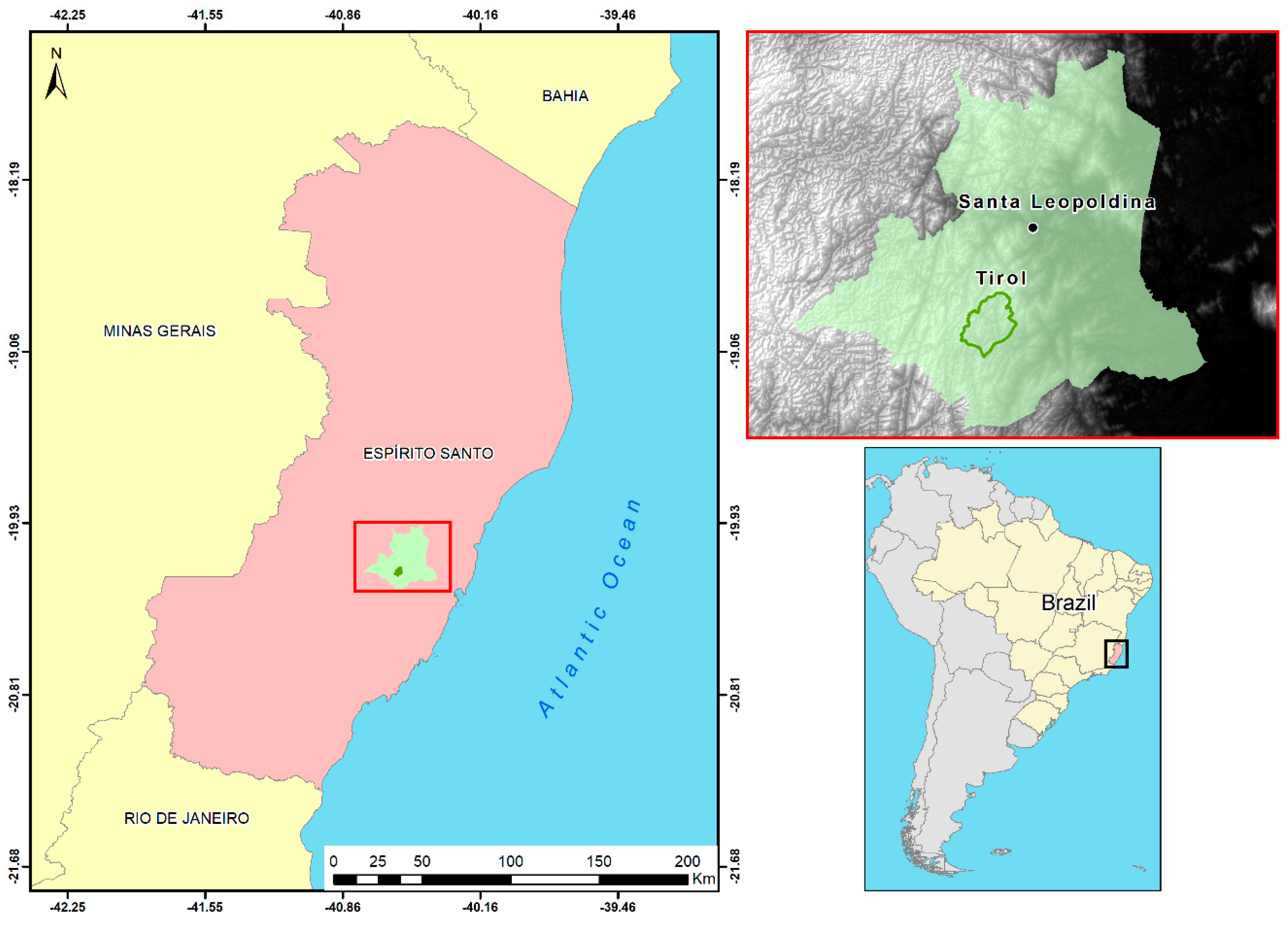
The purpose of this paper is to explore the potential of the Minecraft game environment for urban planning with older and younger children in a rural public school in Brazil. A large part of the Brazilian countryside still suffers from a lack of technology infrastructure, such as computers, smartphones and internet connection, which creates a problematic scenario concerning spatial planning. The hypothesis is that games can enable the engagement of children in urban planning. Urban and Regional Planning in Brazil is based on land use and cover, which means zoning and use and appropriation of space [
1,
13]. Thus, how can games support children in co-designing their future city? Which heritage values do they represent graphically in the game environment? We evaluated the potential of Minecraft applied to urban planning with children by visualizing the selected Brazilian town Tirol in Minecraft. Tirol’s rural center was modeled in Minecraft using open geospatial data in which children were invited to play a significant role in the game narrative and gameplay. Tirol is a small town built by Austrian Tyrolean migrants in 1859 in Brazil. It is considered a rural area because it has no access to the internet and limited availability of computers. Two experiments were designed with a focus on engaging children of this town in co-designing the environment in which they live. The children involved in co-designing and co-creating were between 4 and 14 years old. The first experiment involved collecting geospatial data, treating and modeling Tirol’s landscape, and letting children interact with the digital landscape. The second experiment was based on a scenario approach in a workshop format. The children were asked to change and co-design Tirol’s landscape in the Minecraft gaming environment called Tirolcraft. By redesigning the past, children were given a voice to express what they wish for the future, a controlled expansion into a consolidated town center where everything is in a walkable distance. The quotidian is enriched by their heritage values, such as meetings nearby the church, street play and community gardening. The article concludes with the main findings, a reflection on the results and further research directions.
2. Minecraft for Children’s Engagement in Urban Planning
This section explores Minecraft as a digital gaming tool to engage children in urban planning. Firstly, it discusses the concept of geogames, and presents a range of games that fit into the category. It then presents examples of previous implementations of Minecraft specifically, as applied to urban planning.
2.1. The Concept of Geogames
Geogames may use geo-content (i.e., real-world spatial information) or may be mediated by the geoinformation technology such as geographic information systems (GIS). Geogames as a concept and expression were first mentioned in the literature by Schlieder and his colleagues [
4,
14]. They studied location-based games and how board games can potentially be played in the real-world. Some very successful commercial games, such as Minecraft, Ingress, Pokémon GO, Harry Potter Wizards United, and The Game of Thrones, use a geospatial component in the form of maps, visualizations of geographic context, and places as the central part of the gameplay and their visualizations. Minecraft has evolved into modeling real spatial contexts by its players and represents an example of a geogame with an ability to visualize real-world and its geographic context.
Geogames are an emerging research area that concentrate on the value of place and explore different geospatial visualizations and their implementation in a variety of applications. They may incorporate the poetics of hyper-fiction, becoming a cultural object and a socio-spatial process [
12]. Geogames as an academic discipline seeks to encompass the scientific perspective centered on the phenomenon of urbanization, which investigates the capacity for the fictional representation of reality, with its performative unfolding in digital interactivity. Their characteristics can be summarized as follows [
15]: (1) anchorage in a certain place, in which the game environment and spatial components can be represented and visualized; (2) focus on solving a spatial problem relevant to the citizens of the selected place;(3) inclusion of rules and elements of enjoyment to attract citizens to play and continue to return to the game; (4) enabling the engagement and participation of citizens in an urban planning process.
A first-of-a-kind book on Geogames and Geoplay was published in 2018 with a collection of different perspectives on geogames [
3]. The book’s contributions range from an introduction to the Geographic Information System-Multiplayer Online Game framework (GIS-MOG) by Ahlqvist and his colleagues [
16], building on their previous work [
17] to present OriGami—a learning game to improve spatial orientation skills by youth—and a demonstration of the use of geogames in urban planning by the design of a consensus-finding game YouPlaceIt! [
18].
2.2. Minecraft as a Geogame
This article concentrates on Minecraft as the central modeling and research tool implemented to enable youth engagement in urban planning processes. Minecraft is a block-building hit game created by Mojang in 2009. It is the second best-selling video game in the world (behind Tetris) with more than 150 million copies sold. Due its success, Mojang was bought by Microsoft for 2.5 billion dollars in 2014. The three-dimensional game environment, which is purposefully “pixelated” (polygonal), graphically enables the player to interact with space by building or destroying about 500 types of colored block. Minecraft works similarly to the brick-by-brick building logic of Lego. A few very successful games such as Minecraft, Tetris, and Lego build their representation and spatial language on blocks. They implement a block-building and destroying logic, which indicates that simulating complex issues in a simple spatial logic and a playful way is attractive to players.
The purpose of Minecraft is to enable the player to build creative structures, such as buildings, urban parks, streets, sidewalks, entire cities and landscapes, or even elements of the environment such as trees, forests, plantations, relief, rock outcrops, soil, and subsoil. These constructions can either be based in real or fictional spatial contexts. In this sense, it enables the player to create the environment that represents a place, a city, a landscape, a continent or even the planet Earth. It can be played by one or more players (if it is available online, in a multi-player mode), in a real territory or in an environment created by the players. The player may use available resources in an imaginary world to convert them into building materials, while defending herself from computer-controlled monsters—if she plays in the survival mode [
19].
From the success obtained, recent scientific research started to explore educational uses of Minecraft, such as the new application Minecraft Education Edition (MinecraftEdu), launched in 2016. This application has been applied to Science, Technology, Engineering, and Mathematics (STEM) topics, with modifications to make it even more didactic and applicable in the classroom, allowing teachers to track each student’s progress [
20]. It includes new blocks that help teachers demarcate each student’s built area on the map. It is also possible to include a whiteboard to write the class theme, and insert announcements and task guidelines. Google Cardboards glasses can be used for a virtual reality experience. Students may develop skills such as creativity, leadership, differentiation, collaboration, digital citizenship, fun and engagement [
21]. It has the potential to be included in schools’ pedagogical curricula [
22] to give young people a tool to constitute and integrate the digital society.
2.3. Minecraft: Examples of Implementations
Despite these initiatives, the available literature on the use of Minecraft as an educational game is still limited [
23]. This scarcity is even greater with regards to its application as a geogame in the areas of architecture, urbanism or geography, for instance [
11,
24]. In the example of the Block by Block project/game that can be classified as a game for change or a social impact game [
25], which may address complex social issues such as poverty, racism, discrimination, war and peace, human rights or disease. The purpose of Minecraft as a geogame platform may be to raise awareness and foster critical thinking, integrating data, history and memory of real contexts, with a focus on education and public opinion. It can also support the development of alternative designs for the future of the places.
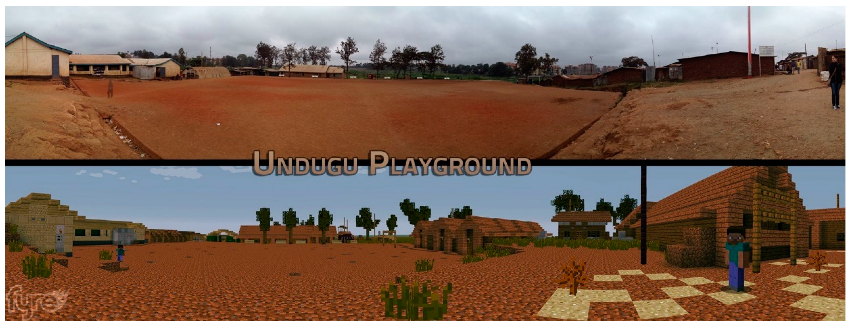
The goal of Block by Block, a Mojang-Minecraft-UN-Habitat initiative, is to empower communities to reconfigure neglected urban spaces into vibrant places. It focuses on the social dimension of planning according to UN-Habitat’s mission, consonant with UN’s Agenda 2030, in particular, with sustainable development goal 11, “Sustainable Cities and Communities”. Their first experimented was held in Nairobi, Kenya, in 2013. It concentrated on solving issues of unsustainability and conflict of interest among different stakeholders. The methodology centered on the use of Minecraft as a tool for visualization and collaboration, especially with young people, who usually do not have a voice in planning processes. Immersion in three-dimensional models aimed to substantially improve the participants’ level of spatial understanding.
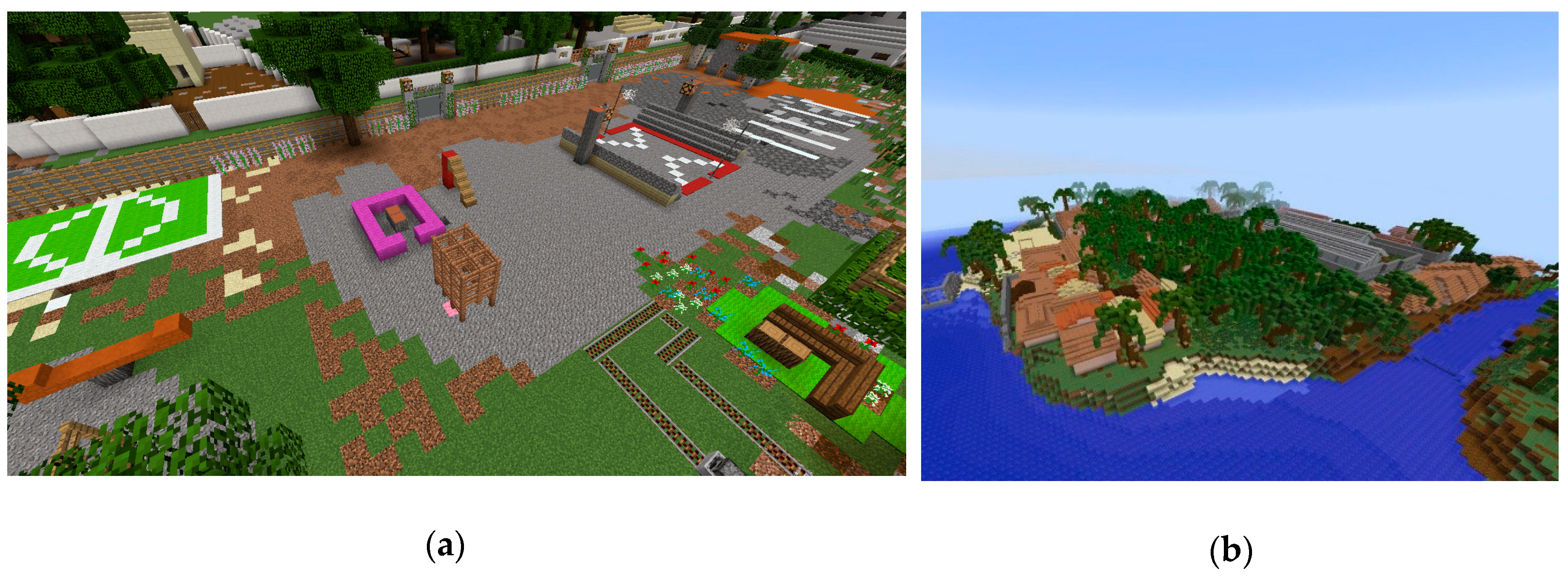
Figure 1 shows the present context and the scenario of a playground design in Minecraft by young people in Undugu, Nairóbi, Kenya. Implementations of other places were funded by the Block by Block project, including the public space design of Accra, Ghana and the redesign of a part of Les Cayes, Haiti, shown in
Figure 2. All images were made available online on the Block by Block website (
https://www.blockbyblock.org/resources).
The “Geocraft NL Project” is a collaborative initiative of researchers from SPINlab (Vrije Universiteit Amsterdam), GeoScience Center GeoFort and Geodan. It integrates an environmental education curriculum in many schools in the Netherlands, and it is already expanding to Poland, where the UN Environment office is based. This confirms the potential of Minecraft as an educational tool which can be used in secondary schools. The team used GIS applications to model three-dimensional objects in Minecraft. These objects were generated with public data, representing trees, streets, rivers and buildings in the Netherlands. Young people were invited to contribute to the project by detailing the building materials and colors of the city.
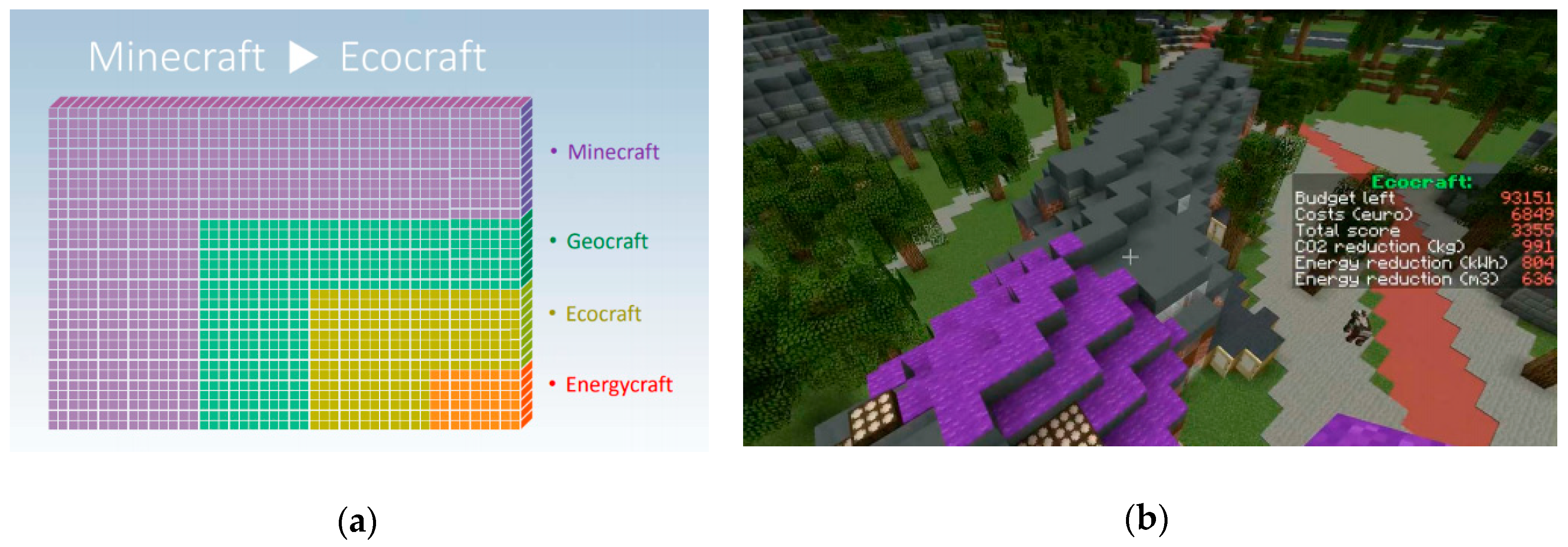
Similarly, Ecocraft [
28], another initiative in the Netherlands, funded by EduGIS Foundation and UN-Environment, focused on using Minecraft to experiment with planning issues such as energy, waste management and transportation. A conceptual image distinguishing Ecocraft from Geocraft is shown in
Figure 3a. The gaming environment was modeled with the use of free and open source environmental data, in line with Principle 10 of the Rio Declaration on Environment and Development, which advocates the right to information, public participation and access to justice as pillars of environmental governance. Impact models and future scenarios, in order to provide information regarding the players’ budget and environmental impacts of activities, were added to the Minecraft gameplay. This initiative promoted a weekend-long workshop that gathered 500 young participants in Amsterdam Arena stadium. The focus of the experiment was to raise environmental awareness among young people. The players were able to experiment with their budget and visualize the environmental impacts of their design decisions, as shown in
Figure 3b. All images were made available online by the Inspire EU funded project (
https://inspire.ec.europa.eu/).
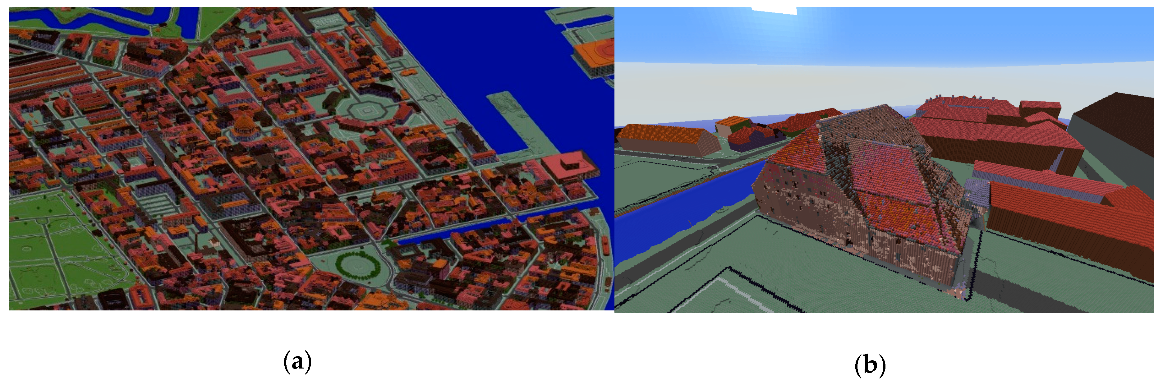
Similar to this, GeoBoxers, a Danish company, modeled entire cities and countries in Minecraft. Examples of the modeled cities include Copenhagen (
Figure 4), Denmark, and the Białowieża Forest in Poland [
29]. GeoBoxers have experience with all kinds of geospatial data and Minecraft models of all scales, from 4000 billion blocks covering the whole Denmark to one single building measured by drones and modelled in 30 cm blocks. The company’s modeling methodology uses GIS software and is based on an automatic algorithm building generation process that uses Open Street Map data. They modeled the old Christian IV’s Brewhouse in Copenhagen, shown in
Figure 4. In the article “Connecting 3D models and GIS with Minecraft” [
30], the author argued that community collaboration strengthens the sense of belonging and enhances consensual design outcomes. He stresses that young people are generally excluded from urban planning, and that Minecraft is a powerful tool that can change that.
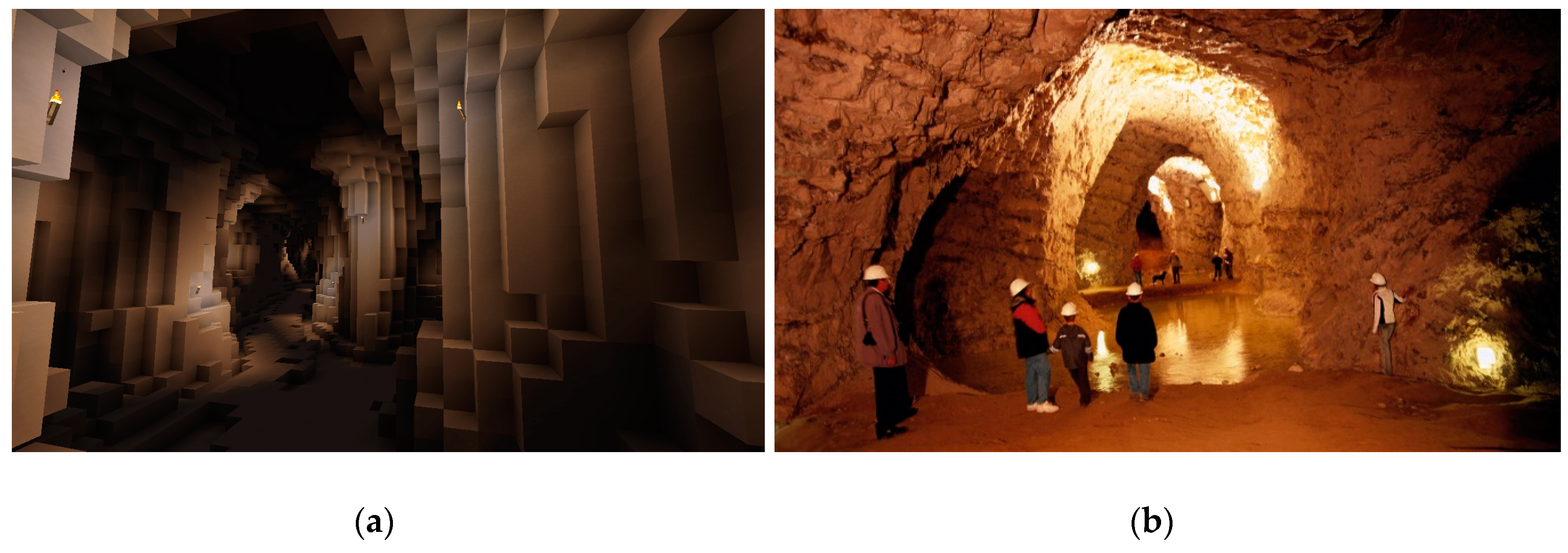
Another example is the virtual representation of Viborg city, northwestern Denmark, which holds the largest limestone mine in the world (
Figure 5). The project explored Minecraft’s potential of underground by modeling to show its use in physical geography studies. The mining and geological data were collected from LiDAR (Light Detection and Ranging) technology. All images were made available online by Geoboxers (
https://www.geoboxers.com/).
Minecraft’s geogaming potential went global at Habitat III, in Quito, Ecuador, with a discussion panel dedicated exclusively to the tool “Using Minecraft for Community Participation in Public Space Design”, held on October 20, 2016. The panel discussed UN-Habitat, Mojang and Microsoft initiatives regarding civic engagement in public spaces’ design, focusing on the participation of youth, woman and slum dwellers. Thus, regardless of citizen involvement or the fact that there are places where there are no computers or even internet, it is possible to conduct and engage urban planning experiments in Minecraft, with participation of citizens of different ages, genders and cultures, if the required equipment is provided during the workshops [
12,
32].
2.4. Identified Research Gaps
The projects in Minecraft developed to date show the potential of this game environment. The research presented in this article builds on previous experience and identifies three research gaps which are addressed in this paper. Previous experiments such as Geocraft NL and Block by Block have engaged young people in the design process, but never as young as 4–7 years old. They also did not engage very young children in the process of the co-design and co-creation of their environment. In synthesis, the three research gaps identified for the research presented in this paper were: (1) engaging older and younger children in urban planning; (2) children as co-designers in planning process; (3) engaging children in rural areas.
2.4.1. Children’s Semiotic Manifestations
This sub-section addresses the research gap (1), engaging older and younger children in urban planning. The hypothesis is that either younger or older children can participate in the planning process and contribute in the co-creation process. There are five manifestations of the semiotic (or symbolic) expression with which children may communicate and they may include: (a) deferred imitation; (b) symbolic play; (c) drawing; (d) mental image; and (e) memory [
33]. The gaming environment of Minecraft allows younger and older children to manifest and develop their semiotic representations through the fifth order of complexity.
Imitation can be done by simulating sensorimotor movements with their avatar in the Minecraft game. Symbolic play can be done by simulating the Minecraft game environment as their actual everyday life, in which they can become immersed and spontaneously express pleasure and/or disinterest. Drawing (or graphic image) can be implemented in the form of designing new architectonical elements in the digital landscape of Minecraft. Mental imaging can be done by consciously designing structured architectonic elements with a combination of blocks with a determined color and built material. Evocative memory or recall is done by redesigning memory-images of local heritage values [
34], or rupturing with the existing values by designing new ones.
2.4.2. Children, Remembrance and Now-Time
This sub-section addresses the research gap (2), children as co-designers in planning process. The hypothesis was that children are valuable to the planning process, and that they are able to co-design, collaborate, and envision changes in the place in which they live. Children have a redemptive possibility of the past through the life-and-sense-embracing immersion in the world of sensation, absorbing and being absorbed by the present moment [
35]. Using a Minecraft scenarios approach may enable children to explore the twin aspects of redemption in Benjamin’s writings: remembrance and now-time as a task of childhood [
36]. There is an emancipatory potential held within the development of historical consciousness in children. Minecraft is a tool that may allow children to explore different choices to their precedents. They are able to explore their ancestors’ planning choices and experiment with their own ideas.
The notion of remembrance raises three interlinked sets of questions: (a) justification for remembering the past; (b) what should be remembered; and (c) what kind of existence the past has [
35]. The justification relates to the subject, for instance, setting Minecraft as a scenario environment for children to revisit the past and better understand their ancestors planning choices. What should/can be remembered relates to the object of remembrance, for instance, the heritage values that shaped the architectural ensemble. For instance, children’s representations in Minecraft can show a redemptive quality of the past, in cases where they choose to relate to it through the design.
2.4.3. Rural Children in the Urban Revolution
This sub-section addresses the research gap (3), engaging children of rural areas. The hypothesis was that children in rural areas prefer living in cities and therefore have a tendency to leave their rural town. Rural people have an important role in the complex play of planning. The rural community is a form of social group, organized historically according to the determined norms of families tied to the land [
9,
10,
11]. Geogames, in this case, can become a method of historic–genetic analysis that may enable people to measure discrepancies in architectural typology and settlement form. This measurement can be based on the metrics of architectural elements designed in the Minecraft game environment.
Minecraft was shown to be useful for heritage documentation in rural areas facing urban expansion and transformation. The total urbanization of society is an inevitable process that demands new interpretive and perceptual approaches. The urban revolution is virtual today, but will be real in the future. That is why it is relevant to involve rural children in planning processes, because they will eventually be the decision-makers in the urban revolution. Therefore, the experiments in Minecraft explore individual creativity in shaping the realities and possibilities of urban space in rural communities.
2.5. Research Questions
The main research questions identified for this research appeared as follows:
- -
Can Minecraft game environment be used to engage young and old children from rural areas in urban planning? Specifically, Tirol town in Brazil;
- -
Can children interact with the Minecraft game environment and co-design the environment in which they live? Specifically, students from a public school in Tirol town in Brazil;
- -
What are their values and how do they express them regarding their hometown?
In order to be able to answer these research questions, we selected a study case in a rural landscape in Brazil. We then modeled this landscape in the Minecraft game environment and let young children to interact with it. The following section describes the selected study case and the visualizations in Minecraft.
4. Testing Minecraft with Children: The Tirolcraft Experiment
Two subsequent experiments were conducted with the goal of engaging children in testing Tirolcraft as a playful gaming platform and enabling a discussion about values. Schoolteachers supported these activities and included them in their teaching programs. Children could either (re)produce the Tyrolean built fabric as it stands or break with this logic and propose a new land use structure in response to perceived errors made by previous generations. Each experiment used only one computer laptop and one Minecraft license and was played offline, as there was no access to the internet.
4.1. First Experiment: Playtesting Minecraft
The goal of the first experiment was to analyze children’s interactions with Minecraft in order to prepare them for the second experiment. The analysis focused on observing their understanding and recognition of the landscape, their ability to build (and willingness to destroy), and the usability of Minecraft. The analysis also covered two different age groups that were invited to play during classroom hours. Involving all the children in the school was deliberate, to build trust for future activities.
The experiment was designed as follows:
- (1)
Presenting Minecraft and its functionalities;
- (2)
Explaining the goal of the experiment: redesigning Tirol;
- (3)
Designing a new city;
- (4)
Discussing the final design scenario.
The model in Minecraft presented the natural landscape of Tirol on a single computer laptop. The experiment took place on 6th and 7th June 2016 and involved 30 students between 4 and 11 years old from Tirol’s public school. Children were divided in two groups—younger and older children. This was a rapid design workshop in which each group of children could design their village together for 30 minutes.
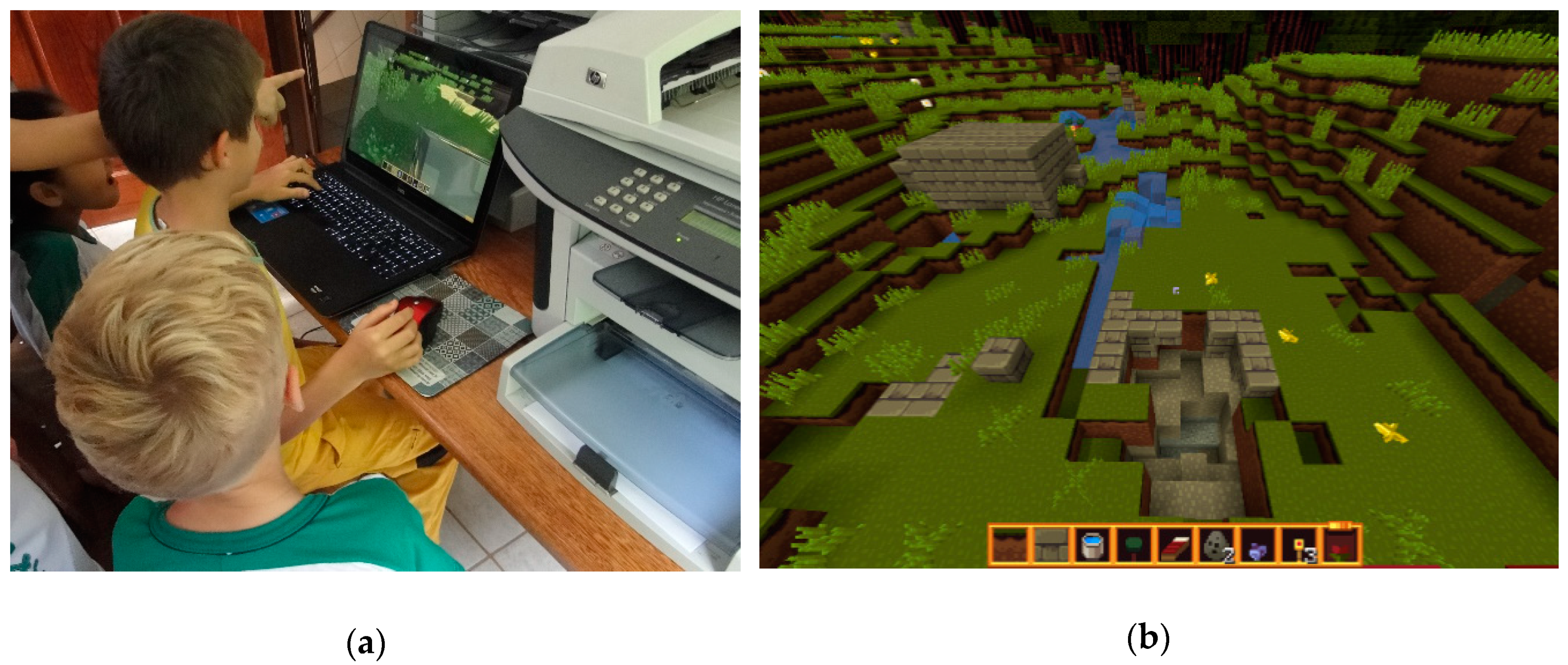
The younger group was composed of 12 students between 4 and 7 years old (
Figure 9a). Surprisingly they showed a good understanding of the game, and maintained attention throughout the whole activity. Part of the group was the photographers and the other part was the designers. They could exchange roles when they wanted to. The first designer was taught how to use the game application, and she then became the tutor for the next one in line. This strategy left the researcher and facilitator free to write down observations of children’s behavior and interactions with the game. Children could ask for help at any stage of the design process, and were encouraged to be as creative as they wanted.
As a result, the younger kids’ proposals included: (a) buildings with materials related to the local environment, such as wood and stone; (b) playgrounds with equipment for playful activities; (c) a waterfall; (d) a cavern; (e) a square in front of the school and the church, a lake, trees, flowers, animals, and a playground.
Figure 9a shows a group of the younger kids at work.
Figure 9b shows their design.
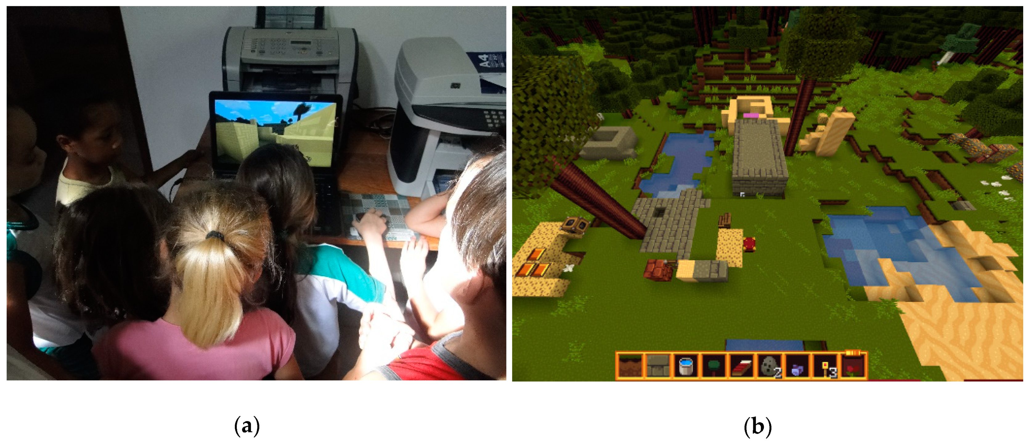
The group of older children was composed of 18 students between 7 and 11 years old (
Figure 10a) and showed an eagerness to explore the game by expanding the design area and diversifying the built environment. Some of the older children’s designs were: (a) new buildings, such as a bigger school; (b) vegetation trees and gardens with flowers; (c) a cavern; (d) a new square in front of the school and the church with a lake, trees, flowers, animals and playground with places for bicycle, rollerblades, kick scooter, and a place to skate (
Figure 10b).
4.2. Second Experiment: Tirolcraft—Redesigning Tirol in Minecraft
The second and main experiment focused on the older children’s group at the school. The older children from the first experiment joined the second one, which proved that, on a long research project, building trust with the school and involving as many children as possible can be an asset. This second experiment took place on October 19th and 20th of 2017, and it involved 14 children between 9 and 14 years old.
The task was to answer the following question through the design: “If you were your ancestor from Tyrol, Austria, arriving in a mountainous region, a forest far from the city, what would you build first?” Two thirds of the group responded to the question by expressing the need to build a house and a farm, to have shelter and food. This pointed to their sense of continuity regarding the heritage values of the Austrian migrants from 160 years ago. One third of the group also mentioned the need for playful structures.
The experiment was designed as follows:
- (1)
Explaining the goal of the experiment: redesigning Tirol according to their values;
- (2)
Designing a new Tirol as if they were the first one to get there back in 1859;
- (3)
Discussing the final design scenario.
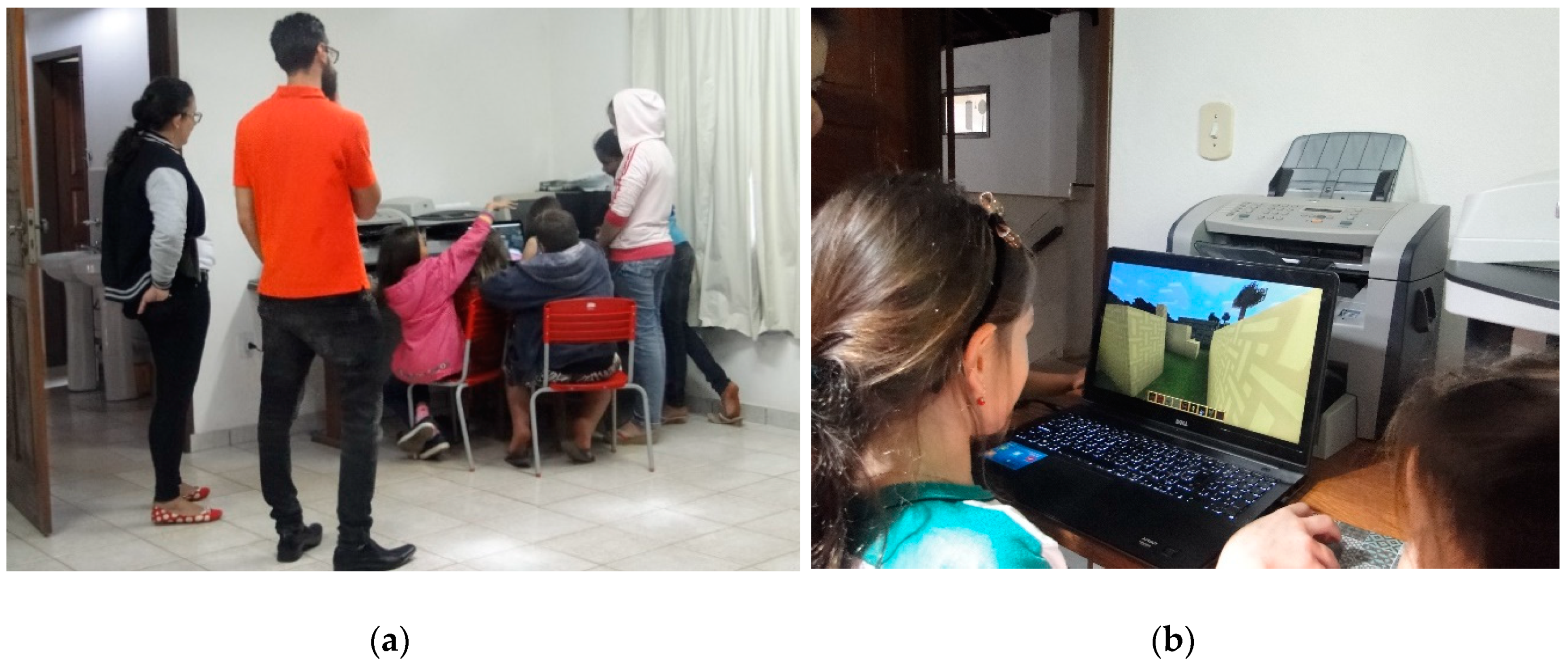
The timing constraint in the last experiment was related to having only two lectures of 1 hour each to explore the design potential of Minecraft with all students of the school. They designed several structures jointly in 30 minutes; what if each child had 30 minutes individually? The researcher arranged with schoolteachers that each of the students would have up to 30 minutes available to design. In the beginning of the process, a group of children was placed around the laptop watching one of them designing (
Figure 11a). It was not initially supposed to be a collective decision, but a combination of individual decisions. After this was noted, each child was given the computer laptop for herself/himself and the researcher and facilitator used this time to write down notes on the child’s behavior and designs, as well as to take pictures of the process and the actors (
Figure 11b).
Children focused their attention on the design of a house, which involved choosing the location. This required reflection on topography, road width and visibility to other buildings. They were excited about having the power to design their own house. While doing so, they would speak about their real houses or a house they have seen in the closest city, Santa Leopoldina, or in Vitória, the capital city of Espírito Santo State. Some of them started to decorate the interior of the house while others chose to start changing land use and cover. Despite their desire to design more of the areas for farming, gardening, pasture, animals, trees, flowers and water well, it was not possible to extend 30 minutes for each child due to the teaching schedule of the school.
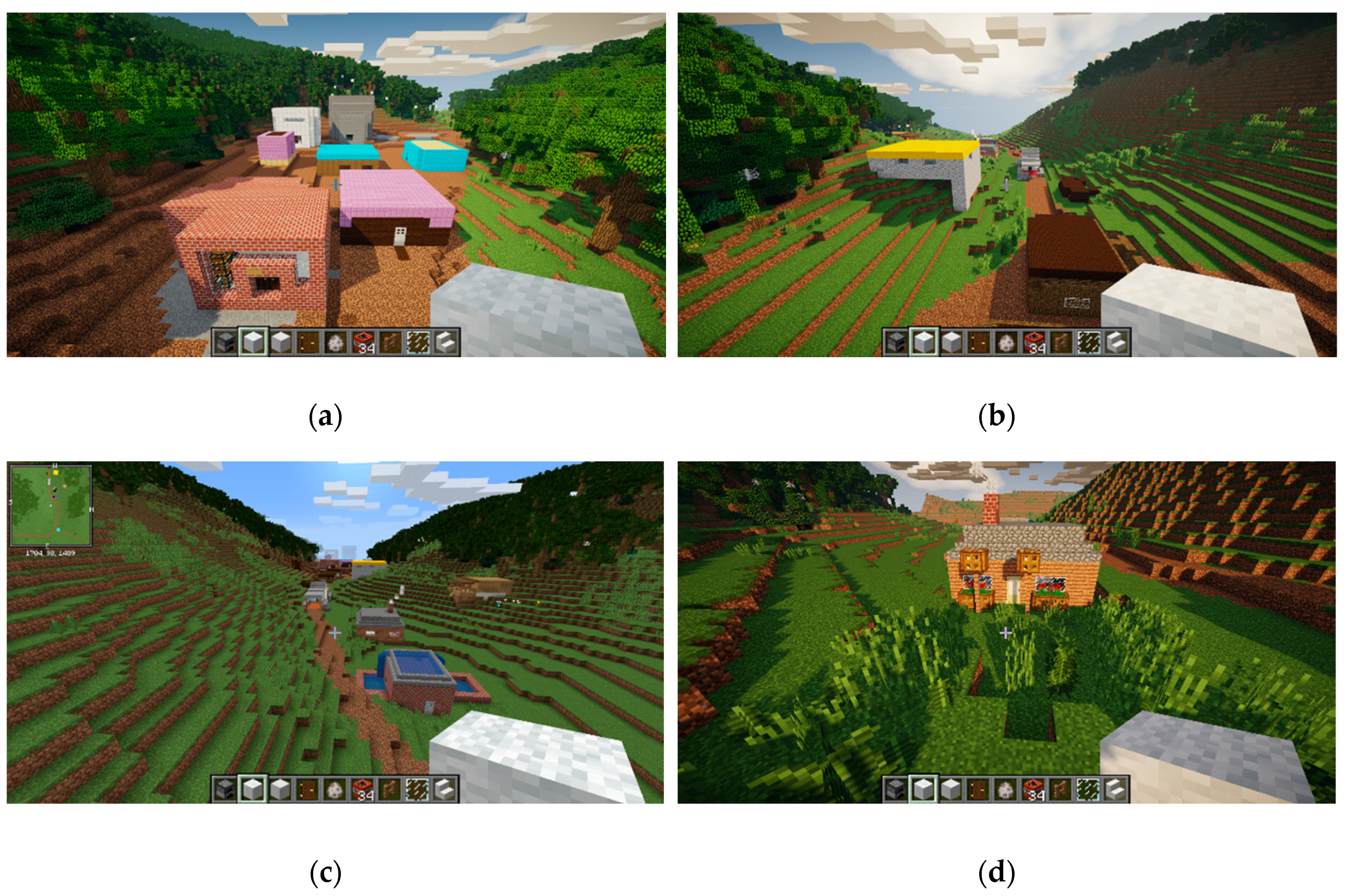
Figure 12a shows the designs of the first houses. In the background of the image, the church is gray and the school is white.
Figure 12b shows a particular architectural design—a modern-type house in gray and yellow.
Figure 12c shows a house reusing rainwater with a water well.
Figure 12d shows the garden of a colorful house.
4.3. Testing Observations
The final designs revealed the development of orientation-related skills and knowledge in architectural history, urban planning and physical geography. Children were able to access their design using a small top-view map on the Minecraft screen, as shown in
Figure 12c. They were able to locate their houses; correlate the map with real landscape; align the digital, real and mental mapping; comprehend basic cartographic principles such as metric proportion, scale, coordinate system, symbols and legends; better understand architecture (building materials, implementation, scale, color, typology) and the landscape (geomorphology, relief, soil, water resources, green areas, landscape typologies).
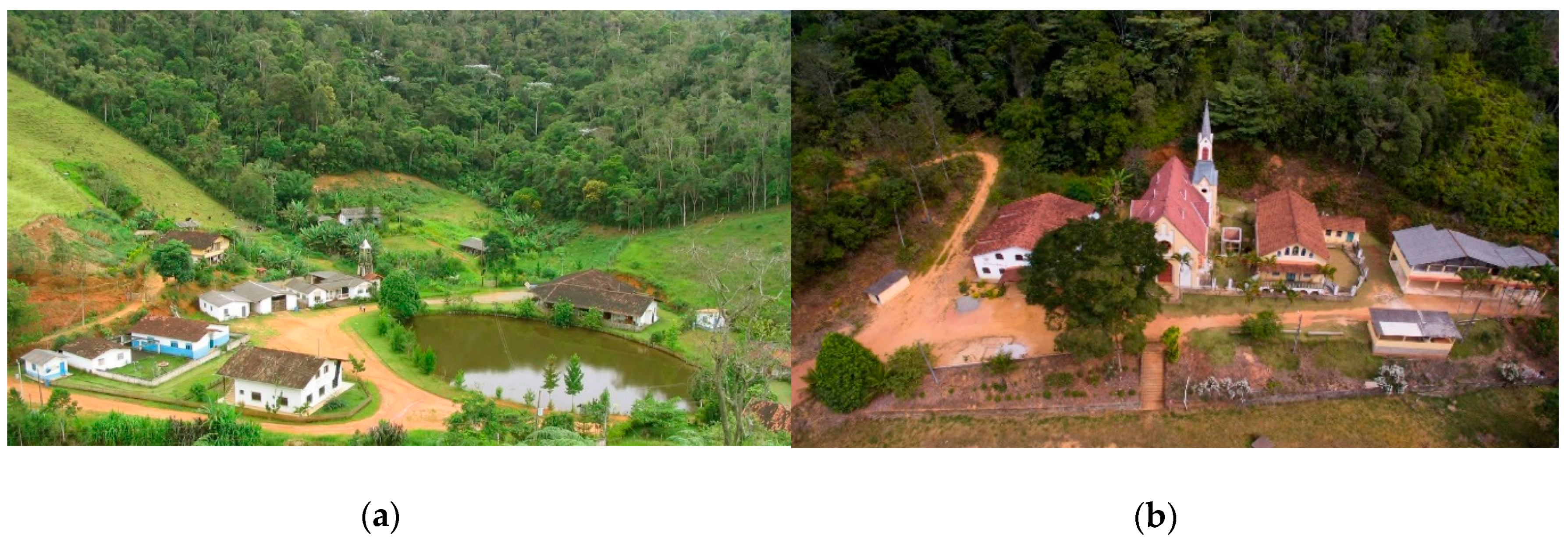
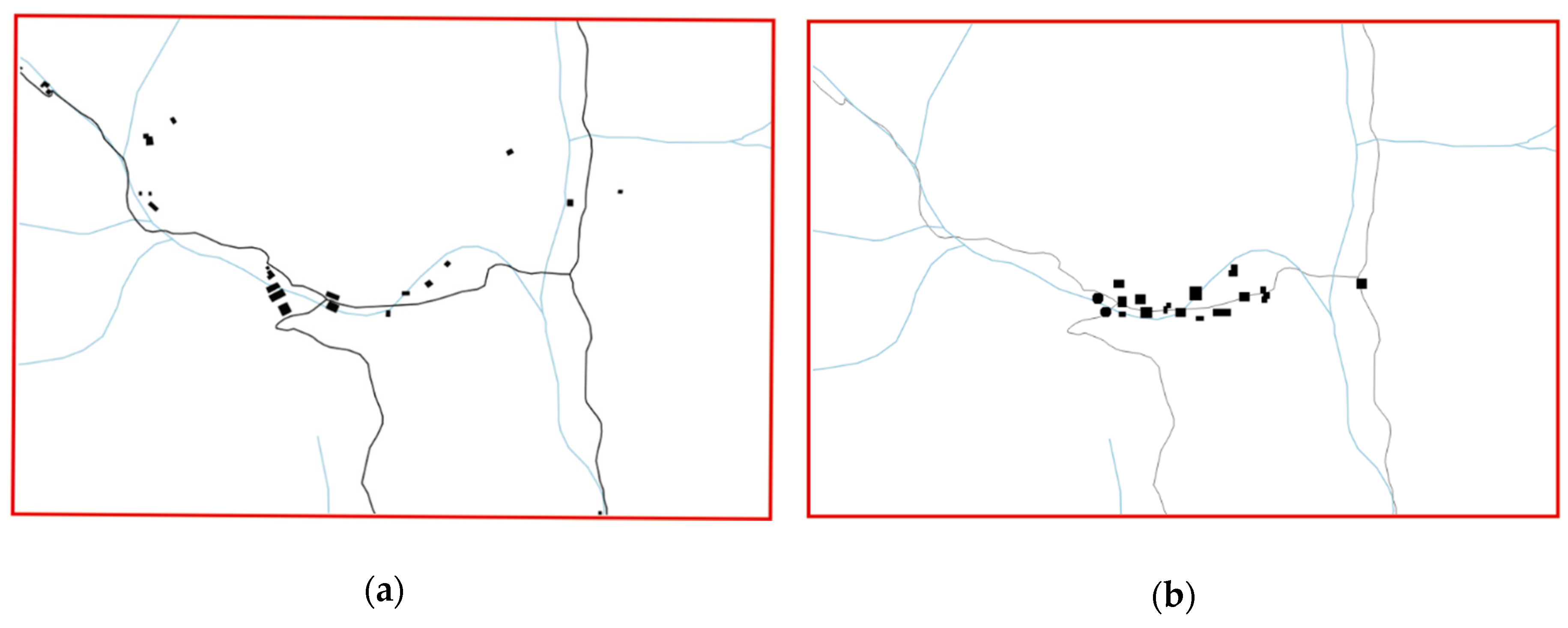
Figure 13 shows the contrast between the isolated form of settlement in Tirol in reality and the grouping of buildings designed by children in Minecraft.
Figure 13a represents the present situation and 13b represents the children’s design ideas. This collective vision for Tirol as an urban consolidated center is the usual settlement form found in the Tyrol region in Austria.
5. Discussion and Reflection
The experiments focused on testing the potential of Minecraft as a geogame for children. They concentrated on the children’s understanding of the landscape and their ability to express their own values. The experiments in Tirol, Brazil aimed to empower children to become active stakeholders in the planning processes.
5.1. Reflection on the First Experiment
We observed that children were fast learners of a gaming engine such as Minecraft. The tridimensional environment and the bricked logic of the game seemed to be compelling to them. Only a few of them had played Minecraft before. Most of them use tablets to play games. They mostly do not have computers, game consoles or cellphones at home. Tirol is a town with limited access to the internet and technology. The fact that their own place was modeled in the game resulted in a lively interaction with the game. It enabled them to contribute to the co-creation of future scenarios in their hometown.
Both age groups in the first experiment showed a good comprehension of the game mechanics during the period of the activity, and were able to design houses, squares, playgrounds, tunnels, and lakes. The designs of the younger children were more simplistic. They composed a couple of buildings connected with a small river and random play furniture. The older group showed a more complex mapping ability through a variety of architectonic ensemble, and a better sense of symmetry and the distribution of elements. They showed a wish for density, in contrast to the actual layout of Tirol.
5.2. Reflection on the Second Experiment
The second and main experiment revealed that children reproduced the heritage values related to their rural landscape. The game environment was designed so that children would have a chance to revisit the challenges of their ancestors when they first entered the region. Their ancestors had to rapidly build shelter and begin to farm in order to pay for the land in a maximum of ten years. Children validated their choices by choosing to build a house and a farm, their heritage values’ pillars.
They kept shelter and food as the primary aspects of their ancestors alongside the scale and proportion of the house. They made different choices regarding rural morphology, from isolated large properties to conjugated small properties and from a spread-out urban center to a compact one. They also directed urban expansion into the valley and not to the hills.
Each child designed, at least, a house. The final design shows 16 buildings, in which there were 14 houses, one church and one school. The colors of the buildings demonstrate a playful element in the children’s design. Play is not only an action but an action triggered by architecture and design. In other cases, the color represents the constructive materials, such as wood and stone, that exist in reality. The design functions as a simulation aspect of the gaming approach. The representation of a house becomes a reflection of reality, e.g. materials, or a projection of the ludic, e.g. colors.
Notably, while most buildings, with regard to typology, construction materials, implementation, look similar to the rural house of the German-speaking Tyrolean region in Austria [
40], some buildings designed by children refer to the modernist architecture movement [
45]. An example is the modernization of Stubai, south of Innsbruck, the main place of their ancestors’ origin. The older children excelled in the aesthetic and functional appeal in modeling, modifying, and arranging landscape elements (e.g., land, plants, and water).
Although children had no guidance or recommendations regarding the ecological dimensions of designing their town, they built natural light-centric buildings incorporating rainwater re-use, community gardening, and vegetation conservation. This was similar the Ecocraft experiment that the Dutch initiative mentioned previously, and confirms the potential of climate-led approaches to Minecraft and the tendency of children to consider these aspects in design decisions. Children chose to build an urban center with visibility from one residence to another, and to the church. It is a combination of the form–function–structure that influences their collective values alongside their everyday life in Tyrol in Austria [
46]. This was a major step forward in relation to the previous experiment, because it was possible to understand the choices and the visions of children for their town. The design results represent an exceptional set of qualitative and quantitative data for urban planning.
Both experiments supported the development of new skills by challenging children to explore and be aware of the rural fabric in their town concerning the architectural ensemble [
47], rural design [
9], and cultural landscape [
42]. The experiments raised awareness through specific tasks, such as building new architecture, agricultural farms and changing rural morphology.
6. Conclusions
The digital game environment built in Minecraft, Tirolcraft, demonstrated that using a game as a tool can motivate, inspire and engage very young and older children to participate in the urban planning process. Their pleasure, engagement and focus when participating were observed in two experiments described in this article and conducted in Tirol, a small rural village in Santa Leopoldina, Brazil. This research presents evidence and answers the main research questions set for this paper. The Minecraft game environment can be expanded and developed in a way that it becomes the central motivating platform which can engage children and youth in active engagement, collaboration and generation of ideas for the future of their hometowns. Children were able to interact with the designed platform and were immersed in experimenting with this platform, which enabled them to share their current problems and visions for the future. Children were able to bring their ludic quality, and an ability to play and enjoy, into the process of co-creation. Younger children contributed simpler designs, but these are also valuable for the planner and designer. In contrast to that, older children designed more complex structures in their visions for the future of their places. This has the value of giving children a voice, and the possibility of expressing themselves and actively contributing to urban planning processes.
The two experiments discussed in this paper prove that Minecraft as a gaming environment and platform can be used with primary school children. In their suggestions for the future, the children involved in these experiments showed that they value a balance between the built and the natural landscape and walkable distances to everyday facilities. They were keen to explore the reality after being immersed virtually in the game.
The two experiments demonstrated that Minecraft could be used as a tool encouraging democratic and inclusive civic participation. The engagement was combined with the introduction of a ludic experience that enabled a relationship with the places as well as the toys. The game environment was able to break down complex issues into simple ones. The first experiment showed that Minecraft is a suitable tool for children to engage with the design processes, even very young ones. It also revealed that heritage values based on the long past can be reproduced in a contemporary way. For instance, kids kept the typology of a house and turned it into a monument of colors, transparency (bringing natural light and therefore saving energy) and vicinity to other buildings.
The experiments also revealed that only one computer could be suitable for engaging three children at a time. Using only one computer resulted in a slower pace of the experiment. It did not allow the whole group of children to play together in the same game environment at the same time. Using one computer per child may allow children to detail more of their heritage values and design the urban expansion of the actual rural center. This needs to be tested in the future.
The schoolteachers also enjoyed having a new tool such as Minecraft in their pedagogical program. They wanted the researcher to return regularly, because they did not feel comfortable using Minecraft in teaching on their own. Although they recognized the relevance of having technology embedded in the curriculum, they felt that the state should provide computer equipment and training to them. One of the eldest teachers in the school stressed that she sees the potential of the game to teach history through architecture, geography through the exploration of coordinates and map visualization, math and Portuguese language. Children enjoyed playing geogames. Children were motivated by geogames. Children had a tendency to get distracted while they were not playing. Minecraft as a geogame became a participatory urban planning tool, a block-building thinking logic that allowed children to recreate their town digitally. This new possibility of engagement may encourage other social actors to participate actively in planning processes.
New questions arise for Minecraft and geogames related to building smart cities and communities. For instance, could these digital natives foster a culture of planning that will provoke a ripple effect to activate adults, elders, and other sectors of society? Could they interact, plan and manage their cities cooperatively in a democratic and more efficient way? These open questions may initiate additional experiments addressing different types of games, multi-player aspects, cooperativeness and/or competitiveness in the game environment. Minecraft is not the only popular game capable of engaging children and young people. Lego Worlds, Skylines or Unity-based applications could be used as tools in a participative planning process. The multi-player experience may allow discussion and exchange among multiple players engaged in the process of reaching a consensus on the design. The cooperative and/or competitive concepts of games can enhance knowledge and empathy towards differences in views, values and opinions.
Relatively little academic research has been conducted on what children can teach the urban planning discipline. In the experiments presented in this paper, children tended to prioritize their inherited values, such as housing, farming and gardening, for the time-constraint of the game design. Children’s plans densified the rural center of Tirol, bringing an urban form to it that was similar to the Tyrolean towns in Austria. Their plans were different from Tirol’s real socio-spatial context in Brazil, characterized as an isolated settlement. What else can children teach urban planners? More research is needed, not only on how children and youth can be engaged, but about what can they contribute and in which alternative ways they may feel compelled to contribute to the creation of their future, and of livable and sustainable environments. The children in Tirol, Brazil planned a city of integration, sustainability and integration between the built and the ecological dimensions of space, and a place with a sense of community and belonging. They wished for the future rural area to become more independent from the city by having more infrastructure and a variety of land uses. Local authorities and planners can now search for the most appropriate use of the land combined with the built environment; the land use that can bring ecological, social and economic benefits to the place and the whole region.
Let us engage children and youth into urban planning processes and the co-creation of sustainable environments. Geogames can be a tool to be used and experimented with. They represent a set of innovative possibilities and methodologies, of which Minecraft is one, that can enable ludic, immersive, creative, engaging environments that initiate, engage, and provide digital environments for children to explore, test, experiment, express and design for the future.


