1. Introduction
Mining and metallurgical activities produce a considerable amount of waste that contains metals and metalloids, usually in high concentrations. As a result, mining waste facilities are associated with soil contamination posing a significant risk to both human health and the environment. According to a recent report produced by the JRC in collaboration with the EEA [
1] the number of potentially contaminated sites in Europe is estimated at 2.5 million, while the identified ones are around 342,000. Moreover, data collected by the European Soil Data Center of the European Commission using the European Environment Information and Observation Network for soil (EIONET-SOIL) suggest that the mining sector is responsible for around 7% of soil contamination in Europe [
2]. The degree of impact depends on the characteristics of the ore and of the waste, the scale of mining, and the mining and beneficiation methods used to recover the valuable minerals.
Some countries have adopted standards related to threshold or target maximum values of certain contaminants in soil. Yet, in many countries, including Greece, no such national standards have been imposed. Furthermore, a point of concern is that the respective standards differ from country to country, according to each nation’s priorities [
3]. For example, the United Kingdom has established limits based on the “end-use” of the site, while the German policy is targeted to the groundwater protection and the Dutch standards mainly address the multifunctionality of soil.
Despite the differences existing between regulations, countries’ remediation strategies have one characteristic in common: they focus almost solely on the elimination of the source of the hazard. That is, soil clean-up is required by means of treatment technologies available (e.g., chemical extraction and soil washing, immobilization, soil handling, etc.). Nevertheless, clean-up costs are often very high, as shown in
Table 1.
U.S. EPA reports indicate similar remediation costs between 5 USD up to 250 USD per ton of soil, depending on the selected method and the target remediation values [
6]. Even with the lower cost, the management of contaminated sites is quite expensive. For instance, it is estimated that European countries should spend around 6 billion Euros per year to deal with contaminated land [
1], and the mining sector’s contribution to the problem is significant.
At the same time, however, these sites contain useful materials that might be recovered under specific circumstances. Τo wit, the continuous resource depletion that creates the need for the exploitation of ‘poor’ ores on one hand and the rapid technological evolution on the other hand may transform existing mine waste dumps into the mines of the future at a known location. This prospective should not be ignored, since the quantities of deposited materials around the world are significant. For instance, according to Kapur and Graedel [
7], the quantity of copper located in all kinds of waste repositories is about 300 million tons, an amount corresponding to more than 30% of the remaining reserves in known ores [
8].
Considering the abovementioned remarks, a complex situation arises in the case of contaminated mined sites, having serious economic, environmental, social, and political implications. On the one hand, there is the need to protect human health and ecosystems from harms related to past mining activities at an affordable cost for the society. On the other hand, remediation measures should be implemented in a way that would allow for the potential ‘ore’ to be mined in the future. In such cases, a risk-based approach may be quite effective in providing an environmentally sound and economically viable solution without jeopardizing the opportunity to recover valuable resources in the future from today’s waste. Risk-targeted methodologies examine the chain of “Hazard → Pathway → Target” and aim to break the links [
9]. In this way, risks can be managed in many ways, e.g., they can be eliminated, transferred, reduced, encapsulated, or retained with respect to an acceptable risk level taking into consideration critical factors of the problem under investigation (e.g., environmental pollution, finance, regulation, social effect, etc.).
By focusing on the risk-based assessment, this paper aims to offer a different view on the issue of mine waste management. To this end, a heavily contaminated area in Greece, for which there are limited remediation funds available, is used as case study. More specifically, the paper illustrates the effectiveness of risk assessment and risk management techniques as a means to implementing immediate, cost effective actions that: (a) minimize health hazards (i.e., cut the pathways via which the hazards are transmitted); (b) allow the safe use of the site for recreational purposes; and (c) facilitate the reverse process in which the wastes could be mined and used as valuable materials in the future. The rest of the paper is structured as follows:
Section 2 provides background information with respect to the site used as case study.
Section 3 illustrates the risk assessment methodology followed.
Section 4 presents the results of the analysis. Finally,
Section 5 summarizes the main conclusions drawn from this work.
2. The Kavodokanos Site
2.1. General Information
The “Kavodokanos” site is located next to the old metallurgical complex of the former “Compagnie Francaise des Mines du Laurium”, adjacent to the city of Lavrion, about 60 km from the Athens metropolis. The broader area is characterized by a unique historical and industrial heritage, since the mining and metallurgical operations, related to the exploitation of the silver and lead ores, started in the year 3000 BC and ended in 1989 [
10,
11,
12]. These ores supported the Golden Age of Athens, and thousands years later contributed to the development of Greek industry. Nevertheless, the intensive and long term mining and metallurgical activities have resulted in serious pollution problems affecting the broader area of Lavrion and the local community.
Solid wastes from the mining and minerals industry were traditionally disposed of, usually in the form of large heaps (dry waste e.g., slags) or slime dams (wastes in slurry form). The area in and around the city of Lavrion is highly polluted and pollution consists of by-products of the industrial activity deposited uncontrollably, such as slags coming from the smelting process of silver-lead ores and various sulfur compounds waste (known as B.P.G. blende-sphalerite, pyrite, galena) derived from the metallurgical beneficiation process of flotation [
11,
12,
13].
According to previous records and research projects (e.g., [
13]), within the borders of the Kavodokanos site, mainly metallurgical slags have been deposited. Those wastes are relatively ‘young’, since they have been gradually dumped during the last 150 years. Another point of concern is that several sandblasting activities have taken place on site during the last 20 years [
13], utilizing the existing slags as abrasive material. Thus, there is a differentiation in granulometry of wastes, since slags, as a by-product of sandblasting process, are much finer materials than typical metallurgical slags.
The nature of the wastes has been confirmed by site investigations. Typical metallurgical slags for the area present black to grey colors and, in rare cases, yellow to brown-yellow colors, indicating the presence of flotation residues. Finally, at several locations, inert wastes, coming from construction activities, have been deposited, while bulky municipal wastes are also present. The disposal site occupies an area of approximately 104,000 m2 and contains approximately 200,000 m3 of waste as estimated by means of geophysical techniques.
2.2. Sampling Regime
The research team investigated the site to assess the extent and severity of pollution. The site investigation included soil sampling from 25 locations from the topsoil (0–0.30 m). Sampling locations were selected so as to cover the largest possible area and reassure the representativeness of the samples. Bearing in mind the gradual deposition of different types of waste through the last 150 years, mixing of samples was avoided and every single solid sample was subjected to chemical analysis. Furthermore, for purposes of quality control, “blind” samples were collected from locations where no depositions were observed and native soil is visible.
Samples were stored and preserved for laboratory determinations by implementing ISO 18512/2007. For purposes of metals and metalloids determination, each sample was prepared for chemical analysis according to European Standard Final Draft prEN13657. Further analysis of each element was conducted according to DIN EN ISO 11885 and DIN EN ISO 17294, by utilizing Inductively Coupled Plasma Spectrometry (ICP-OES-Prodigy-Teledyne, Leeman Labs, 110 Lowell Road, Hudson, NH, USA), Inductively Coupled Plasma Mass Spectrometry (ICP-MS) and Atomic Absorption Spectroscopy (Polarized Zeeman Atomic Absorption Spectrophotometer Z2000 series, AAS-Hitachi, Tokyo, Japan).
Following the aforementioned procedures, the elements Arsenic (As), Cadmium (Cd), Copper (Cu), Lead (Pb), Iron (Fe), Zinc (Zn), and Chromium (Cr) were measured in each sample. Each measurement was replicated twice, for different samples and the difference between the two samples was less than 5%.
The particular elements were selected based on the previous experience of the research team, with respect to waste sampling and measurement in the broader area of Lavrion. Furthermore, relevant literature has indicated those metals and metalloids as the most common among the metallurgical waste [
11,
12,
14,
15].
In order to clarify the origin of the waste (i.e., slags or flotation waste), apart from pollutants concentrations, the determination of additional physicochemical characteristics of the soil was necessary. In view of that, pH (ISO 6588-Mettler-Toledo pH Analyst) and total sulfur content (LECO SC 144DR) were specified.
Chemical analysis results are presented in
Table 2.
Factors affecting metal retention and mobility in soils include pH, initial metal concentration, soil sorption capacity, organic matter content, age of contamination, and the presence of different inorganic contaminants in soil [
16].
Metal concentrations in our samples are extremely high (
Table 2), posing a significant hazard for human health and the environment. Soil under consideration is characterized as unusually polluted according to ICRCL classification of soils (ICRCL, 2001—
Table 3), especially for As, Pb, and Zn. Even for Fe, which is not considered toxic, its high concentration may significantly deteriorate groundwater quality [
17]. On the other hand, the age of the contamination renders soil-metal and metal-metal bounds less mobile due to the formation of numerous surface complexes of solids [
11]. Moreover, the metal sorption capacity of soil is exceeded; conclusively, pollution is present as discrete metal-mineral phases and is not bound to specific soil components [
18].
Metals and metalloids concentrations are characteristic of slags rather than flotation or other type of metallurgical waste [
12]. Moreover, soil pH was found to be slightly acidic to neutral (
Table 1) while sulfur content was relatively low (below 2% in all samples). Those results indicate that waste mainly consists of slags, since flotation wastes contain much higher sulfur concentrations and their pH is usually significantly lower [
10,
11,
14].
Metallurgical slags are expected to have metals and metalloids mainly in forms of oxides [
13,
14,
15], while the existence of sulfur compounds is rather rare, resulting in the presence of more stable metal forms and, consequently, in lower mobility of pollutants (under normal environmental conditions).
Leaching tests for selected samples were performed according to the Directive 2003/33/EC to characterize the nature of the deposited waste. The results showed low mobility of heavy metals (i.e., less than 0.5% of the total metal content).
3. Risk Assessment Analysis
In recent years, risk assessment and risk management techniques are increasingly being used to deal with environmental issues. In broad terms, risk assessment is carried out to examine the effects of an agent, estimated either quantitatively or qualitatively, on humans (Human Risk Assessment) and ecosystems (Ecological Risk Assessment). Risk management is defined as the process of evaluating and selecting appropriate regulatory or remedial alternatives [
20]. Thus, contrary to soil standards that focus solely on soil remediation, risk assessment and management techniques may prove to be helpful in limiting risks to human health and the ecosystem to acceptable levels at an affordable cost.
The approach in this study follows the current U.S. Environmental Protection Agency guidance for conducting human health risk evaluations [
21,
22,
23], which is widely accepted and used for more than two decades. The objective of the risk assessment analysis was to estimate the risks posed by the contaminated soil to the affected population, in order to define a cost effective, risk-based remediation scheme.
The case study risk assessment is presented in a step-by-step format, which is divided in four fundamental parts:
(a) Data Collection and Hazard Evaluation: In this step all the available data for the site are gathered and analyzed to identify risk sources, specific hazardous substances, etc. Focusing on soil, seven metals and metalloids (arsenic, cadmium, lead, copper, iron, zinc, and chromium) were selected for risk evaluation, because of their concentration, frequency of appearance, and the available toxicity parameter values.
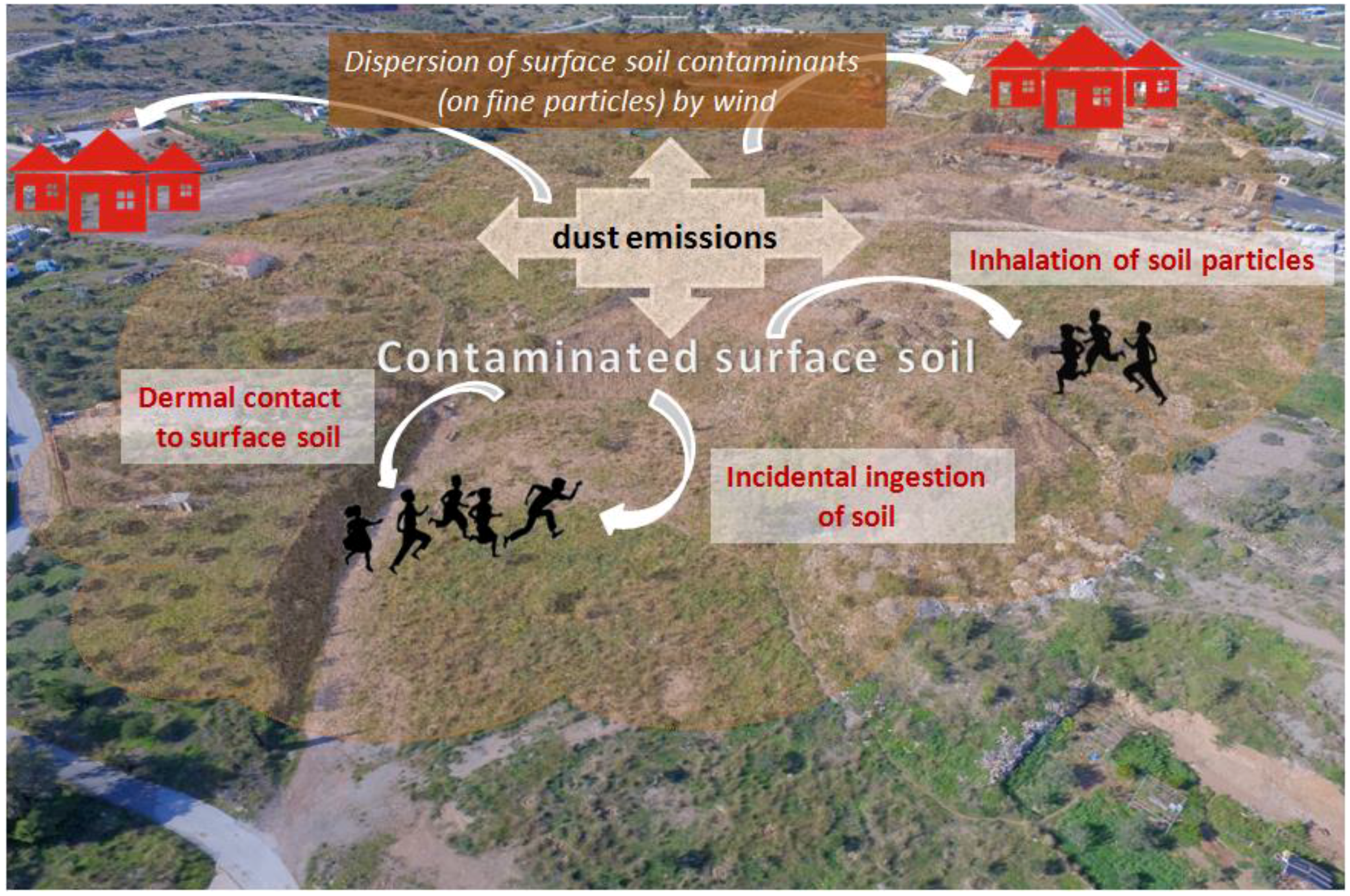
(b) Exposure Assessment: The exposure assessment focuses on estimating a substance dose (chronic daily intake in mg/kg-day) to which individuals are exposed or are about to be exposed. The pollutant linkage is evaluated, in terms of the pathways, the routes of exposure, frequency, and duration of exposure and the susceptible population, based on the current and future land use scenario.
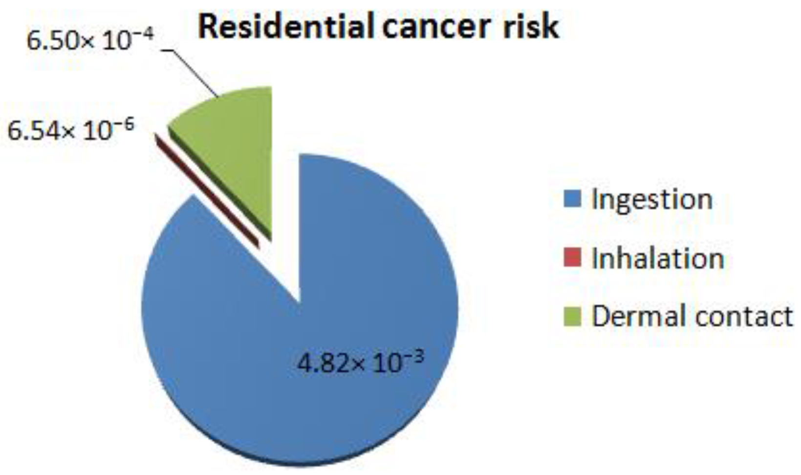
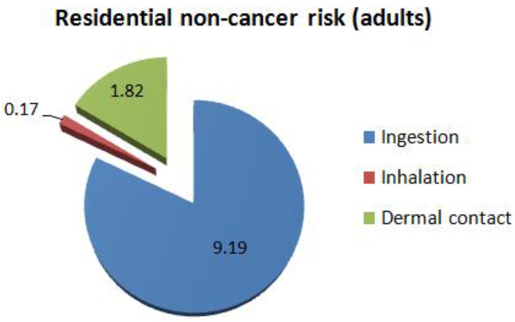
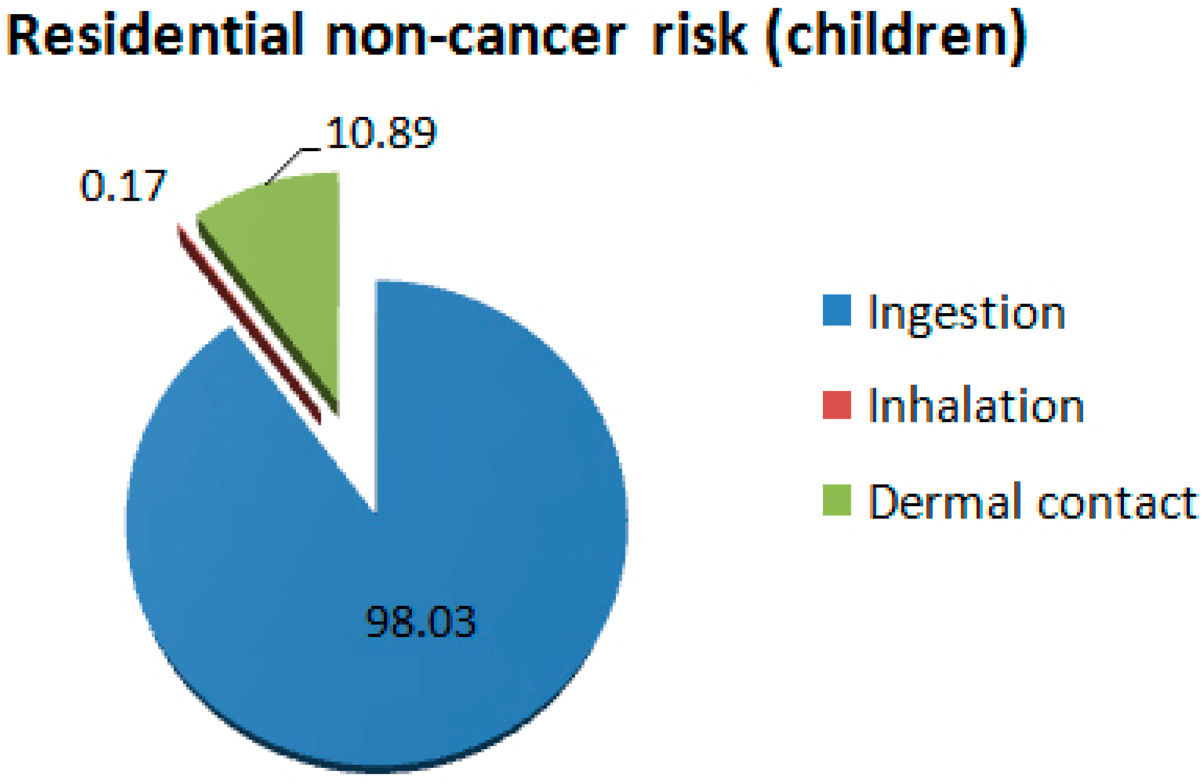
The Kavodokanos site consists mainly of open space land and a couple of dwellings and is located in close proximity to a residential area. It is intended to be used as a recreational site, therefore cancer and non-cancer risks are estimated both for visitors (recreationists) and residents. Non-cancer risks are estimated for children and adults separately. Three routes of exposure are examined: inhalation of soil particles, dermal contact, and oral intake (ingestion).
Default exposure parameters that represent Reasonable Maximum Exposure conditions for long-term exposure are mostly used in the analysis. These parameters are based on EPA’s Risk Assessment Guidance for Superfund [
23] and Soil Screening Guidance documents [
24,
25]. Human health risk to recreationists was estimated assuming 75 visits per year (Exposure frequency EF = 75 days/year), which is a conservative assumption, representing reasonable maximum exposure (RME) recommended by EPA [
22]. It is considered both protective and reasonable since the site is always open to visitors and trespassers (there is no supervision or barriers such as fences) and in close proximity to the city of Lavrion. Since there is an amount of uncertainty in exposure frequency estimates and for comparison reasons, human health risk was also estimated for the unlikely scenario of a single visit to the site per year.
In order to deal with spatial heterogeneity in soil contamination and uncertainty in calculating the average concentration at the site, the 95% upper confidence limit (UCL) of the mean is calculated for each contaminant of concern, by means of the ProUCL software (
Table 4). The 95% UCL of the mean is recommended as a conservative estimate of the concentration likely to be contacted over time [
26,
27,
28].
The following general equation is used to estimate the exposure dose resulting from contact with each contaminant in soil:
where:
CDI: dose-chemical intake (mg/kg-day);
C: concentration of a substance in an environmental medium (mg/unit);
CR: contact rate (units/day);
EF: exposure frequency (days/year);
ED: exposure duration (years);
BW: body weight (Kg);
AT: average time (years).
(c) Toxicity Assessment: Toxicity assessment refers to dose-response evaluation. Toxicity values are used to describe the cancer and non-cancer health effects caused by differing levels of exposure (or doses) to a specific contaminant. Reference Dose (oral) and Reference Concentration (inhalation) refer to non-carcinogenic health effects, while Slope Factor (oral) and Unit Risk Factor (inhalation) refer to carcinogenic risk. Oral slope factor (SF) is an estimate of the increased cancer risk from oral exposure to a dose of 1 mg/kg-day for a lifetime. The SF can be multiplied by an estimate of lifetime exposure (in mg/kg-day) to estimate the lifetime cancer risk (IRIS). Inhalation unit risk (URF) is an estimate of the increased cancer risk from inhalation exposure to a concentration of 1 μg/m
3 for a lifetime. The IUR can be multiplied by an estimate of lifetime exposure (in μg/m
3) to estimate the lifetime cancer risk. Oral reference dose (RfD) is the amount of a chemical that one can ingest every day for a lifetime (mg/kg-day), that is not anticipated to cause harmful non-cancer health effects. Inhalation reference concentration (RfC) is the concentration of a chemical that one can breathe every day for a lifetime that is not anticipated to cause harmful non-cancer health effects. The RfC can be compared to an estimate of exposure concentration in mg/m
3. Toxicity values, for use in EPA-recommended human health risk assessments, are available from several sources. The recommended hierarchy for these alternative sources is described in Human Health Toxicity Values in Superfund Risk Assessments [
29]: The preferred source of toxicity data is EPA’s Integrated Risk Information System (IRIS) database [
30]. Values in this database have been derived by expert toxicologists at EPA and most values have undergone thorough review and validation both within and outside EPA. If toxicity values for a contaminant of potential concern are not available in IRIS, the next source to consult is EPA’s Provisional Peer Reviewed Toxicity Values (PPRTVs). This source includes toxicity values that have been developed by the Office of Research and Development/National Center for Environmental Assessment/Superfund Health Risk Technical Support Center (STSC) [
31]. Other Toxicity Values may be used, such as the California EPA (Cal/EPA)’s Toxicity Criteria Database Exit, the Agency for Toxic Substances and Disease Registry (ATSDR)’s Minimal Risk Levels (MRLs) for Hazardous Substances [
32] and the toxicity values in EPA’s Health Effects Assessment Summary Tables (HEAST) [
33].
The toxicity parameters for chronic exposure and their relative sources that were used in our analysis are presented in
Table 5.
(d) Risk Characterization: The final step of the risk assessment process is to quantify the potential for carcinogenic and non-carcinogenic impacts for all possible routes of exposure. U.S. EPA has established an acceptable hazard quotient (HQ) equal to 1, for non-carcinogenic effects, while the acceptable cancer risk, expressing the probability of an individual developing any type of cancer if exposed to carcinogenic agents during his or her lifetime, equals 1.0 × 10
−6. Hazard quotients and cancer risks for each contaminant and route of exposure are calculated using Equations (2)–(7) based on EPA’s Risk Assessment Guidance for Superfund: Volume I, Parts A, E & F [
21,
34,
35].
- (i)
For carcinogenic effects due to soil ingestion:
- (ii)
For non-carcinogenic effects due to soil ingestion:
- (iii)
For carcinogenic effects due to inhalation of particulates:
- (iv)
For non-carcinogenic risks due to inhalation of particulates:
- (v)
For carcinogenic effects due to dermal contact:
- (vi)
For non-carcinogenic effects due to dermal contact:
where: GIABS stands for GastroIntestinal ABSorption factor. The GIABS value is used to convert oral slope factors (administered dose) to dermal slope factors (administered dose) by factoring out the percentage eliminated in bodily waste.
In order to quantify non-carcinogenic risk for multiple substances, an additive approach is used. In particular, the Hazard Index (HI) is defined as the sum of all Hazard Quotients:
where: HQi is the Hazard Quotient attributable to a single substance.
The same approach is followed for carcinogenic effects involving more than one chemical:
where: Rt the total risk and Ri is the risk derived from the presence of a single substance.
Total risk is calculated by summation of all risks for each route of exposure, for cancer and non-cancer health effects, respectively.
5. Discussion and Conclusions
Contaminated mined land is a problem that deserves emergency attention due to its magnitude and impacts on human health and the environment. Existing soil conservation policies and legislation are based almost solely on limit values for certain contaminants, which can be achieved only by means of soil remediation techniques. Nevertheless, soil remediation is not always possible due to the prohibitive costs incurred. In such cases, risk-based approaches may be a much more useful decision-making tool.
For instance, in the case studied, the results of risk assessment analysis showed that immediate measures have to be taken in order to protect human health, either by source elimination or by pathway management (e.g., by using a barrier to prevent exposure to contaminants). To meet international standards for site remediation by eliminating the source of the hazard via typical remediation techniques would require a cost 4–6 million Euros, according to
Table 1. Provided that: (a) available funds are insufficient to permit treatment of all contaminated soil; (b) the site is already being used as recreational open space and, in addition, the surrounding area has a residential character; and (c) source elimination would eliminate not only the risks but also the opportunities to create value in the future by re-using the mine waste, then the remediation plan should be suitable for breaking the link between the routes of exposure and the susceptible population. To this end, it proposes the construction of an upper sealing layer, the installation of the drainage system and the placement of the topsoil since, according to the geological structure, leakages were expected from the substratum.
Although risk assessment estimates are subject to uncertainty, the risk-based approach provided a formal basis to evaluate and rank potential hazards with respect to a branch of factors (e.g., economic, social, political). Moreover, it highlighted and prioritized local conditions and needs, and directed the proposed solution towards the most suitable site- and time-specific actions so as to make the site safe for its users, until technological advancements and economic developments make the recovery of stored materials feasible. Finally, risk assessment assimilates different kinds of technical and non-technical information, helps all parties involved (e.g., competent authorities, site managers, and the public) understand the true dimensions of the problem, and thus minimizes any delays in the remediation actions required.


