Estimation and Validation of RapidEye-Based Time-Series of Leaf Area Index for Winter Wheat in the Rur Catchment (Germany)

 , and
, and
Abstract
1. Introduction
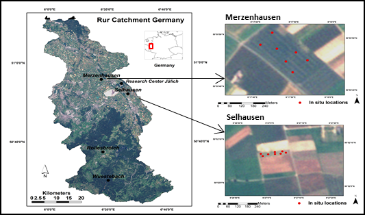
2. Study Area
3. RapidEye and In Situ Measurements
3.1. RapidEye Data
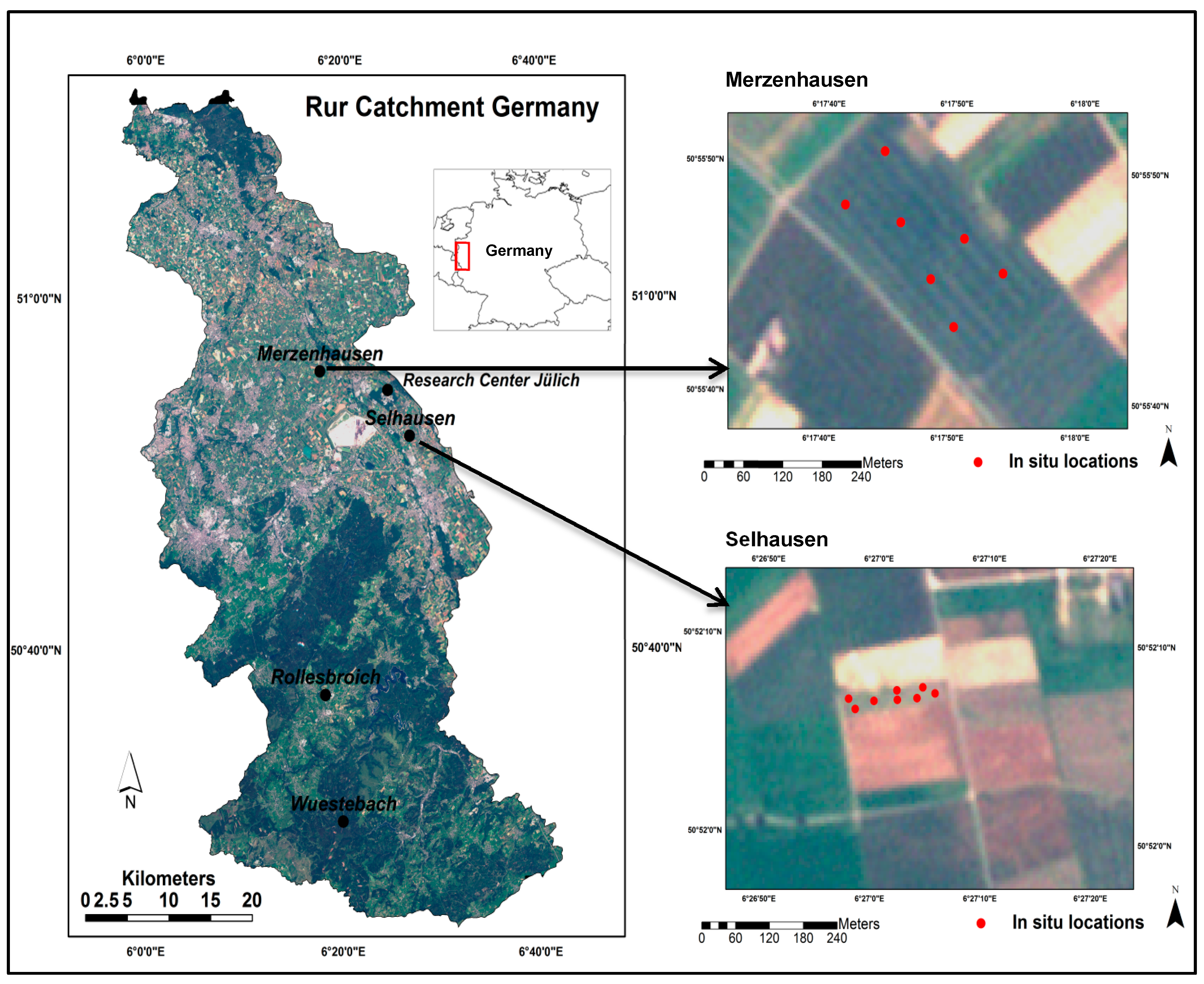
3.2. In Situ LAI Measurements (LAIdestr)

| Selhausen | Merzenhausen | ||||
|---|---|---|---|---|---|
| RapidEye | RapidEye Acquisition Time (UTC) | Destructive LAI | RapidEye | RapidEye Acquisition Time (UTC) | Destructive LAI |
| 2011 | 2011 | ||||
| 07 April | 11:42:30 | 07 April | 02 April | 11:37:42 | 29 March |
| 24 April | 11:42:04 | 18 April | 07 April | 11:42:27 | 15 April |
| 10 May | 11:34:49 | 03 May | 02 May | 11:28:02 | 04 May |
| 21 May | 11:44:59 | 18 May | 21 May | 11:44:56 | 23 May |
| 30 May | 11:34:32 | 03 June | 01 June | 11:39:51 | 11 June |
| 27 June | 11:43:00 | 27 June | 27 June | 11:42:57 | 20 June |
| 01 September | 11:28:44 | 30 August | |||
| 2012 | |||||
| 03 April | 11:39:35 | 30 March | |||
| 25 May | 11:30:21 | 25 May | |||
| 08 June | 11:47:27 | 12 June | |||
| 26 July | 11:32:19 | 24 July | |||
4. Approach/Methods
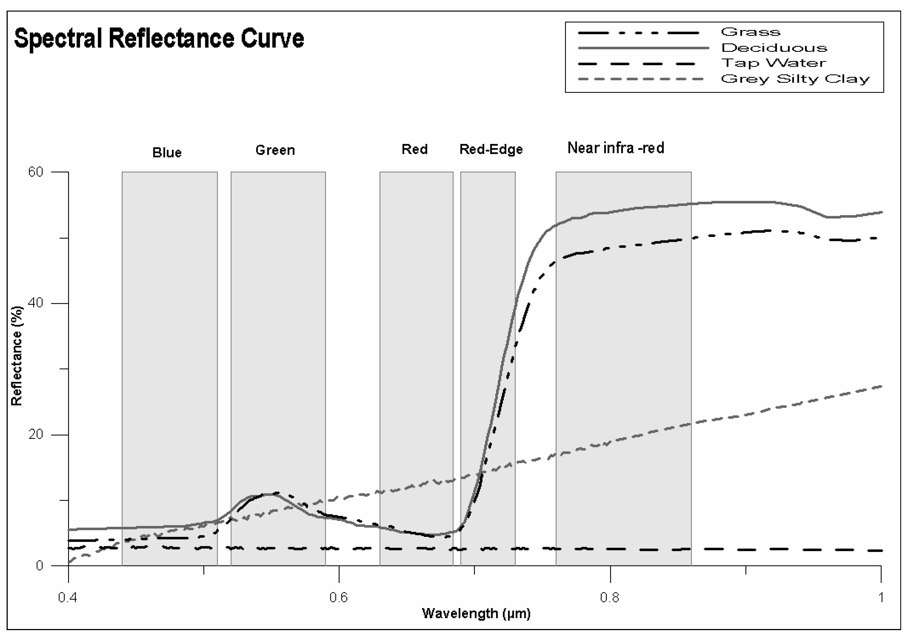
4.1. The Need for Radiometric/Atmospheric Correction

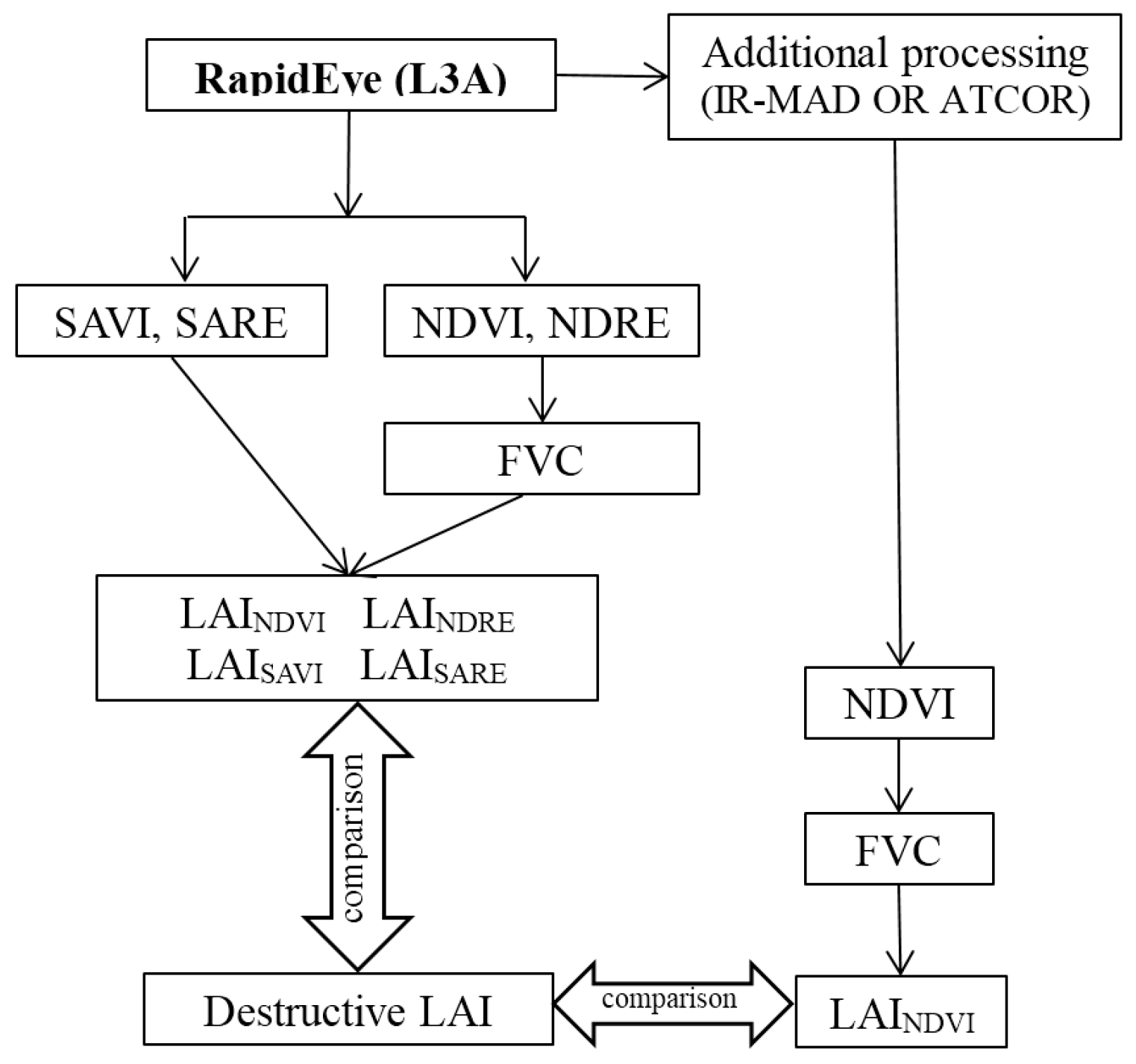
4.2. Estimation of LAI Time-Series from RapidEye
4.3. Impact of the Soil Contribution on LAI Calculation
4.4. Role of the Red-Edge Band
5. Results and Discussion
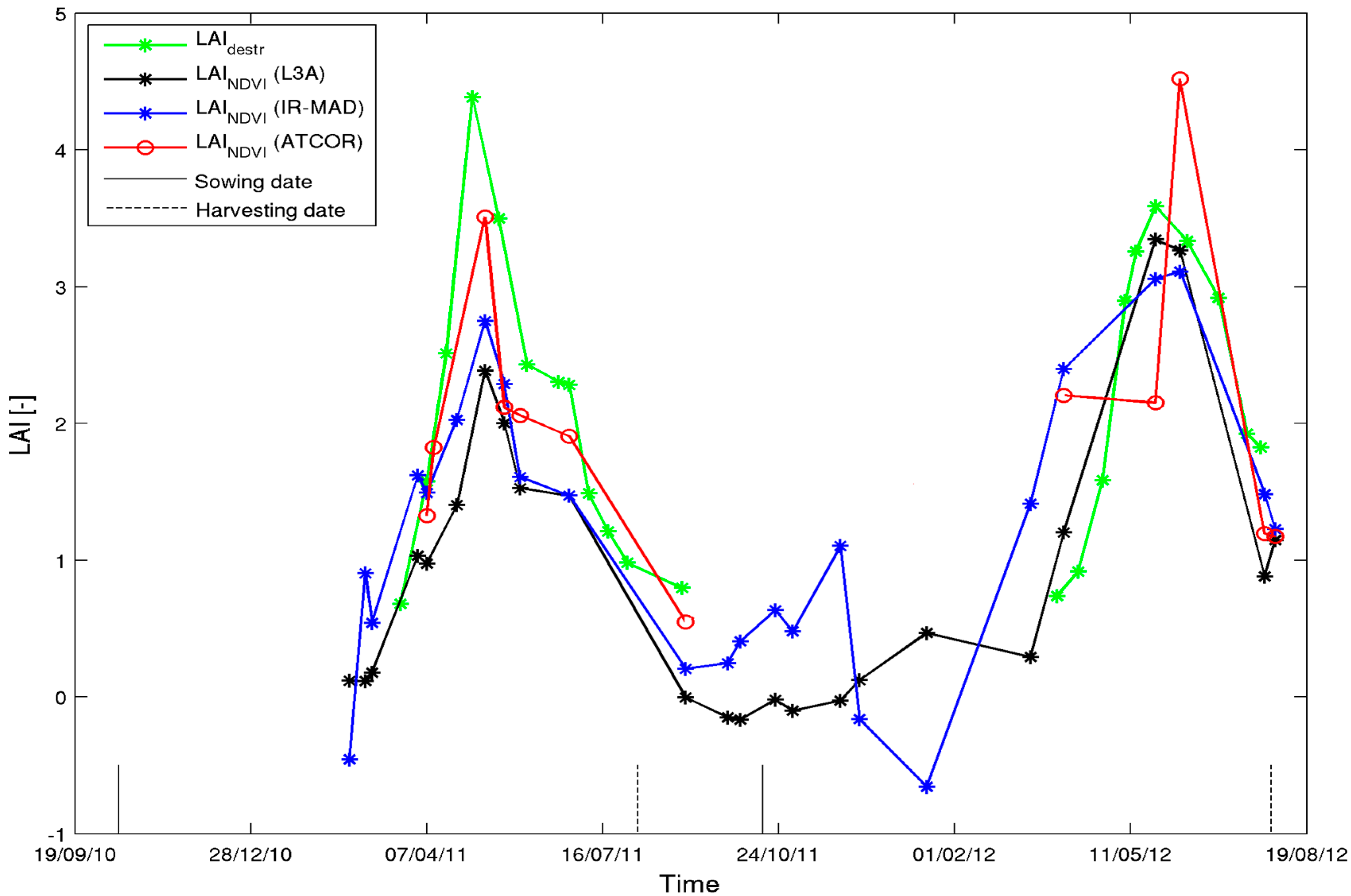
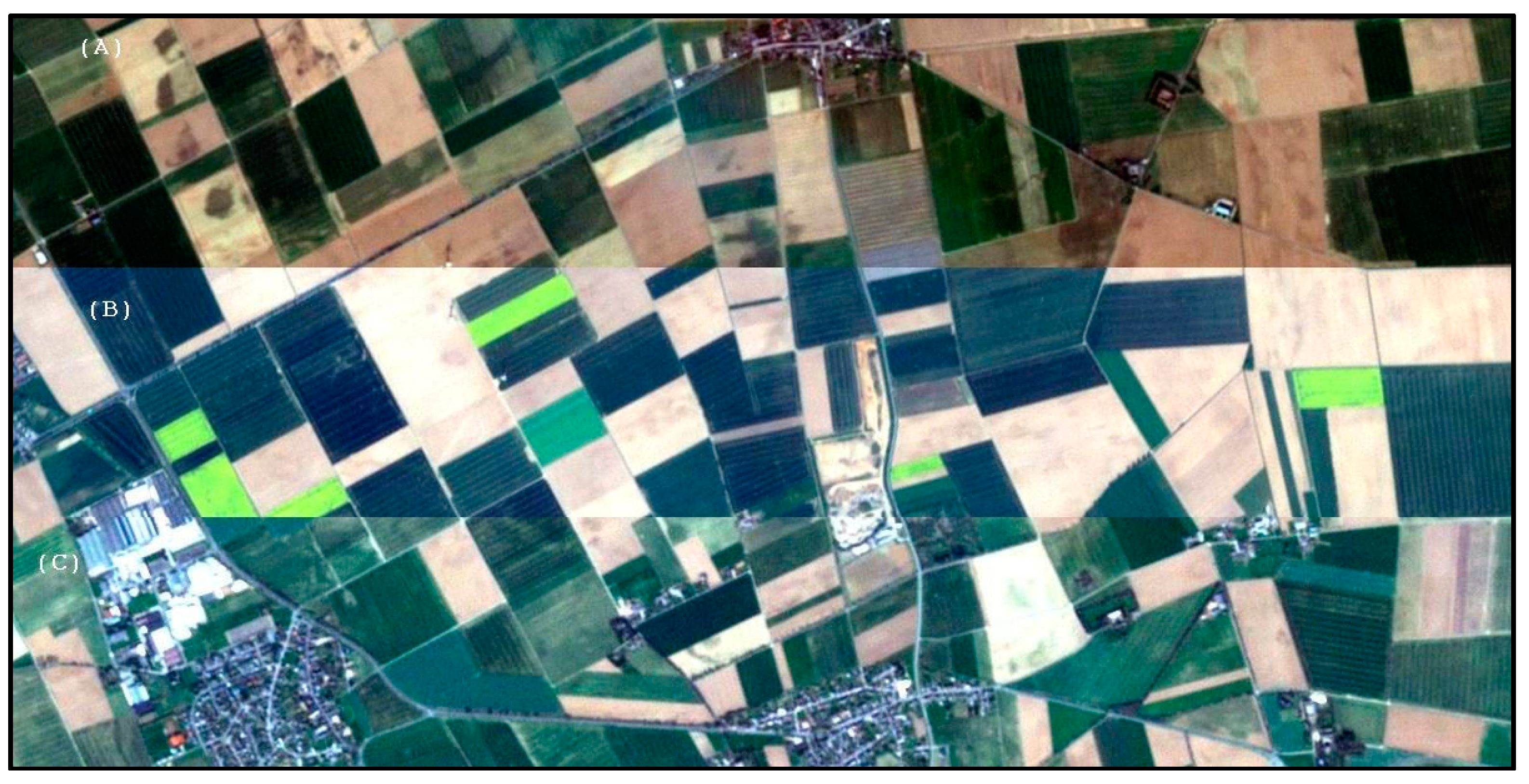
5.1. Impact of the Absolute and Relative Atmospheric/Radiometric Correction
| Spectral Vegetation Index | Atmospheric Correction Methods | ||
|---|---|---|---|
| L3A | IR-MAD | ATCOR | |
| NDVI | 0.85 (0.0005) 0.85 (0.033) | 0.72 (0.0077) 0.77 (0.075) | 0.60 (0.040) 0.90 (0.012) |
| NDRE | 0.90 (0.0001) 0.92 (0.009) | 0.70 (0.0104) 0.83 (0.040) | 0.68 (0.014) 0.92 (0.007) |
| SAVI | 0.85 (0.0005) 0.85 (0.033) | 0.72 (0.0081) 0.77 (0.075) | 0.60 (0.040) 0.90 (0.012) |
| SARE | 0.90 (0.0001) 0.92 (0.009) | 0.70 (0.0121) 0.83 (0.040) | 0.68 (0.014) 0.92 (0.007) |
| LAIrapideye vs. LAIdestr for Winter Wheat | Selhausen (2011–2012) | Merzenhausen (2011) | ||||
|---|---|---|---|---|---|---|
| r | p-value | RMSD | r | p-value | RMSD | |
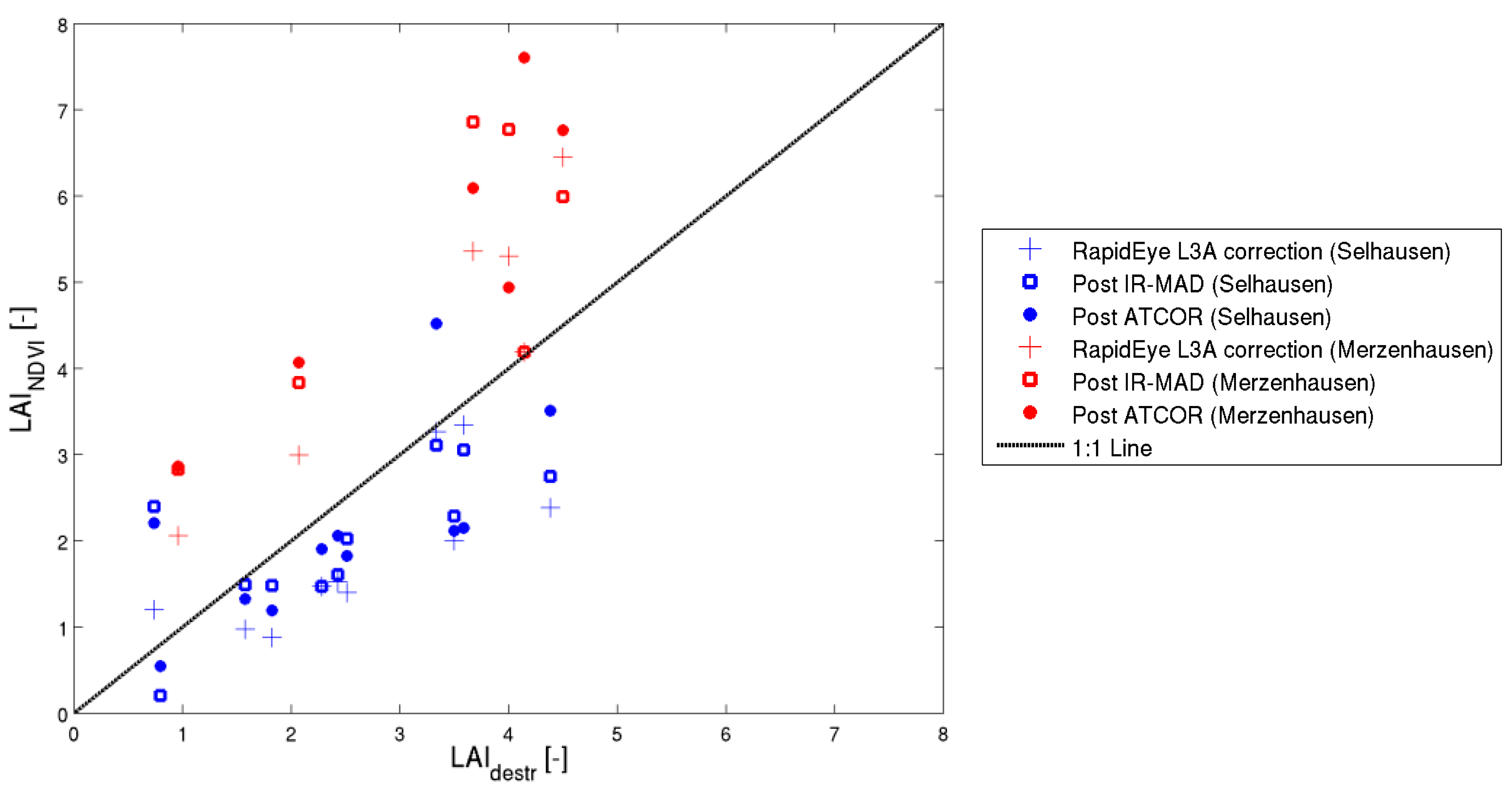
| LAINDVI (L3A) (k(θ) = 0.25) | 0.82 | 0.0010 | 0.99 | 0.78 | 0.05 | 1.09 |
| LAINDVI (IR-MAD) (k(θ) = 0.25) | 0.71 | 0.0093 | 0.89 | 0.68 | 0.138 | 1.70 |
| LAINDVI (ATCOR) (k(θ) = 0.25) | 0.68 | 0.014 | 0.91 | 0.89 | 0.016 | 2.30 |

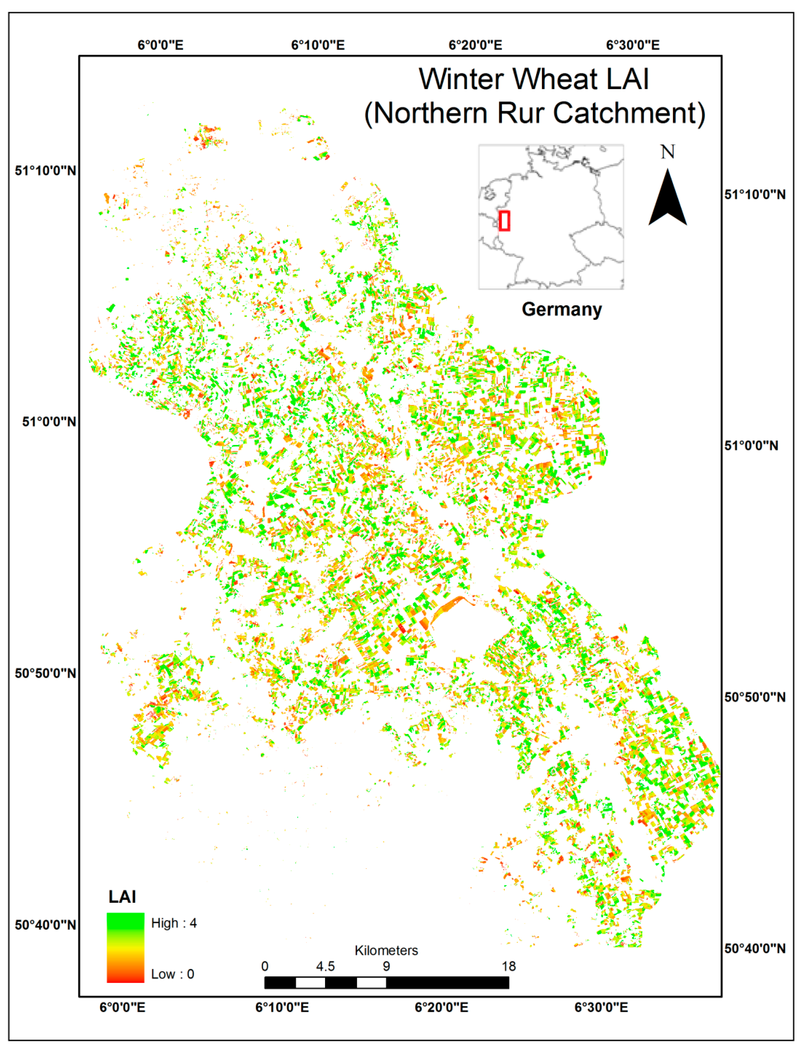
5.2. Estimation of LAI Time-Series from RapidEye
| LAIrapideye vs. LAIdestr for Winter Wheat | Selhausen (2011–2012) | Merzenhausen (2011) | ||||
|---|---|---|---|---|---|---|
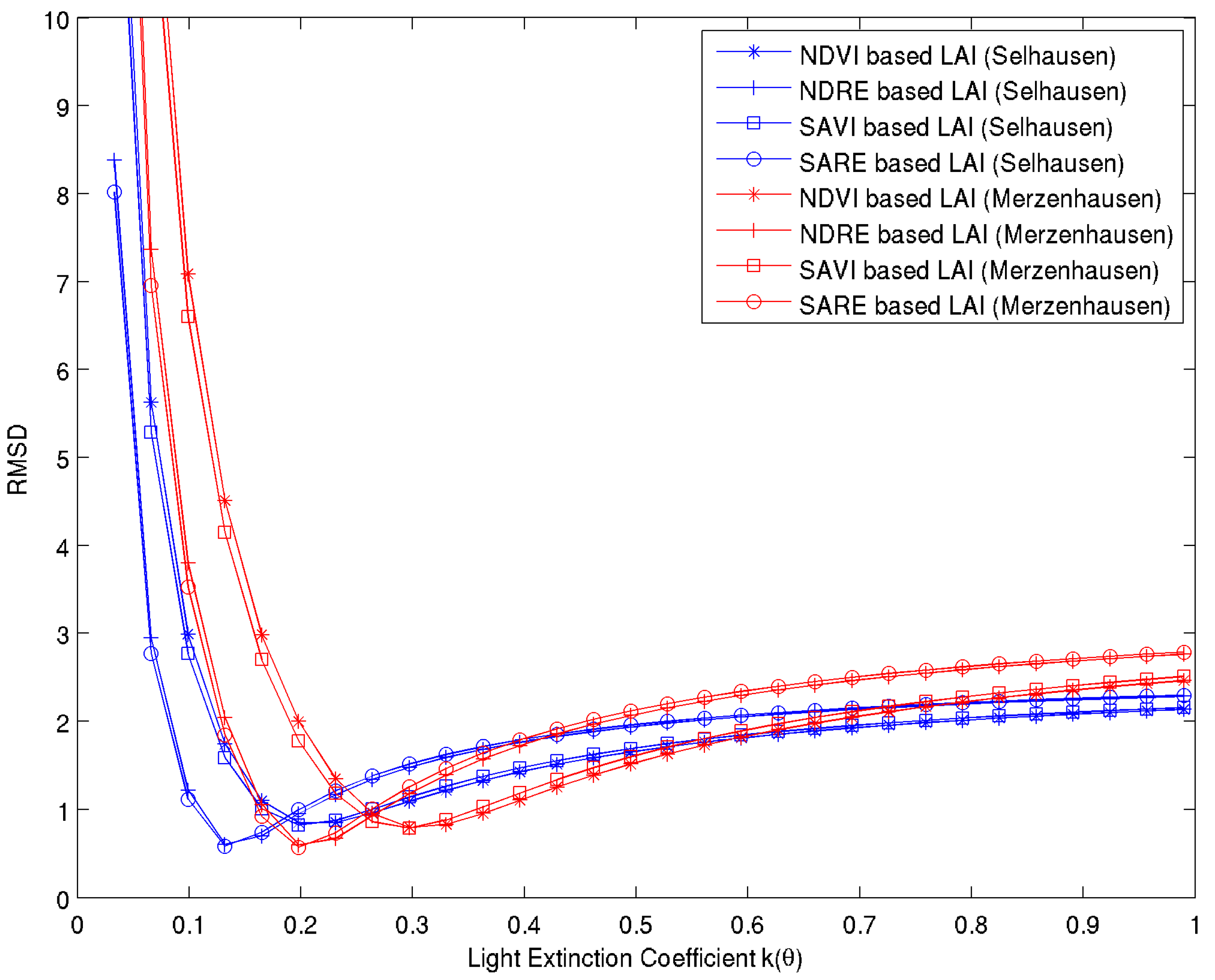
| k(θ) | r | RMSD | k(θ) | r | RMSD | |
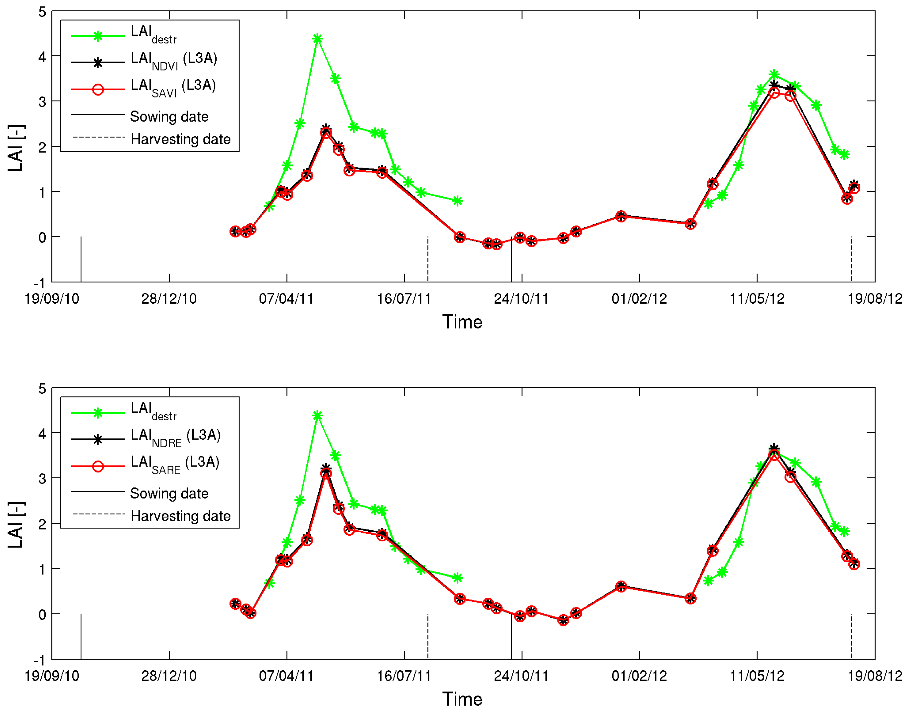
| LAINDVI | 0.19 | 0.81 | 1.05 | 0.36 | 0.84 | 0.91 |
| LAINDRE | 0.12 | 0.88 | 1.01 | 0.22 | 0.84 | 0.86 |
| LAISAVI | 0.19 | 0.81 | 0.96 | 0.34 | 0.84 | 0.89 |
| LAISARE | 0.12 | 0.88 | 0.92 | 0.21 | 0.85 | 0.84 |

6. Conclusions and Outlook
Acknowledgments
Author Contributions
Conflicts of Interest
References
- Mu, Q.Z.; Zhao, M.S.; Running, S.W. Evolution of hydrological and carbon cycles under a changing climate. Part iii: Global change impacts on landscape scale evapotranspiration. Hydrol. Process. 2011, 25, 4093–4102. [Google Scholar] [CrossRef]
- Weiss, J.L.; Gutzler, D.S.; Coonrod, J.E.A.; Dahm, C.N. Seasonal and inter-annual relationships between vegetation and climate in central new Mexico, USA. J. Arid. Environ. 2004, 57, 507–534. [Google Scholar] [CrossRef]
- Arora, V. Modeling vegetation as a dynamic component in soil-vegetation-atmosphere transfer schemes and hydrological models. Rev. Geophys. 2002, 40. [Google Scholar] [CrossRef]
- Sellers, P.J.; Dickinson, R.E.; Randall, D.A.; Betts, A.K.; Hall, F.G.; Berry, J.A.; Collatz, G.J.; Denning, A.S.; Mooney, H.A.; Nobre, C.A.; et al. Modeling the exchanges of energy, water, and carbon between continents and the atmosphere. Science 1997, 275, 502–509. [Google Scholar] [CrossRef] [PubMed]
- Ge, J.J. On the proper use of satellite-derived leaf area index in climate modeling. J. Clim. 2009, 22, 4427–4433. [Google Scholar] [CrossRef]
- Atzberger, C. Advances in remote sensing of agriculture: Context description, existing operational monitoring systems and major information needs. Remote Sens. 2013, 5, 949–981. [Google Scholar] [CrossRef]
- Rembold, F.; Atzberger, C.; Savin, I.; Rojas, O. Using low resolution satellite imagery for yield prediction and yield anomaly detection. Remote Sens. 2013, 5, 1704–1733. [Google Scholar] [CrossRef]
- Jonckheere, I.; Fleck, S.; Nackaerts, K.; Muys, B.; Coppin, P.; Weiss, M.; Baret, F. Review of methods for in situ leaf area index determination—Part i. Theories, sensors and hemispherical photography. Agric. For. Meteorol. 2004, 121, 19–35. [Google Scholar] [CrossRef]
- Curran, P.J. Multispectral remote-sensing for the estimation of green leaf-area index. Philos. Trans. R. Soc. A Math. Phys. Eng. Sci. 1983, 309, 257–270. [Google Scholar] [CrossRef]
- Verhoef, W. Light-scattering by leaf layers with application to canopy reflectance modeling—The sail model. Remote Sens. Environ. 1984, 16, 125–141. [Google Scholar] [CrossRef]
- Jacquemoud, S.; Verhoef, W.; Baret, F.; Bacour, C.; Zarco-Tejada, P.J.; Asner, G.P.; Francois, C.; Ustin, S.L. Prospect plus sail models: A review of use for vegetation characterization. Remote Sens. Environ. 2009, 113, S56–S66. [Google Scholar] [CrossRef]
- Haboudane, D.; Miller, J.R.; Pattey, E.; Zarco-Tejada, P.J.; Strachan, I.B. Hyperspectral vegetation indices and novel algorithms for predicting green lai of crop canopies: Modeling and validation in the context of precision agriculture. Remote Sens. Environ. 2004, 90, 337–352. [Google Scholar] [CrossRef]
- Clevers, J.G.P.W. Application of remote sensing to agricultural field trials. Wagening. Agric. Univ. Pap. 1986, 86, 1–227. [Google Scholar]
- Clevers, J. The derivation of a simplified reflectance model for the estimation of leaf-area index. Remote Sens. Environ. 1988, 25, 53–69. [Google Scholar] [CrossRef]
- Clevers, J. The application of a weighted infrared-red vegetation index for estimating leaf-area index by correcting for soil-moisture. Remote Sens. Environ. 1989, 29, 25–37. [Google Scholar] [CrossRef]
- Colombo, R.; Bellingeri, D.; Fasolini, D.; Marino, C.M. Retrieval of leaf area index in different vegetation types using high resolution satellite data. Remote Sens. Environ. 2003, 86, 120–131. [Google Scholar] [CrossRef]
- Walthall, C.; Dulaney, W.; Anderson, M.; Norman, J.; Fang, H.L.; Liang, S.L. A comparison of empirical and neural network approaches for estimating corn and soybean leaf area index from Landsat ETM+ imagery. Remote Sens. Environ. 2004, 92, 465–474. [Google Scholar] [CrossRef]
- Cohen, W.B.; Maiersperger, T.K.; Gower, S.T.; Turner, D.P. An improved strategy for regression of biophysical variables and Landsat ETM+ data. Remote Sens. Environ. 2003, 84, 561–571. [Google Scholar] [CrossRef]
- Atzberger, C.; Guerif, M.; Baret, F.; Werner, W. Comparative analysis of three chemometric techniques for the spectroradiometric assessment of canopy chlorophyll content in winter wheat. Comput. Electron. Agric. 2010, 73, 165–173. [Google Scholar] [CrossRef]
- Mirzaie, M.; Darvishzadeh, R.; Shakiba, A.; Matkan, A.A.; Atzberger, C.; Skidmore, A. Comparative analysis of different uni- and multi-variate methods for estimation of vegetation water content using hyper-spectral measurements. Int. J. Appl. Earth Obs. Geoinf. 2014, 26, 1–11. [Google Scholar] [CrossRef]
- Thorp, K.R.; Batchelor, W.D.; Paz, J.O.; Kaleita, A.L.; DeJonge, K.C. Using cross-validation to evaluate ceres-maize yield simulations within a decision support system for precision agriculture. Trans. ASABE 2007, 50, 1467–1479. [Google Scholar] [CrossRef]
- Deng, F.; Chen, J.M.; Plummer, S.; Chen, M.Z.; Pisek, J. Algorithm for global leaf area index retrieval using satellite imagery. IEEE Trans. Geosci. Remote Sens. 2006, 44, 2219–2229. [Google Scholar] [CrossRef]
- Vuolo, F.; Atzberger, C.; Richter, K.; D’Urso, G.; Dash, J. Retrieval of biophysical vegetation products from rapideye imagery. 100 Years ISPRS Adv. Remote Sens. Sci. Part 1 2010, 38, 281–286. [Google Scholar]
- Asrar, G.; Fuchs, M.; Kanemasu, E.T.; Hatfield, J.L. Estimating absorbed photosynthetic radiation and leaf-area index from spectral reflectance in wheat. Agron. J. 1984, 76, 300–306. [Google Scholar] [CrossRef]
- Baret, F.; Guyot, G. Potentials and limits of vegetation indexes for LAI and APAR assessment. Remote Sens. Environ. 1991, 35, 161–173. [Google Scholar] [CrossRef]
- Rouse, J.W.; Haas, R.H.; Schell, J.A.; Deering, D.W. Monitoring vegetation systems in the great plains with ERTS. In Proceedings of the Third Earth Resources Technology Satellite-1 Symposium, NASA SP-351, Washington, DC, USA, 10–14 December 1973; pp. 309–317.
- Huete, A.R. A soil-adjusted vegetation index (SAVI). Remote Sens. Environ. 1988, 25, 295–309. [Google Scholar] [CrossRef]
- Xie, Y.C.; Sha, Z.Y.; Yu, M. Remote sensing imagery in vegetation mapping: A review. J. Plant Ecol. 2008, 1, 9–23. [Google Scholar] [CrossRef]
- Vereecken, H.; Weihermuller, L.; Jonard, F.; Montzka, C. Characterization of crop canopies and water stress related phenomena using microwave remote sensing methods: A review. Vadose Zone J. 2012, 11. [Google Scholar] [CrossRef]
- Duggin, M.J.; Piwinski, D. Recorded radiance indexes for vegetation monitoring using noaa AVHRR data—Atmospheric and other effects in multitemporal data sets. Appl. Opt. 1984, 23, 2620–2623. [Google Scholar] [CrossRef] [PubMed]
- Gao, F.; Anderson, M.C.; Kustas, W.P.; Wang, Y.J. Simple method for retrieving leaf area index from landsat using MODIS leaf area index products as reference. J. Appl. Remote Sens. 2012, 6. [Google Scholar] [CrossRef]
- Propastin, P.; Panferov, O. Retrieval of remotely sensed LAI using Landsat ETM plus data and ground measurements of solar radiation and vegetation structure: Implication of leaf inclination angle. Int. J. Appl. Earth Obs. Geoinf. 2013, 25, 38–46. [Google Scholar] [CrossRef]
- Barnett, T.L.; Thompson, D.R. Large-area relation of landsat mss and NOAA-6 AVHRR spectral data to wheat yields. Remote Sens. Environ. 1983, 13, 277–290. [Google Scholar] [CrossRef]
- Chen, J.M.; Cihlar, J. Retrieving leaf area index of boreal conifer forests using Landsat TM images. Remote Sens. Environ. 1996, 55, 153–162. [Google Scholar] [CrossRef]
- Turner, D.P.; Cohen, W.B.; Kennedy, R.E.; Fassnacht, K.S.; Briggs, J.M. Relationships between leaf area index and Landsat TM spectral vegetation indices across three temperate zone sites. Remote Sens. Environ. 1999, 70, 52–68. [Google Scholar] [CrossRef]
- Pu, R.L.; Gong, P. Wavelet transform applied to EO-1 hyperspectral data for forest LAI and crown closure mapping. Remote Sens. Environ. 2004, 91, 212–224. [Google Scholar] [CrossRef]
- Schlerf, M.; Atzberger, C. Inversion of a forest reflectance model to estimate structural canopy variables from hyperspectral remote sensing data. Remote Sens. Environ. 2006, 100, 281–294. [Google Scholar] [CrossRef]
- Norman, J.M.; Kustas, W.P.; Humes, K.S. Source approach for estimating soil and vegetation energy fluxes in observations of directional radiometric surface-temperature. Agric. For. Meteorol. 1995, 77, 263–293. [Google Scholar] [CrossRef]
- Sprintsin, M.; Karnieli, A.; Berliner, P.; Rotenberg, E.; Yakir, D.; Cohen, S. The effect of spatial resolution on the accuracy of leaf area index estimation for a forest planted in the desert transition zone. Remote Sens. Environ. 2007, 109, 416–428. [Google Scholar] [CrossRef]
- Propastin, P.; Erasmi, S. A physically based approach to model LAI from MODIS 250 m data in a tropical region. Int. J. Appl. Earth Obs. Geoinf. 2010, 12, 47–59. [Google Scholar] [CrossRef]
- Ullah, S.; Si, Y.; Schlerf, M.; Skidmore, A.K.; Shafique, M.; Iqbal, I.A. Estimation of grassland biomass and nitrogen using MERIS data. Int. J. Appl. Earth Obs. Geoinf. 2012, 19, 196–204. [Google Scholar] [CrossRef]
- Darvishzadeh, R.; Atzberger, C.; Skidmore, A.K.; Abkar, A.A. Leaf area index derivation from hyperspectral vegetation indices and the red edge position. Int. J. Remote Sens. 2009, 30, 6199–6218. [Google Scholar] [CrossRef]
- Ehammer, A.; Fritsch, S.; Conrad, C.; Lamers, J.; Dech, S. Statistical derivation of FPAR and LAI for irrigated cotton and rice in arid uzbekistan by combining multi-temporal Rapideye data and ground measurements. Proc. SPIE 2010, 7824. [Google Scholar] [CrossRef]
- Eitel, J.U.H.; Vierling, L.A.; Litvak, M.E.; Long, D.S.; Schulthess, U.; Ager, A.A.; Krofcheck, D.J.; Stoscheck, L. Broadband, red-edge information from satellites improves early stress detection in a new mexico conifer woodland. Remote Sens. Environ. 2011, 115, 3640–3646. [Google Scholar] [CrossRef]
- Schuster, C.; Forster, M.; Kleinschmit, B. Testing the red edge channel for improving land-use classifications based on high-resolution multi-spectral satellite data. Int. J. Remote Sens. 2012, 33, 5583–5599. [Google Scholar] [CrossRef]
- Filella, I.; Penuelas, J. The red edge position and shape as indicators of plant chloro phyll content, biomass and hydric status. Int. J. Remote Sens. 1994, 15, 1459–1470. [Google Scholar] [CrossRef]
- Eitel, J.U.H.; Long, D.S.; Gessler, P.E.; Smith, A.M.S. Using in-situ measurements to evaluate the new Rapideye (TM) satellite series for prediction of wheat nitrogen status. Int. J. Remote Sens. 2007, 28, 4183–4190. [Google Scholar] [CrossRef]
- Asam, S.; Fabritius, H.; Klein, D.; Conrad, C.; Dech, S. Derivation of leaf area index for grassland within alpine upland using multi-temporal Rapideye data. Int. J. Remote Sens. 2013, 34, 8628–8652. [Google Scholar] [CrossRef]
- Hadjimitsis, D.G.; Papadavid, G.; Agapiou, A.; Themistocleous, K.; Hadjimitsis, M.G.; Retalis, A.; Michaelides, S.; Chrysoulakis, N.; Toulios, L.; Clayton, C.R.I. Atmospheric correction for satellite remotely sensed data intended for agricultural applications: Impact on vegetation indices. Nat. Hazards Earth Syst. Sci. 2010, 10, 89–95. [Google Scholar] [CrossRef]
- Yang, X.J.; Lo, C.P. Relative radiometric normalization performance for change detection from multi-date satellite images. Photogramm. Eng. Remote Sens. 2000, 66, 967–980. [Google Scholar]
- Hall, F.G. Radiometric rectification: Toward a common radiometric response among multidate, multisensor imageses. Remote Sens. Environ. 1991, 35, 11–27. [Google Scholar] [CrossRef]
- Montzka, C.; Canty, M.; Kunkel, R.; Menz, G.; Vereecken, H.; Wendland, F. Modelling the water balance of a mesoscale catchment basin using remotely sensed land cover data. J. Hydrol. 2008, 353, 322–334. [Google Scholar] [CrossRef]
- Montzka, C.; Canty, M.; Kreins, P.; Kunkel, R.; Menz, G.; Vereecken, H.; Wendland, F. Multispectral remotely sensed data in modelling the annual variability of nitrate concentrations in the leachate. Environ. Modell. Softw. 2008, 23, 1070–1081. [Google Scholar] [CrossRef]
- TERRESTRIAL ENVIRONMENTAL OBSERVATORIES (TERENO). Available online: http://teodoor.icg.kfa-juelich.de/overview-en (accessed on 5 March 2015).
- Zacharias, S.; Bogena, H.; Samaniego, L.; Mauder, M.; Fuss, R.; Putz, T.; Frenzel, M.; Schwank, M.; Baessler, C.; Butterbach-Bahl, K.; et al. A network of terrestrial environmental observatories in germany. Vadose Zone J. 2011, 10, 955–973. [Google Scholar] [CrossRef]
- Montzka, C.; Bogena, H.R.; Weihermuller, L.; Jonard, F.; Bouzinac, C.; Kainulainen, J.; Balling, J.E.; Loew, A.; Dall’Amico, J.T.; Rouhe, E.; et al. Brightness temperature and soil moisture validation at different scales during the SMOS validation campaign in the RUR and ERFT catchments, Germany. IEEE Trans. Geosci. Remote Sens. 2013, 51, 1728–1743. [Google Scholar] [CrossRef]
- Bogena, H.; Kunkel, R.; Schobel, T.; Schrey, H.P.; Wendland, E. Distributed modeling of groundwater recharge at the macroscale. Ecol. Model. 2005, 187, 15–26. [Google Scholar] [CrossRef]
- Rötzer, K.; Montzka, C.; Bogena, H.; Wegner, W.; Kerr, Y.H.; Kidd, R.; Vereecken, H. Catchment scale validation of SMOS and ASCAT soil moisture products using hydrological modeling and temporal stability analysis. J. Hydrol. 2014, 519, 934–946. [Google Scholar] [CrossRef]
- Rudolph, S.; van der Kruk, J.; von Hebel, C.; Ali, M.; Herbst, M.; Montzka, C.; Pätzold, S.; Robinson, D.A.; Vereecken, H.; Weihermüller, L. Linking satellite derived lai patterns with subsoil heterogeneity using large-scale ground-based electromagnetic induction measurements. Geoderma 2015, 241–242, 262–271. [Google Scholar] [CrossRef]
- Weihermuller, L.; Huisman, J.A.; Lambot, S.; Herbst, M.; Vereecken, H. Mapping the spatial variation of soil water content at the field scale with different ground penetrating radar techniques. J. Hydrol. 2007, 340, 205–216. [Google Scholar] [CrossRef]
- Weihermueller, L. Comparison of Different Soil Water Extraction Systems for the Prognoses of Solute Transport at the Field Scale Using Numerical Simulations, Field and Lysimeter Experiments. Available online: http://hss.ulb.uni-bonn.de/2005/0573/0573-engl.htm (accessed on 9 March 2015).
- BlackBridge-RapidEye. Satellite Imagery Product Specifications. 2013. Available online: http://www.blackbridge.com/rapideye/upload/RE_Product_Specifications_ENG.pdf (accessed on 5 March 2015).
- Breda, N.J.J. Ground-based measurements of leaf area index: A review of methods, instruments and current controversies. J. Exp. Bot. 2003, 54, 2403–2417. [Google Scholar] [CrossRef] [PubMed]
- Stadler, A.; Rudolph, S.; Kupisch, M.; Langensiepen, M.; van der Kruk, J.; Ewert, F. Quantifying the effects of soil variability on crop growth using apparent soil electrical conductivity measurements. Europ. J. Agron. 2015, 64, 8–20. [Google Scholar] [CrossRef]
- Canty, M.J.; Nielsen, A.A. Automatic radiometric normalization of multitemporal satellite imagery with the iteratively re-weighted mad transformation. Remote Sens. Environ. 2008, 112, 1025–1036. [Google Scholar] [CrossRef]
- Canty, M.J.; Nielsen, A.A.; Schmidt, M. Automatic radiometric normalization of multitemporal satellite imagery. Remote Sens. Environ. 2004, 91, 441–451. [Google Scholar] [CrossRef]
- Richter, R. Atmospheric correction of satellite data with haze removal including a haze/clear transition region. Comput. Geosci. 1996, 22, 675–681. [Google Scholar] [CrossRef]
- Richter, R. A spatially adaptive fast atmospheric correction algorithm. Int. J. Remote Sens. 1996, 17, 1201–1214. [Google Scholar] [CrossRef]
- Geerken, R.; Zaitchik, B.; Evans, J.P. Classifying rangeland vegetation type and coverage from ndvi time series using fourier filtered cycle similarity. Int. J. Remote Sens. 2005, 26, 5535–5554. [Google Scholar] [CrossRef]
- Beck, P.S.A.; Atzberger, C.; Hogda, K.A.; Johansen, B.; Skidmore, A.K. Improved monitoring of vegetation dynamics at very high latitudes: A new method using MODIS NDVI. Remote Sens. Environ. 2006, 100, 321–334. [Google Scholar] [CrossRef]
- Zeng, X.B.; Rao, P.; DeFries, R.S.; Hansen, M.C. Interannual variability and decadal trend of global fractional vegetation cover from 1982 to 2000. J. Appl. Meteorol. 2003, 42, 1525–1530. [Google Scholar] [CrossRef]
- Zeng, X.B.; Dickinson, R.E.; Walker, A.; Shaikh, M.; DeFries, R.S.; Qi, J.G. Derivation and evaluation of global 1-km fractional vegetation cover data for land modeling. J. Appl. Meteorol. 2000, 39, 826–839. [Google Scholar] [CrossRef]
- Xiao, J.F.; Moody, A. A comparison of methods for estimating fractional green vegetation cover within a desert-to-upland transition zone in central new mexico, USA. Remote Sens. Environ. 2005, 98, 237–250. [Google Scholar] [CrossRef]
- Norman, J.M.; Kustas, W.P.; Humes, K.S. Source approach for estimating soil and vegetation energy fluxes in observations of directional radiometric surface temperature (vol 77, pg 263, 1995). Agric. For. Meteorol. 1996, 80, 297–297. [Google Scholar] [CrossRef]
- Sims, D.A.; Gamon, J.A. Relationships between leaf pigment content and spectral reflectance across a wide range of species, leaf structures and developmental stages. Remote Sens. Environ. 2002, 81, 337–354. [Google Scholar] [CrossRef]
- Gitelson, A.; Merzlyak, M.N. Spectral reflectance changes associated with autumn senescence of aesculus-hippocastanum l and acer-platanoides l leaves—Spectral features and relation to chlorophyll estimation. J. Plant Physiol. 1994, 143, 286–292. [Google Scholar] [CrossRef]
- Gitelson, A.; Merzlyak, M.N. Quantitative estimation of chlorophyll-a using reflectance spectra—Experiments with autumn chestnut and maple leaves. J. Photochem. Photobiol. B Biol. 1994, 22, 247–252. [Google Scholar] [CrossRef]
- Gu, Z.J.; Shi, X.Z.; Li, L.; Yu, D.S.; Liu, L.S.; Zhang, W.T. Using multiple radiometric correction images to estimate leaf area index. Int. J. Remote Sens. 2011, 32, 9441–9454. [Google Scholar] [CrossRef]
- Abdou, W.A.; Pilorz, S.H.; Helmlinger, M.C.; Conel, J.E.; Diner, D.J.; Bruegge, C.J.; Martonchik, J.V.; Gatebe, C.K.; King, M.D.; Hobbs, P.V. Sua pan surface bidirectional reflectance: A case study to evaluate the effect of atmospheric correction on the surface products of the multi-angle imaging spectroradiometer (MISR) during safari 2000. IEEE Trans. Geosci. Remote Sens. 2006, 44, 1699–1706. [Google Scholar] [CrossRef]
- Qi, J.; Marsett, R.C.; Moran, M.S.; Goodrich, D.C.; Heilman, P.; Kerr, Y.H.; Dedieu, G.; Chehbouni, A.; Zhang, X.X. Spatial and temporal dynamics of vegetation in the san pedro river basin area. Agric. For. Meteorol. 2000, 105, 55–68. [Google Scholar] [CrossRef]
- Aubin, I.; Beaudet, M.; Messier, C. Light extinction coefficients specific to the understory vegetation of the southern boreal forest, Quebec. Can. J. For. Res. Rev. Can. Rech. For. 2000, 30, 168–177. [Google Scholar] [CrossRef]
- White, M.A.; Thornton, P.E.; Running, S.W.; Nemani, R.R. Parametrization and sensitivity analysis of the biome-bgc terrestrial ecosystem model: Net primary production controls. Earth Interact. 2000, 4, 1–85. [Google Scholar] [CrossRef]
- Chen, J.M.; Blanken, P.D.; Blank, T.A.; Guilbeault, M.; Chen, S. Radiation regime and canopy architecture in a boreal aspen forest. Agric. For. Meteorol. 1997, 86, 107–125. [Google Scholar] [CrossRef]
- Lussem, U.; Waldhoff, G. Enhanced Land Use Classification of 2011 for the Rur Catchment. Available online: http://www.tr32db.uni-koeln.de/site/index.php (accessed on 9 March 2015).
- Hasan, S.; Montzka, C.; Rudiger, C.; Ali, M.; Bogena, H.R.; Vereecken, H. Soil moisture retrieval from airborne l-band passive microwave using high resolution multispectral data. ISPRS J. Photogramm. Remote Sens. 2014, 91, 59–71. [Google Scholar] [CrossRef]
- Duchemin, B.; Hadria, R.; Erraki, S.; Boulet, G.; Maisongrande, P.; Chehbouni, A.; Escadafal, R.; Ezzahar, J.; Hoedjes, J.C.B.; Kharrou, M.H.; et al. Monitoring wheat phenology and irrigation in central morocco: On the use of relationships between evapotranspiration, crops coefficients, leaf area index and remotely-sensed vegetation indices. Agric. Water Manag. 2006, 79, 1–27. [Google Scholar] [CrossRef]
- Delegido, J.; Verrelst, J.; Alonso, L.; Moreno, J. Evaluation of sentinel-2 red-edge bands for empirical estimation of green LAI and chlorophyll content. Sensors 2011, 11, 7063–7081. [Google Scholar] [CrossRef] [PubMed]
© 2015 by the authors; licensee MDPI, Basel, Switzerland. This article is an open access article distributed under the terms and conditions of the Creative Commons Attribution license (http://creativecommons.org/licenses/by/4.0/).
Share and Cite
Ali, M.; Montzka, C.; Stadler, A.; Menz, G.; Thonfeld, F.; Vereecken, H. Estimation and Validation of RapidEye-Based Time-Series of Leaf Area Index for Winter Wheat in the Rur Catchment (Germany). Remote Sens. 2015, 7, 2808-2831. https://doi.org/10.3390/rs70302808
Ali M, Montzka C, Stadler A, Menz G, Thonfeld F, Vereecken H. Estimation and Validation of RapidEye-Based Time-Series of Leaf Area Index for Winter Wheat in the Rur Catchment (Germany). Remote Sensing. 2015; 7(3):2808-2831. https://doi.org/10.3390/rs70302808
Chicago/Turabian StyleAli, Muhammad, Carsten Montzka, Anja Stadler, Gunter Menz, Frank Thonfeld, and Harry Vereecken. 2015. "Estimation and Validation of RapidEye-Based Time-Series of Leaf Area Index for Winter Wheat in the Rur Catchment (Germany)" Remote Sensing 7, no. 3: 2808-2831. https://doi.org/10.3390/rs70302808
APA StyleAli, M., Montzka, C., Stadler, A., Menz, G., Thonfeld, F., & Vereecken, H. (2015). Estimation and Validation of RapidEye-Based Time-Series of Leaf Area Index for Winter Wheat in the Rur Catchment (Germany). Remote Sensing, 7(3), 2808-2831. https://doi.org/10.3390/rs70302808