

Assessing Plant Diversity in a Dry Tropical Forest: Comparing the Utility of Landsat and Ikonos Satellite Images


Abstract
1. Introduction
2. Study Area
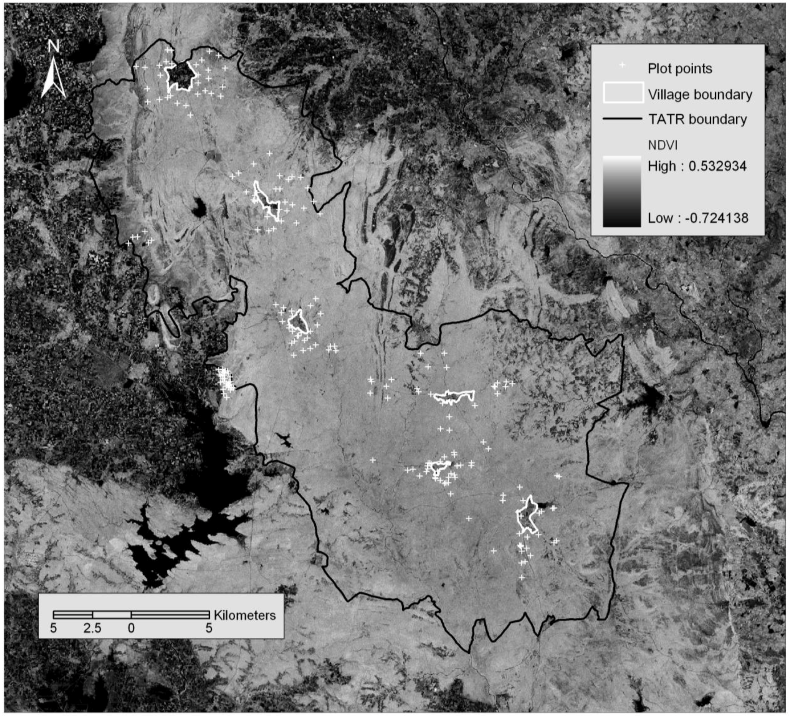
3. Materials and Methods
3.1. Data Gathering
3.1.1. Field data collection
3.1.2. Image data acquisition and pre-processing
3.2. Data Analysis: Relationship Between Spectral and Plant Biodiversity Data
4. Results

| Spectral variable | Total species richness | Tree species richness | Tree Shannon diversity | Number of trees |
|---|---|---|---|---|
| Band 1 Mean | −0.328*** | −0.275*** | −0.297*** | −0.066 |
| Band 1 Standard Deviation | −0.118 | −0.152* | −0.125 | −0.112 |
| Band 2 Mean | −0.336*** | −0.316*** | −0.336*** | −0.105 |
| Band 2 Standard Deviation | −0.263*** | −0.281*** | −0.225*** | −0.242*** |
| Band 3 Mean | −0.293*** | −0.251*** | −0.26*** | −0.091 |
| Band 3 Standard Deviation | −0.139* | −0.131 | −0.129 | −0.045 |
| Band 4 Mean | −0.172* | −0.142* | −0.186** | 0.019 |
| Band 4 Standard Deviation | −0.146* | −0.135 | −0.167* | −0.075 |
| Band 5 Mean | −0.246*** | −0.255*** | −0.268*** | −0.115 |
| Band 5 Standard Deviation | −0.137* | −0.142* | −0.151* | −0.068 |
| Band 7 Mean | −0.254*** | −0.25*** | −0.26*** | −0.112 |
| Band 7 Standard Deviation | −0.093 | −0.105 | −0.117 | −0.039 |
| Panchromatic Band Mean | −0.276*** | −0.263*** | −0.269*** | −0.133 |
| Panchromatic Band Standard Deviation | −0.125 | −0.115 | −0.138* | −0.013 |
| Brightness Mean | −0.305*** | −0.278*** | −0.307*** | −0.077 |
| Brightness Standard Deviation | −0.181** | −0.179** | −0.179** | −0.108 |
| Greenness Mean | 0.202** | 0.192** | 0.18** | 0.112 |
| Greenness Standard Deviation | −0.101 | −0.107 | −0.123 | −0.007 |
| Wetness Mean | 0.228*** | 0.241*** | 0.25*** | 0.118 |
| Wetness Standard Deviation | −0.12 | −0.131 | −0.142* | −0.061 |
| NDVI Mean | 0.166* | 0.144* | 0.125 | 0.087 |
| NDVI Standard Deviation | −0.089 | −0.098 | −0.105 | −0.021 |
| IRI Mean | 0.119 | 0.154* | 0.138* | 0.117 |
| IRI Standard Deviation | −0.041 | −0.041 | −0.063 | 0.004 |
| MIRI Mean | 0.22** | 0.193** | 0.193** | 0.092 |
| MIRI Standard Deviation | 0.01 | −0.004 | −0.036 | 0.001 |
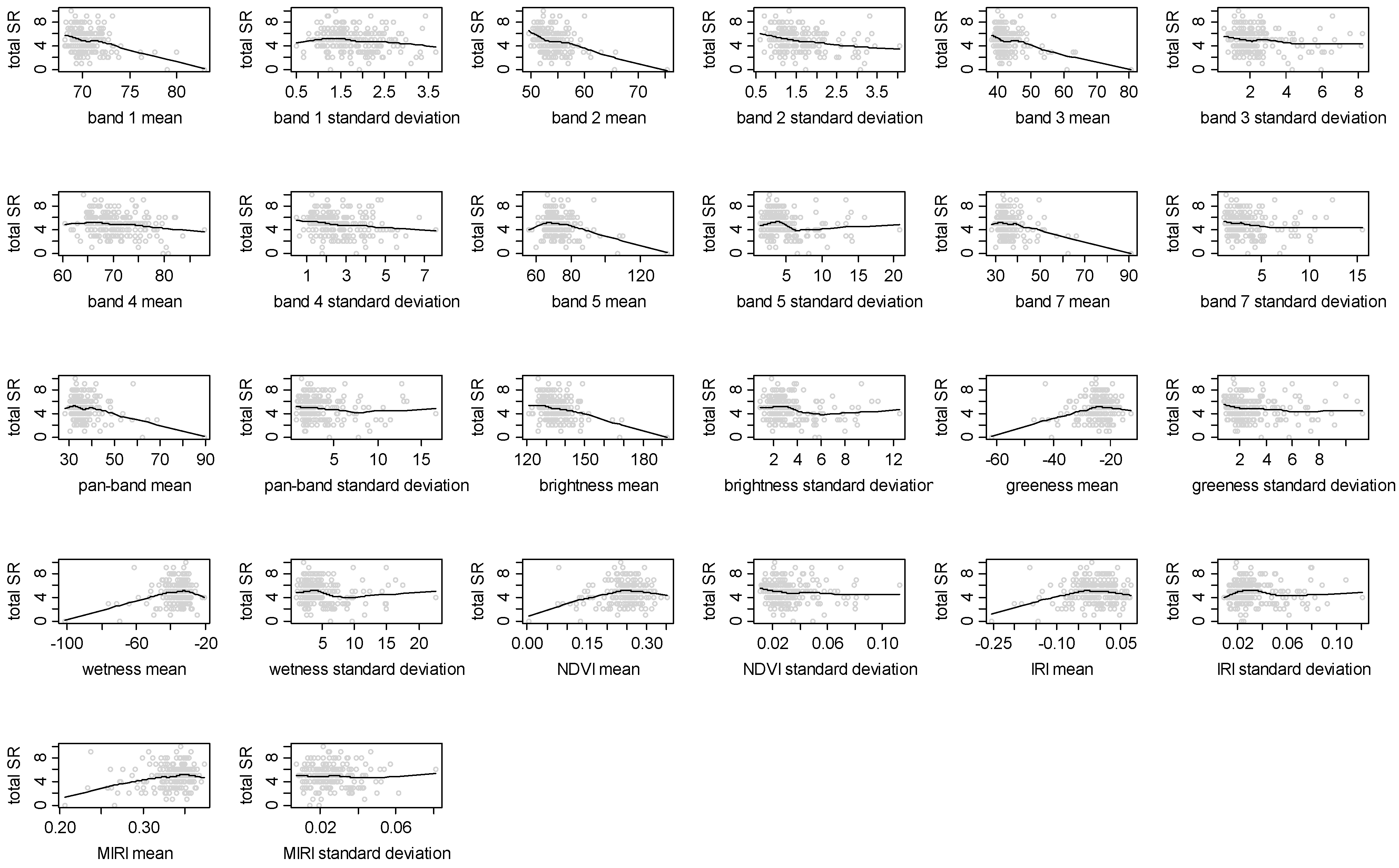
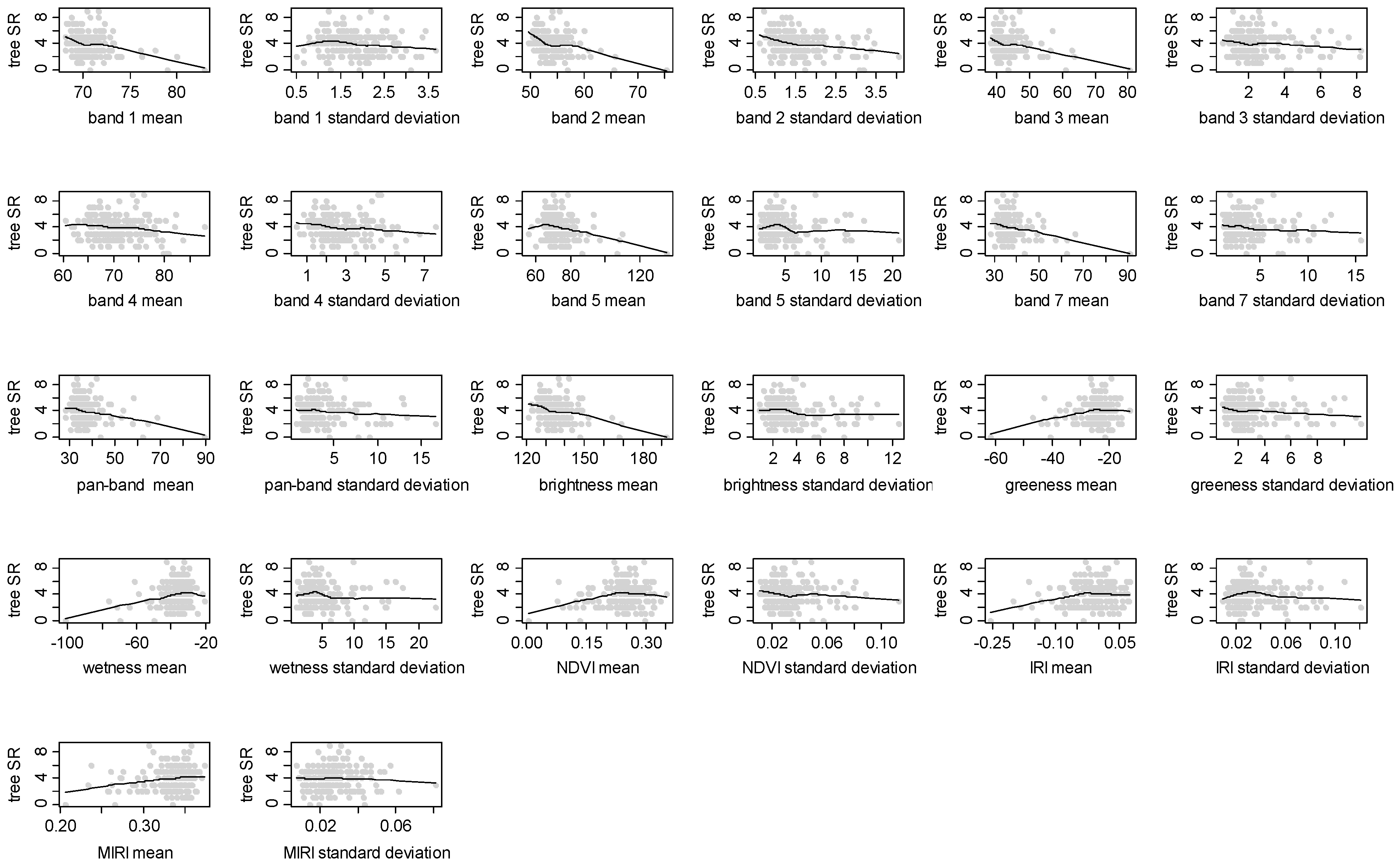
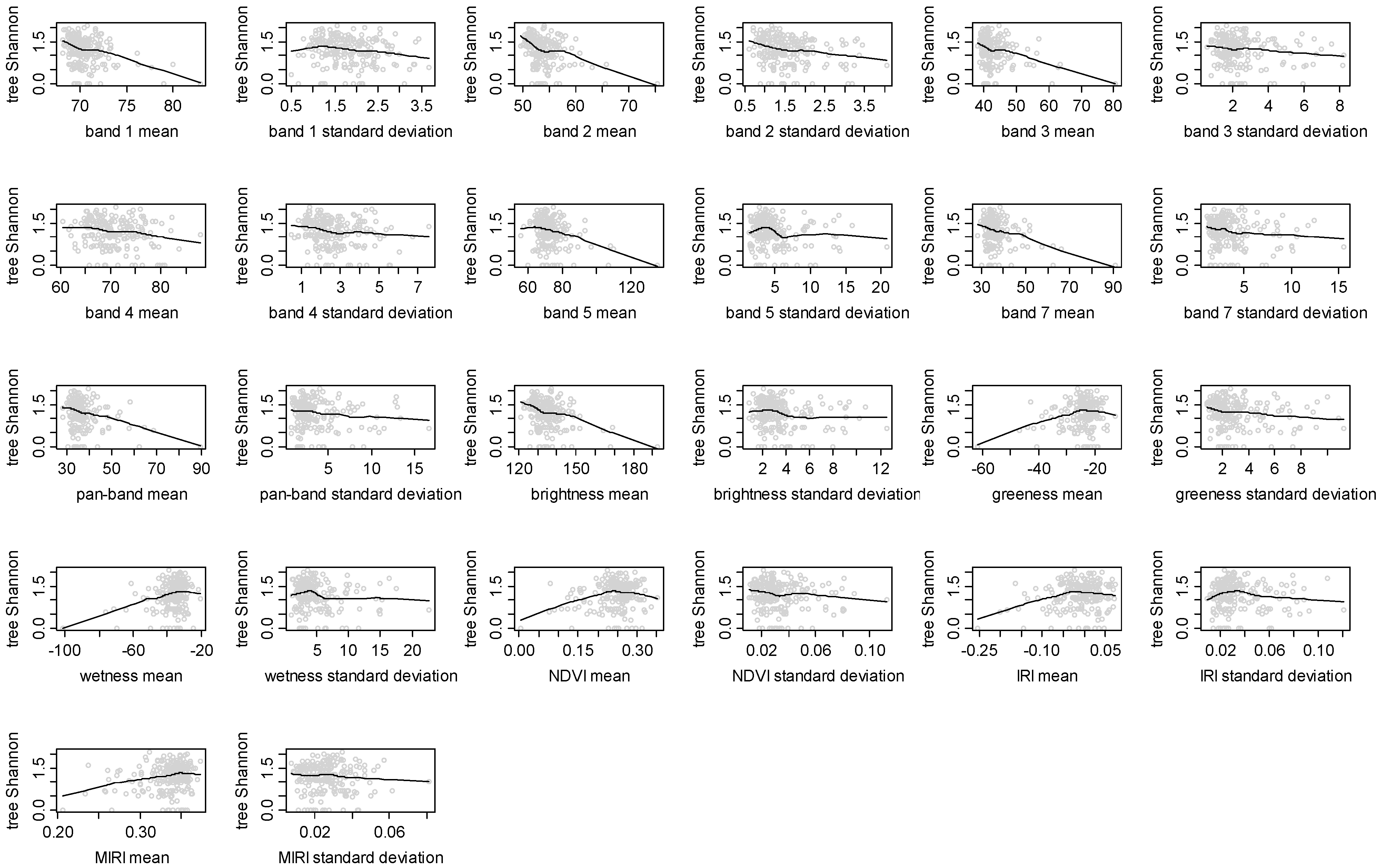
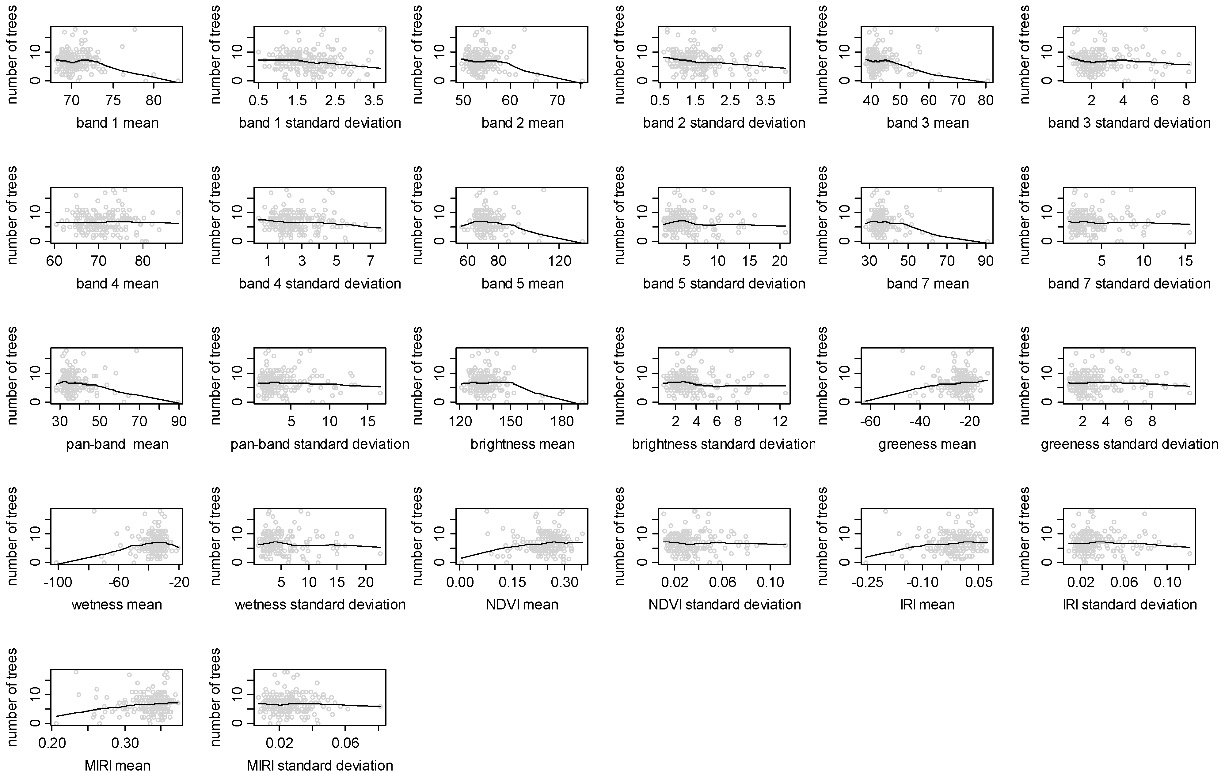
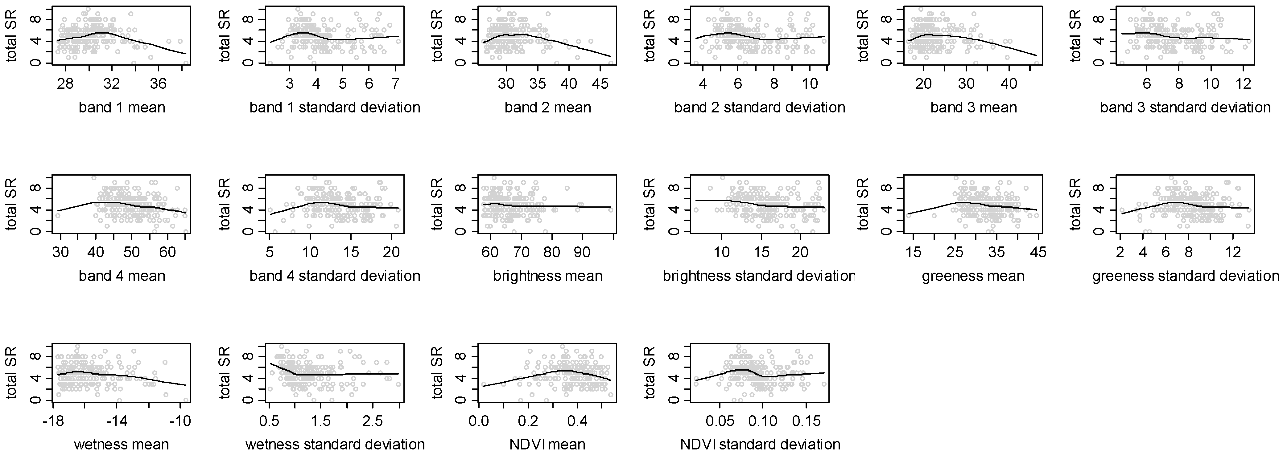
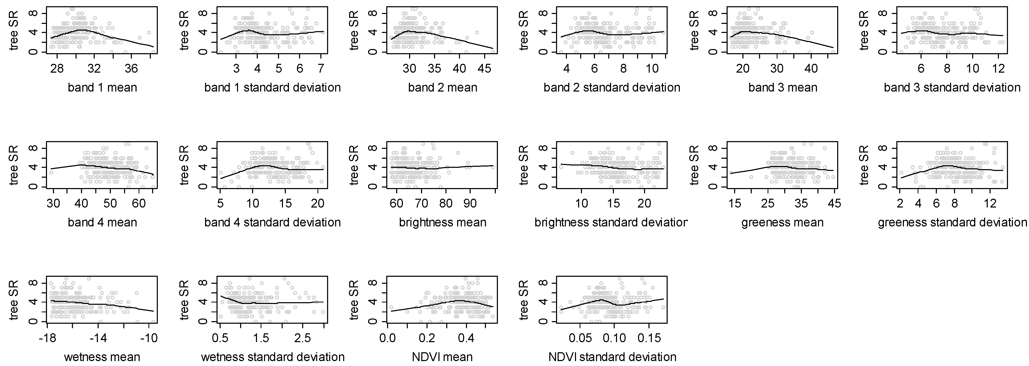
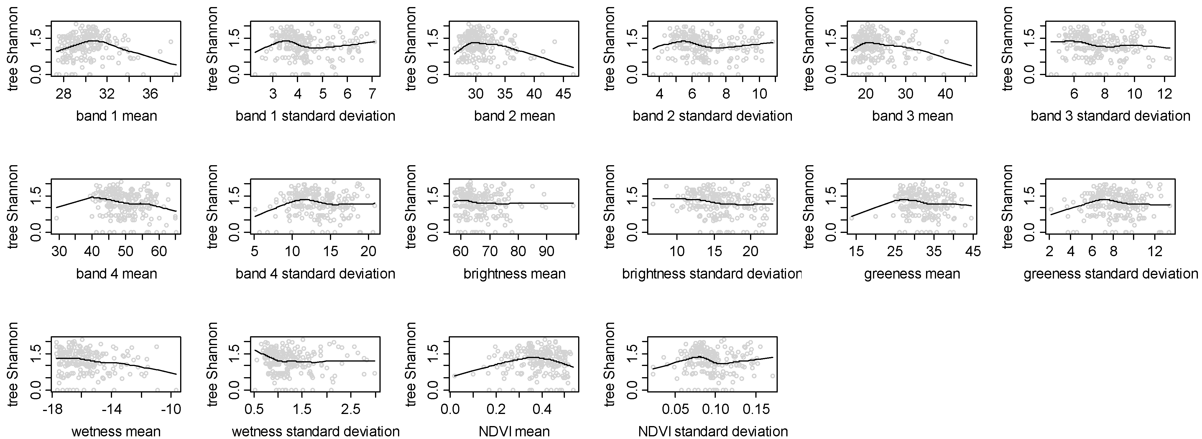
| Spectral variable | Total species richness | Tree species richness | Tree Shannon diversity | Number of trees |
|---|---|---|---|---|
| Band 1 Mean | −0.018 | −0.041 | −0.012 | −0.131 |
| Band 1 Standard Deviation | −0.118 | −0.007 | −0.050 | 0.198*** |
| Band 2 Mean | −0.133 | −0.148* | −0.129 | −0.159* |
| Band 2 Standard Deviation | −0.127 | −0.021 | −0.066 | 0.183*** |
| Band 3 Mean | −0.149* | −0.159* | −0.142* | −0.138* |
| Band 3 Standard Deviation | −0.140* | −0.044 | −0.090 | 0.158* |
| Band 4 Mean | −0.235*** | −0.149* | −0.181** | 0.016 |
| Band 4 Standard Deviation | −0.080 | 0.012 | −0.056 | 0.175* |
| Brightness Mean | −0.080 | −0.008 | −0.050 | 0.131 |
| Brightness Standard Deviation | −0.187** | −0.127 | −0.175** | 0.051 |
| Greenness Mean | −0.164* | −0.069 | −0.110 | 0.086 |
| Greenness Standard Deviation | −0.068 | 0.026 | −0.049 | 0.166* |
| Wetness Mean | −0.169* | −0.192** | −0.176** | −0.119 |
| Wetness Standard Deviation | −0.114 | −0.056 | −0.098 | 0.057 |
| NDVI Mean | −0.020 | 0.042 | 0.012 | 0.099 |
| NDVI Standard Deviation | −0.106 | 0.011 | −0.054 | 0.235*** |
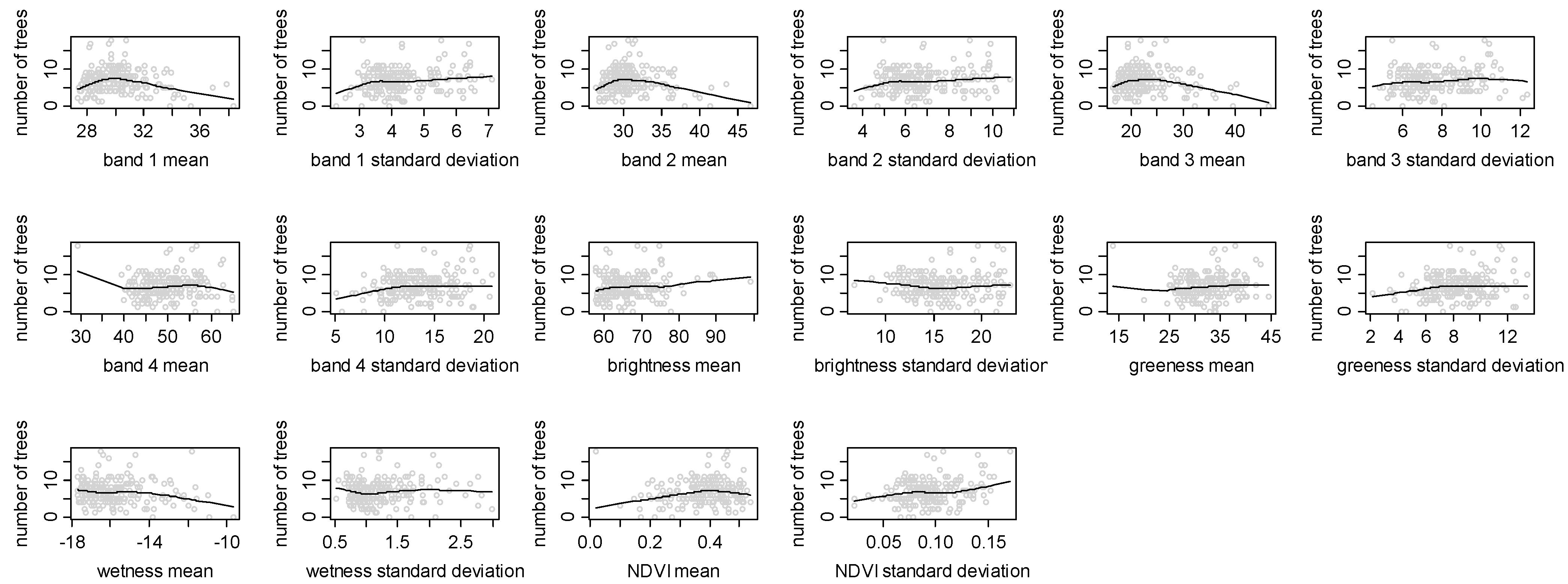
5. Discussion
Acknowledgements
References
- Kerr, J.T.; Ostrovsky, M. From space to species: ecological applications for remote sensing. Trends Ecol. Evol. 2003, 18, 299–305. [Google Scholar] [CrossRef]
- Carter, G.A.; Lucas, K.L.; Blossom, G.A.; Lassitter, C.L.; Holiday, D.M.; Mooneyhan, D.S.; Fastring, D.R.; Holcombe, T.R.; Griffith, J.A. Remote sensing and mapping of tamarisk along the Colorado river, USA: a comparative use of summer-acquired Hyperion, Thematic Mapper and QuickBird data. Remote Sens. 2009, 1, 318–329. [Google Scholar] [CrossRef]
- Prasad, P.R.C.; Nagabhatla, N.; Reddy, C.S.; Gupta, S.; Rajan, K.S.; Raza, S.H.; Dutt, C.B.S. Assessing forest canopy closure in a geospatial medium to address management concerns for tropical islands—Southeast Asia. Environ. Monit. Assess. 2009. [Google Scholar] [CrossRef] [PubMed]
- Wang, L.; Sousa, W.P.; Gong, P.; Biging, G. Comparison of IKONOS and QuickBird images for mapping mangrove species on the Caribbean coast of Panama. Remote Sens. Environ. 2004, 91, 432–440. [Google Scholar] [CrossRef]
- Everitt, J.J.; Fletcher, R.S.; Elder, H.S.; Yang, C. Mapping giant salvinia with satellite imagery and image analysis. Environ. Monit. Assess. 2008, 139, 35–40. [Google Scholar] [CrossRef] [PubMed]
- Duro, D.C.; Coops, N.C.; Wulder, M.A.; Han, T. Development of a large area biodiversity monitoring system driven by remote sensing. Prog. Phys. Geogr. 2007, 31, 253–260. [Google Scholar] [CrossRef]
- Nagendra, H.; Rocchini, D. Satellite imagery applied to biodiversity study in the tropics: the devil is in the detail. Biodiv. Conserv. 2008, 17, 3431–3442. [Google Scholar] [CrossRef]
- Nagendra, H.; Gadgil, M. Satellite imagery as a tool for monitoring species diversity: an assessment. J. Appl. Ecol. 1999, 36, 388–397. [Google Scholar] [CrossRef]
- Sanchez-Azofeifa, G.A.; Castro, K.L.; Rivard, B.; Kalascka, M.R.; Harriss, R.C. Remote sensing research priorities in tropical dry forest environments. Biotropica 2003, 35, 134–142. [Google Scholar] [CrossRef]
- Loarie, S.R.; Joppa, L.N.; Pimm, S.L. Satellites miss environmental priorities. Trends Ecol. Evol. 2007, 22, 630–632. [Google Scholar] [CrossRef] [PubMed]
- Nagendra, H. Using remote sensing to assess biodiversity. Int. J. Remote Sens. 2001, 22, 2377–2400. [Google Scholar] [CrossRef]
- Turner, B.L., II; Lambin, E.F.; Reenberg, A. The emergence of land change science for global environmental change and sustainability. Proc. Natl. Acad. Sci. USA 2008, 104, 20666–20671. [Google Scholar] [CrossRef] [PubMed]
- Read, J.M.; Clark, D.B.; Venticinque, E.M.; Moreiras, M.P. Application of merged 1-m and 4-m resolution satellite data to research and management in tropical forests. J. Appl. Ecol. 2003, 40, 592–600. [Google Scholar] [CrossRef]
- Kovacs, J.M.; King, J.M.L.; de Santiago, F.F.; Flores-Verdugo, F. Evaluating the condition of a mangrove forest of the Mexican Pacific based on an estimated leaf area index mapping approach. Environ. Monit. Assess. 2008. [Google Scholar] [CrossRef] [PubMed]
- Everitt, J.J.; Yang, C.; Johnson, H.B. Canopy spectra and remote sensing of Ashe juniper and associated vegetation. Environ. Monit. Assess. 2007, 130, 403–413. [Google Scholar] [CrossRef] [PubMed]
- Levin, N.; Shmida, A.; Levanoni, O.; Tamari, H.; Kark, S. Predicting mountain plant richness and rarity from space using satellite-derived vegetation indices. Divers. Distrib. 2007, 13, 692–703. [Google Scholar] [CrossRef]
- Rocchini, D. Effects of spatial and spectral resolution in estimating ecosystem α-diversity by satellite imagery. Remote Sens. Environ. 2007, 111, 423–434. [Google Scholar] [CrossRef]
- Warren, A.J.; Collins, M.J. A pixel-based semiempirical system for predicting vegetation diversity in boreal forest. Int. J. Remote Sens. 2007, 28, 83–105. [Google Scholar] [CrossRef]
- Curran, P.J. Remote sensing of foliar chemistry. Remote Sens. Environ. 1989, 30, 271–278. [Google Scholar] [CrossRef]
- Martin, M.E.; Aber, J.D. High spectral resolution remote sensing of forest canopy lignin, nitrogen, and ecosystem processes. Ecol. Appl. 1997, 7, 431–443. [Google Scholar] [CrossRef]
- Cochrane, M.A. Using vegetation reflectance variability for species level classification of hyperspectral data. Int. J. Remote Sens. 2000, 21, 2075–2087. [Google Scholar] [CrossRef]
- Clark, M.; Roberts, D.A.; Clark, D.B. Hyperspectral discrimination of tropical rain forest tree species at leaf to crown scales. Remote Sens. Environ. 2005, 96, 375–398. [Google Scholar] [CrossRef]
- Leimgruber, P.; Christen, C.A.; Laborderie, A. The impact of Landsat satellite monitoring on conservation biology. Environ. Monit. Assess. 2005, 106, 81–101. [Google Scholar] [CrossRef] [PubMed]
- Feeley, K.J.; Gillespie, T.W.; Terborgh, J.W. The utility of spectral indices from Landsat ETM+ for measuring the structure and composition of tropical dry forests. Biotropica 2005, 37, 508–519. [Google Scholar] [CrossRef]
- Nagendra, H.; Pareeth, S.; Ghate, R. People within parks: Forest villages and fragmentation in the Tadoba-Andhari Tiger Reserve, India. Appl. Geogr. 2006, 26, 96–112. [Google Scholar] [CrossRef]
- Jensen, J.R. Remote Sensing of the Environment: An Earth Resource Perspective; Prentice Hall: New Jersey, NJ, USA, 2000. [Google Scholar]
- Legendre, P.; Legendre, L. Numerical Ecology, Second English Edition; Elsevier Science BV: Amsterdam, The Netherlands, 1998. [Google Scholar]
- Oza, M.P.; Srivastava, V.K.; Devaiah, P.K. Estimating tree volume in tropical dry deciduous forest from Landsat TM data. Geocarto Int. 1996, 1, 33–39. [Google Scholar] [CrossRef]
- Bawa, K.; Rose, J.; Ganeshaiah, K.N.; Barve, N.; Kiran, M.C.; Umashaankar, R. Assessing biodiversity from space: an example from the Western Ghats, India. Conserv. Ecol. 2002, 6, 7. Available online at: http://wwwconsecolorg/vol6/iss2/art7 (accessed on 9 May 2008). [Google Scholar]
- Sokal, R.R.; Rohlf, F.J. Biometry, 3rd ed.; Freeman: New York, NY, USA, 1995. [Google Scholar]
- Cleveland, W.S. Robust locally weighted regression and smoothing scatterplots. J. Am. Stat. Assoc. 1979, 74, 829–836. [Google Scholar] [CrossRef]
- Cleveland, W.S.; Devlin, S.J. Locally weighted regression: an approach to regression analysis by local fitting. J. Am. Stat. Assoc. 1988, 83, 596–610. [Google Scholar] [CrossRef]
- Crawley, M.J. Statistics: An Introduction Using R; Wiley & Sons: Chichester, UK, 2005. [Google Scholar]
- R Development Core Team. R: A Language and Environment for Statistical Computing; R Foundation for Statistical Computing: Vienna, Austria, 2008. [Google Scholar]
- Fraser, C.S.; Dial, G.; Grodecki, J. Sensor orientation via RPCs. ISPRS J. Photogramm. Remote Sens. 2006, 60, 182–194. [Google Scholar] [CrossRef]
- Wu, J.; Wang, D.; Bauer, M.E. Image-based atmospheric correction of QuickBird imagery of Minnesota cropland. Remote Sens. Environ. 2005, 99, 315–325. [Google Scholar] [CrossRef]
- Sohn, G.; Dowman, I. Data fusion of high-resolution satellite imagery and LiDAR data for automatic building extraction. ISPRS J. Photogramm. Remote Sens. 2007, 62, 43–63. [Google Scholar] [CrossRef]
- Jakubauskas, M.E.; Price, K.P. Empirical relationships between structural and spectral factors of Yellowstone Lodgepole Pine forests. Photogramm. Eng. Remote Sens. 1997, 63, 1375–1381. [Google Scholar]
- Gillespie, T.W. Predicting woody-plant species richness in tropical dry forests: a case study from South Florida, USA. Ecol. Appl. 2005, 15, 27–37. [Google Scholar] [CrossRef]
- Che, X.; Vierling, L.; Rowell, E.; DeFelice, T. Using lidar and effective LAI data to evaluate IKONOS and Landsat 7 ETM+ vegetation cover estimates in a ponderosa pine forest. Remote Sens. Environ. 2004, 91, 14–26. [Google Scholar]
- Gillespie, T.W.; Foody, G.M.; Rocchini, D.; Giorgi, A.P.; Saatchi, S. Measuring and modeling biodiversity from space. Prog. Phys. Geogr. 2008, 32, 203–221. [Google Scholar] [CrossRef]
- Hernandez-Stefanoni, J.L.; Dupuy, J. Mapping species density of trees, shrubs and vines in a tropical forest, using field measurements, satellite multispectral imagery and spatial interpolation. Biodiv. Conserv. 2007, 16, 3817–3833. [Google Scholar] [CrossRef]
- Gougeon, F.A. Comparison of possible multispectral classification schemes for tree crowns individually delineated on high spatial resolution MEIS images. Can. J. Remote Sens. 1995, 21, 1–9. [Google Scholar] [CrossRef]
- Biging, G.S.; Dobbertin, M.; Murphy, E.C. A test of airborne multispectral videography for assessing the accuracy of wildlife habitat maps. Can. J. Remote Sens. 1995, 21, 357–366. [Google Scholar] [CrossRef]
- Meyer, P.; Staenz, K.; Itten, K.I. Semi-automated procedures for tree species identification in high spatial resolution data from digitised colour infrared-aerial photography. ISPRS J. Photogramm. Remote Sens. 1996, 51, 5–16. [Google Scholar] [CrossRef]
- Woodcock, C.E.; Strahler, A.H. The factor of scale in remote sensing. Remote Sens. Environ. 1987, 21, 311–332. [Google Scholar] [CrossRef]
- Ricotta, C.; Avena, G.C.; Volpe, F. The influence of principal component analysis on the spatial structure of a multispectral dataset. Int. J. Remote Sens. 1999, 20, 3367–3376. [Google Scholar]
- Freitas, S.R.; Mello, M.C.S.; Cruz, C.B.M. Relationships between forest structure and vegetation indices in Atlantic Rainforest. Forest Ecol. Manage. 2005, 218, 353–362. [Google Scholar] [CrossRef]
- Puhr, C.B.; Donoghue, D.N.M. Remote sensing of upland conifer plantations using Landsat TM data: A case study from Galloway, south-west Scotland. Int. J. Remote Sens. 2000, 21, 633–646. [Google Scholar] [CrossRef]
- Ingram, J.C.; Dawson, T.P.; Whittaker, R.J. Mapping tropical forest structure in southeastern Madagascar using remote sensing and artificial neural networks. Remote Sens. Environ. 2005, 94, 491–507. [Google Scholar] [CrossRef]
- Gould, W. Remote sensing of vegetation, plant species richness, and regional biodiversity hotspots. Ecol. Appl. 2000, 10, 1861–1870. [Google Scholar] [CrossRef]
- Goetz, S. Crisis in Earth observation. Science 2007, 315, 1767. [Google Scholar] [CrossRef] [PubMed]
- Kark, S.; Levin, N.; Phinn, S. Global environmental priorities: making sense of remote sensing: reply to TREE Letter: satellites miss environmental priorities by Loarie et al. (2007). Trends Ecol. Evol. 2008, 23, 181–182. [Google Scholar] [CrossRef] [PubMed]
- Srikantia, S.V. Restriction on maps: a denial of valid geographic information. Curr. Sci. 2000, 79, 484–488. [Google Scholar]
© 2010 by the authors; licensee Molecular Diversity Preservation International, Basel, Switzerland. This article is an open-access article distributed under the terms and conditions of the Creative Commons Attribution license (http://creativecommons.org/licenses/by/3.0/).
Share and Cite
Nagendra, H.; Rocchini, D.; Ghate, R.; Sharma, B.; Pareeth, S. Assessing Plant Diversity in a Dry Tropical Forest: Comparing the Utility of Landsat and Ikonos Satellite Images. Remote Sens. 2010, 2, 478-496. https://doi.org/10.3390/rs2020478
Nagendra H, Rocchini D, Ghate R, Sharma B, Pareeth S. Assessing Plant Diversity in a Dry Tropical Forest: Comparing the Utility of Landsat and Ikonos Satellite Images. Remote Sensing. 2010; 2(2):478-496. https://doi.org/10.3390/rs2020478
Chicago/Turabian StyleNagendra, Harini, Duccio Rocchini, Rucha Ghate, Bhawna Sharma, and Sajid Pareeth. 2010. "Assessing Plant Diversity in a Dry Tropical Forest: Comparing the Utility of Landsat and Ikonos Satellite Images" Remote Sensing 2, no. 2: 478-496. https://doi.org/10.3390/rs2020478
APA StyleNagendra, H., Rocchini, D., Ghate, R., Sharma, B., & Pareeth, S. (2010). Assessing Plant Diversity in a Dry Tropical Forest: Comparing the Utility of Landsat and Ikonos Satellite Images. Remote Sensing, 2(2), 478-496. https://doi.org/10.3390/rs2020478

