


Environ. Sci. Proc. 2024, 29(1), 70; https://doi.org/10.3390/ECRS2023-16860 - 6 Jun 2024
Abstract
►
Show Figures
The statistical characteristics of combined lidar and radiometric measurements obtained from satellite lidar CALIOP and ground-based sun-radiometer stations were used as input datasets to retrieve the altitude profiles of aerosol parameters (LRS-C technique). The signal-to-noise ratio of the input satellite lidar signals increased
[...] Read more.
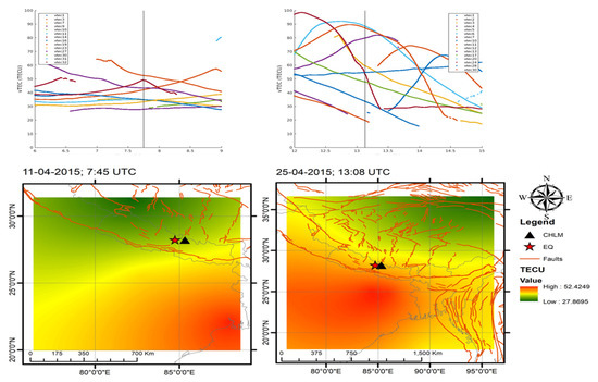
The statistical characteristics of combined lidar and radiometric measurements obtained from satellite lidar CALIOP and ground-based sun-radiometer stations were used as input datasets to retrieve the altitude profiles of aerosol parameters (LRS-C technique). The signal-to-noise ratio of the input satellite lidar signals increased when averaging over a large array of measured data. An algorithm and software package for processing the input dataset of the LRS-C sounding of atmospheric aerosol in regions with medium and low aerosol loads was developed. This paper presents the results of studying long-term changes in the concentration profiles of aerosol modes in regions of East Europe (AERONET site Minsk, 53.92° N, 27.60° E) and East Antarctic (AERONET site Vechernaya Hill, 67.66° S, 46.16° E).
Full article

Figure 1


