13 pages, 6057 KiB  
Article
Exemplifying Stratified Deforestation in Four Protected Areas in Madagascar
by Serge C. Rafanoharana 1,*, Fatany Ollier D. Andrianambinina 2, Henintsoa Andry Rasamuel 1, Mamy A. Rakotoarijaona 2, Jörg U. Ganzhorn 3, Patrick O. Waeber 4 and Lucienne Wilmé 1,*
1 World Resources Institute Africa, 29 Lalana Printsy Ratsimamanga, BP 3884, Antananarivo 101, Madagascar
2 Madagascar National Parks, Ambatobe, BP 1424, Antananarivo 103, Madagascar
3 Tierökologie und Naturschutz Institut Für Zoologie, Universität Hamburg, Martin-Luther-King Platz 3, 20146 Hamburg, Germany
4 Forest Management and Development, Department of Environmental Sciences, Swiss Federal Institute of Technology Zurich, Universitätstrasse 16, ETH Zentrum, CHN F 75.3, 8092 Zurich, Switzerland
Forests 2021, 12(9), 1143; https://doi.org/10.3390/f12091143 - 24 Aug 2021
Cited by 11 | Viewed by 6226
Abstract
Protected areas (PAs) are a cornerstone for conservation biodiversity. Madagascar, as a hotspot for biodiversity, has a network of 114 terrestrial protected areas covering the main forest types occurring on the island. Deforestation continues unabated despite the network covering 11% of the island. [...] Read more.
Protected areas (PAs) are a cornerstone for conservation biodiversity. Madagascar, as a hotspot for biodiversity, has a network of 114 terrestrial protected areas covering the main forest types occurring on the island. Deforestation continues unabated despite the network covering 11% of the island. Here we present a case study approach reporting on four PAs from the humid forests, dry western forests, and southwestern dry and spiny forests and thickets. To describe deforestation in and around the case sites, we have considered a time window of 30 years for analysis, focusing on six years with reliable data: 1990, 2000, 2010, 2015 (the year of latest PA network update), and 2017. We have considered forest versus other land covers within the PAs in “buffers” at a distance of 500 m, 2.5 km, 5 km, and 10 km from the border of the PA. These buffers were set from the border towards the center of the PA (inside the PAs) and from the border outside the PAs. The smallest PAs, Kasijy (IUCN IV), and Behara Tranomaro (no IUCN category), showed the least forest loss. Tsaratanana (IUCN I) had the highest deforestation rates within the last two years of analysis, with deforestation concentrated in the core area. Ranobe PK-32 (no IUCN category), originally with the largest forest extent, has lost most of its forest cover and showed the highest annual deforestation rate (3.5%) between 2015 and 2017. All four cases prove to be very challenging to manage. Future conservation activities require tailored interventions to account for site-specific current and potential future threats, as detailed in this contribution. Full article
(This article belongs to the Special Issue Forests, Their Diversity, and Conservation)
Show Figures

Graphical abstract

16 pages, 3233 KiB  
Article
Implementation of a System for Real-Time Detection and Localization of Terrain Objects on Harvested Forest Land
by Songyu Li * and Håkan Lideskog
Department of Engineering Sciences and Mathematics, Luleå University of Technology, 97187 Luleå, Sweden
Forests 2021, 12(9), 1142; https://doi.org/10.3390/f12091142 - 24 Aug 2021
Cited by 14 | Viewed by 3160
Abstract
Research highlights: An automatic localization system for ground obstacles on harvested forest land based on existing mature hardware and software architecture has been successfully implemented. In the tested area, 98% of objects were successfully detected and could on average be positioned within 0.33 [...] Read more.
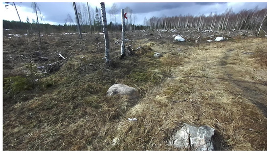
Research highlights: An automatic localization system for ground obstacles on harvested forest land based on existing mature hardware and software architecture has been successfully implemented. In the tested area, 98% of objects were successfully detected and could on average be positioned within 0.33 m from their true position in the full range 1–10 m from the camera sensor. Background and objectives: Forestry operations in forest environments are full of challenges; detection and localization of objects in complex forest terrains often require a lot of patience and energy from operators. Successful automatic real-time detection and localization of terrain objects not only can reduce the difficulty for operators but are essential for the automation of harvesting and logging tasks. We intend to implement a system prototype that can automatically locate ground obstacles on harvested forest land based on accessible hardware and common software infrastructure. Materials and Methods: An automatic object detection and localization system based on stereo camera sensing is described and evaluated in this paper. This demonstrated system detects and locates objects of interest automatically utilizing the YOLO (You Only Look Once) object detection algorithm and derivation of object positions in 3D space. System performance is evaluated by comparing the automatic detection results of the tests to manual labeling and positioning results. Results: Results show high reliability of the system for automatic detection and location of stumps and large stones and shows good potential for practical application. Overall, object detection on test tracks was 98% successful, and positional location errors were on average 0.33 m in the full range from 1–10 m from the camera sensor. Conclusions: The results indicate that object detection and localization can be used for better operator assessment of surroundings, as well as input to control machines and equipment for object avoidance or targeting. Full article
(This article belongs to the Special Issue Digital Transformation and Management in Forest Operations)
Show Figures

Figure 1

16 pages, 60311 KiB  
Article
Biological Legacies and Rockfall: The Protective Effect of a Windthrown Forest
by Maximiliano Costa 1,*, Niccolò Marchi 1, Francesco Bettella 1, Paola Bolzon 1, Frédéric Berger 2 and Emanuele Lingua 1
1 Department of Land, Environment, Agriculture and Forestry (TESAF), University of Padua, 35020 Legnaro, PD, Italy
2 Unité de Recherche Érosion Torrentielle, Neige et Avalanches (INRAE, UR ETNA), French National Research Institute for Agriculture, Food and the Environment, 38402 St-Martin-d’Hères, France
Forests 2021, 12(9), 1141; https://doi.org/10.3390/f12091141 - 24 Aug 2021
Cited by 18 | Viewed by 3355
Abstract
Windstorms represent one of the main large-scale disturbances that shape the European landscape and influence its forest structure, so post-event restoration activities start to gain a major role in mountainous forest management. After a disturbance event, biological legacies may enhance or maintain multiple [...] Read more.
Windstorms represent one of the main large-scale disturbances that shape the European landscape and influence its forest structure, so post-event restoration activities start to gain a major role in mountainous forest management. After a disturbance event, biological legacies may enhance or maintain multiple ecosystem services of mountain forests such as protection against natural hazards, biodiversity conservation, or erosion mitigation. However, the conservation of all these ecosystem services after stand-replacing events could go against traditional management practices, such as salvage logging. Thus far, the impact of salvage logging and removal of biological legacies on the protective function of mountain stands has been poorly studied. Structural biological legacies may provide protection for natural regeneration and may also increase the terrain roughness providing a shielding effect against gravitational hazards like rockfall. The aim of this project is to understand the dynamics of post-windthrow recovery processes and to investigate how biological legacies affect the multifunctionality of mountain forests, in particular the protective function. To observe the role of biological legacies we performed 3000 simulations of rockfall activity on windthrown areas. Results show the active role of biological legacies in preventing gravitational hazards, providing a barrier effect and an energy reduction effect on rockfall activity. To conclude, we underline how forest management should take into consideration the protective function of structural legacies. A suggestion is to avoid salvage logging in order to maintain the multifunctionality of damaged stands during the recovery process. Full article
(This article belongs to the Section Natural Hazards and Risk Management)
Show Figures

Figure 1

15 pages, 3678 KiB  
Article
The Potential Distribution of Juniperus rigida Sieb. et Zucc. Vary Diversely in China under the Stringent and High GHG Emission Scenarios Combined Bioclimatic, Soil, and Topographic Factors
by Zhenjiang Lv 1,2 and Dengwu Li 1,2,*
1 College of Forestry, Northwest A & F University, Yangling, Xianyang 712100, China
2 Shaanxi Key Laboratory of Economic Plant Resources Development and Utilization, Yangling, Xianyang 712100, China
Forests 2021, 12(9), 1140; https://doi.org/10.3390/f12091140 - 24 Aug 2021
Cited by 7 | Viewed by 2128
Abstract
Global warming poses an enormous threat to particular species with shifts to their suitable habitat. Juniperus rigida Sieb. et Zucc., an endemic species to East Asia and a pioneer species in the Loess plateau region, is endangered because of the shrinking and scattered [...] Read more.
Global warming poses an enormous threat to particular species with shifts to their suitable habitat. Juniperus rigida Sieb. et Zucc., an endemic species to East Asia and a pioneer species in the Loess plateau region, is endangered because of the shrinking and scattered habitat threatened by climate change. For the sake of analyzing the impact of climate warming on its possible habitat, we herein projected the current and future potential habitats of J. rigida in China and comparatively analyzed the ecological habitat changes in three main distribution regions. There were 110 specimen records of J. rigida collected across China and 22 environmental datasets, including bioclimatic variables and soil and topographical factors, selected by the Pearson Correlation Coefficient. The MaxEnt model based on specimen presence and environmental factors was used for projecting the potential habitats of J. rigida in China in the 2050s and the 2070s of RCP 2.6 and RCP 8.5 scenarios. The results indicated an excellence model performance with the average value of the area under curve (AUC) is 0.928. The mean temperature of the driest quarter (MTDq) and the temperature annual range (TAR) provided important contributions to the potential distribution of J. rigida. There were three main distribution areas in China, the Xinjiang region, the Loess-Inner Mongolian Plateau region, and the Changbai Mountain region. The distribution increased overall in area under RCP 2.6 and decreased for RCP 8.5. The mean altitude of the core distribution shifted upward in general under both scenarios. The Loess–Inner Mongolian Plateau region is the biggest distribution, encompassing ca. 61.39 × 10⁴ km2 (86.87 × 10⁴ km2 in China). The region threatened most by climate change is located in the Changbai Mountain distribution, with the centroid of the cord suitable habitat migrating southwest about 227.47 and 260.32 km under RCP 2.6 and RCP 8.5 by the 2070s. In summary, these findings provided a well-grounded understanding of the effect of climate change on ecological distribution and furnished theory evidence for the protection, management, and sustainable use of J. rigida. Full article
(This article belongs to the Section Forest Ecology and Management)
Show Figures

Graphical abstract

22 pages, 2085 KiB  
Article
Winners and Losers in Energy Transition: Study Case of Wood Biomass Power-Plants Implementation in France
by Roxane Sansilvestri 1,*, Mateo Cordier 2 and Thibault Lescuyer 2
1 Ecologie-Systématique-Evolution Lab (UMR 8079), Université Paris Saclay, 91400 Orsay, France
2 Cultures-Environnements-Arctique-Représentations-Climat Lab (CEARC), Université de Versailles Saint-Quentin-en-Yvelines, 78280 Guyancourt, France
Forests 2021, 12(9), 1139; https://doi.org/10.3390/f12091139 - 24 Aug 2021
Cited by 5 | Viewed by 3160
Abstract
International policies promote renewable forms of energy to mitigate climate change. In Europe, the production of electricity using wood biomass represents one of the most popular energy alternatives. In 2012, France initiated a large-scale strategy to develop wood biomass energy. The biggest wood [...] Read more.
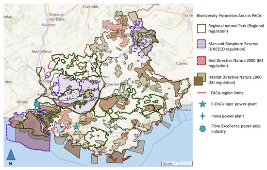
International policies promote renewable forms of energy to mitigate climate change. In Europe, the production of electricity using wood biomass represents one of the most popular energy alternatives. In 2012, France initiated a large-scale strategy to develop wood biomass energy. The biggest wood biomass power-plant project has been developed in the French Mediterranean area and its huge size raises several issues for the short- and long-term sustainability of local forests and associated economic sectors. The French Mediterranean forests provide four types of economic goods (private, club, common, and public goods) and multiple ecosystem services, which makes them complex to manage under an energy transition policy. In this paper, we applied three qualitative methods, namely interviews, participative workshops, and observant participation, and three conceptual models, namely (i) Ostrom’s (2010) self-organization key conditions, (ii) the types of economic goods classified according to their excludability and rivalry properties, and (iii) the ecosystem service categorization system of the Millennium Ecosystem Assessment (2005). With our methods, we show that the renewable strategy chosen in France replicates the current centralized production model based on fossil and nuclear fuels. Thus, we demonstrate that European, national, and local authorities fail to consider the multiple ecosystem services that forest management strategies should include to face the energy transition, climate change, and the other ecological challenges of the 21st century. Full article
Show Figures

Figure 1

12 pages, 745 KiB  
Article
How Much Is the Abandonment of Forest Management in Private Forests Worth? A Case of Poland
by Piotr Tadeusz Gołos 1, Joanna Ukalska 2, Emilia Wysocka-Fijorek 3,* and Wojciech Gil 4
1 Forest Research Institute, Sękocin Stary, 3 Braci Leśnej Street, 05-090 Raszyn, Poland
2 Laboratory of Dendrometry and Forest Productivity, Department of Forest Management Planning, Dendrometry and Forest Economics, Institute of Forest Sciences, Warsaw University of Life Sciences, Nowoursynowska 159, 02-776 Warsaw, Poland
3 Department of Forest Resources Management, Forest Research Institute, Sękocin Stary, 3 Braci Leśnej Street, 05-090 Raszyn, Poland
4 Department of Silviculture and Genetics of Forest Trees, Forest Research Institute, Sękocin Stary, 3 Braci Leśnej Street, 05-090 Raszyn, Poland
Forests 2021, 12(9), 1138; https://doi.org/10.3390/f12091138 - 24 Aug 2021
Cited by 6 | Viewed by 2795
Abstract
The provision of forest ecosystem services (such as biodiversity, water and soil protection, and recreation) is often associated with a reduction in timber harvesting. In the case of private forests, such a situation requires institutional solutions that allow the economic balance of forest [...] Read more.
The provision of forest ecosystem services (such as biodiversity, water and soil protection, and recreation) is often associated with a reduction in timber harvesting. In the case of private forests, such a situation requires institutional solutions that allow the economic balance of forest management to be maintained. The aim of the study was to find out the average value of monetary compensation private forest owners would expect in case of timber harvesting restrictions. The study was conducted with a random sample of 1003 forest landowners. The average value of expected compensation ranged from PLN 2300/year/ha (which corresponds to the price of about 12 m3 of wood in Poland) under the condition of no restrictions on timber harvesting but the need to apply indicated of forest management methods, to PLN 4900/year/ha in the model assuming a total ban on harvesting. In general, higher compensation was expected by farmers who stated that they sold timber and those whose agricultural area was larger than the average in Poland. When harvesting restrictions are low, the expected compensation is influenced by the age and gender of the respondent, or the number of people in the household. Full article
(This article belongs to the Special Issue Innovation Strategies and Their Impact on Forest Policy)
21 pages, 12614 KiB  
Article
Climate-Driven Differences in Growth Performance of Cohabitant Fir and Birch in a Subalpine Forest in Dhorpatan Nepal
by Raju Bista 1,*, Parveen K. Chhetri 1, Jeremy S. Johnson 2, Ashish Sinha 1 and Krishna B. Shrestha 3
1 Department of Earth Science and Geography, California State University Dominguez Hills, Carson, CA 90747, USA
2 Department of Environmental Studies, Prescott College, Prescott, AZ 86301, USA
3 Department of Biological Sciences, University of Bergen, N 5020 Bergen, Norway
Forests 2021, 12(9), 1137; https://doi.org/10.3390/f12091137 - 24 Aug 2021
Cited by 12 | Viewed by 3413
Abstract
Himalayan Silver Fir (Abies spectabilis) and Himalayan Birch (Betula utilis) are tree species often found coexisting in sub-alpine forests of the Nepal Himalayas. To assess species-specific growth performances of these species, tree-ring samples were collected from the subalpine forest [...] Read more.
Himalayan Silver Fir (Abies spectabilis) and Himalayan Birch (Betula utilis) are tree species often found coexisting in sub-alpine forests of the Nepal Himalayas. To assess species-specific growth performances of these species, tree-ring samples were collected from the subalpine forest in the Dhorpatan Hunting Reserve, Nepal. Standard ring width chronologies of both species were correlated with climatic variables in both static and running windows. Differential and contrasting temporal responses of radial growth of these species to climate were found. Warmer and drier springs appeared to limit birch radial growth. Whereas radial growth of fir showed weakened climate sensitivity. Moving correlation analyses revealed divergent influences of spring climate on both fir and birch. Significant warming that occurred in the 1970s coincided with growth declines in birch and an increase in fir, as indicated by basal area increment. In summary, recent warming has been unfavorable for birch, and favorable to fir radial growth. Full article
(This article belongs to the Section Forest Ecology and Management)
Show Figures

Figure 1