1. Introduction
Landslides along the Danube, on the territory of Vojvodina (Serbia), occurred on the northern slopes of Fruška Gora Mountain. Fruška Gora is a low mountain in the Pannonia Plain. It is of elongated shape, with a length of approximately 40 km and a width of about 15 km. Its genesis is related to tectonic activities in the earth’s crust and the rise of its central area over relatively long faults. Fruška Gora is a horst-type mountain, and its large part has been declared a national park. Some researchers [
1] hypothesized that the rise of fault blocks directly affects the activation of sliding processes. The whole area of Fruska Gora is intersected by streams. Its entire periphery is surrounded by smaller and larger settlements, including the city of Novi Sad. Landslides endanger significant infrastructural facilities, constraining the expansion of populated areas or endangering the stability of individually built structures. The most interesting thing about this is the Bocke landslide, with about 1000 vacation homes declared a part of Novi Sad in the previous period. There are a number of landslides formed on Fruška Gora, particularly on its northern slopes, which are generally inclined toward the Danube River [
2,
3]. A more detailed exploration of these landslides began in the middle of the last century. This was the time when the construction of railways and roads intensified, in some places, on the landslides.
The current level of landslide exploration enables us to classify them into two major groups: deep and shallow landslides. In this study, landslides near the Danube are analyzed in a manner similar to the studies performed in the literature [
4,
5,
6,
7,
8,
9,
10]. Deep landslides are those situated along the river, afflicting a large area that is difficult to repair. They are typically more than 20 m deep. Landslides are usually named after the closest settlement, for example, Beška, Bocke, Sremska Kamenica, Sremski Karlovci, Čortanovci, etc. This paper points out the fact that these are unstable slopes extending several kilometers in length along the Danube area. These unstable slopes consist of a great number of smaller but deep landslides. Their displacements vary in time as well as in amount and direction [
11].
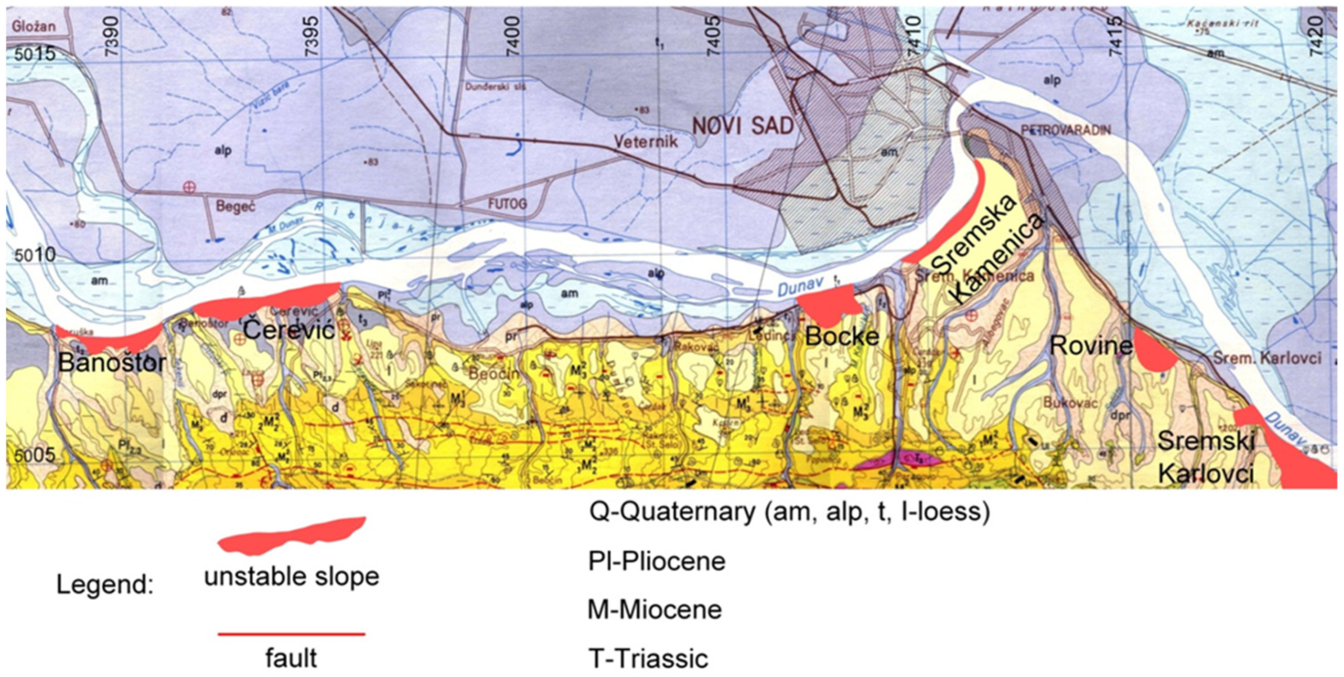
Figure 1 shows the locations of the largest unstable slopes along the Danube in Vojvodina.
The number of shallow landslides is particularly high in the surface zone of the terrain on slopes with deep landslides. Shallow landslides are stressed around the perimeter of unstable slopes, indicating the expansion of the sliding process along the slope. Upon the reparation of these shallow landslides, displacements will continue along the deep sliding planes.
This paper presents the results of landslide investigations in a relatively large area conducted over a long period of time. That is why some landslides, particularly those in the zone of large bridges on the Danube, were examined in great detail, while many others were investigated superficially, that is, only in the form of mapping. The most detailed investigations were started in the area of the Beška bridge on the Belgrade–Novi Sad highway when significant deformities were observed on the bridge caused by the landslide displacement, which endangered the stability of the bridge. In addition, detailed tests were performed on other landslides mentioned in the paper, which included exploratory drilling, inclinometer measurements of landslide displacements, geodetic measurements of landslide displacement, detailed hydrogeological investigations of landslides, geotechnical investigations of landslides in the phase of designing remediation measures, and laboratory geomechanical tests.
2. Geological Settings
The Danube area in the zone of Fruška Gora Mountain was considered (
Figure 2). Given the presence of many types of lithogenic rocks and the emphasized tectonic relationships between them, Fruška Gora has a complex geological structure [
1,
12], especially when compared with the surrounding terrains. The serpentinites are the oldest. They are products of altered gabbro-peridotites, which are of the Paleozoic age. Apart from serpentinite, other Paleozoic rocks are also present: phyllites, schists, mica, chlorite, and amphibole. The direction of the schist is, generally speaking, east–west, while the dip is toward the south. On the surface, they appear in the central parts of the mountain. On the north side, the main belt of Paleozoic formations is generally limited by sediments of the upper Cretaceous. In the far western part, it is limited by Miocene sediments and Quaternary sediments in the south. Contact surfaces between serpentinite and Paleozoic schists are tectonic by nature.
The Mesozoic is represented by rocks of the Triassic, Jurassic, and Cretaceous ages. The rocks of the Triassic age (T) are conglomerates, followed by a series of purple and yellow sandstone, purple, gray, and yellow clay shales, and clayey sandstones, as well as limestones. The upper Cretaceous (K) is represented by basal conglomerates and breccias, coarse-grained sandstones, gray shales, and marls, which alternate with sandstones and conglomerates, limestones, and limy marls.
Miocene sediments are fully developed. The lower Miocene is represented by basal conglomerates, breccias, and various sandstones. The middle Miocene consists of conglomerates, sandstones, sandy marls, tufo-sands, and clayey limestones. The upper Miocene consists of conglomerates, sandstones, sands, clays, limestone, marl, and marl clays.
Sands and sandy clays dominate the Pliocene, while gravels and lignite are less common. The deeper facies consist of marls and marl clays. The middle Pliocene is represented by multicolored clays. Sands and gravels are present to a much lower extent. The upper Pliocene consists of yellowish sands, brownish sands, silts, and clays (
Figure 2). Deep landslides along the Danube were formed in these Pliocene clays and sands. These sediments are slightly inclined toward the Danube at an angle of about 5°. The main causes of the landslides’ occurrence are sloping layers of clay and sand toward the Danube, groundwater in sands, erosion of the right river bank, thin layers of soft carbon clays, and altered Pliocene sediments by surface influences.
In the Quaternary (Q), sediments on land and in the aquatic environment were deposited. The oldest is the complex of sediments often named as “Srem series” in the scientific literature. It is located below the surface loess. Lithologically observed, they are highly heterogeneous and consist of irregularly alternating clays, sands, and gravels. Loess builds relatively large areas on the northern and especially the southern slopes of Fruška Gora. Morphologically speaking, loess builds the so-called Fruška Gora loess plateau, and the tongue forms inflection zones between Fruška Gora streams. Loess within the inflection zones between streams is narrow and, in some places, extremely thick. For example, at the location of the Čardak water reservoir, its thickness is 23 m. These loess-built inflection zones start from a level of about 400 m and descend to the loess plateaus. The loess plateau encircles Fruška Gora on all sides. Its average elevation is 120–140 m. The loess zone is of variable width. It is the smallest in the north, whereas in the south, loess builds much larger areas all the way down to the lowest Fruška Gora foot, on the Šid–Ruma–Stara Pazova line. The loess contains fossil soil horizons (Laskarev—four fossil soil horizons in Zemun [
13]; Gorjanović-Kramberger—four fossil soil horizons in Srem [
14]; Marković-Marjanović—eight fossil soil horizons in Slankamen [
15]).
Alluvial sediments can be found in the area along the Danube. As a rule, deeper parts of the Danube alluvium are built of gravel and sand. The central part is predominantly built of sands with thin layers of silty sediments and mud, while the surface is predominantly built of silty sediments and, to a lesser extent, silty–sandy and muddy sediments.
Igneous rocks also participate in the structure of Fruška Gora. The following varieties are represented: trachytes, latites, altered peridotites, volcanic tuffs, dacito-andesites, melafirs, diabases, and gabbro. They appear in the form of intrusive penetration, in the form of wires, concordant breakthroughs, and volcanic outbursts. Igneous rocks are of the Paleozoic, Triassic, Cretaceous, and Tertiary ages.
In neotectonic terms, Fruška Gora is a typical horst incurred with the relative rise along the system of longitudinal faults, running in the east–west direction. In the earlier tectonic stages, this basic structural form was subsequently separated into smaller blocks of various shapes and sizes by transverse and diagonal faults.
According to the analysis of satellite imagery, the most important structures are dozens of kilometers long. These are complex structures of different genesis, geometry, and kinematics (fault zones, stepped faults, large individual faults). A much smaller number of faults run north–south or in other directions. These are short, one-kilometer-long faults. These shorter fault structures are younger, most likely of the Neogenic age [
16].
Quantitative geomorphological analysis—based on the relief’s energy and the relief’s deviations from the theoretical model and its development in time—has confirmed the findings that individual blocks along the faults are moving relatively upward or relatively downward. In this respect, the east–west-oriented faults are of essential importance.
Based on detailed explorations of some tunnel walls excavated in the mountain in flysch sediments of the Upper Cretaceous, trachites, and serpentinites, we found that they contain a number of faults and fault zones. Rock masses are intensely fractured in the fault zone.
The fact is that neotectonic activities have been continuously unfolding to this day. We are still lacking sufficiently precise data and measurements that would explain this complex topic. For the amount and nature of neotectonic movement to be more reliably identified, it is necessary to conduct precise geodetic measurements. In the example of detailed landslide examinations in the area of the Sloboda bridge in Novi Sad, it was confirmed that neotectonic activities do not affect the formation of deep landslides.
The Fruška Gora area is not endangered by very strong earthquakes. Referring back to the period of 50 years, the central area of the mountain belonged to 7° MCS. Referring back to the period of 100–500 years, Fruška Gora belonged to 8° MCS [
12].
It should be noted that despite the area’s relatively favorable seismicity, some microlocations and important buildings require seismic microzonation, thereby correcting the basic degree.
3. The Examples of Several Most Significant Deep Landslides along the Danube on the Fruška Gora Slopes
Deep landslides of this type are the largest and the most important on the northern slopes of Fruška Gora. They emerged on the right valley side of the Danube, from Neštin to Smederevo [
17,
18,
19], almost continuously nearly 100 km in length. In some sections of the aforementioned area, the sliding process is particularly emphasized from Neštin to Susek, from Banoštor to Čerević, western part of Sremska Kamenica and Bocke, from Sremska Kamenica to the Petrovaradin fortress [
16,
20], Puckaroš, Rovine, the eastern part of Sremski Karlovci, Sremski Karlovci–Čortanovci–Beška, etc.
The Danube-type landslides, which cover a large area and are the deepest in Serbia, have been studied by many researchers publishing scientific papers in which theoretical aspects of the terrain instability causes were considered [
21,
22]. Some papers present the results of detailed investigations of landslides on which the following engineering structures were built:
Roadway in the Čerević and Banoštor areas;
The Beška bridge and the Sloboda bridge in Novi Sad;
Bocke water supply and sewerage system;
The R-107 roadway alongside the Petrovaradin Fortress;
Railway line in the areas of Sremski Karlovci and Čortanovci;
A part of Sremski Karlovci, etc.
Some Danube-type landslides were thoroughly studied in several stages and over a long time period (Sloboda bridge; Beška; Čortanovci; Banoštor; Prljuša; Trandžament in Novi Sad; Bocke; Puckaroš). For other landslides, only terrain mapping was performed. Numerous research objectives and tasks were only partly solved or solved only at some microlocations of large, unstable slopes. The opinion of the author of this ongoing study is based on many years of active participation in research activities at several of the most investigated landslides of this type. Investigation work should be present in all phases of engineering design. Also, research and the necessary adjustments of design solutions to actual field conditions should be continued in the stage of performing the landslide reparation [
23,
24].
Table 1 shows the most important unstable slopes with Danube-type landslides. The inspection of this large area revealed that the unstable slopes along the Danube were extremely long, that the displaced mass of landslides affected large areas along the slope, and that the landslides were very deep. Detailed tests were conducted in the zone of large structures in several phases. The first phase was not enough, so additional investigations were continued in the second and the third phase. The second phase represents investigations for the main construction project. The third phase represents investigations for the needs of the rehabilitation project. These unstable slopes contain a large number of deep and shallow landslides with highly variable dynamics of displacement. Displacements took place in the distant past, and this process will certainly continue in the future. These unstable slopes are almost continuously located along the Danube, and today’s displacement is most visible in areas where the Danube erodes the right bank (
Figure 2). Interruptions are observed only in the areas along the river where wide alluvial plains with thick deposits of sand and gravel have been formed. Such wide plains are located in the area between Beočin and Novi Sad and between Novi Sad and Sremski Karlovci. The deposited Danube sediment had a stabilizing effect on the sliding process.
This paper highlights only some results of detailed studies where significant objects were endangered by the landslides: the Sloboda bridge in Novi Sad (
Figure 3), the Čortanovci viaduct on the Belgrade–Budapest high-speed railway, and the Beška bridge on the Belgrade–Subotica highway.
The Sloboda bridge is located on an unstable slope in Sremska Kamenica. Its structure (
Figure 3) is sensitive even to small slide displacements. Therefore, very thorough investigations of landslides in that area have been conducted over a long period of time. The main project of the correctional works will be performed in three phases. Phase I-a is the construction of drainage wells DW-1 and DW-2, with four drains stemming from both of them. The drains connecting the pressure chambers and the wells are positioned in the Pliocene sand. Phase I-b is the insertion of drains from the surface terrain into the sandy gravel sediments (the so-called Srem series) that are found below the loess layer. Phase II of the stabilization process is the construction of the bank revetment and the re-grading of the slope. Phase III is the construction of six supporting structures made from concrete box diaphragms acting as counterforts built into the lower level of the slope.
The composition of the soil and the main sliding plane (
Figure 4) in the area of the Sloboda bridge were determined. Large landslide displacements, which endanger the pile-founded bridge structure, take place in two blocks with the possibility of expanding the sliding process to the third block. The terrain was drained using two deep wells from the layer of sand that was in the BI-1 drill zone. The completed drainage wells DW-1 and DW-2 are 22 m deep and have internal diameters of 6.50 m and concrete walls 0.45 m thick. Four drains 45 m long lead from each of the wells. Such drainage is the first repair measure.
A drainage test was carried out after the construction of the wells and all the drains leading from them. Tests were performed by measuring the inflow from each of the drains both individually and together. During the test, levels of groundwater were measured using all of the installed piezometers. After the water level within the well stabilized due to the inflow of water from all the drains, test drainage was performed by pumping water from the well. Simultaneously, the levels of groundwater were measured using piezometers. The testing lasted approximately a month for each of the wells.
Figure 5 shows the water level reduction in the DW-1 in three stages of the test drainage and the water level restoration in the well after the drainage ended.
Multi-year measurements have been performed on seven inclinometers in the Sloboda bridge area. For each inclinometer, the average intensities of displacement vectors over one year are shown (
Figure 6). The displacement vectors show that some landslides move upstream, others downstream, and some toward the Danube. The displacement mechanism probably operates by a pattern according to which a displacement of the first deep landslide along the Danube would probably lead to a displacement of the next landslide on the slope.
Figure 6 shows pillars 17, 18, 19, 20, and 21 of the bridge, which are on the landslide and also on the places of the inclinometers. The data on the depth and elevation of the deepest sliding plane are shown.
Čortanovci landslides are extremely large and unstable areas along the Danube. The old Belgrade–Budapest railway in this area was very much endangered by landsliding. Train speeds were very low, with railway repairs unfolding continuously. That is why the new high-speed Belgrade–Budapest railway has been built on a long viaduct with deep piles (
Figure 7). During the project’s development, a thorough analysis was conducted, and it was determined that the landslides in Čortanovci should not be repaired because it would be irrational to repair the entire slope for the purpose of building a high-speed railway. In most of the area, the railway route was changed by moving to the plain area, and the bridge construction for the railway was made on deep piles. Such a solution is extremely expensive yet more rational than performing the reparation of large landslides. However, it should be emphasized that the conclusions have been reached in accordance with exceptionally detailed and extensive geotechnical investigations that had been performed previously. In addition, a large number of investigation boreholes, deep investigation excavations (3 m × 2 m × 35 m), and extensive geomechanical laboratory tests were performed, accompanied by geostatic calculations.
A large bridge on the Danube was built in the landslide zone of Beška. Despite the fact that the bridge was known to lie on a landslide (
Figure 8), after its completion, serious problems arose, and the bridge had to be repaired immediately. The main recovery measures consisted of the production of deep piles. Part of the bridge near Beška, on the right bank of the Danube, has six pillars with 45 m to 60 m distance between them.
Figure 9 shows only pillar site 45, lithological soil types in the zone of that pillar, originally constructed piles, and additionally constructed deepened piles as parts of the remediation. The deepened piles are finished in marl blue clay, middle 4, which forms a stable part of the terrain. Deepened piles were also made for pillars 44 and 46 (
Figure 8). For pillar 45, 10 drilled piles with a diameter of D = 0.90 m were made, with the base of the piles at an elevation of 70.50 m. In addition to the fact that the rehabilitation envisaged and performed deepened the drilled piles to the required length, other rehabilitation measures were applied, such as drainage, making a stone bank revetment, reliefing, and landscaping in the bridge area.
Landslides of the Danube type occur near the Beška bridge and the viaduct on the Belgrade–Budapest high-speed railway line in Čortanovci. These landslides have not been depicted in greater detail here because they occurred in nearly the same geological structure of the terrain as the landslide near the Sloboda bridge in Novi Sad. General conclusions, based on the overall knowledge of Danube-type landslides, are given later in this paper.
4. General Observations on Deep Landslides along the Danube on the Fruška Gora Slopes and Recommendations for the Approach to Remediation
Experience in studying landslides shows that the first phase consists of identifying the landslide geometry and the essential terrain properties. In the following stages, the research is aimed at specifying the individual details that were left unresolved in the previous phase. In the last phase, when reparation solutions are designed, the research is aimed at identifying details important for adjusting specific repair measures to the actual natural conditions.
There are similarities between landslides on the above relatively large area stretch, but some peculiarities were also found that can be of great importance. The general conclusions about landslides presented in this paper could be very important in the future study of insufficiently examined slopes along the Danube. The following are the most important considerations for Danube-type landslides:
They affect the area from the deepest part of the Danube riverbed and the slopes up to the loess sections;
In the zone of frontal scars, on almost all unstable slopes, there are prominent long morphological depressions;
Almost continuously, with brief interruptions, landslides are affecting the right valley side of the Danube. The activity of the sliding processes is shifting from one area to another and reactivating after a certain time;
Sliding planes are at different depths in paludinic layers: in clays and marls, particularly in carbonic clays, but also in sand;
The activation of the sliding process is highly influenced by the groundwater, which inflows into the landslide body from its rear area. Sliding is also affected by erosion induced by the Danube;
The maximum depth of the landslide is extremely large and reaches up to about 39 m;
There are several active secondary shallow landslides within the deepest active landslides;
Shallow surface landslides are the most active;
Displacements of deep landslides are very slow, shifting 5–10 mm/year;
Displacements can sometimes occur suddenly, for example, those in the Bocke area in 1939, and the process can suddenly expand along the slope;
Loess has favorably affected the stability of the landslide;
Due to the extremely large depth and great expansion, repairing and preventing the sliding processes are very expensive and complex measures;
Deep landslides are formed in the crust by Pliocene sediments disintegration, and for the assessment of the sliding blocks’ stability, with the values of the shear resistance parameters in the zone of the sliding planes whose values are φ′ = 8.2° and c′ = 0 kPa.
Detailed studies of these landslides have confirmed several important procedures that must be followed. The most important are as follows:
Research should be conducted in several phases, according to the engineering design;
The research must be of high quality;
Engineering repair projects should be adapted to each specific landslide;
They should be adjusted to actual natural conditions during the execution of designed works.
Large, unstable slopes along the Danube, especially in areas such as Novi Sad or other major settlements, should be continuously monitored. In addition to procedures of visual observation and recording the existing conditions, the term “monitoring” also refers to installing a benchmark network and precision equipment for measuring displacements. Landslide monitoring can also be performed as shown in the manuscript [
25]. It also refers to repair measures that need to be carried out in phases and are mutually dependent. This is the only way of preventing catastrophic situations that can be characterized as large-scale natural disasters. The complexity of the problem, the dimensions of the landslide, and the durability of the process that has lasted and will last for a long time show that reparation cannot be justified only by performing a single repair measure. On the contrary, these should be combinations of several repair procedures where drainage is a priority. Their dimensions, spatial position, and overall drainage solutions should be tailored to specific landslides. The great depth of a landslide directly affects the cost and efficiency of remediation. What is certain is that landslides cannot be stabilized without reparation.
Based on extensive previous experience, it is necessary to emphasize several important elements relating to the investigation work:
Using methods of geodetic engineering and procedures of terrain inspection, all relevant information on the terrain and civil engineering constructions should be recorded;
Investigation drilling, as a mandatory part of research work, must be of high quality, implying that the core has to be continuous, practically over its full length, with preserved natural structure, and with the possibility of an unlimited choice of representative samples for laboratory and other tests;
Deep research excavations should be carried out in its last phase when other simpler and cheaper research work is insufficient;
It is necessary to install a sufficient number of inclinometers, measure displacements over several years, and only then draw conclusions about the landslide stability.
5. Discussion and Conclusions
The right valley side of the Danube, especially in the area of Fruška Gora Mountain, is endangered by landslides. These landslides were observed during the first small-scale geological mapping. The first large facilities on the Danube, i.e., the Beška highway bridge, indicated the need for these landslides to be explored in much more detail as the bridge stability was endangered by soil displacement. At a later stage, other bridges were also built for which extensive geotechnical tests were performed, but despite that, many landslide-related problems have still remained unsolved.
The landslide in the area of the Sloboda bridge in Novi Sad was investigated most thoroughly. Its stability and the possibility of the bridge structure collapsing due to landslides have necessitated the most accurate determination of the landslides’ causes, the dimensions of the moving mass, geodetic and inclinometer measuring of the displacements, accurate definition of the groundwater status, design of remedial measures, and their execution in the current conditions. The most interesting landslide data were obtained by examining the drainage tunnel excavated through the body of the landslide. There were huge problems while excavating through the main sliding plane and the sliding zone, which are located on the borders of two large sliding blocks.
Some large Danube landslides, such as the one in Čerević, were repaired by digging deep drainage ditches from the Danube and upward to the slope and by forming an embankment of large crushed stone in the Danube riverbed. According to the project, the drainage should have drained the groundwater from the landslide as soon as possible in order to improve the resistant characteristics of the soil, and upstream of the stone embankment, a recent sand deposit would be formed, which would have a stabilizing effect on the landslides.
Extensive geotechnical studies were also carried out in the Čortanovci area, including the excavation of 35 m deep investigation shafts. It was ultimately adopted to execute the most endangered zones of the Belgrade–Budapest high-speed railway on the bridge construction with deep piles, as repairing a landslide on a several-kilometer-long unstable slope would be very expensive.
These examples of the construction of large structures have contributed to the detailed investigation of landslides in these places, whereas extremely large areas between them, with extremely large landslides as well, have not been investigated in such detail. The above examples have certainly contributed to the fact that much is known about the Danube-type landslides currently, but it is necessary to continue with thorough and comprehensive investigations.
Extensive research of a relatively large area along the Danube has shown that landslides are active in areas where the Danube erodes the right valley side and where there are no alluvial sediments. Regarding that, it is certain that Pliocene clays and sand build the area starting from the Danube all the way to the loess sections on the slope in the landslide zones of Banoštor, Čerević, Bocke, and the Sloboda and Beška bridges.
Many landslides are also evident on the sloped terrain in areas with wide alluvial plains along the Danube, such as Beočin, Sremski Karlovci, and Čortanovci. The influence of the Danube’s erosion on them is significantly lower, and there are many elements to be further researched.
According to some hypotheses, neotectonic activities, especially in the zone of Fruška Gora, contribute to the terrain instabilities and landslides along the Danube, which remains to be specified in future research. This was especially taken into account when investigating the landslide in the area of the Sloboda bridge, and the conclusion was that neotectonic activities at that location do not affect the process of sliding. The same conclusion applies to the pressurized water from the deep Pliocene sand, which is not affected by the landslide process. Therefore, there was no soil fracture in the Danube bed in the Sloboda bridge area due to increased water pressures from deeper sand layers.
Explorations of landslides along the Danube have confirmed that they occur and consist of large, unstable slopes. These unstable slopes induce numerous landslides, smaller or larger, shallow or deep, which generally move toward the Danube. The mechanism of landslide displacement has not been sufficiently investigated. Further tests could be undertaken in accordance with the modern methods shown in papers [
26,
27,
28].
At the location of the Sloboda bridge, inclinometer measurements reliably determined that some landslides move upstream in relation to the course of the Danube, others move downstream in relation to the course of the river, and some directly follow the course. All these landslides form a single unstable mass. In addition, the amounts of displacement and the process activity are variable as a function of their depth. The conclusion is that more shallow landslides move faster and more frequently. Furthermore, the general conclusion is that the activity of the process will continue in the future in a way that the landslides will expand along the slope.


