

Sedimentary Characteristics and Depositional Model of the Paleogene Dawenkou Formation in Eastern China: Insights from the Huanggang Depression
Abstract
:
1. Introduction
2. Geological Settings
3. Sampling and Methods
4. Results
4.1. Lithofacies and Lithofacies Associations
4.2. Elemental Geochemistry
5. Discussion
5.1. Sedimentary Environment Evolution
5.1.1. Sedimentary Environment Inferred from Lithofacies
5.1.2. Trace Element Geochemistry
Paleosalinity
Paleowater Depth
Paleoclimate
Redox Control in Paleoenvironments
5.1.3. Evolution of the Sedimentary Environment
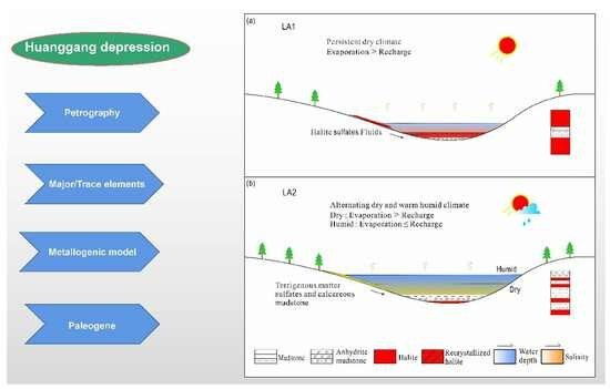
5.2. Depositional Models
6. Conclusions
Supplementary Materials
Author Contributions
Funding
Data Availability Statement
Acknowledgments
Conflicts of Interest
References
- Nutting, D.I. Orion of Bedded Salt Deposits: A Critique of Evaporative Models and Defense of a Hydrothermal Model. Ph.D. Thesis, Institute for Creation Research Graduate School, Santee, CA, USA, 1984. [Google Scholar]
- Schmalz, R.F. Deep water evaporate deposition: A genetic model. Ameriean Assoc. Pet. Geol. Bull. 1969, 53, 798–823. [Google Scholar]
- Last, W.M. Deep-water evaporite mineral formation in lakes of western Canada. Spec. Publ.—Soc. Econ. Paleontol. Mineral. 1994, 51–58. [Google Scholar]
- Manzi, V.; Lugli, S.; Lucchi, F.R.; Roveri, M. Deep-water clastic evaporites deposition in the Messinian Adriatic foredeep (northern Apennines, Italy): Did the Mediterranean ever dry out? Sedimentology 2005, 52, 875–902. [Google Scholar] [CrossRef]
- Meilijson, A.; Steinberg, J.; Hilgen, F.; Bialik, O.M.; Waldmann, N.D.; Makovsky, Y. Deep-basin evidence resolves a 50 year old debate and demonstrates synchronous onset of Messinian evaporite deposition in a non-desiccated Mediterranean. Geology 2018, 46, 243–246. [Google Scholar] [CrossRef]
- Sirota, I.; Enzel, Y.; Lensky, N.G. Halite focusing and amplification of salt layer thickness: From the Dead Sea to deep hypersaline basins. Geology 2018, 46, 851–854. [Google Scholar] [CrossRef]
- Aloisi, G.; Moneron, J.; Guibourdenche, L.; Camerlenghi, A.; Gavrieli, I.; Bardoux, G.; Agrinier, P.; Gvirztman, Z. Modes of deep basin halite accumulation during the Messinian Salinity Crisis. In Proceedings of the EGU General Assembly 2023, Vienna, Austria, 24–28 April 2023. No. EGU23-17206. [Google Scholar]
- Sirota, I.; Enzel, Y.; Mor, Z.; Ben Moshe, L.; Eyal, H.; Lowenstein, T.K.; Lensky, N.G. Sedimentology and stratigraphy of a modern halite sequence formed under Dead Sea level fall. Sedimentology 2021, 68, 1069–1090. [Google Scholar] [CrossRef]
- Hardie, L.A.; Eugster, H.P. The depositional environment of marine evaporites: A case for shallow, elastic accumulation. Sedimentology 1971, 16, 187–220. [Google Scholar] [CrossRef]
- Babel, M. Depositional environments of a salina-type evaporite basin recorded in the Badenian gypsum facies in the northern Carpathian Fore deep. Geol. Soc. Lond. Spec. Publ. 2007, 285, 107–142. [Google Scholar] [CrossRef]
- Yuan, J.; Huo, C.; Cai, K. The high mountain-deep basin saline environment a new genetic model of salt deposits. Geol. Rev. 1983, 29, 159–164. [Google Scholar]
- Zhang, P. Discussion Oil some geological problems of the research on Evaporite in China. Aeta Sedimentol. Sin. 1992, 10, 78–83. [Google Scholar]
- Zheng, M.P.; Chen, W.X.; Qi, W. New Findings and Perspective Analysis of Prospecting for Volcanic Sedimentary Boron Deposits in the Tibetan Plateau. Acta Geosci. Sin. 2016, 37, 407–418. [Google Scholar]
- Roveri, M.; Flecker, R.; Krijgsman, W.; Lofi, J.; Lugli, S.; Manzi, V.; Stoica, M.; Sierro, F.J.; Bertini, A.; Camerlenghi, A.; et al. The Messinian Salinity Crisis: Past and future of a great challenge for marine sciences. Mar. Geol. 2014, 352, 25–58. [Google Scholar] [CrossRef]
- Gao, H.; Chen, F.; Liu, G.; Liu, Z. Advance problems and prospect in studies of origin of salt rocks of the paleogene Shahejie formation in Dongpu Sag. J. Palaeogeogr. 2009, 11, 251–261. [Google Scholar]
- Jin, Q.; Huang, X. Studies on the origin of the Early Tertiary salt lake Dongpu depression: A postulated deep water model. J. Univ. Pet. China 1985, 10, 1–13. [Google Scholar]
- Gao, H.; Zheng, R.; Xiao, Y.; Meng, F.; Chen, F.; Bai, G.; Luan, Y.; Tan, X.; Shi, Y. Origin of the salt rock of Paleogene Shahejie Formation in Dongpu sag, Bohai Bay Basin: Evidences from sedimentology and geochemistry. Acta Pet. Sin. 2015, 36, 19–32. [Google Scholar]
- Yuan, J.; Zhao, C.; Zhang, S. Genetic model of the deep water salt lake of the Paleogene Sha-4 Member in Dongying sag. Acta Sedimentol. Sin. 2000, 18, 114–118. [Google Scholar]
- Wang, W.; Zhang, M. Study on deep water resedimented origin of saline sediments of E1 f4 in Zhaoji sag, Hongze depression, northern Jiangsu Basin. Acta Sedimentol. Sin. 2015, 33, 242–253. [Google Scholar]
- Li, C.; Guo, P.; Liu, C. Deposition models for the widespread Eocene bedded halite in China and their implications for hydrocarbon potential of salt-associated mudstones. Mar. Pet. Geol. 2021, 130, 105132. [Google Scholar] [CrossRef]
- Ji, Y.; Ren, H.; Zhang, S.; Ma, Z.; Niu, J.; Guo, S.; Gao, C.; Liu, X. Paleogene palaeogeography and oil and gas distribution in Bohai Bay Basin. J. Palaeogeogr. 2022, 24, 611–633. [Google Scholar]
- Tang, L.; Zhang, S.; Yu, X.; Tian, J.; Yang, B.; Luo, W.; Chen, W.; Liang, J.; Ma, X.; Wu, K. Geological characteristics and prospecting potentials of rock salt deposit in Huanggang Subdepression in southwest Shandong Province. Shandong Land Resour. 2021, 37, 1–10. [Google Scholar]
- Zhang, Z.; Zhang, C.; Wang, S.; Liu, S.; Wang, L.; Du, S.; Song, Z.; Zhang, S.; Yang, E.; Cheng, G.; et al. Views on classification and contrast of tectonic units in strata in Shandong Province. Shandong Land Resour. 2014, 30, 1–23. [Google Scholar]
- Liu, Q. Mesozoic and Cenozoic Terrigenous Clastic-Chemical Rock Salt Deposits in China; Beijing Science and Technology Press: Beijing, China, 1987; pp. 1–154. [Google Scholar]
- Zhu, G.; Jiang, D.; Zhang, B.; Chen, Y. Destruction of the eastern North China Craton in a backarc setting: Evidence from crustal deformation kinematics. Gondwana Res. 2012, 22, 86–103. [Google Scholar] [CrossRef]
- Zhao, T.; Zhu, G.; Xiang, B.; Lin, S.; Gu, C. Discussion on Initial Mechanism of the Tan-Lu Fault Zone. Acta Metall. Sin. 2016, 35, 1120–1140. [Google Scholar]
- Song, C.; Lv, D.; Chang, J.; Ejembi, J.I.; Tang, L.; Raji, M.; Chen, W.; Zhang, Z. Astronomically forced saline lake deposition and paleoclimatic response in the Huanggang Basin during the Paleogene, Eastern China. Ore Geol. Rev. 2023, 158, 105506. [Google Scholar] [CrossRef]
- Mjos, R.; Prestholm, E. The geometry and organization of fluviodeltaic channel sandstones in the Jurassic Saltwick Formation, Yorkshire, England. Sedimentology 1993, 40, 919–935. [Google Scholar] [CrossRef]
- Reading, H.G. (Ed.) Sedimentary Environments: Processes, Facies and Stratigraphy; John Wiley & Sons: Hoboken, NJ, USA, 2009. [Google Scholar]
- Miall, A.D. The Geology of Fluvial Deposits: Sedimentary Facies, Basin Analysis, and Petroleum Geology; Springer: Berlin/Heidelberg, Germany, 2013. [Google Scholar]
- Ortí, F.; Salvany, J.M. Coastal salina evaporites of the Triassic-Liassic boundary in the Iberian Peninsula: The Alacón borehole. Geol. Acta 2004, 2, 291–304. [Google Scholar]
- Ortí, F.; Rosell, L.; Anadón, P. Deep to shallow lacustrine evapo-rites in the Libros Gypsum (Southern Teruel Basin, Miocene, NE Spain): An occurrence of pelletal gypsum rhythmites. Sedimentology 2003, 50, 361–386. [Google Scholar] [CrossRef]
- Warren, J.K. Evaporites: A Geological Compendium, 2nd ed.; Springer: Cham, Switzerland, 2016. [Google Scholar]
- Garber, R.A.; Levy, Y.; Friedman, G.M. The sedimentology of the Dead Sea. Carbonates Evaporites 1987, 2, 43–57. [Google Scholar] [CrossRef]
- Roedder, E. Volume 12: Fluid inclusions. Mineral. Soc. Am. 1984, 12, 644. [Google Scholar]
- Handford, C. Halite depositional facies in a solar salt pond: A key to interpreting physical energy and water depth in ancient deposits? Geology 1990, 18, 691–694. [Google Scholar] [CrossRef]
- Zambito, J.J., IV; Benison, K.C. Extremely high temperatures and paleoclimate trends recorded in Permian ephemeral lake halite. Geology 2013, 41, 587–590. [Google Scholar] [CrossRef]
- Zhou, Z.; Dong, Q.; Hou, G.; Xu, C.; Miao, C. The forming environment and sedimentary evolution of the oil shale intergrowthing with salt alkali mine-with the oil shale deposit of Wucheng, Tongbai Basin as an example. J. Jilin Univ. (Earth Sci. Ed.) 2006, 36, 1001–1005. [Google Scholar]
- Eugster, H.P.; Surdam, R.C. Depositional environment of the Green River Formation of Wyoming: Apreliminaryreport. Geol. Soc. Am. Bull. 1973, 84, 1115–1120. [Google Scholar] [CrossRef]
- Cohen, P.A.; Macdonald, F.A.; Pruss, S.; Matys, E.; Bosak, T. Fossils of putative marine algae from the Cryogenian glacial interlude of Mongolia. Palaios 2015, 30, 238–247. [Google Scholar] [CrossRef]
- Warren, J.K. Evaporites through time: Tectonic, climatic and eustatic controls in marine and nonmarine deposits. Earth-Sci. Rev. 2010, 98, 217–268. [Google Scholar] [CrossRef]
- Bechtel, A.; Jia, J.; Strobl, S.A.; Sachsenhofer, R.F.; Liu, Z.; Gratzer, R.; Püttmann, W. Palaeoenvironmental conditions during deposition of the Upper Cretaceous oil shale sequences in the Songliao Basin (NE China): Implications from geochemical analysis. Org. Geochem. 2012, 46, 76–95. [Google Scholar] [CrossRef]
- Xu, Z.; Wang, Z.; Hu, S.; Zhu, S.; Jiang, Q. Paleoclimate During Depositional Period of the Upper Triassic Xujiahe Formation in Sichuan Basin. J. Palaeogeogr. 2010, 12, 415–424. [Google Scholar]
- Wang, K.; Luo, S. Geochemical characters of carbonates and indicative significance of sedimentary environment: An example from the Gaoyuzhuang formation of the Changcheng system in the northern Hebei Depression. Oil Gas Geol. 2009, 30, 343–349. [Google Scholar]
- Hu, M. Analyzing sedimentary environment using geochemical indicators—An example from north margin of Middle Yantze platform in Last Sinian. Pet. Explor. Dev. 1999, 26, 39–41. [Google Scholar]
- Song, C. Late Cenozoic Element Characters and Palaeoclimatic Change of the Lacustrine Sediments in Linxia Basin, China. Acta Sedimentol. Sin. 2007, 25, 409–416. [Google Scholar]
- Li, M.; Kang, S. Responses of lake sediments to palaeoenvironmental and palaeoclimatic changes in Tibetan Plateau. J. Salt Lake Res. 2007, 15, 63–72. [Google Scholar]
- Dill, H. Metallogenesis of early Paleozoic graptolite shales from the Graefenthal Horst (Northern Bavaria-Federal Republic of Germany). Econ. Geol. 1986, 81, 889–903. [Google Scholar] [CrossRef]
- Li, C.; Xiao, J. The application of trace element to the study on paleosalinities in Shahejie Formation of Dongying Basin Shengli oilfield. Acta Sedimentol. Sinca 1988, 6, 100–107. [Google Scholar]
- Hatch, J.R.; Leventhal, J.S. Relationship between inferred redox potential of the depositional environment and geochemistry of the Upper Pennsylvanian (Missourian) Stark Shale Member of the Dennis Limestone, Wabaunsee County, Kansas, USA. Chem. Geol. 1992, 99, 65–82. [Google Scholar] [CrossRef]
- Sun, Z. Sedimentary Environment and Oil and Gas Generation of Cenozoic Salt Lake in China; Petroleum Industry Press: Beijing, China, 1997; pp. 79–84. [Google Scholar]
- Zheng, R.; Liu, M. Study on palaeosalinity of chang6 oil reservoir set in Ordos basin. Oil Gas Geol. 1999, 20, 20–25. [Google Scholar]
- Shi, Z.; Chen, K.; Shi, J.; Liu, B.; He, H.; Liu, G. Feasibility analysis of the application of the ratio of Strontium to Barium on the identifying sedimentary environment. Fault-Block Oil Gas Field 2003, 10, 12–16. [Google Scholar]
- Song, M. Sedimentary environment geochemistry in the Shasi section of southern ramp, Dongying depression. Miner. Pet. 2005, 25, 67–73. [Google Scholar]
- Zhong, H.; Pu, R.; Yan, H.; Zhao, M.; Xu, J. Analysis on paleosalinity and paleoenvironment of Late Paleozoic in Tarim Basin. J. Northwest Univ. (Nat. Sci. Ed.) 2012, 42, 74–81. [Google Scholar]
- Wei, W.; Algeo, T.J. Elemental proxies for paleosalinity analysis of ancient shales and mudrocks. Geochim. Cosmochim. Acta 2020, 287, 341–366. [Google Scholar] [CrossRef]
- Dai, S.; Ren, D.; Zhou, Y.; Chou, C.; Wang, X.; Zhao, L.; Zhu, X. Mineralogy and geochemistry of a superhigh-organic-sulfur coal, Yanshan Coalfield, Yunnan, China: Evidence for a volcanic ash component and influence by submarine exhalation. Chem. Geol. 2008, 255, 182–194. [Google Scholar] [CrossRef]
- Fu, J.; Li, S.; Xu, L.; Niu, X. Paleo-sedimentary environmental restoration and its significance of Chang 7 Member of Triassic Yanchang Formation in Ordos Basin, NW China. Pet. Explor. Dev. 2018, 45, 998–1008. [Google Scholar] [CrossRef]
- Liu, P.; Zhou, H.; Kang, G. Distribution of elements and its relation with sedimentary environment in Songliao basin. Daqing Pet. Geol. Dev. 1986, 5, 11–15. [Google Scholar]
- Deng, H.; Qian, K. Sedimentary Geochemistry and Environment Analysis; Gansu Science and Technology Press: Lanzhou, China, 1993; pp. 95–104. [Google Scholar]
- Mao, X.; Zhou, L.; Yang, F.; Pu, L. Geochemical characteristics and its sedimentary environment significance of the Ordovician in the southwestern margin of Ordos basin. Geol. Sci. Technol. Inf. 2011, 30, 98–102. [Google Scholar]
- Fan, Y.; Qu, H.; Wang, H.; Yang, X.; Feng, Y. The application of trace elements analysis to identifying sedimentary media environment: A case study of Late Triassic strata in the middle part of western Ordos Basin. Geol. China 2012, 39, 382–389. [Google Scholar]
- Jin, M.; Li, W. Petrogeochemical characteristics of Lower Cretaceous and Pliocene rocks and paleoclimate evolution in Wulanhuaregion. Uranium Geol. 2003, 19, 349–354. [Google Scholar]
- Zhao, Z.Y.; Zhao, J.H.; Wang, H.J.; Liao, J.D.; Liu, C.M. Distribution characteristics and applications of trace elements in Junggar Basin. Nat. Gas Explor. Dev. 2007, 30, 30–33. [Google Scholar]
- Cao, J.; Wu, M.; Chen, Y.; Hu, K.; Bian, L.Z.; Wang, L.G.; Zhang, Y. Trace and rare earth element geochemistry of Jurassic mudstones in the northern Qaidam Basin, northwest China. Geochemistry 2012, 72, 245–252. [Google Scholar] [CrossRef]
- Fu, X.; Wang, J.; Chen, W.; Feng, X.; Wang, D.; Song, C.; Zeng, S. Elemental geochemistry of the early Jurassic black shales in the Qiangtang Basin, eastern Tethys: Constraints for palaeoenvironment conditions. Geol. J. 2016, 51, 443–454. [Google Scholar] [CrossRef]
- Wignall, P.B. Black Shales; Clarendon Press: Oxford, UK, 1994; p. 46. [Google Scholar]
- Xiong, G.; Wang, J.; Hu, R. Trace element characteristics and sedimentary environment of the Sinian system of the Fanjingshan area in Guizhou province. Acta Geosci. Sin. 2008, 29, 51. [Google Scholar]
- Rimmer, S.M. Geochemical paleoredox indicators in Devonian–Mississippian black shales, central Appalachian Basin (USA). Chem. Geol. 2004, 206, 373–391. [Google Scholar] [CrossRef]
- Jones, B.; Manning, D.A.C. Comparison of geochemical indices used for the interpretation of palaeoredox conditions in ancient mudstone. Chem. Geol. 1994, 111, 111–129. [Google Scholar] [CrossRef]
- Wignall, P.B.; Twitchett, R.J. Oceanic anoxia and the end Permian mass extinction. Science 1996, 272, 1155–1158. [Google Scholar] [CrossRef]
- Liu, A.; Li, X.; Wang, C.; Wei, K.; Wang, B. Analysis of geochemical feature and sediment environment for hydrocarbon source rocks of Cambrian in west Hunan-Hubei area. Acta Sedimentol. Sin. 2013, 31, 1122–1132. [Google Scholar]
- Cung, T.C.; Geissman, J.W. A review of the paleomagnetic data from Cretaceous to Lower Tertiary rocks from Vietnam, Indochina and South China, and their implications for Cenozoic tectonism in Vietnam and Adjacent areas. J. Geodyn. 2013, 69, 54–64. [Google Scholar] [CrossRef]
- Akhmetiev, M.A. Paleocene and Eocene floristic and climatic change in Russia and northern Kazakhstan. Bull. Geosci. 2010, 85, 77–94. [Google Scholar] [CrossRef]
- Chen, H.; Xie, X.; Van Rooij, D.; Vabdorpe, T.; Su, M.; Wang, D. Depositional characteristics and processes of alongslope currents related to a seamount on the northwestern margin of the Northwest Sub-Basin, South China Sea. Mar. Geol. 2014, 355, 36–53. [Google Scholar] [CrossRef]
- Quan, C.; Liu, Z.; Utescher, T.; Jin, J.; Shu, J.; Li, Y.; Liu, Y. Revisiting the Paleogene climate pattern of East Asia: A synthetic review. Earth-Sci. Rev. 2014, 139, 213–230. [Google Scholar] [CrossRef]
- Sun, X.; Wang, P. How old is the Asian monsoon system?—Palaeobotanical records from China. Palaeogeogr. Palaeoclimatol. Palaeoecol. 2005, 222, 181–222. [Google Scholar] [CrossRef]
- Zhu, M. Stuty on the origin of salt deposit in Dawenkou Basin in Shandong province. Shandong Land Resour. 2015, 31, 27–30. [Google Scholar]
- Chen, Y.; Wang, Y.; Guo, M.; Wu, H.; Li, J.; Wu, W.; Zhao, J. Differential enrichment mechanism of organic matters in the marine-continental transitional shale in northeastern Ordos Basin, China: Control of sedimentary environments. J. Nat. Gas Sci. Eng. 2020, 83, 1875–5100. [Google Scholar] [CrossRef]
- Liu, W.; Yao, J.; Tong, N.; Qiao, Y.; Chen, Y. Organic matter accumulation on the Dalong Formation (Upper Permian) in western Hubei, South China: Constraints from multiple geochemical proxies and pyrite morphology. Palaeogeogr. Palaeocl. 2019, 514, 677–689. [Google Scholar] [CrossRef]
- Ge, T.; Jiang, Z.; Kong, X.; Bao, H.; Chen, F.; Wu, S.; Guo, L.; Yang, Y.; Liu, T.; Zhang, J. Salt rhythmite formation and organic matter enrichment in the Qianjiang formation, Jianghan Basin, China: Constraints from alternating dry and wet climates. Mar. Pet. Geol. 2023, 148, 106067. [Google Scholar] [CrossRef]
- Bukowski, K.; Czapowski, G.; Karoli, S.; Bąbel, M. Sedimentology and geochemistry of the Middle Miocene (Badenian) salt-bearing succession from East Slovakian Basin (Zbudza Formation). In Evaporites Through Space and Time; Schreiber, B.C., Lugli, S., Bąbel, M., Eds.; Geological Society, Special Publications: London, UK, 2007; Volume 285, pp. 247–264. [Google Scholar]


| Lithofacies Type | Feature Description | Sedimentary Environment |
|---|---|---|
| Wave-parrel bedding fine-grained sandstone (FSwp) | Greenish-gray to brownish-gray, containing calcareous or argillaceous cement. Clay minerals as the base material, while the clastic composition mainly consists of well-sorted medium ellipse quartz and feldspar, with a small amount of mica. Plagioclase can be seen as polycrystalline twin, and potassium feldspar can be seen as lattice twin, with pore cementation (Figure 3a). | Fluid flow under low flow conditions, deposited in braided river or delta front mouth bar [28,29]. |
| Siltstone (S) | Purplish-red, containing thin mudstone and fine sandstone layers. The fine sandstone interlayers are generally sorted but with good roundness (Figure 3b). | Usually appears in alluvial fan depression, fan delta, or flood plain of fluvial deposit [30]. |
| Mudstone (M) | Gray–green or gray–black, mainly composed of argillaceous minerals, silty sand, organic matter, etc. Clay minerals are microscopically scaly or cryptocrystalline, with grain size generally less than 0.004 mm. The aggregates are slightly semi-oriented, forming a weak layered structure. Silty sand is mainly composed of feldspar and quartz fragments, which are mostly angular and distributed unevenly in gaps or bedding. Biological debris of Ostracoda, Lamellibranchia, and calcium globes can be seen occasionally (Figure 3c). | Formed in a stable water environment, such as a lakeside environment or a deep to semi-deep lacustrine environment [29], or in a flood plain, such as a sedimentary crevasse fan [30], or in an alluvial fan, a depression between the braided channels of a fan-delta plain, both during the humid climate [30]. |
| Interbedding with grey mudstone and anhydrite (M-A) | The mudstone is grayish-green or grayish-black, with a lamina thickness of 0.05~25 mm, and contains few felsic clasts, calcite, and pyrite. Illite is the dominant clay mineral distributed in scale-like direction. Angular-shaped feldspar clasts and heteromorphic granular-shaped calcite. Most anhydrite rocks are distributed in thin layers or banded layers, with thickness ranging from 0.2 to 20 mm. The anhydrite crystal is columnar, with a grain size of 0.02 to 0.8 mm (Figure 3d). | Mainly formed in the alternating environment of deep-lake evaporation and lake dilution [31]. |
| Gypsiferous mudstone (GpM) | Mainly consists of grayish-green mudstone. Massive anhydrite is produced in mudstone, in a thin or block-mass structure. The thin-block-mass gypsum layer has an irregular and massive internal structure, such as pores, small nodules or a broken and deformed internal clastic structure. Small crystal cores in the block are often surrounded by large gypsum crystals. The massive block gypsum is formed from the hemispherical or small-nodule-shaped consolidated gypsum, without intermediate lamination (Figure 3d,e). | Thin-layer block anhydrite is commonly found in shallow lake deposits, such as shallow salt lakes. Large-block anhydrite appears in shallow-lake environment, which is shallower than that of thin-block gypsum [32]. |
| Interbedding with carbonate and anhydrite (Aab) | Composed of irregularly alternating anhydrite layers (white) and carbonate layers (dark gray). Anhydrite mainly occurs in carbonate in the form of a strip, layer, and lens, and the thickness of laminae varies from 0.2 to 20 mm. Carbonate is in an argillaceous structure, mainly composed of calcite and dolomite, in a granular shape, with grain size less than 0.01 mm, mixed with a small amount of felsic clasts (Figure 3e,f). | The alternating light and dark laminated limestone represents the dynamic environment and flood events with seasonal strong/weak alternation, which mostly occur in deep-water deposits [33,34]. The rhythm of banded and lenticular gypsum alternates and the local water ripple marks indicate that the lenticular thin gypsum layer was formed in a deep-lake environment during the lake water dilution period [31]. |
| Halite (H) | Grayish-white or colorless, allomorphic or semi-idiomorphic grain. The grain size is about 2~10 mm. Grains are closely inlaid, with cubic cleavage developed for some particles, occasionally occurring as a ‘ladder’ structure. Contain terrigenous clasts, the mineral composition is mainly halite, with the thickness varying from 0.82 to 53.96 m. Primary fluid inclusions form a herringbone pattern in the chevron halite, as well as in the funnel-shaped cumulate halite (Figure 3g). | Herringbone crystal is a crystal–chemical feature of the growth of bottom halite up along the triple axis. When herringbone and funnel crystals appear at the same time, this indicates an extremely shallow water environment [35,36,37]. |
| Oil shale (OS) | Yellowish-brown, locally mixed with siltstone and mudstone, containing horizontal bedding, argillaceous texture, and foliation texture, with thickness almost always greater than 1 m, containing bioclastic. | Formed in the still-water environment of a semi-salty to salty shallow lake under a humid and hot climate. The highest dry–hot degree during the dry/wet alternation process at this stage has not reached the halite precipitation state [38]. |
| Purplish-red Argillaceous Siltstone (ASp) | Light red or purplish-red, porous cementation, consisting of quartz, feldspar, clay minerals, carbonate, and muddy particles. Angular-shaped detritus, with a grain size of 0.02~0.25 mm, mainly feldspathic clasts, little mica. The clay mineral of the base materials is mainly illite, microscopically scaly. The carbonate is mainly calcite, which is in an allomorphic granular shape, and the particle size is less than 0.05 mm (Figure 3h). | Usually appears in alluvial fan, fan delta, or fluvial deposits [31]. Generally, it is the product of turbidite sandy sediment mixed with deep-lake muddy sediment, which may be the result of periodic turbidite events [29]. |
| Number | Assemblages | Sedimentary Environment and Characteristics |
|---|---|---|
| FA1 | FSwp, M, S | Lakeside environment, with laminae at the bottom |
| FA2 | M, GpM | Deep to semi-deep lacustrine environment, commonly developed laminae |
| FA3 | M-A, Aab | Semi-deep to deep saline lacustrine environment, with laminae |
| FA4 | H, GpM, OS | Shallow saline lacustrine environment |
| FA5 | ASp, M, S | Fan delta (turbidity current deposits) without laminae |
| Depth(m) | Sample No. | Lithology | Trace Element Content | Main Element Content | ||||||||||||
|---|---|---|---|---|---|---|---|---|---|---|---|---|---|---|---|---|
| B (µg/g) | Ga (µg/g) | Sr (µg/g) | Ba (µg/g) | V (µg/g) | Ni (µg/g) | Cu (µg/g) | U (µg/g) | Th (µg/g) | MnO (%) | Al2O3 (%) | K2O (%) | TiO2 (%) | P2O5(%) | |||
| 902 | w26 | Mudstone | 31.98 | 13.55 | 201.20 | 795.60 | 44.74 | 17.81 | 16.68 | 0.82 | 7.08 | 0.0487 | 12.31 | 1.02 | 0.42 | 0.02 |
| 912 | w28 | Mudstone | 28.03 | 11.62 | 176.00 | 965.30 | 67.32 | 40.17 | 17.57 | 1.53 | 7.66 | 0.4094 | 8.54 | 1.06 | 0.37 | 0.05 |
| 922 | w30 | Mudstone | 55.26 | 18.69 | 600.60 | 1205.0 | 72.86 | 40.52 | 21.81 | 3.96 | 12.89 | 0.0777 | 13.40 | 2.22 | 0.52 | 0.08 |
| 927 | w32 | Mudstone | 23.42 | 10.25 | 175.20 | 701.80 | 33.39 | 11.09 | 9.80 | 1.98 | 6.63 | 0.1430 | 7.40 | 1.12 | 0.24 | 0.05 |
| 932 | w33 | Mudstone | 39.71 | 11.05 | 502.30 | 644.90 | 38.82 | 13.55 | 10.61 | 2.23 | 8.24 | 0.1183 | 8.57 | 1.57 | 0.33 | 0.11 |
| 942 | w35 | Mudstone | 46.22 | 12.89 | 598.10 | 427.30 | 47.81 | 16.70 | 12.95 | 3.26 | 9.11 | 0.0869 | 9.82 | 1.72 | 0.36 | 0.08 |
| 947 | w37 | Mudstone | 83.16 | 20.98 | 404.70 | 365.60 | 73.61 | 20.96 | 15.75 | 2.28 | 13.14 | 0.0602 | 15.09 | 2.77 | 0.53 | 0.11 |
| 952 | w38 | Mudstone | 72.24 | 17.59 | 653.50 | 256.10 | 66.70 | 25.76 | 20.19 | 4.16 | 12.30 | 0.0763 | 12.83 | 2.04 | 0.49 | 0.09 |
| 962 | w40 | Mudstone | 39.10 | 9.94 | 698.50 | 430.20 | 37.09 | 16.22 | 11.14 | 2.24 | 6.68 | 0.0669 | 6.88 | 1.38 | 0.25 | 0.10 |
| 967 | w41 | Mudstone | 35.08 | 9.27 | 794.30 | 355.20 | 32.46 | 14.35 | 9.52 | 1.57 | 5.99 | 0.0549 | 6.83 | 1.50 | 0.24 | 0.05 |
| 972 | w43 | Mudstone | 54.80 | 18.12 | 533.70 | 216.20 | 62.27 | 19.76 | 17.80 | 2.26 | 11.08 | 0.0516 | 13.25 | 2.65 | 0.40 | 0.12 |
| 982 | w45 | Mudstone | 69.18 | 15.94 | 561.50 | 444.80 | 59.25 | 21.52 | 17.14 | 3.21 | 11.33 | 0.0965 | 11.62 | 2.20 | 0.44 | 0.19 |
| 992 | w47 | Mudstone | 62.33 | 17.20 | 512.40 | 574.50 | 61.77 | 22.59 | 13.58 | 2.42 | 12.10 | 0.0613 | 12.94 | 2.46 | 0.48 | 0.15 |
| 1002 | w49 | Mudstone | 87.18 | 19.03 | 5158.0 | 987.30 | 69.21 | 22.03 | 19.62 | 3.71 | 13.02 | 0.0688 | 13.88 | 2.61 | 0.47 | 0.13 |
| 1012 | w51 | Mudstone | 65.84 | 24.78 | 851.00 | 403.60 | 90.01 | 25.46 | 19.42 | 2.79 | 14.64 | 0.0494 | 18.15 | 3.45 | 0.58 | 0.15 |
| 1022 | w53 | Mudstone | 73.03 | 15.46 | 1072.0 | 384.20 | 59.08 | 18.92 | 15.66 | 3.13 | 10.68 | 0.0646 | 11.39 | 2.18 | 0.39 | 0.11 |
| 1032 | w55 | Mudstone | 78.35 | 17.33 | 671.00 | 460.10 | 66.41 | 23.90 | 19.58 | 3.59 | 12.12 | 0.0694 | 12.84 | 2.86 | 0.49 | 0.12 |
| 1042 | w57 | Mudstone | 68.35 | 15.05 | 778.40 | 326.30 | 52.17 | 16.68 | 14.24 | 2.28 | 9.75 | 0.0464 | 10.98 | 2.43 | 0.37 | 0.11 |
| 1052 | w59 | Carbonate | 89.73 | 19.23 | 604.00 | 235.40 | 62.97 | 21.12 | 17.20 | 2.56 | 11.85 | 0.0419 | 14.05 | 2.94 | 0.41 | 0.15 |
| 1057 | w61 | Mudstone | 77.36 | 18.83 | 539.50 | 441.80 | 67.86 | 23.67 | 20.93 | 3.73 | 13.22 | 0.0659 | 13.29 | 2.66 | 0.50 | 0.08 |
| 1062 | w62 | Mudstone | 54.55 | 18.37 | 1127.0 | 384.10 | 72.81 | 27.23 | 23.79 | 4.01 | 13.29 | 0.0775 | 12.54 | 2.54 | 0.46 | 0.07 |
| 1072 | w64 | Mudstone | 95.78 | 20.28 | 318.30 | 346.80 | 74.49 | 23.58 | 24.13 | 2.99 | 13.78 | 0.0481 | 14.78 | 2.68 | 0.53 | 0.11 |
| 1082 | w66 | Mudstone | 29.74 | 6.58 | 807.00 | 177.00 | 22.37 | 9.48 | 6.77 | 0.94 | 3.83 | 0.0459 | 4.58 | 1.08 | 0.14 | 0.07 |
| 1092 | w68 | Carbonate | 28.32 | 6.18 | 869.30 | 204.10 | 23.92 | 11.05 | 6.45 | 1.40 | 4.11 | 0.0406 | 4.23 | 1.06 | 0.16 | 0.11 |
| 1102 | w70 | Mudstone | 64.40 | 15.95 | 1020.0 | 181.70 | 61.56 | 24.46 | 19.32 | 3.57 | 10.99 | 0.0675 | 11.59 | 2.04 | 0.42 | 0.09 |
| 1112 | w72 | Oil shale | 70.23 | 21.30 | 679.80 | 278.50 | 82.04 | 33.78 | 30.87 | 4.60 | 13.29 | 0.0851 | 14.20 | 2.54 | 0.51 | 0.11 |
| 1122 | w74 | Mudstone | 65.27 | 15.39 | 1373.0 | 504.90 | 56.35 | 20.97 | 16.70 | 3.90 | 12.31 | 0.0692 | 12.03 | 2.27 | 0.45 | 0.11 |
| 1132 | w76 | Mudstone | 89.52 | 16.62 | 1863.0 | 560.40 | 71.20 | 25.37 | 20.81 | 3.70 | 11.96 | 0.0749 | 12.37 | 2.32 | 0.48 | 0.21 |
| 1142 | w78 | Gypsiferous mudstone | 37.38 | 6.15 | 3950.0 | 366.60 | 23.57 | 9.41 | 7.50 | 1.26 | 4.35 | 0.0191 | 4.47 | 0.95 | 0.16 | 0.04 |
| 1152 | w80 | Gypsiferous mudstone | 11.64 | 1.98 | 1922.0 | 59.25 | 6.89 | 5.12 | 3.71 | 0.39 | 1.27 | 0.0068 | 1.26 | 0.29 | 0.05 | 0.02 |
| 1162 | w82 | Gypsiferous mudstone | 39.17 | 6.52 | 2073.0 | 164.40 | 25.30 | 10.21 | 7.83 | 1.57 | 4.76 | 0.0296 | 4.68 | 0.92 | 0.17 | 0.05 |
| 1172 | w84 | Oil shale | 35.97 | 12.42 | 1093.0 | 268.90 | 49.30 | 21.73 | 18.31 | 4.19 | 8.71 | 0.0688 | 8.72 | 1.61 | 0.30 | 0.14 |
| 1182 | w86 | Gypsiferous mudstone | 79.87 | 10.64 | 2410.0 | 433.80 | 38.30 | 13.74 | 11.51 | 2.69 | 8.01 | 0.0413 | 8.20 | 1.66 | 0.29 | 0.07 |
| 1192 | w88 | Gypsiferous mudstone | 86.83 | 10.38 | 2478.0 | 409.00 | 39.57 | 14.30 | 10.97 | 2.31 | 7.62 | 0.0569 | 7.66 | 1.50 | 0.27 | 0.08 |
| 1202 | w90 | Gypsiferous mudstone | 45.71 | 6.29 | 2139.0 | 520.90 | 26.40 | 9.58 | 6.79 | 1.41 | 4.17 | 0.0499 | 4.39 | 0.86 | 0.15 | 0.12 |
| 1212 | w92 | Gypsiferous mudstone | 17.17 | 2.60 | 2865.0 | 132.20 | 9.33 | 5.40 | 3.98 | 0.72 | 1.65 | 0.0190 | 1.73 | 0.37 | 0.06 | 0.03 |
| 1222 | w94 | Gypsiferous mudstone | 77.23 | 8.14 | 2883.0 | 254.40 | 30.02 | 12.19 | 9.78 | 2.06 | 5.94 | 0.0282 | 5.97 | 1.37 | 0.21 | 0.07 |
| 1232 | w96 | Halite | 1.20 | 0.46 | 199.00 | 5.88 | <0.3 | 0.61 | 0.41 | 0.06 | 0.06 | 0.0011 | 0.03 | 0.01 | 0.00 | 0.00 |
| 1242 | w98 | Halite | 17.56 | 2.58 | 4325.0 | 130.00 | 9.93 | 6.17 | 4.58 | 0.70 | 1.69 | 0.0091 | 1.86 | 0.46 | 0.06 | 0.03 |
| 1252 | w100 | Halite | 3.96 | 1.05 | 543.70 | 19.69 | 3.62 | 2.37 | 1.64 | 0.19 | 0.49 | 0.0100 | 0.50 | 0.14 | 0.02 | 0.02 |
| 1262 | w102 | Gypsiferous mudstone | 79.96 | 10.29 | 243.80 | 191.30 | 39.10 | 15.21 | 12.50 | 2.56 | 7.31 | 0.0574 | 7.58 | 1.65 | 0.26 | 0.09 |
| 1272 | w104 | Mudstone | 80.04 | 12.23 | 1418.0 | 537.40 | 45.62 | 16.28 | 13.06 | 2.57 | 8.63 | 0.0526 | 9.64 | 2.22 | 0.35 | 0.10 |
| 1282 | w106 | Halite | 2.84 | 0.79 | 692.40 | 20.28 | 2.23 | 1.67 | 1.29 | 0.14 | 0.36 | 0.0023 | 0.37 | 0.08 | 0.02 | 0.01 |
| 1292 | w108 | Halite | 3.28 | 0.78 | 36.76 | 10.08 | 2.24 | 1.33 | 1.20 | 0.15 | 0.28 | 0.0027 | 0.34 | 0.06 | 0.01 | 0.00 |
| 1302 | w110 | Mudstone | 75.99 | 10.33 | 1573.0 | 388.30 | 33.95 | 12.74 | 9.99 | 2.00 | 6.91 | 0.0367 | 8.35 | 2.08 | 0.28 | 0.07 |
| 1312 | w112 | Halite | 3.71 | 1.25 | 1349.0 | 43.67 | 3.47 | 3.15 | 2.41 | 0.28 | 0.68 | 0.0036 | 0.71 | 0.18 | 0.03 | 0.01 |
| 1317 | w113 | Halite | 1.69 | 0.43 | 179.10 | 7.03 | <0.3 | 0.83 | 0.63 | 0.14 | 0.07 | 0.0012 | 0.06 | 0.02 | 0.01 | 0.00 |
| 1322 | w115 | Mudstone | 54.18 | 6.15 | 623.30 | 248.60 | 23.31 | 9.98 | 6.90 | 1.33 | 4.29 | 0.0588 | 4.55 | 1.13 | 0.17 | 0.11 |
| 1332 | w117 | Halite | 1.41 | 0.37 | 1281.0 | 13.10 | <0.3 | 0.95 | 0.58 | 0.11 | 0.06 | 0.0012 | 0.04 | 0.01 | 0.01 | 0.00 |
| 1342 | w119 | Gypsiferous mudstone | 8.65 | 1.64 | 2468.0 | 53.71 | 5.02 | 3.34 | 2.29 | 0.32 | 0.82 | 0.0069 | 1.00 | 0.26 | 0.03 | 0.01 |
| 1352 | w121 | Halite and anhydrite | 10.38 | 2.74 | 1517.0 | 104.90 | 8.04 | 4.13 | 3.31 | 0.59 | 1.51 | 0.0076 | 1.97 | 0.54 | 0.06 | 0.02 |
| 1362 | w123 | Gypsiferous mudstone | 40.57 | 6.04 | 4418.0 | 244.90 | 20.78 | 9.89 | 8.12 | 1.51 | 4.08 | 0.0187 | 4.69 | 1.16 | 0.17 | 0.04 |
| 1372 | w125 | Halite and anhydrite | 124.64 | 11.86 | 3251.0 | 288.80 | 44.72 | 15.80 | 13.92 | 2.29 | 7.84 | 0.0469 | 8.86 | 2.26 | 0.28 | 0.09 |
| 1382 | w127 | Mudstone | 122.08 | 10.07 | 1796.0 | 358.40 | 42.87 | 16.12 | 16.22 | 2.96 | 7.55 | 0.0531 | 7.73 | 1.61 | 0.28 | 0.08 |
| 1392 | w129 | Mudstone | 127.78 | 13.32 | 568.00 | 252.30 | 49.12 | 25.90 | 23.41 | 3.11 | 9.92 | 0.0521 | 10.02 | 2.50 | 0.39 | 0.11 |
| 1402 | w131 | Gypsiferous mudstone | 48.35 | 7.74 | 765.30 | 391.10 | 22.98 | 9.13 | 6.93 | 1.33 | 4.76 | 0.0600 | 6.34 | 1.66 | 0.21 | 0.09 |
| 1412 | w133 | Gypsiferous mudstone | 211.90 | 16.01 | 262.50 | 387.70 | 55.98 | 24.51 | 20.66 | 2.67 | 12.39 | 0.0446 | 12.68 | 3.33 | 0.56 | 0.11 |
| 1422 | w135 | Halite | 6.78 | 1.11 | 703.20 | 31.43 | 2.86 | 1.77 | 1.33 | 0.24 | 0.59 | 0.0044 | 0.58 | 0.14 | 0.02 | 0.01 |
| 1432 | w137 | Oil shale | 23.16 | 7.68 | 280.20 | 504.90 | 14.22 | 7.01 | 4.71 | 1.35 | 4.25 | 0.0263 | 6.81 | 1.98 | 0.15 | 0.05 |
| 1442 | w139 | Halite | 1.02 | 0.45 | 1193.0 | 16.02 | 0.74 | 0.75 | 0.83 | 0.11 | 0.07 | 0.0025 | 0.02 | 0.01 | 0.00 | 0.00 |
| 1452 | w141 | Mudstone | 34.03 | 3.85 | 2677.0 | 141.70 | 13.18 | 7.29 | 5.48 | 0.81 | 2.48 | 0.0217 | 2.56 | 0.56 | 0.08 | 0.04 |
| 1462 | w143 | Mudstone | 44.51 | 3.40 | 3270.0 | 180.80 | 11.16 | 6.30 | 4.87 | 0.96 | 2.25 | 0.0211 | 2.33 | 0.54 | 0.08 | 0.02 |
| 1472 | w145 | Mudstone | 124.20 | 8.46 | 1633.0 | 235.50 | 26.94 | 9.92 | 9.34 | 1.59 | 5.34 | 0.0305 | 6.10 | 1.34 | 0.19 | 0.06 |
| 1482 | w147 | Carbonate | 25.58 | 2.54 | 2294.0 | 111.40 | 8.45 | 4.96 | 3.79 | 0.68 | 1.60 | 0.0195 | 1.81 | 0.39 | 0.06 | 0.02 |
| 1492 | w149 | Carbonate | 18.83 | 3.38 | 1861.0 | 133.30 | 10.90 | 5.93 | 4.14 | 0.84 | 2.04 | 0.0140 | 2.35 | 0.56 | 0.08 | 0.03 |
| 1502 | w151 | Halite | 46.06 | 4.66 | 2042.0 | 138.90 | 14.69 | 7.14 | 5.44 | 1.01 | 3.03 | 0.0241 | 3.33 | 0.74 | 0.11 | 0.03 |
| 1512 | w153 | Mudstone | 86.85 | 8.16 | 1228.0 | 173.20 | 32.10 | 13.16 | 10.57 | 1.88 | 5.60 | 0.0486 | 5.85 | 1.33 | 0.21 | 0.08 |
| 1522 | w155 | Mudstone | 106.24 | 9.79 | 2754.0 | 213.40 | 33.51 | 13.69 | 11.70 | 2.29 | 6.47 | 0.0284 | 7.16 | 1.46 | 0.23 | 0.05 |
| 1532 | w157 | Gypsiferous mudstone | 154.19 | 11.26 | 2527.0 | 330.50 | 43.18 | 16.48 | 13.89 | 3.32 | 7.69 | 0.0379 | 8.33 | 1.81 | 0.28 | 0.06 |
| 1542 | w159 | Mudstone | 33.34 | 3.94 | 1886.0 | 141.40 | 13.13 | 6.62 | 5.72 | 1.01 | 2.51 | 0.0188 | 2.74 | 0.68 | 0.09 | 0.03 |
| 1552 | w161 | Halite | 1.28 | 0.46 | 121.80 | 8.13 | <0.3 | 0.77 | 0.63 | 0.07 | 0.10 | 0.0009 | 0.05 | 0.02 | 0.01 | 0.00 |
| 1562 | w163 | Mudstone | 9.20 | 1.92 | 1937.0 | 29.18 | 5.49 | 4.60 | 3.22 | 0.35 | 1.08 | 0.0059 | 1.17 | 0.24 | 0.04 | 0.01 |
| 1572 | w165 | Halite and anhydrite | 91.94 | 11.08 | 1635.0 | 290.70 | 38.93 | 15.04 | 12.14 | 2.02 | 7.34 | 0.0278 | 8.24 | 1.75 | 0.29 | 0.05 |
| 1582 | w167 | Oil shale | 130.77 | 16.55 | 1037.0 | 484.80 | 58.63 | 22.21 | 20.02 | 3.71 | 11.50 | 0.0525 | 12.65 | 2.81 | 0.45 | 0.09 |
| 1592 | w169 | Gypsiferous mudstone | 116.96 | 8.16 | 2387.0 | 279.30 | 30.07 | 12.13 | 10.40 | 1.94 | 5.45 | 0.0308 | 5.96 | 1.22 | 0.20 | 0.05 |
| 1602 | w171 | Halite | 4.87 | 1.01 | 2130.0 | 40.57 | 2.52 | 2.68 | 1.84 | 0.22 | 0.45 | 0.0032 | 0.50 | 0.12 | 0.02 | 0.01 |
| 1612 | w173 | Oil shale | 31.33 | 4.45 | 1190.0 | 214.40 | 12.04 | 5.62 | 4.88 | 0.96 | 2.35 | 0.0159 | 3.52 | 0.84 | 0.10 | 0.03 |
| 1622 | w175 | Oil shale | 66.76 | 6.90 | 1197.0 | 303.80 | 19.50 | 8.36 | 7.03 | 1.38 | 4.71 | 0.0291 | 5.36 | 1.32 | 0.17 | 0.05 |
| 1632 | w177 | Gypsiferous mudstone | 93.52 | 9.64 | 2203.0 | 315.20 | 38.15 | 14.88 | 12.39 | 4.27 | 6.80 | 0.0566 | 7.13 | 1.41 | 0.23 | 0.08 |
| 1642 | w179 | Gypsiferous mudstone | 3.03 | 1.17 | 967.80 | 29.09 | 3.13 | 2.55 | 1.76 | 0.23 | 0.59 | 0.0063 | 0.64 | 0.14 | 0.02 | 0.01 |
| 1652 | w181 | Halite | 58.49 | 7.48 | 1343.0 | 252.10 | 23.78 | 9.71 | 8.44 | 1.76 | 5.07 | 0.0316 | 5.81 | 1.23 | 0.19 | 0.05 |
| 1662 | w183 | Halite | 3.05 | 0.92 | 182.30 | 19.49 | 1.70 | 1.27 | 1.21 | 0.18 | 0.32 | 0.0045 | 0.32 | 0.06 | 0.02 | 0.00 |
| 1672 | w185 | Gypsiferous mudstone | 37.38 | 5.22 | 2927.0 | 257.60 | 15.73 | 7.00 | 6.24 | 1.34 | 3.20 | 0.0224 | 3.74 | 0.85 | 0.12 | 0.04 |
| 1682 | w187 | Gypsiferous mudstone | 174.16 | 13.83 | 767.30 | 293.80 | 51.83 | 18.22 | 16.47 | 3.17 | 9.42 | 0.0692 | 10.53 | 2.19 | 0.35 | 0.08 |
| 1692 | w189 | Halite | 13.92 | 2.85 | 261.70 | 69.48 | 7.38 | 3.32 | 3.25 | 0.45 | 1.62 | 0.0116 | 1.82 | 0.36 | 0.07 | 0.02 |
| 1702 | w191 | Mudstone | 158.36 | 16.49 | 1318.0 | 458.80 | 58.40 | 21.46 | 20.12 | 3.50 | 10.58 | 0.0540 | 12.10 | 2.58 | 0.42 | 0.08 |
| 1707 | w193 | Mudstone | 10.96 | 1.70 | 3162.0 | 93.51 | 5.34 | 5.32 | 3.39 | 0.43 | 1.03 | 0.0051 | 1.01 | 0.24 | 0.04 | 0.01 |
| 1712 | w194 | Mudstone | 84.59 | 10.19 | 3066.0 | 309.70 | 34.56 | 14.51 | 12.01 | 2.58 | 7.05 | 0.0345 | 7.55 | 1.69 | 0.26 | 0.05 |
| 1722 | w196 | Mudstone | 5.12 | 0.99 | 1962.0 | 16.87 | 2.49 | 4.14 | 2.54 | 0.17 | 0.53 | 0.0023 | 0.48 | 0.10 | 0.02 | 0.01 |
| 1732 | w198 | Mudstone | 78.89 | 12.56 | 516.90 | 156.60 | 44.62 | 15.80 | 13.62 | 3.07 | 8.57 | 0.0640 | 9.49 | 1.87 | 0.32 | 0.11 |
| 1742 | w200 | Mudstone | 82.99 | 17.64 | 770.60 | 299.20 | 65.12 | 26.31 | 21.05 | 4.29 | 13.31 | 0.0721 | 13.12 | 2.56 | 0.48 | 0.08 |
| 1747 | w201 | Mudstone | 115.56 | 21.52 | 2884.0 | 526.80 | 84.59 | 28.90 | 27.33 | 4.15 | 14.06 | 0.0715 | 15.95 | 3.35 | 0.56 | 0.12 |
| 1752 | w211 | Argillaceous siltstone | 25.56 | 11.07 | 385.30 | 737.80 | 31.04 | 8.42 | 7.58 | 1.44 | 6.98 | 0.0559 | 10.76 | 2.56 | 0.36 | 0.11 |
| 1762 | w213 | Mudstone | 38.29 | 11.89 | 990.40 | 526.80 | 44.64 | 26.70 | 14.58 | 3.94 | 8.55 | 0.0988 | 9.63 | 2.12 | 0.38 | 0.17 |
| 1772 | w215 | Mudstone | 80.88 | 23.41 | 198.90 | 494.60 | 99.37 | 30.59 | 21.61 | 3.84 | 15.55 | 0.1082 | 17.21 | 3.58 | 0.68 | 0.20 |
| 1782 | w217 | Mudstone | 79.58 | 22.92 | 299.40 | 561.20 | 103.93 | 33.51 | 21.14 | 3.17 | 15.58 | 0.0982 | 17.28 | 3.65 | 0.66 | 0.13 |
| 1792 | w219 | Mudstone | 59.99 | 18.68 | 439.20 | 395.40 | 66.41 | 25.36 | 19.03 | 3.30 | 13.63 | 0.0825 | 13.68 | 2.88 | 0.57 | 0.14 |
| 1802 | w221 | Mudstone | 40.71 | 15.79 | 275.30 | 663.80 | 59.30 | 19.42 | 12.83 | 2.35 | 10.89 | 0.1120 | 12.56 | 2.72 | 0.50 | 0.12 |
| 1812 | w223 | Mudstone | 77.04 | 26.15 | 192.40 | 532.70 | 109.70 | 33.24 | 24.79 | 3.72 | 17.36 | 0.0672 | 19.41 | 3.59 | 0.74 | 0.11 |
| 1822 | w225 | Mudstone | 37.88 | 15.53 | 302.50 | 639.70 | 60.25 | 18.24 | 15.94 | 2.06 | 9.86 | 0.0858 | 12.43 | 2.71 | 0.47 | 0.12 |
| 1832 | w227 | Mudstone | 65.16 | 19.36 | 276.30 | 509.90 | 78.08 | 28.91 | 23.53 | 2.84 | 12.43 | 0.0334 | 15.50 | 3.26 | 0.54 | 0.07 |
| 1842 | w229 | Argillaceous siltstone | 65.83 | 19.26 | 276.30 | 691.40 | 77.54 | 25.98 | 15.95 | 3.11 | 14.30 | 0.0898 | 14.49 | 2.84 | 0.63 | 0.12 |
| 1852 | w231 | Carbonate | 1.19 | 0.64 | 1249.0 | 143.30 | <0.3 | 6.53 | 1.39 | 2.15 | 0.23 | 0.1530 | 8.97 | 2.15 | 0.23 | 0.06 |
| 1862 | w233 | Argillaceous siltstone | 74.61 | 25.81 | 175.10 | 503.20 | 99.76 | 31.13 | 24.64 | 4.05 | 17.80 | 0.0569 | 18.65 | 3.60 | 0.69 | 0.12 |
| 1872 | w235 | Mudstone | 74.96 | 27.93 | 124.60 | 315.60 | 127.97 | 34.30 | 52.55 | 3.37 | 16.83 | 0.0221 | 20.64 | 3.94 | 0.71 | 0.04 |
| 1882 | w237 | Mudstone | 59.80 | 21.24 | 393.50 | 417.30 | 87.59 | 32.19 | 21.35 | 3.73 | 15.23 | 0.0976 | 15.47 | 2.96 | 0.61 | 0.15 |
| 1892 | w239 | Mudstone | 46.56 | 17.24 | 266.00 | 706.00 | 68.06 | 23.77 | 21.87 | 2.82 | 11.97 | 0.1009 | 12.61 | 2.42 | 0.56 | 0.13 |
| 1902 | w241 | Argillaceous siltstone | 46.27 | 12.71 | 392.60 | 749.20 | 48.08 | 13.38 | 10.31 | 2.64 | 12.83 | 0.1110 | 11.00 | 2.33 | 0.55 | 0.16 |
| 1912 | w243 | Mudstone | 19.61 | 12.55 | 1325.0 | 710.20 | 54.59 | 17.18 | 14.84 | 4.99 | 8.69 | 0.1045 | 9.46 | 1.84 | 0.33 | 0.11 |
| 1922 | w245 | Argillaceous siltstone | 39.61 | 15.96 | 358.60 | 682.00 | 60.03 | 18.88 | 12.42 | 2.59 | 13.30 | 0.0886 | 12.65 | 2.50 | 0.53 | 0.15 |
| 1932 | w247 | Sandstone | 18.88 | 11.16 | 312.10 | 800.60 | 31.17 | 9.35 | 8.66 | 1.45 | 7.08 | 0.0870 | 10.44 | 2.43 | 0.32 | 0.10 |
| 1942 | w249 | Argillaceous siltstone | 34.71 | 16.57 | 272.50 | 697.10 | 57.48 | 19.72 | 13.14 | 3.48 | 11.52 | 0.0803 | 12.58 | 2.34 | 0.50 | 0.12 |
| 1952 | w251 | Sandstone | 13.34 | 10.39 | 464.70 | 677.30 | 24.78 | 8.13 | 5.81 | 1.21 | 5.74 | 0.0504 | 10.11 | 1.87 | 0.24 | 0.07 |
| 1962 | w253 | Mudstone | 36.62 | 17.50 | 413.90 | 817.20 | 70.85 | 22.82 | 31.50 | 2.60 | 12.53 | 0.0778 | 13.09 | 2.76 | 0.54 | 0.16 |
| 1972 | w255 | Mudstone | 52.62 | 10.71 | 734.10 | 321.70 | 41.55 | 14.68 | 11.76 | 2.46 | 7.63 | 0.0542 | 8.52 | 1.90 | 0.30 | 0.11 |
| 1982 | w257 | Mudstone | 45.28 | 14.99 | 304.70 | 350.00 | 55.85 | 17.62 | 12.64 | 2.51 | 11.18 | 0.1300 | 11.69 | 2.29 | 0.47 | 0.10 |
| 1992 | w259 | Mudstone | 39.95 | 20.70 | 207.30 | 576.40 | 84.01 | 30.18 | 22.40 | 2.65 | 14.07 | 0.0873 | 14.94 | 2.79 | 0.67 | 0.14 |
Disclaimer/Publisher’s Note: The statements, opinions and data contained in all publications are solely those of the individual author(s) and contributor(s) and not of MDPI and/or the editor(s). MDPI and/or the editor(s) disclaim responsibility for any injury to people or property resulting from any ideas, methods, instructions or products referred to in the content. |
© 2024 by the authors. Licensee MDPI, Basel, Switzerland. This article is an open access article distributed under the terms and conditions of the Creative Commons Attribution (CC BY) license (https://creativecommons.org/licenses/by/4.0/).
Share and Cite
Chen, W.; Lv, D.; Ejembi, J.I.; Yang, B.; Song, C.; Ning, Z.; Tang, L.; Zhang, Z.; Jia, H. Sedimentary Characteristics and Depositional Model of the Paleogene Dawenkou Formation in Eastern China: Insights from the Huanggang Depression. Minerals 2024, 14, 131. https://doi.org/10.3390/min14020131
Chen W, Lv D, Ejembi JI, Yang B, Song C, Ning Z, Tang L, Zhang Z, Jia H. Sedimentary Characteristics and Depositional Model of the Paleogene Dawenkou Formation in Eastern China: Insights from the Huanggang Depression. Minerals. 2024; 14(2):131. https://doi.org/10.3390/min14020131
Chicago/Turabian StyleChen, Wentao, Dawei Lv, John I. Ejembi, Bin Yang, Cuiyu Song, Zhenguo Ning, Lulu Tang, Zhihui Zhang, and Haibo Jia. 2024. "Sedimentary Characteristics and Depositional Model of the Paleogene Dawenkou Formation in Eastern China: Insights from the Huanggang Depression" Minerals 14, no. 2: 131. https://doi.org/10.3390/min14020131