
Natural Climate Protection through Peatland Rewetting: A Future for the Rathsbruch Peatland in Germany
by
 , ,
, ,
Petra Schneider
1,* ,
,
Tino Fauk
1,
Florin-Constantin Mihai
2,
Harald Junker
3,
Bernd Ettmer
1 and
Volker Lüderitz
1 1
Department Water, Environment, Civil Engineering and Safety, Magdeburg-Stendal University of Applied Sciences, Breitscheidstr. 2, D-39114 Magdeburg, Germany
2
CERNESIM Environmental Research Center, Institute of Interdisciplinary Research, Alexandru Ioan Cuza University of Iași, 700506 Iasi, Romania
3
Landkreis Wittenberg, Untere Naturschutzbehörde, Breitscheidstraße 3, D-06886 Lutherstadt Wittenberg, Germany
*
Author to whom correspondence should be addressed.
Land 2024, 13(5), 581; https://doi.org/10.3390/land13050581
Submission received: 31 January 2024
/
Revised: 18 April 2024
/
Accepted: 22 April 2024
/
Published: 27 April 2024
(This article belongs to the Special Issue Monitoring and Simulation of Wetland Ecological Processes)
Abstract
:Draining peatlands to create agricultural land has been the norm in Europe, but in the context of climate change and the loss of biodiversity, these rich ecosystems may reactivate their functions as greenhouse gas sinks and retreat spaces for animals and plants. Against this background, the National Moor Rewetting Strategy was put into effect in Germany in 2023, together with the Natural Climate Protection Action Plan. This article examines the methodology of peatland rewetting from scientific, administrative, social, and technical perspectives. The article focuses on an example of moor rewetting in central Germany: the Rathsbruch moor near the municipality of Zerbst, Saxony-Anhalt. To illustrate the importance of rewetting projects for degraded peatlands, five scenarios with different target soil water levels were considered, and the associated greenhouse gas emissions were calculated for a period of five years. For the planning solution, an estimate of the medium-to-long-term development of the habitat types was made based on current use and the dynamics typical of the habitat. The results for the Rathsbruch moor area showed that increasing the water level in steps of 1, 0.8, or 0.5 m has no significant influence on reducing the CO2 emissions situation, while a depth of 0.3 m has a slight influence. When the water was raised to 0.1 m below the surface (Scenario 5), a significant CO2 reduction was observed. The calculated avoided CO2 costs due to environmental damage show that the environmental benefits multiply with every decimeter of water level increase. The rising groundwater levels and extensification favor the establishment of local biotopes. This means that two of the biggest man-made problems (extinction of species and climate change) can be reduced. Therefore, this research is applicable to the development and planning of recultivation work at municipal and regional levels in Germany and beyond within the framework of EU restoration policy.
1. Introduction
The climate change pressure on natural habitats and human settlements is increasing, and future predictions reveal that, with political and community support, profound changes have to be made to current economic systems to avoid the worst-case scenarios [1]. Biodiversity loss is a critical threat, and preserving natural habitats, expanding protected areas, and restoring the degraded landscapes are crucial steps in biodiversity improvement. If the authors’ findings [2] are followed, it becomes evident that the current consumption of land and resources by humans, alongside the corresponding environmental changes, has a predominantly negative impact on biodiversity at all levels, ranging from genetic diversity to the biome. Reintroducing degraded lands into new green infrastructures for urban areas [3,4], or areas close to the natural state habitats, is supported by ecological engineering approaches to reduce the land consumption pressures of built-up environments.
Wetlands play a substantial role in protecting rich freshwater biodiversity; alongside their economic and recreational values [5], they serve as carbon storage areas and to provide a natural barrier for hazards such as floods, while they are polluted by surrounding industrial or agricultural activities. Previous studies show that rewetting peatlands around the world could reduce the GHGs emissions [6]. For example, a machine learning modeling study of a 74,000 ha rewetted area suggested that the rewetting process decreased the GHG emissions by 77 % compared to the same area when it was agricultural land [7]. Peatlands are one of the wetlands most affected by anthropogenic interventions, particularly in Europe. Therefore, a new peatland restoration strategy is required for Europe [8], supporting the regional biodiversity protection [9]. Around 15 % of global peatland emissions are generated in the EU [10]. In Germany, a peatland restoration strategy was put into force for state-owned properties in 2022 [11].
Peatlands are constantly waterlogged wetlands with a particularly characteristic, namely, low vegetation—above all, mosses, especially peat mosses, as well as sedges and often various dwarf shrubs—which forms predominantly acidic, nutrient-poor peat soils of at least 30 cm thickness due to incomplete decomposition [12]. Constant excess water from precipitation or from escaping mineral soil water keeps the soil low in oxygen and prevents the complete breakdown of plant residues, which are deposited as peat instead. This distinguishes them from swamps, which occasionally dry up, which is why their organic matter is completely broken down into humus on boggy soil. Living peatlands grow upwards through peat growth. In many European countries, near-natural peatland ecosystems have been largely destroyed by drainage measures and peat extraction and reduced to small residual areas. However, intact peatlands mitigate the effects of global warming by manipulating the water cycle in two ways. According to Ahmad, Liu, and Alam et al. [13], there is a connection between the meteorological influences, the groundwater level, and the latent heat flow. This comparison between a drained and a rewetted moor (same area) showed that on the one hand, the groundwater fluctuations were less pronounced; therefore, the daily evaporation for the rewetted moor could be increased by around 2.5 times. In addition, peatlands accumulate carbon in the anaerobic soil areas, which should be viewed as a measure to mitigate climate change.
A recent study has suggested that there is a lack of coherence in the EU policies related to peatlands from a multi-sectoral (water, agriculture, forestry, natural conservation) and multi-scale perspective, ranging from national to local levels [14]. However, restoration of peatlands requires a shift in the community paradigm from draining peatland practices, undertaken to produce more agricultural land in the past, to rewetting such areas for biodiversity protection and carbon storage areas in the present. To restore degraded peatlands and maintain a sustainable pathway, nearby community support is necessary. The inhabitants’ personal experiences of the nearby peatlands areas could drive pro-environmental behavior and the enactment of local climate actions [15]. Also, such sites could provide recreational value alongside their biodiversity conservation and carbon storages purposes [16]. Furthermore, the regional carbon markets seem to influence the business sector in providing timely actions in peatland restoration efforts [17]. On the other hand, the decarbonization economy could affect rural mono-industrial economies reliant on peat extraction, and sustainable low-carbon development alternatives must be proposed in such cases [18] to reduce the risks of conflicts between stakeholders in restoration activities [19]. The after-use of peat extraction sites through restoration (rewetting) or replacement approaches (afforestation, cultivation, creation of water bodies) requires an in-depth analysis, taking into account several factors such as biodiversity, climate, hydrology, ecosystem services, and socioeconomic implications, and most studies have failed to provide a such integrated assessment [20].
As drained peatlands contribute substantially to the release of long-term global warming CO2 emissions, as well as N2O emissions, the rewetting process of drained peatland areas used for forestry and peat extraction in Europe should not be further delayed [21,22]. For example, for European peatlands, the estimated annual mean N2O emission total was found to be 90.42 Gg N2O–N in 2020 [21]. Alongside the carbon emissions storage, the rewetting of peatlands attenuates the negative effects of drought [22,23]. Holistic economic modeling based on seven indicators suggests that the rewetting of drained peatland forest areas in Lithuania could recover the loss associated with the drainage process, which is estimated at EUR 307 million annually [24]. Therefore, forestry and agricultural activities in peatland areas must take into account the variety of ecosystem services provided by the restoration process, with support from both stakeholders and the community.
European peatlands restoration requires both technical and policy assistance to meet the environmental and climate-neutral ambitions promoted by EU. In this regard, Germany has a tradition of nature conservation [25] and the restoration of peatlands areas through rewetting [26] or replacement through paludiculture [27,28]. Therefore, this work reveals the restoration process of the Rathsbruch Peatland in Germany via the rewetting process, undertaking a multi-level analysis of the natural status of the peatland area (biodiversity, hydrology, and soil characteristics), as well as its technical requirements, administrative challenges, environmental benefits, and social implications.
2. Materials and Methods
2.1. Site Overview and Methodological Approach
The first drainage measures were carried out in the Vorfläming quarries as early as the 16th century. There was increased conversion of alluvial forests into meadows through the construction of narrow, shallow ditches. From 1850 to the 1970s, the ditch system was expanded, and drainage was installed. From 1973 to 1990, there was a complex amelioration. The drainage measures over the centuries have resulted in the Rathsbruch being a degraded bog. This project intends to restore the historic condition of the Rathsbruch, adapted to the current situation. The Rathsbruch is about 13 km east of Zerbst municipality in the district of Wittenberg, federal state Sachsen-Anhalt, in Germany (Figure 1). The following topics are addressed in the investigation strategy:
- Catchment characteristics of the Rathsbruch peatland;
- Biodiversity, soil, and hydrological status;
- Engineering solution for peatland rewetting (short term, midterm);
- Administrative requirements for project impact assessment;
- Greenhouse gas binding potential of the rewetted Rathsbruch Peatland;
- Social aspects of the planning process;
- Environmental management in the long term.
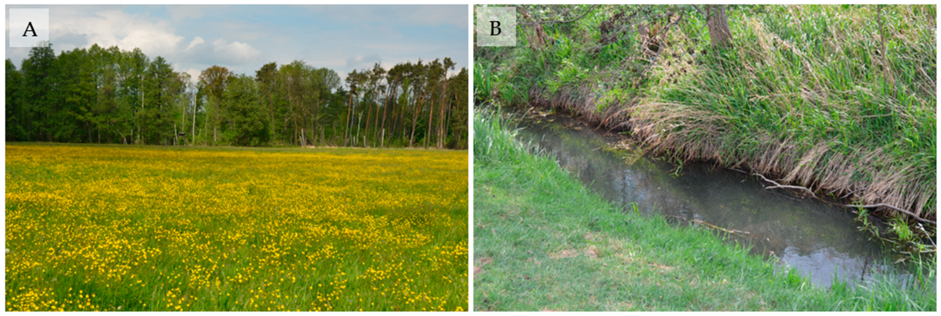
Figure 1.
Location of the Rathsbruch Peatland and the current land use and cover (LULC) of the investigated area. For the rewetted area, please refer to Figure 6A. For more details, refer to Figure 14A,B. Background map: OpenStreetMap Foundation (OSM); LULC map: based on DLM 50 [29] (rearrangement by Tino Fauk).

The area planned for rewetting is fully owned by Zerbst municipality, and the motivation for rewetting originates from the climate protection and environmental improvement goals of Zerbst municipality. It is important to mention that Zerbst municipality is the only owner of the properties to be rewetted, which facilitates project implementation. With a maximum extent of 1.7 km from north to south and 3.5 km from west to east, the study area has a specific plot of 2.89 km2. Figure 1 should be used as a guide.
2.2. Site Characteristics: Hydrology, Soil and Land Use
The Rathsbruch consists of a larger part of meadows and a smaller part of forest areas. Forestry usage interests on the part of the city do not exist or are being abandoned. The meadows are used agriculturally by three tenants and are used for the production of green fodder and for energetic use in biogas plants. In parts, grazing with cows is carried out. The nearby draining surface water body is called Boner Nuthe. The project area consists, in part, of the FFH protection area 0059 Obere Nuthe Läufe, which includes the Rathsbruch nature reserve. The Rathsbruch is also in the Roßlauer Vorfläming conservation area (LSG0076AZE). The FFH-protected region of Rathsbruch covers an area of 147.4 hectares. There are three biotope types with clear characteristics as priority biotopes. These include the Sub-Atlantic or Central European English Oak Forest (FFH code 9160), with an area of around 20.4 hectares, of which 97.5% is in moderate-to-poor condition. The oak mixed forests grow on loamy-to-sandy temporarily or permanently moist soils with higher groundwater levels or the influence of backwater [30]. The river valleys—low terraces as well as depressions, valleys, and lowlands—are populated. In successional developments, this forest type represents the final stage due to its longevity [30]. The impairment was classified as moderate or poor for all areas [31]. From a disturbing ecological point of view, the impairment of strong drainage should be mentioned.
The floodplain forest habitat type with Alnus glutinosa and Fraxinus excelsior (FFH code 91E0) covers around 22.4 hectares. The forests of FFH code 91E0 are growing in areas with episodic flooding and in areas where strong groundwater fluctuations are possible [32]. At these locations, the forest type is its final stage, which is characterized by rapid succession processes. Accordingly, regular renewal takes place. A total of 76.4% of the area have a moderate or poor structural expression, but the species inventory and the influence of disturbance are listed as at least good or low, which results in a rather positive initial situation for the overall assessment of the habitat results [31]. Only around 39.7% overall are in a medium or poor condition; the remaining areas are in good condition.
The mesophilic grassland (FFH code 6510) covers an area of 28.2 hectares and is generally characterized by extensive use and can therefore have species-rich populations (see Jäger et al. [33]). This habitat type is a so-called ecologically valuable secondary habitat. Without regular—even minor—human intervention, this type of habitat would not exist. All areas have at least a good level of structural diversity. Accordingly, as already mentioned, the distinctive species are only shown to be present on 60.6% of the area. Furthermore, according to Jäger et al. [33], the minimal expression follows as an association: Ranunculo repentis-Deschampsietum. This association is particularly common in compacted and drained peatland soils (see Figure 2A); the vast majority (85.8%) is in at-least-good condition. The assessment of the valued habitat types was based on LPR [31].
The remaining areas are predominantly mesophilic grassland that cannot be assigned to FFH area 6510. Other biotopes include mixed forest stands of the genera birch, oak, and alder, as well as pure stands of oak, pine, and larch. For rewetting, wet meadows, floodplain meadows, reed grass meadows, moist tall herbaceous meadows, etc., must be included. In addition to the FFH code 91E0, the alder forests must be listed. There are no assessments available for these habitats as they are not listed as priority habitats in the Natura 2000 area. The course of the Boner Nuthe is classified as habitat type 3260; rivers of the planar-to-montane level with vegetation of the Ranunculion fluitantis and the Callitrichio-Batrachion were identified by [31].
As part of the creation of the “Obere-Nuthe” management plan, the following species were mapped for the study area. It cannot be ruled out that other species worthy of protection are native to the adjacent areas. Species appearing in the FFH area “Obere Nuthe-Rivers” (FFH0059) that are listed in Appendix II of the Habitats Directive are [31] as follows:
Beaver (Castor fiber, Linnaeus);
European otter (Lutra lutra, Linnaeus);
Greater Mouse-eared bat (Myotis myotis, Borhausen);
Pug bat (Barbastella barbastellus, Schreber);
Herobuck (Cerambyx cerdo, Linnaeus);
Great crested newt (Triturus cristatus, Laurenti).
According to the measurement data of the German Weather Service DWD at the weather station Wittenberg, 30 km from the Rathsbruch, the precipitation amounts to an average of 570 mm per year in the last ten years. In terms of water balance, a discharge of around 39.6 L/s was determined for the Boner Nuthe, and a discharge of 3.4 L/s was determined for the Kleine Nuthe. Altogether, this results in a discharge of about 43 L/s and a discharge rate of 0.655 L/s*km2 in the project area.
The Kleinleitzkau groundwater measuring point (MKZ 40390010) is located in the vicinity of the project area. The weekly groundwater levels of the measuring point were available; these describe the groundwater level since 1974. While the water levels were still 170 cm below the measuring point between 1974 and 1980, the water level continued to drop significantly from 1980 onwards. In 2018, the groundwater level reached its lowest level since recording: almost 270 cm below the measuring point. This means a drop in groundwater of more than 1 m over 48 years.
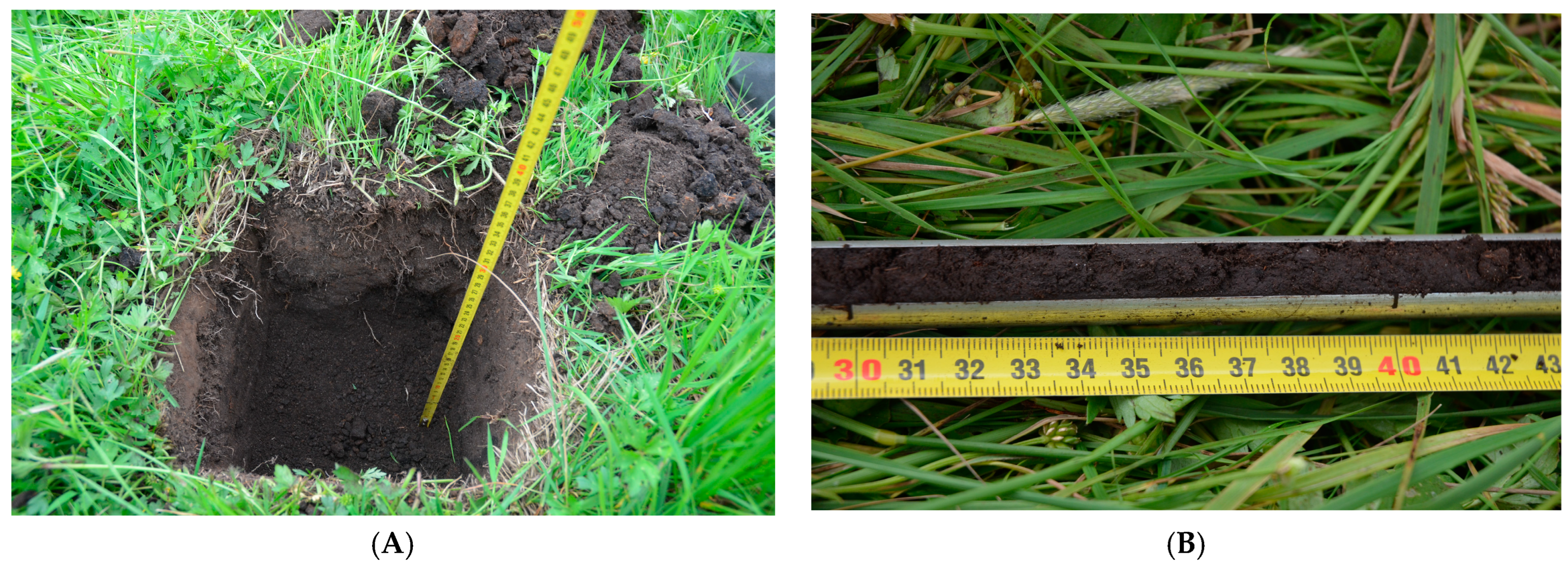
During the investigation of the project area, three soil samples were taken to determine the actual condition and composition of the soil. These soil samples are essential for hydrological calculations and determining the potential for rewetting and restoring a bog. The soil sampling was carried out with the help of a Pürckauer. With this type of drilling, the upper soil layer of approx. 1–1.5 m can be removed and evaluated as a whole. The trenches were dug with a spade. The boreholes examined provide an insight into the soil structure of up to 0.7 m. The investigation of 3 boreholes or trenches gives a rough overview of the soil properties in parts of the area.
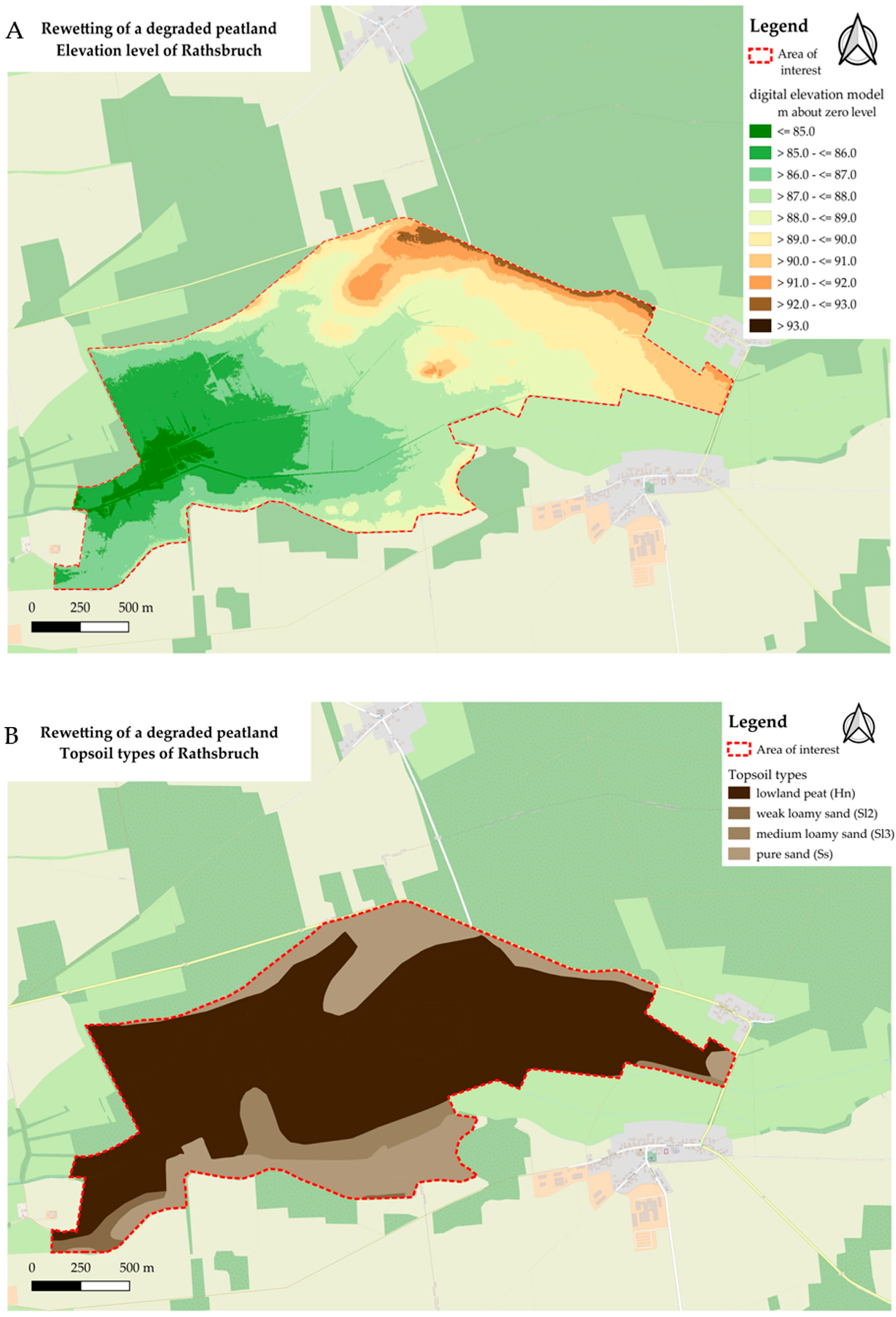
In the study area, most of the topsoil is characterized by lowland peat as visible in Figure 3. The remaining areas consist mainly of weak and medium loamy sands. These are replaced by pure sand at the elevations of the terrain. An overview of the different topsoil layers and the terrain structure is provided in Figure 3. In terms of the World Reference Base for Soil Resources (WRB, 2006) taxonomy, the investigated soils belong to the peats boggy degrading (mineralizing) (Fibric Histosols Dystric) type. The location of the degraded peats in the investigation area is illustrated in Figure 4B. Figure 4A shows the elevation level above zero, based on the digital terrain model, in order to identify water collecting zones.
2.3. Sampling of Macroinvertebrates and Fish
Macroinvertebrates (MI) were sampled in March and May 2022 in Boner Nuthe river along the river course in the investigation area (Figure 5A). The investigation covered two 100 m representative sections, one based on the future river relocation route and the other one near the town of Kleinleitzkau. We used an extended version of the multi-habitat sampling technique according to Lüderitz et al. [35] and Seidel et al. [36]. This technique considers all mineralic, organic, and mixed microhabitats. A total of 10 m2 at each site was sampled with a handnet (mesh size 0.5 mm). The individuals were fixed in ethyl alcohol (70%) and identified with keys reported by Lüderitz [35] up to the species level (except Diptera, identified up to the genus or family level). Easily identifiable species were already estimated in the field (Figure 5B).
The fish coenosis was detected via electrofishing in May 2022 by wading upstream on section lengths of 500 m. The instrument used was the Bretschneider electric fishing device EFGI 650 (1 anode, max. 650 W, 115 V). Fishing was conducted while wading upstream across the entire width. The fish were identified up to the species level and the length of the individuals was determined (+/−1 cm).
2.4. Assessment of the Ecological Status
The ecological status of the reaches was calculated via the present German standard assessment programs. All methods follow the approach whereby the present biocoenosis is set into relation with a given reference biocoenosis [37]. In principle, the difference between present and reference biocoenosis is evaluated as the ecological status. The ecological status for macroinvertebrates was calculated in Perlodes (www.gewaesser-bewertung-berechnung.de, accessed 20 June 2022). Based on autecological information and the present macroinvertebrate taxa list, the two modules—organic pollution and general degradation—are calculated, which, in turn, are calculated for the sand-dominated lowland stream from 1 and 3 metrics, respectively. For fishes, the program fiBS (www.gewaesser-bewertung-berechnung.de, accessed 20 June 2022) compares the present communities with the former historical reference fish community. The program calculates and compares six quality parameters, namely, composition, abundance and structure of species and guilds, age structure, migration, fish region, and species dominance [37].
2.5. Design Approach
The primary goal of this project is the rewetting of the Rathsbruch, which is directly linked to the restoration of the Boner Nuthe. Attached to the rewetting is the establishment of a natural forest and an area for extensive grazing.
Peatland: In the core area, peatland restoration is being sought, a process which can take decades. Peat soil can then actively store CO2 to a considerable extent. In the first phase of rewetting, the process of releasing CO2 from the peat soil is minimized and later reversed.
Natural forest: Zerbst municipality wants to forego the forest use of its forest areas adjacent to the peatland area. As part of the National Strategy on Biological Diversity [38], the federal government set the target in 2007 of taking 5% of the forest area out of forest use by 2020. This goal was missed. As a secondary effect of the peatland restoration, Zerbst municipality wants to make a contribution to achieving the 5% target.
Extensive grazing: The eastern part of the Rathsbruch is currently used for grazing by cows. This area is little or not at all affected by rewetting. There are plans to develop a grazing concept with the aim of continuing to enable or improve grazing and to decisively increase biodiversity in the areas.
As part of the planning for the rewetting of the Rathsbruch, investigations into the preliminary environmental impact assessment and FFH impact assessment were carried out for the favored planning variant.
2.6. Impact Assessment
2.6.1. Environmental Impact, Biodiversity, and Land Use Change
The effects of the ecological engineering measures on the existing habitat types have been simplified. The underlying ecological amplitudes of the expected plant or animal species (if known; otherwise, they were based on the genus) were used. Due to the extent of suitable modeling of food webs and/or resource availability, as well as competitive situations, only the relevant literature on habitat types and mapping as part of the FFH area designation were consulted and interpreted accordingly. The assessment and succession consequences, as well as the management and abiotic location factors of the priority habitats, can be found in the relevant literature (see [30,32,33]). However, the priority habitats are fundamentally divided into structural features, species inventory, and disturbances. Depending on the habitat type and federal state, other assessment matrices must be used. This becomes particularly clear when the plant geographical continentality levels are taken into account. Furthermore, investigations into the soil environment and its types were carried out in the form of soil maps and drillings, as well as the climatic and hydrological conditions used. Disturbance ecology includes both natural and (too often) human interference with natural balance. This was derived from conversations with local people and from the literature (based on [31]). Overall, this information has flowed together and represents the initial state. The change in abiotic conditions and the extensification of use (resource availability) serve as the basis for the simplified development forecast.
2.6.2. Estimating the Greenhouse Gas Emissions for Rewetting Szenario of Rathsbruch
In principle, CO2 emissions are higher in the aerobic organic soil environment than in the anaerobic areas [39,40]. Methane emissions from peat soils show a general dependence on the anaerobic areas (water level and soil moisture) [39,40]. Methane emissions from drainage ditches in drained peatlands can be as high as those from undrained peatlands [39]. This effect is caused by the dissolved organic compounds that accumulate in the drainage ditches [39]. Nitrous oxide emissions are influenced non-linearly by both the previous use (mineral fertilization or liquid manure) and the nitrogen inflows (grazing, surrounding land use) [39]. The results of Tiemeyer et al. [41] show a significant relationship between subsurface water level and GHG fluxes (carbon dioxide and methane; no relationship for nitrous oxide). We referred to the authors [41] and adopted the equations in openLCA. OpenLCA [42] is a free software for reproducing life cycle assessments. For consideration, a separate database has been created for modeling and future studies. For this purpose, the elementary flows included in the basic package of openLCA were used. It used a Tier 2 procedure, with some extensions to Tier 3 methods as defined in the IPCC Guidelines for National Greenhouse Gas Inventories [43]. For this highly simplified accounting of GHG, the limits of consideration were set to the change in use of the rewetted area and the change in management of the adjacent areas. For the rough estimate of the GHG balance, it is sufficient to consider the change in land use type “pastures and meadows” (IPCC category Grassland [43]). For this broader consideration, particularly of aboveground biomass, the approaches of Fauk and Schneider [44] are extended to the corresponding vegetation. For the purpose of measuring emissions resulting from land use change, this study only considers emissions from open land areas and organic soil, as well as the impact of rewetting on the GHG balance. Basically, the land use is composed according to Figure 1. The current land cover and use with the corresponding areas are represented in Table 1.
The identified areas for rewetting and management change are shown in Figure 6A. Figure 6B illustrates land uses impacted by an increase in groundwater, which are not considered in this study. These include forests (particularly mixed and deciduous forests), open bodies of water (such as rivers, ditches, and canals), and unpaved roads. While no significant changes in greenhouse gas emissions are expected for the open water bodies and the unpaved road (the water body has a constant extent; therefore, no changes in emissions are expected; and the unpaved road is too small; thus, there no noticeable effects (exclusion criterion)), the change in the forest areas is too uncertain without appropriate animal and plant physiological modeling. However, neither a statistically representative survey of the forest areas (density, age structure, etc.) nor further investigations of the beaver population (number, age structure, population vitality, etc.) were carried out as part of this study. Tree species occupy different ecological niches and therefore do not respond uniformly to abiotic and biotic changes in their habitat, which is reflected in different life spans or growth characteristics (see, e.g., Fauk and Schneider [44]). Due to the complexity of the matter, the accounting of forest areas is not considered.
The basic idea of land use change in this consideration is not to assign the current land use to a future new land use category, as is the usual process, but to map a change in management remaining in the current LULC category. Our concept of GHG fluxes associated with changing management and a rising water table based on natural carbon and nitrogen fluxes and current land use is shown in Figure 7.
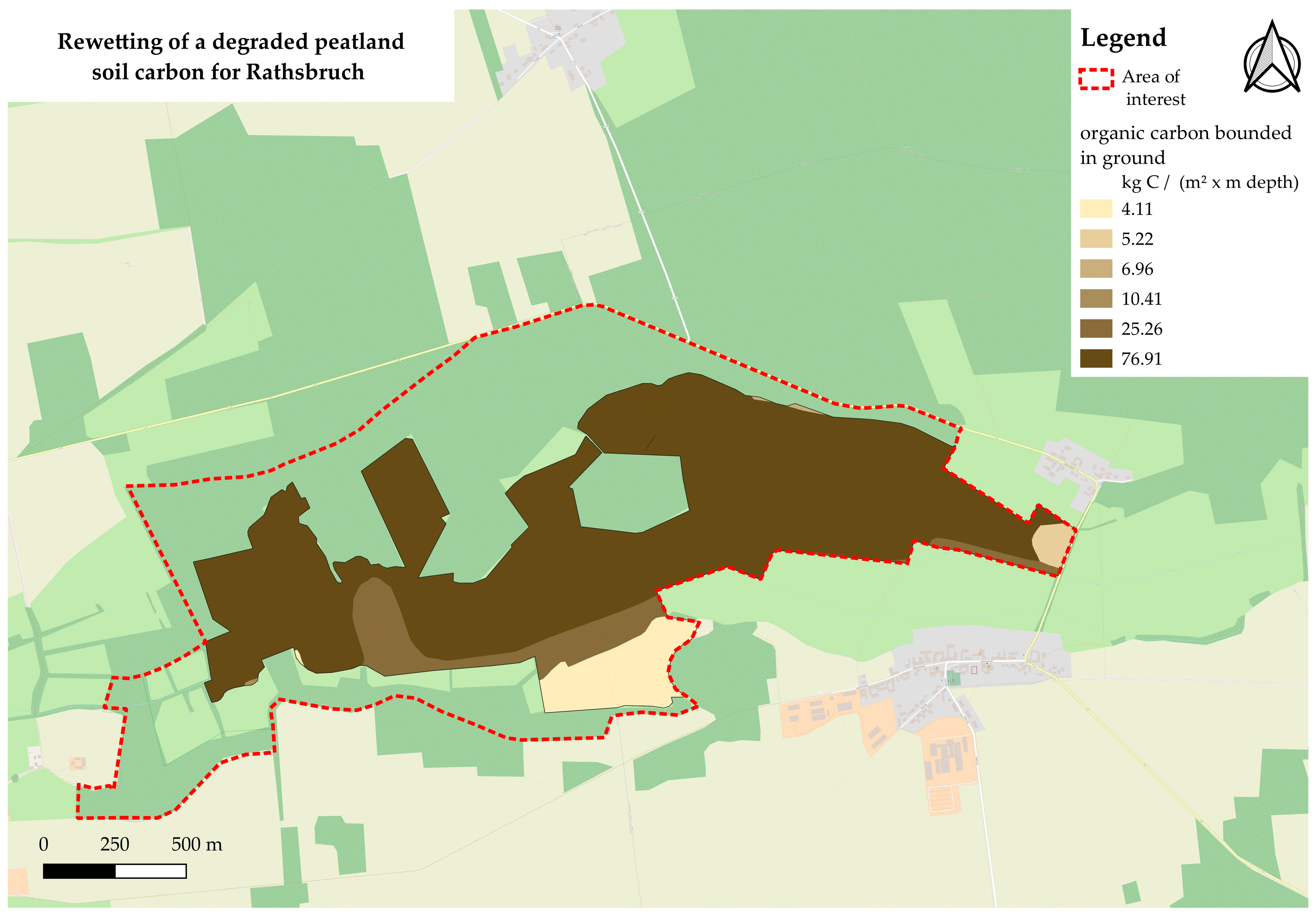
First, the excluded land use types (Figure 6B) were removed from the land use (Figure 1). The soil map (Figure 4B, soil type “lowland peat”) was then intersected with the remaining land uses. For this purpose, QGIS was used. The final outcome was the determination of the precise carbon content present in the soil. These data were produced in 2009 and a final refinement was reported in 2019 [34]. The organic carbon content of the soil for the corresponding life cycle assessment area for one meter depth is shown in Figure 8.
The previous map (Figure 8) served as the foundation for determining carbon availability for biological processes within the context of the natural carbon cycle. The initial sequestered carbon (76.91 Mg C per m2 × m depth) was used as an indicator for estimating carbon dioxide fluxes. As good practice, IPCC guidelines and national methodological refinements based on long-term studies were used for mineral soils. Therefore, no emissions or sequestration for mineral soils are given for Germany [45] (see Figure 8; all shapes < 76.91 kg C per m2 × m depth). The focus is on the GHG fluxes that are linked with the increase in soil water due to rewetting. Following the results presented by the authors of [41], indicating no significant impact of the soil water table on nitrous oxide fluxes, the estimated carbon flux affected by soil water (CO2-C(wt)) is restricted by the minimum carbon flux (CO2-Cmin), measured in Mg C per (ha × year). For these examples, a minimum carbon flux of 0 was assumed, which, in turn, should be interpreted to mean that no carbon sink will occur over the next six years. This assumption is based on the expectation of a longer transition phase for various vegetation structures, as discussed in Zerbe [46]. Nurse plants were not intentionally used and are unlikely to have a significant impact on achieving long-term stable populations and balanced biodiversity [46]. In German wetlands and drained organic soils, the upper limit for carbon (CO2-Cdiff) is reported to be 11.00 Mg C per (ha × year) [41]. Coefficients α (7.52) and β (12.97 m−1) were also provided in [41]. Wt refers to the water level from the surface in m; a value below zero indicates a water level below the surface, while a value above zero indicates the opposite. The carbon fluxes were calculated using Equation (1) [41].
CO2 − C(wt) = CO2 − Cmin + CO2 − Cdiff × exp(−α ∗ exp(β × wt))
The carbon dioxide mass (M(CO2)) (Equation (2)) is determined by multiplying the corresponding organic soil area’s soil water level (AorgS) with the carbon flux and accounting for the conversion of molar weight from carbon to carbon dioxide (44/12). As the carbon flux for a certain water level in a certain area has been determined for one year, this must now be summed over the areas considered. By multiplying the annual emissions by the period under consideration (in years), the absolute results are obtained under constant conditions.
M(CO2) = AorgS × CO2 − C(wt) ∗ 44/12
The annual methane flux, expressed as CH4(wt) and dependent on soil water table, is calculated using Equation (3) [41]. The minimum expected emission CH4min (both in kg CH4 per (ha × year)) and the soil water table (measured in meters) are presented. Coefficients γ (17,055) and δ (42.3 m−1) are applied [41].
CH4(wt) = CH4min + γ × exp(−δ × wt)
Like the determination of the carbon flux, methane emission (M(CH4)) is also determined in units of Mg CO2 eq. per (ha × a). However, the molar mass need not be utilized. For the equivalence calculation, the “IPCC 100a” impact estimation method was used. Additionally, methane has a GHG effect 27.75 times greater than that of carbon dioxide. Please see Equation (4) for reference.
M(CH4) = (AorgS × CH4(wt) × 27.75)/1000
Equation (4) is also naturally summed over the corresponding areas with organic soils and the corresponding water level.
To illustrate the importance of rewetting projects for degraded peatlands, five scenarios were selected that consider different soil water levels and associated GHG emissions over a five-year period. The area for rewetting in this study is to be put at about 67.18 ha (42.7% of the whole investigated area), of which 59.87 ha (89.1% of the “rewetting area”) is organic and 7.30 ha (10.9% of “rewetting area”) is mineral soil. The remaining area (“pasture and meadow”) comes to a total of about 90.13 ha (57.3% of the hole investigated area), of which about 71.54 ha (79.4% of the “pasture and meadow”) is organic soil and 18.59 ha (20.6% of “pasture and meadow”) is mineral soil. The respective conditions are shown in Table 2.
Ultimately, the accounting is completed using the approximated emissions for each scenario. By subtracting the reference scenario (S1) from the new scenarios (S2 to S5), the saving or intensification of GHG emissions (diff = Sn − S1) was determined. If the comparison is positive, a larger emission is the result; in the case of negative results, a saving is evident. A comprehensible error function was not available, so the IPCC standard error of ± 50% was used.
The value of ecosystem services and mitigated environmental damage—or, conversely, the cost of environmental damage caused by increased emissions—was determined based on the results presented by Matthey and Bünger [47], using carbon dioxide equivalents. It is assumed that future generations will be able to enjoy the same level of prosperity as the current generation. To derive the damage costs, the amount of social damage resulting from the emission of greenhouse gases and the corresponding climate change is estimated [47]. Since an emission that takes place in Germany, for example, affects the global climate, the “equity weighting” approach for western Europe was used [47]. This considers the different degrees of material well-being in the world. The nominal monetary value of the damage is weighted by the average income per inhabitant of the affected country. The damage costs caused by greenhouse gas emissions are essentially quantified by the increase in extreme weather events and sea level rise [48]. Damage is considered here, such as crop failures due to heavy rain or dry periods, along with repairs to buildings (only for wind and water damage, which can be directly attributed to climate change) and measures that serve to reduce damage, e.g., dikes, urban climate concepts, etc. Therefore, the cost of CO2 based on environmental damage was EUR 680 per ton in 2020 and EUR 700 in 2030 [47]. No market corrections were made to adjust for inflation. After the interpolation of prices, the cost of environmental damage is to be set at EUR 686 per ton in 2023.
3. Results
3.1. Catchment Characteristics of the Rathsbruch Peatland
The results of the drillings can be summarized as follows:
Drilling 1 and dig 1 (Figure 9):
- 0–20 cm below surface (BS): fine sand, medium sandy, slightly coarse sandy, slightly silty, organic components, decomposed, black-brown.
- 20–35 cm BS: fine sand, medium sandy, slightly coarse sandy, slightly silty, organic components, decomposed, black-brown.
- 35–42 cm BS: silt, clayey, strongly organic, black, final depth 42 cm BS.
Figure 9.
Impressions of (A) dig 1 and (B) drilling 1 (photo credit: Petra Schneider).

Drilling 2 and dig 2 (Figure 10):
- 0–25 cm BS: fine sand, medium sandy, slightly silty, organic components, decomposed, black-brown.
- 25–65 cm BS: silt, clayey, strongly organic, black, final depth 65 cm BS.
Figure 10.
Impressions of (A) dig 2 and (B) drilling 2 (photo credit: Petra Schneider).

Drilling 3 and dig 3 (Figure 11):
- 0–20 cm BS: fine sand, medium sandy, silty, organic components, decomposed, black-brown.
- 20–65 cm BS: silt, clayey, strongly organic, black.
- 65–66 cm BS: Coarse sand, fine sand, final depth 66 cm BS.
Figure 11.
Impressions of (A) dig 3 and (B) drilling 3 (photo credit: Petra Schneider).

The investigation results show that the peatland body is partially and locally degraded. The catchment characteristics of the Rathsbruch peatland showed that the degradation in the Rathsbruch area is already advanced, leading to a situation whereby the original peatland cannot any longer be fully restored. However, there is potential for ecological improvement to initiate the new formation of peatlands.
3.2. Ecosystems Assessment Results
3.2.1. Evaluation by means of Macroinvertebrate
The overall assessment results from the respective individual modules are presented in this section. This describes the condition class for each measuring point based on the individual evaluation, with the worst value as the relevant module. The final results are listed in Table 3. In the rewetting area, the course of the stream is degraded to a high degree, ecological status is bad, and species number is low. The poor result means that the Boner Nuthe needs to take action in accordance with the WFD for the upper section. Due to its good ecological status, there is no need for action in accordance with the WFD for the lower stretch of water.
3.2.2. Evaluation by Means of Fish
The overall assessment of the six relevant quality characteristics suggests a poor ecological scenario, with a rating of 1.47 on a three-class scale of 1–5 and of 0.12 on a standardized scale of 0–1. This result is described in detail below to provide an overview of the reasons for the “poor ecological status”. The sampling results also show a deficit in the anadromous and potamodromous species, which indicates a deficit in the longitudinal continuity of the water body. The assessment result is limited by the total number of determined individuals. The minimum number of individuals is many times below the recommended guideline value, which is why the probability of an incorrect assessment of the ecological status is high. Nevertheless, the fish-based assessment results are presented in Table 4.
3.3. Restoration of the Boner Nuthe for Peatland Rewetting and Good Ecological Status of the Water Body: Rewetting Design Solution
This project included the redesign of the course of the Boner Nuthe and the installation of ground sills in the small Nuthe (Figure 12). Thus, the Boner Nuthe, which shows a historical course, is brought back into line with its original kind of meandering. This makes it possible to create a near-natural state. The hydromorphology of the water body also fits back into the model-typical structure with typical habitats. The associated water level rising has a positive effect on the drainage capacity of Boner Nuthe. The groundwater level can be raised in this way.
Conceptual planning started in 2022. The aim was to limit rewetting to the property areas owned by Zerbst municipality only. This will be achieved by an already existing ditch in the western part of the Rathsbruch, which directs the water into the Boner Nuthe before areas further west can become waterlogged. The terrain in the Rathsbruch rises to the north and south (approx. 85 NHN in the middle and 88–89 NHN at the edges). An extension of the waterlogging to the north and south is therefore not to be expected. The rewetting methodology consists of the following sub-measures: Existing beaver dams should make a significant contribution to rewetting; due to the activity of beavers in the area, there is already waterlogging in some areas, which is mostly limited to the autumn and winter months. The existing drainage ditches in the area are chambered so that the water stays in the area (Figure 12). Rows of wooden poles are placed in the Kleine Nuthe. This barrier allows the sediments to settle better on the bed and slowly raise the bottom level.
The course of the Boner Nuthe will be relocated—based on the historical course—before the straightening. The new course of the Boner Nuthe cuts slightly into the landscape, which allows for a close connection between the body of water and its surroundings. As a result, the river bottom will be about 25 cm below ground level in the future, which means that the mean water level will be about 10 cm below ground level. Compared to the current state, this results in reduced drainage to the adjacent peatland areas. The lengthening of the course by around 500 m also reduced the gradient of the Boner Nuthe, which means that the water stays in the area for a longer period of time. This counteracts drainage of the area through the current course of the Boner Nuthe, which cuts deep into the terrain and has been straightened. According to hydrological calculations, an adverse hydrological effect on the surrounding areas is not to be expected.
The design included the relocation of the riverbed in order to direct the water into the peatland area. Moreover, the activity of beavers shall be supported; they are known as nature engineers. The impact assessment refers mainly to biodiversity as the Rathsbruch peatland is located in a Fauna–Flora–Habitat area. Public participation was already performed in October 2022 by way of public presentation and consultation. Around 30 citizens participated and strongly discussed the relevant issues.
3.4. Impact Assessment
3.4.1. Environmental Impact Assessment
Various protected areas are affected by the project, namely, the landscape protection area Roßlauer Vorfläming (LSG0076AZE) as well as adjacent West Fläming (LSG0068AZE) and Zerbst Naturtäler (LSG0077AZE). No adverse effects are expected on the protected areas, including the Rathsbruch nature reserve (NSG0093). The drainage severely endangers the preservation of the protection goals, which are to maintain near-natural wet forest communities with their typical species richness and to serve as a link in the system of the lowland protection area. Conversely, rewetting promotes the protection goal of the NSG by regulating the amplitudes of groundwater level changes. The FFH area “Obere Nuthe-Läufe” (FFH0059) is affected by the restoration as the ecological status of the habitat types (Lebensraumtyp LRT) will be changed. During the construction phase, environmental factors in the project area may be impaired. However, these are temporary and can be minimized by undertaking various measures.
Impact on landscape: The landscape in the Rathsbruch will be significantly changed in the long term as a result of the planned groundwater elevation in the area. While habitat type LRT 6510—lean lowland hay meadows—currently dominates, over time, an alder swamp forest of LRT 91E0* will develop. The new structure-rich course of the Boner Nuthe will replace the structure-poor water course and upgrade the landscape.
Impact on humans: There is no residential development in the project area. There may be a temporary odor nuisance from methane emissions, and the mosquito population could also increase. The balanced microclimate and the cooling effect of peatland in the summer will have a positive effect.
Impact on plants, animals, and biological diversity as protected goods: The rewetting will be accompanied by the loss of areas of LRT 6510 (lean lowland hay meadows), which will be replaced by alder swamp forest and partly by floodplain forest LRT 91E0* and sub-Atlantic or central European English oak or hornbeam–oak gorest LRT 9160. This restores the natural state.
Impact on climate and air: A higher soil moisture, which results from the longer residence time of the water in the area, offers the vegetation the potential to achieve higher transpiration, and on the other hand, the upper centimeters of the soil layer have sufficient moisture, so continuous evaporative cooling can also be assumed here (see [13]). The effects on habitats described in the following chapter also affect the carbon sink function.
Impact on soil and land: It can be expected that soil functions will be upgraded in the long term. The carbon stored by sedges and reeds initially accumulates in the anaerobic areas; in the subsequent stages, enrichment in the form of wood-bound carbon (e.g., alder forest) can be assumed. This process promotes carbon accumulation in the soil compartment. As a result of the planned measures, a strong organic soil will develop in the project area again in the long term.
Impact on water: A positive change in the body of water can be expected as a result of the near-natural redesign of the Boner Nuthe watercourse. A strengthening of the groundwater formation is to be expected, and the water balance will be returned to a natural state.
3.4.2. Fauna–Flora–Habitats (FFH) Impact Assessment
The impact assessment is performed according to the requirements of the EU Fauna–Flora–Habitats Directive (FFH-D), as the project area is located in the FFH area “Obere Nuthe-Rivers” (FFH0059). The principal conservation objective is to ensure the long-term favorable conservation status of the habitat types and species of community interest. The objects of protection are the reported habitat types (LRT) of Annex I and their characteristic species, as well as the species of Annex II of the FFH-D.
The planned increase in groundwater in the area will significantly change the landscape in Rathsbruch in the long term. Currently, the habitat types of LRT 6510—poor lowland hay meadows—and mesophilic grassland predominate in the rewetting area. The lack of management in areas with higher and less-fluctuating groundwater levels is initially determined by the natural dynamics of this habitat type. According to Jäger [33], rapid changes in species composition can occur after even short-term changes in management or abiotic conditions. Due to the occurrence of sedges and reeds in the flood area and the proximity to the LRT 6510 and the mesophilic grassland, an area dominated by Carex species and Phragmites australis will initially form. Depending on the nutrient supply, this will be more or less quickly covered with bushes or trees [33]. Slower tree succession is to be expected on nitrogen-rich sites [33]. First, short-lived tree species will settle, as suggested by the mixed stands of birch trees in the adjacent areas. The already-existing alder forests will also be able to quickly establish themselves on organic soils and very wet sites. While alder dominates the quarry forest on nutrient-rich sites, birch dominance develops on nutrient-poor sites [49,50]. The alder forest is a mosaic of open land, dead wood, and areas mainly covered with alder. Due to the lower groundwater fluctuations, it can be assumed that the LRT 91E0 will be pushed back slightly from the area but will show a tendency to spread along the new course of the Boner Nuthe [32]. In areas with mineral substrates and flooded areas, as well as permanently high groundwater levels, the LRT 9160 can be viewed as the final stage of succession [30]. An overview of the expected developments of the biotope types in the rewetting area, based on the abiotic conditions and the ecological potential, can be found in Figure 13.
There is no evidence of all of the species mentioned in the project area. When it comes to fish, the greatest risk potential lies in maintaining current conditions. This will be counteracted primarily by creating a new course of the Boner Nuthe river, which will substantially improve the water system.
For mammals, drying out due to the current water regime can have negative effects on the habitat, which is intended to be improved by raising the groundwater. The potential threat to insects also lies primarily in the maintenance of the hydrological regime and the loss of certain trees as habitats due to drought stress. Apart from the spadefoot toad, the greatest impact on amphibians will also result from the maintenance of the existing hydrological setting. The area planning envisages, on the one hand, the rewetting of a sub-area, an on the other hand, the extensification of use. This is necessary to ensure the protection goals of insect protection in the Rathsbruch area. In addition, current overuse is counteracted. The over-fertilization described by locals and the associated loss of species richness [31] is prevented by designating new areas. Any seed transfer from a donor area in the immediate vicinity should be sought, and at the same time, good management must be pursued in order to maintain the surrounding genetic diversity. It can be assumed that mowing will initially have to be conducted more frequently to remove excess nutrients. However, the mowing time must be tailored to the relevant target species (after flowering). Incorrect management would quickly lead to bottle depletion.
The rewetted areas can be used for bird protection in the first 10 to 20 years, but also permanently in suitable locations (environmental constructions by beavers or structures based on the alder swamp). Initially, smaller trees and tall perennial areas with at least moist-to-wet soils can be expected. These areas are comparable to the sedge and reed populations currently used. These open areas provide breeding and feeding habitats for, for example, Grus grus (see Appendix Figure A1A), and dragonfly species can also benefit from the structurally rich habitats with open water areas (see Appendix Figure A1B), while species that, for example, rely predominantly on sweet grasses and more dry habitats can switch to extensive pasture areas (see Appendix Figure A1C). The final phase then becomes a mosaic of open spaces, waterlogged areas, particularly near the beaver’s main food sources, and different age structures of the woody plants. Soft types of wood in particular are used to build beaver dams and as a source of food (bark, young wood). This leads to an open area and the presence of appropriate types of wood. Appendix Figure A1D gives an impression of such a mosaic of open land and tree-lined floodplains. An improvement in the structure of the LRT 9160 and the expansion of the sandy, loamy areas favors the spread and preservation of the population of Cerambyx cerdo. This can occur due to the synergy effects between the expansion of floodplain trees (e.g., alder), the beaver population, and the great crested newt population. The two bat species found in the immediate study area (the pug bat and the greater mouse-eared bat) also benefit from natural succession. The new structure-rich course of the Boner Nuthe will replace the structure-poor watercourse and round off the landscape as a whole.
3.4.3. Impact Assessment on Greenhouse Gas Emissions
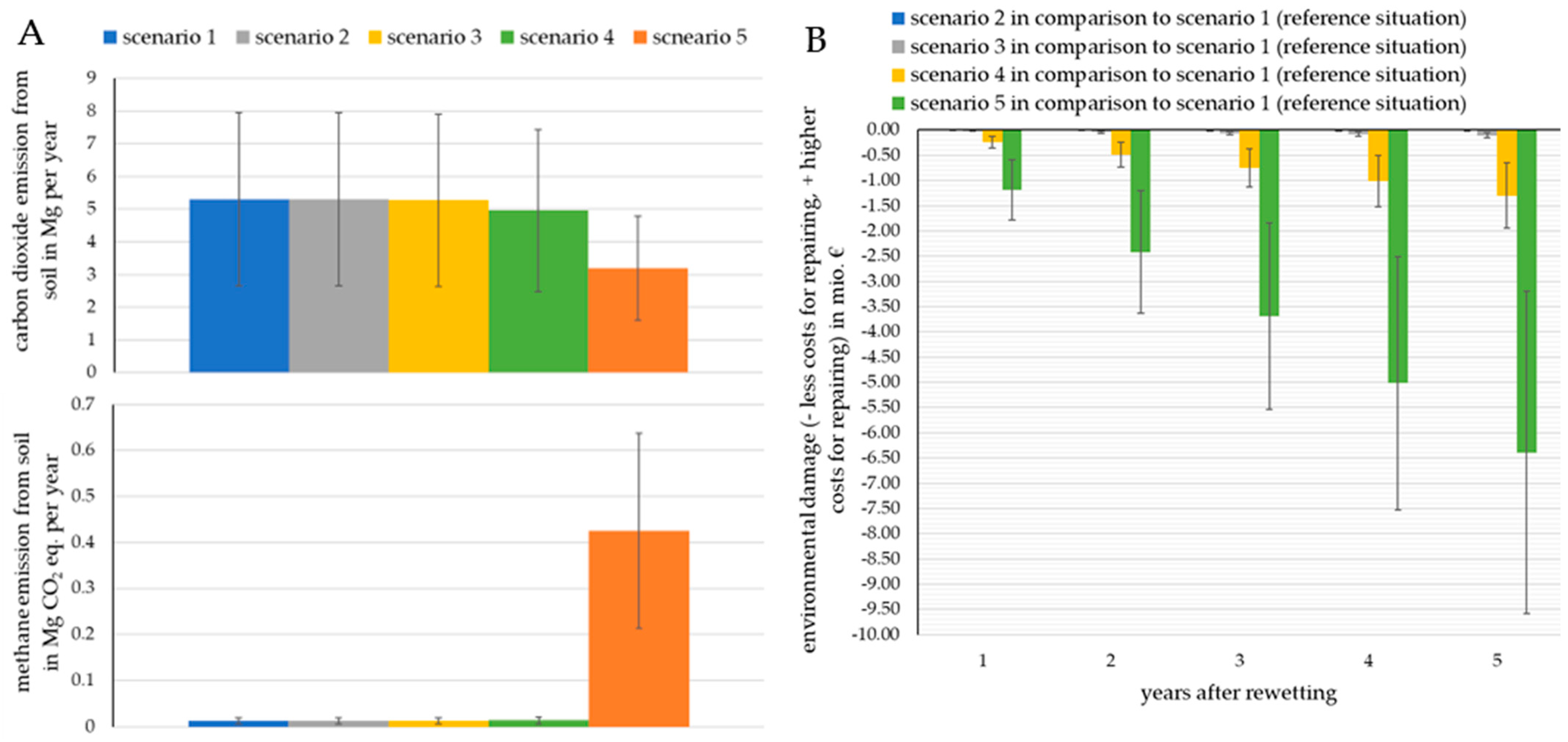
After analyzing the GHG fluxes for different scenarios based on the findings of the authors of [41], it is evident that the process of rewetting degraded peatland could lead to a reduction in climate-damaging gases. A simple examination of emission patterns over five years presents a concise picture. For Scenario 1, approximately 26,565 (CI 95%: 13,282–39,847) Mg CO2 eq. is forecast over a period of five years without significant changes in water management were emitted. The main emissions in Scenario 1 consist of carbon dioxide and amount to 26,500 Mg CO2 eq. (or 99.8%). Methane, on the other hand, contributes only a negligible amount of 63.8 Mg CO2 equivalent (or 0.2%). No significant changes in the emissions situation could be determined for Scenarios 2 to 4. Scenario 2 showed a reduction of three Mg CO2 eq, Scenario 3 showed a reduction of about 135 Mg CO2 eq, and Scenario 4 showed a reduction of about 1720 Mg CO2 eq. Methane emissions for Scenarios 2, 3, and 4 were identical to those of Scenario 1. In Scenarios 1 to 4, 99.8% of the emissions were carbon dioxide and 0.2% were methane, expressed as carbon dioxide equivalent. Scenario 5, which represents the current planning status, suggests a decrease in carbon dioxide emissions, while methane emissions increase at the same time. Specifically, carbon dioxide emissions over a period of five years are estimated at 15,972 (CI 95%: 7986–23,958) Mg CO2 eq. (or 88.3%), while the total methane emission is 2126 (CI 95%: 1063–3189) Mg CO2 equivalent (or 11.7%). Appendix Table A1 shows these results. Figure 14A shows the specific gas components and their theoretical interaction with the soil water table in this study.
The annual emission as a functional unit should only be presented verbally for the reference scenario and the planning variant. In Scenario 1, the emission is 3.60 (CI 95%: 1.80–5.41) kg CO2 eq. per m2 for the rewetting area and 3.21 (CI 95%: 1.60–4.81) kg CO2 per m2 for the remaining area. In Scenario 5, in which a water level of 0.1 m below the earth’s surface was assumed (this corresponds to the current planning status), the emissions per m2 were 1.08 (CI 95%: 0.54–1.62) kg CO2—much lower. Ultimately, Scenario 5, i.e., the current planning, has a reduction potential. An estimated 8466.8 (CI 95%: 4233.4–12,700.2) Mg CO2 equivalents less are emitted in Scenario 5 compared to Scenario 1 for only five years. Scenarios 2 to 4 show savings, but not significant ones.
The valuation was determined by the environmental harm caused by anthropogenic emissions of GHG. Consequently, every ton of carbon dioxide reduced can be assessed based on the prevented costs resulting from environmental damage. For the scenarios that were considered, the estimated environmental damage prevented when comparing Scenarios 1 and 2 was approximately 359 (179–538) EUR per year or 1796 (898–2694) EUR for a 5-year period. For Scenario 3 alone, the prevented damage was EUR 18,875 (9437–28,312 EUR). In Scenario 4, the estimated annual prevented environmental damage was EUR235,784 (with a range of 117,892–353,676 EUR) or 1,178,920 (with a range of 589,460–1,768,381) EUR over the course of five years. Lastly, there was an estimated saving of environmental damage for Scenario 5 of 1,161,642 (580,821–1,742,463) EUR per year, and for the five-year period, this amounts to 5,808,210 (2,904,105–8,712,315) EUR. With these data, the relevance of rewetting measures for degraded peatland areas or organic soils is underlined. The prevention of environmental damage can be observed in Appendix Table A2 and Figure 14B.
4. Discussion
Peatlands play an important role in our landscape. They store significant amounts of carbon in the form of peat and are therefore of great importance to the climate and climate protection [13,41,51]. Peatlands are important building blocks for water retention and biodiversity. Different forms of use and management, as well as the water management of peatlands, can change their function as a habitat, the hydrological conditions, and the dynamics of the release and storage of substances, especially climate-relevant gases [52,53]. In the context of climate change, peatlands are of considerable interest to science, society, and politics, both globally and nationally. On the other hand, peatlands restoration requires multi-level cooperation, long-term monitoring, and an interdisciplinary approach [46,54,55].
Due to the determination of the poor ecological condition of the Boner Nuthe and the degraded peatland in the Rathsbruch area, peatland and water restoration measures were developed. Due to the ownership structure of the Rathsbruch area, these can be implemented with regard to the feasibility of ecological and hydrological measures without any adverse effects on residents. With regard to the planned measures, these include the redesign of the course of the Boner Nuthe, as well as the installation of sills in the Kleine Nuthe, which will renaturate the Boner Nuthe and rewet the peatland. In this way, the ecological, hydrological, and socioeconomic objectives should be achieved. The planned measures also have a positive effect on the microclimate and thus contribute to local adaptation to climate change. This is reinforced by improving the storage capacity of organic carbon in the peatland. Finally, rewetting the Rathsbruch is recommended.
The social aspects of the planning process were considered through public involvement in autumn 2022. A presentation on the municipality level was performed, which open to the public that we might receive their comments. The public feedback was positive; thus, there were no objections from the public, whose outlook was mainly dominated by the opinion that the project is not only valuable for the environment but also for the public as the natural space is enlarged and, in this way, the public recreation space as well. Several people underlined the importance of the project for the future of Zerbst municipality and future generations.
It is a core concern of the German government to advance the protection and renaturation of peatlands. Among other things, the process path should also be optimized. The draft of the natural climate protection action program contains the following sentence: Together with the federal states, we will develop solutions for accelerating and simplifying procedures for rewetting measures. The federal state target agreement on climate protection through peatland protection contains the following measure: The existing legal framework, especially in the areas of agriculture, forestry, and water management, nature, and soil protection, as well as possibly conflicting plans, are checked for obstacles and their effectiveness for peatland protection, and, if necessary, recommendations for adjustments are drawn up. There is also a lot of upheaval with regard to the way in which peatland protecting and the rewetting of the Rathsbruch offers a good opportunity to move forward boldly. In particular, a multi-tiered ownership structure requires lengthy procedures in peatland restoration projects until a balance is achieved for all those involved. This problem does not exist in the Rathsbruch; the owner, Zerbst municipality, is the initiator of the project. The measures described and the natural conditions avoid impacts on the adjacent areas.
A sound monitoring process of rewetting peatland areas is necessary to evaluate the biodiversity status in the long term, as shown for invertebrate communities in the UK [56], and the impact of rewetting peatlands on soil organisms associated with water levels [57]. Remote sensing data, combined with machine learning techniques, provide complementary tools in the progress assessment of the peatland restoration process under various geographical conditions [58,59]. Monitoring and evaluating ecosystem services and the essential ecosystem functions and processes can provide important information for the design and optimization of action plans that serve to develop more sustainable and resilient landscapes. For example, modeling can be used to estimate the effect scenarios of landscape development and the provision of ecosystem services. This means that the advantages and disadvantages of action options for society as a whole can be better disclosed and incorporated into management and action planning. This enables a transparent comparison of different planning variants [60] and facilitates stakeholder participation overall.
GHG accounting can be useful for demonstrating the significance of rewetting approaches to the population and political decision-makers. However, according to [41], there are significant fluctuations in the measured emissions from the German peatland areas (including those subjected to rewetting) that were utilized to derive the equations. Therefore, it is imperative to note that while the savings can be significantly lower, they can also be significantly higher. The estimation of methane emissions was based on parameters specific to cropland, grassland, and settlements. Possible changes in the results may occur if the drained unused land parameters are altered. It should be noted that the results are merely a rough estimate, and assessing the nitrogen supply and corresponding nitrous oxide emissions would worsen the balance of absolute emissions. Nonetheless, there are no expected changes in the effect on the carbon cycle. The comparisons of the different scenarios offer a reliable estimate.
The change in biotope types due to rewetting is subject to fluctuations in the exact type of designation due to climatic uncertainty. The dominant tree species (as long as there is no disturbance from invasive species) will tend to be the drought-tolerant ones. For the LRT 91E0, this means that the species community is difficult to define or closely interlinked with habitats such as quarry forest (alder) or the LRT 9160 [32]. The simple estimation of area development regarding fauna naturally involves large uncertainties that can only be minimized with complex models. For example, frequent use of pesticides in areas outside the study area or the renovation of stables (e.g., Myotis myotis) can have a negative effect on the bat population. Accordingly, detailed models are more effective for both the flora and their communities and the fauna. Nevertheless, this rather simple approach offers good opportunities to interpret various effects.
5. Conclusions
To illustrate the importance of rewetting projects for degraded peatlands, five scenarios with different target soil water levels were considered and the associated GHG emissions for a five-year period were calculated. Generally, the results of the GHG emission simulations performed for different future soil water levels showed that an intensively raised water level reduces GHG emissions. The results for the Rathsbruch peatland showed that raising the water level in 1, 0.8, or 0.5 m steps does not have a substantial effect on reducing the CO2 emission situation. A positive effect starts to become visible at 0.3 m below surface (Scenario 4), resulting in slight CO2 reductions, while in raising the water to 0.1 m below surface (Scenario 5), a substantial CO2 reduction was observed. Across Scenarios 1 through 4, 99.8% of emissions were CO2 and 0.2% were methane. The current planning status in Scenario 5 indicates a significant decrease in CO2 emissions, while simultaneously increasing methane emissions. Although the calculation of GHG emissions from organic soils is dependent on abiotic as well as biotic factors, these simulations were not carried out at this point. The calculated CO2 costs resulting from preventing environmental damage show an environmental benefit with each decimeter of raising water level. The estimated average of the prevented environmental damage in Scenarios 1 and 2 was below 2000 EUR for a 5-year period. For Scenario 3, the prevented damage was already summed up to approx. EUR 19,000 EUR at in five years. In Scenario 4, the estimated average of the annually prevented environmental damage was more than 1 million EUR within 5 years. However, a water level 0.1 m below the surface (Scenario 5) leads to an estimated average saving of environmental damage of nearly 6 million EUR in 5 years.
This research confirms the need to protect peatlands from the consequences of human economic activity and emphasizes the local role of peatlands in the functioning of the local ecosystem and society. The performed research is applicable for the development and planning of reclamation works at the municipal and regional level under the conditions of central Germany (and probably beyond). The tested research strategy is feasible for the conservation and restoration of various types of degraded lands. This research is supported by the policy of society, which is involved in making an informed decision, approving the plan, and implementing it to the reduce greenhouse gas emissions from peatlands and adjacent territories. The rewetting of the Rathsbruch peatland is one example that illustrates the potential for natural climate protection and biodiversity improvement.
With the WFD, all member states are obliged to bring all water bodies into “good ecological” and “good chemical status” by 2015 and, in exceptional cases, by 2027. A “good quantitative” and “good chemical status” must also be achieved for groundwater. The situation is supported by the so-called improvement requirement and the deterioration prohibition. The improvement requirement calls for the creation of “good status” or “good potential” for surface waters. The ban on deterioration, on the other hand, prohibits a deterioration in the status of the water bodies. These investigations have shown that the Boner Nuthe in the project area is in an unsatisfactory-to-bad condition. By creating a new course of the Boner Nuthe, which corresponds to the natural water body type, a good ecological and chemical status of the Boner Nuthe, in terms of the WFD, can be restored. Moreover, the investigation and planning results are in line with the requirements of the planned EU Restoration law that is supposed to enter into force in 2024, and which explicitly aims to restore Europe’s poor-condition habitats.
Author Contributions
Conceptualization, P.S. and V.L.; methodology, P.S., V.L. and B.E.; software, T.F.; validation, P.S., V.L. and H.J.; formal analysis, B.E., T.F. and H.J. investigation, V.L., P.S., B.E. and T.F.; resources, H.J.; data curation, V.L. and T.F.; writing—original draft preparation, P.S. and F.-C.M.; writing—review and editing, V.L., F.-C.M., T.F., H.J. and B.E.; visualization, T.F.; supervision, P.S. and V.L.; project administration, P.S. and V.L.; funding acquisition, P.S. and V.L. All authors have read and agreed to the published version of the manuscript.
Funding
This research received no external funding.
Data Availability Statement
The data presented in this study are available on request from the corresponding author. The data are not publicly available due to privacy restrictions.
Acknowledgments
We are grateful to the ecological engineering students for their field investigations and design ideas, namely, Jonathan Hawran, Daniel Kramer, Valentin Schmideder, and Lotte Varelmann. We thank the anonymous reviewers for their valuable comments.
Conflicts of Interest
The authors declare no conflicts of interest.
Appendix A

Table A1.
Overall results for the different scenarios, years after rewetting, and corresponding GHG fluxes.
Table A1.
Overall results for the different scenarios, years after rewetting, and corresponding GHG fluxes.
| Scenario 1 | Summed emissions | Carbon dioxide emissions | Methane emissions | ||||||
| Water level = −1 m | Mg CO2 eq. | Mg CO2 eq. | Mg CO2 eq. | ||||||
| year after rewetting | mean | min | max | mean | min | max | mean | min | max |
| 1 | 5313 | (2656–7969) | 5300 | (2650–7950) | 13 | (6–19) | |||
| 2 | 10,626 | (5313–15,939) | 10,600 | (5300–15,901) | 26 | (13–38) | |||
| 3 | 15,939 | (7969–23,908) | 15,901 | (7950–23,851) | 38 | (19–57) | |||
| 4 | 21,252 | (10,626–31,878) | 21,201 | (10,600–31,801) | 51 | (26–77) | |||
| 5 | 26,565 | (13,282–39,847) | 26,501 | (13,250–39,751) | 64 | (32–96) | |||
| Scenario 2 | Summed emissions | Carbon dioxide emissions | Methane emissions | ||||||
| Water level = −0.8 m | Mg CO2 eq. | Mg CO2 eq. | Mg CO2 eq. | ||||||
| year after rewetting | mean | min | max | mean | min | max | mean | min | max |
| 1 | 5312 | (2656–7969) | 5300 | (2650–7949) | 13 | (6–19) | |||
| 2 | 10,625 | (5312–15,937) | 10,599 | (5300–15,899) | 26 | (13–38) | |||
| 3 | 15,937 | (7969–23,906) | 15,899 | (7949–23,848) | 38 | (19–57) | |||
| 4 | 21,250 | (10,625–31,875) | 21,199 | (10,599–31,798) | 51 | (26–77) | |||
| 5 | 26,562 | (13,281–39,843) | 26,498 | (13,249–39,747) | 64 | (32–96) | |||
| Scenario 3 | Summed emissions | Carbon dioxide emissions | Methane emissions | ||||||
| Water level = –0.5 m | Mg CO2 eq. | Mg CO2 eq. | Mg CO2 eq. | ||||||
| year after rewetting | mean | min | max | mean | min | max | mean | min | max |
| 1 | 5285 | (2643–7928) | 5273 | (2636–7909) | 13 | (6–19) | |||
| 2 | 10,571 | (5285–15,856) | 10,545 | (5273–15,818) | 26 | (13–38) | |||
| 3 | 15,856 | (7928–23,784) | 15,818 | (7909–23,727) | 38 | (19–57) | |||
| 4 | 21,142 | (10,571–31,713) | 21,091 | (10,545–31,636) | 51 | (26–77) | |||
| 5 | 26,427 | (13,214–39,641) | 26,363 | (13,182–39,545) | 64 | (32–96) | |||
| Scenario 4 | Summed emissions | Carbon dioxide emissions | Methane emissions | ||||||
| Water level = −0.3 m | Mg CO2 eq. | Mg CO2 eq. | Mg CO2 eq. | ||||||
| year after rewetting | mean | min | max | mean | min | max | mean | min | max |
| 1 | 4969 | (2485–7454) | 4956 | (2478–7435) | 13 | (6–19) | |||
| 2 | 9938 | (4969–14,908) | 9913 | (4956–14,869) | 26 | (13–39) | |||
| 3 | 14,908 | (7454–22,362) | 14,869 | (7435–22,304) | 39 | (19–58) | |||
| 4 | 19,877 | (9938–29,815) | 19,826 | (9913–29,738) | 51 | (26–77) | |||
| 5 | 24,846 | (12,423–37,269) | 24,782 | (12,391–37,173) | 64 | (32–96) | |||
| Scenario 5 | Summed emissions | Carbon dioxide emissions | Methane emissions | ||||||
| Water level = −0.1 m | Mg CO2 eq. | Mg CO2 eq. | Mg CO2 eq. | ||||||
| year after rewetting | mean | min | max | mean | min | max | mean | min | max |
| 1 | 3620 | (1810–5429) | 3194 | (1597–4792) | 425 | (213–638) | |||
| 2 | 7239 | (3620–10,859) | 6389 | (3194–9583) | 850 | (425–1275) | |||
| 3 | 10,859 | (5429–16,288) | 9583 | (4792–14,375) | 1275 | (638–1913) | |||
| 4 | 14,478 | (7239–21,718) | 12,778 | (6389–19,167) | 1701 | (850–2551) | |||
| 5 | 18,098 | (9049–27,147) | 15,972 | (7986–23,958) | 2126 | (1063–3189) | |||
Table A2.
Environmental damage costs.
| Scenario 1 | Emissions | Environmental damage costs (time preference: 2%) | ||||
| Water level = –1 m | Mg CO2 eq. | EUR | ||||
| year after rewetting/price in EUR per Mg CO2 | mean | min | max | mean | min | max |
| 1/699.72 | 5313 | (2656−7969) | 3,790,469 | (1,895,234−5685,703) | ||
| 2/713.44 | 10,626 | (5313−15,939) | 7,726,724 | (3,863,362−11,590,086) | ||
| 3/727.16 | 15,939 | (7969−23,908) | 11,808,767 | (5,904,384−17,713,151) | ||
| 4/740.88 | 21,252 | (10,626−31,878) | 16,036,598 | (8,018,299−24,054,896) | ||
| 5/754.60 | 26,565 | (13,282−39,847) | 20,410,215 | (10,205,108−30,615,323) | ||
| Scenario 2 | Emissions | Environmental damage costs (time preference: 2%) | ||||
| Water level = –0.8 m | Mg CO2 eq. | EUR | ||||
| year after rewetting/price in EUR per Mg CO2 | mean | min | max | mean | min | max |
| 1/699.72 | 5312 | (2656−7969) | 3,790,102 | (1,895,051−5685,153) | ||
| 2/713.44 | 10,625 | (5312−15,937) | 7,725,977 | (3,862,989−11,588,966) | ||
| 3/727.16 | 15,937 | (7969−23,906) | 11,807,625 | (5,903,812−17,711,437) | ||
| 4/740.88 | 21,250 | (10,625−31,875) | 16,035,046 | (8,017,523−24,052,568) | ||
| 5/754.60 | 26,562 | (13,281−39,843) | 20,408,239 | (10,204,120−30,612,359) | ||
| Scenario 3 | Emissions | Environmental damage costs (time preference: 2%) | ||||
| Water level = –0.5 m | Mg CO2 eq. | EUR | ||||
| year after rewetting/price in EUR per Mg CO2 | mean | min | max | mean | min | max |
| 1/699.72 | 5285 | (2643−7928) | 3,771,216 | (1,885,608−5,656,824) | ||
| 2/713.44 | 10,571 | (5285−15,856) | 7,687,464 | (3,843,732−11,531,196) | ||
| 3/727.16 | 15,856 | (7928−23,784) | 11,748,745 | (5,874,372−17,623,117) | ||
| 4/740.88 | 21,142 | (10,571−31,713) | 15,955,058 | (7,977,529−23,932,586) | ||
| 5/754.60 | 26,427 | (13,214−39,641) | 20,306,403 | (10,153,201−30,459,604) | ||
| Scenario 4 | Emissions | Environmental damage costs (time preference: 2%) | ||||
| Water level = –0.3 m | Mg CO2 eq. | EUR | ||||
| year after rewetting/price in EUR per Mg CO2 | mean | min | max | mean | min | max |
| 1/699.72 | 4969 | (2485−7454) | 3,549,969 | (1,774,984−5,324,953) | ||
| 2/713.44 | 9938 | (4969−14,908) | 7,236,293 | (3,618,147−10,854,440) | ||
| 3/727.16 | 14,908 | (7454−22,362) | 11,058,974 | (5,529,487−16,588,461) | ||
| 4/740.88 | 19,877 | (9938−29,815) | 15,018,010 | (7,509,005−22,527,015) | ||
| 5/754.60 | 24,846 | (12,423−37,269) | 19,113,402 | (9,556,701−28,670,103) | ||
| Scenario 5 | Emissions | Environmental damage costs (time preference: 2%) | ||||
| Water level = –0.1 m | Mg CO2 eq. | EUR | ||||
| year after rewetting/price in EUR per Mg CO2 | mean | min | max | mean | min | max |
| 1/699.72 | 3620 | (1810−5429) | 2,605,594 | (1,302,797−3,908,391) | ||
| 2/713.44 | 7239 | (3620−10,859) | 5,310,509 | (2,655,254−7,965,763) | ||
| 3/727.16 | 10,859 | (5429−16,288) | 8,114,746 | (4,057,373−12,172,119) | ||
| 4/740.88 | 14,478 | (7239−21,718) | 11,018,304 | (5,509,152−16,527,456) | ||
| 5/754.60 | 18,098 | (9049−27,147) | 14,021,184 | (7,010,592−21,031,776) | ||
Figure A1.
(A) Grus grus overflying alder swamp forest; (B) Pyrrhosoma nymphula during mating on Agrostis capillaris; (C) Coenonympha pamphilus; (D) alder–birch swamp forest. Source: Tino Fauk.
Figure A1.
(A) Grus grus overflying alder swamp forest; (B) Pyrrhosoma nymphula during mating on Agrostis capillaris; (C) Coenonympha pamphilus; (D) alder–birch swamp forest. Source: Tino Fauk.

References
- Jewell, J.; Cherp, A. On the political feasibility of climate change mitigation pathways: Is it too late to keep warming below 1.5 °C? WIREs Clim. Chang. 2019, 11, e621. [Google Scholar] [CrossRef]
- Shin, Y.-J.; Arneth, A.; Chowdhury, R.; Midgley, G.F.; Bukvareva, E.; Heinimann, A.; Horcea-Milcu, A.I.; Kolb, M.; Leadley, P.; Oberdorff, T.; et al. Plausible futures of nature, its contributions to people and their good quality of life. In The Global Assessment Report on Biodiversity and Ecosystem Services; Brondízio, E.S., Settele, J., Diaz, S., Ngo, H.T., Eds.; IPBES: Bonn, Germany, 2019; pp. 600–766. [Google Scholar]
- Schneider, P.; Fauk, T.; Mihai, F.C. Reclaiming Urban Brownfields and Industrial Areas–Potentials for Agroecology. In Agroecological Approaches for Sustainable Soil Management; Prasad, M.N.V., Kumar, C., Eds.; Wiley: Hoboken, NJ, USA, 2023; pp. 409–436. [Google Scholar]
- Mihai, F.C.; Schneider, P.; Eva, M. Ecological engineering and green infrastructure in mitigating emerging urban environmental threats. In Handbook of Ecological and Ecosystem Engineering; Prasad, M.N.V., Ed.; Wiley: Hoboken, NJ, USA, 2021; pp. 95–121. [Google Scholar] [CrossRef]
- Temmink, R.J.; Robroek, B.J.; van Dijk, G.; Koks, A.H.; Käärmelahti, S.A.; Barthelmes, A.; Wassen, M.J.; Ziegler, R.; Steele, M.N.; Giesen, W.; et al. Wetscapes: Restoring and maintaining peatland landscapes for sustainable futures. Ambio 2023, 52, 1519–1528. [Google Scholar] [CrossRef]
- Zou, J.; Ziegler, A.D.; Chen, D.; McNicol, G.; Ciais, P.; Jiang, X.; Zheng, C.; Wu, J.; Wu, J.; Lin, Z.; et al. Rewetting global wetlands effectively reduces major greenhouse gas emissions. Nat. Geosci. 2022, 15, 627–632. [Google Scholar] [CrossRef]
- Koch, J.; Elsgaard, L.; Greve, M.H.; Gyldenkærne, S.; Hermansen, C.; Levin, G.; Wu, S.; Stisen, S. Water-table-driven greenhouse gas emission estimates guide peatland restoration at national scale. Biogeosciences 2023, 20, 2387–2403. [Google Scholar] [CrossRef]
- Zak, D.; McInnes, R.J. A call for refining the peatland restoration strategy in Europe. J. Appl. Ecol. 2022, 59, 2698–2704. [Google Scholar] [CrossRef]
- Minasny, B.; Adetsu, D.V.; Aitkenhead, M.; Artz, R.R.; Baggaley, N.; Barthelmes, A.; Beucher, A.; Caron, J.; Conchedda, G.; Connolly, J.; et al. Mapping and monitoring peatland conditions from global to field scale. Biogeochemistry 2023. [Google Scholar] [CrossRef]
- Wetlands International 2022. Peatlands in the EU Nature Restoration Law—A Factsheet. Available online: https://europe.wetlands.org/news/peatlands-in-the-eu-nature-restoration-law-a-factsheet/ (accessed on 14 July 2022).
- Bundesministerium für Umwelt, Naturschutz, nukleare Sicherheit und Verbraucherschutz. Nationale Moorschutzstrategie. 2022. Available online: https://www.bmuv.de/download/nationale-moorschutzstrategie (accessed on 8 September 2023).
- Brunotte, E.; Gebhardt, H.; Meurer, M.; Meusburger, P.; Nipper, J. Lexikon der Geographie; Spektrum: Heidelberg, Germany, 2002; ISBN 3-8274-0416-9. [Google Scholar]
- Ahmad, S.; Liu, H.; Alam, S.; Günther, A.; Jurasinski, G.; Lennartz, B. Meteorological Controls on Water Table Dynamics in Fen Peatlands Depend on Management Regimes. Front. Earth Sci. 2021, 9, 630469. [Google Scholar] [CrossRef]
- Chen, C.; Loft, L.; Matzdorf, B. Lost in action: Climate friendly use of European peatlands needs coherence and incentive-based policies. Environ. Sci. Policy 2023, 145, 104–115. [Google Scholar] [CrossRef]
- Byg, A.; Novo, P.; Kyle, C. Caring for Cinderella—Perceptions and experiences of peatland restoration in Scotland. People Nat. 2020, 5, 302–312. [Google Scholar] [CrossRef]
- Martino, S.; Kenter, J.O.; Albers, N.; Whittingham, M.J.; Young, D.M.; Pearce-Higgins, J.W.; Martin-Ortega, J.; Glenk, K.; Reed, M.S. Trade-offs between the natural environment and recreational infrastructure: A case study about peatlands under different management scenarios. Land Use Policy 2022, 123, 106401. [Google Scholar] [CrossRef]
- Chen, C.; Loft, L.; Sattler, C.; Matzdorf, B. Developing regional voluntary carbon markets for peatlands: Innovation processes and influencing factors. Clim. Policy 2022, 23, 238–253. [Google Scholar] [CrossRef]
- Banerjee, A.; Schuitema, G. Spatial justice as a prerequisite for a just transition in rural areas? The case study from the Irish peatlands. Environ. Plan. C Politi. Space 2023, 41, 1096–1112. [Google Scholar] [CrossRef]
- Zerbe, S. Actors and Stakeholders and Their Role in Ecosystem Restoration: Conflict Resolution and Acceptance Through Participation. In Restoration of Ecosystems–Bridging Nature and Humans: A Transdisciplinary Approach; Springer: Berlin/Heidelberg, Germany, 2023; pp. 473–486. [Google Scholar]
- Räsänen, A.; Albrecht, E.; Annala, M.; Aro, L.; Laine, A.M.; Maanavilja, L.; Mustajoki, J.; Ronkanen, A.-K.; Silvan, N.; Tarvainen, O.; et al. After-use of peat extraction sites–A systematic review of biodiversity, climate, hydrological and social impacts. Sci. Total Environ. 2023, 882, 163583. [Google Scholar] [CrossRef] [PubMed]
- Lin, F.; Zuo, H.; Ma, X.; Ma, L. Comprehensive assessment of nitrous oxide emissions and mitigation potentials across European peatlands. Environ. Pollut. 2022, 301, 119041. [Google Scholar] [CrossRef] [PubMed]
- Günther, A.; Barthelmes, A.; Huth, V.; Joosten, H.; Jurasinski, G.; Koebsch, F.; Couwenberg, J. Prompt rewetting of drained peatlands reduces climate warming despite methane emissions. Nat. Commun. 2020, 11, 1644. [Google Scholar] [CrossRef] [PubMed]
- Schwieger, S.; Kreyling, J.; Peters, B.; Gillert, A.; von Lukas, U.F.; Jurasinski, G.; Köhn, D.; Blume-Werry, G. Rewetting prolongs root growing season in minerotrophic peatlands and mitigates negative drought effects. J. Appl. Ecol. 2022, 59, 2106–2116. [Google Scholar] [CrossRef]
- Makrickas, E.; Manton, M.; Angelstam, P.; Grygoruk, M. Trading wood for water and carbon in peatland forests? Rewetting is worth more than wood production. J. Environ. Manag. 2023, 341, 117952. [Google Scholar] [CrossRef] [PubMed]
- Dahm, J. German Stakeholders Divided Over EU’s New Peatland Targets. 2022. Available online: https://www.euractiv.com/section/agriculture-food/news/german-stakeholders-divided-over-eus-new-peatland-targets/ (accessed on 8 September 2023).
- Schaller, C.; Hofer, B.; Klemm, O. Greenhouse Gas Exchange of a NW German Peatland, 18 Years After Rewetting. J. Geophys. Res. Biogeosciences 2022, 127, e2020JG005960. [Google Scholar] [CrossRef]
- Tanneberger, F.; Schröder, C.; Hohlbein, M.; Lenschow, U.; Permien, T.; Wichmann, S.; Wichtmann, W. Climate Change Mitigation through Land Use on Rewetted Peatlands—Cross-Sectoral Spatial Planning for Paludiculture in Northeast Germany. Wetlands 2020, 40, 2309–2320. [Google Scholar] [CrossRef]
- Tanneberger, F.; Moen, A.; Barthelmes, A.; Lewis, E.; Miles, L.; Sirin, A.; Tegetmeyer, C.; Joosten, H. Mires in Europe—Regional Diversity, Condition and Protection. Diversity 2021, 13, 381. [Google Scholar] [CrossRef]
- Saxony-Anhalt State Office for Surveying and Geoinformation (LVermGeo)—Digital Terrain Model. Available online: https://www.lvermgeo.sachsen-anhalt.de/de/gdp-open-data.html (accessed on 20 January 2024).
- Billetoft, B.; Winter-Huneck, B.; Peterson, J.; Schmidt, W. 9160 Subatlantischer oder mitteleuropäischer Stieleichenwald oder Eichen-Hainbuchenwald (Carpinion betuli). In Naturschutz im Land Sachsen-Anhalt; Landesamt für Umweltschutz, Ed.; 2002; Publisher: Federal State Sachsen-Anhalt, Authority for Environmental Protection; Available online: https://lau.sachsen-anhalt.de/fileadmin/Bibliothek/Politik_und_Verwaltung/MLU/LAU/Naturschutz/Arten-_und_Biotopschutz/Lebensraumtypen/Dateien/LRT_9160.pdf (accessed on 20 January 2024).
- LPR Landschaftsplanung Dr. Reichhoff GmbH. Managementplan für das FFH-Gebiet. Obere Nuthe-Läufe, 2022; unpublished. [Google Scholar]
- Billetoft, B.; Winter-Huneck, B.; Peterson, J.; Schmidt, W. 91E0* Auenwälder mit Alnus glutinosa und Fraxinus excelsior (Alno padion, Alnion incanae, Salicion albae). In Naturschutz im Land Sachsen-Anhalt; Landesamt für Umweltschutz, Ed.; 2002; Publisher: Federal State Sachsen-Anhalt, Authority for Environmental Protection; Available online: https://lau.sachsen-anhalt.de/fileadmin/Bibliothek/Politik_und_Verwaltung/MLU/LAU/Naturschutz/Arten-_und_Biotopschutz/Lebensraumtypen/Dateien/LRT_91E0-1.pdf (accessed on 20 January 2024).
- Jäger, U.; Peterson, J.; Blank, C. 6510 Magere Flachland-Mähwiesen (Alopecurus pratensis, Sanguisorba officinalis). In Naturschutz im Land Sachsen-Anhalt; Landesamt für Umweltschutz, Ed.; 2002; Publisher: Federal State Sachsen-Anhalt, Authority for Environmental Protection; Available online: https://lau.sachsen-anhalt.de/fileadmin/Bibliothek/Politik_und_Verwaltung/MLU/LAU/Naturschutz/Arten-_und_Biotopschutz/Lebensraumtypen/Dateien/LRT_6510.pdf (accessed on 20 January 2024).
- Saxony-Anhalt State Office for Geology and Mining (LAGB)—Soil Maps. Available online: https://www.geodatenportal.sachsen-anhalt.de/mapapps/resources/apps/viewer_v40/index.html?lang=de (accessed on 20 January 2024).
- Lüderitz, V.; Speierl, T.; Langheinrich, U.; Völkl, W.; Gersberg, R.M. Restoration of the Upper Main and Rodach rivers—The success and its measurement. Ecol. Eng. 2011, 37, 2044–2055. [Google Scholar] [CrossRef]
- Seidel, M.; Li, F.; Langheinrich, U.; Gersberg, R.M.; Lüderitz, V. Self-dynamics as a driver for restoration success in a lowland stream reach. Limnologica 2021, 88, 125873. [Google Scholar] [CrossRef]
- Dußling, U. Handbuch zu fiBS, Hilfestellung und Hinweise zur sachgerechten Anwendung des fischbasierten Bewertungsverfahrens (Manual on fiBS. Assistance and advice on the proper use of the fish-based assessment procedure fiBS (in German), Version 8.0.6. Schriftenreihe des Verbandes Deutscher Fischereiverwaltungsbeamter und Fischereiwissenschaftler (VDFF) e.V. Verbandes Deutscher Fischereiverwaltungsbeamter und Fischereiwissenschaftler (VDFF): Rostock, Germany, 2009; Heft 15.
- National Ministry for Environment, Nature Protection, Nuclear Safety and Consumer Protection. National Strategy on Biological Diversity 2030—First draft, Nationale Strategie zur Biologischen Vielfalt 2030—Diskussionsvorschläge des BMUV. 2022. Available online: https://www.bmuv.de/themen/naturschutz/allgemeines-/-strategien/nationale-strategie (accessed on 12 October 2023).
- Jia, G.; Shevliakova, E.; Artaxo, P.; De Noblet-Ducoudré, N.; Houghton, R.; House, J.; Kitajima, K.; Lennard, C.; Popp, A.; Sirin, A.; et al. Land-climate interactions. In Climate Change and Land: An IPCC Special Report on Climate Change, Desertification, Land Degradation, Sustainable Land Management, Food Security, and Greenhouse Gas Fluxes in Terrestrial Ecosystems; Schukla, P.R., Skea, J., Calvo Buendia, E., Masson-Delmotte, V., Partner, H.-O., Roberts, D.C., Zhai, P., Slade, R., Connors, S., van Diemen, R., et al., Eds.; Report of the Intergovernmental Panel on Climate Change; Intergovernmental Panel on Climate Change: Geneva, Switzerland, 2019. [Google Scholar] [CrossRef]
- Olsson, L.; Barbosa, H.; Bhadwal, S.; Cowie, A.; Delusca, K.; Flores-Renteria, D.; Hermans, K.; Jobbagy, E.; Kurz, W.; Li, D.; et al. Land degradation. In Climate Change and Land: An IPCC Special Report on Climate Change, Desertification, Land Degradation, Sustainable Land Management, Food Security, and Greenhouse Gas Fluxes in Terrestrial Ecosystems; Schukla, P.R., Skea, J., Calvo Buendia, E., Masson-Delmotte, V., Partner, H.-O., Roberts, D.C., Zhai, P., Slade, R., Connors, S., van Diemen, R., et al., Eds.; Report of the Intergovernmental Panel on Climate Change; Intergovernmental Panel on Climate Change: Geneva, Switzerland, 2019. [Google Scholar] [CrossRef]
- Tiemeyer, B.; Freibauer, A.; Borraz, E.A.; Augustin, J.; Bechtold, M.; Beetz, S.; Beyer, C.; Ebli, M.; Eickenscheidt, T.; Fiedler, S.; et al. A new methodology for organic soils in national greenhouse gas inventories: Data synthesis, derivation and application. Ecol. Indic. 2020, 109, 105838. [Google Scholar] [CrossRef]
- openLCA 1.9.0. Copyright (c) 2007–2019 GreenDelta. openLCA with Ecoinvent Database. Software. Available online: http://openlca.org (accessed on 20 November 2023).
- McConkey, B.G.; Ogle, S.; Chirinda, N.; Kishimoto, A.W.M.; Baldock, J.; Trunov, A.; Alsaker, C.; Lehmann, J.; Woolf, D. Chapter 6—Grassland. In 2019 Refinement to the 2006 IPCC Guidelines for National Greenhouse Gas Inventories—Volume 4 Agriculture, Forestry, and other Land Use; Calvo Buendia, E., Tanabe, K., Kranjc, A., Baasansuren, J., Fukuda, M., Ngarize, S., Osaka, A., Py-rozhenko, Y., Shermanau, P., Federici, S., Eds.; Report of the Intergovernmental Panel on Climate Change; Intergovernmental Panel on Climate Change: Geneva, Switzerland, 2019; ISBN 978-4-88788-232-4. [Google Scholar]
- Fauk, T.; Schneider, P. Modeling urban tree growth as a part of the green infrastructure to estimate ecosystem services in urban planning. Front. Environ. Sci. 2023, 11, 1090652. [Google Scholar] [CrossRef]
- Gensior, A.; Fuß, R.; Laggner, A.; Döring, U. Grünland. In Berichterstattung unter der Klimarahmenkonvention der Vereinten Nationen und dem Kyoto-Protokoll—Nationaler Inventarbericht zum Deutschen Treibhausgasinventar 1990–2020; Günther, D., Gniffke, P., Eds.; Umweltbundesamt: Dessau-Roßlau, Germany, 2022; ISSN 1862-4359. [Google Scholar]
- Zerbe, S. Chapter 8—Moore. In Renaturierung von Ökosystemen im Spannungsfeld von Mensch und Umwelt; Springer Nature: Berlin/Heidelberg, Germany, 2019; pp. 151–183. [Google Scholar] [CrossRef]
- Matthey, A.; Bünger, B. Methodenkonvention 3.1 zur Ermittlung von Umweltkosten—Kostensätze; Umweltbundesamt: Dessau-Roßlau, Germany, 2020. ISSN 1862-4804. Available online: https://www.umweltbundesamt.de/sites/default/files/medien/1410/publikationen/2020-12-21_methodenkonvention_3_1_kostensaetze.pdf (accessed on 20 November 2023).
- Bünger, B.; Matthey, A. Methodenkonvention 3.0 zur Ermittlung von Umweltkosten—Methodische Grundlagen; Umweltbundesamt: Dessau-Roßlau, Germany, 2018. Available online: https://www.umweltbundesamt.de/sites/default/files/medien/1410/publikationen/2018-11-12_methodenkonvention-3-0_methodische-grundlagen.pdf (accessed on 20th November 2023).
- Wittig, R.; Niekisch, M. Chapter 7—The habitats in Central Europe (Die Lebensräume in Mitteleuropa). In Biodiversität: Grundlagen, Gefährdung, Schutz; Springer Nature: Berlin/Heidelberg, Germany, 2014; pp. 149–191. Available online: https://link.springer.com/book/10.1007/978-3-642-54694-5 (accessed on 20 November 2023).
- Bartsch, N.; Röhrig, E. Chapter 5—Forest-like plant formations (Waldähnliche Pflanzenformationen). In Waldökologie; Springer Nature: Berlin/Heidelberg, Germany, 2016; pp. 43–53. Available online: https://link.springer.com/book/10.1007/978-3-662-44268-5 (accessed on 20 November 2023).
- Xu, S.; Wang, M.; Zhou, J.; Huang, Y.; Zhang, J.; Wang, S. Soil bacteria, archaea, and enzymatic activity of natural and rewetted peatlands display varying patterns in response to water levels. Catena 2023, 228, 107191. [Google Scholar] [CrossRef]
- Zhou, Y.; Sachs, T.; Li, Z.; Pang, Y.; Xu, J.; Kalhori, A.; Wille, C.; Peng, X.; Fu, X.; Wu, Y.; et al. Long-term effects of rewetting and drought on GPP in a temperate peatland based on satellite remote sensing data. Sci. Total Environ. 2023, 882, 163395. [Google Scholar] [CrossRef] [PubMed]
- Ball, J.; Gimona, A.; Cowie, N.; Hancock, M.; Klein, D.; Donaldson-Selby, G.; Artz, R.R. Assessing the Potential of using Sentinel-1 and 2 or high-resolution aerial imagery data with Machine Learning and Data Science Techniques to Model Peatland Restoration Progress—A Northern Scotland case study. Int. J. Remote Sens. 2023, 44, 2885–2911. [Google Scholar] [CrossRef]
- Stammel, B.; Fischer, C.; Cyffka, B.; Albert, C.; Damm, C.; Dehnhardt, A.; Fischer, H.; Foeckler, F.; Gerstner, L.; Hoffmann, T.G.; et al. Assessing land use and flood management impacts on ecosystem services in a river landscape (Upper Danube, Germany). River Res. Appl. 2020, 37, 209–220. [Google Scholar] [CrossRef]
- Doelman, J.C.; Verhagen, W.; Stehfest, E.; van Vuuren, D.P. The role of peatland degradation, protection and restoration for climate change mitigation in the SSP scenarios. Environ. Res. Clim. 2023, 2, 035002. [Google Scholar] [CrossRef]
- Beadle, J.M.; Holden, J.; Brown, L.E. Landscape-scale peatland rewetting benefits aquatic invertebrate communities. Biol. Conserv. 2023, 283, 110116. [Google Scholar] [CrossRef]
- Robinson, C.H.; Ritson, J.P.; Alderson, D.M.; Malik, A.A.; Griffiths, R.I.; Heinemeyer, A.; Gallego-Sala, A.V.; Quillet, A.; Robroek, B.J.M.; Evans, C.; et al. Aspects of microbial communities in peatland carbon cycling under changing climate and land use pressures. Mires Peat 2023, 29, 2. [Google Scholar] [CrossRef]
- Howson, T.; Evans, M.; Allott, T.; Shuttleworth, E.; Johnston, A.; Rees, J.; Milledge, D.; Edokpa, D.; Lockyer, C.; Kay, M.; et al. Peatland gully restoration with stone and timber dams (Kinder Plateau, UK). Ecol. Eng. 2023, 195, 107066. [Google Scholar] [CrossRef]
- Fatimah, Y.A.; Prasojo, Z.H.; Smith, S.W.; Rahman, N.E.B.; Wardle, D.A.; Chong, K.Y.; Saad, A.; Lee, J.S. Multi-level actor-network: Case of Peatland programs in a Riau Village, Indonesia (1974–2020). Geoforum 2023, 145, 103829. [Google Scholar] [CrossRef]
- Temmink, R.J.M.; Vroom, R.J.E.; van Dijk, G.; Käärmelahti, S.A.; Koks, A.H.W.; Joosten, H.; Krebs, M.; Gaudig, G.; Brust, K.; Lamers, L.P.M.; et al. Restoring organic matter, carbon and nutrient accumulation in degraded peatlands: 10 years Sphagnum paludiculture. Biogeochemistry 2023, 1–15. [Google Scholar] [CrossRef]
Figure 2.
Impressions of the investigation area: (A) rewetting area with blooming Ranunculus repens; (B) example of a drainage (photo credit: Petra Schneider).
Figure 2.
Impressions of the investigation area: (A) rewetting area with blooming Ranunculus repens; (B) example of a drainage (photo credit: Petra Schneider).

Figure 3.
Impressions of the soil investigations: (A) excavation and (B) drilling impression (photo credit: Petra Schneider).
Figure 3.
Impressions of the soil investigations: (A) excavation and (B) drilling impression (photo credit: Petra Schneider).

Figure 4.
(A) Elevation level above zero, based on the digital terrain model [29]; (B) topsoil species based on soil maps [34] (rearrangement by Tino Fauk).

Figure 5.
(A,B) Impressions of macroinvertebrates samples (photo credit: Petra Schneider).

Figure 6.
(A) Simplified planned measures for the restoration of Rathsbruch (manually prepared by Tino Fauk); (B) affected areas that were not included in the life cycle assessment based on DLM 50 [29] (manipulation and rearrangement by Fauk; background map: OSM).
Figure 6.
(A) Simplified planned measures for the restoration of Rathsbruch (manually prepared by Tino Fauk); (B) affected areas that were not included in the life cycle assessment based on DLM 50 [29] (manipulation and rearrangement by Fauk; background map: OSM).

Figure 7.
Rewetting scenario schemes based on the current land use, natural carbon, and nitrogen cycles (adapted from [34,35,36]) (figure source: Tino Fauk).

Figure 8.
Organic content of soil for Rathsbruch (planning area) (figure by Tino Fauk).

Figure 12.
(A) Design solution for Boner Nuth; (B) overall planning solution with beaver dams and measures for ditches, along with the rewetting area (rearranged by Tino Fauk).
Figure 12.
(A) Design solution for Boner Nuth; (B) overall planning solution with beaver dams and measures for ditches, along with the rewetting area (rearranged by Tino Fauk).

Figure 13.
Future biotope types for the FFH area after rewetting after a mid-to-long-term succession. Source: Tino Fauk, based on Supplementary Material from [31].
Figure 13.
Future biotope types for the FFH area after rewetting after a mid-to-long-term succession. Source: Tino Fauk, based on Supplementary Material from [31].

Figure 14.
(A) Emissions of various GHG components given in carbon dioxide equivalents for Scenarios 1 to 5; (B) illustration of various scenarios in different time frames after rewetting. Negative outcomes can be interpreted as mitigation of environmental damage.
Figure 14.
(A) Emissions of various GHG components given in carbon dioxide equivalents for Scenarios 1 to 5; (B) illustration of various scenarios in different time frames after rewetting. Negative outcomes can be interpreted as mitigation of environmental damage.

Table 1.
Current land cover and use (LULC) with the corresponding areas of Rathsbruch.
| LULC | Area [ha] |
|---|---|
| Cropland (non-irrigation) | 0.18 |
| Dirt roads | 2.22 |
| Paved Roads | 0.04 |
| Deciduous forest | 46.96 |
| Mixed forest | 57.77 |
| Coniferous forest | 9.98 |
| Channels, ditches, and river | 3.31 |
| Pasture and meadow | 174.74 |
Table 2.
Soil water level for the scenarios and different land use and land cover (LULC).
| Scenario | “Pasture and Meadow” [m] | “Rewetting” [m] |
|---|---|---|
| 1 | −1.0 | −1.0 |
| 2 | −1.0 | −0.8 |
| 3 | −1.0 | −0.5 |
| 4 | −1.0 | −0.3 |
| 5 | −1.0 | −0.1 |
Table 3.
Results of MI-based evaluation for Nuthe stream in the rewetting area and downstream.
| Sector 1: Rewetting Area | Sector 2: Downstream | |
|---|---|---|
| Water body type | 11 | 14 |
| MI species number | 26 | 53 |
| Saprobic Index | moderate | good |
| General degradation | bad | good |
| Ecological status class | bad | good |
Table 4.
Results of fish-based evaluation for Nuthe stream.
| Quality Characteristic and Parameter | Score |
|---|---|
| (1) Inventory of species and guilds | 2 |
| (2) Species abundances and guild distribution | 1.53 |
| (3) Age structure (reproduction) | 1.0 |
| (4) Migration | 1.0 |
| (5) Fish region | 1.0 |
| (6) Dominant species | 2.0 |
| Overall evaluation | 1.43 |
| Ecological status class | bad |
Disclaimer/Publisher’s Note: The statements, opinions and data contained in all publications are solely those of the individual author(s) and contributor(s) and not of MDPI and/or the editor(s). MDPI and/or the editor(s) disclaim responsibility for any injury to people or property resulting from any ideas, methods, instructions or products referred to in the content. |
© 2024 by the authors. Licensee MDPI, Basel, Switzerland. This article is an open access article distributed under the terms and conditions of the Creative Commons Attribution (CC BY) license (https://creativecommons.org/licenses/by/4.0/).
Share and Cite
MDPI and ACS Style
Schneider, P.; Fauk, T.; Mihai, F.-C.; Junker, H.; Ettmer, B.; Lüderitz, V. Natural Climate Protection through Peatland Rewetting: A Future for the Rathsbruch Peatland in Germany. Land 2024, 13, 581. https://doi.org/10.3390/land13050581
AMA Style
Schneider P, Fauk T, Mihai F-C, Junker H, Ettmer B, Lüderitz V. Natural Climate Protection through Peatland Rewetting: A Future for the Rathsbruch Peatland in Germany. Land. 2024; 13(5):581. https://doi.org/10.3390/land13050581
Chicago/Turabian StyleSchneider, Petra, Tino Fauk, Florin-Constantin Mihai, Harald Junker, Bernd Ettmer, and Volker Lüderitz. 2024. "Natural Climate Protection through Peatland Rewetting: A Future for the Rathsbruch Peatland in Germany" Land 13, no. 5: 581. https://doi.org/10.3390/land13050581
Note that from the first issue of 2016, this journal uses article numbers instead of page numbers. See further details here.