
Data-Driven Assessment of the Impact of Hurricanes Ian and Nicole: Natural and Armored Dunes in the Aftermath of Hurricanes on Florida’s Central East Coast
 , , , , ,
Abstract
:
1. Introduction
2. Materials and Methods
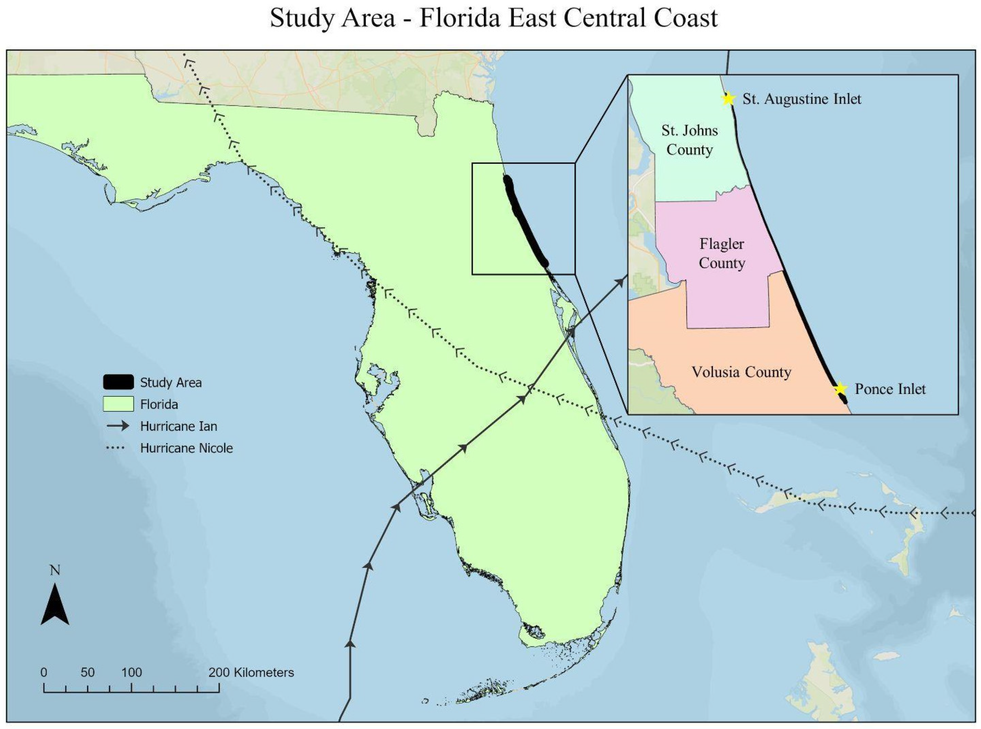
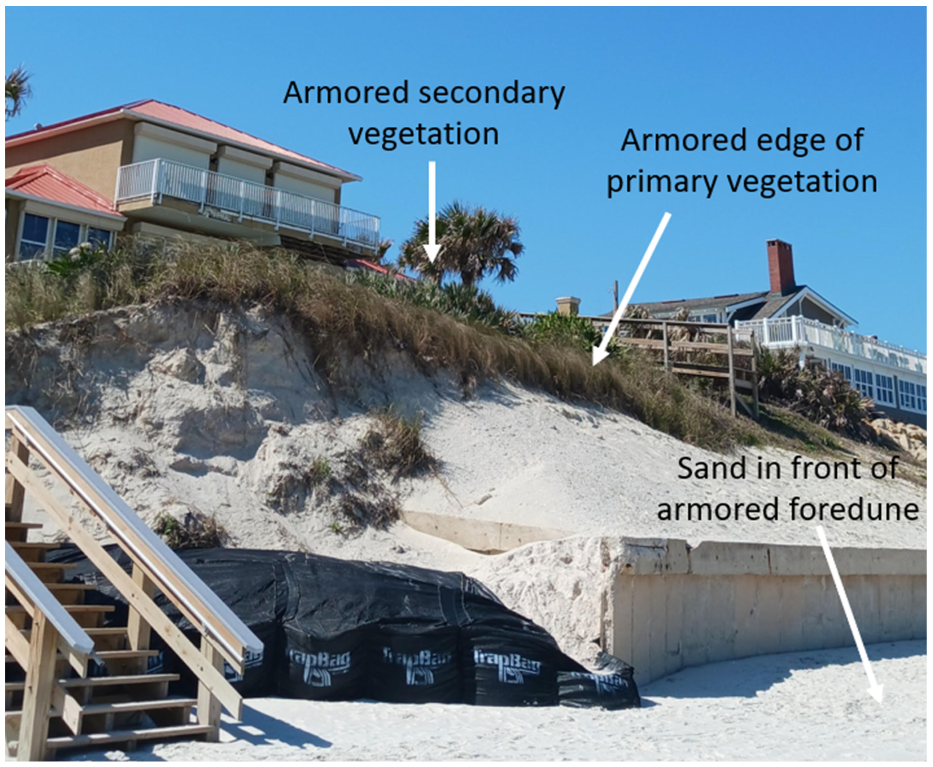
2.1. Study Area and Vegetation Identification
2.2. Planet Data
2.3. LiDAR Data
2.4. LiDAR Data with NDVI
3. Results
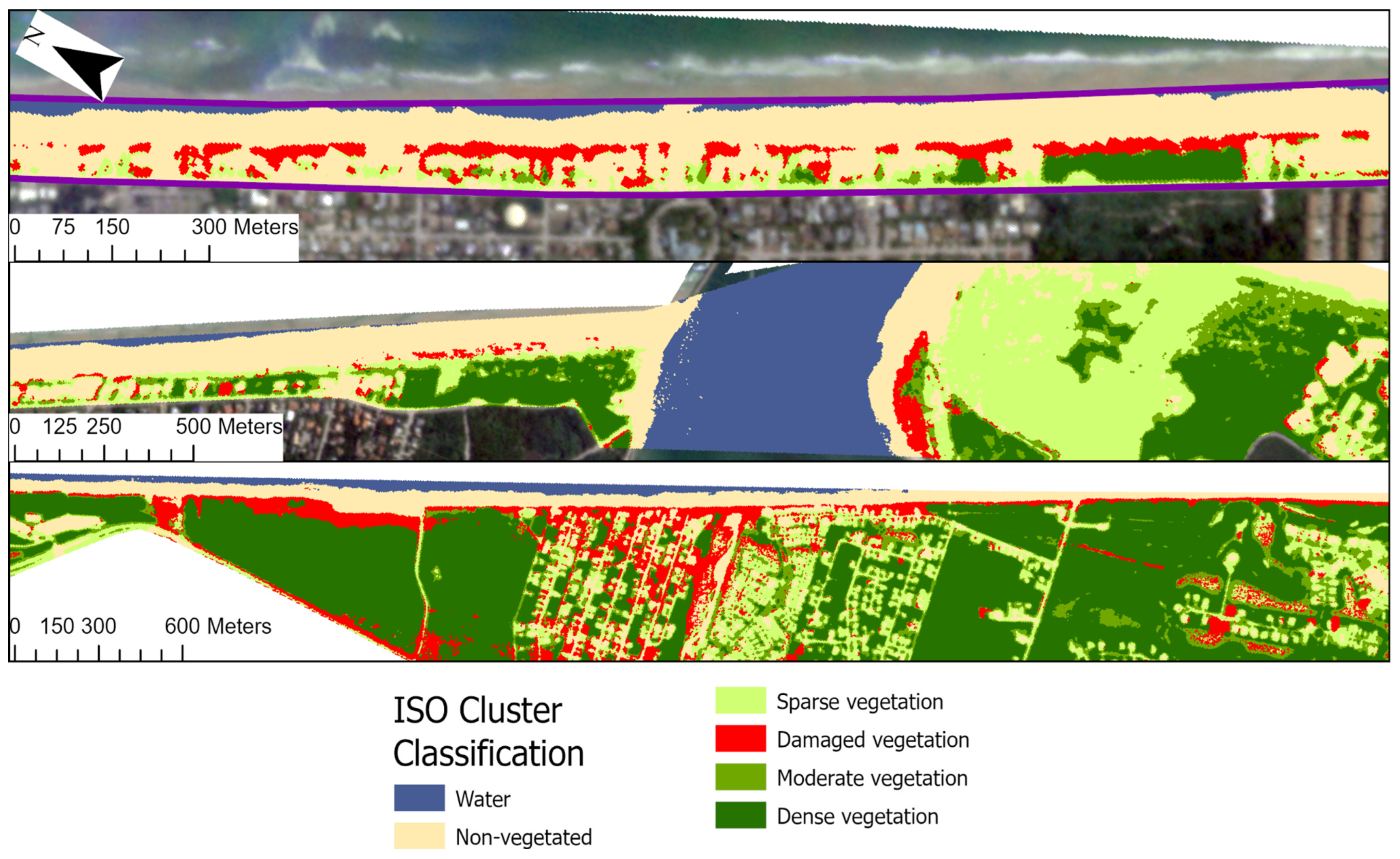
3.1. NDVI Analysis
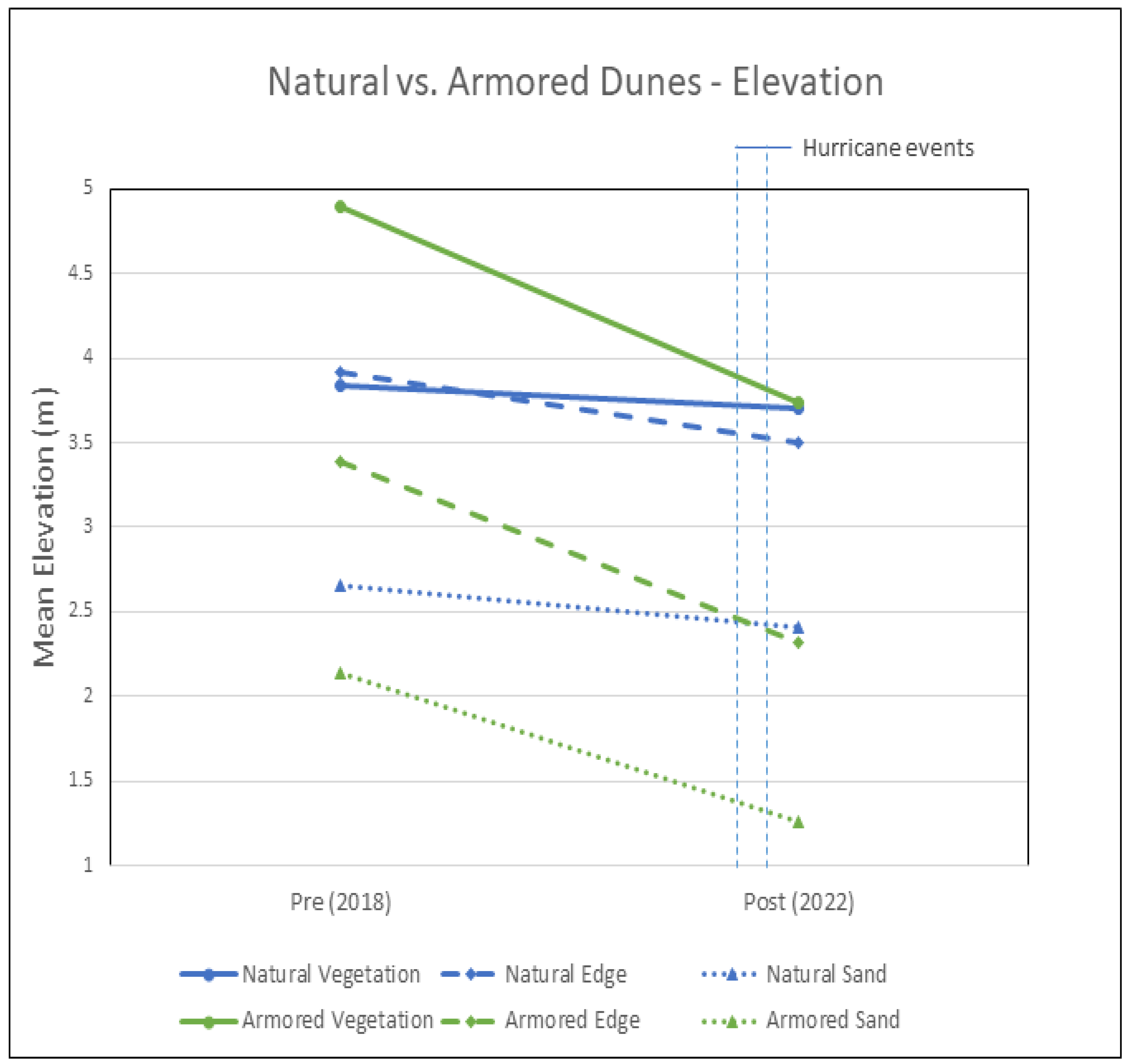
3.2. Impact on Natural vs. Armored Dunes Using LiDAR and NDVI
4. Discussion
5. Conclusions
Author Contributions
Funding
Data Availability Statement
Conflicts of Interest
References
- Marcomini, S.C.; López, R.A. Erosion and management in coastal dunes. Coast. Hazards 2013, 1000, 511–553. [Google Scholar] [CrossRef] [PubMed]
- Goldsmith, V. Coastal sand dunes as geomorphological systems. Proc. R. Soc. Edinb. B 1989, 96, 3–15. [Google Scholar] [CrossRef]
- Leatherman, S.P. Barrier dune systems: A reassessment. Sediment. Geol. 1979, 24, 1–16. [Google Scholar] [CrossRef]
- Dahl, B.E.; Woodard, D.W. Construction of Texas coastal foredunes with sea oats (Uniola paniculata) and bitter panicum (Panicum amarum). Inter J. Biometeor. 1977, 21, 267–275. [Google Scholar] [CrossRef]
- Sigren, J.M.; Figlus, J.; Armitage, A.R. Coastal sand dunes and dune vegetation: Restoration, erosion, and storm protection. Shore Beach 2014, 82, 5–12. [Google Scholar]
- Bessette, S.R.; Hicks, D.W.; Fierro-Cabo, A. Biological assessment of dune restoration in south Texas. Ocean Coast. Manag. 2018, 163, 466–477. [Google Scholar] [CrossRef]
- McGuirk, M.T.; Kennedy, D.M.; Konlechner, T. The role of vegetation in incipient dune and foredune development and morphology: A review. J. Coast. Res. 2022, 38, 414–428. [Google Scholar] [CrossRef]
- Charlier, R.H.; Chaineux, M.C.P.; Morcos, S. Panorama of the history of coastal protection. J. Coast. Res. 2005, 21, 79–111. [Google Scholar] [CrossRef]
- Kisacik, D.; Tarakcioglu, G.O.; Cappietti, L. Adaptation measures for seawalls to withstand sea-level rise. Ocean Eng. 2022, 250, 110958. [Google Scholar] [CrossRef]
- Claudino-Sales, V.; Wang, P.; Horwitz, M.H. Factors controlling the survival of coastal dunes during multiple hurricane impacts in 2004 and 2005: Santa Rosa barrier island, Florida. Geomorphology 2008, 95, 295–315. [Google Scholar] [CrossRef]
- Morton, R.A.; Barras, J.A. Hurricane impacts on coastal wetlands: A half-century record of storm-generated features from southern Louisiana. J. Coast. Res. 2011, 27, 27–43. [Google Scholar] [CrossRef]
- Spiske, M.; Pilarczyk, J.E.; Mitchell, S.; Halley, R.B.; Otai, T. Coastal erosion and sediment reworking caused by hurricane Irma–implications for storm impact on low-lying tropical islands. Earth Surf. Process. Land. 2022, 47, 891–907. [Google Scholar] [CrossRef]
- Takahashi, H.; Zdravković, L.; Tsiampousi, A.; Mori, N. Destabilisation of seawall ground by ocean waves. Géotechnique 2022. ahead of print. [Google Scholar] [CrossRef]
- Brown, H. Creating Resilient Coastlines and Waterways: Hard and Soft Constructions. In Next Generation Infrastructure; Island Press: Washington, DC, USA, 2014; pp. 127–148. [Google Scholar] [CrossRef]
- Malvarez, G.; Ferreira, O.; Navas, F.; Cooper, J.A.G.; Gracia-Prieto, F.J.; Talavera, L. Storm impacts on a coupled human-natural coastal system: Resilience of developed coasts. Sci. Total Environ. 2021, 768, 144987. [Google Scholar] [CrossRef] [PubMed]
- Almarshed, B.; Figlus, J.; Miller, J.; Verhagen, H.J. Innovative coastal risk reduction through hybrid design: Combining sand cover and structural defenses. J. Coast. Res. 2020, 36, 174–188. [Google Scholar] [CrossRef]
- Hosseinzadeh, N.; Ghiasian, M.; Andiroglu, E.; Lamere, J.; Rhode-Barbarigos, L.; Sobczak, J.; Sealey, K.S.; Suraneni, P. Concrete seawalls: A review of load considerations, ecological performance, durability, and recent innovations. Ecol. Eng. 2022, 178, 106573. [Google Scholar] [CrossRef]
- Emanuel, K. The relevance of theory for contemporary research in atmospheres, oceans, and climate. AGU Adv. 2020, 1, e2019AV000129. [Google Scholar] [CrossRef]
- Emanuel, K. The Hurricane—Climate connection. Bull. Am. Meteorol. Soc. 2008, 89, ES10–ES20. [Google Scholar] [CrossRef]
- Knutson, T.; Camargo, S.J.; Chan, J.C.; Emanuel, K.; Ho, C.H.; Kossin, J.; Mohapatra, M.; Satoh, M.; Sugi, M.; Walsh, K.; et al. Tropical cyclones and climate change assessment. Bull. Am. Meteorol. Soc. 2020, 101, E303–E322. [Google Scholar] [CrossRef]
- Xi, D.; Lin, N.; Gori, A. Increasing sequential tropical cyclone hazards along the US East and Gulf coasts. Nat. Clim. Change 2023, 13, 258–265. [Google Scholar] [CrossRef]
- Khanam, M.; Sofia, G.; Koukoula, M.; Lazin, R.; Nikolopoulos, E.I.; Shen, X.; Anagnostou, E.N. Impact of compound flood event on coastal critical infrastructures considering current and future climate. Nat. Hazards Earth Syst. Sci. 2021, 21, 587–605. [Google Scholar] [CrossRef]
- Bucci, L.; Alaka, L.; Hagen, H.; Delgado, S.; Beven, J. Hurricane Ian, National Hurricane Center Tropical Cyclone Report (AL092022). 2023. Available online: www.nhc.noaa.gov/data/tcr/AL092022_Ian.pdf (accessed on 18 February 2024).
- Beven, J.L.; Alaka, L. Hurricane Nicole, National Hurricane Center Tropical Cyclone Report (AL172022). 2023. Available online: https://www.nhc.noaa.gov/data/tcr/AL172022_Nicole.pdf (accessed on 18 February 2024).
- National Centers for Environmental Information (NCEI), Storm Events Database. National Oceanic and Atmospheric Administration (NOAA). 2023. Available online: https://www.ncdc.noaa.gov/stormevents/ (accessed on 7 February 2024).
- Sutton-Grier, A.E.; Wowk, K.; Bamford, H. Future of our coasts: The potential for natural and hybrid infrastructure to enhance the resilience of our coastal communities, economies and ecosystems. Environ. Sci. Policy 2015, 51, 137–148. [Google Scholar] [CrossRef]
- Lemenkova, P. ISO cluster classifier by ArcGIS for unsupervised classification of the Landsat TM image of Reykjavik. Bull. Nat. Sci. Res. 2021, 11, 29–37. [Google Scholar] [CrossRef]
- McKeehan, K.; Arbogast, A. The geography and progression of blowouts in the coastal dunes along the eastern shore of Lake Michigan since 1938. Quat. Res. 2023, 115, 25–45. [Google Scholar] [CrossRef]
- Dewberry. FL Peninsular 2018 Lidar Project—Volusia County; U.S. Geological Survey: Tampa, FL, USA, 2021; p. 23.
- OCM Partners. 2022 USACE FEMA Post Nicole Topobathy Lidar DEM: Florida; NOAA National Centers for Environmental Information. Available online: https://www.fisheries.noaa.gov/inport/item/71753 (accessed on 1 March 2024).
- Gornish, E.S.; Miller, T.E. Effects of storm frequency on dune vegetation. Glob. Change Biol. 2010, 16, 2668–2675. [Google Scholar] [CrossRef]
- Miller, T.E.; Gornish, E.S.; Buckley, H.L. Climate and coastal dune vegetation: Disturbance, recovery, and succession. Plant Ecol. 2010, 206, 97–104. [Google Scholar] [CrossRef]
- Bitton, M.C.; Hesp, P.A. Vegetation dynamics on eroding to accreting beach-foredune systems, Florida panhandle. Earth Surf. Process. Land. 2013, 38, 1472–1480. [Google Scholar] [CrossRef]
- Shiflett, S.A.; Backstrom, J.T. Impacts of Hurricane Isaias (2020) on Geomorphology and Vegetation Communities of Natural and Planted Dunes in North Carolina. J. Coast. Res. 2023, 39, 587–609. [Google Scholar] [CrossRef]
- Florida Natural Areas Inventory. Guide to the Natural Communities of Florida; Florida Natural Areas Inventory: Tallahassee, FL, USA, 1990. [Google Scholar]
- Houser, C.; Hamilton, S. Sensitivity of post-hurricane beach and dune recovery to event frequency. Earth Surf. Process. Land. 2009, 34, 613–628. [Google Scholar] [CrossRef]
- Houser, C.; Wernette, P.; Rentschlar, E.; Jones, H.; Hammond, B.; Trimble, S. Post-storm beach and dune recovery: Implications for barrier island resilience. Geomorphology 2015, 234, 54–63. [Google Scholar] [CrossRef]
- Berry, A.; Fahey, S.; Meyers, N. Changing of the guard: Adaptation options that maintain ecologically resilient sandy beach ecosystems. J. Coast. Res. 2013, 29, 899–908. [Google Scholar] [CrossRef]


| Date(s) | Description |
|---|---|
| 3 December 2021 | Dry season; 9–11 months before hurricanes |
| 28 March 2022 | 6–8 months before hurricanes |
| 2, 6, and 7 October 2022 | After Ian and before Nicole |
| 1, 4, and 6 December 2022 | Dry season; shortly after hurricanes |
| 1 December 2023 | Dry season; 13–15 months after hurricanes |
| NDVI Difference Images | Vegetation Change Description |
|---|---|
| December 2022–December 2021 | Before and after the hurricanes with seasonality-held constant |
| December 2023–December 2022 | Year after hurricanes with seasonality-held constant |
| October 2022–March 2022 | After Hurricane Ian |
| December 2022–October 2022 | After Hurricane Ian and from Hurricane Nicole |
| Cluster | Mean Pre-Storm NDVI December 21 and March 22 | Mean ΔNDVI October 22 to December 22 | % of Study Area | Most Common NLCD Class | Vegetation |
|---|---|---|---|---|---|
| 1 | −0.03 | −0.01 | 6.12 | Water | None |
| 2 | 0.16 | −0.03 | 33.29 | Barren (sand) | Barren |
| 3 | 0.34 | −0.03 | 14.78 | Developed, Medium | Sparse |
| 4 | 0.45 | −0.14 | 5.31 | Developed, Medium | Damaged, possibly from hurricanes |
| 5 | 0.48 | −0.04 | 11.56 | Developed, Medium | Moderate |
| 6 | 0.68 | −0.05 | 28.93 | Evergreen forest | Dense |
| Dune Type | % Change Over Time | ||||
|---|---|---|---|---|---|
| NDVI | Elevation | ||||
| December 2021– December 2022 | December 2022– December 2023 | December 2021– December 2023 | October 2018– December 2022 | ||
| Secondary Vegetation | Natural Dune | −14.29 * | 10.42 * | −5.36 * | −3.65 |
| Armored Dune | −46.34 * | 9.09 * | −41.46 * | −23.67 * | |
| Edge of Primary Vegetation | Natural Dune | −38.71 * | 21.05 * | −25.81 * | −10.71 * |
| Armored Dune | −56.25 * | 14.29 * | −50 * | −31.56 * | |
| Sand | Natural Dune | −26.67 * | 9.09 * | −20 * | −9.40 * |
| Armored Dune | −33.33 * | −10 * | −40 * | −40.85 * | |
Disclaimer/Publisher’s Note: The statements, opinions and data contained in all publications are solely those of the individual author(s) and contributor(s) and not of MDPI and/or the editor(s). MDPI and/or the editor(s) disclaim responsibility for any injury to people or property resulting from any ideas, methods, instructions or products referred to in the content. |
© 2024 by the authors. Licensee MDPI, Basel, Switzerland. This article is an open access article distributed under the terms and conditions of the Creative Commons Attribution (CC BY) license (https://creativecommons.org/licenses/by/4.0/).
Share and Cite
San Antonio, K.M.; Burow, D.; Cho, H.J.; McCarthy, M.J.; Medeiros, S.C.; Zhou, Y.; Herrero, H.V. Data-Driven Assessment of the Impact of Hurricanes Ian and Nicole: Natural and Armored Dunes in the Aftermath of Hurricanes on Florida’s Central East Coast. Remote Sens. 2024, 16, 1557. https://doi.org/10.3390/rs16091557
San Antonio KM, Burow D, Cho HJ, McCarthy MJ, Medeiros SC, Zhou Y, Herrero HV. Data-Driven Assessment of the Impact of Hurricanes Ian and Nicole: Natural and Armored Dunes in the Aftermath of Hurricanes on Florida’s Central East Coast. Remote Sensing. 2024; 16(9):1557. https://doi.org/10.3390/rs16091557
Chicago/Turabian StyleSan Antonio, Kelly M., Daniel Burow, Hyun Jung Cho, Matthew J. McCarthy, Stephen C. Medeiros, Yao Zhou, and Hannah V. Herrero. 2024. "Data-Driven Assessment of the Impact of Hurricanes Ian and Nicole: Natural and Armored Dunes in the Aftermath of Hurricanes on Florida’s Central East Coast" Remote Sensing 16, no. 9: 1557. https://doi.org/10.3390/rs16091557