Skip to Content
You are currently on the new version of our website. Access the old version .

Water

Water is a peer-reviewed, open access journal on water science and technology, including the ecology and management of water resources, published semimonthly online by MDPI.
Water collaborates with the Stockholm International Water Institute (SIWI). In addition, the American Institute of Hydrology (AIH), Polish Limnological Society (PLS) and Japanese Society of Physical Hydrology (JSPH) are affiliated with Water and their members receive a discount on the article processing charges.
Quartile Ranking JCR - Q2 (Water Resources)

All Articles (30,518)

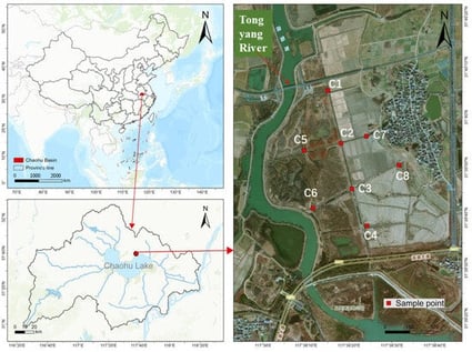
The release of phosphorus (P) from littoral wetland sediments drives eutrophication, with iron (Fe) and sulfur (S) cycles playing key regulatory roles. This study investigated the Tongyang River corridor wetland (Lake Chaohu) in China to elucidate P–Fe–S coupling mechanisms. High-resolution two-dimensional (2D) Diffusive Gradients in Thin-Films (DGT), P-fractionation, and microbial sequencing were employed during wet and dry periods. Results indicated significant total phosphorus (TP) spatial heterogeneity and seasonal available phosphorus (AP) variation. A robust spatial co-variance between DGT-Fe and DGT-P (r > 0.95) reinforces the iron-redox paradigm. However, 2D mapping revealed discretized sub-millimeter “hotspots,” demonstrating that iron (oxyhydr)oxide reductive dissolution is governed by micro-scale niches rather than uniform processes. Microbial analysis further identified summer diversity and Chloroflexi enrichment as primary biological drivers of P mobilization. Specifically, hydrological fluctuations dictate the iron-redox cycle, with wet-period microbial activation serving as the engine for internal P release. These findings suggest that regulating sediment redox conditions across hydrological stages is essential for mitigating wetland eutrophication.

13 February 2026

Geographical location and sedimentary sampling sites. Location of Lake Chaohu in China. The Lake Chaohu Basin with the position of the study area shown. Details of the Tongyang River corridor wetland.

The initiation of debris flows in mountainous areas is dynamically influenced by multiple factors, including rainfall intensity, duration, and antecedent rainfall conditions. Traditional static threshold methods struggle to adapt to these dynamic environmental conditions. To address this issue, this paper proposes a dynamic threshold determination method for the critical rainfall triggering debris flows in mountainous regions. Firstly, high-risk areas are identified based on the frequency ratio model, and the effective rainfall is quantified using the Crozier model. Subsequently, a combination of dynamic variables, such as soil saturation and safety factor, is constructed, and the Jensen–Shannon (JS) divergence is introduced for sensitivity screening to select the most relevant variables. These optimized variables are then fed into an LSTM-TCN (Long Short-Term Memory-Temporal Convolutional Network) framework to extract temporal features and predict the probability of debris flow occurrence time. Finally, real-time threshold determination is achieved by integrating the absolute rainfall energy with a dynamic threshold model. Test results demonstrate that this method can effectively quantify the dynamic nature of rainfall across different regions, screen key variables, and achieve threshold determination with high coverage (average of 0.978) and precise interval width (average of 0.023). This approach provides a more accurate and adaptive means of predicting and managing debris flow risks in mountainous areas, enhancing our ability to respond to these natural hazards in a timely and effective manner.

13 February 2026

Overall structure of probability prediction method for debris flow occurrence time based on LSTM-TCN.

Under dynamic loading (e.g., earthquakes, extreme rainfall), multi-stage slope slumps occur as downstream slopes lose anti-sliding stability, triggering intensive lateral sediment supply that governs mountainous channel evolution. This study uses a coupled CFD-DEM model to simulate how water–sediment conditions regulate sediment transport and riverbed deformation. Results show that during the first sediment supply event, particle motion is initially slower under wet than dry conditions but accelerates due to buoyancy, with the peak average particle velocity along the gully axis decreasing by 11.5% and exhibiting negligible flow rate dependence. In the channel, higher flow rates raise particle velocity and downstream sediment flux, while a prolonged supply interval elevates peak velocity and delays its occurrence. For subsequent events, peak gully axis and vertical velocities increase with sediment supply mass, with weak dependence on flow rate or interval. Post-peak particle motion accelerates with these three factors, enhancing sediment entrainment effects. Increasing flow rate from 1.7 to 2.2 L/s, supply mass from 0.75 to 1.50 kg, and interval from 4 to 6 s significantly strengthens substrate dynamic response, with the peak average velocity rising by 78.3%, 33.3%, 67.0% and maximum displacement by 80.7%, 51.2%, 67.6%, respectively. Channel particle velocity is more sensitive to flow rate but suppressed by greater sediment mass and shorter intervals. The deposited riverbed has three zones: first-supply-dominated, mixed, and subsequent-supply-dominated. Higher flow rates restrict depositional area expansion but increase thickness, whereas greater subsequent sediment expands its dominant zone while reducing thickness, with minimal influence from supply intervals. This study offers theoretical insights for preventing water–sediment disasters in mountainous areas.

13 February 2026

Schematic diagram of the physical model for simulation experiments.

Water and Death: Ecology and Biohistory in the Southeast of Spain

  • María López-Barquero,
  • José-Miguel Abad-González and
  • Ramón García-Marín

This study examines the historical relationship between water management and epidemic diseases in the Region of Murcia (Southeast Spain) between the 16th and 19th centuries. It focuses on two major pathologies—yellow fever and cholera—which, despite differing transmission mechanisms (vector-borne and waterborne, respectively), both depended critically on aquatic and semi-endorheic ecosystems. By analysing archival records, parish death registers, and historical reports of floods and droughts, the paper demonstrates how inadequate hydraulic infrastructure and poor sanitation practices intensified epidemic outbreaks. At least five large-scale epidemic episodes (1804, 1834, 1854, 1865, and 1885) coincided with extreme hydrological events, indicating a clear correlation between water governance failures and mortality peaks. Conversely, periods of effective state intervention through regulation and infrastructure maintenance reveal a marked reduction in disease incidence. The results highlight that water governance was not only a technical challenge but also a socio-political determinant of public health. These historical insights remain relevant today, particularly as climate change exacerbates water-related risks worldwide. Understanding the long-term interactions between ecology, infrastructure, and disease contributes to current debates on environmental resilience and sustainable management of water resources as key components of collective health and social stability.

13 February 2026

Location of the study area. Current mapping of the complex irrigation network in the area known as the Huerta de Murcia (Murcia’s Orchard). Source: Author’s own work.

News & Conferences

Issues

Open for Submission

Editor's Choice

Get Alerted

Add your email address to receive forthcoming issues of this journal.

XFacebookLinkedIn
Water - ISSN 2073-4441