Skip Content
You are currently on the new version of our website. Access the old version .

Remote Sensing

Remote Sensing is an international, peer-reviewed, open access journal about the science and application of remote sensing technology, published semimonthly online by MDPI.
The Remote Sensing Society of Japan (RSSJ) and Japan Society of Photogrammetry and Remote Sensing (JSPRS) are affiliated with Remote Sensing and their members receive discounts on the article processing charge.
Quartile Ranking JCR - Q1 (Geosciences, Multidisciplinary)

All Articles (40,739)

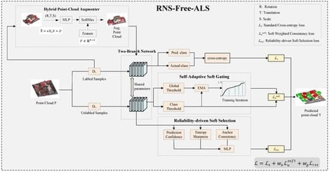
Urban airborne laser scanning (ALS) point clouds cover extensive geographical areas, rendering dense point-level annotation economically prohibitive and limiting the feasibility of fully supervised learning. In weakly supervised settings for urban ALS data, the natural long-tailed class distribution—where ground and building points dominate and smaller objects are rare—combined with the use of fixed pseudo-label thresholds under sparse annotations exacerbates confirmation bias and increases prediction uncertainty. This ultimately restricts the effective utilization of unlabeled data during training. To overcome these challenges, we propose a pseudo-label confidence-calibrated curriculum learning framework designed for weakly supervised ALS point cloud classification. The framework introduces a confidence-aware self-adaptive soft gating (CSS) mechanism that dynamically adjusts category-specific thresholds online using exponential moving average statistics and scene-aware normalization, eliminating the need for manual scheduling while improving pseudo-label quality. In addition, a reliability-driven soft selection (RSS) constraint is incorporated, in which each point is assigned a comprehensive reliability score that integrates prediction confidence, entropy clarity, and cross-augmentation consistency, enabling adaptive soft weighting to replace hard pseudo-label selection and achieve more balanced sample utilization. These components are further integrated into a unified pseudo-label confidence-calibrated curriculum learning framework (P3CL) that progressively shifts the model’s focus from high-certainty samples to more ambiguous ones, effectively mitigating confirmation bias. Extensive experiments on three public ALS benchmarks demonstrate that the proposed method consistently outperforms existing weakly supervised approaches and achieves competitive performance compared with several fully supervised models.

9 February 2026

Framework of P3CL.

Building polygon extraction is a critical task in remote sensing analysis and a fundamental component of modern urban management. Conventional segmentation-based methods often suffer from geometric distortions during the conversion from masks to polygons. End-to-end polygon prediction approaches (e.g., PolyWorld) alleviate this issue by directly predicting building polygons; however, existing PolyWorld-like methods remain limited in accurate corner vertex detection and polygon reasoning due to insufficient representation learning, particularly for geometry. In this work, we propose PolyGeom, an end-to-end framework equipped with a geometry-aware graph transformer for accurate and robust building polygon extraction. PolyGeom employs the Segment Anything Model (SAM) as its backbone to leverage large-scale pretrained features, thereby capturing both local and global semantics. Moreover, we propose a geometry-aware graph transformer that explicitly models geometry of building polygons, facilitating more reliable polygon reasoning. Extensive experiments on three challenging benchmarks, CrowdAI, WHU, and BONAI datasets, demonstrate that PolyGeom consistently outperforms existing methods in terms of building detection accuracy, topology correctness, and geometry alignment. Ablation studies further validate the effectiveness of the two key proposed designs in building polygon extraction.

9 February 2026

Overall architecture of PolyGeom. PolyGeom consists of three modules: (1) a vertex detection module that takes a remote sensing image as input and outputs candidate building corners with their positions and visual descriptors; (2) a vertex aggregation module that treats the detected corners as graph vertices and performs message passing to produce matching descriptor; and (3) an edge prediction module that infers vertex connectivity, yielding a connection matrix. The final building polygons are formed by these detected vertices (red points) and predicted edges (blue lines).

The precise localization of small objects in UAV-captured remote sensing imagery remains a formidable challenge due to their limited spatial support, coarse resolution, and severe background clutter. These factors often cause weak target cues to be progressively overwhelmed during deep feature extraction. Existing deep learning-based detectors typically suffer from two fundamental limitations: the irreversible loss of fine-grained spatial details during hierarchical feature fusion and the scale-insensitive optimization of conventional loss functions, which inadequately emphasize hard-to-detect small targets. To address these issues, we propose a novel Spatial-Semantic Aggregation and Balancing Network (SSABNet) tailored for UAV-based small-target detection. First, a Spatial-Semantic Aggregation (SSA) module is introduced to establish a high-fidelity restoration pathway that recovers fine-grained texture and boundary information from shallow layers. By employing content-aware operators, SSA effectively reconciles the structural discrepancy between spatial details and semantic abstractions, enabling precise cross-scale feature fusion while suppressing aliasing artifacts. Second, we design a Scale-Aware Balancing Loss (SABL) to mitigate the gradient instability and vanishing-gradient issues commonly encountered when optimizing non-overlapping small targets. SABL adopts a scale-dependent modulation mechanism that smoothly transitions from Wasserstein distance for distributional alignment of small objects to Euclidean distance for geometric refinement of larger targets, thereby ensuring stable and balanced optimization across object scales. Extensive experiments on the VisDrone benchmark demonstrate that SSABNet outperforms state-of-the-art detectors, achieving gains of 1.3% in overall AP and 2.5% in APs. Further evaluation on the UAVDT dataset confirms its strong generalization capability, yielding improvements of 0.5% in AP and 16.9% in APs. These results validate the effectiveness of jointly addressing feature representation and scale-aware optimization for UAV small-target detection.

9 February 2026

Representative UAV remote sensing images from the VisDrone datasets. Objects of interest, such as vehicles and pedestrians, often occupy fewer than 
  
    32
    ×
    32
  
 pixels and are embedded in highly cluttered backgrounds. The combination of nadir viewing perspectives, dense object distributions, and limited spatial resolution highlights the inherent difficulty of small-target detection in UAV scenarios.

This study investigates the spatiotemporal variability of ambient methane (CH4) using a drone-deployable Aeris Technologies MIRA Strato LDS midwave-infrared analyzer. Laboratory calibration with NOAA-certified gas standards and Standard Reference Material (SRM) for CH4 demonstrated high measurement precision across a range of concentrations (R2 = 0.9986, slope = 0.9678). Field validation conducted during a two-week intercomparison with a Picarro G2301 in September 2023 confirmed the MIRA Strato’s reliability under ambient conditions (R2 = 0.9845; slope = 0.9438), indicating strong agreement with the reference analyzer. Diurnal patterns revealed peak CH4 concentrations (~2.2 ppm) between 04:00–08:00 LT and minima (~2.1 ppm) between 13:00–17:00 LT, consistent with nocturnal boundary-layer stability and daytime convective mixing. Across 14 midday UAV flights from October 2023 to September 2024, CH4–altitude slopes ranged from −3.05 × 10⁻⁴ to +1.41 × 10⁻⁴ ppm/m, reflecting variable stratification and uplift regimes. The highest flight concentration (2.23 ppm) was observed on 19 October under stable conditions, while the lowest (2.03 ppm) was observed on 14 August under elevated vertical mixing. These extremes reflect seasonal background accumulation and convective transport effects. Temperature was the most consistent predictor, with regression coefficients ranging from −0.021 to +0.008 ppm/°C, while ethane (C2H6) coefficients were significant but confounded due to measurements below detection limits. The analyzer maintained strong signal stability throughout (mean CV ≈ 0.0066; max = 0.0114), and remote sensing validation with TROPOMI supported observed seasonal accumulation trends. These results demonstrate the MIRA Strato’s capability to resolve near-surface CH4 dynamics and characterize convective transport in complex atmospheric environments.

9 February 2026

HUBC ground-based testing facility. From the Howard University Beltsville Research Center.

News & Conferences

Issues

Open for Submission

Editor's Choice

Reprints of Collections

Advanced Multi-GNSS Positioning and Its Applications in Geoscience
Reprint

Advanced Multi-GNSS Positioning and Its Applications in Geoscience

Editors: Ahao Wang, Yize Zhang, Xuexi Liu, Xiangdong An, Junping Chen

Get Alerted

Add your email address to receive forthcoming issues of this journal.

XFacebookLinkedIn
Remote Sens. - ISSN 2072-4292