- Article

Multi-Scale Analysis of Ecosystem Service Trade-Off Intensity and Its Drivers Based on Wavelet Transform: A Case Study of the Plain–Mountain Transition Zone in China
- Congyi Li,
- Penggen Cheng and
- Zhanhui Zhao
- + 3 authors
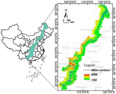
Identifying the multi-scale drivers of ecosystem service (ES) trade-off intensity is essential for promoting regional sustainability. However, the existing multi-scale ES studies typically rely on predefined administrative units or fixed grid sizes due to the absence of scientifically sound scale-partitioning approaches, which limits the identification of characteristic scales and obscures scale-dependent interactions. This study broke new ground by combining continuous wavelet transform (CWT) and optimal parameter geographic detector (OPGD) to automatically identify the characteristic scales of trade-offs between ecosystem services, thus opening up a new avenue in multi-scale studies. Taking China’s plain–mountain transition zone as a case study, we evaluate trade-off intensity among four key ecosystem services—water yield (WY), habitat quality (HQ), soil conservation (SC), and carbon storage (CS). The results show that the following: (1) The identification of 36 characteristic scales (ranging from 5 km to 55 km) indicates that ecosystem service trade-offs operate across a wide range of spatial extents, implying that a single management scale cannot effectively address all ES interactions. (2) From 2000 to 2020, CS-HQ, SC-HQ, and WY-HQ trade-off intensities were jointly driven by both natural conditions and human activities, whereas CS-SC was predominantly influenced by natural and climatic factors. The trade-off intensities between CS-WY and WY-SC were mainly controlled by climatic forces. (3) The explanatory power (q value) of each factor varied distinctly with spatial scale, and the interaction effects between multiple factors were substantially stronger than their individual effects. This indicates that ecosystem service trade-offs are primarily governed by coupled processes rather than isolated drivers. Consequently, management strategies targeting single drivers are unlikely to be effective. Instead, ecosystem management should be designed around combinations of drivers that operate at specific spatial scales and provide a concrete pathway for translating trade-off analyses into spatially differentiated management actions.
7 February 2026