Skip to Content

Hydrology

Hydrology is an international, peer-reviewed, open access journal on hydrology published monthly online by MDPI.
The American Institute of Hydrology (AIH) and Japanese Society of Physical Hydrology (JSPH) are affiliated with Hydrology and their members receive discounts on the article processing charges.
Quartile Ranking JCR - Q2 (Water Resources)

All Articles (1,677)

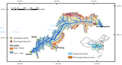
The Three Gorges Reservoir (TGR) in China is one of the world’s largest hydropower projects. Interval inflow, originating from ungauged areas between the upstream gauging control stations (Zhutuo, Beibei, Wulong) and the TGR dam site, is a critical component of total reservoir inflow, but its hydrological characteristics have not been fully clarified. The accurate estimation and prediction of interval inflow are essential for reservoir safety and flood control operations. Using daily hydrological data from 2009 to 2017, we propose an integrated analytical framework combining (i) flow travel time estimation using cross-correlation analysis, (ii) multi-scale statistical characterization, and (iii) K-means clustering with bootstrap validation and algorithm comparison. This framework systematically identified hydrological regimes of interval inflow and their associated flood control risks. The key findings are as follows. (1) The optimal flow travel time from the upstream gauging stations to the dam site is 1 day (correlation coefficient ), and it remains stable across different flow regimes. (2) The interval inflow exhibited a highly right-skewed distribution (mean 1279 m3/s, standard deviation 1651 m3/s) and contributed on average 10.1% to the total inflow. The contribution ratio exhibited an inverted U-shaped relationship with increasing total inflow, peaking at 11.4% when the total inflow (Q) was 13,014 m3/s. The quartile thresholds were 5788 m3/s, 9575 m3/s, and 16,869 m3/s (corresponding to Q1, Q2, and Q3, respectively), and the 10th and 90th percentiles (P10 and P90) were 4865 m3/s and 24,625 m3/s, respectively. (3) Five distinct hydrological patterns (C1–C5) were successfully identified, among which Cluster C4 (5.7% of days) was defined as the high-impact pattern based on reservoir operational criteria, with a mean I of 6425 m3/s, a mean R of 27.8% (up to 44% in extreme events), a mean flood duration of 5.8 days, a mean flood volume of 36.1 × 10⁸ m3, and a flashiness index of 1.48. (4) C4 is predominantly triggered by localized heavy rainfall, and its flashy nature implies a substantially shorter forecast lead time compared with mainstream-dominated floods, posing major challenges to real-time reservoir operations. This study demonstrates that interval inflow risk is pattern-dependent and that the proposed framework provides a scientific basis for developing pattern-specific reservoir operation strategies. The proposed framework is transferable to other large river-type reservoirs facing similar ungauged interval inflow challenges.

23 February 2026

Distribution map of the water system and hydrological stations in the TGR area.

Drought is expected to intensify under climate change, posing significant risks to Mediterranean agroecosystems. This study provides long-term projections of drought and wetness conditions for three representative Mediterranean regions—Eastern Mancha (Spain), Sidi Bouzid Governorate (Tunisia), and the Beqaa Valley (Lebanon)—to support climate-resilient planning. Future monthly precipitation (2020–2050) was dynamically downscaled using the Weather Research and Forecasting (WRF) model under the RCP4.5 scenario, and the Standardized Precipitation Index (SPI12) was subsequently applied to quantify drought severity at annual and monthly scales. By integrating dynamically downscaled WRF projections with pixel-based SPI analysis across three spatially distinct Mediterranean regions, the study provides a novel, spatially explicit and comparative framework for assessing future drought and wetness extremes in support of climate-resilient planning. The results reveal spatial variability and moderate temporal fluctuations across the three regions, reflected in differing timings and intensities of their driest and wettest hydrological years. Spain is projected to experience its driest hydrological year in 2046–2047, Tunisia in 2030–2031, and Lebanon in 2047–2048. The wettest years are projected to occur in 2045–2046 for Spain and Tunisia, and in 2028–2029 for Lebanon. Although extreme drought events are not widely anticipated, localised severe dry periods emerge in many parts of the study areas. while in Lebanon, these conditions also extend into the winter and spring. These findings underscore the need for spatially targeted adaptation rather than uniform regional measures. Identifying both driest and wettest projected years enhances preparedness, informs water-resource optimisation, and supports agricultural land-use planning, especially in areas with favourable future climatic conditions. Integrating drought projections into multi-hazard planning (i.e., drought and floods) frameworks can further strengthen territorial resilience in regions facing increasing climate-related extremes.

15 February 2026

Spatial extent of the three study areas (a) Eastern Mancha (Spain), (b) Sidi Bouzid (Tunisia), and (c) the Beqaa Valley (Lebanon) and (d) their overall distribution across the Mediterranean region.

Groundwater, a vital resource for drinking water supply, must be managed sustainably to ensure its availability and quality. In France, the SISE-Eaux database on water intended for human consumption, archived by the Regional Health Agencies (ARS) since 1990, constitutes a rich source of information. This study focused on the groundwater of the Nouvelle-Aquitaine region, the largest administrative region in metropolitan France, covering 84,061 km2 with 6 million inhabitants. It is based on a 22-year data extraction, resulting in a matrix of 121,649 observations and 51 physico-chemical and bacteriological parameters. Following logarithmic transformation of the data and fitting of variograms using the mean value of each parameter for each sampling point, the spatial distribution of numerous parameters across the region is presented. From this initial sparse matrix, a dense matrix of 23,319 samples (rows) and 15 key parameters (columns) was selected for a multivariate approach. A Principal Component Analysis (PCA) was used to condense the information and create summary maps capturing over 68% of the information contained in the dense matrix. The combined results of the multivariate analysis (dense matrix) and the distribution of individual parameters (sparse matrix) highlight the diversity of sources contributing to the spatial variability of groundwater, such as the role of lithology, the origin and pathways of fecal contamination, and the influence of redox processes. Neither the large size of the study area nor the high number of parameters proved to be an obstacle to the analysis. The understanding of ongoing processes and the factorial axis distribution maps, which enable the spatial representation of these mechanisms, can be used to facilitate groundwater monitoring and protection.

14 February 2026

(a) Location and main physical characteristics of the Nouvelle Aquitaine region; (b) simplified geological map of the Nouvelle Aquitaine region (UTM coordinates in m; (c) Simplified geological cross-section (blue line on (b)) from the Paris Basin to the Gironde (adapted from BRGM, https://www.brgm.fr/fr/implantation-regionale/nouvelle-aquitaine, accessed on 1 January 2025, and AGSO-AGBP, https://www.agso.net/sites/agso.net/IMG/pdf/livret_guide_seuil_poitou.pdf, accessed on 11 November 2025).

The determination of groundwater background levels is a prerequisite for assessing and analyzing groundwater characteristics. Shanghai is among the most economically developed regions in China and is located in the estuary of the Yangtze River, where frequent hydrogeochemical processes occur. Moreover, the frequency of anthropogenic activities in Shanghai is very high. Consequently, assessing groundwater background levels in Shanghai is inherently limited if only statistical methods are adopted or anthropogenic impacts are ignored. In this study, hydrochemical and statistical methods were coupled to identify groundwater anomalies and background levels. The results revealed distinct differences in hydrochemical characteristics between the two selected independent units (Chongming and Qingpu units), highlighting the necessity of reasonably delineating hydrogeological units for obtaining background values. Furthermore, for these two independent units, different optimal methods for identifying and eliminating anthropogenic groundwater anomalies were determined. The use of coupled methods was demonstrated to be substantially superior to the use of purely statistical approaches. Hydro-HCA was identified as the optimal identification method for the Chongming unit, whereas Hydro-Grubbs was determined as the most suitable method for the Qingpu unit. This could be attributed mainly to the coupled methods accounting for not only the dispersion of the data itself but also the intrinsic relationships and evolutionary processes of hydrochemical components. These findings could provide reliable information for subsequent groundwater background surveys and studies on groundwater pollution characteristics in Shanghai and to guide future endeavors aimed at protecting groundwater resources.

12 February 2026

Study area location and distribution of sampling sites in Shanghai. The reframes represented the selected research areas.

News & Conferences

Issues

Open for Submission

Editor's Choice

Get Alerted

Add your email address to receive forthcoming issues of this journal.

XFacebookLinkedIn
Hydrology - ISSN 2306-5338