Skip Content
You are currently on the new version of our website. Access the old version .

Hydrology

Hydrology is an international, peer-reviewed, open access journal on hydrology published monthly online by MDPI.
The American Institute of Hydrology (AIH) and Japanese Society of Physical Hydrology (JSPH) are affiliated with Hydrology and their members receive discounts on the article processing charges.
Quartile Ranking JCR - Q2 (Water Resources)

All Articles (1,667)

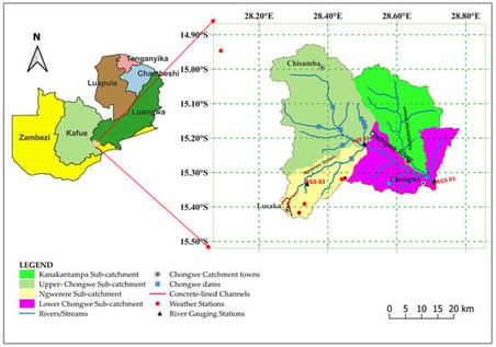
Rapid urbanization has led to increasing structural modification of river catchments through dam construction and concrete-lining of natural channels as flood management measures. These interventions can alter the natural hydrology. This necessitates assessment of their influence on hydrology at a catchment scale. However, such evaluations are particularly challenging in data-scarce regions such as the Chongwe River Catchment, where hydrometric records capturing conditions before and after structural modifications are limited. Therefore, we applied a 2D rain-on-grid approach in HEC-RAS to evaluate changes in high-flow responses to short-duration, high-intensity rainfall events in the Chongwe River Catchment in Zambia, where structural interventions have been implemented. The terrain was modified in HEC-RAS to represent 21 km of concrete drains and ten dams. Sensitivity analysis conducted on five key model parameters showed that parameters controlling surface runoff generation, particularly curve number, exerted the strongest influence on simulated peak flows, while routing-related parameters had a secondary effect. Model calibration and validation showed strong performance with R2 = 0.99, NSE = 0.75 and PBIAS = −0.68% during calibration and R2 = 0.95, NSE = 0.75, PBIAS = −2.49% during validation. Four scenarios were simulated to determine the hydrological effects of channel concrete-lining and dams. The results showed that concrete-lining of natural channels in the urban area increased high flows at the main outlet by approximately 4.6%, generated localized instantaneous maximum channel velocities of up to 20 m/s, increased flood depths by up to 11%, decreased lag times and expanded flood inundation widths by up to 15%. The existing dams reduced peak flows by about 28%, increased lag times, reduced flood depths by about 11%, and reduced flood inundation widths by up to 8% across the catchment. The findings demonstrate that enhancing stormwater conveyance through concrete-lining must be complemented by storage to manage high flows, while future work should explore nature-based solutions to reduce channel velocities and improve sustainable flood mitigation. Therefore, the study provides event-scale insights to support flood-risk management and infrastructure planning in rapidly urbanizing, data-scarce catchments.

6 February 2026

Location of the Chongwe River Catchment in Zambia showing sub-catchments, drainage features including rivers, concrete-lined channels and dams, as well as the locations of weather stations, river gauging stations and major towns.

With 2024 marking the tenth anniversary of its establishment, 2025 was the first year of the second decade of Hydrology [...]

6 February 2026

Climate change can alter both the amount and timing of inflows to water supply reservoirs while also increasing heat-driven demand and the likelihood of stressful warm-season conditions. Climate-driven changes in inflow to Eagle Mountain Lake Reservoir (Texas, USA) were quantified by integrating (i) a calibrated SWAT model evaluated at four USGS stream gauges, (ii) statistically downscaled CMIP6 daily precipitation and minimum/maximum temperature at seven stations/grid points for a historical baseline (2003–2022) and two future windows (2031–2050 and 2081–2100) under SSP1-2.6, SSP2-4.5, and SSP5-8.5, and (iii) observed reservoir operations (lake level, water supply releases, and flood discharge; 1990–2022). A standard watershed climate workflow is reframed through an operations-focused lens, wherein projected inflow changes are translated into decision-relevant indicators via the utilization of observed thresholds and operating mode signals. Included within this framework are spring refill-season inflow shifts, a hot–dry month metric, and storage threshold performance measures, which are coupled with screening-level probabilities linked to multi-year inflow deficits. Across models and stations, mean annual temperature increases by 0.7–1.9 °C in the 2030s and by 0.7–6.1 °C in the 2080s, while annual precipitation changes remain uncertain (−24% to +55%). Daily projections show a strong increase in extreme heat days (daily Tmax above the historical 95th percentile), from about 18 days yr−1 historically to about 30–33 days yr−1 in the 2030s and about 34–82 days yr−1 by the 2080s. Hot–dry months (monthly mean Tmax above the historical 90th percentile and monthly precipitation below the historical median) increase modestly by mid-century and rise to about 1.5 months yr−1 on average by the 2080s under SSP5-8.5. SWAT simulations indicate that the mean annual inflow declines by 17–20% across scenarios, with the largest reductions during the spring refill period (March–June). Historical operations show that hot–dry months are associated with approximately double the mean water supply release (7.2 vs. 3.5 m3/s) and a lower monthly minimum lake level (about 0.30 m; about 1.0 ft lower on average). Flood discharges occur almost exclusively when lake elevation is at or above about 197.8 m and follow multi-day rainfall clusters (cross-validated AUC = 0.99). Together, these results indicate that earlier-season inflow reductions and more frequent hot–dry stress will tighten the operational margin between refill, summer demand, and flood management, underscoring the need for adaptive drought response triggers and integrated drought–flood planning for the Dallas–Fort Worth region.

6 February 2026

Reaction of Minimum Streamflow of Arid Kazakhstan Rivers to Climate Non-Stationarity

  • Marat Moldakhmetov,
  • Lyazzat Makhmudova and
  • Harris Vangelis
  • + 7 authors

This article provides a comprehensive analysis of long-term changes in the minimum river flow of the southern rivers of Western Kazakhstan (Temir, Oiyil, Zhem) for the period 1940–2022, with an emphasis on summer minimum and winter low flow as key indicators of water and environmental sustainability in conditions of increasing climate variability. The study combines a typology of the climate control mechanisms of minimum flow, analysis of structural homogeneity, and assessment of the internal organization of time series based on ITA and the integral IPTA method, which allow us to reveal the hidden fluctuations and stable phase states of the hydrological regime. The calculation of the climate sensitivity index (CSImin) showed pronounced seasonal asymmetry: summer runoff is largely controlled by atmospheric precipitation, while winter minimum runoff is determined by temperature regime and soil freezing depth. Parametric and nonparametric tests (Pettitt, ADF, SNHT) revealed significant structural shifts in the 1960s–1990s period, corresponding to large-scale climatic anomalies in the region. Summer series are characterized by phases of prolonged low water levels and negative trends in the mid-20th century, while for the winter period, a steady increase in minimum flow has been established, due to regional warming and an increase in the share of underground recharge. IPTA confirmed the presence of long-term phases with high internal heterogeneity in the summer season and a more stable winter runoff structure. The results demonstrate the high climatic sensitivity of minimum runoff and confirm the need to move from static standards to dynamically adaptable methods of water resource assessment. The proposed approach can serve as a tool for developing adaptation strategies, assessing the risk profile of basins, and improving the sustainability of water management planning in arid regions.

5 February 2026

News & Conferences

Issues

Open for Submission

Editor's Choice

Get Alerted

Add your email address to receive forthcoming issues of this journal.

XFacebookLinkedIn
Hydrology - ISSN 2306-5338