Skip to Content
You are currently on the new version of our website. Access the old version .

Geotechnics

Geotechnics is an international, peer-reviewed, open access journal on geotechnical engineering published quarterly online by MDPI.

All Articles (324)

Role of Soil Erosion in Instability of Slopes Along Coastal Karnataka

  • Asha U. Rao,
  • Narayana Sabhahit and
  • Radhika P. Bhandary
  • + 1 author

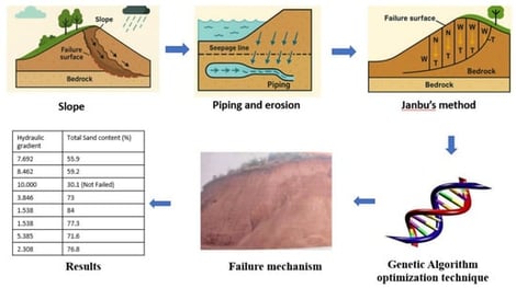
The laterite formations consist of top layers that are highly porous, followed by a lithomargic soil layer over the weathered residual soil and parent rock. The excavated slopes are stable during summer, but the slopes with exposed lithomargic soils have failed during rainy season even when safety factor was more than one. The present study considers the effect of erosion in the lithomargic layer of soil while analyzing the stability of slopes. Janbu’s GPS (Generalized Procedure of Slices) method in conjunction with a genetic algorithm is used to analyse the slope stability and to locate the noncircular critical slip surface. A failed slope from the Yekkur site was considered for the study considering three possible failure mechanisms (Mechanism I, II and III) of slopes due to progressive erosion of fines in the lithomargic soil layer. It is observed that the lithomargic soil’s vulnerability to erosion depends on a critical combination of sand content and hydraulic gradient causing piping. Mechanism III is more critical as compared to other mechanisms and a similar observation was made from failed slopes in the field. The failure in lateritic soil slopes is mainly due to piping of lithomargic soil, which reduces the length of the critical slip surface, and failure due to erosion is progressive.

11 February 2026

Various failure mechanisms (a) Failure Mechanism I. (b) Failure Mechanism II, (c) Failure Mechanism III.

This study investigates how incorporating physical constraints can enhance the performance of machine learning models by ensuring that geotechnical drilling data predictions align with known physical conditions at the site. Machine learning-predicted soil property point cloud data has significant value for geotechnical project planning. The base model was trained on extensive borehole datasets of soil properties collected from an area of 32,133 square km covering five distinct physiographical regions. To incorporate physics-based constraints, a custom loss function was defined to penalize the model training loss whenever it violates known physical principles. Two distinct types of machine learning models—classification and regression models—are considered in this study for categorical and numerical geotechnical drilling datasets, respectively. Feature variables play a critical role in determining the accuracy of machine learning models and feature variables including location, geology, surface elevation, soil parent material, physiographical information (codes) and soil layer depth are adopted for training the machine learning models after parametric study of various feature variable combinations. Two case studies were conducted to demonstrate the effectiveness of incorporating physical constraints into machine learning models for categorical and regression datasets respectively. The study results demonstrate strong potential for applying physics-constrained machine learning models to generate reasonable estimated values across large regions, while also providing a better understanding of the historical data within the geotechnical drilling inventory.

10 February 2026

Soil type (grain size) data used for machine learning model training: (a) spatial distribution (top view); (b) data distribution histogram.

Lateral pressure on a retaining wall could be a critical parameter that affects the stability and efficiency of the wall design. Traditional methods to estimate active lateral earth pressure is often inadequate in cases where geometric constraints, or arching effects play significant roles. An analytical method has been used in this study to estimate soil and geotextile stresses in reinforced retaining walls by considering the arching effect. It presents a clear analytical solution for calculating lateral earth pressure in narrow Mechanically Stabilized Earth (MSE) walls. The model includes bilinear failure surfaces and nonlinear stress paths, which better reflect real soil behavior in comparison to the traditional methods with linear failure surfaces. The proposed method demonstrated excellent agreement with both field data and centrifuge test results. According to the proposed analytical approach, the distribution of horizontal soil pressure is not linear. The lateral soil pressure is zero at the top and bottom, while the maximum pressure is between 0.4 and 0.9 of the wall height. The formulation further indicates that the higher the friction at the interfaces, the greater the arching effect, so reducing the lateral earth pressure on the retaining wall. Moreover, narrowing the backfill space leads to a significant reduction in lateral earth pressure.

9 February 2026

Failure surface shape.

A three-dimensional discrete element method (DEM) framework was developed and applied to investigate the time-domain seismic response of a soil–pier system embedded in stratified dry sand. The numerical model was validated against analytical solutions to determine the ultimate vertical load capacity and internal forces when subjected to a lateral load at the pier head. Simulations were conducted to explore the influence of different excitation frequencies and amplitudes on soil–foundation interaction. Dynamic p–y curves were extracted at multiple elevations along the shaft to examine variations in lateral stiffness with depth. The results show that seismic loading significantly increases lateral displacement, and the residual response is strongly governed by the input motion amplitude. Peak lateral deformation and internal forces were observed when the excitation frequency coincided with the pier’s natural frequency. Both cyclic shear strain and ground settlement reached their maximum near the natural frequency of the soil deposit, and increased substantially with shaking amplitude.

5 February 2026

Schematic plan view of the soil–pier system.

News & Conferences

Issues

Open for Submission

Editor's Choice

Get Alerted

Add your email address to receive forthcoming issues of this journal.

XFacebookLinkedIn
Geotechnics - ISSN 2673-7094