- Article

A Quantitative Assessment of the Inconsistency Between Waterbody Segmentation and Shoreline Positioning in Deep Learning Models
- Wei Wang,
- Boyuan Lu and
- Fujiang Ji
- + 1 author
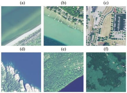
Accurate shoreline positioning is critical for coastal monitoring and management, yet deep learning shoreline products are often evaluated using conventional waterbody segmentation metrics that do not explicitly measure boundary alignment. Using 20,689 NAIP aerial images covering the Great Lakes shoreline from the Coastal Aerial Imagery Dataset (CAID), we benchmark five semantic segmentation models and quantify the inconsistency between image-level segmentation accuracy (pixel accuracy, IoU) and shoreline positioning accuracy measured by the Shoreline Intersection Ratio (SIR) and Average Eulerian Distance (AED). Although segmentation performance is consistently high (pixel accuracy typically >98% and IoU often >90%), shoreline agreement is substantially lower and strongly landscape-dependent, with the poorest results in wetlands and urban scenes. Correlation analyses across coastal types and water-surface conditions show that the correspondence between segmentation metrics and SIR varies with shoreline morphology. Multivariate regressions confirm the shoreline-to-water ratio (SWR) as the dominant predictor of both SIR and AED, while shoreline complexity (SCI) and mean water hue (MWH) have weaker, context-dependent effects. These results demonstrate that high segmentation accuracy does not guarantee precise shoreline delineation and motivate shoreline-aware evaluation protocols.
16 February 2026