Skip Content
You are currently on the new version of our website. Access the old version .

GeoHazards

GeoHazards is an international, peer-reviewed, open access journal on theoretical and applied research across the whole spectrum of geomorphological hazards, namely endogenous and exogenous hazards, as well as those related to climate change and human activity, published quarterly online by MDPI.

All Articles (256)

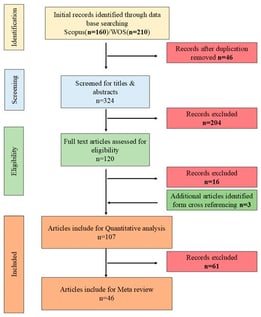
This paper presents a systematic review of research investigating the effects of elevated temperatures on sedimentary rocks. The literature was selected using keyword-based searches of titles, abstracts, and keywords in the Scopus and Web of Science databases. In total, 107 relevant articles published between 2010 and 2024 were critically examined to address research questions on temperature-treated sedimentary rocks. Furthermore, both bibliometric analysis and systematic synthesis of experimental data were performed. The review identifies sandstone as the most-studied rock type, followed by limestone. It reveals that standard experimental methods include unconfined compressive strength (UCS), Brazilian tensile strength (BTS), and P-wave velocity tests. The study’s findings indicate that a temperature threshold of 400–600 °C governs deterioration in engineering properties, driven by the quartz α–β transition in sandstones and calcite decomposition in limestones. Normalized data show that UCS, BTS, and elastic modulus decline significantly beyond this threshold, while porosity increases. The study highlights the influence of fabric anisotropy, mineralogy, and heating conditions on rock behaviour, and identifies research gaps related to confined testing, real-fire scenarios, and anisotropic rocks. Based on a comprehensive analysis of the literature, the principal factors and processes occurring at different temperature ranges were identified and discussed.

1 February 2026

Article screening process based on the PRISMA protocol, including identification, screening, eligibility, and inclusion.

Uranium production tailing ponds in Kamyanske (Ukraine) are objects of increased radioecological danger. Violation of the stability and integrity of containment dams threatens the uncontrolled spread of radionuclides. The purpose of this study is to comprehensively assess the factors affecting the technical condition and environmental safety of the Sukhachivske tailing dam. The study included a visual inspection and detailed geophysical work using the natural pulse electromagnetic field of the Earth (NPEMFE) method. This method was chosen to identify hidden filtration paths and stress zones in the body of the earth dam. An analysis of the spatial distribution of waterlogging, filtration, and fissuring in the hydraulic structure was performed. Based on the results of the NPEMFE survey, six zones with varying degrees of waterlogging and stress–strain states of the structure were identified. The presence of externally unmanifested filtration paths and suffusion areas was established, and a tectonic scheme of fracture development in the dam body was compiled. A correlation was found between the dominant azimuths of crack extension (70–79° and 350–359°) and the directions of regional tectonic lineament zones, at the intersection of which the tailing pond is located. It has been established that modern tectonic movements along fault zones create zones of permeability, which serve as primary pathways for water filtration and further development of suffusion. This conclusion introduces a new tectonic feature for risk diagnosis and monitoring of similar hydraulic structures.

1 February 2026

Overview map of the research site location (dam coordinates 48°26′03″ N; 34°45′24″ E).

Ground subsidence in mined-out areas has irreversible impacts on residents’ lives and infrastructure, making its monitoring and prediction crucial for ensuring safety, protecting the ecological environment, and promoting sustainable development. This study employed the Small Baseline Subset Interferometric Synthetic Aperture Radar (SBAS-InSAR) technique to process Sentinel-1A satellite images of Liaoyuan’s Northern New District from August 2022 to March 2025, deriving ground deformation data. The SBAS-InSAR results were validated using unmanned aerial vehicle (UAV) measurements. Monitoring revealed deformation rates ranging from −26.80 mm/year (subsidence) to 13.12 mm/year (uplift) in the area, with a maximum cumulative subsidence of 59.59 mm observed near the Xi’an Sixth District. Based on spatiotemporal patterns, most mining-induced subsidence in the study area is in its late stage, primarily caused by progressive compaction of fractured rock masses and voids within the collapse and fracture zones. Using subsidence data from August 2022 to March 2024, three prediction models—LSTM, GRU, and TCN-GRU—were trained and subsequently applied to forecast subsidence from March 2024 to August 2025. Comparisons between the predictions and SBAS-InSAR measurements showed that all models achieved high accuracy. Among them, the TCN-GRU model yielded predictions closest to the actual values, with a correlation coefficient exceeding 0.95, validating its potential for application in time-series settlement monitoring.

1 February 2026

Location map of the study area: (a) administrative map of China; (b) administrative map of Jilin Province; (c) administrative map of Liaoyuan City; (d) administrative map of Xi’an District.

Digital Governance and Geohazard Mitigation in Post-Earthquake Reconstruction: The 2018 Etna Case Study

  • Giovanni Scapellato,
  • Giuseppe Licciardello and
  • Marco Neri
  • + 10 authors

Post-disaster reconstruction requires instruments capable of ensuring procedural consistency, administrative transparency, and the systematic integration of geohazards, all of which are essential for safeguarding communities. This study presents the digital platform established under Italian Law 55/2019 for the reconstruction of the areas on Mt. Etna affected by the Mw 4.9 earthquake of 26 December 2018, emphasizing its innovative contribution to current international approaches to reconstruction governance. The platform standardizes the entire administrative workflow and is centered on the Parametric Form, which enables an objective calculation of eligible reconstruction grants based on damage indicators, vulnerability metrics, and parametric cost functions. A defining feature of the Etna model is the structural integration between administrative procedures and geohazard mitigation, achieved through updated hazard maps and protocols that incorporate geological, hydrogeological, and geomorphological conditions. This approach reframes reconstruction as an opportunity to reduce overall territorial vulnerability. The system also includes public monitoring tools (WebGIS and dashboards) that enhance traceability, compliance, and stakeholder engagement. Expected outcomes include shorter administrative timelines, improved interinstitutional coordination, and the potential transferability of the model to other emergency contexts. In comparison with international cases, the Etna experience represents an original integration of digitalization, parametric assessment, and site-specific hazard mitigation.

1 February 2026

Simplified procedure developed by the Office of the Extraordinary Commissioner for processing reconstruction grant applications following the 2018 earthquake. The flowchart presents, in chronological order, the actions carried out by the various actors involved in the reconstruction process. All phases are monitored through the Parametric Form, which enables step-by-step tracking from the initial project proposal to the completion of reconstruction and the final lifting of the building’s unusability status, allowing residents to return to their homes.

News & Conferences

Issues

Open for Submission

Editor's Choice

Reprints of Collections

Geotechnics for Hazard Mitigation
Reprint

Geotechnics for Hazard Mitigation

Editors: Mowen Xie, Yan Du, Yujing Jiang, Bo Li, Xuepeng Zhang
Natural Hazards and Disaster Risks Reduction
Reprint

Natural Hazards and Disaster Risks Reduction

Volume III
Editors: Stefano Morelli, Veronica Pazzi, Mirko Francioni

Get Alerted

Add your email address to receive forthcoming issues of this journal.

XFacebookLinkedIn
GeoHazards - ISSN 2624-795X