Skip Content
You are currently on the new version of our website. Access the old version .

Drones

Drones is an international, peer-reviewed, open access journal that focuses on the design and applications of drones (including unmanned aerial vehicles (UAVs), Unmanned Aircraft Systems (UASs), Remotely Piloted Aircraft Systems (RPASs), etc.) and also of unmanned marine/water/underwater drones, unmanned ground vehicles, fully autonomous driving and space drones, and published monthly online by MDPI.

Quartile Ranking JCR - Q1 (Remote Sensing)

All Articles (3,289)

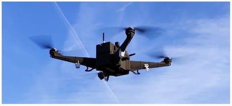
This study presents an operational approach to atmospheric wind profiling using a purpose-built meteorological uncrewed aerial vehicle (UAV) and an orientation-based wind estimation method that does not rely on dedicated onboard anemometers. The quadrotor platform, designed and developed by our team, has a maximum take-off mass of 2.45 kg and is capable of acquiring vertical atmospheric profiles up to 3000 m under a wide range of weather conditions. Within the framework of the World Meteorological Organization’s (WMO) global demonstration campaign for evaluating the use of uncrewed aircraft systems in operational meteorology and associated field activities, twelve vertical wind profiles were collected in parallel with radiosonde observations. UAV-based wind estimates were evaluated against radiosonde data using the WMO OSCAR (Observing Systems Capability Analysis and Review) performance framework. Across most wind speed regimes, the central 50% of UAV–radiosonde wind speed differences remain within OSCAR threshold requirements, indicating operationally relevant accuracy. Systematic deviations are physically interpretable and arise primarily in strongly sheared boundary-layer flows. A representative low-level jet case is used as a stress test, demonstrating that the UAV system remains safe and that wind estimates remain reliable even under extreme wind conditions, supporting robust performance in less demanding regimes. These results establish UAV-based wind profiling as a viable and complementary observing technique in the lower atmosphere and provide a practical pathway toward high-resolution, operational boundary-layer wind measurements.

7 February 2026

The purpose-built meteorological quadrotor UAV developed by the authors for boundary-layer profiling and deployed during the WMO’s demonstration campaign for wind measurements.

Recent developments in unmanned aerial vehicle (UAV) activity highlight the need for advanced electromagnetic spectrum monitoring systems that can detect drones operating near sensitive or restricted areas. Such systems can identify emissions from drones even under frequency-hopping conditions, providing an early warning system and enabling a timely response to protect critical infrastructure and ensure secure operations. In this context, the present work proposes the development of a high-performance multichannel broadband monitoring system with real-time analysis capabilities, designed on an SDR architecture based on USRP with three acquisition channels: two broadband (160 MHz and 80 MHz) and one narrowband (1 MHz) channel, for simultaneous, of extended spectrum segments, aligned with current requirements for analyzing emissions from drones in the 2.4 GHz and 5.8 GHz ISM bands. The processing system was configured to support cumulative bandwidths of over 200 MHz through a high-performance hardware platform (powerful CPU, fast storage, GPU acceleration) and fiber optic interconnection, ensuring stable and lossless transfer of large volumes of data. The proposed spectrum monitoring system proved to be extremely sensitive, flexible, and extensible, achieving a reception sensitivity of −130 dBm, thus exceeding the values commonly reported in the literature. Additionally, the parallel multichannel architecture facilitates real-time detection of signals from different frequency ranges and provides a foundation for advanced signal classification. Its reconfigurable design enables rapid adaptation to various signal types beyond unmanned aerial systems.

6 February 2026

Drone command and control center vs. individual drone remote control.

Multi-unmanned aerial vehicle (UAV) systems are crucial for establishing resilient communication networks in disaster-stricken areas, but their limited energy and dynamic characteristics pose significant challenges for sustained and reliable service provision. Optimizing resource allocation in this situation is a complex sequential decision-making problem, which is naturally suitable for multi-agent reinforcement learning (MARL). However, the most advanced MARL methods (e.g., multi-agent proximal policy optimization (MAPPO)) often encounter difficulties in the “loosely coupled” multi-UAV environment due to their overly centralized evaluation mechanism, resulting in unclear credit assignment and inhibiting personalized optimization. To overcome this, we propose a novel hierarchical framework supported by MAPPO with decoupled critics (MAPPO-DC). Our framework employs an efficient clustering algorithm for user association in the upper layer, while MAPPO-DC is used in the lower layer to enable each UAV to learn customized trajectories and power control strategies. MAPPO-DC achieves a complex balance between global coordination and personalized exploration by redesigning the update rules of the critic network, allowing for precise and personalized credit assignment in a loosely coupled environment. In addition, we designed a composite reward function to guide the learning process towards the goal of proportional fairness. The simulation results show that our proposed MAPPO-DC outperforms existing baselines, including independent proximal policy optimization (IPPO) and standard MAPPO, in terms of communication performance and sample efficiency, validating the effectiveness of our tailored MARL architecture for the task. Through model robustness experiments, we have verified that our proposed MAPPO-DC still has certain advantages in strongly coupled environments.

6 February 2026

Scenario diagram.

Thermal Drones Aid to Uncover Nocturnal Subgrouping Patterns of a Diurnal Primate

  • Eduardo José Pinel-Ramos,
  • Denise Spaan and
  • Filippo Aureli
  • + 1 author

Spider monkeys (Ateles spp.) have traditionally been described as strictly diurnal primates, with only low levels of activity during the night. Consequently, little attention has been given to the possibility of nocturnal movements and social dynamics occurring at sleeping sites. Recent advances in technologies, such as drone-based thermal infrared imaging (TIR), provide new opportunities to explore behavioral patterns that were previously undetectable through ground-based observations. In this study, we aimed to evaluate whether Geoffroy’s spider monkeys (Ateles geoffroyi) change their subgroup size once they are at their sleeping sites by comparing the numbers of monkeys detected after sunset with those detected before sunrise using TIR drone surveys. We conducted TIR drone flights over four sleeping sites of well-habituated Geoffroy’s spider monkey groups in Los Árboles Tulum in the Yucatán Peninsula, Mexico. We carried out 18 flight pairs—18 flights at sunset when the majority of individual spider monkeys were expected to have arrived at the sleeping sites, and 18 flights the next following morning at sunrise—before the monkeys began their daily movements. Our results revealed that in 12 out of the 18 flight pairs (67%), the number of monkeys counted at sunset differed from the number counted at sunrise. In 58% of these 12 flight pairs, more monkeys were counted at sunrise than at sunset. Furthermore, when changes in subgroup size occurred, they were more frequent (67%) when the subgroups at sleeping sites were larger (>10 monkeys). These changes in subgroup size are consistent with the occurrence of fissions and fusions continuing after dark. This study provides preliminary evidence that Geoffroy’s spider monkeys are more active during the night than generally assumed. Furthermore, our results highlight the value of TIR drones as an effective tool for studying primate social dynamics under low-light conditions. Unlike traditional ground-based observations, which depend on natural light, TIR drones allow for accurate and reliable monitoring throughout the night. By providing access to behavioral information that would otherwise remain hidden, this technology opens new possibilities for understanding the full temporal range of activity of diurnal species.

5 February 2026

Map of Los Arboles Tulum, Tulum, Mexico, with the grid of the 2 ha lots and the four Geoffroy’s spider monkey sleeping sites where TIR drone flights were carried out. Sites A, B, C, and D indicate the name of each sleeping site.

News & Conferences

Issues

Open for Submission

Editor's Choice

Reprints of Collections

Advances in Multi-Scale Geographic Environmental Monitoring
Reprint

Advances in Multi-Scale Geographic Environmental Monitoring

Theory, Methodology and Applications Volume II
Editors: Jingzhe Wang, Yangyi Wu, Yinghui Zhang, Ivan Lizaga, Zipeng Zhang

Get Alerted

Add your email address to receive forthcoming issues of this journal.

XFacebookLinkedIn
Drones - ISSN 2504-446X