Skip Content
You are currently on the new version of our website. Access the old version .

Conservation

Conservation is an international, peer-reviewed, open access journal on the biological, environmental, sociological, ethical, and economic and other transdisciplinary dimensions of conservation, published quarterly online by MDPI.
The World Association of Zoos and Aquariums (WAZA) is affiliated with Conservation and its members receive discounts on the article processing charges.
Quartile Ranking JCR - Q2 (Biodiversity Conservation)

All Articles (272)

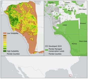
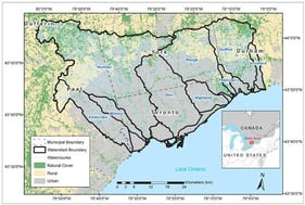
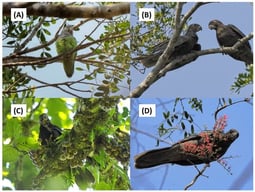
Rapid urban expansion across southwestern Florida has led to extensive habitat fragmentation and degradation, presenting significant ecological challenges for the persistence of multiple species, including the Big Cypress fox squirrel (Sciurus niger avicennia; BCFS), a state threatened and imperiled subspecies endemic to the Big Cypress Basin. This study uses high-resolution ecological modeling, Omniscape, to assess the functional connectivity of BCFS habitat within the urbanizing landscape of Fort Myers, Florida, and a green infrastructure (GI) transect-based approach to identify strategies for improving habitat and connectivity within the urban landscape. Results demonstrate that BCFS movement is disproportionately represented in high-density urban zones, with priority bottleneck patterns emerging in surrounding lower-density, transitional land use areas such as suburban neighborhoods and golf courses. By combining spatial modeling and applied GI design, this study offers a replicable framework for embedding species conservation into local and regional planning processes. Given the model-based and species-specific scope of this study, future research should focus on empirical validation and extending this framework across multiple species and scales. Overall, the findings emphasize the importance of multiscalar, landscape-sensitive planning strategies to mitigate anthropogenic fragmentation, enhance ecological resilience, and support the long-term persistence of native species in rapidly developing regions.

9 February 2026

Spatial overview of the BCFS habitat and development context in southwestern Florida. (Left) Habitat suitability model showing variation in landscape suitability for BCFS, ranging from low (brown) to high (dark green) suitability. (Right) Baseline development as of 2019 (gray) overlaid with Florida Managed Conservation Lands (green). County boundaries are outlined in gray for reference. The study area lies south of the Caloosahatchee River, as indicated in the regional inset map (bottom).

Systematic Conservation Planning for a Natural Heritage System in an Urbanizing Region

  • Andrew T. M. Chin,
  • Namrata Shrestha and
  • Marie-Josée Fortin
  • + 1 author

Urban areas worldwide face significant pressure from population growth and urban expansion, resulting in habitat loss. Urban planners need to develop a comprehensive strategy for protecting, restoring and enhancing natural heritage (such as natural features and assets), at the municipal and regional levels. Here, we propose an approach to design a Natural Heritage System (NHS) that interconnects natural features and areas. This resulting NHS aims to guide and prioritize the protection, restoration, and enhancement of ecological areas and their functions. The NHS integrates terrestrial and aquatic ecosystem functions for conservation planning. We leverage the Marxan optimization tool to identify target areas using 36 ecological features. We compare three spatial scenarios: regional-scale, watershed-scale, and a hybrid approach. We found that the hybrid scenario proved to be the most effective, covering 52% of the jurisdiction. Then, we classified the target areas into three tiers of the NHS: (1) existing natural cover (23.4%), (2) potential natural cover (12.3%), and (3) contributing areas (16.3%). Contributing areas represent additional parts of the NHS within developed or partly developed landscapes to support overall NHS health and ecological function. These tiers allow for tailored management actions: protection of existing natural cover and restoration of potential natural cover. Altogether, the areas identified for the NHS by Marxan provide a strong, science-based framework to address urbanization impacts and support long-term implementation of biodiversity and urban sustainability solutions. It also provides enhancement opportunities through green infrastructure in contributing areas using nature-based solutions aiming to conserve biodiversity in urban areas.

6 February 2026

Study area with the nine watersheds and land use within Toronto and Region Conservation Authority’s (TRCA) jurisdiction. The remaining area of the jurisdiction is the waterfront.

Madagascar is a global biodiversity hotspot, with approximately 90% of all its plant and animal species being endemic, most of them associated with forest ecosystems. This rich biodiversity is threatened by relentless deforestation; in 2014 only about 15% of the national territory retained highly fragmented native forests, and deforestation continues with worrying forecasts for the coming decades. This rapid loss of habitat is not only causing species losses, but also the loss of important ecological functions that may disappear well before the extinction of the species involved. Here we want to draw attention to the three species of parrots endemic to Madagascar, for which there is a lack of systematically collected data on their distribution and population trends. We compiled available evidence, including data derived from citizen science, suggesting that the distribution and abundance of at least two of the three parrot species have declined in recent decades. These declines are likely driven not only by forest loss but also by persecution for the pet trade, crop protection, and hunting for food. There is also evidence, although still scarce, showing that these parrot species not only act as plant antagonists, but also fulfill mutualistic functions such as seed dispersal by different mechanisms, pollination, and maintenance of plant health. We urge researchers to study the current distribution and population size of the Malagasy parrots, as well as the full antagonism–mutualism spectrum of relationships with their food plants. This is needed for assessing their current conservation status, which may be significantly worse than that reflected by the IUCN Red List, and for identifying important ecological functions that may be lost before the disappearance of the species involved, which can be key to the maintenance and regeneration of the forests they inhabit.

5 February 2026

The three parrots endemic to Madagascar: gray-headed lovebird Agapornis canus (A), vasa parrot Coracopsis vasa (B), and black parrot Coracopsis nigra (C,D). Photographs: José L. Tella.

Steep Population Declines in Insectivorous Passerines, Irrespective of Their Migratory Strategies

  • Ana Patrícia Almeida,
  • Miguel Araújo and
  • Jaime A. Ramos
  • + 1 author

This study examines a long-term dataset where 16 passerine species, classified as long-distance migrants, short-distance migrants, and residents were monitored at the Santo André National Ringing Station (Portugal) from 1997 to 2024. Using standardized capture data from 16 passerines species collected during the autumn migration period, we evaluated trends in population abundance over a 27-year time span. Our analyses revealed pronounced and statistically robust declines in all long-distance migratory species, particularly savi’s warbler, grasshopper warbler, and sedge warbler, which are now almost locally extinct. In contrast, short-distance migrants and resident species exhibited more heterogeneous patterns depending on their ecological specialization, yet all strictly insectivorous taxa, except for the chiffchaff, showed marked population declines, particularly the bluethroat and the sardinian warbler. The parallel decline in insectivorous species across migratory strategies points to a widespread trophic effect, likely linked to the global depletion of insect populations, driven by habitat destruction, pesticide use, pollution, and climate change. Collectively, these findings emphasize the urgent need for regionally adapted, long-term monitoring programs to inform effective conservation strategies in the face of accelerating climate and land-use change.

5 February 2026

Study area map, Reserva Natural das Lagoas de Santo André e Sancha (38°6′ N, 8°48′ W), located on the southwestern coast of Portugal (ICNF—Instituto da Conservação da Natureza e das Florestas). The blue stars represent the ringing points, where mist nets were used.

News & Conferences

Issues

Open for Submission

Editor's Choice

Get Alerted

Add your email address to receive forthcoming issues of this journal.

XFacebookLinkedIn
Conservation - ISSN 2673-7159