
Changes in the Water Area of an Inland River Terminal Lake (Taitma Lake) Driven by Climate Change and Human Activities, 2017–2022

Abstract
:1. Introduction
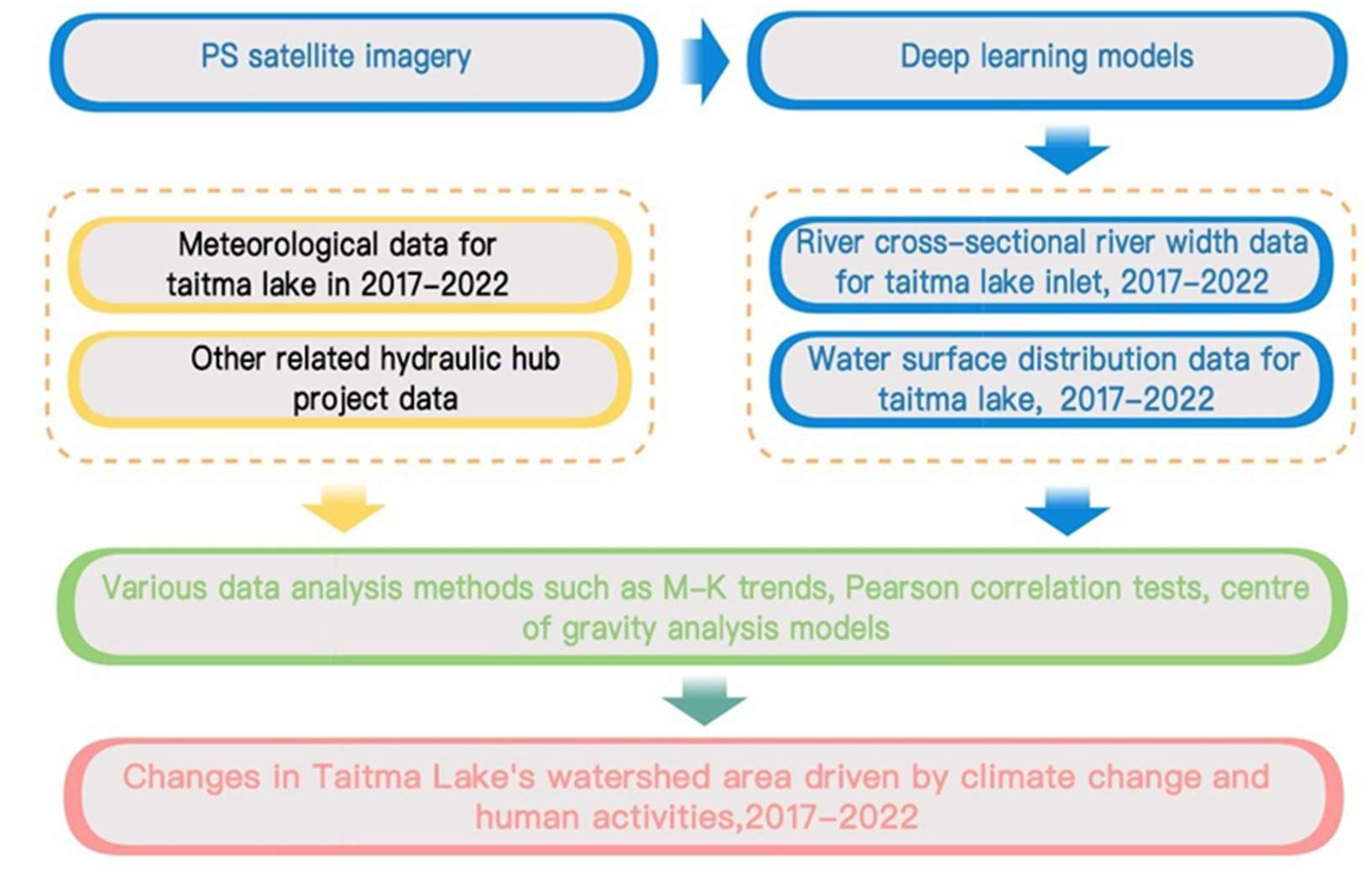
2. Materials and Methods
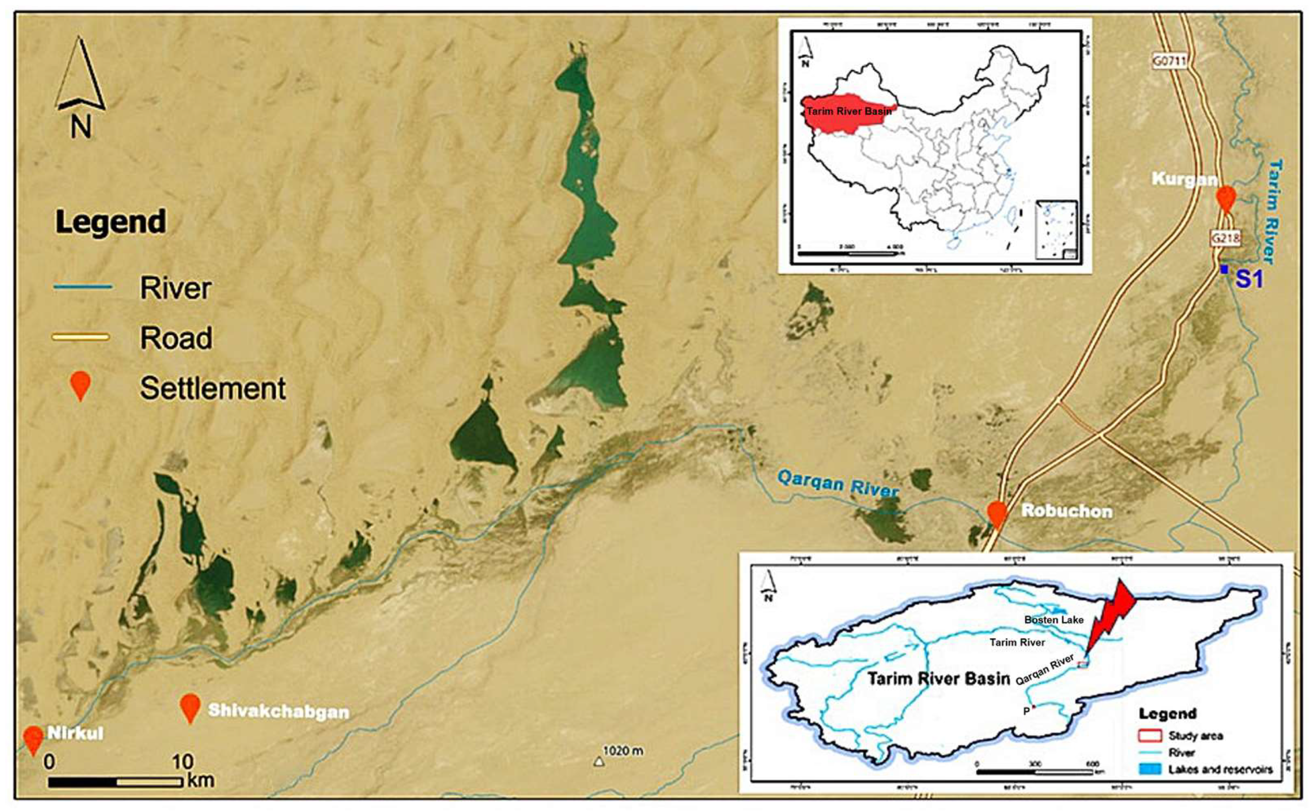
2.1. Study Area
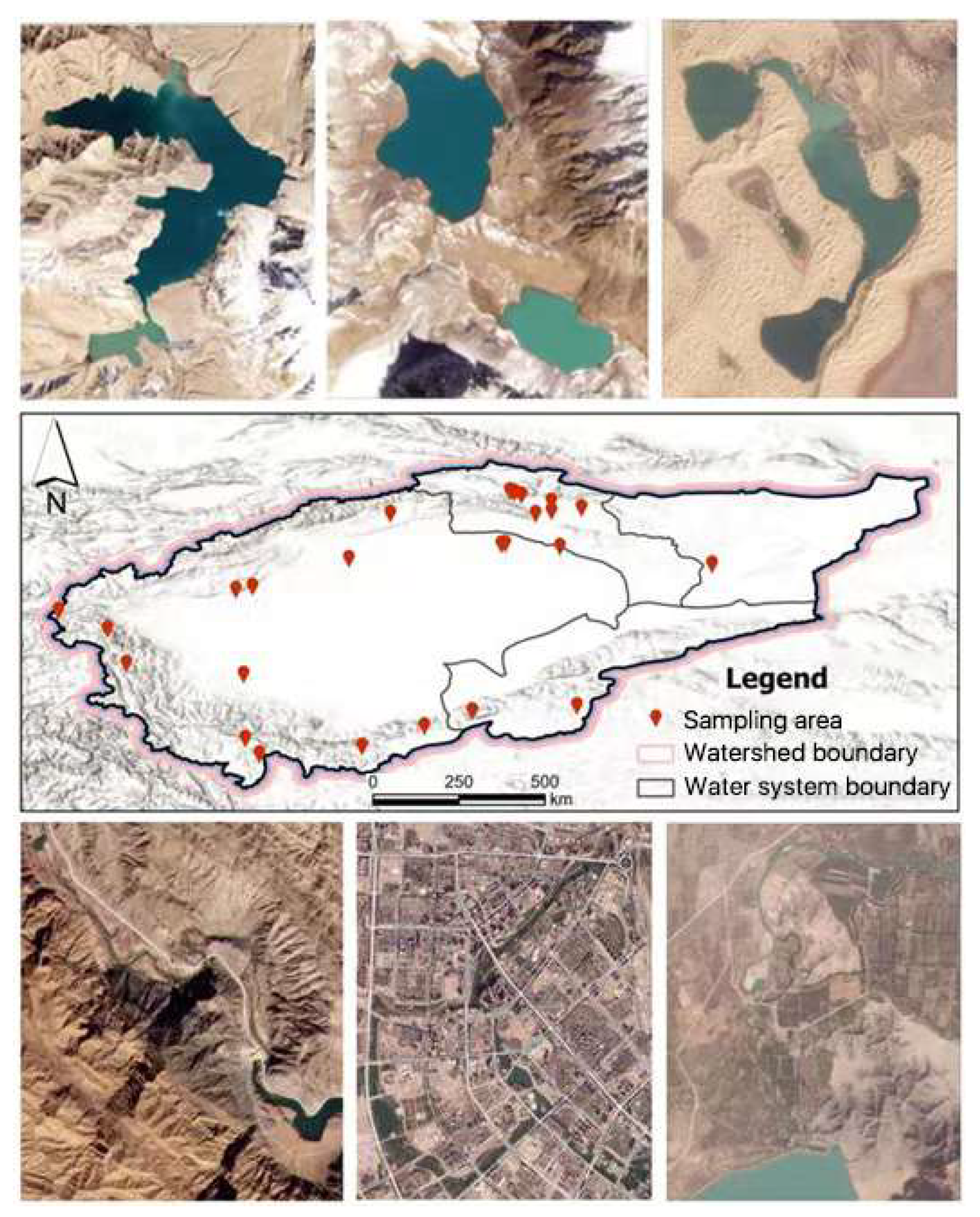
2.2. Data Sources
2.3. Methodology
2.3.1. Water Extraction and Evaluation Methods
- (1)
- Image data acquisition
- (2)
- Water extraction process
- (3)
- Accuracy evaluation index
2.3.2. Data Analysis Methods
- (1)
- Mann–Kendall trend test
- (2)
- Pearson correlation test
- (3)
- Center of gravity analysis model
- (4)
- Annual maximum water surface synthesis
3. Results
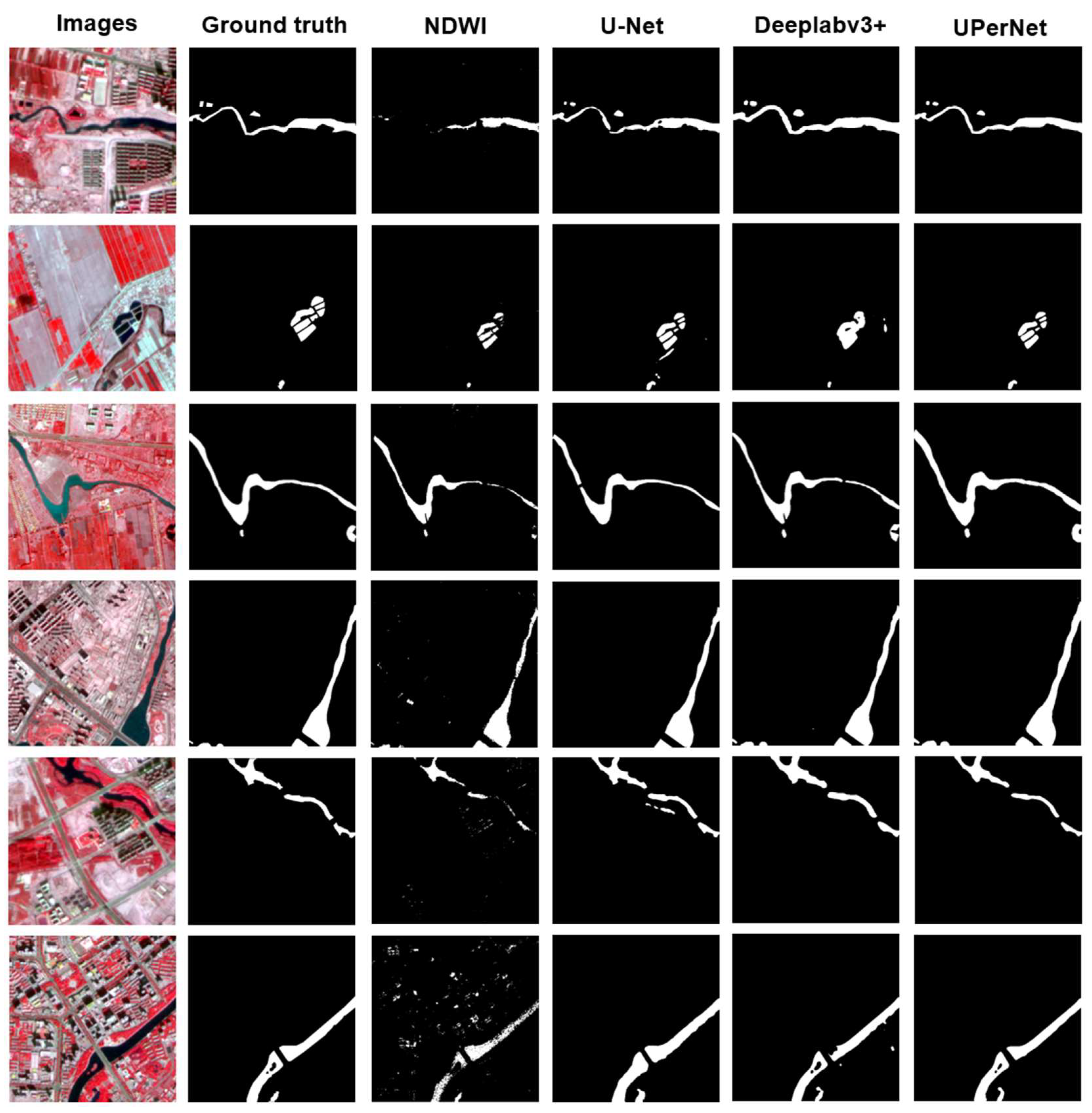
3.1. Evaluation of the Accuracy of Water Extraction Results
3.1.1. Accuracy Evaluation Results of the Overall Water Body
3.1.2. Accuracy Evaluation Results of Fine Water Bodies
3.2. Temporal and Spatial Changes in the Water Area of Taitma Lake
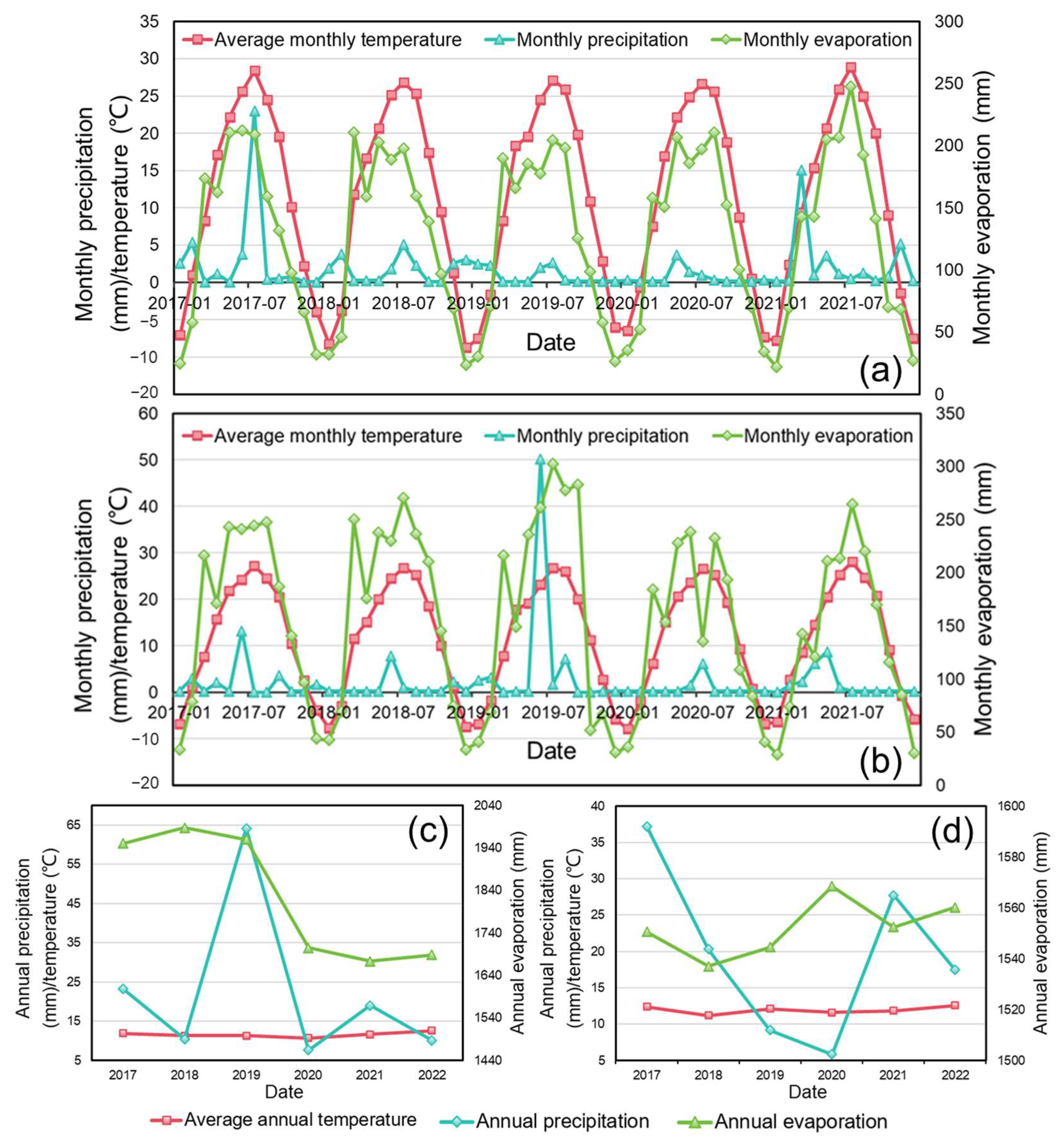
3.3. Climatic Influences on Water Surface Dynamics in Taitma Lake
4. Discussion
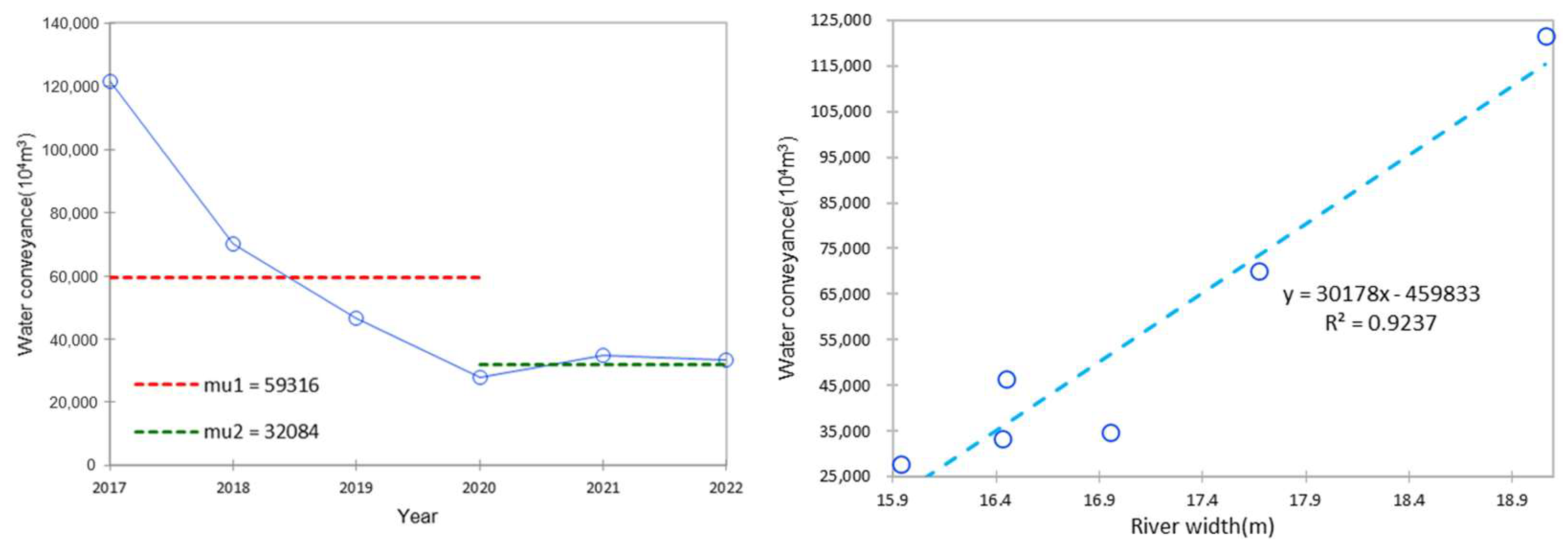
4.1. Analysis of the Causes of Changes in Water Area of Taitma Lake
4.2. Implications of Water Area Variability in Taitma Lake
5. Conclusions
- (1)
- In the water body extraction experiments, the deep learning model outperforms the conventional water body index method by a significant margin. UPerNet is the most successful network model in this study, with overall and fine water body-specific accuracies of 96.0 and 90.0%, respectively, and respective F1 values of 96.6 and 90.2%.
- (2)
- The water area of Taitma Lake has clearly displayed seasonal variations between 2017 and 2022, reaching its peak value in March. Its water area has been significantly declining over the past six years at a rate of 31.12 km2 per year on average, leading to the noticeable two-phase alterations (2017–2020 and 2020–2022) and a shift in the center of gravity of the water distribution to the northwest.
- (3)
- The influence of human activity played a major role in the Taitma Lake watershed area’s reduction during the past six years. Among them, the decrease in ecological water transfer from the upper Tarim River in 2017–2020 was the main reason for the decrease in Taitma Lake’s watershed area, while the completion of the Dashimen Hydraulic Hub Project impoundment on the upper Qarqan River was the main reason for the exponential and sudden decrease in its area in 2020–2022.
Author Contributions
Funding
Data Availability Statement
Acknowledgments
Conflicts of Interest
References
- Yamazaki, D.; Trigg, M.A.; Ikeshima, D. Development of a global~ 90 m water body map using multi-temporal Landsat images. Remote Sens. Environ. 2015, 171, 337–351. [Google Scholar] [CrossRef]
- Pekel, J.F.; Cottam, A.; Gorelick, N.; Belward, A.S. High-resolution mapping of global surface water and its long-term changes. Nature 2016, 540, 418–422. [Google Scholar] [CrossRef]
- Chang, B.; Li, R.; Zhu, C.; Liu, K. Quantitative impacts of climate change and human activities on water-surface area variations from the 1990s to 2013 in Honghu Lake, China. Water 2015, 7, 2881–2899. [Google Scholar] [CrossRef]
- Ma, R.; Yang, G.; Duan, H.T.; Jiang, J.H.; Wang, S.M.; Feng, X.Z.; Li, A.N.; Kong, F.X.; Xue, B.; Wu, J.L.; et al. Number, area and spatial distribution of lakes in China. Sci. China Earth Sci. 2011, 41, 394–401. (In Chinese) [Google Scholar]
- Zhang, P.; Japal, G.; Bao, A.; Meng, F.; Guo, H.; Guo, H.; Luo, M.; Huang, X. Evaluation of the ecological effectiveness of recent comprehensive management projects in the Tarim River Basin. Arid. Area Geogr. 2017, 40, 156–164. (In Chinese) [Google Scholar]
- Klein, I.; Dietz, A.; Gessner, U.; Galayeva, A.; Myrzakhmetov, A.; Kuenzer, C. Evaluation of seasonal water body extents in Central Asia over the past 27 years derived from medium-resolution remote sensing data. Int. J. Appl. Earth Obs. Geoinf. 2014, 26, 335–349. [Google Scholar] [CrossRef]
- Chen, J.; Chen, S.; Fu, R.; Li, D.; Jiang, H.; Wang, C.; Peng, Y.; Jia, K.; Hicks, B. Remote sensing big data for water environment monitoring: Current status, challenges, and future prospects. Earth’s Future 2022, 10, e2021EF002289. [Google Scholar] [CrossRef]
- Wu, W.; Li, Q.; Zhang, Y.; Du, X.; Wang, H. Two-step urban water index (TSUWI): A new technique for high-resolution mapping of urban surface water. Remote Sens. 2018, 10, 1704. [Google Scholar] [CrossRef]
- Li, Y.; Dang, B.; Zhang, Y.; Du, Z. Water body classification from high-resolution optical remote sensing imagery: Achievements and perspectives. ISPRS J. Photogramm. Remote Sens. 2022, 187, 306–327. [Google Scholar] [CrossRef]
- Ronneberger, O.; Fischer, P.; Brox, T. U-net: Convolutional networks for biomedical image segmentation. In Proceedings of the Medical Image Computing and Computer-Assisted Intervention–MICCAI 2015: 18th International Conference, Munich, Germany, 5–9 October 2015; Part III 18. Springer International Publishing: Cham, Switzerland, 2015; pp. 234–241. [Google Scholar]
- Su, H.; Peng, Y.; Xu, C.; Feng, A.; Liu, T. Using improved DeepLabv3+ network integrated with normalized difference water index to extract water bodies in Sentinel-2A urban remote sensing images. J. Appl. Remote Sens. 2021, 15, 018504. [Google Scholar] [CrossRef]
- Xiao, T.; Liu, Y.; Zhou, B.; Jiang, Y.; Sun, J. Unified perceptual parsing for scene understanding. In Proceedings of the European Conference on Computer Vision (ECCV), Munich, Germany, 8–14 September 2018; pp. 418–434. [Google Scholar]
- Zhao, X.; Xu, H.; Zhang, P. Changes of lake area, groundwater level and vegetation under the influence of ecological water conveyance—A case study of the tail lake of Tarim River in China. Water 2022, 14, 1026. [Google Scholar] [CrossRef]
- Huang, W.; Duan, W.; Chen, Y. Unravelling lake water storage change in Central Asia: Rapid decrease in tail-end lakes and increasing risks to water supply. J. Hydrol. 2022, 614, 128546. [Google Scholar] [CrossRef]
- Chen, Y.; Zhang, X.; Zhu, X.; Li, W.; Zhang, Y.; Xu, H.; Zhang, H.; Chen, Y. Analysis on the ecological benefits of the stream water conveyance to the dried-up river of the lower reaches of Tarim River, China. Sci. China Ser. D Earth Sci. 2014, 47, 1053–1064. [Google Scholar] [CrossRef]
- Chen, Y.; Xu, Z. Plausible impact of global climate change on water resources in the Tarim River Basin. Sci. China Ser. D Earth Sci. 2005, 48, 65–73. [Google Scholar] [CrossRef]
- Zhang, Z.; Hu, H.; Tian, F.; Yao, X.; Sivapalan, M. Groundwater dynamics under water-saving irrigation and implications for sustainable water management in an oasis: Tarim River basin of western China. Hydrol. Earth Syst. Sci. 2014, 18, 3951–3967. [Google Scholar] [CrossRef]
- Deng, M.; Zhou, H.; Xu, H.; Ling, H.; Zhang, P. Research on ecological water conveyance and ecological regulation in the lower reaches of the Tarim River. Sci. China Tech. Sci. 2016, 46, 864–876. (In Chinese) [Google Scholar]
- Wang, Y.; Zhang, Q.; Xu, H.; Zhao, X.; Liu, X.; Li, J. Change characteristics of plant diversity in Taitma Lake before and after ecological water transfer. Arid. Zone Res. 2019, 36, 1186–1193. (In Chinese) [Google Scholar]
- Huo, T.; Yan, W.; Ma, X. Research on water area change and driving factors of inland river tail lakes. Remote Sens. Land Resour. 2020, 32, 149–156. (In Chinese) [Google Scholar]
- Wang, S. Research on the Evolution and Influencing Factors of Ecological Environment in Taitma Lake Area in the Past 30 Years. Master’s Thesis, Hebei Normal University, Shijiazhuang, China, 2019. (In Chinese). [Google Scholar]
- Zhao, R.; Chen, Y.; Shi, P.; Zhang, L.; Pan, J.; Zhao, H. Land use and land cover change and driving mechanism in the arid inland river basin: A case study of Tarim River, Xinjiang, China. Environ. Earth Sci. 2013, 68, 591–604. [Google Scholar] [CrossRef]
- Ling, H.; Zhang, P.; Xu, H.; Zhang, G. Determining the ecological water allocation in a hyper-arid catchment with increasing competition for water resources. Glob. Planet. Chang. 2016, 145, 143–152. [Google Scholar] [CrossRef]
- Naumburg, E.; Mata-Gonzalez, R.; Hunter, R.G.; Mclendon, T.; Martin, D.W. Phreatophytic vegetation and groundwater fluctuations: A review of current research and application of ecosystem response modeling with an emphasis on Great Basin vegetation. Environ. Manag. 2005, 35, 726–740. [Google Scholar] [CrossRef] [PubMed]
- Chen, Y.; Li, W.; Chen, Y.; Xu, C.; Zhang, L. Water transportation and ecological restoration of broken river channels in the lower reaches of the Tarim River, Xinjiang. Acta Ecol. Sin. 2007, 27, 538–545. (In Chinese) [Google Scholar]
- Wang, X.; Xiao, X.; Zou, Z.; Dong, J.; Qin, Y.; Doughty, R.B.; Menarguez, M.B.; Chen, B.; Wang, J.; Ye, H.; et al. Gainers and losers of surface and terrestrial water resources in China during 1989–2016. Nat. Commun. 2020, 11, 3471. [Google Scholar] [CrossRef] [PubMed]
- Roy, D.P.; Huang, H.; Houborg, R.; Martins, V.S. A global analysis of the temporal availability of PlanetScope high spatial resolution multi-spectral imagery. Remote Sens. Environ. 2021, 264, 112586. [Google Scholar] [CrossRef]
- Ren, Y.; Zhang, X.; Ma, Y.; Yang, Q.; Wang, C.; Liu, H.; Qi, Q. Full convolutional neural network based on multi-scale feature fusion for the class imbalance remote sensing image classification. Remote Sens. 2020, 12, 3547. [Google Scholar] [CrossRef]
- Nesteruk, S.; Illarionova, S.; Akhtyamov, T.; Shadrin, D.; Somov, A.; Pukalchik, M.; Oseledets, I. Xtremeaugment: Getting more from your data through combination of image collection and image augmentation. IEEE Access 2022, 10, 24010–24028. [Google Scholar] [CrossRef]
- Mann, H.B. Nonparametric tests against trend. Econom. J. Econom. Soc. 1945, 13, 245–259. [Google Scholar] [CrossRef]
- Wang, J. Determining the most accurate program for the Mann-Kendall method in detecting climate mutation. Theor. Appl. Climatol. 2020, 142, 847–854. [Google Scholar] [CrossRef]
- Chen, S.; Gao, W.; Chen, X.; Tu, Y.; Yang, Y. A fast fault diagnosis method for photovoltaic array based on extreme learning machine and Pearson correlation coefficient. Electr. Technol. 2021, 22, 57–64. (In Chinese) [Google Scholar]
- Zhong, H.F.; Sun, Q.; Sun, H.M.; Jia, R.S. NT-Net: A Semantic Segmentation Network for Extracting Lake Water Bodies From Optical Remote Sensing Images Based on Transformer. IEEE Trans. Geosci. Remote Sens. 2022, 60, 1–13. [Google Scholar] [CrossRef]
- Peng, H.; Xue, C.; Shao, Y.; Chen, K.; Xiong, J.; Xie, Z.; Zhang, L. Semantic segmentation of litchi branches using DeepLabV3+ model. IEEE Access 2020, 8, 164546–164555. [Google Scholar] [CrossRef]
- Guo, H.; He, G.; Jiang, W.; Yin, R.; Yan, L.; Leng, W. A multi-scale water extraction convolutional neural network (MWEN) method for GaoFen-1 remote sensing images. ISPRS Int. J. Geo-Inf. 2020, 9, 189. [Google Scholar] [CrossRef]
- Gou, J.; Jiang, Y.; Li, Z.; Dong, X.; Wu, B.; Liu, Z. Extraction of aquaculture water body information in Chengdu Plain based on Deeplabv3+ model. J. Chin. Agric. Mech. Eng. 2021, 42, 105. (In Chinese) [Google Scholar]
- Huang, J.; Zhang, Y.; Wang, M.; Wang, F.; Tang, Z.; He, H. Spatial and temporal distribution characteristics of drought and its relationship with meteorological factors in Xinjiang in last 17 years. Acta Ecol. Sin 2020, 40, 1077–1088. [Google Scholar]
- Liu, B.; Zhao, Y.; Wang, W.; Liu, B. Compaction density evaluation model of sand-gravel dam based on Elman neural network with modified particle swarm optimization. Front. Phys. 2022, 9, 818. [Google Scholar] [CrossRef]
- Liu, Y.; Zhang, F.; Wu, H.; Li, Y.; Jiang, Z.; Li, Q.; Wang, Y.; Yi, T. Research on flood forecast of dashimen reservoir in xinjiang based on melting snow and runoff yield under excess infiltration. In Proceedings of the 2021 International Conference on Water Conservancy, Energy and Environmental Engineering, Nanjing, China, 25–27 June 2021; Volume 826, p. 012010. [Google Scholar]
- Fan, Z.; Xu, H.; Fu, Y. Research on wetland protection of Taitma Lake. Quat. Res. 2013, 33, 594–602. (In Chinese) [Google Scholar]
- Zhou, X.; Yi, S.; Zhao, W.; Zhou, Q.; Shen, J.; Li, D.; Huo, B.; Tang, R. Genetic diversity and population differentiation of kashgarian loach (Triplophysa yarkandensis) in Xinjiang Tarim River basin. Biology 2021, 10, 734. [Google Scholar] [CrossRef]
- Wang, H.; Hasim, T. Analysis of ecological environment changes in Taitma Lake before and after ecological water transfer. Ecol. Sci. 2020, 39, 93. (In Chinese) [Google Scholar]


| Method | P (%) | R (%) | F1 (%) | PA (%) | mIoU (%) |
|---|---|---|---|---|---|
| NDWI | 85.4 | 94.7 | 89.8 | 93.2 | 81.4 |
| U-Net | 90.4 | 97.8 | 94.0 | 96.1 | 88.6 |
| Deeplabv3+ | 94.2 | 97.3 | 95.7 | 97.3 | 91.8 |
| uPerNet | 96.0 | 97.1 | 96.6 | 97.9 | 93.4 |
| Method | P (%) | R (%) | F1 (%) | PA (%) | mIoU (%) |
|---|---|---|---|---|---|
| NDWI | 86.5 | 54.9 | 70.0 | 89.6 | 53.8 |
| U-Net | 84.3 | 76.1 | 80.0 | 98.5 | 66.7 |
| Deeplabv3+ | 75.4 | 97.4 | 85.0 | 98.6 | 73.9 |
| UPerNet | 90.0 | 90.5 | 90.2 | 99.2 | 82.2 |
| M–K Test | Kendall’s Tau | Alpha | p-Value | Hypothesis H0 |
|---|---|---|---|---|
| — — | −0.733 | 0.1 | 0.060 | Reject |
| Year | Lon (°) | Lat (°) | Moving direction | Moving Distance (km) |
| 2017 | 88.164 | 39.511 | — — | — — |
| 2018 | 88.163 | 39.509 | southwest | 0.316 |
| 2019 | 88.154 | 39.509 | southwest | 0.961 |
| 2020 | 88.150 | 39.510 | northwest | 0.439 |
| 2021 | 88.116 | 39.513 | northwest | 3.811 |
| 2022 | 88.099 | 39.518 | northwest | 1.981 |
| Lake Taitma | Parameters | Average Annual Temperature (°C) | Annual Precipitation (mm) | Annual Evaporation (mm) |
|---|---|---|---|---|
| Area (km2) | Pearson correlation | −0.232 | −0.052 | −0.439 |
| Significance | 0.658 | 0.922 | 0.384 | |
| Number of samples | 6 | 6 | 6 |
Disclaimer/Publisher’s Note: The statements, opinions and data contained in all publications are solely those of the individual author(s) and contributor(s) and not of MDPI and/or the editor(s). MDPI and/or the editor(s) disclaim responsibility for any injury to people or property resulting from any ideas, methods, instructions or products referred to in the content. |
© 2024 by the authors. Licensee MDPI, Basel, Switzerland. This article is an open access article distributed under the terms and conditions of the Creative Commons Attribution (CC BY) license (https://creativecommons.org/licenses/by/4.0/).
Share and Cite
Zi, F.; Wang, Y.; Lu, S.; Ikhumhen, H.O.; Fang, C.; Li, X.; Wang, N.; Kuang, X. Changes in the Water Area of an Inland River Terminal Lake (Taitma Lake) Driven by Climate Change and Human Activities, 2017–2022. Remote Sens. 2024, 16, 1703. https://doi.org/10.3390/rs16101703
Zi F, Wang Y, Lu S, Ikhumhen HO, Fang C, Li X, Wang N, Kuang X. Changes in the Water Area of an Inland River Terminal Lake (Taitma Lake) Driven by Climate Change and Human Activities, 2017–2022. Remote Sensing. 2024; 16(10):1703. https://doi.org/10.3390/rs16101703
Chicago/Turabian StyleZi, Feng, Yong Wang, Shanlong Lu, Harrison Odion Ikhumhen, Chun Fang, Xinru Li, Nan Wang, and Xinya Kuang. 2024. "Changes in the Water Area of an Inland River Terminal Lake (Taitma Lake) Driven by Climate Change and Human Activities, 2017–2022" Remote Sensing 16, no. 10: 1703. https://doi.org/10.3390/rs16101703