
Skip to Content
You are currently on the new version of our website. Access the old version .
  • 3.2
    Impact Factor
  • 6.7
    CiteScore
  • 35 days
    Submission to First Decision
  • 3 days
    Acceptance to Publication

ISPRS International Journal of Geo-Information

ISPRS International Journal of Geo-Information (IJGI) is an international, peer-reviewed, open access journal on geo-information, published monthly online. It is the official journal of the International Society for Photogrammetry and Remote Sensing (ISPRS). Society members receive discounts on the article processing charges.
  • Open Access— free for readers, with article processing charges (APC) paid by authors or their institutions.
  • High Visibility: indexed within Scopus, SCIE (Web of Science), GeoRef, PubAg, dblp, Astrophysics Data System, Inspec, and other databases.
  • Journal Rank: JCR - Q2 (Geography, Physical) / CiteScore - Q1 (Earth and Planetary Sciences (miscellaneous))
  • Rapid Publication: manuscripts are peer-reviewed and a first decision is provided to authors approximately 34.9 days after submission; acceptance to publication is undertaken in 2.9 days (median values for papers published in this journal in the first half of 2026).
  • Rejection Rate: a rejection rate of 74% in 2025.
  • Recognition of Reviewers: Reviewers whose reports are timely and of high quality receive an APC discount voucher for a future publication in an MDPI journal. Become a reviewer.

Get Alerted

Add your email address to receive forthcoming issues of this journal.

All Articles (6,243)

  • Article
  • Open Access

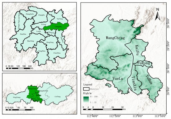
This study proposes the innovative “GIS–Generalized Symmetric Structural Graph” Framework for Restaurant Differentiation (GGSF), integrating GIS spatial analysis with generalized symmetric structural graphs. Taking Changsha’s urban core as a case study, we analyze the spatial distribution and agglomeration patterns of catering establishments to reveal their underlying formation mechanisms. Results indicate a “one core with multiple sub-centers” and “dense in the east, sparse in the west” pattern. Specifically, Chinese catering concentrates in old urban areas, international dining concentrates in CBDs, snacks and fast food span the entire region, and desserts and drinks align with youth consumption spaces. Furthermore, 99% of outlets have a nearest-neighbor distance ≤500 m, demonstrating a negative correlation between outlet density and average neighbor distance. The GGSF uncovers a hidden static spatial order that is closely associated with natural geography, policy, and transportation. This study verifies the framework’s applicability, offering a replicable model for understanding urban commercial spatial laws, optimizing layouts, and promoting the sustainable development of urban functional spaces.

ISPRS Int. J. Geo-Inf.

15 November 2026

Location map of the study area.
  • Article
  • Open Access

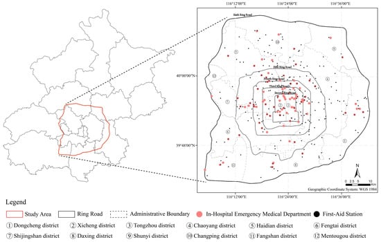
Improving the survival rates of critically ill and injured patients, particularly vulnerable groups such as children and older people, necessitates timely and effective emergency medical services (EMS). However, current research on EMS accessibility typically overlooks the additional travel time required to take patients to hospitals. This study proposes a two-stage nearest-facility supply–demand accessibility index for evaluating potential emergency medical services accessibility (PEMSA) (PEMSA represents only the morning-peak scenario), accounting for both supply–demand disparities and the time sensitivity of emergency response, with the area within Beijing’s Sixth Ring Road serving as a case study. The two-stage EMS framework involves transportation from the closest first-aid station to the residential community, and transportation from the residential community to the nearest emergency department. The Gini coefficient is employed to examine the equity of PEMSA across the research area’s administrative districts. A multiscale geographically weighted regression (MGWR) model is employed to evaluate the relationship between PEMSA and demographic characteristics, namely the percentages of children and older people. The results indicate that PEMSA follows a core–periphery spatial pattern. Based on accessibility and equitable outcomes, the identified spatial mismatch areas are classified as critical priority, priority, or sub-priority intervention zones. The primary reasons for this accessibility discrepancy are road traffic congestion and a geographic mismatch between emergency facility density and demographic distribution; accessibility is significantly correlated with the proportions of children and older people. These findings, as well as the proposed analytical framework, are valuable for evaluating urban EMS accessibility and optimizing the spatial layout of EMS.

ISPRS Int. J. Geo-Inf.

11 November 2026

Study area.
  • Article
  • Open Access

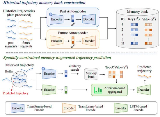
Accurate vessel trajectory prediction in complex nearshore waters remains challenging because local traffic patterns are highly heterogeneous and similar observed trajectories may lead to different future route continuations. Although historical Automatic Identification System (AIS) archives contain valuable evidence of previous vessel movements, such information is typically absorbed into model parameters rather than explicitly accessed during prediction. To address this limitation, this study proposes a spatially constrained memory-augmented framework for vessel trajectory prediction. An extensible key–value memory bank is constructed from paired representations of historical past and future trajectory segments. During prediction, geographically relevant candidates are first identified through spatial filtering, and the most similar historical trajectories are retrieved in the learned representation space. The corresponding future representations are then selectively aggregated with the current observed trajectory representation through an attention mechanism conditioned to generate the future trajectory. Experiments on AIS trajectories from the Pearl River Delta and adjacent coastal waters show that the proposed model consistently outperforms baselines over 60, 120, and 180 min horizons, with particularly clear improvements over the long short-term memory (LSTM) prediction backbone without historical trajectory fusion. Ablation results further confirm the effectiveness of spatially constrained retrieval and attention-based memory fusion, particularly for longer-horizon prediction.

ISPRS Int. J. Geo-Inf.

11 November 2026

Workflow of memory-augmented trajectory prediction after data processing.
  • Article
  • Open Access

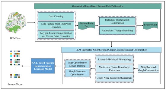
Geospatial data contains abundant temporal, spatial, and attribute information related to geographic entities, serving as a critical foundation for the development of new quality productive forces. Achieving effective semantic representation of geographic features is a key prerequisite for enabling intelligent data analysis and application. Spatial relationships are an essential semantic characteristic of geographic features and are among the most commonly introduced characteristics for representation learning in recent studies. However, current research primarily focuses on point-based features (such as POIs) or on converting line and polygon features into point features, leading to inaccuracies in representing spatial proximity between features, which in turn affects the representation outcomes. In this paper, a feature unit delineation method based on geometric shapes is proposed to better construct the proximity relationship graph between features. It enriches the semantic features of feature units using a large language model and trains an edge optimization model to refine the graph structure. Building upon iGCL, a semantic representation learning model for geographic features is constructed. Finally, using Xiamen Island and Nanchang City as study areas, experimental datasets are built by integrating OSM and Amap (Gaode) POI data. The performance of the proposed model is validated and compared with other models through three tasks: semantic overlap calculation, node classification, and node clustering. The results show that the feature representations obtained by the proposed model achieve the best performance across all tasks, fully demonstrating its effectiveness and superiority in geographic feature representation learning, thereby providing a foundation for subsequent intelligent geographic feature tasks.

ISPRS Int. J. Geo-Inf.

11 November 2026

Framework of the method.

Featured Articles of Last Quarter

Highly Accessed Articles

News & Conferences

Latest Issues

Open for Submission

Journal Sections

XFacebookLinkedIn
ISPRS Int. J. Geo-Inf. - ISSN 2220-9964