

Data, Volume 7, Issue 8 (August 2022) – 17 articles
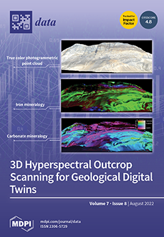
Cover Story (view full-size image):
Hyperspectral imaging is an innovative and versatile technology for non-invasive mapping. Robust processing workflows are required to ensure its wide usage. We present an open-source hypercloud dataset that captures the geology of the Black Angel Mountain (Greenland), alongside a detailed and interactive tutorial. This contribution relies on progress made on the correction, interpretation and integration of hyperspectral data. The fusion of hyperspectral scans with 3D point cloud representations opens up new possibilities for the mapping of complex natural targets. Spectroscopic and machine learning tools allow for the rapid and accurate characterization of geological structures in 3D. Users train themselves or test new algorithms with this dataset and the associated tools. View this paper
- Issues are regarded as officially published after their release is announced to the table of contents alert mailing list.
- You may sign up for e-mail alerts to receive table of contents of newly released issues.
- PDF is the official format for papers published in both, html and pdf forms. To view the papers in pdf format, click on the "PDF Full-text" link, and use the free Adobe Reader to open them.
Previous Issue
Next Issue