Article

Identification of Geodiversity and Geosite Assessment around Geohazard Area of Suoh Aspiring Geopark in West Lampung, Sumatra, Indonesia

1
Faculty of Geological Engineering, Padjadjaran University, Sumedang 45363, Indonesia
2
Indonesian Geotourism Society, Jakarta 12230, Indonesia
3
Research Center for Geological Resources, National Research and Innovation Agency, Bandung 40115, Indonesia
4
Laboratory of Engineering Geology, Faculty of Geological Engineering, Padjadjaran University, Sumedang 45363, Indonesia
*
Authors to whom correspondence should be addressed.
Resources 2022, 11(11), 104; https://doi.org/10.3390/resources11110104
Submission received: 17 September 2022 / Revised: 10 November 2022 / Accepted: 11 November 2022 / Published: 16 November 2022
(This article belongs to the Special Issue Geodiversity Assessment: What, Why and How?)

Abstract

:
Indonesia has been actively promoting the Sustainable Development Goals (SDGs) agreed upon at the United Nations General Assembly in 2015. Pursuing economic expansion through extraction of natural resources is an obsolete paradigm that is becoming increasingly outdated. Therefore, the geopark concept has broken the idea of economic progress that damages the environment. Geoparks seek to safeguard geodiversity, educate the public about geological history, and assist the long-term economic growth of geopark areas, particularly through geotourism. Geotourism is a sort of creative tourism that is fast growing across the world. This paper aims to assess the existing status and geotourism potential in order to identify the best geosites for the West Lampung region’s initial geopark development. The methods of this study are a geology and geopark literature review, fieldwork, data analysis, and synthesis. The procedure includes inventorying and identifying geodiversity. The study looked at rock and outcrops to piece together the geological history of the West Lampung region. This study showed that the West Lampung region offers several remarkable geosites with significant geotourism development potential. Asam Lake, Nirwana Crater, and Point View Suoh Valley in the Suoh part have the greatest final values, followed by Batubrak Fault Depression in the Fault Depression section. The Batubrak Fault Depression and Asam Lake have significant scientific and tourist value, particularly in terms of portrayal, uniqueness, perspectives, scenery, and natural surroundings. In the Suoh section, Nirwana Crater, Kopi Susu Crater, Keramikan Crater, and Point View Suoh Valley have significant scientific importance but poor educational and tourism value, while the other sites have low scientific, tourist, and educational value, thus placing the area at the bottom of the assessment even though overall it is of medium value. It can be concluded that several geosites in West Lampung have poor value due to some factors such as location accessibility, tourism infrastructure, and location management. Looking at the total findings, basic tourism infrastructure, visitor center, and tour guide services, as well as promotional efforts, are important factors in attracting more tourists to the West Lampung geosites.

1. Introduction

The management of Indonesia’s natural resources is still mostly based on extractive industries such as oil and gas and mining, which continue to decline in terms of reserves and contributions. To maintain sustainability, the Indonesian economy must swiftly change to a sector that promotes added value and ecological conservation. Furthermore, Indonesia has been actively promoting the Sustainable Development Goals (SDGs) agreed upon at the United Nations General Assembly in 2015 [1,2,3].
Pursuing economic development through natural resource extraction (the mining process) is an old concept that is rapidly becoming obsolete. Mining is a severe and targeted danger to natural diversity. Geotourism, on the other hand, may be used to help conserve natural diversity [4,5]. As a result, the notion of geoparks (geodiversity, biodiversity, and cultural diversity) is here to challenge the concept of economic progress, which conveys the objective of balancing the economy and expanding the economy in many areas [4,6]. Geopark development is one of the initiatives addressing the issues of creating locations with geodiversity, biodiversity, and cultural diversity [7]. Geoparks strive to protect natural diversity, educate the public about natural history, and assist the long-term economic growth of geopark areas, particularly through geotourism. Geotourism is a sort of creative tourism that is fast growing across the world [8,9].
Geopark development is one of the national priority programs being pursued by the Indonesian government at both the central and regional levels [10]. The creation of geoparks is based on three pillars: conservation, the tourism economy, and education. These three pillars form the framework for long-term regional progress, with the ultimate aims of maintaining the planet’s variety, preserving the environment, and expanding Earth science education [11,12].
There are currently 169 UNESCO Global Geoparks (UGGp) in 44 countries, according to the United Nations Educational, Scientific, and Cultural Organization (UNESCO). China has the most UGGp [8], more than any other country. Indonesia currently has six global geoparks and thirteen national geoparks, as shown in Figure 1. Batur, Rinjani-Lombok, Gunung Sewu, Ciletuh-Palabuhanratu, Toba Caldera, and Belitong UGGp are the six world geoparks [7]. Ijen, Bojonegoro, Karangsambung-Karangbolong, Pongkor, Merangin, Silokek, Sawahlunto, Sianok Maninjau, Natuna, Meratus, Maros-Pangkep, Tambora, and Raja Ampat are thirteen national geoparks. Many areas in Indonesia’s archipelago such as West Lampung Regency has the potential to be national or global geoparks.
The Indonesian Ministry of Energy and Mineral Resources establishes national geoparks based on proposals from the Indonesian National Geopark Committee (INGC). UNESCO designates global geoparks based on a recommendation from the INGC after the selected region has been declared as a National Geopark for at least one year [10].
Before a location can be declared a geopark, it must be inventoried and identified to show its geological (geoheritage), ecological (bio-heritage), and cultural (cultural heritage) properties. Geoheritage or geological heritage is geological diversity (geodiversity) which has more value as heritage because it records Earth activities or phenomena containing high scientific value that are rare, unique, and beautiful and that can be used for research and education purposes [14]. The geoheritage has generally high scientific value since it is unusual, distinctive, and attractive enough to be exploited for Earth study, teaching, and geotourism [15,16]. Geoheritage and geodiversity, as components of the geosystem are critical for preserving a balance of abiotic, biotic, and cultural aspects, as well as for long-term development. When utilizing geological area, the relevance of geological sites must be recognized. As a result, some geological elements with special value are critical in spatial design and must be studied and safeguarded [17]. On the other hand, a geological heritage site (geosite) is an object of geology with certain characteristics, both individual and multi-object, which is an inseparable part of particular evolutionary story of the formation of an area [14]. In determining geoheritage, it is necessary to map geodiversity and determine locations that can be used as geosites through distribution maps.
The main purpose of this article is to reveal the geodiversity and geotourism potential in West Lampung Regency, Indonesia and to identify the selected geosites for geopark development. The selected sites were then assessed to compare their present status and geotourism potential using the Geological Survey Center of Indonesia’s Technical Guidelines for the Assessment of Geological Heritage Resources [18].

2. Materials and Methods
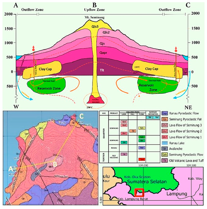
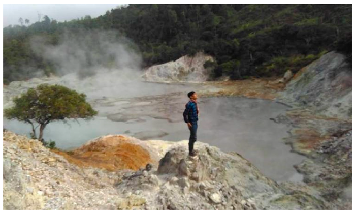
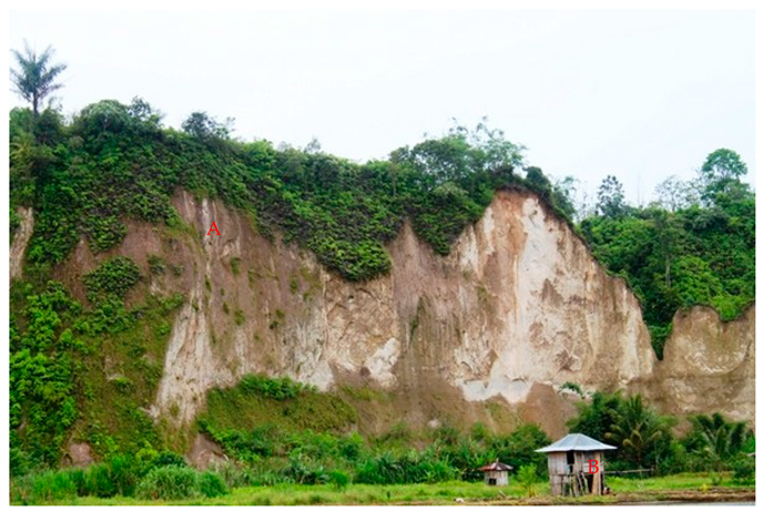
Several activities were carried out in this study, including a review of the geology and geopark literature, fieldwork, data analysis, and synthesis. Fieldwork was carried out in the West Lampung area to observe and characterize geological, ecological, and cultural sites by mapping, taking pictures, and collecting rock/soil samples from each site. The procedure includes inventory and identifying geodiversity for assessing geosites [18]. The study looked at rocks, outcrops, and geomorphology to formulate the geological history of the West Lampung region.
Following the Technical Guidelines for the Assessment of Geological Heritage Resources published by the Geological Survey Center of Indonesia [18], geosite assessment in Indonesian geoparks is based on weighting and scoring methods involving variables of scientific value (SV), the potential value for education (EV), the potential value for tourism (TV), and degradation risk (DV). Determination of geosite location is based on geological mapping, literature reviews, focused group discussions with local governments and communities, as well as engineering assessments.
The factors used in conducting a quantitative assessment of scientific values (SV), include: locations that represent the geological framework, key research locations, scientific understanding, geological site conditions, geological diversity, distribution of geological heritage sites within an area, and barriers to the use of site locations.
The factors used in conducting a quantitative assessment of educational values (EV) include: vulnerability of a geological heritage site to damage, location accessibility, barriers to site utilization, security facilities, supporting facilities, population density, relationships with other elements, location status, peculiarities, conditions in the observation of geological elements, potential for educational information, and geological diversity.
The factors used in conducting a quantitative assessment of tourism values (TV) include: the vulnerability of a geological heritage site, location achievement, barriers to site utilization, security facilities, supporting facilities, population density, relationships with other elements, location status, uniqueness, conditions on the observation of geological elements, interpretive potential, economic level, and proximity to recreation areas.
The factors used in conducting a quantitative assessment of the risk of degradation (DV) include: damage to geological elements, proximity to areas/activities that have the potential to cause degradation, legal protection, accessibility, and population density.
Each value and factor have its own weight. The weighting has been adjusted to the conditions and natural situations in Indonesia [18,19]. To simplify the textual material and help analysis, thematic maps were created using ArcGIS and other drawing applications. Furthermore, the overall geological features of the West Lampung region were compared to the worldwide geopark theme of the Ciletuh-Palabuhanratu UGGps. To reconstruct the geological history and assemble the theme, vision, and goal of West Lampung Aspiring Geopark, a synthesis of the results in the literature studies, field research, and data analysis were undertaken.

3. Results

The nomenclature used in this study for geodiversity includes geomorphology/landscapes, lithology/rocks and soils, and tectonics/geological structures which offer an overview of the distinct geological processes and illustrate the evolution of the region. Geodiversity is connected to the unique geological process for educational and conservation objectives as well as the economic usage of local people.
West Lampung Regency is located in the western part of Sumatra Island (Figure 2). This place has an altitude of 800 to 1100 masl, a steep and hilly topology, an average temperature of 24.5 °C, and an average humidity level of 86 percent [20]. This region is classified as a tropical wet climate according to the climatic classification [21]. The study area is traversed by the active Great Sumatran Fault (GSF) of Suoh-Komering Segment [22]. This fault is relatively trending northwest–southeast. Based on historical records [23,24], the fault has been a source of significant earthquakes and calamities in Sumatra (see Figure 2). The GSF has played an important role in shaping the landscape of the study area until now.
Geologically, the area of West Lampung and its surroundings is composed of Neogene–Quaternary volcanic rocks (Figure 3) which were deposited on mountains forming a structural denudational wavy volcanic hill morphology with moderate to very steep slopes. The drainage patterns that developed are dendritic, trellis, parallel, and radial. The southern part of the West Lampung area is dominated by volcanic rock types of sandy tuff and crystal glass tuff, which have loose characteristics, while the north, west, and east are dominated by residual soil resulting from weathering of volcanic material [20,26,27]. Based on the classification of volcanic facies, the study area is in the proximal facies [2,28]. This facies is predominantly composed of pyroclastic fall deposits, pyroclastic flows, and debris flows in the form of tuffaceous breccias, lapilli tuff, and lava.
The Great Sumatran Fault has shaped the surface of the study area. Tectono-volcanic evolution has produced distinctive and unique geological features. Volcanoes, fault valley/fault depression, geothermal manifestations, and volcano-tectonic craters and lakes are some of the geological features that are formed [3,7,17,29]. These features were formed in line with the evolution of Sumatra Island from the Carboniferous Age to the present [16,19,22,25,30,31].
Ranau, Sekincau, and Seminung Volcanoes are products of geological process in the study area (Figure 4). The Ranau caldera, according to Bellier et al. [32] and Bellier and Se’brier [33], is one of the main calderas located along the Sumatran Fault in south Sumatra (see Figure 3 and Figure 4). Its form and large size have been attributed to the geometric progression of the Great Sumatran Fault segmentation. It disintegrated amid an inactive along-strike Sumatran Fault pull-apart. Ranau caldera created one of Sumatra’s most common ignimbrite tuffs, known as Ranau tuff. Natawidjaja et al. [25] found that the Ranau Tuff’s revised 14C age shows that it was deposited during Sumatra’s youngest known major rhyolitic eruption. The development of the Ranau caldera can be summarized as follows [33]. The probable location of the Ranau caldera is bounded by a pull-apart basin created inside a large releasing step-over along with the strike-slip fault system with normal faults. Volcanic and geothermal activity occurred in this rectangular 12 × 16:5 km step-over of crustal instability zone. The creation of tiny calderas in the step-over was then seen. Later, increased volcanic activity resulted in additional caldera expansion. The last stage of caldera formation was most likely a paroxysmal tuff eruption that resulted in the collapse of the block bounded by the faults boundary. The pull-apart’s normal and strike-slip faults were changed to caldera boundary fractures. The extinction of Ranau step-over was indicated by the formation of a new fault across the pull-apart basin’s center portion. This fault correlates to the prominent active NW-trending strike-slip fault that crosses Ranau Lake and displaces recent geomorphic structures horizontally.
Mount Seminung is a volcano in the Ranau Lake caldera and located around 35 km northwest of the capital district of Liwa, West Lampung, Lampung Province, Sumatra, Indonesia. Mount Seminung rises around 1881 m above sea level. The mountain is located on the boundary between the two provinces of Lampung and South Sumatera. Ranau Lake is Sumatra’s second-biggest lake after Toba Lake in the North Sumatra Province [34]. Even though the height is not particularly high, the view from the mountain’s summit is breathtaking. Aside from the edelweiss blossoms, geothermal manifestations can also be found at its peak. Those manifestations may be seen around Ranau Lake [23,34] and have been used by the community as tourist destination for hot springs. The geothermal manifestation around Ranau Lake is a medium enthalpy field with a reservoir temperature of 200–220 °C. The productive zone (reservoir) area range is predicted to be between 14 and 17 km2. Based on the surface manifestation type and the silica-enthalpy mixing diagram result, the reservoir is projected to be liquid-dominated. According to the modified conceptual model, heat flow and mass circulate in the reservoir at a depth that flows up to the surface via the Talang Biak Fault and the Kota Batu Fault. This geothermal system’s infiltration and recharge zones are Suluh Hill and Ranau Lake. In a cooling stage, magma serves as a heat source for the Ranau Lake geothermal field (Figure 5) [23,34,35].
Mount Sekincau is a Quaternary volcano (Figure 6). The Sekincau region is located in the volcanic highlands of Bukit Barisan and is linked to the Great Sumatran Fault. Mount Sekincau is a dormant stratovolcanic andesitic volcanic complex with a juvenile dome-filled caldera and intermediate to silicic lava flows [36]. This region, specifically West Sekincau and East Sekincau (Gemburak Crater) has the potential for high-temperature geothermal energy (Figure 7). Tertiary and Quaternary volcanic rocks are most often found in the reservoir. Around the research area, the bedrock of Paleozoic and Mesozoic ages was discovered, consisting of low-grade meta-sedimentary rocks (slate, phyllite, quartzite) and granite intrusion. On the west edge of the crater, fumaroles and gas leaks were discovered, where the chemical composition is consistent with neutral and high temperature (>250 °C) geothermal energy sources [36]. Gemburak Crater, as a geothermal manifestation (Figure 7), is still in its natural condition as a tourism object and not yet fully utilized.
The Great Sumatran Fault depression formed into large valley after the extinction of the Ranau step-over period. The morphological appearance is of lake tuff deposits that form an elongated valley. At the bottom of the valley flows the Semangka River, while on the riverbank people use dry land to grow rice and for agriculture. There is also a rice barn made of soft mangrove wood, which local people call “Balai” (Figure 8B). The building serves to store crops and is a part of the cultural activities for the community.
Suoh was the epicenter of the Liwa major earthquakes in 1933 and 1994 [37]. This area is located in the southeast of Liwa Town as capital of West Lampung Regency (Figure 9). Located in the depression zone of the GSF, Suoh has geological features of lakes, craters, and geothermal manifestations (Figure 10A,B). The Suoh depression is thought to have arisen due to a fault jog in which the GSF zone is displaced dextrally by a pair of north–south faults. Young alluvium product (Qal) and Asam eruption deposits (Qae) are the major units. The dominant rock type in southwest of the Suoh depression is Tertiary Andesite (Tat). The Tekorberak Volcanic rock is located to the northeast of the depression (Qsdt). The Loreng Volcanic rock is the area’s youngest deposit (Qlr) [17]. The geological diversity in Suoh consists of Asam Lake, Lebar Lake, Minyak Lake, Nirwana Crater, Keramikan Crater, Kopi Susu Crater, Pasir Kuning, and Point View of Suoh Valley (see Figure 10A,B).

4. Discussion

For this study, 15 geological features in the West Lampung region were assessed by weighting and scoring methods with variables of scientific value (SV), education value (EV), tourism value (TV), and degradation value (DV) following the Technical Guidelines for the Assessment of Geological Heritage Resources published by the Geological Survey Center of Indonesia [18]. The quantitative assessment approach was applied [38]. It is explained in the guideline that the minimum value obtained <200 means that a percentage of the parameters assessed do not meet the criteria. On the other hand, the maximum possible value obtained is 400, meaning that the parameters assessed have met the geosite criteria. Meanwhile, values between 200 and 300 imply that the location can be designated as a geosite with various improvements.
The results of quantitative assessment are listed in Table 1. It shows that the Asam Lake, Nirwana Crater, and Point View of Suoh Valley in the Suoh part have the highest final values (>300), followed by Batubrak Fault Depression. The Batubrak Fault Depression and Asam Lake have significant scientific and tourist value (>80), particularly in terms of portrayal, uniqueness, perspectives, scenery, and natural surroundings. In the Suoh Section, Nirwana Crater, Kopi Susu Crater, Keramikan Crater, and Point View of Suoh Valley have significant scientific importance (>80) but low educational and tourism values (<80), while the other sites have low values (<80), thus placing the area at the bottom of the assessment even though overall they are of medium value (200–300). Geosites in West Lampung have low value due to factors such as location accessibility, tourism infrastructure, and location management. In addition to the foregoing, the Bukit Barisan Selatan National Park (TNBBS) has various geosites, which have a low value owing to delays in visits due to the entry permission. Looking at the total findings, it can be seen that basic tourism infrastructure, visitor center, and tour guide services, as well as promotional efforts, are important factors in attracting more tourists to the West Lampung geosites. This issue must be the primary emphasis of geosite management to attract more tourists in the future. However, further investment and enhancement in terms of tourism value are required. This is particularly true for tour guide services, informative panels, lodging, and restaurant services. Furthermore, strong geosite management with the TNBBS must be developed so that the low value may be remedied.
The majority of the procedures used to compile the initial inventories were focused on providing data for identification, location, categorization, and assessment [39], which are typically included in the total value, similar to the standards used in Indonesia today. In fact, not all the assessed sites yield a good total score from all values. There are sites that are good in terms of scientific aspects but not good in terms of educational aspects, such as Asam Lake, Nirwana Crater, Keramikan Crater, and Kopi Susu Crater. Sites that are good in terms of tourism but have poor value in terms of education are, for example, Pasir Kuning River and Batubrak Fault Depression. Therefore, a broad view is needed from all parties so that the site can be assessed from all sides so that its designation is clearly known, i.e., whether the geosite is for scientific, educational, or only for tourism purposes, or even for all of them.
Based on its history, the study area is a geological hazard-prone area for earthquakes, landslides, and floods. Geodiversity aspects give advantages whether or not extraction is required. Because these services support society in a number of ways, geodiversity is seen as a natural resource whose management is crucial to meeting global goals such as the United Nations Sustainable Development Goals–2030 Agenda [40]. These hazards can be viewed as chances to learn more about the size of natural processes and the influence of human variables, including risk exposure. Muslim et al. [41] mentioned in their paper that for certain geosites in Ciletuh-Palabuhanratu UGGp, behind the natural beauty of geological features there are several potential hazards that might occur in the future. This concern of risk exposure affects the value of geosites based on the local conditions. Earthquakes and their collateral damage such as landslides and liquefaction are indispensable for the population and infrastructures development toward the safe livable built environment around the study area. Therefore, disaster mitigation is very important when those geological hazards occur in the study area. There are many ways to increase disaster mitigation for the community, but the most important aspect is the education sector. The education stakeholders on disaster mitigation are important actors to support community-based disaster risk mitigation (CBDRM) for creating a disaster resilient community since the establishment of geoparks will attract more tourists and visitors to this area than before.
The geosite is generally located in a village where schools are the central point of activity for the local people. This condition has made the geosites as the central of activity for people during weekdays, weekends, and even holidays. Scenarios for disaster management are extremely important to face unexpected geological events when there are crowds of people [41]. When it happens, the emergency response phase could be more difficult if the people are not well prepared. This issue is closely related to educational values for several geosites in the study area.
The scientific values of geological features are important for academia (lecturers and university students) but not of interest to the public. Matsumoto et al. [42] analyzed the awareness and preparedness level of university students in Indonesia and Japan with regard to the natural disasters. The results suggest that Indonesian students have a higher level of disaster preparedness, but they underestimate the possibility of disaster, and Japanese students feel a strong possibility of disaster happening, but they have low capability to cope with disasters. This result highlights the role of academia in enhancing the scientific values of geosites as well as supporting disaster awareness and preparedness among local communities.
The tourism values of geosites are supported by the active role of local communities, where cultural attractions such as art performances, local food and culinary attractions are provided for the tourists. Haerani et al. [43] mentioned that empowering local people is very important for tourism as well as raising awareness of the community for conservation ideas to support sustainable urban or tourism development. The disputes between the exploitation of resources, such as with the mining industry and conservation, to maintain the safe and healthy environment are observed and local wisdom or knowledge are utilized to support the effort for disaster risk reduction or mitigation through development of geotourism. To maintain this sustainable effort, it is necessary to educate all stakeholders, including local and provincial governments, industry, communities, etc.
The degradation risk values are important factors to maintain sustainability of the geosite objects and tourism industry itself. Stakeholders of disaster management, such as pentahelix pillars such as academia, business, community, government, and media (ABCGM), are available in the study area. These pentahelix pillars are important players to reduce the degradation risk values. Risk reduction activities can be combined with disaster mitigation (CBDRM), local empowerment, and community resilience. Special attention is paid to the local school communities (students, teachers, and parents) where they live around the geosite premises. It is important that these stakeholders have a reasonable understanding of maintaining the sustainability of a particular geosite, even though local school communities generally have limited disaster education opportunities and knowledge, which could imply a low level of awareness. To overcome this limitation, dissemination of entry level of Earth science is deeply needed for local education communities since there is no such subject (especially geology) in primary- to secondary-level schools in Indonesia [44].

5. Conclusions

Undoubtedly, the West Lampung region offers some outstanding geosites with significant geotourism development potential. As mentioned in the previous paragraphs, the natural resources needed for geotourism development are already available, and it is just a matter of how to manage the geosite into an attractive tourist attraction.
The study area is prone to earthquake hazards, and major earthquakes occurred in 1933 and 1994. So, the management of geosites with the theme of geodisaster (geodisaster tourism) can be proposed.
The public or visitors can be presented with the beauty of nature as well as learn the history of the formation of the West Lampung area. Non-structural disaster/mitigation education can also be carried out as well. Interpreters/tour guides can explain the diversity of nature, potential disasters, and how to use them to become valuable knowledge for visitors/local communities.
West Lampung geohistory packages, geotrail activities with the community, and geocamping in nature are some ways to promote geosites effectively. Other things such as sign board, printed materials, and social media can also be provided.
Further research should mainly concentrate on the most effective management models and promotion efforts for the planned geosites and geotourism zones. Furthermore, more emphasis should be placed on the interpretation potential and selection of the most appropriate technique for geosite interpretation considering that the area of West Lampung is prone to geological disasters.

Author Contributions

Conceptualization, D.M. and P.I.; methodology, Z.Z., P.I., D.M. and H.R.; writing—review and editing, P.I., D.M. and M.S.S.; visualization, G.O.M. and F.N.M.; project administration, D.M. and G.O.M.; funding acquisition, D.M. All authors have read and agreed to the published version of the manuscript.

Funding

This research is a collaboration between the Faculty of Geological Engineering, Padjadjaran University (166/UN6.P/PKS/2022) and the Regional Research and Development Agency, West Lampung, Indonesia (070/12/PPK/IV.05/2022).

Data Availability Statement

Not applicable.

Acknowledgments

In particular, we would like to thank Paijo, Sadikin, and Yudi for their cooperation.

Conflicts of Interest

The authors declare no conflict of interest.

References

  1. Metcalfe, I. Tectonic Evolution of Sundaland. Bull. Geol. Soc. Malays. 2017, 63, 27–60. [Google Scholar] [CrossRef] [Green Version]
  2. Williams, H.; McBirney, A.R. Volcanology. In Volcanology; Jones & Bartlett Learning: Burlington, MA, USA, 1980. [Google Scholar]
  3. Iqbal, M.; Juliarka, B.R. Analisis Kerapatan Kelurusan (Lineament Density) Di Lapangan Panasbumi Suoh-Sekincau, Lampung. J. Sci. Appl. Technol. 2019, 3, 31–67. [Google Scholar] [CrossRef] [Green Version]
  4. Sonter, L.J.; Ali, S.H.; Watson, J.E.M. Mining and Biodiversity: Key Issues and Research Needs in Conservation Science. Proc. R. Soc. B Biol. Sci. 2018, 285, 1892. [Google Scholar] [CrossRef] [PubMed] [Green Version]
  5. Kementerian ESDM. Guidelines for Determining Geological Heritage (Geoheritage) Regulation No 1 of the Minister of Energy and Mineral Resources of the Republic of Indonesia. 2020. Available online: https://jdih.esdm.go.id/storage/document/Permen%20ESDM%20Nomor%201%20Tahun%202020-ocr.pdf (accessed on 10 November 2022).
  6. Herrera-Franco, G.; Montalván-Burbano, N.; Carrión-Mero, P.; Jaya-Montalvo, M.; Gurumendi-Noriega, M. Worldwide Research on Geoparks through Bibliometric Analysis. Sustainability 2021, 13, 1175. [Google Scholar] [CrossRef]
  7. Wibowo, R.C.; Sarkowi, M.; Setiawan, A.F.; Yudamson, A.; Kurniawan, M.; Arifianto, I. Flash Flood Hazard Areas Assessment in Bandar Negeri Suoh (BNS) Region Using an Index Based Approaches and Analytical Hierarchy Process. J. Phys. Conf. Ser. 2020, 1434, 012006. [Google Scholar] [CrossRef]
  8. Newsome, D.; Dowling, R. The scope and nature of geotourism. In Geotourism; Dowling, R., Newsome, D., Eds.; Routledge: London, UK, 2005; pp. 3–25. [Google Scholar]
  9. La Fua, J. Manajemen Pemanfaatan Sumber Daya Alam Di Indonesia Untuk Mendukung Pembangunan Berkelanjutan Melalui Pendekatan Ekonomi Hijau. Shautut Tarb. 2015, 21, 57–76. [Google Scholar]
  10. Henley, D.; Schulte Nordholt, H.G.C. History and Seismology in the Ring of Fire: Punctuating the Indonesian Past. In Environment, Trade and Society in Southeast Asia; Brill: Leiden, The Netherlands, 2015. [Google Scholar] [CrossRef] [Green Version]
  11. Farsani, N.T.; Coelho, C.O.; Costa, C.M.; Amrikazemi, A. Geo-knowledge management and geoconservation via ge-oparks and geotourism. Geoheritage 2014, 6, 185–192. [Google Scholar] [CrossRef]
  12. Brilha, J. Inventory and quantitative assessment of geosites and geodiversity sites: A review. Geoheritage 2016, 8, 119–134. [Google Scholar] [CrossRef] [Green Version]
  13. Ansori, C.; Setiawan, N.I.; Warmada, I.W.; Yogaswara, H. Identification of Geodiversity and Evaluation of Geosites to Determine Geopark Themes of the Karangsambung-Karangbolong National Geopark, Kebumen, Indonesia. Int. J. Geoherit. Park. 2022, 10, 1–15. [Google Scholar] [CrossRef]
  14. Migoń, P.; Pijet-Migoń, E. Natural Disasters, Geotourism, and Geo-Interpretation. Geoheritage 2019, 11, 629–640. [Google Scholar] [CrossRef]
  15. Çetiner, Z.S.; Ertekin, C.; Yiğitbaş, E. Evaluating Scientific Value of Geodiversity for Natural Protected Sites: The Biga Pen-insula, Northwestern Turkey. Geoheritage 2017, 10, 49–65. [Google Scholar] [CrossRef]
  16. Sieh, K.; Natawidjaja, D. Neotectonics of the Sumatran Fault, Indonesia. J. Geophys. Res. Solid Earth 2000, 105, 28295–28326. [Google Scholar] [CrossRef] [Green Version]
  17. Hidayatika, A.; Utami, P.; Suharno, S.; Amukti, R. Analysis of Thermal Manifestation in Suoh West Lampung Indonesia. In Proceedings of the World Geothermal Congress, Melbourne, Australia, 19–25 April 2015. [Google Scholar]
  18. Geological Survey Center of Indonesia. Technical Standards for Inventory of Geological Diversity and Identification of Geological Geritage; Indonesian Geological Agency: Bandung, Indonesia, 2017; p. 11. [Google Scholar]
  19. Gobbett, D.J.; Hutchinson, C.S. Geology of the Malay Peninsula; Ed. Wiley-Interscience. 1973. J. Geogr. (Chigaku Zasshi) 1973, 82, 219–220. [Google Scholar] [CrossRef]
  20. Iqbal, P.; Muslim, D.; Zakaria, Z.; Permana, H.; Jaya Syahbana, A.; Aji Satriyo, N.; Yunarto, Y.; Jakah, J.; Khoirullah, N. Tropical Volcanic Residual Soil. Prog. Volcanol. 2022, 3, 63–83. [Google Scholar] [CrossRef]
  21. Hurukawa, N.; Wulandari, B.R.; Kasahara, M. Earthquake History of the Sumatran Fault, Indonesia, since 1892, Derived from Relocation of Large Earthquakes. Bull. Seismol. Soc. Am. 2014, 104, 1750–1762. [Google Scholar] [CrossRef]
  22. Natawidjaja, D.H. Updating Active Fault Maps and Sliprates along the Sumatran Fault Zone, Indonesia. In Proceedings of the IOP Conference Series: Earth and Environmental Science, Bandung, Indonesia, 18–19 October 2017; IOP Publishing: Bristol, UK, 2018; Volume 118, p. 012001. [Google Scholar] [CrossRef] [Green Version]
  23. Rera, G.F.; Pratama, H.B.; Saptadji, N.M. Approach for Pre-Feasibility Study of Medium Enthalpy Geothermal Field, Case Study: Danau Ranau, Indonesia. In Proceedings of the IOP Conference Series: Earth and Environmental Science, Bandung, Indonesia, 10–13 August 2020; IOP Publishing: Bristol, UK, 2021; Volume 732, p. 012021. [Google Scholar] [CrossRef]
  24. USGS. Available online: https://earthquake.usgs.gov/ (accessed on 31 August 2022).
  25. Natawidjaja, D.H.; Bradley, K.; Daryono, M.R.; Aribowo, S.; Herrin, J. Late Quaternary Eruption of the Ranau Caldera and New Geological Slip Rates of the Sumatran Fault Zone in Southern Sumatra, Indonesia. Geosci. Lett. 2017, 4, 21. [Google Scholar] [CrossRef] [Green Version]
  26. Iqbal, P.; Muslim, D.; Zakaria, Z.; Permana, H.; Syahbana, A.J.; Yunarto, J. Geotechnical Characteristics of Volcanic Red Clay Soil Related to Geoengineering Problem in Sekincau, Sumatra, Indonesia. Int. J. Adv. Sci. Technol. 2020, 29, 3166–3173. [Google Scholar]
  27. Iqbal, P.; Muslim, D.; Zakaria, Z.; Permana, H.; Satriyo, N.A.; Syahbana, A.J.; Yunarto; Khoirullah, N.; Asykarullah, A.W. Swelling Potential of Volcanic Residual Soils in Sumatra (Indonesia) in Relation to Environmental Issues. Environ. Socio-Econ. Stud. 2020, 8, 4. [Google Scholar] [CrossRef]
  28. Bogie, I.; Mackenzie, K.M. The Application of a Volcanic Facies Model to an Andesitic Stratovolcano Hosted Geothermal System at Wayang Windu, Java, Indonesia. In Proceedings of the 20th NZ Geothermal Workshop; University of Auckland: Auckland, New Zealand, 1998; pp. 265–276. [Google Scholar]
  29. Aribowo, S. The Geometry of Pull-Apart Basins in the Southern Part of Sumatran Strike-Slip Fault Zone. In Proceedings of the IOP Conference Series: Earth and Environmental Science, Bandung, Indonesia, 18–19 October 2017; IOP Publishing: Bristol, UK, 2018; Volume 118, p. 012002. [Google Scholar] [CrossRef]
  30. Barber, A.J.; Crow, M.J. An Evaluation of Plate Tectonic Models for the Development of Sumatra. Gondwana Res. 2003, 6, 1–28. [Google Scholar] [CrossRef]
  31. Barber, A.J.; Crow, M.J.; Milsom, J. (Eds.) Sumatra: Geology, Resources and Tectonic Evolution (References); Geological Society of London: London, UK, 2005; Volume 21. [Google Scholar]
  32. Bellier, O.; Bellon, H.; Sébrier, M.; Maury, R.C. K-Ar Age of the Ranau Tuffs: Implications for the Ranau Caldera Emplacement and Slip-Partitioning in Sumatra (Indonesia). Tectonophysics 1999, 312, 347–359. [Google Scholar] [CrossRef]
  33. Bellier, O.; Sébrier, M. Relationship between Tectonism and Volcanism along the Great Sumatran Fault Zone Deduced by Spot Image Analyses. Tectonophysics 1994, 233, 215–231. [Google Scholar] [CrossRef]
  34. Idianto, O.; Rera, G.F.; Wardoyo, G.K.; Pratama, H.B.; Hamdani, M.R. Updated Conceptual Model and Resource Assessment Using Numerical Reservoir Simulation of Danau Ranau Geothermal Field Indonesia. In Proceedings of the IOP Conference Series: Earth and Environmental Science, Bandung, Indonesia, 10–13 August 2020; IOP Publishing: Bristol, UK, 2021; Volume 732, p. 012027. [Google Scholar] [CrossRef]
  35. Indrayati, I.; Lestari, F.; Kadafi, I.O. Kajian Pengembangan Kelembagaan & Pembiayaan Geopark Di Indonesia. 2021. Available online: http://repository.iti.ac.id/handle/123456789/821 (accessed on 10 September 2022).
  36. Direktorat Panas Bumi. Potensi Panas Bumi Indonesia Jilid 1. Direktorat Jenderal Energi Baru, Terbarukan dan Konservasi Energi, Kementerian Energi dan Sumber Daya Mineral, Indonesia. 2017. Available online: https://ebtke.esdm.go.id/post/2017/09/25/1751/buku.potensi.panas.bumi.2017 (accessed on 18 September 2022). (In Indonesian).
  37. Soehaimi, A.; Muslim, D.; Kamawan, I.; Negara, R.S. Microzonation of the Liwa City on the Great Sumatera Active Fault and Giant Ranau Volcanic Complex in South Sumatera, Indonesia. In Engineering Geology for Society and Territory-Volume 5: Urban Geology, Sustainable Planning and Landscape Exploitation; Springer: Berlin, Germany, 2015. [Google Scholar] [CrossRef]
  38. Golfinopoulos, V.; Papadopoulou, P.; Koumoutsou, E.; Zouros, N.; Fassoulas, C.; Zelilidis, A.; Iliopoulos, G. Quantitative Assessment of the Geosites of Chelmos-Vouraikos UNESCO Global Geopark (Greece). Geoscientifics 2022, 12, 63. [Google Scholar] [CrossRef]
  39. Massonnet, D.; Feigl, K.L. Radar Interferometry, and Its Application to Changes in the Earth’s Surface. Rev. Geophys. 1998, 36, 441–500. [Google Scholar] [CrossRef] [Green Version]
  40. García-Cortés, A.; Vegas, J.; Carcavilla, L.; Diaz-Martinez, E. Conceptual Base and Methodology of the Spanish Inventory of Sites of Geological Interest (Ielig); Instituto Geológico y Minero de España: Madrid, Spain, 2019; p. 102. [Google Scholar]
  41. Muslim, D.; Haerani, E.; Muslim, F.N.; Muslim, G.O. Toward the safe live-able built environment around Ciletuh-Palabuhanratu Geopark Area in Sukabumi Regency, Indonesia. In Proceedings of the IOP Conference Series: Earth and Environmental Science, Bandung, Indonesia, 18–19 October 2017; IOP Publishing: Bristol, UK, 2019; Volume 248, p. 012036. [Google Scholar] [CrossRef]
  42. Matsumoto, M.; Sasaki, T.; Muslim, D. A study on the level of disaster awareness and preparedness between Indonesian and Japanese students. J. Jpn. Soc. Civ. Eng. Ser. F6 (Saf. Probl.) 2018, 74, 53–62. [Google Scholar] [CrossRef]
  43. Haerani, E.; Muslim, F.N.; Muslim, G.O.; Muslim, D. Human Resources in the Urban Environment of Citatah Mining Area, West Bandung Regency, Indonesia. In Proceedings of the IOP Conference Series: Earth and Environmental Science, Bandung, Indonesia, 25–26 October 2018; IOP Publishing: Bristol, UK, 2019; Volume 248, p. 012042. [Google Scholar] [CrossRef]
  44. Dicky, M.; Haerani, E.; Shibayama, M.; Ueshima, M.; Kagawa, N.; Hirnawan, F. Disaster Awareness Education for Children in Schools Around Geological Hazard Prone Areas in Indonesia. In Engineering Geology for Society and Territory-Volume 6; Springer Cham: Berlin, Germany, 2015; pp. 107–111. [Google Scholar] [CrossRef]
Figure 1. Location of Indonesian global and national geoparks (modified from [13]).
Resources 11 00104 g001
Figure 2. West Lampung and its surrounding area, which is traversed by the Great Sumatran Fault (GSF) (modified from [25]).
Resources 11 00104 g002
Figure 3. Regional geological map of study area (modified from [2,17]).
Resources 11 00104 g003
Figure 4. Mount Seminung and Ranau Lake.
Resources 11 00104 g004
Figure 5. Conceptual model of Ranau Lake geothermal field (modified from [34]).
Resources 11 00104 g005
Figure 6. Mount Sekincau in West Lampung, Indonesia.
Resources 11 00104 g006
Figure 7. Gemburak Crater in Mount Sekincau, West Lampung.
Resources 11 00104 g007
Figure 8. A. Fault depression plane and B. example of ‘Balai’ in the valley of Sumatran Great Fault.
Resources 11 00104 g008
Figure 9. Suoh depression zone of the Great Sumatran Fault.
Resources 11 00104 g009
Figure 10. The features of geological diversity in Suoh ((A) Asam Lake and (B) geothermal manifestation of Keramikan Crater).
Resources 11 00104 g010
Table 1. Overall values of the analyzed geosites by technical guidelines [18].
NoGeositeLong. (E)Lat. (S)Scientific
Value
Education
Value
Tourism
Value
Degradation
Risk Value
Final
Value
1Asam Lake104.278166°−5.238389°102.2876.2591.2576.25346.03
2Lebar Lake104.271500°−5.247194°77.7782.576.2552.5289.02
3Minyak lake104.265333°−5.247167°75.2782.57038.75266.52
4Nirwana Crater104.259520°−5.237197°91.0363.7571.2582.5308.53
5Keramikan Crater104.263487°−5.239270°94.1556.2571.2560281.65
6Kopi Susu Crater104.262807°−5.239689°86.0356.2552.558.75253.53
7Pasir Kuning River104.267649°−5.236443°74.0372.57543.75265.28
8Point View Suoh Valley104.239794°−5.260760°95.7672.562.573.75304.51
9Gemburak Geothermal104.3452°−5.0974°74.6566.256053.75254.65
10Bidadari Waterfall103.825689°−4.924613°53.2751.2551.2548.75204.52
11Lava Gantung103.833471°−4.924572°47.0142.548.7572.5210.76
12Lava Andesit103.930140°−4.944303°58.2642.548.7576.25225.76
13Jagaraga 104.008535°−4.920894°58.2642.548.7576.25225.76
14Batubrak Fault Depression104.16776°−5.00982°103.2768.758095347.02
15Tuff site, Lembah Batubrak104.16776°−5.00982°74.6566.2561.2553.75255.9
Publisher’s Note: MDPI stays neutral with regard to jurisdictional claims in published maps and institutional affiliations.

