
Long-Term Changes, Inter-Annual, and Monthly Variability of Sea Level at the Coasts of the Spanish Mediterranean and the Gulf of Cádiz

 , , ,
, , ,
Abstract
:1. Introduction
2. Data and Methods
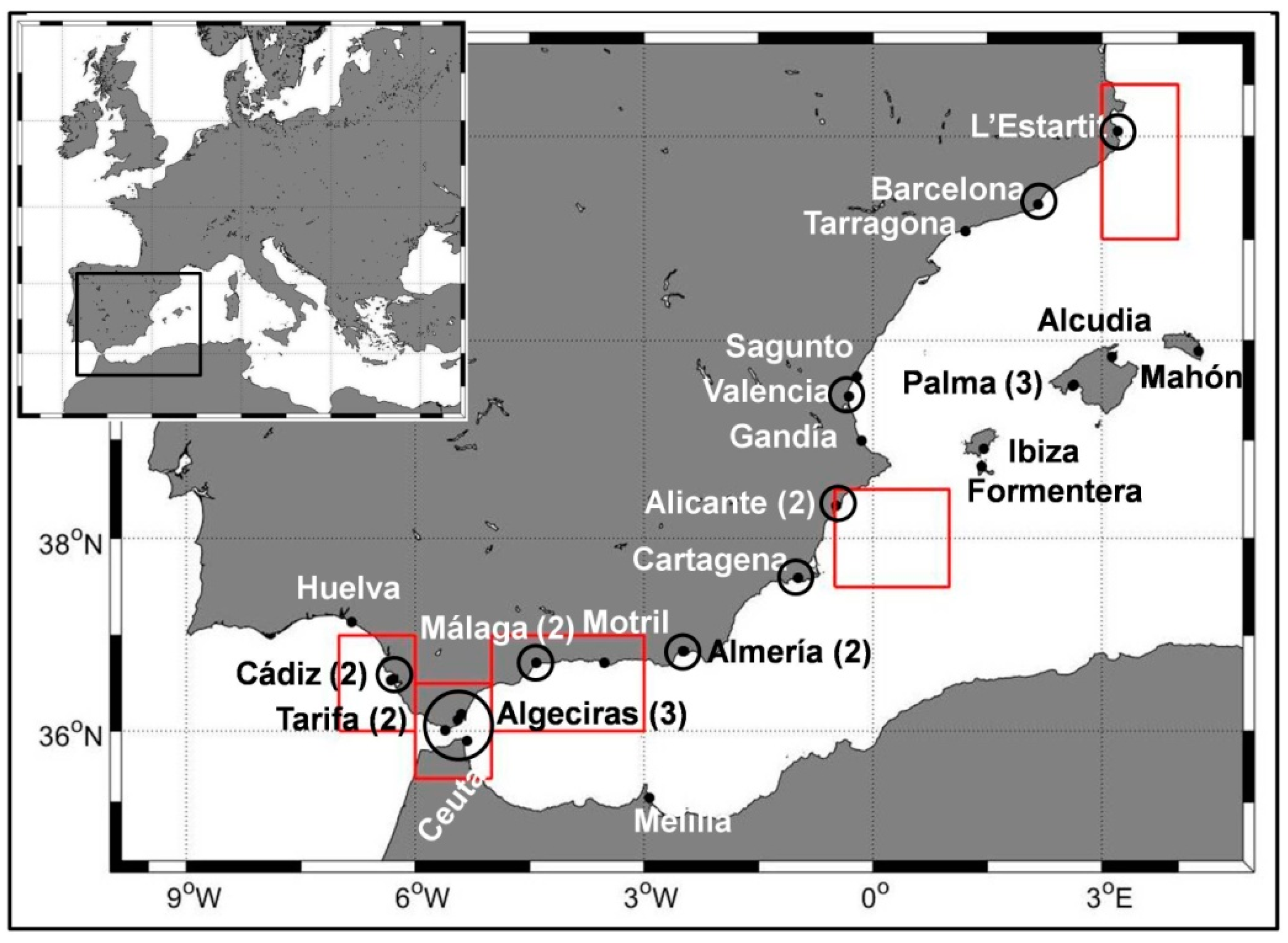
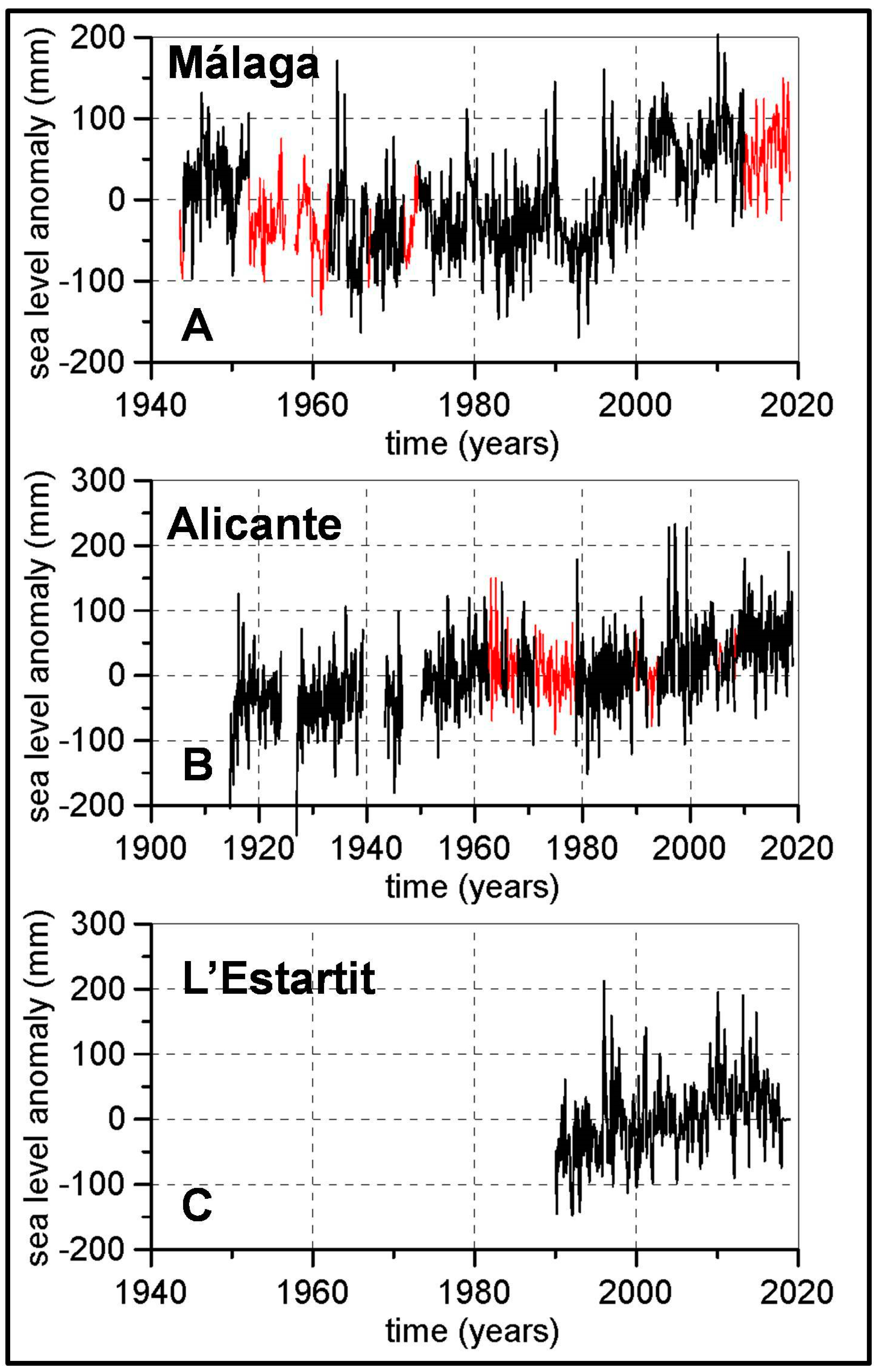
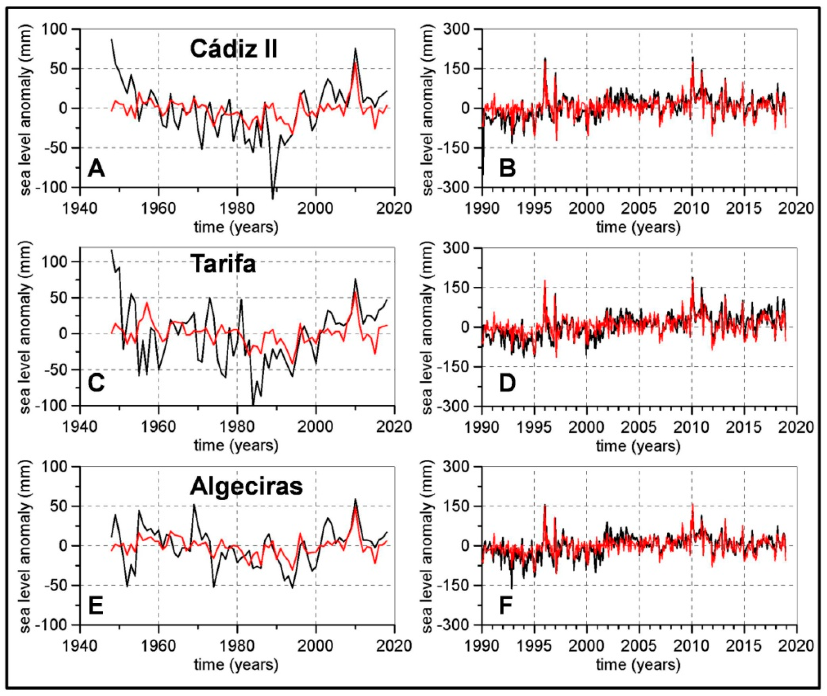
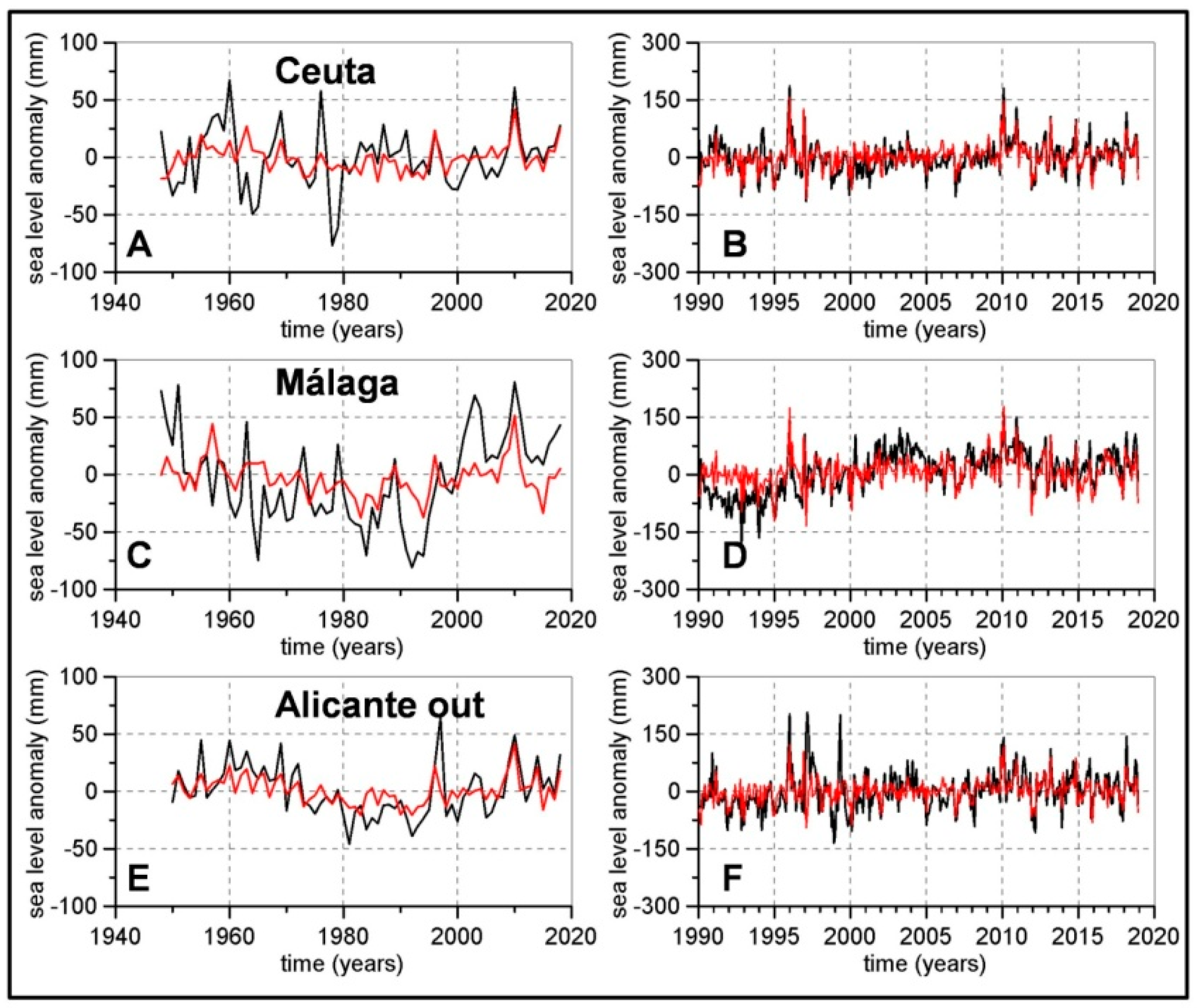
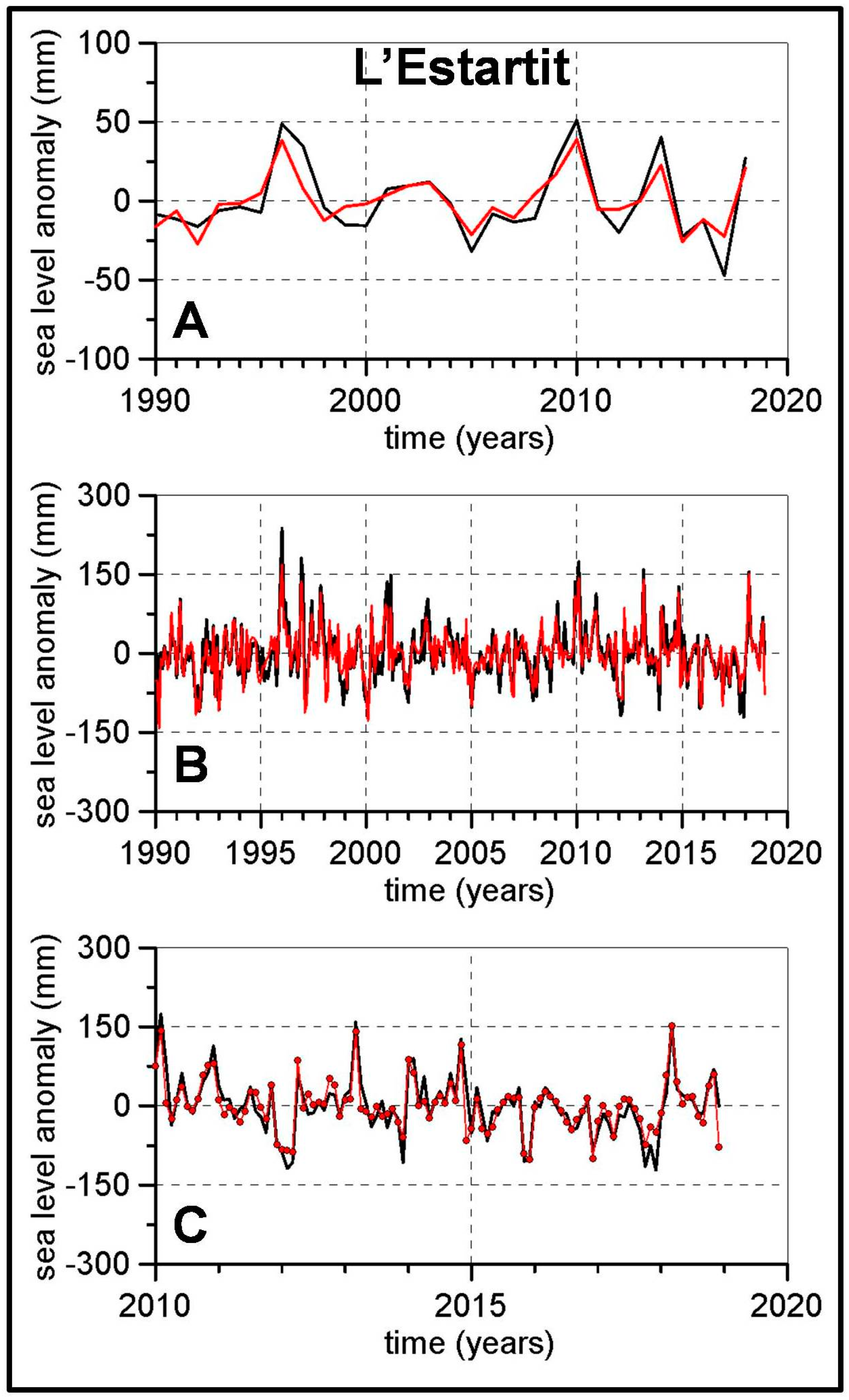
2.1. Dataset
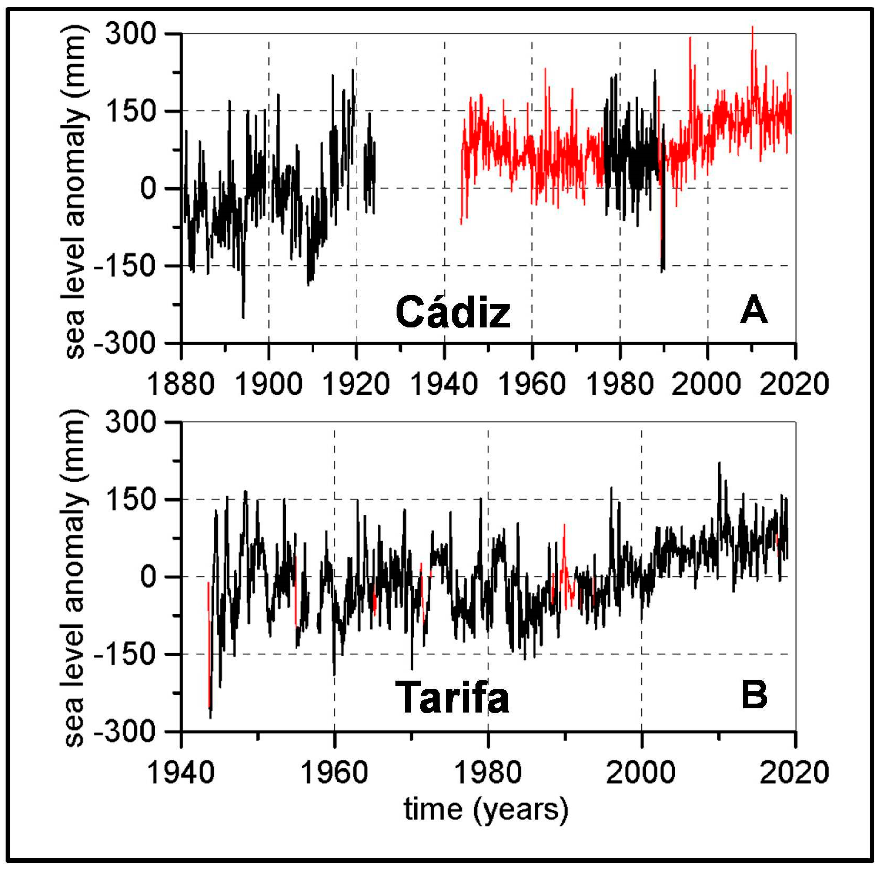
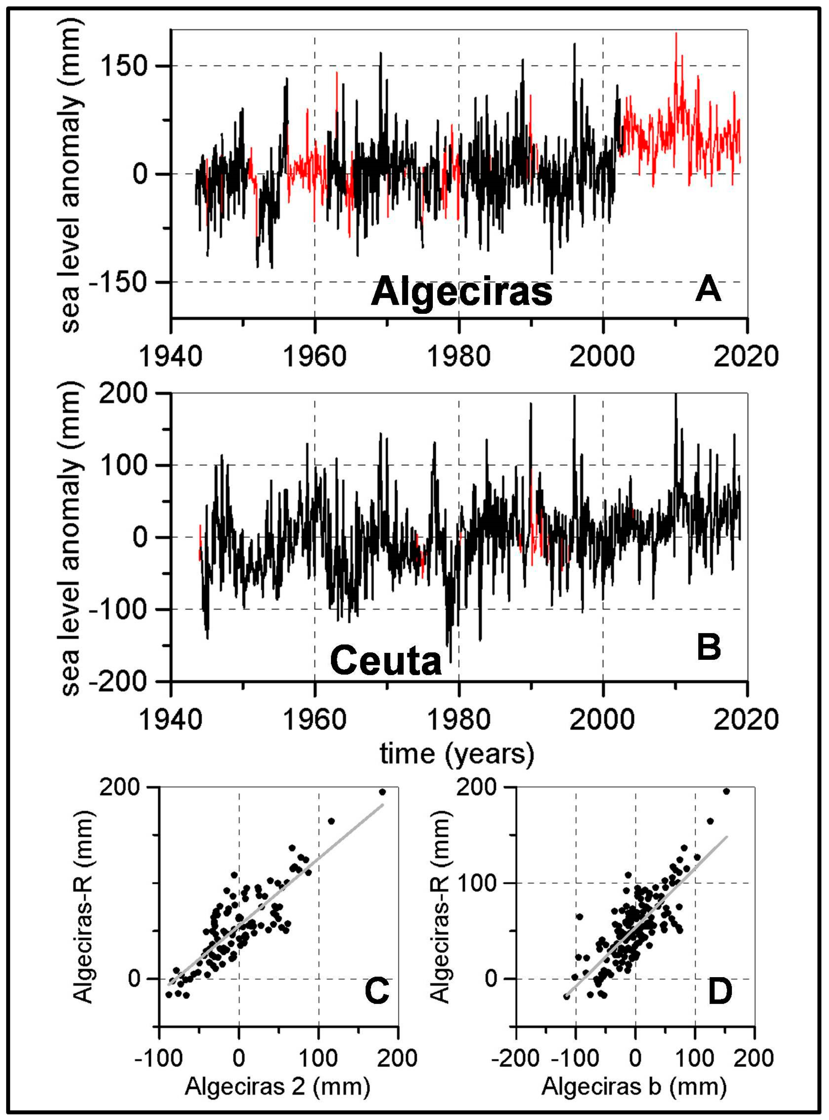
2.2. Reconstruction of Long Time Series
2.3. Pressure and Wind Data
2.4. Steric Component of Sea Level
2.5. Estimation of Linear Trends
2.6. Statistical Model
3. Results
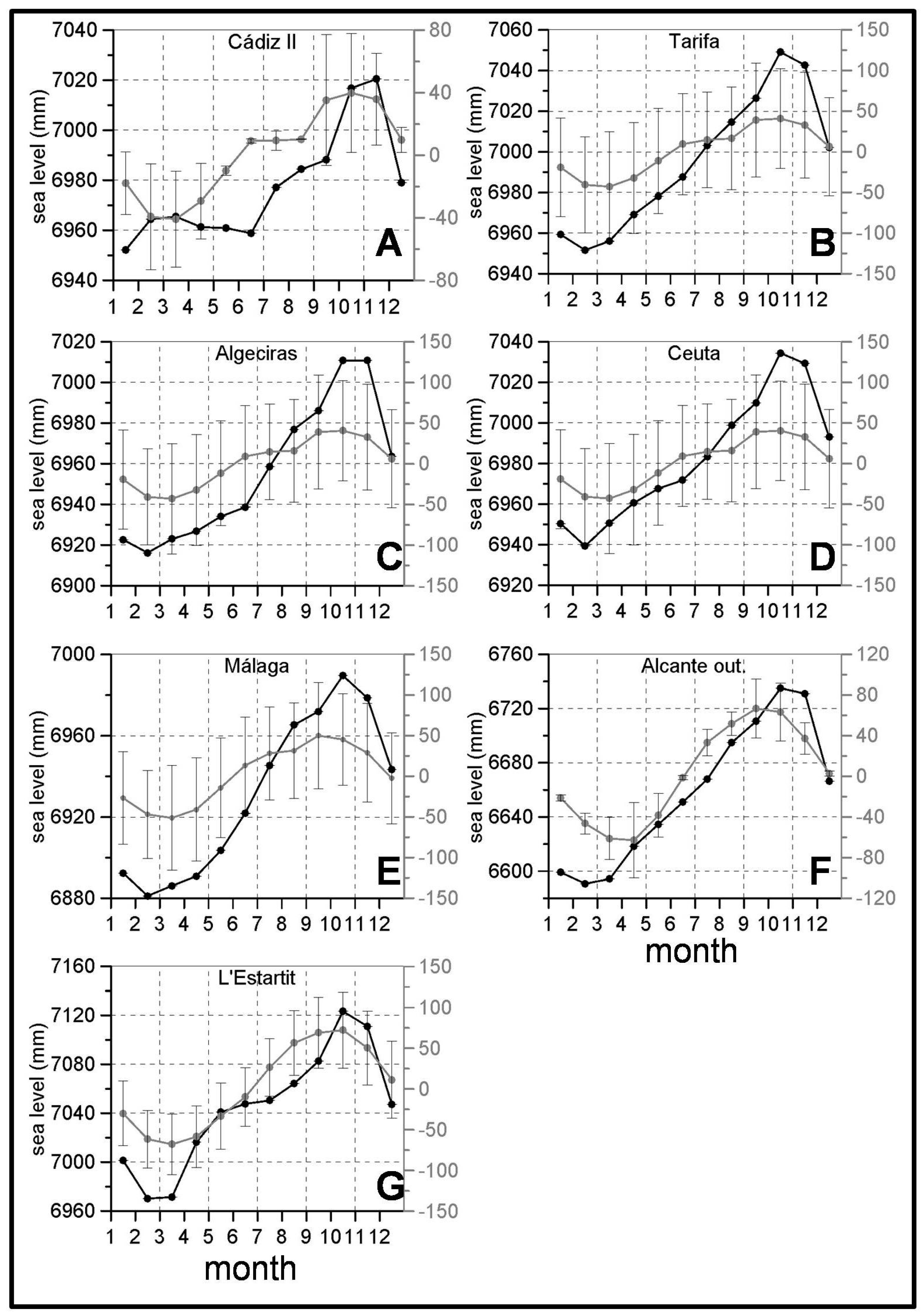
3.1. Seasonal Cycles
3.2. Linear Trends
3.3. Inter-Annual Variability—Linear Model
4. Discussion and Summary
Supplementary Materials
Author Contributions
Funding
Data Availability Statement
Acknowledgments
Conflicts of Interest
References
- Oppenheimer, M.; Glavovic, B.C.; Hinkel, J.; van de Wal, R.; Magnan, A.K.; Abd-Elgawad, A.; Cai, R.; Cifuentes-Jara, M.; de Conto, R.M.; Ghosh, T.; et al. Sea Level Rise and Implications for Low-Lying Islands, Coasts and Communities. In IPCC Special Report on the Ocean and Cryosphere in a Changing Climate; Pörtner, H.-O., Roberts, D.C., Masson-Delmotte, V., Zhai, P., Tignor, M., Poloczanska, E., Mintenbeck, K., Alegría, A., Nicolai, M., Okem, A., et al., Eds.; IPCC: Geneva, Switzerland, 2019; in press. [Google Scholar]
- IMBIE Team. Mass balance of the Greenland Ice Sheet from 1992 to 2018. Nature 2020, 579, 223–239. [Google Scholar] [CrossRef]
- Rignot, E.; Mouginot, J.; Scheuchl, B.; van den Broeke, M.; van Wessem, M.J.; Morlighem, M. Four decades of Antarctic Ice sheet balance from 1979–2017. Proc. Natl. Acad. Sci. USA 2019, 116, 1095–1103. [Google Scholar] [CrossRef] [Green Version]
- Calafat, F.M.; Chambers, D.P.; Tsimplis, M.N. On the ability of global sea level reconstructions to determine trends and variability. J. Geophys. Res. Ocean. 2014, 119, 1572–1592. [Google Scholar] [CrossRef] [Green Version]
- Church, J.A.; White, N.J. Sea-level rise from late 19th to early 21st century. Surv. Geophys. 2011, 32, 585–602. [Google Scholar] [CrossRef] [Green Version]
- Llovel, W.; Cazenave, A.; Rogel, P.; Lombard, A.; Bergé-Nguyen, M. 2-D reconstruction of past sea level (1950–2003) using tide gauge records and spatial patterns from a general ocean circulation model. Clim. Past Discuss. 2009, 5, 1109–1132. [Google Scholar] [CrossRef] [Green Version]
- Church, J.A.; White, N.J. A 20th century acceleration in global sea level rise. Geophys. Res. Lett. 2006, 33, L01602. [Google Scholar] [CrossRef]
- Church, J.A.; White, N.J.; Coleman, R.; Lambeck, K.; Mitrovica, J.X. Estimates of the Regional Distribution of Sea Level Rise over the 1950–2000 Period. J. Clim. 2004, 17, 2609–2625. [Google Scholar] [CrossRef]
- Jevrejeva, S.; Moore, J.C.; Grinsted, A.; Woodworth, P.L. Recent global sea level acceleration started over 200 years ago? Geophys. Res. Lett. 2008, 35, L08715. [Google Scholar] [CrossRef]
- Gomis, D.; Tsimplis, M.; Marcos, M.; Fenoglio-Marc, L.; Pérez, B.; Raicich, F.; Vilibic, I.; Wöppelmann, G.; Monserrat, S. Mediterranean Sea-Level Variability and Trends. In The Climate of the Mediterranean Región: From the Past to the Future; Lionello, P., Ed.; Elsevier: Amsterdam, The Netherlands, 2012. [Google Scholar]
- Calafat, F.M.; Jordà, G.A. Mediterranean sea level reconstruction (1950–2008) with error budget estimates. Glob. Planet. Chang. 2011, 79, 118–133. [Google Scholar] [CrossRef]
- Calafat, F.M.; Gomis, D.; Marcos, M. Comparison of Mediterranean sea level fields for the period 1961–2000 as given by a data reconstruction and 3D model. Glob. Planet. Chang. 2009, 68, 175–184. [Google Scholar] [CrossRef] [Green Version]
- Calafat, F.M.; Gomis, D. Reconstruction of Mediterranean sea level fields for the period 1945–2000. Glob. Planet. Chang. 2009, 66, 225–234. [Google Scholar] [CrossRef] [Green Version]
- Marcos, M.; Tsimplis, M.N. Forcing of coastal sea level rise patterns in the North Atlantic and the Mediterranean Sea. Geophys. Res. Lett. 2007, 34, L18604. [Google Scholar] [CrossRef]
- Tsimplis, M.N.; Josey, S.A. Forcing of the Mediterranean Sea by atmospheric oscillations over the North Atlantic. Geophys. Res. Lett. 2001, 28, 803–806. [Google Scholar] [CrossRef] [Green Version]
- Tsimplis, M.N.; Baker, T.F. Sea level drop in the Mediterranean Sea: An indicator of deep water salinity and temperature changes? Geophys. Res. Lett. 2000, 27, 1731–1734. [Google Scholar] [CrossRef]
- Vargas-Yáñez, M.; Juza, M.; García-Martínez, M.C.; Moya, F.; Balbín, R.; Ballesteros, E.; Muñoz, M.; Tel, E.; Pascual, J.; Vélez-Belchí, P.; et al. Long-Term Changes in the Water Mass Properties in the Balearic Channels Over the Period 1996–2019. Front. Mar. Sci. 2021, 8, 640535. [Google Scholar] [CrossRef]
- Taibi, H.; Haddad, M. Estimating trends of the Mediterranean Sea level changes from tide gauge and satellite altimetry data (1993–2015). J. Oceanol. Limnol. 2019, 37, 1176–1185. [Google Scholar] [CrossRef]
- Jordà, G.; von Schuckmann, K.; Josey, S.A.; Sammartino, G.C.G.; Özsoy, E.; Polcher, J.; Notarstefano, G.; Poulain, P.-M.; Adloff, F.; Salat, J.; et al. The Mediterranean Sea heat and mass budgets: Estimates, uncertainties and perspectives. Prog. Oceanogr. 2017, 156, 174–208. [Google Scholar] [CrossRef]
- Galassi, G.; Spada, G. Sea level rise in the Mediterranean Sea by 2050. Roles of terrestrial ice melt, steric effects and glacial isostatic adjustment. Glob. Planet. Chang. 2014, 123, 55–66. [Google Scholar] [CrossRef]
- Marcos, M.; Tsimplis, M.N. Comparison of results of AOGCMs in the Mediterranean Sea during the 21st century. J. Geophys. Res. 2008, 113, C12028. [Google Scholar] [CrossRef] [Green Version]
- Tsimplis, M.N.; Marcos, M.; Somot, S. 21st century Mediterranean sea level rise: Steric and atmospheric pressure contribution from a regional model. Glob. Planet. Chang. 2008, 63, 105–111. [Google Scholar] [CrossRef]
- Tsimplis, M.N.; Spada, G.; Marcos, M.; Fleming, N. Multidecadal sea level trends and land movements in the Mediterranan Sea with estimates of factors perturbing tide gauge data and cumulative uncertainties. Glob. Planet. Chang. 2011, 76, 63–76. [Google Scholar] [CrossRef]
- Gomis, D.; Ruiz, S.; Sotillo, M.G.; Álvarez-Fanjul, E.; Terradas, J. Low frequency Mediterranean sea level variability: The contribution of atmospheric pressure and wind. Glob. Planet. Chang. 2008, 63, 215–229. [Google Scholar] [CrossRef]
- Jordà, G.; Gomis, D. On the interpretation of the steric and mass components of sea level variability: The case of the Mediterranean basin. J. Geophys. Res. Ocean. 2013, 118, 953–963. [Google Scholar] [CrossRef] [Green Version]
- Jordà, G.; Gomis, D. Reliability of the steric and mass components of Mediterranean sea level as estimated from hydrographic gridded products. Geophys. Res. Lett. 2013, 40, 3655–3660. [Google Scholar] [CrossRef] [Green Version]
- Holgate, J.S.; Matthews, A.; Woodworth, P.L.; Rickards, L.J.; Tamisiea, M.E.; Bradshaw, E.; Foden, P.R.; Gordon, K.M.; Jevrejeva, S.; Pugh, J. New Data Systems and Products at the Permanent Service for Mean Sea Level. J. Coast. Res. 2013, 29, 493–504. [Google Scholar] [CrossRef]
- Marcos, M.; Puyol, B.; Wöppelmann, G.; Herrero, C.; García-Fernández, M.J. The long sea level record at Cádiz (Southern Spain). J. Geophys. Res. 2011, 116, C12003. [Google Scholar] [CrossRef] [Green Version]
- Marcos, M.; Puyol, B.; Gómez, B.P.; Fraile, M.A.; Talke, S.A. Historical tide-gauge sea level observations in Alicante and Santander (Spain) since the 19th century. Geosci. Data J. 2021. [Google Scholar] [CrossRef]
- Draper, N.R.; Smith, H. Applied Regression Analysis; John Wiley & Sons: New York, NY, USA, 1996; p. 709. [Google Scholar]
- Kalnay, E.; Kanamitsu, M.; Kistler, R.; Collins, W.; Deaven, D.; Gandin, L.; Iredell, M.; Saha, S.; White, G.; Woollen, J.; et al. The NCEP/NCAR 40-Year Reanalysis Project. Bull. Am. Meteorol. Soc. 1996, 77, 437–471. [Google Scholar] [CrossRef] [Green Version]
- Good, S.A.; Martin, M.J.; Rayner, N.A. EN4: Quality controlled ocean temperature and salinity profiles and monthly objective analyses with uncertainty estimates. J. Geophys. Res. Ocean. 2013, 118, 6704–6716. [Google Scholar] [CrossRef]
- Ishii, M.; Kimoto, M.; Sakamoto, K.; Iwasaki, S.I. Steric sea level changes estimated from historical ocean subsurface temperature and salinity analyses. J. Oceanogr. 2006, 62, 155–170. [Google Scholar] [CrossRef]
- Ishii, M.; Kimoto, M.; Sakamoto, K.; Iwasaki, S. Subsurface Temperature and Salinity Analyses. Available online: https://rda.ucar.edu/datasets/ds285.3/ (accessed on 19 August 2021). [CrossRef]
- Vargas-Yáñez, M.; Salat, J.; Luz Fernández de Puelles, M.; López-Jurado, J.L.; Pascual, J.; Ramírez, T.; Cortés, D.; Franco, I. Trends and time variability in the northern continental shelf of the western Mediterranean. J. Geophys. Res. 2005, 110, C10019. [Google Scholar] [CrossRef] [Green Version]
- Emery, W.J.; Thomson, R.E. Data Analysis Methods in Physical Oceanography; Elsevier: New York, NY, USA, 1998; p. 634. [Google Scholar]
- Dangerdorf, S.; Marcos, M.; Wöppelmann, G.; Conrad, C.P.; Frederiske, T.; Riva, R. Reassessment of 20th century global mean sea level rise. Proc. Natl. Acad. Sci. USA 2017, 114, 5946–5951. [Google Scholar] [CrossRef] [PubMed] [Green Version]
- Peltier, W.R. Global Glacial Isostacy and the surface of the ice-age earth: The ICE-5G (VM2) Model and GRACE. Annu. Rev. Earth Planet. Sci. 2004, 32, 111–149. [Google Scholar] [CrossRef]
- Ray, R.D.; Douglas, B.C. Experiments in reconstructing twentieth-century sea levels. Prog. Oceanogr. 2011, 91, 496–515. [Google Scholar] [CrossRef] [Green Version]
- García-Lafuente, J.; del Río, J.; Fanjul, E.A.; Gomis, D.; Delgado, J. Some aspects of the seasonal sea level variations around Spain. J. Geophys. Res. 2004, 109, C09008. [Google Scholar] [CrossRef] [Green Version]
- Rosenbaum, G.; Lister, G.S.; Duboz, C. Reconstruction of the tectonic evolution of the western Mediterranean since the Oligocene. J. Virtual Explor. 2002, 8, 107–130. [Google Scholar] [CrossRef]
- Zerbini, S.; Plag, H.-P.; Baker, T.; Becker, M.; Billiris, H.; Bürki, B.; Kahle, H.-G.; Marson, I.; Pezzoli, L.; Richter, B.; et al. Sea level in the Mediterranean: A first step towards separation of crustal movements and absolute sea-level variations. Glob. Planet. Chang. 1996, 14, 1–48. [Google Scholar] [CrossRef]

| Cádiz II | Cádiz III | Tarifa | Tarifa 2 | Algeciras | Algeciras 2 | Algeciras b | Ceuta | Málaga | Málaga II | Alicante in | Alicante out | Valencia | L’Estartit | |
|---|---|---|---|---|---|---|---|---|---|---|---|---|---|---|
| 1880–1924 | ||||||||||||||
| 1927–1938 | ||||||||||||||
| 1939–1943 | ||||||||||||||
| 1944 | ||||||||||||||
| 1960 | ||||||||||||||
| 1975 | ||||||||||||||
| 1990 | ||||||||||||||
| 1995 | ||||||||||||||
| 2000 | ||||||||||||||
| 2010 | ||||||||||||||
| 2015 | ||||||||||||||
| Relative Sea Level | P Atmospheric Pressure | U-Wind | V-Wind | |||
|---|---|---|---|---|---|---|
| Period | b ± CI | Period | b ± CI | b ± CI | b ± CI | |
| (mm/year) | (hPa/year) | (m s−1/year) | (m s−1/year) | |||
| Cádiz GIA −0.23 | 1880–2018 | 1.28 ± 0.08 | ||||
| 1943–2018 | 1.08 ± 0.17 | 1948–2018 | 0.02 ± 0.01 | −0.01 ± 0.01 | 0 | |
| 1990–2018 | 3.6 ± 0.6 | 1990–2018 | −0.02 ± 0.03 | 0.03 ± 0.02 | −0.03 ± 0.02 | |
| Tarifa GIA −0.22 | 1943–2018 | 1.22 ± 0.19 | ||||
| 1990–2018 | 4.2 ± 0.5 | |||||
| Algeciras GIA −0.21 | 1943–2018 | 0.89 ± 0.13 | 1948–2018 | 0.02 ± 0.01 | 0 | 0 |
| 1990–2018 | 2.6 ± 0.5 | 1990–2018 | −0.01 ± 0.03 | 0.03 ± 0.02 | 0.01 ± 0.01 | |
| Ceuta GIA −0.21 | 1944–2018 | 0.68 ± 0.15 | ||||
| 1990–2018 | 1.5 ± 0.5 | |||||
| Málaga GIA −0.17 | 1943–2018 | 1.08 ± 0.18 | 1948–2018 | 0.02 ± 0.01 | 0 | 0 |
| 1990–2018 | 4.6 ± 0.6 | 1990–2018 | −0.03 ± 0.03 | 0.04 ± 0.02 | 0 | |
| Alicante GIA −0.31 | 1914–2018 | 0.92 ± 0.09 | 1948–2018 | 0.02 ± 0.01 | 0 | −0.01 ± 0.00 |
| 1948–2018 | 0.80 ± 0.17 | 1990–2018 | −0.03 ± 0.03 | 0.01 ± 0.02 | 0.03 ± 0.02 | |
| 1990–2018 | 2.2 ± 0.6 | |||||
| L’Estartit | 1948–2018 | 0.02 ± 0.01 | 0 | −0.01 ± 0.01 | ||
| GIA −0.38 | 1990–2018 | 2.8 ± 0.7 | 1990–2018 | −0.04 ± 0.04 | 0.01 ± 0.01 | −0.02 ± 0.02 |
| Steric Component | Thermosteric Component | Halosteric Component | ||
|---|---|---|---|---|
| Period | b ± CI (mm/year) | b ± CI (mm/year) | b ± CI (mm/year) | |
| Cádiz | 1940–2018 1990–2018 | 0.48 ± 0.17 3.2 ± 0.8 | 1.12 ± 0.10 0.9 ± 0.5 | −0.64 ± 0.20 2.2 ± 0.9 |
| Strait of Gibraltar | 1940–2018 1990–2018 | 0.47 ± 0.17 3.4 ± 0.8 | 1.15 ± 0.11 2.2± 0.6 | −0.68 ± 0.21 1.2 ± 0.9 |
| Málaga | 1940–2018 1990–2018 | 0.16 ± 0.16 1.9 ± 0.8 | 1.15 ± 0.11 2.0 ± 0.6 | −0.99 ± 0.20 −0.1 ± 0.9 |
| Alicante | 1940–2018 1990–2018 | −0.54 ± 0.12 −1.4 ± 0.6 | 1.12 ± 0.09 2.7 ± 0.4 | −1.63 ± 0.12 −4.0 ± 0.5 |
| L’Estartit | 1940–2018 1990–2018 | −0.82 ± 0.10 −2.7 ± 0.4 | 1.03 ± 0.08 2.8 ± 0.3 | −1.84 ± 0.11 −5.4 ± 0.4 |
| 1948–2018 | 1990–2018 | |
|---|---|---|
| Cádiz | R = 0.66 η = b0 + b1P + b2U + b5ηH b1 = −13.76 ± 1.14 mm/hPa b2 = −8.4 ± 1.8 mm/(m s−1) b5 = 0.14 ± 0.04 | R = 0.79 η = b0 + b1P + b2U + b5ηH b1 = −14.5 ± 1.3 mm/hPa b2 = −8.6 ± 2.2 mm/(m s−1) b5 = 0.10 ± 0.05 |
| Tarifa | R = 0.57 η = b0 + b1P + b2U + b3V + b4ηT + b5ηH b1 = −13.0 ± 1.9 mm/hPa b2 = −8.3 ± 2.1 mm/(m s−1) b3 = 15 ± 7 mm/(m s−1) b4 = 0.23 ± 0.10 b5 = 0.22 ± 0.05 | R = 0.79 η = b0 + b1P + b2U + b3V + b4ηT + b5ηH b1 = −11.9 ± 2.1 mm/hPa b2 = −7.0 ± 2.0 mm/(m s−1) b3 = 28 ± 8 mm/(m s−1) b4 = 0.22 ± 0.08 b5 = 0.15 ± 0.05 |
| Algeciras | R = 0.69 η = b0 + b1P + b2U + b3V + b4ηT + b5ηH b1 = −12.3± 1.2 mm/hPa b2 = −7.5 ± 1.3 mm/(m s−1) b3 = 15.2 ± 4.2 mm/(m s−1) b4 = 0.09 ± 0.07 b5 = 0.11 ± 0.03 | R = 0.80 η = b0 + b1P + b2U + b3V + b4ηT + b5ηH b1 = −11.0 ± 1.6 mm/hPa b2 = −5.9 ± 1.6 mm/(m s−1) b3 = 24 ± 6 mm/(m s−1) b4 = 0.11 ± 0.07 b5 = 0.13 ± 0.04 |
| Ceuta | R = 0.67 η = b0 + b1P + b3V + b4ηT b1 = −12.8 ± 1.3 mm/hPa b3 = 13.3 ± 4.6 mm/(m s−1) b4 = 0.14 ± 0.06 | R = 0.78 η = b0 + b1P + b3V + b4ηT b1 = −12.4 ± 1.6 mm/hPa b3 = 16 ± 6 mm/(m s−1) b4 = 0.09 ± 0.06 |
| Málaga | R = 0.65 η = b0 + b1P + b2U + b5ηH b1 = −14.5 ± 1.3 mm/hPa b2 = −12.4 ± 1.8 mm/(m s−1) b5 = 0.18 ± 0.05 | R = 0.70 η = b0 + b1P + b2U + b5ηH b1 = −15.1 ± 2.1 mm/hPa b2 = −11 ± 3 mm/(m s−1) b5 = 0.22 ± 0.08 |
| Alicante | R = 0.72 η = b0 + b1P + b2U + b3V b1 = −13.7 ± 1.1 mm/hPa b2 = −6.4 ± 1.9 mm/(m s−1) b3 = 6 ± 3 mm/(m s−1) | R = 0.61 η = b0 + b1P + b2U + b3V b1 = −11.2 ± 2.0 mm/hPa b2 = −6 ± 4 mm/(m s−1) b3 = 8 ± 6 mm/(m s−1) |
| L’Estartit | R = 0.87 η = b0 + b1P + b2U + b3V + b4ηT + b5ηH b1 = −13.0 ± 0.9 mm/hPa b2 = −7 ± 3 mm/(m s−1) b3 = 4.8 ± 2.0 mm/(m s−1) b4 = 0.17 ± 0.12 b5 = 0.20 ± 0.07 |
| mm/year | Corrected (GIA) | P | U | V | ηT | ηH | Mass Addition |
|---|---|---|---|---|---|---|---|
| Cádiz | 0.91 ± 0.17 3.4 ± 0.6 | −0.27 ± 0.16 ------- | 0.08 ± 0.10 −0.25 ± 0.24 | ------- ------- | ------- ------- | −0.10 ± 0.06 0.31 ± 0.24 | 1.2 ± 0.5 3.3 ± 1.1 |
| Tarifa | 1.00 ± 0.19 4.0 ± 0.5 | −0.26 ± 0.14 ------- | ------- −0.21 ± 0.15 | 0.3 ± 0.3 | 0.27 ± 0.12 0.48 ± 0.22 | −0.15 ± 0.06 0.18 ± 0.15 | 1.2 ± 0.5 3.3 ± 1.7 |
| Algeciras | 0.68 ± 0.13 2.3 ± 0.5 | −0.25 ± 0.13 ------- | ------- −0.18 ± 0.13 | 0.24 ± 0.24 | 0.10 ± 0.08 0.24 ± 0.17 | −0.08 ± 0.03 0.15 ± 0.13 | 0.9 ± 0.4 1.9 ± 1.5 |
| Ceuta | 0.47 ± 0.15 1.3 ± 0.5 | −0.26 ± 0.13 ------- | ------- ------- | 0.16 ± 0.16 | 0.16 ± 0.07 0.20 ± 0.14 | ------- ------- | 0.6 ± 0.4 1.0 ± 1.2 |
| Málaga | 0.91 ± 0.18 4.5 ± 0.6 | −0.29 ± 0.17 0.5 ± 0.5 | ------- −0.4 ± 0.3 | ------- ------- | ---------- ---------- | −0.18 ± 0.09 ------------- | 1.4 ± 0.3 4.5 ± 0.9 |
| Alicante | 0.49 ± 0.17 2.2 ± 0.6 | −0.27 ± 0.16 0.3 ± 0.4 | ------- ------- | −0.06 ± 0.03 0.2 ± 0.3 | ------- ------- | ------- ------- | 0.8 ± 0.4 1.3 ± 1.4 |
| L’Estartit | ------- 2.4 ± 0.7 | ------- 0.5 ± 0.5 | ------- −0.07 ± 0.08 | ------- −0.1 ± 0.1 | ------- 0.5 ± 0.3 | ------- −1.1 ± 0.4 | ------- 2.7 ± 2.1 |
Publisher’s Note: MDPI stays neutral with regard to jurisdictional claims in published maps and institutional affiliations. |
© 2021 by the authors. Licensee MDPI, Basel, Switzerland. This article is an open access article distributed under the terms and conditions of the Creative Commons Attribution (CC BY) license (https://creativecommons.org/licenses/by/4.0/).
Share and Cite
Vargas-Yáñez, M.; Tel, E.; Moya, F.; Ballesteros, E.; García-Martínez, M.C. Long-Term Changes, Inter-Annual, and Monthly Variability of Sea Level at the Coasts of the Spanish Mediterranean and the Gulf of Cádiz. Geosciences 2021, 11, 350. https://doi.org/10.3390/geosciences11080350
Vargas-Yáñez M, Tel E, Moya F, Ballesteros E, García-Martínez MC. Long-Term Changes, Inter-Annual, and Monthly Variability of Sea Level at the Coasts of the Spanish Mediterranean and the Gulf of Cádiz. Geosciences. 2021; 11(8):350. https://doi.org/10.3390/geosciences11080350
Chicago/Turabian StyleVargas-Yáñez, Manuel, Elena Tel, Francina Moya, Enrique Ballesteros, and Mari Carmen García-Martínez. 2021. "Long-Term Changes, Inter-Annual, and Monthly Variability of Sea Level at the Coasts of the Spanish Mediterranean and the Gulf of Cádiz" Geosciences 11, no. 8: 350. https://doi.org/10.3390/geosciences11080350
APA StyleVargas-Yáñez, M., Tel, E., Moya, F., Ballesteros, E., & García-Martínez, M. C. (2021). Long-Term Changes, Inter-Annual, and Monthly Variability of Sea Level at the Coasts of the Spanish Mediterranean and the Gulf of Cádiz. Geosciences, 11(8), 350. https://doi.org/10.3390/geosciences11080350