Article

Transformations and Site Locations from a Landscape Archaeological Perspective: The Case of Neolithic Wagrien, Schleswig-Holstein, Germany

1
Department of Geography, Physical Geography, Christian-Albrechts-Universität zu Kiel, Ludewig-Meyn-Str. 14, 24118 Kiel, Germany
2
Johanna Mestorf Academy, Institute of Pre- and Protohistoric Archaeology, Christian-Albrechts-Universität zu Kiel, Leibnizstraße 3, 24118 Kiel, Germany
*
Author to whom correspondence should be addressed.
Submission received: 15 February 2019 / Revised: 15 April 2019 / Accepted: 17 April 2019 / Published: 21 April 2019

Abstract

:
Societies undergo continuous dynamics and change. By investigating the spatial structure of societal remains and material culture, we tried to get insights into the processes of their landscapes creation. Ritual practices, economic strategies, or the societal structure are stored in the landscape as a form of cultural contextualization. We presumed that changes of these will be strongest during phases of transformation and investigated to which degree transformation processes are mirrored in the spatial structure of material remains. Absolute and relative locations were investigated using data from Neolithic domestic and ritual sites in Wagrien, Schleswig-Holstein, Germany. The results showed that transformations have a different influence on ritual and domestic locations: There are no discernible influences on the choice of relative domestic site locations, in contrast to ritual sites, whose relative location changes as a result of sociocultural transformations. This illustrates the importance of cultural and socioeconomic functions of individual sites and shows that transformations, even when they impact the fundamental structure of a society, do act on different relative and absolute scales and spheres.

1. Introduction

Societies, both past and present, undergo continuous change. These changes are expressed in nonmaterial and material remains, such as pottery styles, settlement plans, architectural features, and so on. However, such transitions are also reflected in the landscape, which is created and contextualized by societies (cf. [1]). Ritual practices and norms, economic strategies and interactions, and societal structures and exchange patterns are all reflected in the landscape as forms of cultural contextualization.
By investigating the spatial structure of societal remains and material culture, we aim to gain insight into the landscapes of past societies. We presumed that changes in spatial structures and, thus, in landscapes are most apparent during phases of transformation. Our study departs from current (cf. [2,3,4]) and classical (cf. [5,6]) approaches to spatial analyses in that we did not employ complex tools or methods but rather integrated simple descriptive measures from another perspective. Accordingly, this study is complementary to these other approaches.
We conceptualize a transformation as a directed change that leads to a substantial reorganization of socio-environmental relations that are realized on different temporal and spatial scales. Taking the idea of a vector field as a heuristic, we use the term directed change to highlight the fact that changes are historically contingent, have an identifiable starting point, are interconnected, and reinforce each other. These dynamics can lead to a new state of societies, including changes to their socio-environmental relations and landscape creation. Transformations are connected to the introduction of new social, cultural, and/or material attributes and values, resulting in changes in social practices and landscape creation processes. They result in new states that endure to varying degrees and are visible as transitions in different domains of society and socio-environmental relations. They also appear in landscapes.
In this paper, we aim to investigate the degree to which transformation processes are mirrored by the spatial structure of material remains. We focus on the Neolithic period in Wagrien—an area in Northeastern Schleswig-Holstein, Germany (Figure 1)—and focus on the following questions: (a) To what degree do innovations and transformation processes in the Neolithic lead to other needs or practices for the use of the landscape? (b) To what type of transformations can discontinuities or continuities of settlement sites be attributed? The focus is, therefore, on the question of whether economic interests and practices, social forms of organization, or technological innovations can be established as the main drivers behind the choice of location for domestic and ritual sites.

1.1. Objectives

We hypothesized that the diachronic changes in location and distribution of domestic and ritual sites offer insights into the landscape creation processes that developed and changed during transformations. In combination with the interpretation of material culture, this allows us to draw a more comprehensive picture of the influence of different transformations on Neolithic societies and their relationship to their landscapes. The significance of the study is to determine if socio-cultural transformations have an impact on the strategies of designing cultural landscapes through profane and or ritual sites and depositions. Accordingly, we investigated changes in the relative and absolute locations of archaeological sites throughout various transformation phases.

1.2. Transformations in the Archaeological Record

1.2.1. Dataset

When investigating the relationship between transformations and the location of sites and deposition behavior, a data set is required that can be differentiated precisely in time and space: Since the middle of the 20th century, the research area, Wagrien, has been subject to intensive investigations. Therefore, various data from the Mesolithic [7] to Neolithic [8,9,10] period are available. For this study, we focused on the components of domestic sites, burial sites, and deposited artefacts, such as adzes and daggers.
Especially in the area of the so-called Oldenburger Graben—a former firth and lagoon area [11]—and the Bay of Neustadt [12], several excavations of domestic sites have taken place [13,14]. These data are supplemented by information on surface finds from the entire Neolithic period. In detail, this study is based upon:
  • 215 settlements, i.e., domestic sites [13,14];
  • 317 burial sites, including long barrows, large stone graves, and tombs ([9] after [15]);
  • 636 stone adzes [16]; and
  • 136 flint daggers [17].
The chronology of the data includes results from recent excavations [10,18], radiometric dating programs [19,20], and typochronological studies [9,21,22,23] that were analyzed statistically and distributed over periods with the help of the aoristic method (Figure 2; (cf. [24,25,26,27])). The combination of different approaches makes it possible to associate sites and artefacts with different periods, some of which last only a hundred years, and is therefore highly qualified to detect changes over such a long period as the Neolithic between 4100–1700 BCE. As a first result, the analyzed aoristic densities indicate that settlements and burials are following a similar trend, whereas the depositions are more dynamic, especially from the Late Neolithic era onwards at 2800 BCE (Figure 2).

1.2.2. Transformations

The research region, Wagrien, is part of the South Cimbrian Peninsula. It is characterized by socio-cultural transformations that occurred between ca. 4100 BCE and ca. 1700 BCE, i.e., changes to subsistence and ritual practices, the introduction of new technological innovations, and new forms of social organization. In our study, we tested five exemplary phases (for more detailed information, see [28,29,30,31] and Table 1):
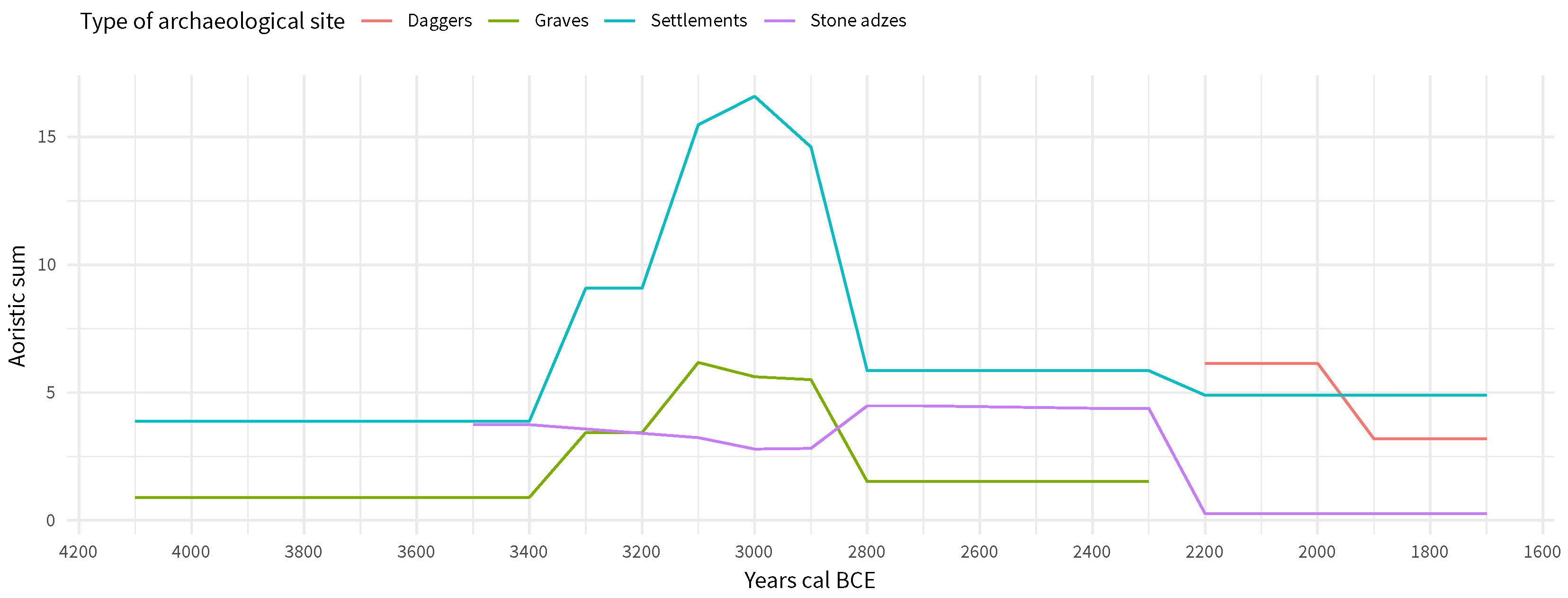
  • The Neolithization process of the earliest Funnel Beaker groups started around 4100 BCE [12], with sporadically practiced arable farming, a mild woodland opening due cattle grazing, the building of nonmegalithic long-mounds [30], and the introduction of new technologies, such as plowing and polished flint adzes.
  • Around 3600 BCE, there was an intensification of crop growing in large arable fields, an increase in the woodland opening [32], and an intensive monument building with megalithic graves [33,34] and enclosures [35,36,37]. The introduction of the ard was an important technological innovation in agriculture [38].
  • Around 3200 BCE, regional demographic growth [10] and a regional to supraregional increase in the number of weapons in burial sites [39] are apparent. A decline in regional ceramic designs, the end of the construction of megaliths, and the introduction of new supraregional pottery designs mark the end of this phase.
  • The appearance of single grave groups [22,40,41] with the first barrows for individual burials, combined with a boom in new monumental activities, marked the development of differently organized societies around 2800 BCE. The increasing Bell Beaker influence [42] around 2400 BCE and the introduction of new methods of flint production signify the transformation to the Late Neolithic period.
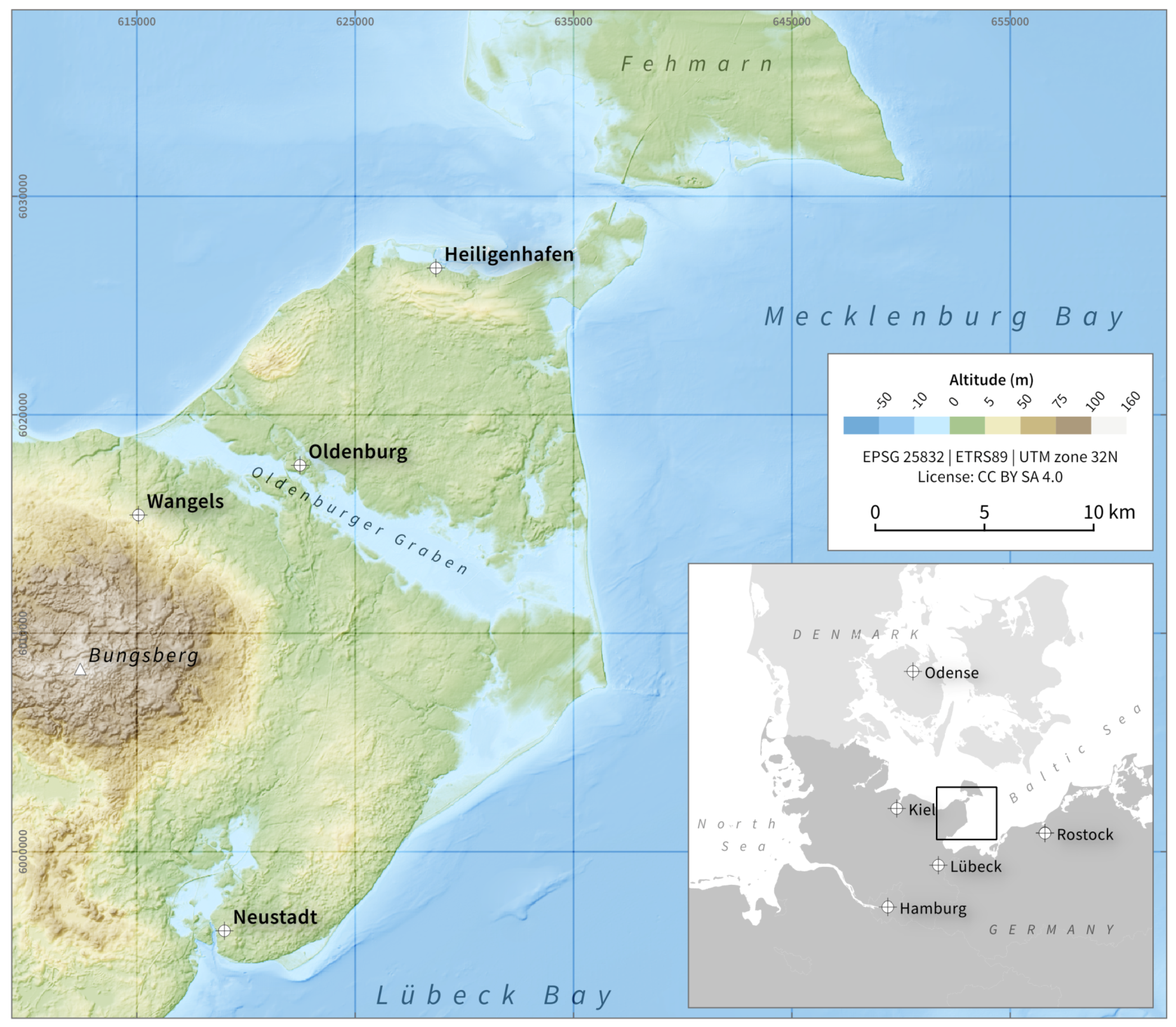
  • Since 2200 BCE, new methods of flint processing appear to dominate in the form of regionally retouched objects, such as flint daggers [23]. Supraregionally, this period displays increasing contact that might be responsible for the start of regional metal production [43].
The complete adaptation to using metal took place in the Bronze Age around 1700 BCE.

1.3. Study Area

The study area of Wagrien is in the western part of Schleswig-Holstein, the northernmost federal state of Germany. The area is part of the Eastern Uplands [44], a region formed by moraines of the Weichselian Glaciation. In general, the area is characterized by a gently rolling ground moraine relief [45]. Sedimentologically, the region is dominated by glacier-induced till deposits, whose initially high carbonate content was decalcinated in postglacial humid climatic conditions; loamification and subsequent decalcination caused the development of Luvisols or, in appropriate locations, stagnic Luvisols [46]. Cambisols are found on more elevated locations and sandy areas. Gleysols, humic Gleysols, and Histosols characterize sandy–loamy depressions [44]. Hence, the area can be considered agriculturally favorable, especially in earlier periods. The modern wetland area of the “Oldenburger Graben” was a shallow firth of the Baltic in the late Atlanticum. Subsequently, rising sea levels increased its surface and led to coastal erosion that blocked the former bay. This led to the development of a brackish lagoon during the Neolithic era. Today, the lowland is characterized by marine, limnic, and telmatic sediments, as well as peats.
The different Neolithic phases considered here took place at a time that was climatically characterized by generally decreasing temperatures [47] and wetter climatic conditions [48]; it was the transition from the Atlantic (ca. 6800–3800 BCE) to the Subboreal period (ca. 3800–700 BCE, [49]). These climate changes had a major impact on the vegetation in the west of Schleswig-Holstein, as reflected by the increasing appearance of shrubs, such as hazel, and decline in the occurrence of tree species, such as elm and lime. From 4100 BCE, anthropogenic indicators increased in dominance, with a steep increase at 3600 BCE (cf. [32]).

2. Methods

Models to reconstruct past societal and socio-environmental transformations are of growing importance for modern integrative archaeological research (e.g., [50,51,52,53,54]). Some common approaches stem from predictive and location modeling (e.g., [55,56,57]). In contrast to these often methodologically advanced studies, we utilized a simple descriptive approach that is less theory-laden and employs as few as possible prior assumptions by focusing on the absolute and relative locations of archaeological sites.

2.1. The Assessment of the Absolute Location of a Site

In order to identify absolute differences in location, we considered the archaeological sites as a point process and employed density analyses (cf. [58,59]). For each Neolithic phase and type of archaeological site, the density—i.e., the intensity function of the point process that generated the point pattern—was calculated [60]. This was done via kernel density estimation using a Gaussian kernel with a size of 2000 m (for further details on the method, see [61]; the threshold was chosen in order to achieve a result that mirrors a smooth density picture; there is no general agreement or rule as to which kernel sizes are appropriate [62]). Subsequently, the differences between the successive phases were calculated. All analyses were conducted using R [63] and the spatstat package [64].

2.2. The Assessment of the Relative Location of a Site

To identify differences in the relative location of archaeological sites, we extracted their topographic locations and took them as indirect indicators of environmental characteristics, since relief characteristics strongly determine soil conditions, water availability, and vegetation characteristics [65]. The different features of topography often show a specific spatial extent and temporal continuity. In simplified terms, we can say that the larger a land-surface form, the longer it has existed (see Figure 3; [66]). Referring to this rule, we are able to employ a modern digital elevation model (DEM) to gain insight into the general characteristics of the topographic location of the archaeological sites. However, more specific information, like the exact distance to water sources or streams, requires geoarchaeological field studies and appropriate dating.
We employed the ropographic position index (TPI), a measure of the relative difference between the elevation of a focused pixel and the mean elevation of its surrounding pixels [67]. It is a measure of the relative topographic location of sites to enable a better understanding of the prominence of the different locations. Positive values indicate exposed locations, while negative values are indicative of valley- or depression-like locations (Figure 4). The analysis was conducted using R [63] and the package raster [68]. We employed a moving window approach with a size of 15 × 15 pixels, i.e., 150 × 150 m. This values—in correspondence with the rule of landforms and existence times (see Figure 3)—allows deriving landforms of sufficient size, so that their general characteristics are comparable to those of the Neolithic.
To investigate the relationship between archaeological sites and rivers, we extracted streams from the DEM. Streams in this context, refer to pixels in which the topographically induced flow exceeds a certain threshold. Accordingly, the number of streams extracted depends on the selected threshold. The flow accumulation, i.e., the number of cells draining through a cell, was calculated on the basis of the multiple flow algorithm [69]. When the flow accumulation exceeds a certain threshold, a stream starts and is traced by the algorithm to its outlet point. The threshold corresponds to the minimum size of the exterior watershed basin in cells [70]: in the present case, the threshold is 3000, which corresponds to 30 ha or roughly 36 football/soccer fields. This threshold was chosen since it corresponds to first-order watersheds in the study area and considers the minimal required size of landforms that in general did not change since the Neolithic era (see Figure 3). The analysis was conducted in GRASS GIS [71] using the r.watershed function.
The values of the two parameters were investigated for the different archaeological sites and the considered Neolithic periods. By comparing the relative frequency of sites on the topographic features, we gained insight into the locational characteristics that are independent of the absolute geospatial location.

3. Results

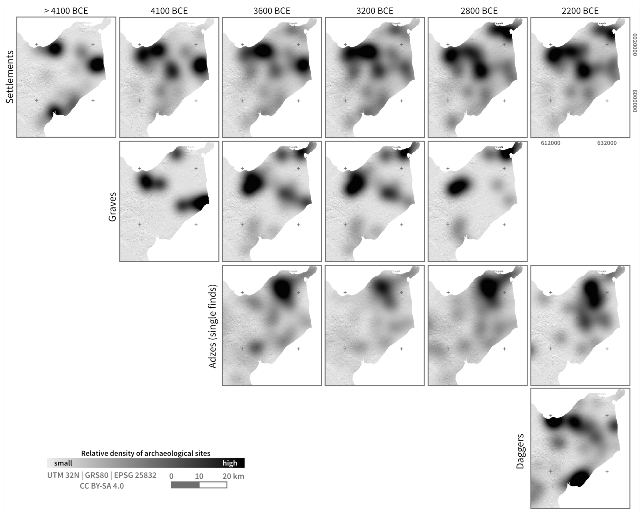
3.1. The Absolute Location of Archaeological Sites

The investigated archaeological sites changed in their absolute locations during the Neolithic phases (Figure 5). In terms of settlements, these dynamics differ between the different phases and highlight specific zones of increased activity in the area (Figure 6).
In the Late Mesolithic period between ca. 5100 and ca. 4100 BCE, three concentrations of settlements can be observed on the Wagric Peninsula: In Western Oldenburger Graben, in Eastern Oldenburger Graben, and in the region of Neustadt in the Lübeck Bay. From the hinterland, however, only a small number of Mesolithic sites are known, so there is an apparent concentration of domestic sites along the firth coast, which was characterized by estuaries. With the beginning of the Neolithic era around 4100 BCE, the regions of the Western and Eastern Oldenburger Graben were less used (Figure 6). However, there was an increase in settlement intensity in the coastal region of the Lübeck Bay and north and south of the Neustadt region. At ca. 3600 BCE, the settlements began to concentrate in Western Oldenburger Graben, and other activities are evident around Neustadt, Bungsberg, Eastern Oldenburger Graben, and in the Heiligenhafen region (Figure 5), although the detectable settlement activity as well as that of the burials decreased at that time (Figure 6). Around 3200 BCE, an increase in domestic sites and burials can be observed. Similarly, a decrease in the number of stone adzes is visible (Figure 6). After ca. 2800 BCE, an expansion of the settlement areas can be observed, and they concentrate mainly in the Oldenburger Graben and the Neustadt Bay. This picture persisted until the end of the Neolithic era and was matched by an increase in stone adzes. Burials became concentrated in the south, adjacent to the Western and Eastern Oldenburger Graben, and in the Heiligenhafen region. Stone adzes concentrated mainly in the northern part of Wagrien, while daggers could be found in Western Oldenburger Graben and in the region around Neustadt (Figure 5).

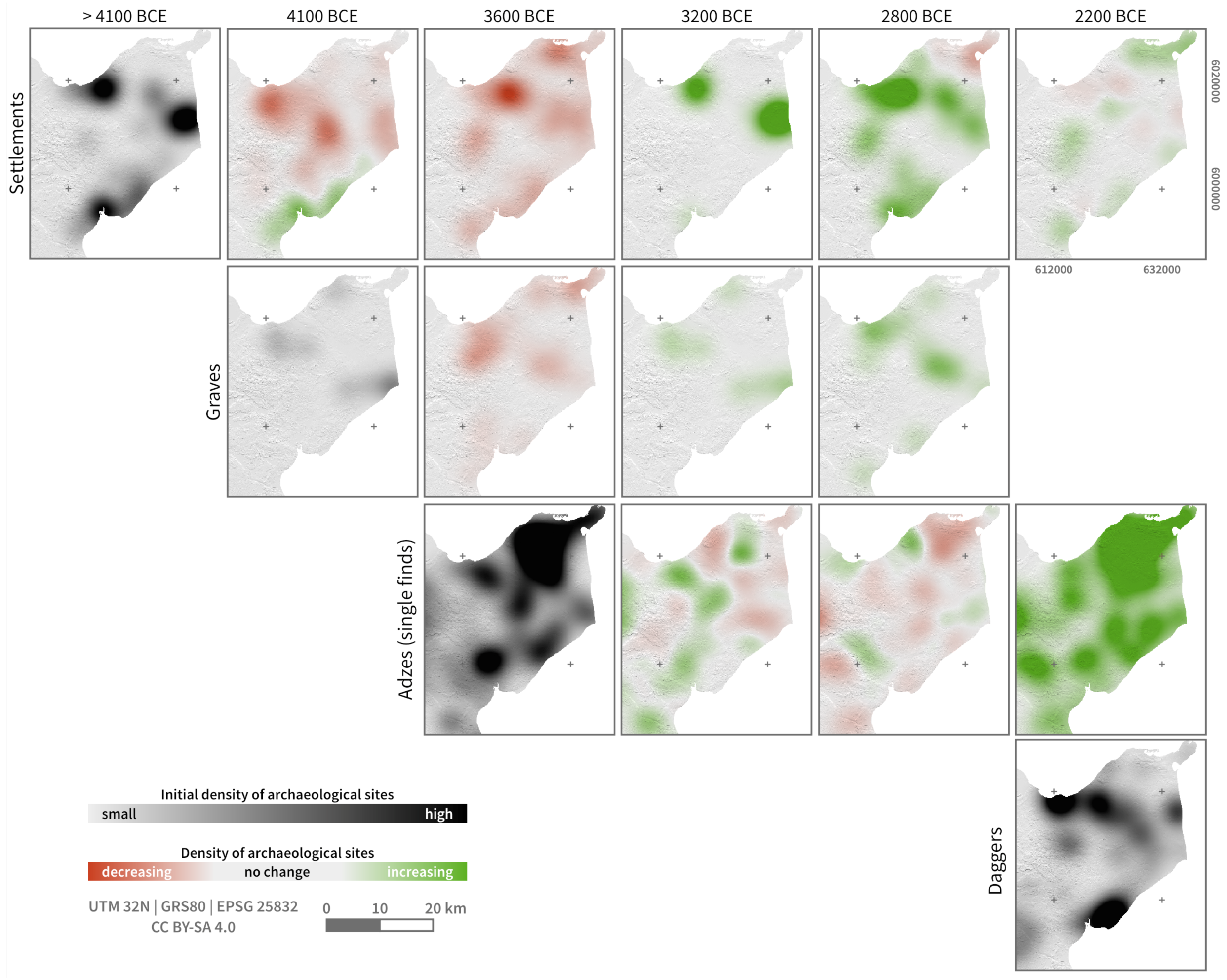
3.2. The Relative Location of Archaeological Sites

The locations of archaeological sites in relation to their topographic position or distance to streams show that settlements had similar location preferences during the Neolithic era, while burials and stone adzes were more heterogeneously distributed. Settlements as well as daggers were located on flat to slightly exposed locations (Figure 7). Stone adzes were located in various but rather sharply defined positions, ranging from more valley-like (negative values of topographic position index) to exposed, hilly locations (positive values of topographic position index, Figure 7). In particular after 3600 BCE, a decrease of the finds in valley-like locations can be discerned, while in the youngest period the finds located at exposed positions diminish. The graves are located in flat to hilly areas with the “Langbetten” covering a larger range than “Steinkammern” (Figure 7). For both grave types, a reduction of the more hilly areas after 4100 BCE can be seen, which becomes more pronounced again in the following times. This variation can also be seen in the distance to streams (Figure 8), especially for the “Langbetten”. In 4100 BCE, the majority was within a radius of 500 m to the streams. In the subsequent periods, they were situated predominantly in the range between 500 and 1000 m with a growing proportion of graves located closer to streams. The stone adzes are rather stable over time with respect to their relative position to streams (Figure 8). They can either be found very close to streams or at about 500 m distance. The peak at 500 m distance is no longer visible in 2200 BCE. The daggers and settlements were located in close vicinity to streams during the Neolithic era (Figure 8).
Compared to the entire study area, where flat areas and short distances to streams are most frequent, archaological findings are located at specific locations of heterogeneous characteristics (Figure 9).

4. Discussion

4.1. Data and Methodological Constraints

The archaeological sample, although large, is still selective; therefore, the interpretations are strictly representative only for the focused study area and employed data. However, as supraregional societal and cultural dynamics appear to have developed comparably, the findings can be, to some extent, generalized.
Methodologically, we employed very simple tools to analyze the relative and absolute location. More complex approaches, including point pattern [72], least-cost modeling [73], fuzzy analyses [74], or viewshed analyses [75], might offer more pronounced insights. However, their drawback is a higher theoretical load, accompanied by more implicit assumptions and, therefore, a loss of generalizability. Our chosen parameters, i.e., the topographic position index and extracted streams, are sensitive to the analyzed scale and need to be adjusted if used in another spatial context.

4.2. Absolute and Relative Location of Archaeological Sites: The Different Scales of Transformation

The investigation of absolute and relative locations of archaeological sites enables us to compare transformation phases and evaluate their individual impact on the localization of settlements and the creation of landscapes.
The final Mesolithic era was characterized by permanently used domestic sites with seasonally visited camps [76,77,78] or groups which moved seasonally between different regions and places (e.g., [79]). An example is the hunting station Neustadt LA 156 [12,80], which was visited seasonally, especially in autumn and winter [12].
In the phase of Neolithization around 4100 BCE, landscape creation activities—as reflected by the active change in the environment by clearance activities with stone adzes—are apparent in the previously only marginally used hinterland of domestic sites. These stone adzes were concentrated in the area of the domestic sites and their vicinity—areas which served to supply the settlement sites. This is quite visible from the differences in relative (Figure 7 and Figure 8) and absolute (Figure 5 and Figure 6) location characteristics. Concerning social organization, it can be assumed that the groups were decentralized and lived as small families on individual farms, surrounded by burial places. This development coincides with small-scale agriculture, mainly in the form of horticulture, whose cultivation areas were in the immediate vicinity of the houses [37]. In addition, specialized hunting stations on islands, in wetlands, and in coastal areas were used to supply the area, enabling access to a wide range of resources [81,82,83,84]. This also includes the enclosures, which, although still undetected in the research area, can be linked to community ritual activities [36] and were possibly included in supraregional transport routes [85].
The increasing construction of megalithic graves in the distribution area of the Funnel Beaker groups—a supraregional phenomenon—and the simultaneous opening of the woodland from ca. 3600 BCE onward indicate population growth [33], which requires a larger area for subsistence but, according to the results, did not lead to a change in the relative location of domestic sites (Figure 7 and Figure 8).
Village-like domestic sites developed for the first time on the Southern Cimbrian peninsula around 3200 BCE in addition to the existing individual farmsteads, such as Büdelsdorf [35] or in Oldenburg-Dannau [10], which were in the immediate vicinity of other settlement sites. Wheels and wagons were subsequently introduced [86]. The burial places, mainly in the form of passage graves with multiple burials at this time, were spatially separated from the settlements in the landscape. The introduction of the ard was an important technological innovation in the already commonly practiced agriculture [38]. Although these new forms of social organization were developing and new technology was emerging, the choice of settlement location—slightly exposed locations in the vicinity of streams—remained unchanged (Figure 7).
The development reached its peak between ca. 3200 and ca. 3000 BCE, when the concentrations of settlement activities in Western and Eastern Oldenburg Graben were highest (Figure 5 and Figure 6). The decline in the settlements in those areas that appeared at a high density beforehand suggests a concentration of individuals in village complexes like Oldenburg-Dannau. Taken together, we observe a continuity of settlement sites and a discontinuity of burial sites in terms of their relative location.
In the Younger Neolithic period, a development toward hamlets [87] and the use of specialized hunting grounds [88] can be assumed. The observation could be related to the increasing use of land for grazing, the possibly dominant economic strategy in the Late Neolithic period. Secondary burials in megalithic tombs used the same ritual sites as in the Middle Neolithic period. The single grave societies, like a northern variant of the European corded ware phenomenon, are at the same time connected with major changes in the social organization, which is expressed by individual burials under burial mounds and a boom in axes as a symbol of a new “warrior ideology”. Around 2200 BCE, extensive single farms were established throughout the research area [89]. Supraregionally, a development of metallurgy exchange systems is also observed [43,90].
Around 2800 BCE, and then from ca. 2200 BCE onward, there was a strong increase in the density of stone adzes (Figure 6), which might indicate increasing economic pressure on the environment. The flint daggers, manufactured mainly from ca. 2200 BCE onward, used new processing techniques and were concentrated on the western coast of Wagrien and in Neustadt Bay. These sites met the same relative site requirements as the settlements (Figure 7 and Figure 8) but were located in other locations in absolute terms (Figure 5). This can be interpreted as possible work sites close to the secondary flint resources. However, this new form of technology did not change the choice of settlement locations, as the work sites fulfilled the same requirements as the settlements.

4.3. The Different Scales of Transformation

The investigation of the relative and absolute locations of archaeological sites shows that spatial dynamics were not directly related to locational preferences. The settlement locations show a persistence in terms of their relative location. This contrasts with the grave monuments that show changing relative locations. Reflecting on the different intentions of the people when they created these landscapes, the observations indicate that transformation had a heterogeneous influence on different societal domains. Graves and mounds, whose role might be mainly attributed to ritual or cultural activities, were constructed at different locations depending on the cultural context. Settlements at which various functions concentrated, ranging from ritual to social to economic, continued to show a preference for similar relative locations. Hence, even very strong transformations that influenced a wide range of societal elements, such as the introduction of the ard or metallurgy, did not change the social practice of establishing settlements at certain preferred locations and, in this regard, ‘producing’ their cultural landscapes. This indicates that different scales, i.e., domains and contexts, of transformation have to be distinguished when the influence of innovations, new techniques, cultural exchanges, or new ritual practices are recognized in the archaeological material. It is also indicative of the complexity of the construction of landscapes; monocausal or simple deterministic explanations are not sufficient to explain where, when, and to what degree societies reacted and reflected upon the changes that have materialized in their material culture and their landscapes. However, it has to be taken into account that other location factors not investigated here, e.g., soil quality, wind protection, visibility, accessibility to specific resources, might have a considerable influence on the choice of locations and their temporal continuity. It is the task of extensive and detailed future field studies and research to clarify this point.

5. Conclusions

In Northern Germany and Southern Scandinavia, as well as in the research area, various Neolithic transformations occurred. These suggest massive socio-cultural changes that are characterized by different strong dynamics of human activity on the environment in different periods. However, as shown in this study, these changes did not have any discernible influence on the locational processes of settlement sites, which is in contrast to the changing locations of ritual sites.
We conclude that domestic sites were chosen according to their ability to meet the basic needs for resource availability and transport routes. Thus, spaces such as wells, bays, and watercourses, where different areas overlapped, might have been especially preferred. The timeline of transformation seems to be mainly associated with the political, social, and ritual sphere of the investigated Neolithic societies, as sites framed by these activities show evidence of changing locations rather than the economically relevant domestic sites. A kind of sustainability with respect to environmental and economic practices might be postulated, although the social agenda is not as stable as previously expected.

Author Contributions

Archaeological data were synthesized by J.P.B. Geographic information and quantitative analyses were conducted by D.K. and W.H. Maps were created by D.K. The text was written by D.K., J.P.B., and W.H. R.D., J.M., and O.N. added comments to the manuscript. D.K., J.P.B., W.H., and J.M. revised the manuscript.

Funding

The research was conducted and financed in the context of the Collaborative Research Centre 1266 “Scales of Transformation—Human-environmental interaction in prehistoric and archaic societies” of the German Research foundation (DFG, German Research Foundation—project number 2901391021—SFB 1266).

Acknowledgments

We thank three anonymous reviewers for their careful reading of our manuscript and their comments and suggestions that improved this paper.

Conflicts of Interest

The authors declare no conflict of interest.

References

  1. Meier, T. ‘Landscape’, ‘Environment’ and a Vision of Interdisciplinarity. In Landscape Archaeology between Art and Science; Kluiving, S.J., Guttmann-Bond, E., Eds.; Amsterdam University Press: Amsterdam, The Netherlands, 2012; pp. 503–514. [Google Scholar]
  2. Billman, B.R.; Feinman, G.M. Settlement Pattern Studies in the Americas: Fifty Years since Virú; Smithsonian Institution Press: Washington, DC, USA, 1999. [Google Scholar]
  3. Bevan, A.; Conolly, J. Multiscalar Approaches to Settlement Pattern Analysis. In Confronting Scale in Archaeology: Issues of Theory and Practice; Lock, G., Molyneaux, B.L., Eds.; Springer: Boston, MA, USA, 2006; pp. 217–234. [Google Scholar]
  4. Eichfeld, I. Die vorrömische Eisenzeit im Landkreis Rotenburg; Isensee, Florian, GmbH: Oldenburg, Germany, 2005. [Google Scholar]
  5. Kantner, J. The Archaeology of Regions: From Discrete Analytical Toolkit to Ubiquitous Spatial Perspective. J. Archaeol. Res. 2008, 16, 37–81. [Google Scholar] [CrossRef]
  6. Parsons, J.R. Archaeological Settlement Patterns. Annu. Rev. Anthropol. 1972, 1, 127–150. [Google Scholar] [CrossRef]
  7. Hartz, S. Die Steinartefakte des endmesolithischen Fundplatzes Grube—Rosenhof: Studien an Flintinventaren aus der Zeit der Neolithisierung in Schleswig-Holstein und Südskandinavien; Wachholtz: Neumünster, Germany, 1999. [Google Scholar]
  8. Meurers-Balke, J. Siggeneben-Süd. Ein Fundplatz der frühen Trichterbecherkultur an der Holsteinischen Ostseeküste; Offa, Wachholtz: Neumünster, Germany, 1983. [Google Scholar]
  9. Hoika, J. Das Mittelneolithikum zur Zeit der Trichterbecherkultur in Nordostholstein. Untersuchungen zu Archäologie und Landschaftsgeschichte; Offa, Wachholtz: Neumünster, Germany, 1987. [Google Scholar]
  10. Brozio, J.P. Megalithanlagen und Siedlungsmuster im Trichterbecherzeitlichen Ostholstein; Frühe Monumentalität und soziale Differenzierung; Habelt: Bonn, Germany, 2016; Volume 9. [Google Scholar]
  11. Jakobsen, O. Die Grube-Wesseker Niederung (Oldenburger Graben, Ostholstein): Quartärgeologische und geoarchäologische Untersuchungen zur Landschaftsgeschichte vor dem Hintergrund des Anhaltenden Postglazialen Meeresspiegelanstiegs. Ph.D. Thesis, Christian-Albrechts-Universität zu Kiel, Kiel, Germany, 2004. [Google Scholar]
  12. Glykou, A. Neustadt LA 156—Ein submariner Fundplatz des späten Mesolithikums und des frühesten Neolithikums in Schleswig-Holstein; Murmann Publishers, Wachholtz: Neumünster, Germany, 2016. [Google Scholar]
  13. Karnatz, J. Die Vorgeschichte des Kreises Ostholstein, der Südteil des Altkreises Oldenburg, die Stein- und Bronzezeit. Ph.D. Thesis, Christian-Albrechts-Universität zu Kiel, Kiel, Germany, 1987. [Google Scholar]
  14. Mennenga, M. Archäoprognose in Schleswig-Holstein. In Wasser, Landschaft und Gesellschaft: Studien zum Ressourcenmanagement der Trichterbechergesellschaft; Müller, J., Ed.; Habelt: Bonn, Germany, 2016; pp. 117–245. [Google Scholar]
  15. Rinne, C. Digitale Archäologie. Nachlass von Jürgen Hoika. Jungsteinsite 2011, 13, 1–6. [Google Scholar]
  16. Breske, B.J. Untersuchungen zu neolithischen Beilen in Schleswig-Holstein. Master’s Thesis, Christian-Albrechts- Universität zu Kiel, Kiel, Germany, 2017. [Google Scholar]
  17. Schwarck, N. Spätneolithische Flintdolche in Ostholstein. Master’s Thesis, Christian-Albrechts-Universität zu Kiel, Kiel, Germany, 2018. [Google Scholar]
  18. Brozio, J.P.; Filipovic, D.; Schmölcke, U.; Kirleis, W.; Müller, J. Mittel- bis Jungneolithische Siedlungshinterlassenschaften zwischen 3300–2600 v. Chr.—Der Fundplatz Oldenburg LA 232 im Oldenburger Graben, Ostholstein. Praehistorische Zeitschrift 2019, 93, 185–224. [Google Scholar] [CrossRef]
  19. Hinz, M.; Furholt, M.; Raetzel-Fabian, D.; Rinne, C.; Sjögren, K.G.; Wotzka, H.P. RADON—Radiocarbon Dates Online 2012. Central European Database of 14C Dates for the Neolithic and Early Bronze Age. Jungsteinsite 2012, 14, 1–4. [Google Scholar]
  20. Brozio, J.P. Zur absoluten Chronologie der Einzelgrabkultur in Norddeutschland und Nordjütland. Germania 2019, in press. [Google Scholar]
  21. Haßmann, H. Die Steinartefakte der Befestigten Neolithischen Siedlung von Büdelsdorf, Kreis Rendsburg- Eckernförde; Universitätsforschungen zur Prähistorischen Archäologie; Habelt: Bonn, Germany, 2000; Volume 62. [Google Scholar]
  22. Hübner, E. Jungneolithische Gräber auf der Jütländischen Halbinsel. Typologische und Chronologische Studien zur Einzelgrabkultur; Volume B 24, Nordiske Fortidsminder; Det Kongelige Nordiske Oldskriftselskab: Køpenhaven, Germany, 2005. [Google Scholar]
  23. Kühn, H.J. Das Spätneolithikum in Schleswig-Holstein; Wachholtz: Neumünster, Germany, 1979. [Google Scholar]
  24. Ratcliffe, J.H. Aoristic Analysis: The Spatial Interpretation of Unspecific Temporal Events. Int. J. Geogr. Inf. Sci. 2000, 14, 669–679. [Google Scholar] [CrossRef]
  25. Ratcliffe, J.H.; McCullagh, M.J. Aoristic Crime Analysis. Int. J. Geogr. Inf. Sci. 1998, 12, 751–764. [Google Scholar] [CrossRef]
  26. Johnson, I. Aoristic Analysis: Seeds of a New Approach to Mapping Archaeological Distributions through Time. In Enter the Past. The E-Way into the Four Dimensions of Cultural Heritage. CAA 2003. Computer Applications and Quantitative Methods in Archaeology (BAR International Series 1227); Fischer-Ausserer, K., Börner, W., Goriany, M., Eds.; Universitätsbibliothek Tübingen: Tübingen, Germany, 2004; pp. 448–452. [Google Scholar]
  27. Mischka, D. Aoristische Analyse in der Archäologie. Archäol. Inf. 2004, 27, 233–243. [Google Scholar]
  28. Brozio, J.P.; Dörfler, W.; Eriksen, B.V.; Grimm, S.; Groß, D.; Hartz, S.; Kirleis, W.; Kneisel, J.; Lübke, H.; Meadows, J.; et al. TransformationsDimensionen—Wildbeuter, Bodenbauer und frühe Metalurgen—Sonderforschungsbereich 1266: Ein neues Großprojekt der Uni Kiel. Archäologische Nachrichten aus Schleswig-Holstein 2017, 22, 18–21. [Google Scholar]
  29. Müller, J.; Peterson, R. Ceramics and Society in Northern Europe. In The Oxford Handbook of Neolithic Europe; Fowler, C., Harding, J., Hofmann, D., Eds.; Oxford University Press: Oxford, UK, 2015; pp. 573–604. [Google Scholar]
  30. Müller, J. Exploring landscapes: The Reconstruction of Social Space: Investigations on Prehistorical and Historical Societies and the Environment = Landschaft Erforschen; Habelt: Bonn, Germany, 2014. [Google Scholar]
  31. Müller, J.; Bork, H.R.; Brozio, J.P.; Demnick, D. Landscapes as social spaces and ritual meaning: Some nen results on TRB in northern germany. In From Funeral Monuments to Household Pottery; Bakker, J.A., Ed.; Archaeopress: Oxford, UK, 2013; Volume 2474, pp. 51–80. [Google Scholar]
  32. Feeser, I.; Dörfler, W.; Averdieck, F.R.; Wiethold, J. New insight into regional and local land-use and vegetation patterns in eastern Schleswig-Holstein during the Neolithic. In Siedlung, Grabenwerk, Großsteingrab; Hinz, M., Müller, J., Eds.; Habelt: Bonn, Germany, 2012; pp. 159–190. [Google Scholar]
  33. Hinz, M.; Feeser, I.; Sjögren, K.G.; Müller, J. Demography and the intensity of cultural activities: an evaluation of Funnel Beaker Societies (4200–2800 cal BC). J. Archaeol. Sci. 2012, 39, 3331–3340. [Google Scholar] [CrossRef]
  34. Fritsch, B.; Furholt, M.; Hinz, M.; Lorenz, L.; Nelson, H.; Schafferer, G.; Schiesberg, S.; Sjögren, K.G. Dichtezentren und lokale Gruppierungen—Eine Karte zu den Großsteingräbern Mittel- und Nordeuropas. J. Neolit. Archaeol. 2010. [Google Scholar] [CrossRef]
  35. Hage, F. Büdelsdorf/Borgstedt: Eine trichterbecherzeitliche Kleinregion; Habelt: Bonn, Germany, 2016. [Google Scholar]
  36. Dibbern, H. Das trichterbecherzeitliche Westholstein: Eine Studie zur Neolithischen Entwicklung von Landschaft und Gesellschaft; Habelt: Bonn, Germany, 2016. [Google Scholar]
  37. Steffens, J. Die neolithischen Fundplätze von Rastorf, Kreis Plön: eine Fallstudie zur Trichterbecherkultur im nördlichen Mitteleuropa am Beispiel eines Siedlungsraumes; Universitätsforschungen zur Prähistorischen Archäologie, Habelt: Bonn, Germany, 2009. [Google Scholar]
  38. Kirleis, W.; Fischer, E. Neolithic cultivation of tetraploid free threshing wheat in Denmark and Northern Germany: Implications for crop diversity and societal dynamics of the Funnel Beaker Culture. Veg. Hist. Archaeobot. 2014, 23, 81–96. [Google Scholar] [CrossRef]
  39. Müller, J. Ritual Cooperation and Ritual Collectivity: The social structure of the middle and younger Funnel beaker North Group (3500–2800 BC). In Megaliths and Identities; Furholt, M., Ed.; Habelt: Bonn, Germany, 2011; pp. 273–284. [Google Scholar]
  40. Struve, K.W. Die Einzelgrabkultur in Schleswig-Holstein und ihre kontinentalen Beziehungen; Wachholtz: Neumünster, Germany, 1955. [Google Scholar]
  41. Schultrich, S. Das Jungneolithikum in Schleswig-Holstein; Sidestone Press: Leiden, The Netherlands, 2018. [Google Scholar]
  42. Mertens, K. Einflüsse der Glockenbecherkultur in Norddeutschland. In The Northeast Frontier of Bell Beakers; Czebreszuk, J., Szmyt, M., Eds.; Archaeopress: Oxford, UK, 2003; pp. 51–71. [Google Scholar]
  43. Vandkilde, H. The Metal Hoard from Pile in Scania, Sweden; The Swedish History Museum, Aarhus Universitetsforlag: Aarhus, Denmark, 2017. [Google Scholar]
  44. Fränzle, O. Reliefentwicklung und Bodenbildung in Schleswig-Holstein. In Streifzug durch 6000 Jahre Landnutzungs- und Landschaftswandel in Schleswig-Holstein: Ein Exkursionsführer; Winkler, G., Dahlke, C., Bork, H.R., Eds.; EcoSys Suppl. Band 41; Verein zur Förderung der Ökosystemforschung: Kiel, Germany, 2004; pp. 11–35. [Google Scholar]
  45. Meynen, E.; Schmithüsen, J. (Eds.) Handbuch der naturräumlichen Gliederung Deutschlands; Bundesanstalt für Landeskunde und Raumforschung: Bad Godesberg, Germany, 1962; Volume Band II. [Google Scholar]
  46. Horn, R.; Fleige, H.; Peth, S. Soils and Landuse Management Systems in Schleswig-Holstein (Germany)—Guide of ISTRO Excursion; Schriftenreihe, Volume 72; Institut für Pflanzenernährung und Bodenkunde: Kiel, Germany, 2006. [Google Scholar]
  47. Böse, M.; Ehlers, J.; Lehmkuhl, F. Holozäne Klima- und Landschaftsgeschichte. In Deutschlands Norden: Vom Erdaltertum zur Gegenwart; Böse, M., Ehlers, J., Lehmkuhl, F., Eds.; Springer: Berlin/Heidelberg, Germany, 2018; pp. 161–194. [Google Scholar]
  48. Barber, K.E.; Chambers, F.M.; Maddy, D. Late Holocene climatic history of northern Germany and Denmark: peat macrofossil investigations at Dosenmoor, Schleswig-Holstein, and Svanemose, Jutland. Boreas 2004, 33, 132–144. [Google Scholar] [CrossRef]
  49. Nelle, O.; Dörfler, W. A summary of the late-and post-glacial vegetation history of Schleswig-Holstein. Mitteilungen der Arbeitsgemeinschaft Geobotanik in Schleswig-Holstein und Hamburg 2008, 65, 45–68. [Google Scholar]
  50. Shennan, S. (Ed.) Pattern and Process in Cultural Evolution; Number 2 in Origins of Human Behavior and Culture; University of California Press: Berkeley, CA, USA, 2009. [Google Scholar]
  51. Zimmermann, A. Cultural Cycles in Central Europe during the Holocene. Quat. Int. 2012, 274, 251–258. [Google Scholar] [CrossRef]
  52. Gronenborn, D.; Strien, H.C.; Dietrich, S.; Sirocko, F. ‘Adaptive Cycles’ and Climate Fluctuations: A Case Study from Linear Pottery Culture in Western Central Europe. J. Archaeol. Sci. 2014, 51, 73–83. [Google Scholar] [CrossRef]
  53. Nakoinz, O. Fingerprinting Iron Age Communities in South-West Germany and an Integrative Theory of Culture. In Fingerprintig the Iron Age; Popa, C.N., Stoddart, S., Eds.; Oxbow Books: Oxford, UK, 2014; pp. 187–199. [Google Scholar]
  54. Nakoinz, O.; Hinz, M. Modelle in der Archäologie. In Wissenschaft und Kunst der Modellierung Kieler Zugang zur Definition, Nutzung und Zukunft; Thalheim, B., Nissen, I., Eds.; De Gruyter: Berlin, Germany; Boston, MA, USA, 2015; pp. 119–249. [Google Scholar]
  55. Kamermans, H. Predictive Maps and Land Quality Mapping. In Symposium: The Archaeology of Landscape and Geographic Information Systems—Predictive Maps, Settlement Dynamics and Space and Territory in Prehistory; Brandenburgisches Landesamt für Denkmalpflege und Archäologisches Landesmuseum: Brandenburg, Germany, 2003; pp. 151–160. [Google Scholar]
  56. Verhagen, P. Case Studies in Archaeological Predictive Modelling; Leiden University Press: Leiden, The Netherlands, 2007. [Google Scholar]
  57. Cet, M.D. Long-Term Social Development on a Mediterranean Island: Menorca between 1600 BCE and 1900 CE; Habelt: Bonn, Germany, 2017. [Google Scholar]
  58. Nakoinz, O.; Knitter, D. Modelling Human Behaviour in Landscapes; Springer International Publishing: Cham, Switzerland, 2016. [Google Scholar]
  59. Lloyd, C.D. Spatial Data Analysis: An Introduction for GIS Users; Oxford University Press: Oxford, UK; New York, NY, USA, 2010. [Google Scholar]
  60. Baddeley, A.; Rubak, E.; Turner, R. Spatial Point Patterns: Methodology and Applications with R; Champan & Hall/CRC Interdisciplinary Statistics Series; CRC Press, Taylor & Francis Group: Boca Raton, FL, USA, 2016. [Google Scholar]
  61. Knitter, D.; Nakoinz, O. Point Pattern Analysis as Tool for Digital Geoarchaeology: A Case Study of Megalithic Graves in Schleswig-Holstein, Germany. In Digital Geoarchaeology; Siart, C., Forbriger, M., Bubenzer, O., Eds.; Natural Science in Archaeology; Springer: Cham, Switzerland, 2018; pp. 45–64. [Google Scholar]
  62. Bivand, R.S.; Pebesma, E.; Gomez-Rubio, V. Applied Spatial Data Analysis with R; Springer: New York, NY, USA, 2013. [Google Scholar]
  63. R Core Team. R: A Language and Environment for Statistical Computing; R Foundation for Statistical Computing: Vienna, Austria, 2017. [Google Scholar]
  64. Baddeley, A.; Turner, R. Spatstat: An R package for analyzing spatial point patterns. J. Stat. Softw. 2005, 12, 1–42. [Google Scholar] [CrossRef]
  65. Huggett, R. Fundamentals of Geomorphology; Routledge: Oxon, UK, 2007. [Google Scholar]
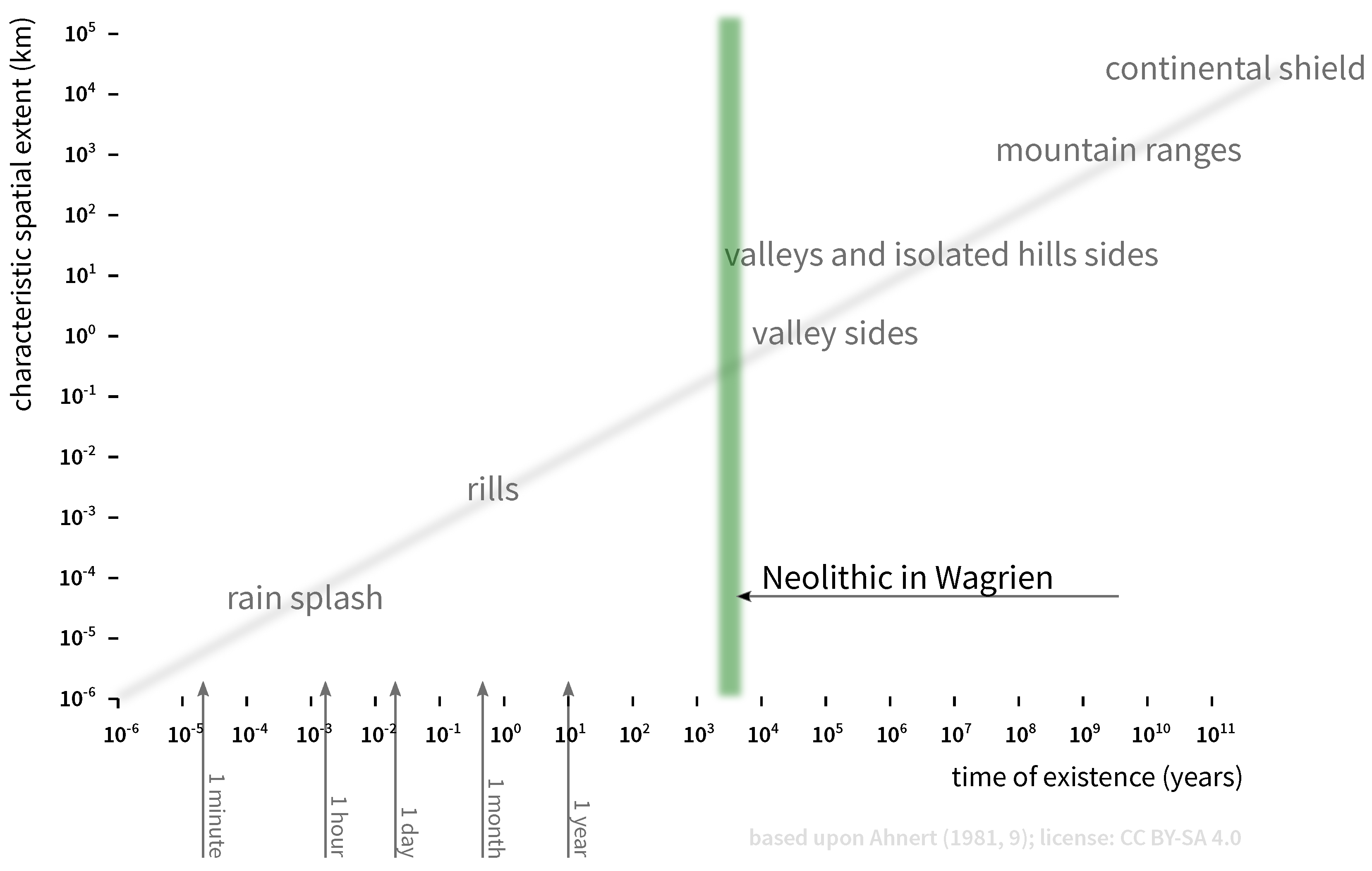
  66. Ahnert, F. Über die Beziehung zwischen quantitativen, semiquantitativen und qualitativen Methoden in der Geomorphologie. Zeitschrift für Geomorphologie NF Suppl. Band 1981, 39, 1–28. [Google Scholar]
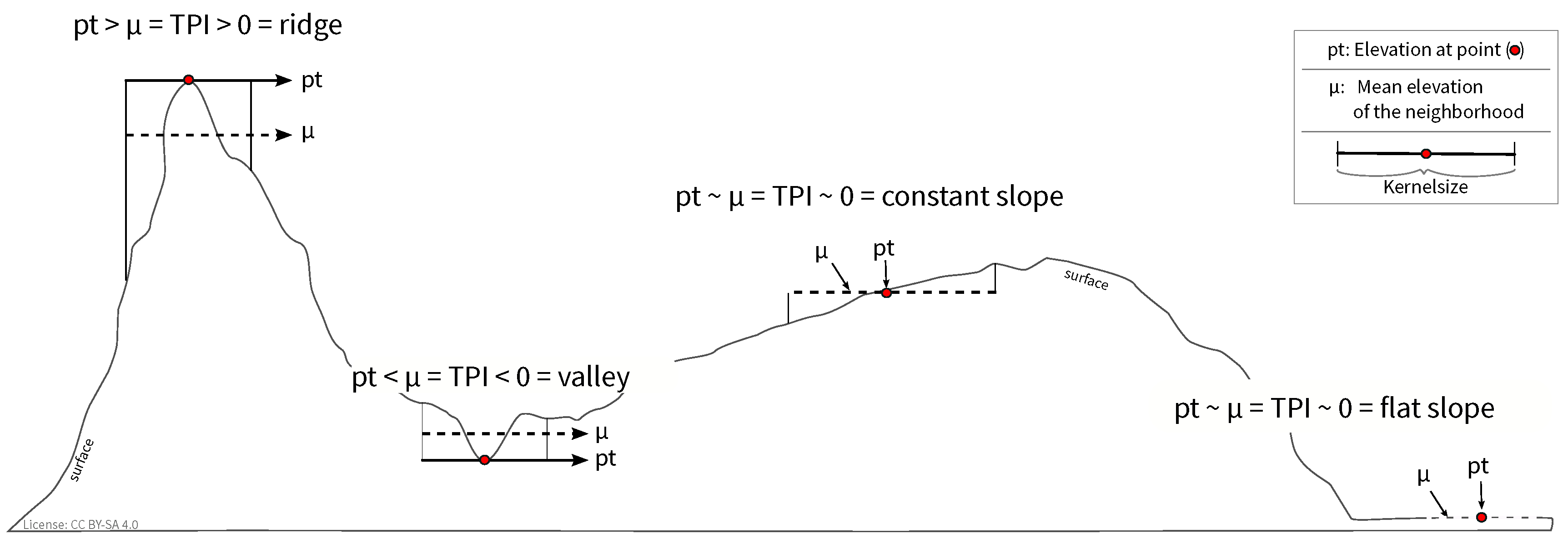
  67. Weiss, A. Topographic position and landforms analysis. In Proceedings of the Poster Presentation at the ESRI User Conference, San Diego, CA, USA, 9–13 July 2001. [Google Scholar]
  68. Hijmans, R.J. raster: Geographic Data Analysis and Modeling. Available online: https://CRAN.R-project.org/package=raster (accessed on 1 February 2019).
  69. Holmgren, P. Multiple flow direction algorithms for runoff modelling in grid based elevation models: An empirical evaluation. Hydrol. Process. 1994, 8, 327–334. [Google Scholar] [CrossRef]
  70. Neteler, M. Open Source GIS: A GRASS GIS Approach; Springer: New York, NY, USA, 2007. [Google Scholar]
  71. GRASS Development Team. Geographic Resources Analysis Support System (GRASS GIS) Software, Version 7.2; GRASS GIS: Champaign, IL, USA, 2017. [Google Scholar]
  72. Meister, J.; Knitter, D.; Krause, J.; Müller-Neuhof, B.; Schütt, B. A Pastoral Landscape for Millennia: Investigating Pastoral Mobility in Northeastern Jordan Using Quantitative Spatial Analyses. Quat. Int. 2019, 501, 364–378. [Google Scholar] [CrossRef]
  73. Groenhuijzen, M.R.; Verhagen, P. Exploring the dynamics of transport in the Dutch limes. eTopoi J. Anc. Stud. 2015, Special Volume 4, 25–47. [Google Scholar]
  74. Popa, C.N.; Knitter, D. From Environment to Landscape. Reconstructing Environment Perception Using Numerical Data. J. Archaeol. Method Theory 2015, 23, 1285–1306. [Google Scholar] [CrossRef] [PubMed]
  75. Gillings, M. Visual Affordance, Landscape, and the Megaliths of Alderney. Oxf. J. Archaeol. 2009, 28, 335–356. [Google Scholar] [CrossRef]
  76. Zvelebil, M. Innovating hunter-gatherers: The Mesolithic in the Baltic. In Mesolithic Europe; Bailey, G.N., Spikins, P., Eds.; Cambridge University Press: Cambridge, UK, 2008; pp. 18–59. [Google Scholar]
  77. Rowley-Conwy, P. Season and Reason: the case for a regional interpretation of mesolithic settlement patterns. In Hunting and Animal Exploitation in the Later Palaeolithic and Mesolithic of Eurasia; Peterkin, G.L., Bergman, C.A., Eds.; American Anthropological Assoc.: Washington, DC, USA, 1993; pp. 179–188. [Google Scholar]
  78. Grøn, O. Mesolithic dwelling places in south Scandinavia: Their definition and social interpretation. Antiquity 2003, 77, 685–708. [Google Scholar] [CrossRef]
  79. Johansen, K.L. Settlement and land use at the Mesolithic-Neolithic transition in Southern Scandinavia. J. Dan. Arch. 2006, 14, 201–223. [Google Scholar] [CrossRef]
  80. Whitehouse, N.J.; Schulting, R.J.; McClatchie, M.; Barratt, P.; McLaughlin, T.R.; Bogaard, A.; Colledge, S.; Marchant, R.; Gaffrey, J.; Bunting, M.J. Neolithic agriculture on the European western frontier: The boom and bust of early farming in Ireland. J. Archaeol. Sci. 2014, 51, 181–205. [Google Scholar] [CrossRef]
  81. Skaarup, J. Hesselø–Sølager. Jagdstationen der Südskandinavischen Trichterbecherkultur; Ark. Studier., Akademisk Forlag: Køpenhaven, Denmark, 1973. [Google Scholar]
  82. Madsen, T. Settlement Systems of early Agriculture Societies in East Jutland, Denmark. A regional Study of Change. J. Anthropol. Archaeol. 1982, 1, 197–236. [Google Scholar] [CrossRef]
  83. Madsen, C.; Thrane, H. Sydvestfynske dysser og yngre stenalders bebyggelse. In Fynske Minder; Odense Bys Museer: Odense, Denmark, 1982; pp. 17–42. [Google Scholar]
  84. Johansson, L. Bistoft LA 11: Siedlungs und Wirtschaftsformen im frühen Neolithikum Norddeutschlands und Südskandinaviens. Offa 1981, 38, 91–129. [Google Scholar]
  85. Klassen, L. Along the Road: Aspects of Causewayed Enclosures in South Scandinavia & Beyond; East Jutland Museum Publications Series; Aarhus University Press: Aarhus, Denmark, 2014. [Google Scholar]
  86. Mischka, D. Das Neolithikum in Flintbek, Kr. Rendsburg-Eckernförde, Schleswig-Holstein: Eine feinchronologische Studie zur Besiedlungsgeschichte einer Siedlungskammer anhand von Gräbern; Habilitationsschrift, Christian-Albrechts-Universität zu Kiel: Kiel, Germany, 2011. [Google Scholar]
  87. Harten, L.; Klooß, S.; Nakoinz, O. Neolithische Spuren unterm Weihnachtsbaum—Der Fundplatz Stolpe/-Depenau, Kreis Plön, LA 17. Archäologische Nachrichten aus Schleswig-Holstein 2011, 17, 58–61. [Google Scholar]
  88. Becker, D.; Benecke, N. Die neolithische Inselsiedlung am Löddigsee bei Parchim: Archäologische und archäozoologische Untersuchungen; Volume 40, Beiträge zur Ur- und Frühgeschichte Mecklenburg-Vorpommerns; Archäologisches Landesmuseum Mecklenburg-Vorpommern: Lübstorf, Germany, 2002. [Google Scholar]
  89. Zich, B. Das spätneolithische Haus Flintbek LA 20 und nord- und mitteleuropäische Entsprechungen. In Vom Pfostenloch zum Steinzeithaus. Archäologische Forschungen und Rekonstruktion jungsteinzeitlicher Haus- und Siedlungsbefunde im nordwestlichen Mitteleuropa; Kelm, R., Ed.; Boyens & Co.: Heide, Germany, 2000; pp. 88–100. [Google Scholar]
  90. Klassen, L. Jade und Kupfer: Untersuchungen zum Neolithisierungsprozess im Westlichen Ostseeraum unter besonderer Berücksichtigung der Kulturentwicklung Europas 5500–3500 BC; Aarhus University Press: Aarhus, Denmark, 2004. [Google Scholar]
Figure 1. The location of the study area with sites mentioned in the text.
Land 08 00068 g001
Figure 2. Diagram of the aoristic densities of settlements, burials, and depositions between 4100–1700 BCE in Wagrien (see also Table 1).
Land 08 00068 g002
Figure 3. Rule of spatial extent versus duration of existence of selected landforms. The green bar indicates the Neolithic era in Wagrien. It becomes obvious that valleys and larger landforms have apparently existed for a longer period of time than the focus period. Accordingly, it is appropriate to utilize a modern digital elevation model to gain insight into the general structure and character of the topography.
Land 08 00068 g003
Figure 4. Principle of topographic position index (TPI). Positive TPI values are indicative of ridges or hilltops, while negative values are representative of valleys. TPI values around 0 correspond to plains or straight slopes. Landforms are sensitive to scale. Accordingly, the size of the kernel determines which topographic features are recognizable.
Land 08 00068 g004
Figure 5. Absolute location differences as reflected by density differences in archaeological sites during Neolithic transformation phases (Rows indicate the different archaeological sources and context; columns correspond to the different Neolithic phases, whose starting dates are shown. The utilized archaeological sample corresponds to all finds that belong to the different phases.).
Land 08 00068 g005
Figure 6. Differences in the absolute location of archaological sites throughout transformation periods (Rows indicate the different archaeological sources and context; columns correspond to the different Neolithic phases whose starting dates are shown. The utilized archaeological sample corresponds to all finds that belong to the different phases.).
Land 08 00068 g006
Figure 7. The occurrence of archaeological sites in relation to topographic location during Neolithic phases. Settlement characteristics did not change during the Neolithic era and showed a preference for flat locations. Graves and stone adzes had a more heterogeneous pattern of distribution, with a focus on flat and slightly exposed locations.
Land 08 00068 g007
Figure 8. The occurrence of archaeological sites in relation to their distance to streams during Neolithic phases. Graves and stone adzes changed in their location preferences, while settlements generally tended toward localizing at short distances from streams.
Land 08 00068 g008
Figure 9. Relative location characteristics of the study area (gray shaded area) and the employed archaeological sites (colored lines). It becomes obvious that the characteristics of the individual types of archaeological sites differ with respect to the other types and to the study area characteristics.
Land 08 00068 g009
Table 1. Neolithic chronology in Wagrien. Main transformations (gray shaded) took place between FM and ENIa; ENIb and ENII; MNI and MNII; MNV and YN1; YN3 and LNII.
Archaeological CultureNamePeriodcalBCE
ErtebølleFinal MesolithicFM5300–4100
Funnel Beaker CultureEarly NeolithicEN Ia4100–3800
EN Ib3800–3500
EN II3500–3300
Middle NeolithicMN Ia3300–3200
MN Ib3200–3100
MN II3100–3000
MN III/IV3000–2900
MN V2900–2800
Single Grave CultureYounger NeolithicYN 12800–2600
YN 22600–2400
YN 32400–2200
Dagger GroupsLate NeolithicLN I2200–1900
LN II1900–1700
For the aoristic analysis and modeling, a standardization of the interval of the archaeological periods was applied in individual cases. This concerns, in particular, the periods MN V to LN II, in which temporal phenomena occur which are also affected by standard deviations in the dating of archaeological data.

