Article

The Role of Citizen Science in Landscape and Seascape Approaches to Integrating Conservation and Development

1
Centre for Tropical Environmental and Sustainability Science, College of Marine and Environmental Sciences, James Cook University, P.O. Box 6811, Cairns, QLD 4870, Australia
2
Research Centre for Climate Change, University of Indonesia, Kampus UI Depok, West Java 16424, Indonesia
3
Kuranda Envirocare, Kuranda, QLD 4881, Australia
4
The Cairns Institute, James Cook University, P.O. Box 6811, Cairns, QLD 4870, Australia
5
The Fenner School of Environment and Society, Australian National University, Linnaeus Way, Canberra, ACT 2601, Australia
*
Author to whom correspondence should be addressed.
Land 2015, 4(4), 1200-1212; https://doi.org/10.3390/land4041200
Submission received: 7 October 2015 / Revised: 22 November 2015 / Accepted: 3 December 2015 / Published: 9 December 2015

Abstract

:
Initiatives to manage landscapes for both biodiversity protection and sustainable development commonly employ participatory methods to exploit the knowledge of citizens. We review five examples of citizen groups engaging with landscape scale conservation initiatives to contribute their knowledge, collect data for monitoring programs, study systems to detect patterns, and test hypotheses on aspects of landscape dynamics. Three are from landscape interventions that deliberately target biodiversity conservation and aim to have sustainable development as a collateral outcome. The other two are driven primarily by concerns for agricultural sustainability with biodiversity conservation as a collateral outcome. All five include programs in which, management agencies support data collection by citizen groups to monitor landscape changes. Situations where citizen groups self-organise to collect data and interpret data to aid in landscape scale decision making are less common and are restricted to landscapes where the inhabitants have a high level of scientific literacy. Given the complexity of landscape processes and the multiple decision makers who influence landscape outcomes we argue that citizen science broadly defined should be an essential element of landscape scale initiatives. Conservation managers should create space for citizen engagement in science and should empower citizen groups to experiment, learn, and adapt their decision-making to improve landscape scale outcomes.

Graphical Abstract

1. Introduction

Land and seascapes are emerging as an organising framework for reconciling biodiversity conservation with other competing land uses [1]. Landscape approaches are used to achieve spatial integration of production and conservation in land cover mosaics [2,3]. Some landscape configurations contribute more than others to the resilience of both human livelihoods and biodiverse natural systems in the face of threats such as climate change [4]. However, landscape outcomes do not emerge as a product of grand design but are determined by an array of individual decisions of numerous diverse and often conflicted stakeholders influenced by regulations, incentives and social pressures. This process has been characterised as muddling through [5,6]. Sectoral institutions and spatial planning are often inadequate in mediating these ongoing transitions and landscape outcomes generally emerge as a response to numerous conflicting drivers of change [7].
There are a number of different ways in which citizen science [8,9] can contribute to conservation at landscape scales. On the simplest level, it is common for amateur scientists or people from local communities to contribute to databases on the flora and fauna of particular areas. Interested volunteers record the presence or abundance of species in different habitats or under different conditions [10]. Bird counts are a common example of this [11]. Scientists may then interpret the data to add value to studies they are undertaking. This is citizen participation but not citizen-driven science. A deeper involvement can come through local people contributing knowledge and/or experience to the design of a study and the interpretation of results [12]. For example, the traditional knowledge of indigenous people may be used by scientists to erect hypotheses. Similarly, knowledge acquired by farmers over generations may help scientists to develop hypotheses and interpret results. This kind of involvement can extend further to a group of concerned citizens erecting their own hypotheses and pursuing the scientific process of collecting data and testing those hypotheses, either with or without the support of professional scientists. This is, perhaps, the ideal to which citizen science could aspire, but in reality there is probably a continuum from the simplest case of using local knowledge, observation and recording data through to the ideal of a totally citizen-driven process with varying levels of involvement and co-development of knowledge in between.
The involvement of citizens across this entire continuum will surely be needed to achieve landscapes that balance conservation and development. The participating citizens are the people who experience the consequences of landscape change and in turn determine through their actions the evolution of the landscape. Lasting change will depend on the decisions they make and cannot be affected without them. Landscape approaches need to embrace the potential of citizen science more fully as a fundamental way of achieving the social learning that should be an essential driver of landscape change.

2. Case Studies

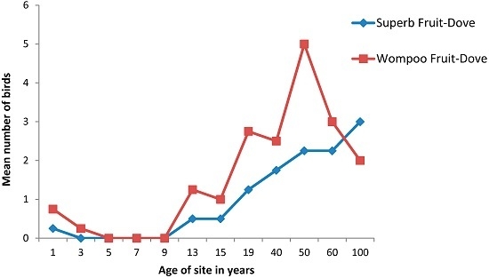
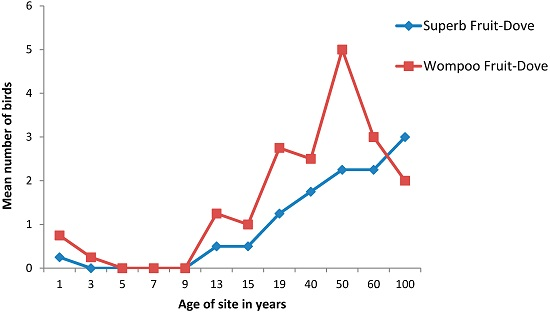
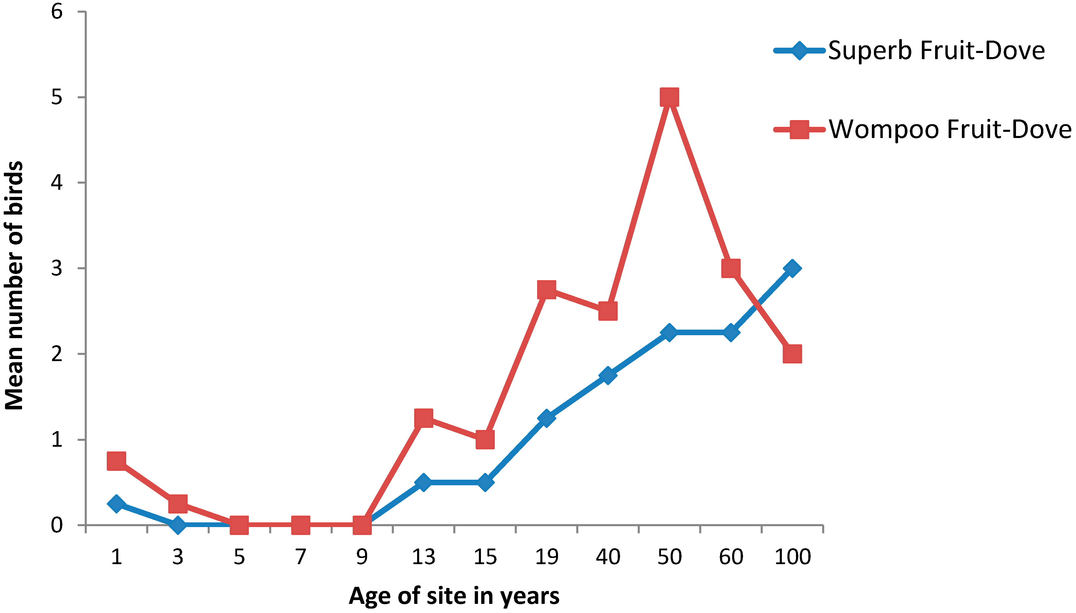
2.1. The Wet Tropics of Australia

The Wet Tropics region of Australia extends 500 km along the north Queensland coast between Townsville and Cooktown, forming a belt approximately 50 km wide. Although less than 1% of the State of Queensland in area and having a population of around 200,000 people , the region contains the highest biological diversity in Australia and is recognised as one of the world’s mega-diverse regions [13]. As well as outstanding natural values it has significant tourism and other economic values [14]. A little less than half of the entire 2.2 million hectare Wet Tropics region was granted World Heritage status in 1988. The forests of the wet tropics border the Great Barrier Reef, providing a unique example of two World Heritage Areas interacting [15].
When this World Heritage area was established, conservation and production were treated as mutually exclusive activities [16]. The original perception was that conservation would take place in the World Heritage area under the management of the Wet Tropics Management Authority. Primary production and urban expansion were to happen elsewhere. This segregated view of the landscape is gradually changing [17]. There is increasing recognition that proactive management for multiple uses and values across boundaries is needed to address conservation and development challenges. The influence of land-based activities in the Wet Tropics on the adjacent Great Barrier Reef is also becoming a stronger focus of attention.
During the past decade, landscape approaches have emerged in Australia as the predominant paradigm for management of complex World Heritage areas such as the Wet Tropics [18]. In addition to the formal regulatory Wet Tropics Management Authority, a community-based regional natural resource management framework, has been established, led by a parastatal body called Terrain NRM (www.terrain.org.au). Regional natural resources plans have explicitly integrated the concept of citizen science. An interface between science providers and community stakeholders has been used in the development and review of regional catchment-scale natural resource plans [19]. Several scientific papers have been jointly published by scientists and local people with knowledge of natural resource management issues [20]. Explicit investments have been made, for example, in involving citizen scientists in monitoring revegetation success, trends in the abundance of the spectacled flying fox Pteropus conspicillatus, the location of Cassowary, Casuarius casuarius, sightings, water quality, etc., to underpin management interventions.
Since the early 1990s a local non-governmental organisation, Kuranda Envirocare, (Kuranda.envirocare.org.au) has been restoring rainforest corridors in areas that have been colonised by exotic grasses to link habitat fragments and provide habitat continuity for rainforest biota. During 2013 volunteers undertook a series of bird surveys in restored forests of different ages. The surveys showed that most species of rainforest-dependent birds began to use newly planted stands within 10 years of establishment and many species occupied reforested areas from year one. Counts of two species of fruit-dove, the Brown Cuckoo-dove, Macropygia amboinensis and Emerald dove, Chalcophaps indica peaked in five year old stands when their favoured fruit bearing trees Alphitonia petriei and Homolanthus novoguineensis began fruiting. Two other fruit-doves, the Superb fruit-dove, Ptilinopus superbus and Wompoo fruit-dove, P. magnificus were much later in arriving (Figure 1) as their preferred fruits, laurels (Lauraceae), figs (Moraceae), and quandongs (Elaeocarpus spp.) only matured in older stands.
Figure 1. Average counts (n = 4) of two species of fruit-doves in different aged planted sites up to 19 years old and older reference sites, Barron River. Unpublished data from Kuranda Envirocare.
Land 04 01200 g001
Knowledge of trends in colonisation by some 30 rainforest bird species is now being used to establish hypotheses for testing in more recently planted rainforest stands where more intensive bird and habitat monitoring has been established. These studies determine the ages at which sites are being used for nesting and seasonal feeding and will elucidate the roles of remnant vegetation. While these studies are citizen-led they have received methodological support from university scientists and funding from the non-governmental organisation, BirdLife Australia.
In addition to the above, citizen-led research is contributing to the delivery of the Reef Water Quality Protection Plan [16,21,22,23,24], while other projects have focused on the identification of linked biophysical and cultural indicators [25] and mapping the health of cultural ecosystem services [26].
Positive environmental and social outcomes from these research activities have been reported [20,23,27,28]; a major finding has been that citizen engagement is critical for social learning and has changed behaviour of individual land managers within the landscape. Many citizens now actively value the biodiversity on their properties and actively manage their own land for wildlife. Citizens frequently mobilise to counter any threats to nature and property values are enhanced by the presence of rain forest species.

2.2. The Lake Eyre Basin of Central Australia

Lake Eyre is an ephemeral salt lake at the centre of an internally draining basin that covers more than 1.2 million square km in central Australia [29]. The Lake Eyre Basin is inhabited by fewer than 60,000 people. It cuts across multiple political and administrative jurisdictions including Queensland, South Australia and the Northern Territory. It is a unique desert river system with unregulated ephemeral rivers, permanent waterholes and artesian springs. The Basin’s diverse landscapes range from sandy and stony deserts to rolling grasslands. The region contains many significant indigenous heritage sites. Land use is dominated by pastoralism, nature conservation, mining, and petroleum extraction [30].
In the late 1990’s two complementary management processes were initiated—one a community-led initiative across jurisdictional borders and the other a joint government process between the Federal Government and States. The community initiative was based upon an iterative process that enabled co-learning and dialogue between different stakeholders including community members, indigenous people and scientists.
A proposal for cotton farming on the Cooper Creek, upstream of Lake Eyre in Queensland further encouraged parties to work together; in this case to challenge this potentially damaging impact on ecological and pastoral values in the catchment. Collaboration between pastoralists, scientists, traditional owners, and community members grew out of a community science workshop in 1995. Eventually the cotton proposal was defeated and citizen-led research gained credibility across the basin. In one instance a local pastoralist has become an internationally recognised citizen scientist himself, discovering a range of new species and contributing significant ecological insights (http://www.abc.net.au/radionational/programs/offtrack/angus-emmott/4648754, accessed on 17 February 2015).
The informal community and scientific collaborations described above led to the establishment of the Lake Eyre Basin Intergovernmental Agreement supported by both a Community Advisory Committee and a Scientific Advisory Panel. These bodies determine priorities, share knowledge, and advise a ministerial forum. An Intergovernmental Agreement came into effect in 2001 to provide for the sustainable management of the Lake Eyre Basin. The Agreement states: “that the collective local knowledge and experience of the Lake Eyre Basin Agreement Area communities are of significant value; and that decisions need to be based on the best available scientific and technical information together with the collective local knowledge and experience of communities within the Lake Eyre Basin Agreement Area.” In accordance with these principles the committees and Ministers agreed upon and instituted a Strategic Adaptive Management process for the Basin which recognises the role of citizens in monitoring, research, and land management (http://www.lakeeyrebasin.gov.au/resources/publications, accessed on 26 February 2015).
The Lake Eyre Basin experience represents one step further along the continuum of citizen engagement with the capacity of citizens to contribute important scientific information being formally recognised in government-led processes. Citizens and scientists are co-learning to better understand the ecological and social processes that are shaping the landscape.

2.3. The Sangha Tri-National Landscape in the Congo Basin

The Sangha Tri-National landscape covers an area of 43,000 km2 across the borders of Cameroon, the Central African Republic, and the Republic of Congo and has a population of 200,000 people. It is one of 12 landscapes identified as conservation priorities under the Congo Basin Forest Partnership adopted at the World Summit on Environment and Development in Durban in 2002 (http://www.cbfp.org, accessed on 20 December 2014). Several international conservation organisations are active in the landscape and all aspire to achieve improved livelihoods for local people and to conserve the rich biodiversity of the forests. In 2002 a process was initiated to engage local stakeholders in the scientific monitoring of changes in the environment and in local livelihoods [31]. A range of participatory tools were used to enable local people to identify future landscape scenarios that they believed would meet their livelihood needs and conserve biodiversity [32]. Indicators for both environmental and local livelihood values were identified by the different stakeholders in the landscape—these indicators allowed progress towards achieving the desired landscapes to be monitored. The indicators were assessed annually by local people and multi-stakeholder fora were held to discuss progress and assess the ways in which conservation and development interventions and external factors had impacted on landscape change [31].
Aid donors active in the landscape were strongly committed to small local interventions to improve agriculture, introduce new crops and livestock, and provide simple new agricultural technologies. It soon emerged that adoption rates for these micro-interventions were low but that macro-economic changes and large scale investments had far higher impacts on local livelihoods and the environment [33,34]. Development initiatives such as mining, sawmills and, potentially, palm oil plantations, were recognised by local citizens as the real drivers of change in the landscape. External investments brought jobs and social infrastructure and concentrated people in development poles, thus reducing human pressure on the remote hinterlands. Biodiversity values would be maintained in protected areas in these hinterlands.
The citizens engaged in this science compiled data and accumulated evidence that supported the case that micro-interventions were less effective in achieving conservation and development outcomes than larger scale initiatives [31,34,35]. The stakeholder forum included both local citizens of both local Bantu groups and the Baka Pygmies who inhabit the forests, together with representatives of the aid agencies and conservation organisations active in the landscape. The results of the monitoring of indicators and the debates at the stakeholder forums were communicated to higher level decision-makers. Evidence for the ineffectiveness of micro-level interventions and the potential benefits of larger scale investments ran counter to the orthodoxy of the external agencies funding the programmes. These agencies appeared to be rooted in a political economy that saw all external commercial investment as a threat to biodiversity and to the traditional livelihoods of forest dependent people. The rhetoric of the external conservation groups was about linking conservation with development but their actions tended to support the status quo. Citizen science has challenged these assumptions although it remains to be seen if this will result in significant policy changes.
The Sangha Tri-National example illustrates the potential weakness of a citizen science approach to social learning in a landscape. Citizen science can test hypotheses and build consensus amongst important groups of stakeholders but if it fails to gain traction amongst higher level decision-makers it will not succeed. Citizen science should ideally engage with all decision makers but if this is not possible it should at least be rooted in strategies for communicating with and influencing those in positions of power.

2.4. The Bird’s Head Seascape, Indonesian Papua

The Bird’s Head Seascape is located in eastern Indonesia, encompassing the waters and islands, and some of the coastal areas, of Papua Barat province on the Indonesian side of the island of New Guinea. Bird’s Head refers to the shape of New Guinea Island at this, its western end. Over 40% of the 761,000 people living in the seascape fall below the poverty line [36] and the landscape has one of the highest poverty rates in Indonesia. Since the early 1960s the Indonesian government has implemented transmigration programs to encourage families from overpopulated islands further west, to settle in West Papua, which is on the brink of experiencing accelerated economic growth based on its vast natural resource wealth. Today the seascape remains one of the few parts of Indonesia yet to experience major development.
The Birds Head Seascape is the global epicentre of tropical shallow water marine biodiversity with over 600 species of corals and 1,638 species of coral reef fishes [37,38,39]. Since 2004, the Seascape has been the focus of a concerted long-term conservation and sustainable development initiative, which is the result of an inclusive partnership between donors, international NGOs, local NGOs, Provincial and local governments, the State University of Papua, and marine tourism operators including resorts, operators of liveaboard diving boats, and local homestays.
The overall objective of this initiative is to secure the long-term management of coastal and marine resources in a manner that ensures food security and sustainable economic benefits while preserving the seascape’s globally-significant biodiversity and marine ecosystems. The initiative is founded on three key components; a sound scientifically derived knowledge base, training to build capacity in marine protected area management, and new institutional arrangements for lasting stewardship.
Traditional fisheries management involving rotating no-take zones to replenish stocks is already in place. Management of no-take zones is now being modified using new knowledge derived from scientific studies of climate and oceanography including currents and seasonal sea surface temperatures. Local citizens have been trained in marine survey techniques and now conduct systematic surveys of corals and other marine life. Local people are co-producing knowledge with external scientists on the distribution and species composition of different habitat types and the population dynamics of key species including cetaceans, sharks, turtles, and crocodiles [37] is now known. Spawning aggregations and the dispersal patterns of propagules have been mapped. Based on this knowledge, a network of marine protected areas totalling nearly 3.6 million ha has been established that is designed for fisheries replenishment and protects 20%–30% of each of the critical coastal and marine habitats in the seascape.
One important difference between the Bird’s Head Seascape and other marine protected area networks is that local community leaders have been hired and trained as protected area managers and patrol team members, which generally ensures that they are passionate about what they do because they are protecting their own reefs. In 2009, an intensive protected area management course was launched to train teams and associated government officials to an international standard of competency. Some team members have received fellowships from the NGO RARE, which trains people in behavioural science and marketing techniques to inspire community action. These RARE fellows are now experts in social marketing of the benefits of marine protected areas to fisheries. A parallel focus on marine conservation education of coastal school children using a boat equipped as an educational resource centre has helped develop a sense of ownership and pride in the seascape’s spectacular marine resources.
The marine protected area management teams are now being transitioned into government agencies in order to ensure ongoing institutional commitment to the protected area network. Current efforts are underway to create a co-management body (termed ‘Badan Layanan Umum Daerah’ or regency technical unit), a model that has been successfully applied to hospitals in many parts of Indonesia. This public–private co-management model has two major benefits. First, it allows the management body to manage its own finances, including both government budget allocations and grants from aid agencies and private donors, as well as any revenues generated (e.g. tourism entrance fees). Second, it allows non-government partners to sit on the management board and private individuals to be recruited as protected area staff [37].
The process outlined above links traditional local scientific knowledge with the results of external scientific studies. The process trains local citizens in scientific management techniques for application across the seascape and develops new institutional structures to improve governance. The people who live in, and influence, the use of the Bird’s Head Seascape, along with local and provincial government agencies, now have ongoing responsibility for, and a clear stake in, management that balances economic development with the protection of globally-significant biodiversity. The initiative in the Bird’s head Seascape is not citizen science in the way the term is commonly understood. Local people are organized by outsiders to collect data—but their traditional knowledge is exploited and valued. Gradually these people may develop the skills needed to become pro-active citizen scientists. We consider that the Bird’s Head Seascape provides an example of how a process of participatory action research could evolve towards genuine citizen involvement in knowledge generation and hypothesis development which, in turn, would lead to their empowerment to manage the seascape.

2.5. The Bali Rice Terraces World Heritage Area

The combination of forested hills, gardens and rice terraces results in the iconic Balinese landscapes that are a major international tourist attraction. Several hundred thousand people live in the landscape and depend upon rice cultivation for their livelihoods. Part of this landscape has recently been listed under the World Heritage Convention for its outstanding cultural values. The area also has outstanding natural values of forested landscapes and indigenous biodiversity and these may also be recognised by World Heritage listing in the future. The balance in the landscape between forests, trees, and agriculture results from hundreds of years of community management where decisions are mediated by ceremonies held at Water Temples organised through the Balinese Hindu religion [40]. Religious ceremonies provide a forum at which conflicting demands for water and for use of the land are discussed and the debates are mediated by Hindu priests. Participants in the ceremonies provide evidence on yields, pest challenges, soil fertility constraints, and hydrological performance of watersheds. This information is not collected or analysed in ways consistent with modern science—hypotheses are not tested according to Western scientific epistemologies. However, the ceremonies do provide allow the results of management interventions to be assessed and decisions to be taken on the basis of evidence provided by this informal action research. During recent interviews with farmers we were impressed by their understanding of the value of indigenous biodiversity in biological pest control. Local rules exist to conserve owls, snakes and other predators that control rodents. Local agreements limit hunting and use of pesticides harmful to wild species. The rice terraces have been successfully managed in this way for several hundred years [40]. Government natural resource management agencies, sometimes supported by international aid agencies, have attempted to apply more rigorous science and technology to improve the productivity of this landscape but have failed. Technological water management models and government planning have not been able to deal with the complexity of the situation and the need for coordinated action by multiple stakeholders. The religious ceremonies that facilitate management of the Bali rice terraces do not meet the usual criteria for citizen science but they do allow for experimentation, social learning, and adaptation in ways that are similar to those described in the other examples in this paper.

3. Discussion and Conclusions

Our review shows that citizens are involved in a diversity of scientific activities that support the conservation of tropical landscapes and seascapes and that citizen knowledge and citizen science contribute significantly to shaping the landscapes. Only in the case of the Wet Tropics of Australia with its scientifically literate population is science being led by citizens. In the Sangha Tri-National and the Bird’s Head seascape local people are being mobilised by external scientists to collect data and monitor landscape changes. Citizen monitoring of this sort is widespread in the tropics and is a common component of landscape initiatives by conservation organisations [10]. We concur with Danielsen and others that the quality of citizen contributions to scientific monitoring can be high and carries the added benefit of securing citizen engagement in landscape conservation initiatives. In the case of the Bird’s Head Seascape, this has been taken an important step further. Citizens have been trained and now monitor and manage their own protected areas. While at this stage we can only speculate on the long-term success of this approach, in the short term it has heightened interest and engagement among the local citizens who, after all, are the people who have the greatest stake in the successful management of their natural resources.
The examples that we give for production landscapes illustrate the power of science-based citizen engagement in large-scale landscape initiatives. Citizens groups play a role not so much in contributing data but in drawing upon their local knowledge to challenge the understanding of external scientists. Farmers, fishers, and graziers with generations of knowledge to draw upon have the ability to anticipate the impact of landscape scale interventions on the complexity of their farming systems. With their ancient knowledge of how the landscape responds to disturbances like fire and flood, indigenous people in the Lake Eyre Basin can contribute understanding of the consequences of management interventions that alter such disturbance regimes. Production foresters and protected area managers in the Sangha Tri-National landscape have divergent views on desirable management interventions. Production foresters point to the biodiversity richness of forests subject to careful logging and, hence, providing values at a landscape scale [31]. In all of these cases the involvement of citizens at various levels is enriching the knowledge base required for management decisions.
Citizens vary in their level of scientific literacy. They may have rich and sophisticated traditional knowledge as in the rice terraces of Bali but little familiarity of modern science. The rainforests of the Australian Wet Tropics attract people with a strong interest in natural history and are a self-selected population with a high level of scientific literacy. Scientists from research institutes and academia may have greater competence in formal scientific methods within their disciplines or sectors but may be much less attuned to the complexity of local realities. Citizen science has the role of bridging this gap.
Citizen science does not provide a panacea. Good landscape outcomes require strong laws and institutions, transparency, effective negotiations, and credible leadership [41]. Citizen science cannot compensate for the absence of these preconditions but it can contribute to the emergence of the context that is needed to enable landscape approaches to achieve their potential benefits. Landscape approach practitioners need to recognize this and nurture citizen science even in landscapes where scientific capacity may remain limited. Ultimately landscapes are the result of the knowledge and decisions of citizens and the higher the capacity of citizens the better is the likelihood of achieving shared goals. We, therefore, argue against the prevailing paradigm of landscape approaches being expert-driven and argue for a more inclusive citizen driven process.
The recent literature on landscape approaches to achieving conservation goals suggests that a transition is underway. Landscape approaches are moving from an externally imposed process of spatial planning to a locally-driven process of social learning, experimentation, and adaptation [2,5,41,42]. Landscapes are a social construct and their nature is determined by the decisions of individual actors. Engaging these actors in landscape research will strengthen their engagement in landscape conservation and exploit their often considerable knowledge and understanding of local landscape dynamics. We encourage conservation managers to recognise the potential power of citizen science in landscape initiatives, to create space for citizens to organise and contribute to landscape-scale learning and to empower citizen groups to take the lead in determining the future of their landscapes.

Acknowledgments

The authors recognise the knowledge and commitment of the numerous citizens of the landscapes described in this paper. Authors were supported by the Center for Tropical Environmental and Sustainability Science of James Cook University and the Australian Government Northern Futures Collaborative Research Network.

Author Contributions

Sayer and Margules conceived the idea and drafted the paper; all authors contributed their detailed knowledge of the landscapes within which they have worked.

Conflicts of Interest

The authors declare no conflict of interest.

References

  1. Sayer, J. Reconciling conservation and development: Are landscapes the answer? Biotropica 2009, 41, 649–652. [Google Scholar] [CrossRef]
  2. Milder, J.C.; Buck, L.E.; Declerck, F.; Scherr, S.J. Landscape approaches to achieving food production, natural resource conservation, and the millennium development goals. In Integrating Ecology and Poverty Reduction; Ingram, J.C., DeClerck, F., del Rio, C.R., Eds.; Springer: New York, NY, USA, 2012; pp. 77–108. [Google Scholar]
  3. Freeman, O.E.; Duguma, L.A.; Minang, P.A. Operationalizing the integrated landscape approach in practice. Ecol. Soc. 2015. [Google Scholar] [CrossRef]
  4. Scherr, S.J.; Shames, S.; Friedman, R. From climate-smart agriculture to climate-smart landscapes. Agric. Food Secur. 2012, 1, 1–15. [Google Scholar] [CrossRef]
  5. Sayer, J.; Bull, G.; Elliott, C. Mediating forest transitions: “Grand design” or “Muddling through”. Conserv. Soc. 2008, 6, 320–327. [Google Scholar] [CrossRef]
  6. Lindblom, C.E. The science of “muddling through”. Public Adm. Rev. 1959, 19, 79–88. [Google Scholar] [CrossRef]
  7. Rudel, T.K.; Coomes, O.T.; Moran, E.; Achard, F.; Angelsen, A.; Xu, J.; Lambin, E. Forest transitions: towards a global understanding of land use change. Glob. Environ. Change 2005, 15, 23–31. [Google Scholar] [CrossRef]
  8. Dickinson, J.L.; Shirk, J.; Bonter, D.; Bonney, R.; Crain, R.L.; Martin, J.; Phillips, T.; Purcell, K. The current state of citizen science as a tool for ecological research and public engagement. Front. Ecol. Environ. 2012, 10, 291–297. [Google Scholar] [CrossRef]
  9. Wals, A.E.; Brody, M.; Dillon, J.; Stevenson, R.B. Convergence between science and environmental education. Science 2014, 344, 583–584. [Google Scholar] [CrossRef] [PubMed]
  10. Danielsen, F.; Jensen, P.M.; Burgess, N.D.; Altamirano, R.; Alviola, P.A.; Andrianandrasana, H.; Brashares, J.S.; Burton, A.C.; Corpuz, N.; Enghoff, M.; et al. A multicountry assessment of tropical resource monitoring by local communities. BioScience 2014. [Google Scholar] [CrossRef]
  11. Walker, K. BowerBird: A home for Australian citizen science. Wildl. Aust. 2014, 51, 34–39. [Google Scholar]
  12. Hart, A.K.; Mcmichael, P.; Milder, J.C.; Scherr, S.J. Multi-functional landscapes from the grassroots? The role of rural producer movements. Agric. Hum. Values 2015. [Google Scholar] [CrossRef]
  13. Stork, N.; Turton, S.M. Living in a Dynamic Tropical Forest Landscape; Blackwell Publishing: Malden, MA, USA; Oxford, UK; Victoria, Australia, 2008. [Google Scholar]
  14. McDonald, G.; Weston, N. Sustaining the Wet Tropics: A Regional Plan for Natural Resource Management; Background to the Plan; Rainforest CRC and FNQ NRM Ltd: Cairns, Australia, 2004. [Google Scholar]
  15. McDonald, G.; Lane, M. Securing the Wet Tropics? Federation Press: Sydney, Australia, 2000. [Google Scholar]
  16. Bohnet, I.; Smith, D.M. Planning future landscapes in the Wet Tropics of Australia: A social–ecological framework. Landsc. Urban Plan. 2007, 80, 137–152. [Google Scholar] [CrossRef]
  17. Stork, N.E.; Turton, S.M.; Hill, R.; Lane, M.B. Revisiting crisis, change and institutions in the tropical forests: The multifunctional transition in Australia’s Wet Tropics. J. Rural Stud. 2014, 36, 99–107. [Google Scholar] [CrossRef]
  18. Dale, A.; Mcdonald, G.; Weston, N. Integrating effort for regional natural resource outcomes: The Wet Tropics experience. In Living in a Dynamic Tropical Forest Landscape; Stork, N., Turton, S.M., Eds.; Blackwell Publishing: Malden, MA, USA; Oxford, UK; Victoria, Australia, 2008; Chapter 32; pp. 398–410. [Google Scholar]
  19. Kroon, F.; Robinson, C.; Dale, A. Integrating knowledge to inform water quality planning in the Tully–Murray basin, Australia. Mar. Freshw. Res. 2009, 60, 1183–1188. [Google Scholar] [CrossRef]
  20. Hill, R.; Williams, K.J.; Pert, P.L.; Robinson, C.J.; Dale, A.P.; Westcott, D.A.; Grace, R.A.; O'Malley, T. Adaptive community-based biodiversity conservation in Australia's tropical rainforests. Environ. Conserv. 2010, 37, 73–82. [Google Scholar] [CrossRef]
  21. Bohnet, I.C. Integrating social and ecological knowledge for planning sustainable land- and sea-scapes: Experiences from the Great Barrier Reef region, Australia. Landsc. Ecol. 2010, 25, 1201–1218. [Google Scholar] [CrossRef]
  22. Bohnet, I.C.; Roebeling, P.C.; Williams, K.J.; Holzworth, D.; van Grieken, M.E.; Pert, P.L.; Kroon, F.J.; Westcott, D.A.; Brodie, J. Landscapes Toolkit: An integrated modelling framework to assist stakeholders in exploring options for sustainable landscape development. Landsc. Ecol. 2011, 26, 1179–1198. [Google Scholar] [CrossRef]
  23. Bohnet, I.C.; Pert, P.L. Patterns, drivers and impacts of urban growth—A study from Cairns, Queensland, Australia from 1952 to 2031. Landsc. Urban Plan. 2010, 97, 239–248. [Google Scholar] [CrossRef]
  24. Pert, P.L.; Hill, R.; Williams, K.J.; Harding, E.K.; O'Malley, T.; Grace, R.A.; Dale, A.P.; Bohnet, I.; Butler, J.R.L.A. Scenarios for community-based approaches to biodiversity conservation: A case study from the Wet Tropics, Queensland, Australia. Aust. Geogr. 2010, 41, 285–306. [Google Scholar] [CrossRef]
  25. Cullen-Unsworth, L.C.; Hill, R.; Butler, J.R.A.; Wallace, M.; Ground, C. Development of linked cultural and biophysical indicators for the Wet Tropics World Heritage Area. Int. J. Sci. Soc. 2012, 2, 181–194. [Google Scholar]
  26. Pert, P.L.; Hill, R.; Maclean, K.; Dale, A.; Rist, P.; Schmider, J.; Talbot, L.; Tawake, L. Mapping cultural ecosystem services with rainforest aboriginal peoples: Integrating biocultural diversity, governance and social variation. Ecosyst. Serv. 2014, 13, 41–56. [Google Scholar] [CrossRef]
  27. Zurba, M.; Ross, H.; Izurieta, A.; Rist, P.; Bock, E.; Berkes, F. Building co-management as a process: Problem solving through partnerships in Aboriginal country, Australia. Environ. Manag. 2012, 49, 1130–1142. [Google Scholar] [CrossRef] [PubMed]
  28. Maclean, K.; Robinson, C.J.; Natcher, D.C. Consensus building or constructive conflict? Aboriginal discursive strategies to enhance participation in natural resource management in Australia and Canada. Soc. Nat. Resour. 2014, 28, 197–211. [Google Scholar] [CrossRef]
  29. Smith, D.I. Water in Australia: Resources and Management; Oxford University Press: Melbourne, Australia, 1998. [Google Scholar]
  30. Andrews, K. The Lake Eyre Basin regional initiative. In Enhancing the information base on participatory approaches in Australian natural resource management; Buchy, M., Ross, H., Proctor, W., Eds.; Land and Water Resources Research and Development Corporation: Canberra, Australia, 2000. [Google Scholar]
  31. Endamana, D.; Boedhihartono, A.; Bokoto, B.; Defo, L.; Eyebe, A.; Ndikumagenge, C.; Nzooh, Z.; Ruiz-Perez, M.; Sayer, J. A framework for assessing conservation and development in a Congo Basin Forest Landscape. Trop. Conserv. Sci. 2010, 3, 262–281. [Google Scholar]
  32. Boedhihartono, A.K. Visualizing Sustainable Landscapes: Understanding and Negotiating Conservation and Development Trade-offs Using Visual Techniques; IUCN: Gland, Switzerland, 2012. [Google Scholar]
  33. Sayer, J.; Endamana, D.; Ruiz-Perez, M.; Boedhihartono, A.; Nzooh, Z.; Eyebe, A.; Awono, A.; Usongo, L. Global financial crisis impacts forest conservation in Cameroon. Int. For. Rev. 2012, 14, 90–98. [Google Scholar] [CrossRef]
  34. Sandker, M.; Campbell, B.M.; Nzooh, Z.; Sunderland, T.; Amougou, V.; Defo, L.; Sayer, J. Exploring the effectiveness of integrated conservation and development interventions in a Central African forest landscape. Biodivers. Conserv. 2009, 18, 2875–2892. [Google Scholar] [CrossRef]
  35. De Blas, D.E.; Ruiz Pérez, M.; Sayer, J.A.; Lescuyer, G.; Nasi, R.; Karsenty, A. External influences on and conditions for community logging management in Cameroon. World Dev. 2009, 37, 445–456. [Google Scholar] [CrossRef]
  36. Resosudarmo, B.P.; Jotzo, F. Working with Nature against Poverty: Development, Resources and the Environment in Eastern Indonesia; Institute of Southeast Asian Studies: Singapore, 2009. [Google Scholar]
  37. Mangubhai, S.; Erdmann, M.V.; Wilson, J.R.; Huffard, C.L.; Ballamu, F.; Hidayat, N.I.; Hitipeuw, C.; Lazuardi, M.E.; Pada, D.; Purba, G. Papuan Bird’s Head Seascape: Emerging threats and challenges in the global center of marine biodiversity. Mar. Pollut. Bull. 2012, 64, 2279–2295. [Google Scholar] [CrossRef] [PubMed]
  38. Veron, J.; Devantier, L.M.; Turak, E.; Green, A.L.; Kininmonth, S.; Stafford-Smith, M.; Peterson, N. Delineating the coral triangle. Galaxea J. Coral Reef Stud. 2009, 11, 91–100. [Google Scholar] [CrossRef]
  39. Allen, G.R.; Erdmann, M.V. Reef fishes of the bird’s head peninsula, West Papua, Indonesia. Check List 2009, 5, 587–628. [Google Scholar]
  40. Lansing, J.S. Priests and Programmers: Technologies of Power in the Engineered Landscape of Bali; Princeton University Press: Princeton, NJ, USA, 2009. [Google Scholar]
  41. Sayer, J.; Margules, C.; Boedhihartono, A.K.; Dale, A.; Sunderland, T.; Supriatna, J.; Saryanthi, R. Landscape approaches; what are the pre-conditions for success? Sustain. Sci. 2015, 10, 345–355. [Google Scholar] [CrossRef]
  42. Scherr, S.J.; Mcneely, J.A. Biodiversity conservation and agricultural sustainability: towards a new paradigm of ‘ecoagriculture’ landscapes. Philos. Trans. R. Soc. B: Biol. Sci. 2008, 363, 477–494. [Google Scholar] [CrossRef] [PubMed]

