Next Issue
Volume 17, December-1
Previous Issue
Volume 17, November-1
 
 
water-logo

Journal Browser

Journal Browser

Water, Volume 17, Issue 22 (November-2 2025) – 148 articles

Cover Story (view full-size image): 
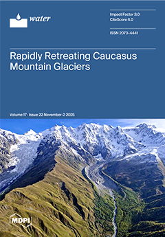
This aerial photograph, taken over the Georgian Caucasus Mountains in September 2024, depicts a high-mountain glaciated landscape undergoing rapid environmental transformation. These features indicate sustained mass loss that has accelerated since the early 2000s, consistent with regional and global trends in glacier recession driven by climate warming. This photograph provides a clear visual example of how warming temperatures reshape high-altitude environments, influencing hydrology, ecology, and the geomorphic evolution of glacierized basins across the region. View this paper
  • Issues are regarded as officially published after their release is announced to the table of contents alert mailing list.
  • You may sign up for e-mail alerts to receive table of contents of newly released issues.
  • PDF is the official format for papers published in both, html and pdf forms. To view the papers in pdf format, click on the "PDF Full-text" link, and use the free Adobe Reader to open them.
Order results
Result details
Section
Select all
Export citation of selected articles as:
25 pages, 4341 KB  
Article
Coordinated Development of Water–Energy–Food–Ecosystem Nexus in the Yellow River Basin: A Comprehensive Assessment Based on Multi-Method Integration
by Jingwei Yao, Kiril Manevski, Finn Plauborg, Yangbo Sun, Lingling Wang, Wenmin Zhang and Julio Berbel
Water 2025, 17(22), 3331; https://doi.org/10.3390/w17223331 - 20 Nov 2025
Viewed by 476
Abstract
The Yellow River Basin serves as a critical ecological barrier and economic corridor in China, playing a pivotal role in national ecological security and sustainable development. This study develops a comprehensive evaluation framework grounded in the Water–Energy–Food–Ecosystem (WEFE) nexus, employing 25 indicators across [...] Read more.
The Yellow River Basin serves as a critical ecological barrier and economic corridor in China, playing a pivotal role in national ecological security and sustainable development. This study develops a comprehensive evaluation framework grounded in the Water–Energy–Food–Ecosystem (WEFE) nexus, employing 25 indicators across nine provinces and autonomous regions over the period 2000–2023. Utilizing a multi-method approach—including the entropy weight method, coupling coordination degree model, center of gravity migration analysis, principal component analysis, and obstacle factor diagnosis—the research investigates the coordinated development and dynamic interactions among the WEFE subsystems. Key findings include: (1) the calculated weights of the water, energy, food, and ecological subsystems were 0.3126, 0.1957, 0.1692, and 0.3225, respectively, indicating that ecological and water subsystems exert the greatest influence; (2) distinct growth patterns among subsystems, with the energy subsystem exhibiting the fastest growth rate (212%) and the water subsystem the slowest (4%); (3) a steady improvement in the overall coordination degree of the WEFE system, rising from 0.417 in 2000 to 0.583 in 2023—a 39.8% increase—with Henan (0.739) and Inner Mongolia (0.715) achieving the highest coordination levels in 2023, while Qinghai (0.434) and Ningxia (0.417) remained near imbalance thresholds; (4) complex spatial dynamics reflected by cumulative center of gravity migration distances of 678.2 km (water), 204.9 km (energy), 143.3 km (food), and 310.9 km (ecology) over the study period; and (5) identification of per capita water resources as the principal limiting factor to coordinated WEFE development, with an obstacle degree of 0.1205 in 2023, underscoring persistent water scarcity challenges. This integrated framework advances WEFE nexus analysis and provides robust, evidence-based insights to inform regional policy and resource management strategies. Full article
(This article belongs to the Special Issue Sustainable Water Management in Agricultural Irrigation)
Show Figures

Figure 1

17 pages, 2494 KB  
Article
Occurrence of Microplastics in Inland and Island Wastewater Treatment Plants and the Role of Suspended Solids as Monitoring Indicators
by Suthida Theepharaksapan, Paranee Sriromreun, Pradabduang Kiattisaksiri, Athit Phetrak, Chalintorn Molee and Suda Ittisupornrat
Water 2025, 17(22), 3330; https://doi.org/10.3390/w17223330 - 20 Nov 2025
Viewed by 408
Abstract
Microplastics (MPs) are increasingly recognized as emerging contaminants in aquatic environments; however, their occurrence and fate in tropical wastewater treatment systems remain poorly understood. This study provides the first inland–island comparison of MP removal in wastewater treatment plants (WWTPs) across Thailand’s Eastern Economic [...] Read more.
Microplastics (MPs) are increasingly recognized as emerging contaminants in aquatic environments; however, their occurrence and fate in tropical wastewater treatment systems remain poorly understood. This study provides the first inland–island comparison of MP removal in wastewater treatment plants (WWTPs) across Thailand’s Eastern Economic Corridor. Influent and effluent samples were collected from six WWTPs, encompassing five treatment types: oxidation ditch, aerated lagoon, stabilization pond, aerated tank, and sand filtration combined with reverse osmosis. Polymeric composition and size distribution were examined in parallel with conventional water quality indicators. Across all sites, polyethylene (PE) and polypropylene dominated influent MPs, together accounting for 57–92% of total abundance. Inland plants received heterogeneous municipal wastewater, including domestic inputs and agricultural runoff. In contrast, island facilities consistently showed PE-enriched influents (45–60%) in site F, reflecting tourism-driven reliance on single-use plastics and personal care products. In addition, several minor polymers were identified, including poly (vinyl stearate) (up to 26%), polyamide, polytetrafluoroethylene and ethylene–butyl acrylate, highlighting overlooked pathways of MP entry into WWTPs. Fine MPs (100–300 μm) comprised over two-thirds of influent particles, with stabilization ponds reaching 16,000 MP m−3. Removal efficiency ranged from 86.0% to 98.5%. Spearman’s correlation and multiple linear regression analyses revealed strong positive relationships between MPs and both total suspended solids (TSS) and turbidity. Suspended solids parameters emerged as the most reliable predictor of MP abundance (adjusted R2 = 0.91, p = 0.001). This finding highlights TSS coupled with turbidity as a practical, cost-effective indicator for monitoring MPs in tropical WWTPs. To achieve greater accuracy, a larger dataset should be built and further analyzed. Full article
(This article belongs to the Section Wastewater Treatment and Reuse)
Show Figures

Figure 1

17 pages, 298 KB  
Article
From Quality to Purpose: Rethinking Groundwater Microbiological Standards for Emergency Urban Water Use
by Pedro Teixeira, Sílvia Costa, João Brandão and Elisabete Valério
Water 2025, 17(22), 3329; https://doi.org/10.3390/w17223329 - 20 Nov 2025
Viewed by 318
Abstract
Climate change and increasing water scarcity are driving the need for resilient and fit-for-purpose urban water management. This study presents a case from Lisbon, Portugal, where twenty-one groundwater sources were evaluated as potential alternative supplies for emergency drinking and non-potable uses. Between 2018 [...] Read more.
Climate change and increasing water scarcity are driving the need for resilient and fit-for-purpose urban water management. This study presents a case from Lisbon, Portugal, where twenty-one groundwater sources were evaluated as potential alternative supplies for emergency drinking and non-potable uses. Between 2018 and 2022, 127 samples were analyzed for microbiological (Escherichia coli, enterococci, fecal coliforms, heterotrophic plate count, Pseudomonas aeruginosa and Legionella pneumophila, physicochemical and fungal parameters (filamentous and yeast), alongside with microbial source tracking (MST) to determine contamination origins. Most sites showed exceedances of fecal indicators and heterotrophic bacteria, making water unsuitable for direct consumption without treatment, while fungi were ubiquitous and often above proposed guidance levels, highlighting a major regulatory gap. MST results indicated that human-derived contamination was rare and highly localized. Physicochemical parameters generally met legal thresholds, although occasional nitrate or salinity elevations reflected agricultural or coastal influences. Several sources were considered suitable for irrigation (EF, CC, AB, VF, and BS) whilst a subset met the criteria for potable supply with minimal treatment for risk management (CG, MM, CC, QC, EB, GR, PO, and MS). The findings of this study demonstrate that systematic, multiparametric assessment supports adaptive water allocation and emergency planning, aligning with EU regulations and advancing Sustainable Development Goal 6. The study argues for reconsideration of current microbiological standards, to improve public health protection in urban water reuse and emergency supply strategies. Full article
(This article belongs to the Special Issue Urban Water Pollution Control: Theory and Technology, 2nd Edition)
17 pages, 3574 KB  
Article
Rooftop-Scale Runoff Reduction Performance of Smart Blue-Green Roofs and Their Potential Role in Urban Flood Mitigation
by Sung Min Cha, Jaerock Park, Kyung Soo Han, Jong Dae Kim, Jung Min Lee, Soonchul Kwon and Jaemoon Kim
Water 2025, 17(22), 3328; https://doi.org/10.3390/w17223328 - 20 Nov 2025
Viewed by 298
Abstract
Urban areas face increasing flood risks due to climate change, intensified rainfall events, and high impervious surface coverage. Blue-Green Roofs (BGR) have emerged as a nature-based solution to retain stormwater, while Smart BGR systems integrate active control functions to enhance performance under varying [...] Read more.
Urban areas face increasing flood risks due to climate change, intensified rainfall events, and high impervious surface coverage. Blue-Green Roofs (BGR) have emerged as a nature-based solution to retain stormwater, while Smart BGR systems integrate active control functions to enhance performance under varying rainfall conditions. This study evaluated the rooftop-scale runoff reduction efficiency of conventional roofs, BGR, and Smart BGR using 31 monitored rainfall events in 2024, while eight years of historical rainfall data (2017–2024) were used only to characterize long-term rainfall patterns in the study area. A multiple-linear regression analysis was performed for exploratory trend identification between rainfall characteristics and runoff reduction; variables unrelated to short-term storm responses such as evapotranspiration or initial storage were beyond the study scope. Results showed that the annual runoff per unit area was 1.115 m3/m2 for conventional roofs, 0.547 m3/m2 for BGR, and 0.128 m3/m2 for Smart BGR, corresponding to reduction rates of 50.98% and 88.53% for BGR and Smart BGR, respectively. In higher rainfall classes, Smart BGR maintained significantly higher performance: for Class 3 (average 53.00 mm), BGR reduced runoff by 54.89% while Smart BGR achieved 86.71%; for Class 4 (average 121.21 mm), the rates were 54.68% and 90.00%, respectively. These findings indicate that Smart BGR’s storage optimization and controlled discharge enable superior effectiveness during intense and prolonged events. The study highlights Smart BGR’s potential as an advanced stormwater management technology, offering clear advantages over both conventional roofs and passive BGR designs. Limitations include the need for testing under more extreme rainfall scenarios, optimization of operational strategies, and economic feasibility assessments. Nevertheless, Smart BGR represents a promising approach for enhancing urban flood resilience in the context of climate change. Full article
(This article belongs to the Special Issue Application of Hydrological Modelling to Water Resources Management)
Show Figures

Figure 1

27 pages, 2345 KB  
Article
Freshwater Phenanthrene Removal by Three Emergent Wetland Plants
by Madeline J. Stanley, Aidan Guttormson, Lisa E. Peters, Thor Halldorson, Gregg Tomy, José Luis Rodríguez Gil, Blake Cooney, Richard Grosshans, David B. Levin and Vince P. Palace
Water 2025, 17(22), 3327; https://doi.org/10.3390/w17223327 - 20 Nov 2025
Viewed by 302
Abstract
The use of floating wetlands has been receiving increased attention as a minimally invasive method for oil spill remediation, but the species of vegetation incorporated in floating wetlands may influence the success of oil degradation. Therefore, a freshwater microcosm experiment was conducted at [...] Read more.
The use of floating wetlands has been receiving increased attention as a minimally invasive method for oil spill remediation, but the species of vegetation incorporated in floating wetlands may influence the success of oil degradation. Therefore, a freshwater microcosm experiment was conducted at the IISD Experimental Lakes Area, Canada to assess the potential of common wetland plants Typha sp., Carex utriculata, and C. lasiocarpa, to remove phenanthrene, a polycyclic aromatic hydrocarbon ubiquitously found at oil spill sites. Triplicate microcosms containing 3L of lake water were established with either Typha sp., Carex utriculata, or C. lasiocarpa and then treated with nominal concentration of 1 mg/L phenanthrene and monitored over 21 days. Two types of reference microcosms were also included: one set with the same plant allocations but not treated with phenanthrene and another with water only and no plants or phenanthrene. Phenanthrene declined by over 89.30% in all microcosms that received the compound, but the decline was more rapid in microcosms that included Typha sp. and C. lasiocarpa, than those with C. utriculate or no plants. Declining phenanthrene concentrations in microcosms without plants may have resulted from biofilm stimulation. Specific conductivity and pH were influenced by plant type but not phenanthrene, while dissolved oxygen was influenced by both. There was no influence of phenanthrene on plant growth rates or root biofilm bioactivity, measured by adenosine triphosphate or oxygen consumption. Results indicate there may be plant-specific factors influencing remediation success which should be explored in future research. Full article
Show Figures

Figure 1

19 pages, 4369 KB  
Article
Spatiotemporal Variation Characteristics of Industrial Structure in the Yellow River Basin, China, and Its Impact on the Water Environment
by Qihao Zhou, Kuo Wang, Xiaojie Bing, Juan Jiang, Sailan He, Qingshuai Song, Fangxi Cui and Yuanrong Zhu
Water 2025, 17(22), 3326; https://doi.org/10.3390/w17223326 - 20 Nov 2025
Viewed by 292
Abstract
The Yellow River Basin (YRB) is a vital water source and an essential ecological barrier in northern China. Currently, it faces pressing challenges related to water resource security and displays pronounced disparities in regional economic development. In recent years, with the elevation of [...] Read more.
The Yellow River Basin (YRB) is a vital water source and an essential ecological barrier in northern China. Currently, it faces pressing challenges related to water resource security and displays pronounced disparities in regional economic development. In recent years, with the elevation of Ecological Protection and High-Quality Development to a national strategy, examining the interaction between industrial growth and water environmental quality within the basin has become a priority. This study focuses on the mainstem of the YRB. By compiling relevant data from 2000 to 2021 and collecting water samples from 20 mainstem sites, and by integrating spatial distribution information of key industrial sectors with water quality records (including representative heavy metals and anions), we found that the basin’s economic output expanded significantly over the past two decades, approximately 11.7 times. The industrial structure evolved across provinces within the basin, exhibiting an overall upward trend in industrial upgrading; nevertheless, substantial differences in industrial composition and transformation persist between the upper and lower reaches. Spatial variations in different industries are closely associated with pollutant concentrations. In particular, major industries in the middle–lower reaches, notably concentrated in regions such as Shandong, possess high total asset values. Output from certain sectors (e.g., petroleum extraction, coal mining and processing, non-metallic mineral mining and processing) is strongly correlated with pollution changes, with marked spatial linkages between their geographic distribution and concentrations of critical heavy metals (Cu, Se, Mo, Mn, Ni). Moreover, spatial analysis of the industry–pollution nexus reveals an apparent paradox in the middle–lower YRB: high industrial output coupled with relatively low levels of heavy metal contamination. This finding highlights the pivotal role of an advanced industrial structure and elevated regional development quality in mediating the balance between economic expansion and environmental pressure. In conclusion, as a globally significant large river basin, the YRB demonstrates a tight coupling between water quality and industrial structure. The results provide spatially explicit scientific evidence and policy guidance for the coordinated advancement of industrial green transformation and water quality improvement in the YRB, offering broader insights into industrial structure patterns and pollution control strategies applicable to major river basins worldwide. Full article
(This article belongs to the Section Water Quality and Contamination)
Show Figures

Figure 1

23 pages, 1631 KB  
Review
Acidic Wastewater from Electrode Foil Manufacturing: Treatment Advances and Future Pathways
by Guodong Wu, Lu Wang, Bing Qin, Fanbin Meng, Yonghu He, Xin Wang, Jing Bai, Jingpeng Zhang and Yuanhao Wang
Water 2025, 17(22), 3325; https://doi.org/10.3390/w17223325 - 20 Nov 2025
Viewed by 381
Abstract
The rapid expansion of the electrode foil industry has led to the generation of large volumes of acidic wastewater containing strong acids (sulfuric and hydrochloric) and metal ions (such as aluminum and copper). The generated wastewater poses serious environmental challenges, including infrastructure corrosion, [...] Read more.
The rapid expansion of the electrode foil industry has led to the generation of large volumes of acidic wastewater containing strong acids (sulfuric and hydrochloric) and metal ions (such as aluminum and copper). The generated wastewater poses serious environmental challenges, including infrastructure corrosion, soil acidification, and toxicity to aquatic life. This review evaluates three primary treatment approaches: neutralization (adjusting pH and removing metals), ion adsorption (selective recovery of metals and acid recycling), and membrane separation (precision resource recovery). Neutralization is cost-effective for pH adjustment and metal removal but is limited by secondary pollution and low resource recovery. Ion adsorption allows for the targeted recovery of metals and recycling of acid, although it faces challenges related to high costs and scalability. Membrane separation offers accurate separation and resource recovery but is affected by fouling and high energy requirements. Future research should focus on integrated treatment strategies, AI-driven process optimization, and the development of advanced materials to enhance sustainable wastewater management. These efforts aim to provide a scientific basis and technical reference for wastewater treatment in the electrode foil industry. Full article
(This article belongs to the Section Wastewater Treatment and Reuse)
Show Figures

Figure 1

22 pages, 7103 KB  
Article
Intelligent Water-Saving Dewatering for High-Rise Building Sites: A Case Study in Taichung, Taiwan
by Jun-Mei Ho, Chia-Ming Fan and Chao-Hsien Liaw
Water 2025, 17(22), 3324; https://doi.org/10.3390/w17223324 - 20 Nov 2025
Viewed by 341
Abstract
Foundation engineering is an essential preliminary stage in high-rise building construction, as it provides the structural load-bearing capacity of the building. Since foundation structures often extend into the subsurface layers, excavation becomes a critical part of construction. When groundwater is encountered during excavation, [...] Read more.
Foundation engineering is an essential preliminary stage in high-rise building construction, as it provides the structural load-bearing capacity of the building. Since foundation structures often extend into the subsurface layers, excavation becomes a critical part of construction. When groundwater is encountered during excavation, it is necessary to lower the groundwater level to provide a dry working environment. However, groundwater is a valuable and clean natural resource. In most high-rise construction projects, large volumes of groundwater are extracted through dewatering operations to maintain dry foundation conditions; therefore, minimizing groundwater extraction is particularly important for conserving this precious resource. In Taiwan, groundwater level monitoring at high-rise construction sites has traditionally relied on manually measuring observation wells using graduated rulers and labor-intensive shift schedules. A few construction companies have adopted continuous groundwater monitoring systems, but these require substantial financial investment and maintenance costs. To address these limitations, this study proposes an artificial intelligence (AI)-based groundwater level simulation model. In particular, artificial neural networks (ANNs) are integrated with fuzzy logic theory to develop a predictive model for dewatering operations in high-rise building foundations. Furthermore, a smart water-saving dewatering model is proposed to overcome the deficiencies of conventional dewatering practices, which typically consume excessive groundwater resources. Full article
(This article belongs to the Section Urban Water Management)
Show Figures

Figure 1

17 pages, 638 KB  
Review
Permeable Pavements: An Integrative Review of Technical and Environmental Contributions to Sustainable Cities
by Eric Franco, Enedir Ghisi, Igor Catão Martins Vaz and Liseane Padilha Thives
Water 2025, 17(22), 3323; https://doi.org/10.3390/w17223323 - 20 Nov 2025
Viewed by 578
Abstract
Rapid urban growth and the expansion of impervious surfaces have intensified environmental issues such as flooding, water pollution, and urban heat islands. Permeable pavements have emerged as a green infrastructure solution to mitigate these impacts and support the sustainable development of cities. The [...] Read more.
Rapid urban growth and the expansion of impervious surfaces have intensified environmental issues such as flooding, water pollution, and urban heat islands. Permeable pavements have emerged as a green infrastructure solution to mitigate these impacts and support the sustainable development of cities. The aim of this study was to conduct an integrative review on the state of the art of permeable pavements, with a focus on their technical and environmental contributions. The methodology followed the PRISMA guidelines, using the Scopus database to select the most cited articles across four thematic areas: Life Cycle Assessment; infiltration capacity and pollutant retention; mitigation of heat islands and flooding; and the impacts of climate and clogging. The results show that, despite the initial cost and production-related impacts, permeable pavements offer long-lasting benefits, including reduced surface runoff, pollutant filtration, and evaporative cooling. The main economic limitations identified were clogging, which decreases system efficiency, and the high implementation cost, highlighting the need for regular maintenance and innovations in materials. In summary, permeable pavements are an effective strategy for sustainable urban development, but their longevity depends on proper design and maintenance. Full article
(This article belongs to the Section Urban Water Management)
Show Figures

Figure 1

18 pages, 8395 KB  
Article
Ensemble Integration of Pedestrian Safety Indicators for Robust Pedestrian Flood Risk Assessment in Urban Inundation Conditions
by Inhwan Park, Dogyu Lee, Jaehyun Shin and Dong Sop Rhee
Water 2025, 17(22), 3322; https://doi.org/10.3390/w17223322 - 20 Nov 2025
Viewed by 287
Abstract
Increasing rainfall intensity and altered temporal patterns due to climate change pose significant threats to pedestrian safety in highly urbanized areas. Reliable pedestrian safety assessment is therefore essential for evacuation planning and flood risk management. This study evaluated pedestrian stability under various rainfall [...] Read more.
Increasing rainfall intensity and altered temporal patterns due to climate change pose significant threats to pedestrian safety in highly urbanized areas. Reliable pedestrian safety assessment is therefore essential for evacuation planning and flood risk management. This study evaluated pedestrian stability under various rainfall patterns and return periods using four instability indicators derived from hydraulic and empirical formulations. To mitigate indicator-dependent variability, the normalized indicators were combined into an integrated instability index through an ensemble-averaging approach. The flood-intensity-based indicator systematically underestimated non-walkable areas compared with force-balance-based indicators, whereas the integrated index produced more consistent spatial patterns of pedestrian risk across rainfall scenarios. The most hazardous conditions occurred under the 1 h, Huff fourth-quartile storm, highlighting the influence of late-peaking rainfall on short-duration urban flooding. These findings demonstrate that the proposed ensemble-averaged framework enhances the robustness of pedestrian flood risk evaluation and provides a quantitative basis for prioritizing mitigation measures and evacuation planning in urban areas. Full article
(This article belongs to the Special Issue Analysis and Simulation of Urban Floods)
Show Figures

Figure 1

26 pages, 7720 KB  
Article
Gross Ecosystem Product (GEP) Accounting and Sustainable Management Pathways for Wild Duck Lake National Wetland Park, Beijing, China
by Yuxuan Cui, Zihan Yang, Qiyuan Zhou, Mingrui Yang, Sen Liang, Jianjun Zhang and Ke Wang
Water 2025, 17(22), 3321; https://doi.org/10.3390/w17223321 - 20 Nov 2025
Viewed by 448
Abstract
The Gross Ecosystem Product (GEP) represents the total value of goods and services supplied by ecosystems, serving as a key indicator that connects ecological well-being with economic development and supports the achievement of sustainable development goals. This study selected Beijing’s Wild Duck Lake [...] Read more.
The Gross Ecosystem Product (GEP) represents the total value of goods and services supplied by ecosystems, serving as a key indicator that connects ecological well-being with economic development and supports the achievement of sustainable development goals. This study selected Beijing’s Wild Duck Lake National Wetland Park as its research subject, establishing a GEP assessment system for two major services: regulating services and cultural services. By integrating market-based valuation approaches with social media data to support the assessment of cultural services, this study calculated the 2023 GEP of the wetland park. Finally, based on the social media data and the GEP accounting results, value enhancement strategies for Wild Duck Lake National Wetland Park were proposed. Key findings include: (1) The total GEP of Wild Duck Lake National Wetland Park reached 155.01 million CNY in 2023, with a per-unit-area value of 35.47 million CNY/km2. (2) Among regulating services, climate regulation and water purification were the primary contributors, accounting for 66.10% and 11.76% of the total value, respectively. Cultural service value primarily derived from tourism and health preservation services. (3) Social media analysis showed that visitors valued the park’s natural landscapes while noting service and facility shortcomings, indicating a balanced assessment combining both positive and negative perceptions. (4) Based on GEP assessment and social perception analysis, this study provides pathways for realizing the ecosystem service value of Wild Duck Lake National Wetland Park from three aspects. The main contribution of this study lies in developing an integrated framework for GEP accounting and enhancement in national wetland parks, providing a scientific foundation for their sustainable development. Full article
(This article belongs to the Section Biodiversity and Functionality of Aquatic Ecosystems)
Show Figures

Figure 1

20 pages, 10525 KB  
Article
The Construction of Check Dams on the Loess Plateau Has Prolonged Water Transmission Times and Altered Recharge Relationships
by Yi Sun, Yi Zhang, Xiao-Jun Liu, Chen Meng, Yu-Ting Cheng and Jing Wang
Water 2025, 17(22), 3320; https://doi.org/10.3390/w17223320 - 20 Nov 2025
Viewed by 316
Abstract
Background: As a key structure for gully control on the Loess Plateau, check dams are designed to intercept sediment and reduce flood peaks without intentional water storage. However, persistent ponding zones have often formed upstream of dams in the Niejia River Basin, exceeding [...] Read more.
Background: As a key structure for gully control on the Loess Plateau, check dams are designed to intercept sediment and reduce flood peaks without intentional water storage. However, persistent ponding zones have often formed upstream of dams in the Niejia River Basin, exceeding their intended functionality. Methods: This study examines the basin using hydrogen and oxygen stable isotopes to trace hydrological processes. Based on 251 water samples, mixing models and exponential fitting were applied to quantify water sources and transmission times. Results: Results show that precipitation (47.07%) and groundwater (34.48%) are the main sources of channel water. Check dams extended water transmission time in dammed tributaries to 489 days—2.8 times longer than in undammed ones. Conclusions: This delay enhances watershed storage capacity, providing insight into the hydrological impacts of check dams on the Loess Plateau. Full article
(This article belongs to the Special Issue Soil Erosion and Soil and Water Conservation, 2nd Edition)
Show Figures

Figure 1

17 pages, 10025 KB  
Review
Recent Advances in Sewer Biofilms: A Perspective on Bibliometric Analysis
by Linjun Zhang, Jinbiao Liu, Guoqiang Song, Shuchang Huang, Claudia Li and Jaka Sunarso
Water 2025, 17(22), 3319; https://doi.org/10.3390/w17223319 - 20 Nov 2025
Viewed by 308
Abstract
The long-distance transport of wastewater in sewers inevitably leads to the formation of biofilms on the inner wall of sewers. Numerous studies have focused on analyzing the hydrogen sulfide, methane production, and emission patterns associated with sewer biofilms in sewer systems. This study [...] Read more.
The long-distance transport of wastewater in sewers inevitably leads to the formation of biofilms on the inner wall of sewers. Numerous studies have focused on analyzing the hydrogen sulfide, methane production, and emission patterns associated with sewer biofilms in sewer systems. This study employed bibliometric methods to analyze the research progress in the field of sewer biofilms from 1995 to 2025, and revealed the associated development trend, international cooperation network, and research hotspots. The results demonstrate a substantial increase in the number of annual publications over the past decade, with China and Australia as the primary contributors. The journal Water Research has been found to exert a significant influence. The research hotspots concentrate on the generation and control of hydrogen sulfide and methane, sewer corrosion mechanisms, and microbial community dynamics, with chemical dosing, sulfate-reducing bacteria, and biofilm metabolism as the key directions. The evolution of keywords demonstrates that early research focused on organic matter transformation, and in recent years, there has been a shift towards microbial ecology and wastewater epidemiology, along with other emerging areas. Recent years have seen China as well as China’s institution and authors emerge as the primary contributors in the sewer biofilm field, a development attributable to the country’s policy support, which has precipitated the development of green technologies and smart monitoring systems. This study demonstrates the necessity of international cooperation and provides theoretical references and technological directions for future sewer biofilms research. Full article
(This article belongs to the Section Wastewater Treatment and Reuse)
Show Figures

Figure 1

19 pages, 2110 KB  
Article
Empowering Sustainability Through AI-Driven Monitoring: The DEEP-PLAST Approach to Marine Plastic Detection and Trajectory Prediction for the Black Sea
by Alexandra Cernian and Miruna-Elena Iliuta
Water 2025, 17(22), 3318; https://doi.org/10.3390/w17223318 - 20 Nov 2025
Viewed by 432
Abstract
Marine plastic pollution represents a critical ecological challenge, exerting long-lasting impacts on ecosystems, biodiversity, and human well-being. This study introduces the DEEP-PLAST project, an integrated AI-based framework designed for the detection and trajectory prediction of floating marine plastic waste using open-access Sentinel-2 satellite [...] Read more.
Marine plastic pollution represents a critical ecological challenge, exerting long-lasting impacts on ecosystems, biodiversity, and human well-being. This study introduces the DEEP-PLAST project, an integrated AI-based framework designed for the detection and trajectory prediction of floating marine plastic waste using open-access Sentinel-2 satellite imagery and environmental models of ocean currents and wind. The DEEP-PLAST methodology integrates object detection (YOLOv5 on UAV data), semantic segmentation (U-Net/U-Net++ on Sentinel-2), and drift simulation using Copernicus and NOAA datasets. U-Net++ achieved the best performance (F1 = 0.84, false positive rate 5.2%), outperforming other models. Detected debris locations were linked to Lagrangian drift models to identify accumulation zones in the Black Sea, supporting targeted cleanup efforts. While promising, drift validation remains qualitative due to limited ground truth, to be addressed in future work with in situ and NGO data. This approach supports EU Mission Ocean, the Marine Strategy Framework Directive, and UN SDGs, demonstrating the potential of AI and remote sensing for marine protection. Future efforts will expand datasets, apply the platform to other seas, and launch a web tool for NGOs and policymakers. Full article
(This article belongs to the Special Issue Remote Sensing in Coastal Water Environment Monitoring)
Show Figures

Figure 1

19 pages, 3353 KB  
Article
Intelligent Management of Fracturing Knowledge in Oil and Gas Fields: A Novel Transformation Approach from Document Governance to Natural Language Q&A
by Jie Li, Jiale Pu, Zhihua Zhu, Gensheng Li, Maoya Xu, Xiaodong He, Shengjiang Xu, Shouceng Tian and Tianyu Wang
Water 2025, 17(22), 3317; https://doi.org/10.3390/w17223317 - 20 Nov 2025
Viewed by 292
Abstract
Digitalization and intelligence have become pivotal in the realm of oil and gas field development, concomitant with a marked increase in the volume of fracturing-related documentation, the majority of which exists in unstructured form. This has given rise to inefficiencies in data governance [...] Read more.
Digitalization and intelligence have become pivotal in the realm of oil and gas field development, concomitant with a marked increase in the volume of fracturing-related documentation, the majority of which exists in unstructured form. This has given rise to inefficiencies in data governance and knowledge utilization. To address this, the paper proposes an integrated technical approach of “document governance—knowledge extraction—intelligent Q&A.” We first achieve document standardization through multi-format document parsing and semantic segmentation. Subsequently, by leveraging a knowledge dictionary and the Qwen3-14B (Q8 precision) large language model, the accuracy of professional information extraction is enhanced via keyword positioning and dynamic prompt strategies, achieving an extraction accuracy of 95% and a recall rate of 80%. This provides data and knowledge support for building a structured database and a vector knowledge base. Finally, a natural language Q&A system based on a structured query language agent (SQLAgent) is developed, achieving a Q&A accuracy of over 92%, a response time of less than 30 s, and support for interactive querying of complex questions. We offer a practical technical pathway for the intelligent management and knowledge services of fracturing engineering documents. Full article
Show Figures

Figure 1

21 pages, 5570 KB  
Article
Numerical Analysis of 3D Slope Stability in a Rainfall-Induced Landslide: Insights from Different Hydrological Conditions and Soil Layering
by Guoding Chen, Xiuguang Wu, Linlin Hu, Yunfei Chi, Tianlong Jia and Yi Luo
Water 2025, 17(22), 3316; https://doi.org/10.3390/w17223316 - 20 Nov 2025
Viewed by 416
Abstract
The analysis of rainfall-induced landslides, which involve complex interactions between hydrology, soil mechanics, and geometry, is still limited by simplifying assumptions in existing models. We introduced a numerical model that couples soil infiltration with three-dimensional (3D) slope stability analysis. After validating against benchmark [...] Read more.
The analysis of rainfall-induced landslides, which involve complex interactions between hydrology, soil mechanics, and geometry, is still limited by simplifying assumptions in existing models. We introduced a numerical model that couples soil infiltration with three-dimensional (3D) slope stability analysis. After validating against benchmark problems, we used this model to investigate the effects of various hydro-geotechnical conditions on slope stability. The results show that rainfall intensity dictates the stability of shallow landslides, while for deep-seated landslides, it governs the rate of progression toward failure. A high initial groundwater table reduces slope stability by accelerating soil weakening, particularly for deep landslides. Although upward moisture redistribution via matric suction is possible, its effect is negligible during infiltration, allowing deep saturation and landslide risk to persist. Furthermore, a low-permeability basal layer impedes drainage, leading to pore pressure buildup and a rapid decline in stability. The proposed model could potentially overcome the limitations in predictive accuracy of current hydro-geotechnical models arising from their oversimplified representations. Full article
(This article belongs to the Special Issue Water-Related Landslide Hazard Process and Its Triggering Events)
Show Figures

Figure 1

20 pages, 16556 KB  
Article
Renaturalization Drives Hydromorphological Recovery in Degraded Gravel-Bed Streams in Poland
by Paweł Mikuś
Water 2025, 17(22), 3315; https://doi.org/10.3390/w17223315 - 20 Nov 2025
Viewed by 448
Abstract
The systematic regulation of Polish gravel-bed watercourses, notably intensified in the latter half of the 20th century, coupled with extensive gravel extraction, have become one of the main factors leading to severe channel incision and degradation of hydromorphological features. This paper investigates river [...] Read more.
The systematic regulation of Polish gravel-bed watercourses, notably intensified in the latter half of the 20th century, coupled with extensive gravel extraction, have become one of the main factors leading to severe channel incision and degradation of hydromorphological features. This paper investigates river renaturalization as a pivotal strategy to restore channel-riparian water connectivity in incised gravel-bed streams of Southern Poland. The river restoration projects were categorized into passive and active techniques. Passive methods, though less common, involve cost-effective methods like the restoration of erodible corridors, island-braided channel patterns, and woody debris presence, while active methods include mainly fish passes, check dam lowering, and artificial riffles. A total of 27 major activities carried out on rivers of Southern Poland were assessed, revealing a trend towards comprehensive renaturalization in collaboration with scientists, pro-environment organizations, and local authorities and communities. Despite the lack of long-term data for most projects, results demonstrated sustained improvements in hydromorphological features, including the shallowing and stabilization of deeply incised channels. Using a natural section of the Czarny Dunajec river, a brief case study was presented to explain the mechanism of spontaneous river renaturalization. It was also shown that a good restoration project should take into account the views of all river stakeholders, anticipate possible development trajectories of a freely migrating river, and assess the potential benefits for both nature and people. Increased deposition of macroplastics together with woody debris in naturally widened river sections, as well as the possible remobilization of pollutants previously trapped in bank sediments, presents an additional challenge for future projects. Full article
Show Figures

Figure 1

15 pages, 4170 KB  
Article
Simulation of the Telluric Electrical Field Frequency Selection Method and Its Application in Mineral Water Exploration
by Tianchun Yang, Zhu Yang, Qin Qin, Theophilus Aanuoluwa Adagunodo and Maoyue Zhu
Water 2025, 17(22), 3314; https://doi.org/10.3390/w17223314 - 20 Nov 2025
Viewed by 232
Abstract
In practical engineering geophysics, anomalous bodies are typically three-dimensional (3-D) structures, making it inaccurate to represent the subsurface geoelectric model using a two-dimensional (2-D) assumption. Furthermore, the underlying mechanism of the telluric electrical field frequency selection method (TEFSM) remains insufficiently understood. To address [...] Read more.
In practical engineering geophysics, anomalous bodies are typically three-dimensional (3-D) structures, making it inaccurate to represent the subsurface geoelectric model using a two-dimensional (2-D) assumption. Furthermore, the underlying mechanism of the telluric electrical field frequency selection method (TEFSM) remains insufficiently understood. To address these limitations, this study presents a 3-D forward modeling algorithm based on the edge-based finite element method to solve the TEFSM forward problem. This paper also investigates the application of TEFSM in mineral water exploration, striving to minimize the influence of strong electromagnetic interference sources such as high-voltage power lines. Specifically, the paper presents the forward theory of TEFSM and analyzes the causes of galvanic distortion, particularly static shift. Numerical simulations examine the response characteristics of anomalous bodies and the influence of galvanic distortion. The results indicate that galvanic distortion enhances shallow local anomalies in the modulus of the electric field while masking deeper targets. In contrast, the phase of the electric field effectively reflects deeper anomalous bodies and is minimally affected by galvanic distortion. Future improvements in frequency selectors may enable reliable phase measurements, thereby enhancing data interpretability. Subsequently, the TEFSM was applied to field data collected during mineral water exploration. The field test results confirm the effectiveness of TEFSM and demonstrate that it is a portable, simple, low-cost, and highly efficient method for groundwater detection. Full article
Show Figures

Figure 1

16 pages, 2012 KB  
Article
A Spatio-Temporal Assessment of Industrial Water Use in African Countries
by Edwin Kipkirui, Jianfu Zhao, Sha Lu, Duncan Onyango Mbuge and Tao Wang
Water 2025, 17(22), 3313; https://doi.org/10.3390/w17223313 - 20 Nov 2025
Viewed by 345
Abstract
Africa’s industries have been developing at a pace more rapid than other continents, including Asia, over the past two to three decades. This research investigated the industrial water use in 1987–2017 in twenty major African countries, representing 77% of the population and 81% [...] Read more.
Africa’s industries have been developing at a pace more rapid than other continents, including Asia, over the past two to three decades. This research investigated the industrial water use in 1987–2017 in twenty major African countries, representing 77% of the population and 81% of the GDP in Africa. A decoupling analysis of industrial water use from economic growth was also carried out, and hierarchical cluster analysis (HCA) was conducted. The key findings included the following: (i) HCA could divide the patterns of the countries’ water use into four groups. The group of Algeria, Tunisia, Angola, and Morocco exhibited the highest average industrial water use per capita in 2017. (ii) An expansive negative decoupling became more significant during the 10-year period from 2008 to 2017. (iii) Population growth, economic development, and industrial structure played a prominent role in driving industrial water use over the past two decades. (iv) Technological advancements in water conservation varied across countries and periods. Some countries, including Kenya, South Africa, Ghana, Egypt, and Tunisia, witnessed a more rapid increase in water withdrawal from 2008 to 2017, but less significant progress in water-saving technologies. This research might be informative for decision-makers to formulate sustainable water policies in line with Africa’s sustainable agenda by the year of 2063. Full article
Show Figures

Figure 1

15 pages, 6646 KB  
Article
Contrasting Fauna in Two Neighboring Territories of the African Horn: A Case of the Genus Moina Baird, 1850 (Cladocera: Moinidae)
by Dmitry D. Pereboev, Anna N. Neretina, Petr G. Garibian, Boris D. Efeykin, Idriss Okiye Waais and Alexey A. Kotov
Water 2025, 17(22), 3312; https://doi.org/10.3390/w17223312 - 19 Nov 2025
Viewed by 330
Abstract
Representatives of the family Moinidae (Crustacea: Cladocera) are well-adapted to life in temporary waters. Different species are characteristic of the Arid Belt of Eurasia. We aimed to compare the moinid species composition and genetic diversity found in Djibouti (with extreme and uniform environments) [...] Read more.
Representatives of the family Moinidae (Crustacea: Cladocera) are well-adapted to life in temporary waters. Different species are characteristic of the Arid Belt of Eurasia. We aimed to compare the moinid species composition and genetic diversity found in Djibouti (with extreme and uniform environments) with neighboring Ethiopia (a relatively large country with diverse environmental conditions). Any cladocerans were found in only four localities in Djibouti from Ecoregion 527 (Western Red Sea Drainages) according to Abell et al. (2008). The moinids belonged to two taxa: M. cf. micrura and M. heilongjiangensis. In Ethiopia, moinids were found in 28 water bodies from four other Ecoregions (522, 525, 526 and 528). They belonged to M. micrura and M. belli. A genetic study based on full mitogenomes, sequences of the mitochondrial COI and nuclear ITS1 loci demonstrated that M. micrura from Djibouti and Ethiopia belong to distant lineages. Our genetic analysis revealed a very contrasting moinid fauna in two neighboring countries of the African Horn: there was no single haplotype, clade or even species sharing these territories. We have revealed unexpectedly small genetic distances between Chinese (type locality) and Djiboutian populations of M. heilongjiangensis; the question of the invasive status of the latter could therefore be raised. Moreover, the status of M. micrura populations from the Rift Valley also needs to be checked; they could be non-indigenous, as they belong to “European” M. micrura s. str. Finally, we have demonstrated that M. cf. micrura is not a monophyletic clade. Full article
(This article belongs to the Topic Taxonomy and Ecology of Zooplankton)
Show Figures

Figure 1

24 pages, 6164 KB  
Article
Toward a Localized Water Footprint of Lithium Brine Extraction: A Case Study from the Salar de Atacama
by Andreas Link, Sylvia Marinova, Lindsey Roche, Vlad Coroamă, Lily Hinkers, Denise Borchardt and Matthias Finkbeiner
Water 2025, 17(22), 3311; https://doi.org/10.3390/w17223311 - 19 Nov 2025
Viewed by 611
Abstract
The extraction of lithium from salt flats such as the Salar de Atacama (SdA) has raised concerns about its potential impact on the local water balance. This study evaluates the possibility of including localized mining impacts on groundwater tables, lagoons, brine–freshwater mixing, evaporation, [...] Read more.
The extraction of lithium from salt flats such as the Salar de Atacama (SdA) has raised concerns about its potential impact on the local water balance. This study evaluates the possibility of including localized mining impacts on groundwater tables, lagoons, brine–freshwater mixing, evaporation, precipitation feedback, and recharge in a localized water footprint case study of lithium mining in the SdA. Using ready-to-use hydrogeological models, we primarily assessed the effects of lithium extraction on groundwater levels, evaporation, precipitation, and basin recharge dynamics. The influence on evaporation and recharge appears to be limited, with surplus evaporation due to mining accounting for a maximum of 4% of basin-wide evaporation. Regarding groundwater tables, drawdown exceeding 25 cm to several meters has largely been confined to areas that are not critical for local ecosystems. Available hydrogeological models have also helped to estimate whether the extraction of freshwater by mining companies can exacerbate groundwater drawdown during brine extraction. Consequently, non-overlapping, geographically distinct depression cones have been identified, but total water consumption by all users in the basin has not been considered. Furthermore, the aspect of model uncertainty requires further investigation, as do changes in lagoon areas and brine–freshwater mixing, which are not yet comprehensively captured by existing models. Full article
(This article belongs to the Section Water Use and Scarcity)
Show Figures

Figure 1

21 pages, 17826 KB  
Article
Experimental Study on the Effectiveness of Grouting in Controlling Breaching of High-Permeability Landslide Dams of Granular Materials
by Peimin Rao, Xing Gao, Hongwei Zhou, Longyang Pan, Baoquan Yang and Liang Li
Water 2025, 17(22), 3310; https://doi.org/10.3390/w17223310 - 19 Nov 2025
Viewed by 410
Abstract
The barrier lake formed by the high-speed landslide that blocks the river typically faces a high risk of failure due to its loose and fragmented structure, high permeability, and weak erosion resistance. Based on the characteristics of this type of landslide dam, this [...] Read more.
The barrier lake formed by the high-speed landslide that blocks the river typically faces a high risk of failure due to its loose and fragmented structure, high permeability, and weak erosion resistance. Based on the characteristics of this type of landslide dam, this paper proposes a new method for emergency rescue of barrier lake outburst by grouting inside the dam. Through 16 groups of experiments, the effects of three key parameters—grouting depth, grouting point arrangement, and layout position—on outburst control were systematically studied, and the mechanism by which grouting technology reduces outbursts was clarified. The results show that the inhibitory effect of the grouting consolidation body on particle initiation and transport, as well as the water-blocking effect caused by guiding water flow around, can fundamentally explain the good flood detention performance of grouting technology by reducing the flow section, limiting breach widening, and narrowing water flow. The depth and position of grouting are key factors for the peak clipping effect. The grouting point should be accurately positioned in the key area subjected to water flow erosion (on the breach side), allowing for a more effective blocking effect with fewer grouting points. When the grouting points are concentrated on the breach side, there is an optimal threshold for the number of grouting points, and benefits diminish after this limit is exceeded. The results can be used for emergency rescue and engineering measures related to the landslide dam. Full article
(This article belongs to the Section Hydraulics and Hydrodynamics)
Show Figures

Figure 1

20 pages, 4928 KB  
Article
The Impact of Catastrophic Flooding on Nitrogen Sources Composition in an Intensively Human-Impacted Lake: A Case Study of Baiyangdian Lake
by Yan Zhang, Xianglong Hou, Lingyao Meng, Yunxia Wang, Shaopeng Ma and Jiansheng Cao
Water 2025, 17(22), 3309; https://doi.org/10.3390/w17223309 - 19 Nov 2025
Viewed by 272
Abstract
Urban development and intensive human activities have led to increasingly prominent nitrogen pollution issues in the Baiyangdian Lake basin. Accurately identifying the sources of nitrate pollution is a crucial prerequisite for implementing targeted remediation strategies, while flooding further complicates this task by exacerbating [...] Read more.
Urban development and intensive human activities have led to increasingly prominent nitrogen pollution issues in the Baiyangdian Lake basin. Accurately identifying the sources of nitrate pollution is a crucial prerequisite for implementing targeted remediation strategies, while flooding further complicates this task by exacerbating the transport and mixing of multi-source pollutants within the basin. This study, conducted from August to October 2023 (encompassing flood and post-flood periods), established 20 sampling sites in the lake area and its major inflow rivers. By integrating hydrochemical parameters, nitrate dual-isotope tracers (δ15N-NO3 and δ18O-NO3), and the Bayesian mixing model (MixSIAR), we quantitatively revealed the contributions of nitrate sources and their response mechanisms to a major flood event. The results indicate that domestic sewage and livestock wastewater (Manure & Sewage, MS) were the dominant sources of nitrate, with an average contribution of 84.0%, which further increased to 90.3% after the flood. Soil nitrogen was a secondary source (average 12.3%), while contributions from chemical fertilizers and atmospheric deposition were negligible (<4%). The results quantified a flood-driven dynamic response process of the nitrate source structure, characterized by “dilution-mixing-pollution rebound-process transformation”: the initial flood stage (August) showed multi-source mixing; the post-flood period (September) witnessed a rapid rebound of sewage sources; and during the October, nitrification persisted, but the basin’s overall denitrification capacity was limited, indicating a risk of nitrogen accumulation. Spatially, rivers like the Fu River were identified as key input pathways. This study revises the traditional understanding by emphasizing the absolute dominance of sewage sources after extreme hydrological events and the risk of insufficient denitrification capacity. The findings provide a scientific basis for water quality management in Baiyangdian and similar lakes. Full article
Show Figures

Figure 1

16 pages, 2235 KB  
Article
Enhanced Sulfate Removal from Acid Mine Drainage via Pre-Cultured Sulfate-Reducing Bacteria and Bioaugmentation Strategies
by Lei Zhang, Bo Li, Tianwei Qian, Xiaona Liu, Haoqing Zhang, Yue Wang, Wenjun Li, Hucheng Huang, Cong Cao and Chunfan Yang
Water 2025, 17(22), 3308; https://doi.org/10.3390/w17223308 - 19 Nov 2025
Viewed by 453
Abstract
Acid mine drainage (AMD), characterized by low pH and high sulfate concentrations, poses severe environmental risks. Sulfate-reducing bacteria (SRB) are promising for AMD bioremediation, but their activity is often inhibited in such extreme conditions. This study proposed two strategies—SRB pre-cultivation and SRB-enhanced sediment [...] Read more.
Acid mine drainage (AMD), characterized by low pH and high sulfate concentrations, poses severe environmental risks. Sulfate-reducing bacteria (SRB) are promising for AMD bioremediation, but their activity is often inhibited in such extreme conditions. This study proposed two strategies—SRB pre-cultivation and SRB-enhanced sediment amendment—to address this limitation, and systematically examined the effects of sulfate concentration, pH, inoculum size, and carbon source on sulfate removal. Results showed that pre-cultivation significantly improved SRB’s acid tolerance, expanding the effective AMD treatment pH range from 6.8–8.8 to 4.8–8.8. At pH 7.8, pre-cultivated SRB achieved 50% removal of 11,760 mg/L sulfate within 24 h and complete removal within 150 h. The SRB-enhanced sediment system further enabled efficient and stable remediation of real AMD (sulfate removal > 97%, Fe/Mn co-removal > 90%). This work provides a practical solution to overcome SRB inhibition in harsh AMD environments and contributes to the development of low-cost, sustainable AMD bioremediation technologies. Full article
(This article belongs to the Section Soil and Water)
Show Figures

Figure 1

21 pages, 5461 KB  
Article
Multi-Scale Mechanisms for Permeability Evolution in Remolded Fault Gouge: From Mineral-Particle Migration to Pore Structure
by Yuanyang Zhao, Huimin Wang, Shaobo Qiao, Zhihan Li and Jinchang Sheng
Water 2025, 17(22), 3307; https://doi.org/10.3390/w17223307 - 19 Nov 2025
Viewed by 300
Abstract
Permeability evolution in remolded fault gouge creates critical uncertainties in geotechnical parameterization for dam foundations. However, the underlying multi-scale mechanisms, including mineral migration and pore structure changes, remain insufficiently understood. This study investigates these mechanisms using remolded plastic-thrust fault gouge from the Yulong [...] Read more.
Permeability evolution in remolded fault gouge creates critical uncertainties in geotechnical parameterization for dam foundations. However, the underlying multi-scale mechanisms, including mineral migration and pore structure changes, remain insufficiently understood. This study investigates these mechanisms using remolded plastic-thrust fault gouge from the Yulong Kashi hydropower project in China. We developed an innovative sample preparation method that combines in situ mineral self-cementation and directional compaction. The study integrated multidisciplinary tests including field in situ permeability tests; seepage–stress coupling tests; and micro-scale NMR/XRD/SEM-EDS analyses. Results demonstrate that remolded samples exhibit 1–2 orders of magnitude lower permeability (10−7 cm/s) than in situ samples (10−5 cm/s). This significant reduction is primarily caused by the loss of cementing agents and the uniform compaction of remolded samples, which leads to degraded pore connectivity. SEM-EDS analysis highlighted the leaching of cementing materials (such as K+, Ca2+ ions), while XRD revealed changes in mineral composition, with chlorite dissolution being the primary mineral alteration associated with permeability decay. Additionally, artificially enhanced cohesion distorted the mechanical behavior of the samples. These findings provide an explanation for why conventional laboratory tests tend to underestimate in situ permeability and overestimate shear strength in fault zones. This study establishes microstructure-informed correction frameworks for hydraulic and mechanical parameters in fault-crossing hydraulic engineering applications Full article
(This article belongs to the Special Issue Numerical Modeling of Hydrodynamics and Sediment Transport)
Show Figures

Figure 1

12 pages, 427 KB  
Communication
Mystique and Pristine Microbiome of Jeju Lava (Yongam) Seawater: Comparative Insights with Mineral Water and Adjacent Seawater
by So-Hyun An, Kwang-Hyo Ko, Won-Guk Jang and Chang-Gu Hyun
Water 2025, 17(22), 3306; https://doi.org/10.3390/w17223306 - 19 Nov 2025
Viewed by 350
Abstract
Jeju lava (Yongam) seawater, naturally filtered through multi-layered basaltic strata, represents a distinctive marine water type that combines mineral enrichment with isolation from surface contaminants. This study aimed to evaluate its microbial purity and ecological transition during mineral water production. Using 16S rRNA-based [...] Read more.
Jeju lava (Yongam) seawater, naturally filtered through multi-layered basaltic strata, represents a distinctive marine water type that combines mineral enrichment with isolation from surface contaminants. This study aimed to evaluate its microbial purity and ecological transition during mineral water production. Using 16S rRNA-based metagenomic sequencing, the microbial communities of Yongam seawater, its derived mineral water, and adjacent natural seawater were analyzed and compared. The Yongam seawater microbiome was dominated by Neptuniibacter pectenicola (≈89%), indicating an extremely pristine and selective microbial environment. In contrast, the mineral water exhibited the emergence of Nocardioides marinus and Limnobacter alexandrii, species associated with oxidative metabolism and environmental adaptability, reflecting microbial adjustment to altered ionic and nutrient conditions. Adjacent seawater contained the highest taxonomic diversity, consistent with its dynamic environmental exposure. These results demonstrate the exceptional microbial purity of Jeju Yongam seawater and the ecological stability of its derived mineral water following processing. The pristine nature of Yongam seawater suggests its potential as a naturally uncontaminated marine resource, while the derived mineral water, maintaining a stable microbial profile, may be suitable for safe and functional utilization in marine-based cosmetic, nutraceutical, and biotechnology applications. Full article
(This article belongs to the Special Issue Marine Waters for Health and Well-Being)
Show Figures

Figure 1

23 pages, 6924 KB  
Article
Adsorption Ability of Soft Magnetic FeCo Alloys for Microplastics
by Shenghao Zhang, Lan Zhang, Xingfu Wang, Pinhua Xia, Zhenming Zhang, Xianfei Huang and Xuetao Guo
Water 2025, 17(22), 3305; https://doi.org/10.3390/w17223305 - 19 Nov 2025
Viewed by 309
Abstract
Microplastics pose significant threats to human health and the environment, and environmentally friendly, efficient, and reliable technologies are needed to remove them from the environment. To explore the potential for metal nanoadsorbents to remove microplastics (MPs) from water, soft magnetic FeCo alloys were [...] Read more.
Microplastics pose significant threats to human health and the environment, and environmentally friendly, efficient, and reliable technologies are needed to remove them from the environment. To explore the potential for metal nanoadsorbents to remove microplastics (MPs) from water, soft magnetic FeCo alloys were successfully synthesized and loaded onto carboxymethyl cellulose. The adsorption performance and mechanisms of soft magnetic FeCo alloys on typical microplastic pollutants, specifically polyethylene microplastics, were systematically studied. Characterization work performed through scanning electron microscopy, an X-ray diffraction analysis and Brunner−Emmett−Teller measurements (SEM, XRD and BET, respectively) confirmed that soft magnetic FeCo alloys possess a typical solid solution structure, abundant hydroxyl functional groups, and a high BET surface area of 142.8302 m2/g, providing sufficient active sites for MP adsorption. At 35 °C, the equilibrium adsorption capacity reached 120.92 mg/g, with a removal rate of 89.33% at a sufficient adsorbent concentration (0.5 g/L); the adsorption kinetics followed a pseudo-second-order kinetic model (R2 > 0.99). Additionally, the adsorption isotherm conformed to the Freundlich model (R2 = 0.969), demonstrating multilayer adsorption characteristics. Furthermore, X-ray photoelectron spectroscopy and Fourier-transform infrared spectroscopy (XPS and FTIR analyses, respectively) indicated that the surface of FeCo is hydrophilic because of catalytic oxidation reactions, resulting in the exposure of polar groups (such as carboxyl and hydroxyl groups) on the microplastic surface, which form hydrogen bonds with oxygen or water molecules on the FeCo surface. The resulting redox vacancies provide ample active sites for the adsorption of microplastics. This study confirms the high microplastic adsorption capacity of soft magnetic FeCo alloys in aquatic environments. Full article
(This article belongs to the Section Wastewater Treatment and Reuse)
Show Figures

Figure 1

13 pages, 534 KB  
Article
Modeling Solar Radiation Data for Reference Evapotranspiration Estimation at a Daily Time Step for Poland
by Dorota Mitrowska, Małgorzata Kleniewska and Leszek Kuchar
Water 2025, 17(22), 3304; https://doi.org/10.3390/w17223304 - 19 Nov 2025
Viewed by 405
Abstract
The Penman–Monteith formula (P-M) is a well-established indirect method for estimating reference evapotranspiration (ET0). The key input for this equation is global solar radiation (H). When real data are unavailable, other weather parameters are used to estimate H. In this study, [...] Read more.
The Penman–Monteith formula (P-M) is a well-established indirect method for estimating reference evapotranspiration (ET0). The key input for this equation is global solar radiation (H). When real data are unavailable, other weather parameters are used to estimate H. In this study, sixteen years’ worth daily registers of H, sunshine duration (S), and air temperature (t) from 10 sites across Poland were used to determine coefficients for the Angström–Prescott (A-P) and Hargreaves–Sammani (H-S) equations. The H values obtained with locally calibrated, general Polish and global A-P and H-S equations were applied to the P-M formula. The ET0 results thus obtained were compared to those derived with the P-M method and measured solar radiation data. The method of determination of the radiation component had a significant but sometimes unexpected impact on the ET0 values. The better predictive power of the solar radiation model usually resulted in better accuracy of the evapotranspiration estimation; however, there were exceptions to this rule. Full article
(This article belongs to the Section Hydrology)
Show Figures

Figure 1

1 pages, 108 KB  
Correction
Correction: Sui et al. Study on the Risk Assessment Method of Rainfall Landslide. Water 2022, 14, 3678
by Haoyue Sui, Tianming Su, Ruilin Hu, Dong Wang and Zhengwei Zheng
Water 2025, 17(22), 3303; https://doi.org/10.3390/w17223303 - 19 Nov 2025
Viewed by 203
Abstract
In the original publication [...] Full article
(This article belongs to the Section Water Erosion and Sediment Transport)
18 pages, 1859 KB  
Article
Spatio-Temporal Analysis of Structural Sediment Connectivity in a Dryland Catchment of the Pamir Mountains
by Haniyeh Asadi, Roy C. Sidle and Arnaud Caiserman
Water 2025, 17(22), 3302; https://doi.org/10.3390/w17223302 - 18 Nov 2025
Viewed by 361
Abstract
Sediment connectivity constitutes a valuable metric to assess the most likely areas of sediment transport, providing a preliminary estimate of the areas to be prioritized for sediment control interventions. Assessment spatio-temporal variability in sediment connectivity can help decrease uncertainties in interpreting sediment transport [...] Read more.
Sediment connectivity constitutes a valuable metric to assess the most likely areas of sediment transport, providing a preliminary estimate of the areas to be prioritized for sediment control interventions. Assessment spatio-temporal variability in sediment connectivity can help decrease uncertainties in interpreting sediment transport and sediment yield within a catchment. In this regard, we evaluated variations in the index of sediment connectivity (IC) based on a well-established approach in the Gunt River catchment. To achieve a more effective assessment of the temporal variations in IC, we considered changes in surface soil moisture (SSM) along with normalized difference vegetation index (NDVI) in July 2015 and 2024. Also, to better represent and more accurately assess IC within this large catchment (13,700 km2), we applied weighted mean IC values (as a novel metric) based on iso-IC lines. Our results indicate that among the environmental factors affecting IC, including SSM, slope gradient, elevation, and NDVI, SSM is the most influential in such cold, dry mountainous catchments. Also, the findings demonstrated a 38.5% increase in the extent of the medium-high and high categories of IC from 2015 to 2024. Temporal monitoring of IC revealed pronounced variations in the western (close to the outlet) and eastern portions of the catchment, likely associated with the effects of climate warming on sediment connectivity. These results emphasize that SSM is a key parameter for assessing IC in the snow- and ice-melt-dominated dry mountainous catchment. Accordingly, temporal and spatial monitoring of SSM can allow implementation of more effective measures for reducing sediment transfer at the catchment scale. Full article
(This article belongs to the Special Issue Flow Dynamics and Sediment Transport in Rivers and Coasts)
Show Figures

Figure 1

Previous Issue
Back to TopTop