Article

Spatial Distribution and Enrichment Mechanisms of Major Trace Elements in Budonquan Salt Lake from Hoh Xil Basin, Northern Tibetan Plateau

1
Qaidam Comprehensive Geological and Mineral Exploration Institute of Qinghai Province, Golmud 816099, China
2
Qinghai Provincial Key Laboratory of Exploration and Research of Salt Lake Resources in Qaidam Basin, Golmud 816099, China
3
The Fourth Geological Exploration Institute of Qinghai Province, Xining 810001, China
4
Qinghai Hydrogeology and Engineering Geology and Environgeology Survey Institute, Xining 810008, China
*
Authors to whom correspondence should be addressed.
These authors contributed equally to this work.
Water 2025, 17(22), 3210; https://doi.org/10.3390/w17223210
Submission received: 25 September 2025 / Revised: 25 October 2025 / Accepted: 29 October 2025 / Published: 10 November 2025

Abstract

Salt lakes on the Tibetan Plateau (TP) are vital repositories of China’s strategic mineral resources, including boron and lithium. The Budongquan Salt Lake (BDQSL) in eastern Hoh Xil Basin (HXB) represents a hypersaline system with combined geothermal recharge and intense evaporation, yet its hydrochemical characteristics and B-Li enrichment mechanisms remain poorly understood. Through systematic hydrochemical and isotopic analysis (δD, δ18O, d-excess) of 69 surface samples, 14 depth-stratified profiles, and 131 regional water samples, we reveal that: (1) BDQSL exhibits extremely saline Na-Cl brines (TDS: 192,700–220,700 mg/L) significantly enriched in B and Li (45–54 mg/L), with overall spatial homogeneity and complete vertical mixing; (2) B and Li demonstrate strong correlation (R2 = 0.95), controlled by coupled hydrothermal input, water–rock interaction, and evaporative concentration, with hydrothermal delivery as the predominant source; (3) depleted isotopic signatures (δ18O = −1.4‰, d-excess = −5‰) confirm intense evaporation, while upstream cascade connectivity and climate warming drive lake expansion and brine dilution, indicating transition toward lower salinity; (4) a distinctive hydrothermal–evaporative composite mineralization model differentiates BDQSL from regional mono-evaporative systems. This study elucidates B-Li enrichment mechanisms in hydrothermally active plateau salt lakes, providing geochemical constraints for resource assessment and predictive frameworks for evaluating mineral evolution under climate change.

1. Introduction

The Tibetan Plateau (TP) represents one of China’s most concentrated salt lake regions [1], holding a crucial position in the salt lake distribution of both China and the world [2]. These plateau salt lakes function not only as “natural laboratories” for investigating water–salt coupling processes and climate change impacts in arid to semi-arid zones [3], but also host critical strategic mineral resources. The potassium (K), boron (B), and lithium (Li) resources hosted in these salt lakes are vital to China’s advanced manufacturing and clean energy sectors, providing irreplaceable foundational support and security assurance [4]. As global lithium-ion battery and renewable energy technologies continue to expand, the demand for associated elements has surged rapidly [5,6,7], positioning plateau salt lakes as critical supply sources and technological proving grounds for the emerging green economy [8,9].
The Hoh Xil Basin (HXB) contains abundant lakes and represents one of the concentrated lacustrine zones on the TP, dominated by brackish water lakes with salt lakes as secondary [10]. Recent years have witnessed increasingly active elemental geochemical research on “source-transport-sink” processes in this region [11], where multiple processes such as evaporative concentration, water–rock interactions, evaporite dissolution, and groundwater/thermal spring recharge collectively govern the migration, transformation, and relative enrichment of valuable elements (e.g., K, B, Li) in the lakes [12,13]. Previous studies have undertaken extensive fundamental surveys and process-based investigations at the regional scale, encompassing the petrological and geochemical characteristics of Cenozoic volcanic rocks [14], geochemical analyses and classification frameworks for lacustrine water systems [15,16,17], and structural deformation patterns controlling basin formation and evolution [18]. These investigations have provided a robust foundation for understanding the formation and evolution of the HXB lake complex. Nevertheless, at the scale of individual salt lakes, there remains a lack of systematic, quantitative studies that can be integrated with process models concerning detailed hydrochemical evolutionary pathways, spatial–vertical differentiation of key elements, and resource potential evaluation [19].
Stable isotope approaches offer robust tools for addressing these challenges. Hydrogen (H) and oxygen (O) isotopes effectively constrain water body sources, mixing proportions, and evaporative fractionation processes [20,21,22,23], and when cross-validated with hydrochemical evidence, enable the elucidation of “source-transport-sink” coupling chains and spatiotemporal evolution of key elements including K, B, and Li at basin scales [24,25,26,27,28,29,30,31]. In semi-closed to open coupled plateau lacustrine systems, δD–δ18O and d-excess not only discriminate among precipitation, glacial meltwater, and subsurface flow/thermal spring endmembers [32], but also integrate with TDS, ionic ratios, and Gibbs diagrams to quantify relationships between evaporation intensity and salinity evolution [33], thus providing process-based constraints on element enrichment mechanisms [34].
Against this backdrop, this study focuses on the salt lake located west of Budong Spring (BDQSL) in the HXB. The lake is jointly influenced by geothermal springs and seasonal surface recharge [35], exhibiting characteristics of intense evaporation, minimal outflow in its water balance, and pronounced brine chemistry, rendering it an ideal site for examining the coupled “recharge-evaporation-dissolution-precipitation-enrichment” mechanisms [36]. Unlike other regional lakes in the HXB that are dominated by mono-evaporative concentration processes (e.g., Bucha Lake, Duoxiu Lake), BDQSL receives continuous input from high-temperature geothermal springs enriched in B and Li while simultaneously experiencing extreme evaporative concentration, establishing a distinctive hydrothermal–evaporative composite system that enables systematic investigation of coupled deep fluid delivery and surface evaporative enrichment mechanisms within a single lacustrine basin.
This study aims to: (1) characterize the lake’s hydrochemical type and the spatial distribution and vertical differentiation of major ions and trace elements (particularly B and Li), with comparisons to other representative lakes in the HXB; (2) elucidate the relative spatiotemporal contributions of evaporation and multi-endmember mixing processes through integrated analysis of H–O isotopes, d-excess, and TDS relationships; (3) develop a genetic model and element enrichment mechanisms for the BDQSL within the constraints of regional tectonic–geological settings and recharge patterns, with comparative discussions against salt lakes in other watersheds. Through the integration of stable isotopes and hydrochemical indicators, we aim to establish a transferable process-based framework for assessing the formation, evolution, and potential of critical resources in plateau salt lakes, thereby providing scientific underpinning for the sustainable supply of essential elements for green energy materials [37].

2. Geological Background and Hydrological Setting

The QTP represents Earth’s youngest and most elevated tectono-geomorphic unit, formed through continuous convergence, collision, and compressive uplift between the Indian and Eurasian plates [38], characterized by multiple episodes of suturing and superimposed deformation, complex structural architecture, densely distributed active faults, and pronounced lateral heterogeneity in crustal thickness and geothermal gradients [39]. The rapid Cenozoic uplift of the plateau has not only created extreme alpine-arid conditions and widespread permafrost distribution [40], but also generated extensive endorheic drainage systems and hierarchical intermontane basins, establishing the integrated topographic–climatic–hydrological–sedimentary framework for evaporitic salt-forming systems [41]. Influenced by the combined effects of high-altitude rarified cold-dry air, intense solar radiation, and wind stress, plateau lakes exhibit extreme sensitivity to precipitation/glacial meltwater recharge and surface evaporation [42], resulting in widespread spatial juxtaposition and temporal transitions among saline, brackish, and freshwater lakes [43]; the extensive distribution of evaporites and localized thermal spring/geothermal manifestations provide both material sources and migration pathways for key elements including K, B, and Li in salt lakes [44].
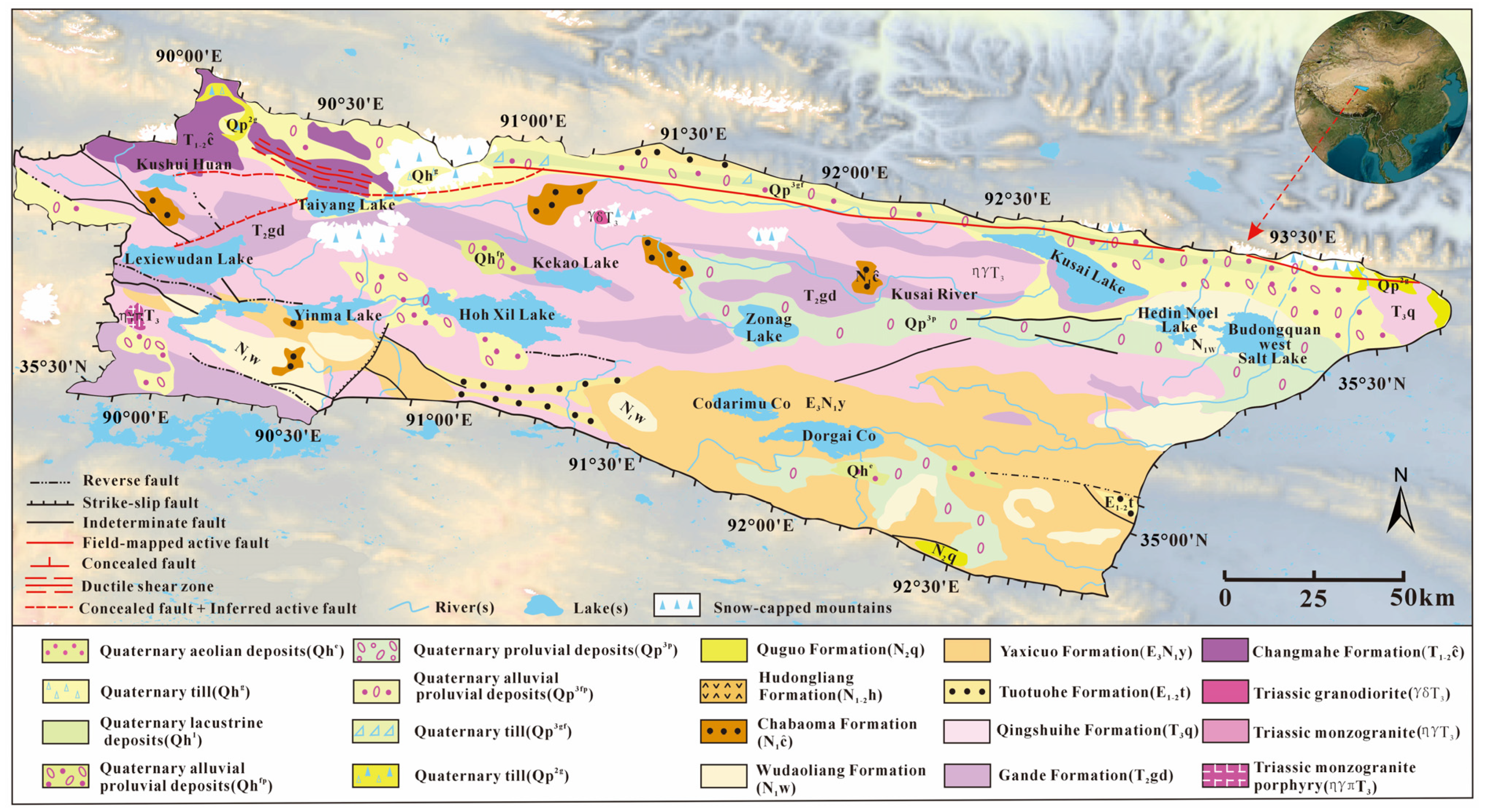
The HXB occupies the endorheic zone within the plateau interior, bounded by the Tanggula Mountains to the south and Kunlun Mountains to the north, extending to the QTP westward and the Qinghai–Tibet Highway eastward, with elevations consistently exceeding 4000 m [45], forming a critical basin corridor and material transfer pathway between the Kunlun and Tanggula orogenic belts (Figure 1). Geologically and structurally, the HXB is controlled by the southern Kunlun suture zone and its associated thrust–strike–slip fault systems [46], exhibiting an overall E-W orientation with a basement composed of Paleozoic pre-crystalline rocks and Mesozoic low-grade metamorphic sediments, filled predominantly by Mesozoic to Cenozoic continental clastic–evaporitic successions (Figure 2): the widespread Triassic Bayan Har Group (Changmahe Fm-T1-2c, Gande Fm-T2gd, Qingshuihe Fm-T3q) sandstones and slates are overlain by the Paleogene Tuotuohe Fm-E1-2t (sand, siltstone, and conglomerate) and Yaxi Co Fm-E3N1y (mudstone and sandstone intercalated with gray mudstone and gypsum beds, locally containing halite), succeeded by the Neogene Wudaoliang Fm-N1w, Chabomao Fm-N1c (trachyte, latite, volcanic breccia lava, and basalt–andesite), along with the Hudongliang Fm-N1-2h (rhyolite-dacite–latite–subrhyolite) and Quguo Fm-N2q (conglomerate–sandstone–mudstone), while Quaternary deposits comprise multiphase glacial till, glaciofluvial, eolian, lacustrine, and alluvial–proluvial cover sequences. Intense regional neotectonic activity features multidirectional superimposed fault systems that govern geomorphic evolution and basin depocenter migration. The Indosinian granitic plutons surrounding Bukadaban Peak to the north provide potential heat sources and conduits for deep hydrothermal-spring systems. These plutons consist predominantly of coarse-grained biotite granite and porphyritic biotite-tourmaline granite, with localized porphyritic monzogranite and plagiogranite. They establish the petrological conditions for deep-sourced supply and subsequent leaching-mobilization of elements including B, Li, Rb, and Cs [47,48,49,50]. Consequently, the extensive occurrence of evaporites combined with multiple volcanic-tectonic thermal episodes establishes the material basis for regional solute supply and endmember differentiation [51].
The HXB exhibits an alpine desert to semi-arid climate with mean annual temperatures below −4 °C and annual precipitation around 300 mm, heavily concentrated during May-September [52]. Temperature is a critical factor controlling brine enrichment through its influence on evaporation rates and ice-melt dynamics. Observational records demonstrate pronounced warming trends across the region over recent decades: mean annual temperatures have increased by approximately 0.3–0.4 °C per decade since the 1980s, with more pronounced warming during winter months [52]. This warming has accelerated glacial retreat, extended the ice-free season, and intensified evaporation, collectively driving hydrochemical evolution and brine concentration processes in regional salt lakes [53,54]. Widespread permafrost, pronounced cryogenic weathering, and evaporation rates exceeding precipitation collectively determine the endorheic water balance characterized by strong recharge–evaporation coupling [53]. Governed by orographic precipitation effects and station temporal patterns, regional precipitation exhibits a southeast–northwest spatial gradient, with vegetation types transitioning correspondingly from alpine meadows through alpine steppes to alpine periglacial vegetation [54]. Hydrologically, the majority are endorheic-closed lakes primarily recharged by glacial and snow meltwater with supplementary spring inputs, while a minority constitute inter-fluvial lakes; representative members of the northern lake complex include Taiyang Lake (TYL), Lexiewudan Lake (LXWDL), Yinma Lake (YML), Hoh Xil Lake (HXL), Zhuonai Lake (ZNL), and Kusai Lake (KSL), while the Hongshui River (HSR) in the upper Nalenggele River (NLGLR) system traverses the Kunlun Mountains to discharge into the Qaidam Basin (QB), exemplifying trans-tectonic drainage connectivity and material exchange pathways [55,56].
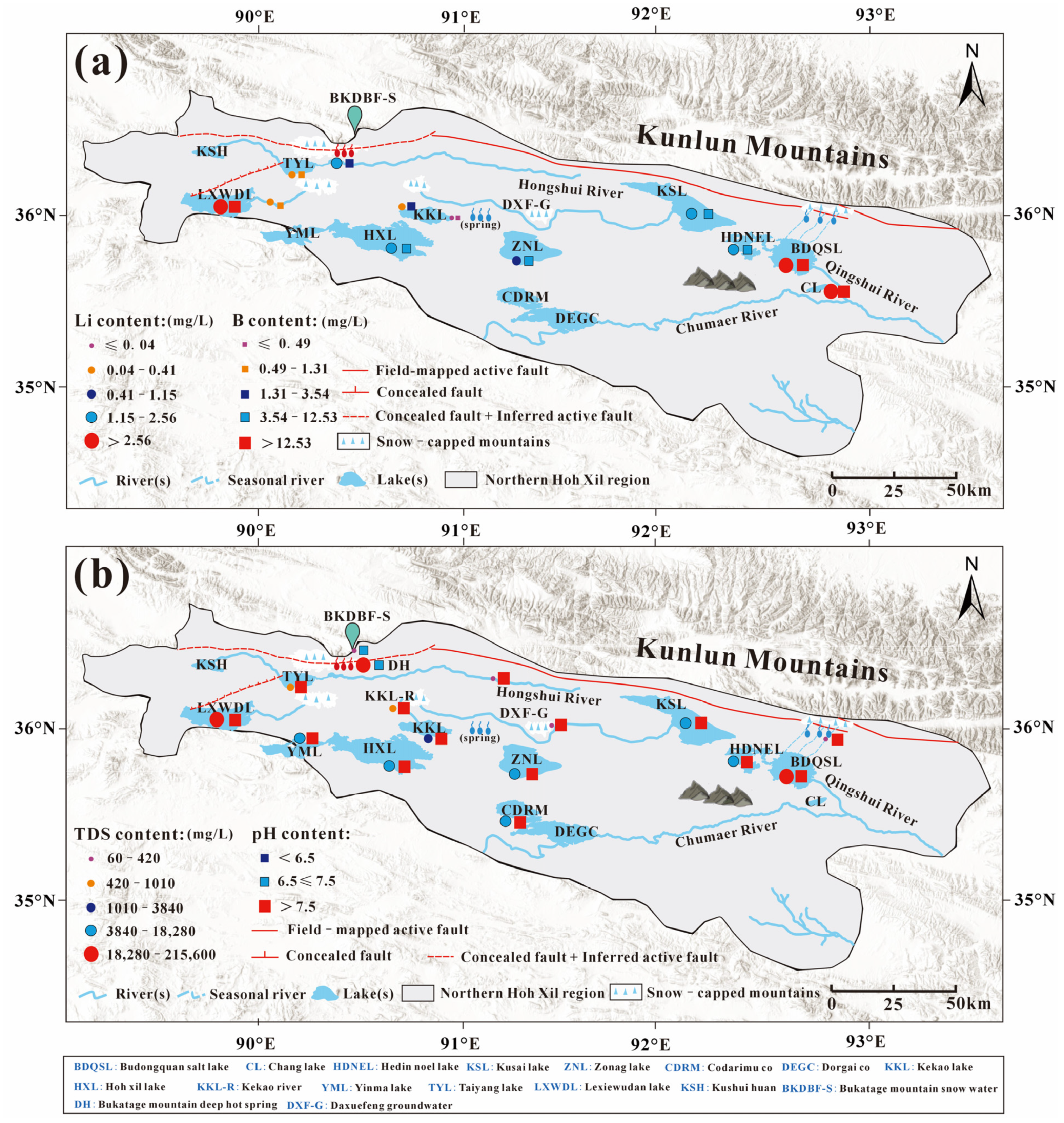
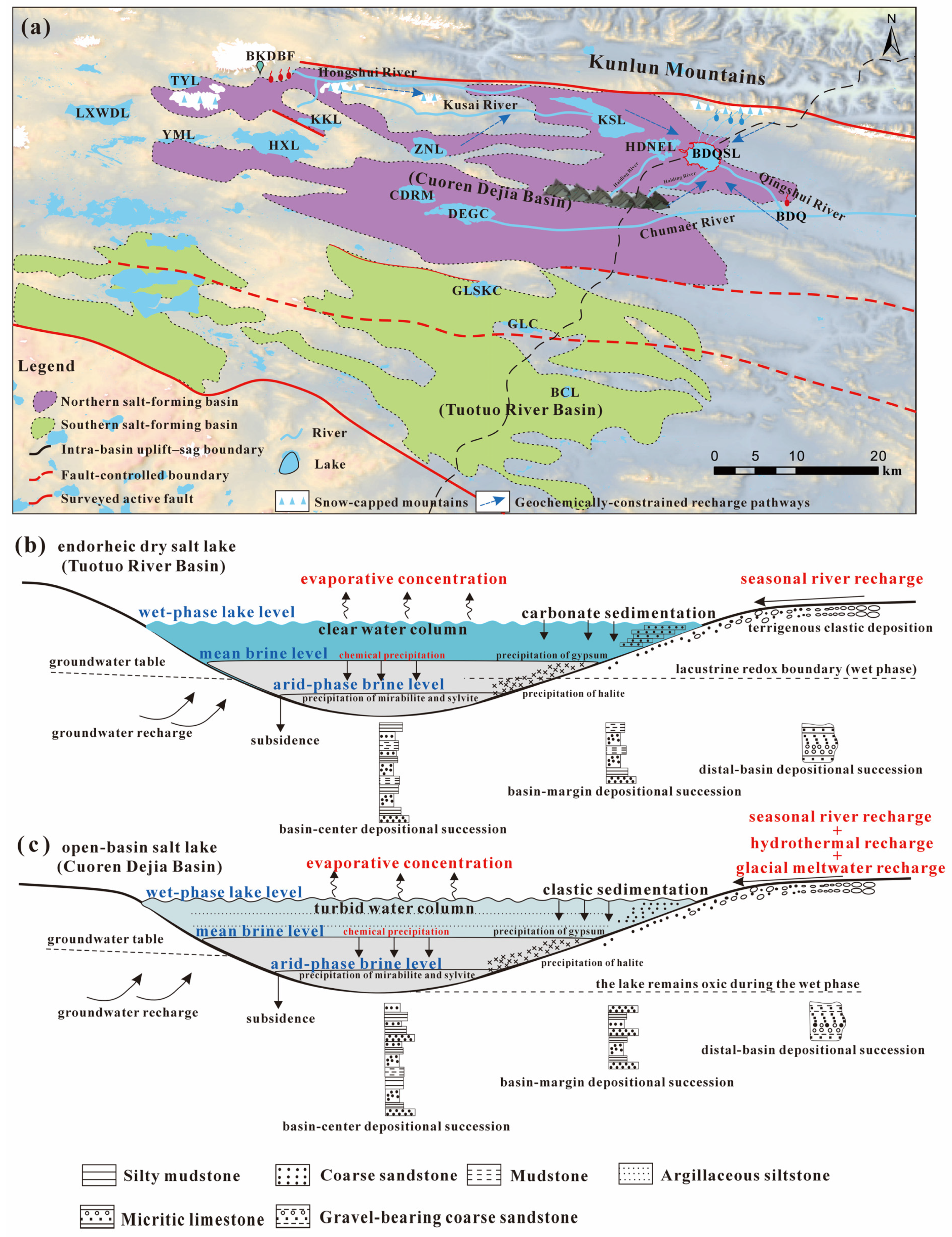
The salt lake west of Budongquan (BDQSL) (abbreviated as “Salt Lake” in other literature), which serves as the study area of this research, is situated in the interior of HXB and represents a subordinate closed depression within the Cenozoic intermontane rift system of the southern Kunlun Mountains, bounded by the Bukaletage Mountain of the southern Kunlun suture zone to the north and the Tanggula Mountains to the south (Figure 1 and Figure 2). The peripheral mountains of the lake basin exhibit typical periglacial alpine erosion features, characterized by year-round snow cover on summits, extensive permafrost distribution, and intensive cryogenic weathering. The basin interior comprises a plateau-type broad valley lacustrine plain with expansive and gentle topography. The terrain gradient is approximately 2‰, with abundant permafrost marshes and thermokarst ponds distributed along the lake margins. Regarding spatial connectivity, the lake basin borders Heiding Nuoer Lake (HDNEL) to the west and is separated from the Qingshui River, a tributary of the Chumaer River (the northern headwater of the Yangtze River), by a low-relief watershed divide to the east, positioning it at a critical transition zone between endorheic and exorheic drainage systems with heightened sensitivity to water redistribution and potential spillover events. More importantly, prior to 2011, ZNL, HDNEL, and the BDQSL functioned as four relatively isolated endorheic lakes, each maintaining independent hydrological regimes with recharge dominated by precipitation and glacial meltwater and discharge primarily through surface evaporation, lacking stable hydraulic connectivity among the lakes. Following the September 2011 outburst flood from southeastern ZNL and subsequent channel reorganization, the four lakes became hydraulically connected in a cascading system, converting the salt lake into the terminal lake of the drainage network with sustained expansion over the following years, as evidenced by its surface area increasing from 45.89 km2 in 2011 to 195.74 km2 by March 2019 (exceeding a 4-fold expansion), while the corresponding catchment area expanded from 1419.01 km2 to encompass the entire 8728.78 km2 watershed (representing over a 6-fold increase) (Figure 1c). As a result, the geometric configuration and hydrological balance of the lake basin underwent fundamental reorganization, enabling efficient downstream propagation of upstream water surpluses, seasonal ice–snow meltwater pulses, and extreme runoff events through the drainage network to the terminal basin, thereby altering the spatial distribution of endmember mixing and evaporative fluxes while establishing new boundary conditions and dynamic settings for subsequent evaporative concentration, mineral precipitation, and the migration–enrichment processes of critical elements including B and Li. This evolutionary framework provides the regional context for subsequent discussions on hydrochemical facies, stable isotopic signatures, and source–transport–sink mechanisms.

3. Sampling Strategy and Analytical Methods

Field sampling campaigns were conducted twice at the BDQSL in July and September 2024. For spatial sampling distribution, 69 surface water sampling sites were established across the salt lake along with 2 dynamic monitoring stations (Figure 1c, Table A1 and Table A3), providing uniform coverage of the entire lake basin; water samples were collected at approximately 30 cm depth below the surface at each site to characterize horizontal hydrochemical variability [57]. Given the potential for vertical stratification in the lake water, 14 stations were selected at the lake center and representative sections for depth-profiled sampling. At each station, paired water samples were collected using a weighted Van Dorn sampler: surface layer samples at 0.5 m depth and near-bottom layer samples at water depths ranging from 1.0 to 1.5 m (depending on local bathymetry, with the sampler positioned approximately 10–15 cm above the sediment–water interface to avoid sediment disturbance). Vertical profiling measurements of temperature, pH, electrical conductivity, and dissolved oxygen were conducted at 0.2 m intervals using a YSI multiparameter probe (model Pro2030; Xylem Inc., Yellow Springs, OH, USA) to characterize water column structure. All depth-stratified samples were collected within a 2 h window at each station to minimize temporal variations, and sampling locations were recorded with GPS coordinates to enable precise repositioning during subsequent campaigns (Table A1). Samples were collected using pre-cleaned polyethylene bottles that were triple-rinsed with sample water prior to collection; all water samples underwent field filtration through 0.45 μm cellulose acetate membranes and were allocated into two container sets: one acidified with ultrapure nitric acid to pH < 2 for cation and trace element analyses, and another preserved without additives for anion and isotope analyses. All samples were labeled, sealed, and preserved under refrigerated and dark conditions; in situ measurements of water temperature, pH, electrical conductivity, and other fundamental parameters were recorded using portable multi-parameter probes, along with precise documentation of geographic coordinates and environmental characteristics at each sampling location [58,59,60]. Field observations of surficial mineral precipitates and evaporite occurrences were documented at accessible shoreline locations during sampling campaigns, including visual identification of light-colored evaporite crusts and crystalline deposits. However, systematic sediment coring, sampling, or laboratory mineralogical analyses (such as X-ray diffraction or scanning electron microscopy) were not undertaken in this study. Regional sediment mineralogy, evaporite assemblages, and stratigraphic architecture presented in subsequent discussions are synthesized from published geological investigations [25,35,44,47,48,51] rather than original analytical results from this research. Furthermore, to strengthen regional comparisons and endmember identification, this study systematically compiled and incorporated previously published datasets comprising 13 lake samples, 5 river water samples, 3 groundwater samples, and 3 snowmelt/thermal spring samples (see Table A4).
Analytical procedures followed standardized protocols established by the Qinghai Institute of Salt Lakes, Chinese Academy of Sciences, ensuring data consistency and comparability. Major anions (SO42−, Cl, HCO3, etc.) were analyzed using ion chromatography (Dionex DX-120; Dionex Corporation, Sunnyvale, CA, USA) with detection limits of 0.02 mg/L for Cl, 0.05 mg/L for SO42−, and 0.1 mg/L for HCO3; analytical precision was better than ±2% for concentrations > 10 mg/L and ±5% for concentrations < 10 mg/L. Cations (Na+, K+, Ca2+, Mg2+) and trace elements (Li, B) were determined via ICP-AES (Thermo iCAP 6300) with detection limits of 0.01 mg/L for Na+, 0.02 mg/L for K+, 0.005 mg/L for Ca2+ and Mg2+, 0.001 mg/L for Li, and 0.005 mg/L for B; measurement precision was ±3% for major cations and ±5% for trace elements at concentrations exceeding 10 times the detection limits. Boron concentrations were expressed as B2O3 equivalents, and CO32− and HCO3 were quantified through titration methods with precision of ±0.5% [61,62,63]. Stable hydrogen and oxygen isotopes (δD, δ18O) were measured using a Picarro L2130i cavity ring-down spectrometer, achieving analytical precisions better than ±1‰ for δD and ±0.1‰ for δ18O relative to Vienna Standard Mean Ocean Water (VSMOW). Each water sample underwent six consecutive injections, with the first three injections discarded to eliminate memory effects from previous samples, and the final three injections averaged to obtain the reported isotope values. This protocol effectively prevents cross-contamination between samples, as demonstrated by consistent results from replicate standards analyzed throughout each analytical sequence. To further minimize potential carryover effects, samples were analyzed in order of increasing salinity where possible, and the analytical system was flushed with three injections of ultra-pure deionized water between samples of significantly different compositions. Quality control included analysis of three laboratory reference waters (spanning the natural range of δD and δ18O values) after every tenth sample to monitor instrumental drift and verify the absence of memory effects. The standard deviation of replicate measurements was consistently within ±0.8‰ for δD and ±0.08‰ for δ18O, confirming the reliability of the analytical protocol and the absence of systematic contamination between consecutive samples. Isotopic analyses incorporated δD–δ18O data from various water bodies within the basin to calculate deuterium excess (d-excess = δD − 8 × δ18O) for assessing evaporation history and moisture sources [64,65]. Following uniform unit conversions and outlier screening, the hydrochemical and isotopic datasets were processed for statistical analysis and visualization; AquaChem (version 2014.2; Schlumberger Water Services, Waterloo, ON, Canada) and similar software were employed to generate Piper trilinear diagrams and ionic relationship plots, while Gibbs diagrams and diagnostic ion ratios were utilized to identify dominant hydrochemical processes, with systematic comparisons and mechanistic interpretations conducted in the context of existing regional studies [66].

4. Results

4.1. Water Chemistry of Lake Water and Spatial–Vertical Variations

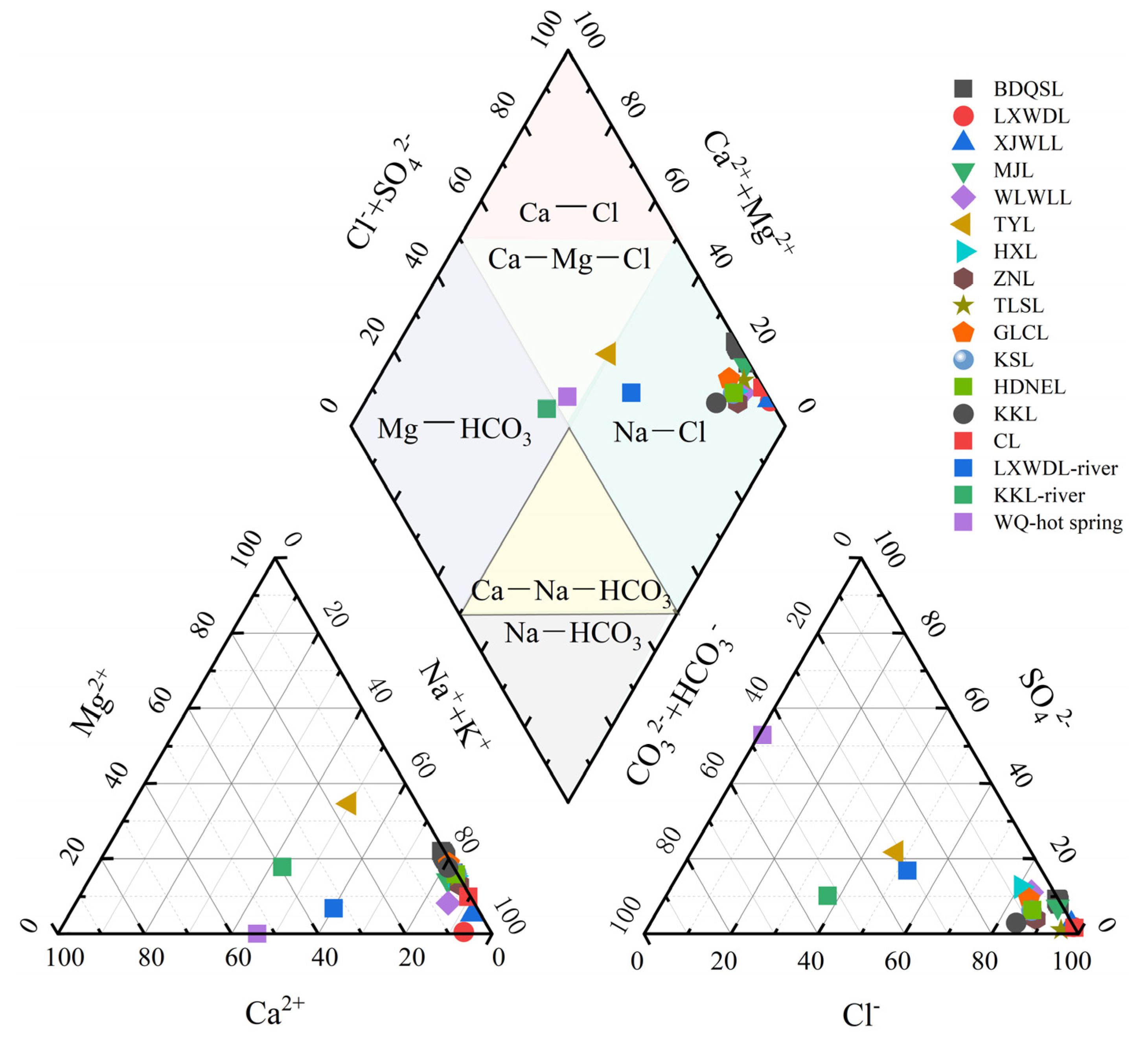
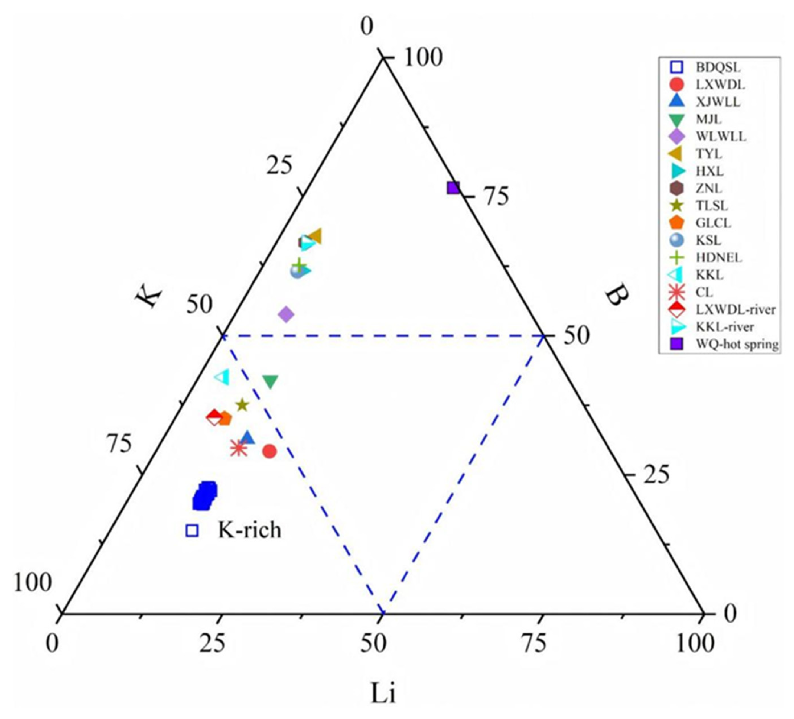
The BDQSL water body displays pronounced brine properties, characterized by low overall transparency and a faint yellowish-green coloration. Field-measured pH values ranged from 7.79 to 8.26 (mean ~8.1), indicating weakly alkaline conditions; water temperatures during summer sampling ranged from approximately 15 to 18 °C. Surface water density ranged from 1.13 to 1.15 g cm−3, substantially exceeding that of freshwater, indicative of exceptionally high dissolved solids content. Total dissolved solids (TDS) concentrations ranged from 192,700 to 220,700 mg/L, with a mean of approximately 210,000 mg/L, characteristic of typical hypersaline brine lakes (substantially exceeding the 50,000 mg/L threshold for saline lakes) (Table A1 and Table A2). The major ionic composition is illustrated in the Piper diagram (Figure 3), while relative abundances of K, B, and Li are depicted in the K-B-Li ternary diagram (Figure 4). The BDQSL brine is characterized by pronounced Na+ and Cl enrichment, definitively classifying its hydrochemical facies as Na-Cl type.
While the hydrochemical facies remains uniform throughout the lake, spatial variations in salinity and ionic concentrations are evident (Figure 3). Statistical analysis reveals relatively lower TDS values along the western and northern basin margins, with marked increases toward the lake center and southeastern shoal zones: specifically, site BDQSL-44, situated near the spring recharge zone on the northwestern shore, exhibits the lowest concentration across the lake (~192.7 g/L), whereas site BDQSL-15 in the southeastern shallow zone, subject to enhanced evaporation, reaches 220.7 g/L. Generally, salinity exhibits a progressive increase from primary recharge zones toward the lake center and downwind sectors. Correspondingly, constituents including Mg2+ and SO42− demonstrate marginally lower concentrations near inflow/recharge zones, progressively increasing toward the basin interior, though variations typically remain within 10%. Notably, Cl and Na+ concentrations in water samples proximal to the Budongquan outlet along the northern shore showed no significant reduction, remaining comparable to central lake values, indicating that the spring discharge itself represents a high-salinity endmember, critically attenuating localized dilution effects. Comparative analysis of surface and near-bottom samples from 14 vertical profiling stations demonstrates high vertical homogeneity in the water column.
Comparative analysis of surface and near-bottom samples across 14 vertical profiling stations demonstrates pronounced vertical homogeneity throughout the water column (Table A2). Vertical gradients in principal physicochemical parameters remain below 2% at the majority of stations: specifically, the central station exhibits surface and bottom TDS concentrations of 214.6 and 217.2 g/L, respectively, with uniform density values of 1.142 g cm−3 and pH values of 8.18 and 8.25, respectively, representing statistically non-significant variations; analogously, western stations demonstrate Na+ concentrations of approximately 70 g/L and Cl concentrations of 118 g/L at both 0.5 m and >1 m depths, with variations confined within instrumental precision thresholds (Table A1). Marginal salinity gradients manifest at limited stations: near-bottom salinity and density periodically exceed surface measurements by 1–2%, accompanied by pH depressions of 0.05–0.1 units. These observations potentially reflect incipient density stratification within the hypersaline water mass coupled with ephemeral thermal inversions induced by nocturnal cooling [67,68,69]; comprehensively, persistent wind-driven stress and convective circulation preclude the establishment of stable vertical haline stratification [70,71,72]. The pronounced vertical homogeneity in BDQSL can be attributed to three synergistic mechanisms operating within the high-altitude lacustrine environment: (1) intense and persistent wind stress characteristic of the Hoh Xil Basin, where strong prevailing winds (average wind speeds exceeding 4–6 m/s) generate continuous turbulent mixing throughout the water column; (2) shallow water depth (typically 1.0–1.5 m in most sampling locations), which enables wind-induced currents to reach the lake bottom and prevent density-driven stratification; and (3) strong convective overturning driven by extreme diurnal temperature variations in the plateau environment, where intense daytime solar heating followed by rapid nocturnal cooling creates density instabilities that promote vertical mixing. These combined processes maintain well-mixed conditions despite the high salinity, effectively homogenizing dissolved constituents including B, Li, and major ions across depth profiles.

4.2. Ionic Relationships and Mineral Saturation

Major ionic equivalent ratios exhibit consistent stability throughout the system. Equivalent concentrations of (Na+ + K+) and Cl approximate unity, with the preponderance of samples positioned on or marginally below the 1:1 reference line (Figure 5a), reflecting slight Cl excess; the equivalent difference Δ1= Cl − (Na+ + K+) ranges from 5 to 10%. This characteristic maintains spatial uniformity: samples from both the northwestern spring recharge zone and southeastern evaporative shoal zone display comparable Δ1 magnitudes, without systematic deviation. Vertically, surface and near-bottom sample pairs from 14 stations demonstrate virtually coincident (Na+ + K+)–Cl relationships, with inter-layer variations predominantly <2% (Table A1), indicating comprehensive water column mixing and stable ionic conservation throughout the vertical profile. Alkaline earth cation–anion balance likewise exhibits systematic stoichiometric relationships. (Ca2+ + Mg2+) systematically demonstrates depletion relative to (HCO3 + SO42−) (Figure 5), with samples consistently plotting below the 1:1 reference line, yielding a mean equivalent difference Δ2 = (HCO3 + SO42−) − (Ca2+ + Mg2+) ≈ 8 meq/L. This deviation maintains comparable magnitudes across distinct hydrochemical zones (littoral recharge zone, central basin, evaporative shoals), with spatial variability typically ≤10%; vertical sample pairs exhibit essentially uniform Δ2 values (variations predominantly <2%). Correspondingly, Mg2+ concentrations remain elevated throughout the entire lake system (Table A1), without localized anomalous zones of significant depletion.
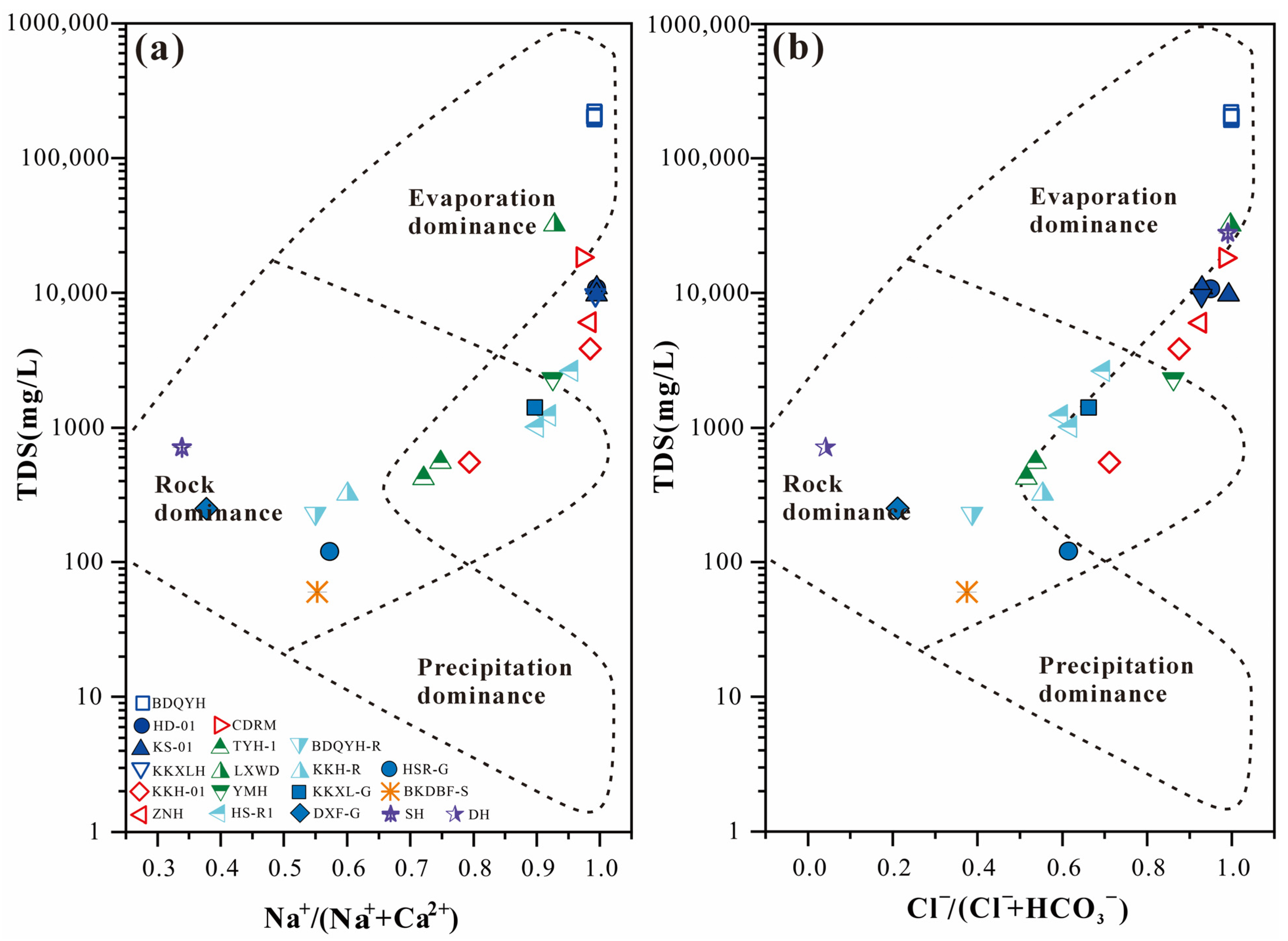
Mineral saturation indices and solubility constraints corroborate the observed stoichiometric relationships. Given lake water TDS concentrations of 192.7~220.7 g/L and densities of 1.13~1.15 g/cm3, samples remain below the NaCl solubility threshold of approximately 26% by mass (≈260 g/L); field observations correspondingly reveal sporadic light-colored precipitates within lacustrine depositional environments. Integrated graphical analysis reveals sample clustering within the high TDS, elevated Na/(Na + Ca), and high Cl/(Cl + HCO3) domain of the Gibbs diagram (Figure 6), establishing distinct separation from reference waters including riverine and spring samples. Collectively, ionic stoichiometric relationships demonstrate minor, coherent variations across both horizontal and vertical dimensions, with salinity ranges and graphical positioning mutually validating the prevailing ionic equilibrium characteristics and saturation states of the water mass.

5. Discussion

5.1. Enrichment and Spatial Heterogeneity of Major Trace Elements in the Brine of BDQSL

The brines from the BDQSL demonstrate exceptionally high mineralization (TDS ~200 g/L), exhibiting hydrochemical characteristics typical of chloride–sulfate waters [1,2]. Na+ and Cl constitute the predominant ionic species (cumulative mass fraction > 90%), with subordinate Mg2+ and SO42− concentrations; K+ demonstrates relative enrichment while Ca2+ remains depleted, characterizing these brines as Na-Cl dominated with secondary Mg2+ and SO42− enrichment (Figure 3) [3,69]. Concurrently, trace elements B and Li exhibit pronounced enrichment in the brines, attaining concentrations of several tens of mg/L, substantially exceeding background concentrations in surface runoff or glacial meltwater; their spatial distributions display analogous variation patterns, indicating coupled enrichment and migration mechanisms [7,8]. Collectively, major ionic constituents and B, Li concentrations in BDQSL brines exhibit predominantly spatial homogeneity, with only moderate gradient variations.
Major ionic concentrations (Na+, Cl, Mg2+, SO42−) across different regions maintain overall similarity, though subtle variations persist among sampling locations (Figure 5, Table A1). The Cl and Na+ sustain maximum concentrations lake-wide, ranging from 108,700~122,200 mg/L and 58,900~70,000 mg/L, respectively, with spatial variability constrained within 10%. The Mg2+ and SO42− distributions exhibit minor fluctuations, ranging from 6848~9550 mg/L and 13,010~16,020 mg/L, respectively; localized SO42− depletion at specific sites generates a subtle declining SO42−/Cl ratio gradient across the lake basin. These anionic ratio variations potentially reflect localized precipitation processes or dilution effects from freshwater inputs. Notably, the catastrophic drainage from ZNL outburst contributed substantial volumes to this salt lake system, inducing measurable freshwater dilution. Consequently, regions proximal to allochthonous recharge exhibit marginally reduced brine mineralization and major ionic concentrations, whereas distal sectors maintain hypersaline conditions. Notwithstanding these spatial gradients, ionic composition ratios across sampling locations demonstrate minimal variance, indicating substantial brine homogenization while maintaining consistent overall hydrochemical signatures [12,17,73,74,75].
The B and Li concentrations display coupled spatial variability within BDQSL. To evaluate the enrichment status of these elements, we employ regional background waters as the primary reference framework, specifically comparing BDQSL brine concentrations against inflowing rivers, shallow groundwater, and adjacent salt lake systems documented in this study and previous investigations (Table A3). The K-B-Li ternary diagram (Figure 4) reveals systematic displacement of all brine samples toward the K apex, indicating that while B and Li show absolute enrichment in BDQSL brines, they remain limited relative to K, directly attributable to the compositional characteristics of thermally derived solute inputs. The measured concentrations of B (45–51 mg/L) and Li (50–54 mg/L) in BDQSL brines represent substantial enrichment relative to regional background waters. Specifically, tributary rivers feeding the basin contain B concentrations of only 1.3–2.4 mg/L and Li concentrations of 0.2–0.4 mg/L, while shallow groundwater exhibits B concentrations of 0.5–1.0 mg/L and Li concentrations of 0.04–0.2 mg/L (Table A3). This indicates enrichment factors of approximately 20–100 times for B and 125–270 times for Li relative to inflowing fresh waters, demonstrating the effectiveness of combined hydrothermal input and evaporative concentration mechanisms. The concentrations show slight spatial variation, with marginally higher values near groundwater-recharge zones, but remain broadly uniform overall. The B-Li distribution pattern (Figure 7) delineates preferential enrichment within zones influenced by groundwater spring discharge and allochthonous lacustrine inputs, with remaining sectors exhibiting marginally attenuated yet comparable concentrations. This spatial enrichment pattern becomes clearer through direct comparison with adjacent lacustrine systems. The upstream Zonag Lake (ZNL) contains B concentrations of 9–11 mg/L and Li concentrations of 1.2–2.1 mg/L, while Kusai Lake (KSL) exhibits B concentrations of 11–12 mg/L and Li concentrations of 2.1–2.6 mg/L (Table A3). These brackish systems demonstrate systematically lower element concentrations than BDQSL, with enrichment ratios of approximately 4–5 times, reflecting BDQSL’s role as a hydrologically closed terminal basin that concentrates solutes through persistent evaporative processes coupled with direct geothermal inputs [23,24,25,26,27]. Specifically, eastern HXB salt lakes systematically exhibit higher mean B and Li concentrations than western counterparts. B concentrations of 40–80 mg/L have been documented in enriched systems such as Lexiewudan Lake (LSWDL) [42], which are comparable to BDQSL values, contrasting markedly with tributary springs and rivers containing merely several to twenty mg/L. These observations demonstrate substantial B and Li enrichment in regional salt lake brines relative to their source waters, establishing salt lake-centered enrichment domains through evaporative concentration mechanisms [29,76]. Critically, the B persists predominantly as undissociated boric acid under the neutral–alkaline conditions characteristic of salt lake brines, maintaining exceptional solubility; lithium remains in aqueous phase as dissolved ions, exhibiting conservative geochemical behavior analogous to Na+ and Cl, resisting mineral sequestration during concentration while maintaining coherent migration with the brine phase. Consequently, B and Li demonstrate negligible precipitation or fractionation within salt lake brines, maintaining invariant concentration ratios throughout the basin with synchronized concentration fluctuations [32,76,77,78].
Collectively, the BDQSL brine chemistry exhibits relative spatial homogeneity characterized by gradational concentration gradients, without manifesting distinct north–south geochemical zonation. While marginal concentration variations exist between proximal and distal recharge zones (exemplified by minor SO42− depletion and subtle B, Li enhancement), these represent continuous gradational transitions rather than discrete geochemical compartmentalization. Hydrochemical facies remain invariant across all sampling locations, with trace element enrichment zones exhibiting no strict spatial confinement to specific lake sectors. Consequently, BDQSL demonstrably lacks definitive meridional geochemical zonation, with brine compositional architecture characterized by coherent enrichment patterns and gradational spatial transitions. These findings accord with the lake’s documented rapid expansion following recent allochthonous inputs and subsequent comprehensive homogenization processes [77,79].

5.2. Sources and Enrichment Processes of Dissolved B-Li in Brine from the BDQSL

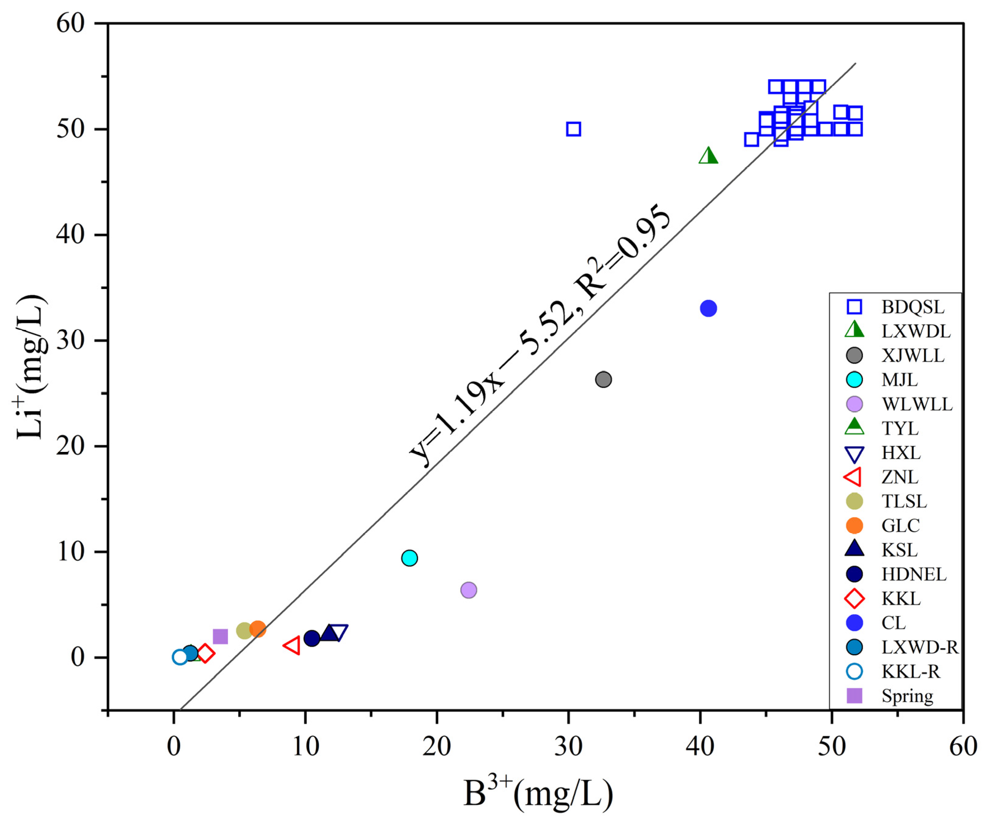
Extensive research demonstrates that enrichment and accumulation of critical elements including potassium, boron, lithium, rubidium, and cesium within terminal salt lake systems across the QTP are predominantly governed by source–transport–sink processes [1,9,24,31,33,34,78]. The coupled enrichment of B and Li within salt lake brines represents a particularly significant phenomenon. Within plateau salt lake systems, B and Li demonstrate intimate geochemical relationships, exhibiting systematic positive correlations with increasing brine salinity. Regional investigations reveal that Hoh Xil and adjacent salt lake systems frequently develop anomalous zones characterized by elevated B and Li concentrations, demonstrating reciprocal variations and synergistic enrichment patterns [10,39]. Consequently, it has been postulated that B and Li within plateau salt lakes share analogous provenance, migration pathways, and enrichment environments [51]. This inference receives corroboration through the present investigation: B and Li concentrations across BDQSL sampling locations exhibit near-linear correlation (R2 = 0.95), indicating derivation from identical processes or concurrent incorporation within unified hydrological flows (Figure 8). Specifically, water samples from the northern Budongquan recharge zone exhibit concurrent B and Li depletion, suggesting relative dilution from spring water inputs; conversely, samples from the central evaporative zone demonstrate synchronized B and Li enhancement, indicating evaporative concentration-driven enrichment within residual brines [43,73]. Evidently, B and Li demonstrate highly coupled behavior within BDQSL across both source recharge and intralacustrine processes.
Three mechanistic explanations for B-Li enrichment sources and processes encompass: (1) Terrestrial weathering contributions: Basin-hosted granitic and gneissic lithologies contain elevated Li and Rb concentrations, with protracted chemical weathering facilitating element mobilization into groundwater and surface runoff systems [44,45,79]. Ancient evaporitic boron minerals and lithium-enriched clay minerals in basin stratigraphy progressively release B and Li through water–rock interactions [46,47]. Regional spring waters exhibit B and Li concentrations significantly exceeding atmospheric precipitation and riverine background values, substantiating substantial trace element contributions from lithological weathering processes [50]. (2) Hydrothermal–geothermal contributions: The Budongquan spring complex along the northern lake margin represents a high-temperature geothermal discharge zone where thermal waters undergo deep-seated high-temperature water–rock interactions, acquiring substantial Li, B, Rb, and Cs enrichments that exceed conventional groundwater by multiple orders of magnitude [56,57]. Thermal springs near Bukadaban Peak in northern Hoh Xil exhibit concentrations substantially exceeding shallow groundwater values, indicating deep magmatic–hydrothermal leaching of plutonic rocks and Paleozoic evaporite sequences [7]. Hydrogen and oxygen isotopic analyses corroborate that ascending thermal waters undergo meteoric mixing before convergence with surface runoff into lacustrine systems [65,73,80]. Thermal spring discharge represents the predominant lithium source for Tibetan Plateau salt lake brines, with the spring belt along the northern Kunlun Mountain front constituting the primary B-Li enrichment source zone for BDQSL. (3) Evaporative concentration mechanisms: Under prevailing arid-cold climatic conditions, lacustrine evaporation substantially exceeds precipitation, progressively concentrating dissolved trace elements [68,77]. Given that Li+ and B3+ ions resist preferential incorporation into conventional evaporite mineral lattices, they preferentially partition into residual brines, achieving substantial concentration factors. Measured B concentrations of 40–60 mg/L and Li concentrations of 50–55 mg/L in BDQSL, exceeding riverine and shallow groundwater values by several orders of magnitude, directly manifest evaporative concentration effects [70]. Regional salt lakes demonstrate analogous patterns, with intensive evaporative concentration coupled with trace element exclusion from precipitating phases facilitating progressive rare metal enrichment and generating economic resource accumulations [4,72].
Collectively, elevated thermal spring inputs, extensive water–rock weathering processes, and persistent evaporative concentration synergistically generate substantial B and Li trace element resources within BDQSL. This integrated source–transport–sink mechanism positions BDQSL among the highest B and Li concentrations within northern Hoh Xil salt lakes, indicating substantial resource potential. Critically, recent climate warming-induced freshening trends have demonstrably impacted trace element concentrations. Observational evidence documents pronounced freshwater dilution across numerous northern Hoh Xil lakes. Enhanced glacial meltwater and precipitation inputs, while diluting lacustrine salinity, concurrently depress absolute B, Li, Rb, and Cs concentration maxima relative to historical hypersaline conditions. This dilution effect manifests within the study area—current trace element enrichment maxima in BDQSL brines potentially remain below values recorded during extreme drought conditions several decades ago. However, absent direct Rb and Cs concentration measurements in this investigation, detailed discussion remains beyond the current scope. Notably, climate change-induced dilution trends receive comprehensive examination in Section 5.3 through integrated hydrogen–oxygen isotopic analysis and regional climatic contextualization.

5.3. Evaporation and Hydrological Reorganization Freshening Effects: Evidence from H–O Isotopic Signatures at BDQSL

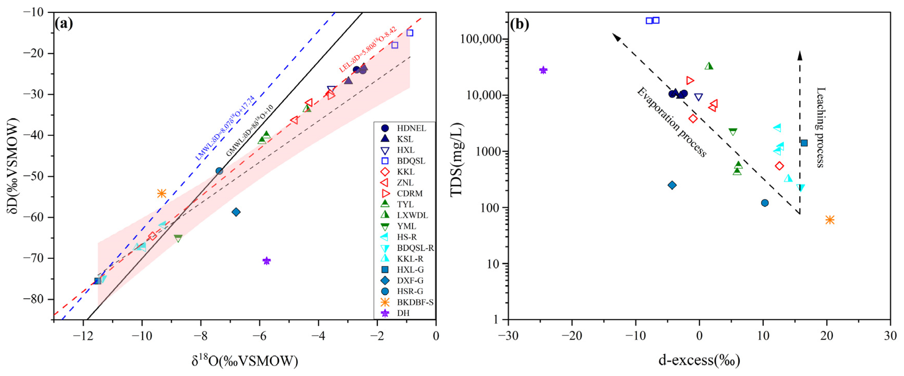
Plateau climate change has exerted profound influences on hydrological processes within the BDQSL watershed. Stable isotopic compositions (δD and δ18O) constitute robust tracers for investigating these impacts, elucidating lacustrine water source compositions and evaporative processes, thereby revealing hydrological budget dynamics [20,32,63]. The δ18O and δD values across diverse water types within the Hoh Xil salt lake basin (precipitation, glacial meltwater, riverine water, groundwater, lacustrine water) cluster proximal to the Local Meteoric Water Line (LMWL), demonstrating regional precipitation as the predominant recharge source (Figure 9) [33,59,64,65]. Hydrogen–oxygen isotopic analyses corroborate this interpretation: BDQSL samples exhibit minimal enrichment offset from the LMWL in δD-δ18O space (Figure 9a), confirming predominant derivation from local precipitation and cryospheric meltwater with negligible allochthonous moisture contributions [22,60]. Concurrently, the isotopic regression line (evaporation line) defining lake and tributary waters exhibits a substantially reduced slope relative to the regional meteoric water line, indicative of pronounced kinetic (non-equilibrium) evaporative fractionation [34,63,66]. Consequently, lacustrine evaporation generates heavy isotopic enrichment exceeding that of source waters. Indeed, the BDQSL samples systematically plot along evaporative trajectories below both global and local meteoric water lines, exhibiting isotopic compositions substantially enriched relative to recharge waters: maximum lacustrine δ18O values approach −1.4‰ (δD ≈ −18‰), markedly exceeding groundwater (δ18O ≈ −11.1‰) and glacial meltwater (δ18O ≈ −11.3‰) signatures [23,24,68]. Specifically, upstream ZNL exhibits mean δ18O values of −4.3‰ (δD ≈ −32‰), whereas downstream BDQSL demonstrates progressive enrichment to −1.4‰ (δD ≈ −18‰). Progressive isotopic enrichment from headwater ZNL to terminal BDQSL demonstrates intensified evaporative concentration downstream, with recharge waters incorporating progressively greater proportions of evaporatively evolved components [27,69]. This downstream isotopic enrichment trajectory parallels systematic salinity increases: ZNL maintains TDS values of several g/L, whereas terminal BDQSL attains hypersaline concentrations exceeding 200 g/L. The coherent hydrochemical and isotopic evolutionary patterns unequivocally demonstrate evaporative concentration as the fundamental control on lacustrine evolution within this watershed [73,74].
Deuterium excess parameters (d = δD − 8δ18O) enable quantitative assessment of evaporative modification intensity [32,65]. Typically, progressive evaporative intensity correlates with decreasing deuterium excess values, potentially reaching negative domains. Analytical results reveal BDQSL d-excess values of approximately −5‰, substantially depleted relative to tributary waters (+8‰) and groundwater (+10‰), identifying lacustrine waters as experiencing maximum evaporative modification within the regional hydrological system [29]. Concurrently, d-excess values demonstrate significant inverse correlation with TDS, whereby elevated salinities correspond to progressively depleted d-excess values (Figure 9b). This relationship, documented across diverse saline lake systems, constitutes diagnostic evidence for evaporative salt accumulation mechanisms. Consequently, contemporary salt accumulation within BDQSL demonstrably results from intensive evaporative concentration rather than lithological dissolution or alternative recharge mechanisms [34]. Specifically, lacustrine hydrological balance (precipitation and meltwater inputs versus evaporative losses) fundamentally governs salinity evolutionary trajectories: negative water balance promotes progressive salinization, whereas positive balance induces freshening trends [3,69].
Recent regional climatic transitions have initiated incipient freshening trends within BDQSL [52,53,70]. Since the 1980s, the QTP has exhibited pronounced warming and humidification trends, characterized by substantial temperature increases and enhanced annual precipitation across the HXB [54,55]. This climatic transition directly modulates lacustrine hydrological budgets: elevated temperatures accelerate alpine glacial ablation, synchronously augmenting precipitation and meltwater inputs, while enhanced active layer thaw depths provide sustained groundwater recharge; although evaporative intensity has concurrently increased, the net hydrological balance transitions from deficit to surplus conditions. Macroscopically, these processes manifest as systematic lake area expansion coupled with progressive salinity reduction. Remote sensing analyses document pronounced BDQSL expansion over the past decade (Figure 1c): relative to 2010 baselines, novel inundation zones manifest along basin margins, with western and northern shorelines prograding several hundred meters. This indicates sustained volumetric expansion over the decadal period, accompanied by measurable salinity dilution [3,62]. Systematic freshening trends across Hoh Xil salt lakes since the 1980s have been documented, accompanied by substantial reductions in hypersaline lake abundance [36]. For saline lake resource exploitation, these transitions present both opportunities and challenges: freshening potentially retards premature evaporite precipitation, extending brine residence times for Li, B, Rb, and Cs, facilitating resource accumulation; conversely, sustained dilution reduces extractable element concentrations, compromising direct recovery economics.
Notably, episodic inter-lacustrine hydrological connectivity events have exerted substantial impacts on BDQSL salinity [6,7]. Specifically, the 2011 ZNL outburst flood discharged substantial water volumes downstream, establishing hydrological connectivity among sequential basins, dramatically augmenting KSL and HDNEL volumes, with concomitant BDQSL level increases [16,60]. Observational data indicate post-flood salinity reductions of approximately 5% in BDQSL; despite subsequent evaporative recovery, pre-flood salinity levels remain unattained. This demonstrates that abrupt freshwater pulses during extreme events generate transient perturbations in terminal lake hydrochemistry. Nevertheless, climate-driven progressive modifications constitute the dominant long-term controls on saline lake evolutionary trajectories. Projecting forward, continued QTP warming and humidification will likely drive further BDQSL expansion and freshening, facilitating gradual transition from hypersaline to brackish conditions, with hydrochemical evolution away from contemporary chloride-dominated hypersaline characteristics toward lower-salinity transitional facies. These lacustrine evolutionary trajectories bear critical implications for regional hydro-ecological systems while necessitating strategic adaptations in saline lake resource exploitation protocols.

5.4. Salt Formation–Mineralization Model of Salt Lakes in the HXB

The middle to upper sections of the Oligocene Yaxicuo Group (Paleogene) in the Kekexili region constitute the primary host horizons for salt-bearing formations [47,48]. According to Gong et al. (2014), the region comprises two salt-bearing sub-basins: the Tuotuohe Basin in the south and the Cuorendejia Basin in the north, representing closed and open saline lake depositional systems, respectively [25]. These two salt-bearing formations exhibit distinct sedimentary characteristics: the Tuotuohe Basin’s salt-bearing sequence is predominantly yellowish-green with intercalated purple-red, gray-green, and gray-black layers, composed primarily of marl and mudstone with abundant gypsum and minor sandstone and siltstone, totaling approximately 1100 m in thickness; conversely, the Cuorendejia Basin’s salt-bearing sequence is characterized by uniform purple-red coloration without variegated layers, consisting of alternating purple-red mudstone, siltstone, and fine sandstone rich in gypsum, reaching 1400 m in thickness and notably lacking carbonate rocks [47,48,51]. This north–south differentiation reflects distinct paleolacustrine environments: the Tuotuohe Basin represents closed saline lake sedimentation, whereas the Cuorendejia Basin exhibits open saline lake deposition [71,73]. This geological context provides critical constraints for understanding the salt formation and mineralization model of BDQSL.
Ion ratio analysis further elucidates the solute provenance characteristics of BDQSL. In the Ca/Na–Mg/Na and Ca/Na–HCO3/Na bivariate diagrams (Figure 10), BDQSL brine samples plot distinctly away from carbonate and silicate weathering end-members, clustering near the evaporite dissolution end-member. This distribution pattern demonstrates that Ca2+, Mg2+, and HCO3 ions in the brines are not predominantly sourced from conventional carbonate or silicate weathering processes. By comparison, studies of Gasikule Salt Lake in the QB reveal significant positive correlations between Ca2+, Mg2+, and HCO3 concentrations, indicating carbonate dissolution as the dominant solute supply mechanism; however, the BDQSL samples deviate markedly from this trend, suggesting minimal contribution from carbonate weathering. Instead, the ionic composition of BDQSL brines more closely resembles a composite model involving evaporite dissolution combined with deep hydrothermal fluid input [11,35,36]. Research on Ca–Cl-type brines in the QB has confirmed that major ions in these waters derive from both the re-dissolution of ancient basin evaporites and potential mixing with deep magmatic–hydrothermal components. Therefore, ion ratio evidence supports that the salt-forming evolution of Budongquan Salt Lake brines is primarily controlled by the coupled processes of deep hydrothermal input and evaporite dissolution, with negligible contributions from carbonate or silicate weathering [73,76,78].
Based on these solute source constraints, the salt formation and mineralization model of BDQSL can be characterized as a “hydrothermal-evaporative composite mineralization” system [11,35]. According to the regional sedimentary–mineralization model, while BDQSL exhibits an overall open lacustrine basin configuration, it functions through dual mechanisms of hydrothermal input and evaporative concentration during mineralization (Figure 11). Deep hydrothermal fluids continuously deliver lithium- and boron-enriched mineralizing fluids through fault structures, providing endogenous supply of critical elements; simultaneously, intense evaporation under the cold, arid climate drives progressive concentration of salts and metallic elements in the lake waters [49,50]. The primary factors controlling this model include: (1) Structural control—the southern Kunlun suture zone and its associated thrust–strike–slip fault systems provide critical conduits for ascending deep hydrothermal fluids. The fault network comprises multidirectional superimposed structures that penetrate deep into the crust, establishing direct hydraulic connectivity between deep-seated geothermal reservoirs and surface discharge zones. Specifically, the north-dipping thrust faults and intersecting strike–slip faults create high-permeability pathways that channel thermal fluids from depth (potentially sourced from Indosinian granitic plutons at 5–10 km depth) to the surface spring complexes along the northern lake margin. The spatial distribution of thermal springs at BDQSL shows strong alignment with mapped fault traces, with spring discharge concentrated at fault intersections where enhanced fracture permeability facilitates focused fluid upwelling. This structural architecture is consistent with other hydrothermal systems in the Kunlun orogenic belt, where active fault zones serve as primary conduits for deep fluid migration [46,49]. The ongoing neotectonic activity maintains fault permeability and sustains long-term hydrothermal circulation, ensuring continuous delivery of B-Li-enriched fluids to the lacustrine system; (2) hydrological recharge—differentiated recharge patterns from seasonal rivers and perennial hot springs; (3) climatic evaporation—intense evaporative forcing under extremely arid conditions; (4) hydrothermal ore sources—continuous input of deep thermal waters enriched in B, Li, and other elements. During arid seasons, river discharge diminishes sharply and the lake relies primarily on deep-sourced waters from subsurface hot springs, forming high-salinity brines through evaporative concentration under semi-closed conditions; during relatively humid periods, external recharge intensifies, yet hydrothermal input continues to contribute mineralization. Field observations revealed extensively developed light-colored evaporite crusts across lacustrine margins, consistent with published investigations documenting widespread gypsum and mirabilite assemblages in lacustrine sediments, along with diverse mineral precipitates including anhydrite and bassanite near hot spring vents [25,35,44]. These mineralogical assemblages, documented through previous sedimentological and X-ray diffraction analyses, collectively support the hydrothermal–evaporative composite mineralization model proposed for this system.
Compared to other B-Li-enriched salt lakes in HXL, BDQSL exhibits distinctive characteristics in its mineralization environment and recharge mechanisms. Bucha Salt Lake is extremely small (approximately 0.3 km2 in area, only 0.2 m deep) with Mg-sulfate-type saline waters, and published mineralogical analyses documenting the presence of anhydrite, bassanite, and ankerite in its salt deposits [2,10] indicate close association with subsurface hydrothermal activity; Duoxiu Salt Lake is larger (approximately 4.0 km2, 0.5 m deep) with Mg-sulfate-type brines containing exceptionally high Li concentrations (often exceeding 8 mg/L) and numerous salt dissolution caves, primarily recharged by precipitation and runoff to form typical evaporative concentration deposits [2,10,39]. In contrast, BDQSL, situated adjacent to the perennially flowing Budongquan springs, exhibits Na-Cl-dominated hydrochemistry, and while its lithium and boron concentrations (45–54 mg/L) are comparable in magnitude to the aforementioned salt lakes, its mineralization mechanism is distinctly different. More importantly, the continuous hot spring recharge at BDQSL, combined with the basin’s potential evolutionary transition from open to semi-closed conditions, distinguishes its mineralization process significantly from simple evaporative concentration models [73,74,78]. In summary, while salt lakes throughout the HXB are generally enriched in rare elements such as Li and B, the BDQSL has developed a composite mineralization model emphasizing both hydrothermal enrichment and evaporative concentration due to intense endogenous hydrothermal delivery, its distinctive lacustrine evolutionary history, and evaporite dissolution processes, establishing its unique position within the regional salt lake resource framework [11,35,39,80].

6. Conclusions

Based on comprehensive hydrochemical and isotopic (δD-δ18O-d-excess) analyses of 131 samples encompassing BDQSL brines and regional lakes, thermal springs, precipitation, groundwater, snow, and meltwater across the HXB, the following principal conclusions emerge:
(1)
BDQSL brines demonstrate extreme hypersalinity (TDS 192.7–220.7 g/L), characterized by a Na-Cl hydrochemical field with substantial B and Li enrichment (45–51 mg/L and 50–54 mg/L, respectively). Spatial distribution patterns exhibit concurrent overall homogeneity with localized gradients, demonstrating progressive salinity increases from northwestern recharge zones toward southeastern evaporative sectors, yet lacking discrete geochemical zonation; vertical physicochemical parameters maintain remarkable consistency, indicating comprehensive water column mixing. This spatial architecture reflects water mass homogenization processes following rapid expansion triggered by the 2011 ZNL outburst flood event.
(2)
Dissolved B-Li within BDQSL brines derives from synergistic hydrothermal inputs, water–rock weathering, and evaporative concentration processes (R2 = 0.95), demonstrating coupled migration pathways characterized by unified sources, concurrent transport, and co-located accumulation. Predominant hydrothermal contributions differentiate this lake’s B-Li enrichment mechanisms from purely evaporative saline systems.
(3)
Climate change-driven hydrological budgets transition toward positive balance conditions; H-O isotopic compositions are plotted systematically below the Local Evaporation Line (LEL), with d-excess values substantially depleted relative to input endmembers and inversely correlated with TDS, confirming evaporative fractionation as the dominant process. Concurrently, upstream cascade connectivity and recent warming–humidification trends drive lake expansion and brine dilution, signaling potential long-term evolution toward brackish conditions with profound implications for regional B-Li resource accumulation patterns.
(4)
Within the HXB’s open playa lake context, BDQSL mineralization integrates coupled “hydrothermal-evaporative composite” and “brine concentration-enrichment” mechanisms: fault-channeled thermal springs provide sustained B-Li fluxes, while intensive lacustrine evaporation amplifies concentration within the broad, shallow basin geometry, synergistically generating B-Li-enriched brines. This composite mineralization mechanism distinctly contrasts with mono-genetic evaporative systems exemplified by Bucha and Duoxiu lakes, representing archetypal mineralization processes characteristic of hydrothermally active plateau interior settings.
In synthesis, BDQSL brines have systematically recorded evolutionary trajectories encompassing hydrological balance reorganization, endmember mixing regime adjustments, and evaporative concentration intensity variations since lacustrine cascade connectivity and regional warming–humidification intensification; their hydrochemical and isotopic signatures not only elucidate thermal spring recharge–evaporative concentration enrichment mechanisms but also provide process-constrained geochemical frameworks and targeted exploration vectors for critical resource (B, Li) mineralization throughout eastern Hoh Xil salt lake systems. The established hydrothermal–evaporative composite model enables identification of high-potential B-Li exploration targets in regional lake systems, while the documented climate-driven dilution trends provide critical constraints for optimal timing of resource extraction and adaptive management strategies under ongoing hydrological reorganization. This study has several limitations that warrant future investigation. The sampling campaigns were conducted during summer months (July and September 2024), potentially underrepresenting seasonal hydrochemical variability induced by winter ice cover, spring snowmelt, and autumn precipitation. The spatial sampling density, while providing comprehensive coverage, may not fully resolve fine-scale heterogeneities in near-shore zones where localized groundwater seepage or thermal spring inputs occur. Future research should implement year-round monitoring programs and higher-resolution spatial sampling to better constrain temporal variability and resource evolution patterns under accelerating climate change.

Author Contributions

G.H. and Y.H. collected samples, experiments, data analysis, and writing. Q.C. performed project design, discussion, and revision. Y.Y. helped with discussion, sample collection and writing. C.L. and J.Z. carried out the discussion, revision, and sample collection. All authors have read and agreed to the published version of the manuscript.

Funding

This study was supported by Qinghai Province “Kunlun Talents-High-end Innovative and Entrepreneurial talents” training top talent project (QHKLYC-GDCXCY-2023-165).

Data Availability Statement

The original contributions presented in this study are included in the article material. Further inquiries can be directed to the corresponding authors.

Conflicts of Interest

The authors declare no conflicts of interest.

Appendix A

Table A1. Chemical composition of lake-surface brine from the BDQSL, northern HXB.
Sample IDpHTDS
(mg/L)
K+
(mg/L)
Na+
(mg/L)
Ca2+
(mg/L)
Mg2+
(mg/L)
SO42−
(mg/L)
Cl
(mg/L)
B2O3
(mg/L)
Li+
(mg/L)
CO32−
(mg/L)
HCO3
(mg/L)
NO3
(mg/L)
BDQSL-018.05215.6174068,250482.1933115,620119,600154.354300.7238.1-
BDQSL-028.15211.5172068,250462908815,230116,100147.354306.5262.5-
BDQSL-038.26211.8174066,250502.2918515,530117,900157.854283.8230.2-
BDQSL-048.15210.9172067,500482.1920915,280116,100150.853295.9248.6-
BDQSL-058.25212.9172067,500482.1920915,410117,900154.353305.1261-
BDQSL-068.08215174069,500482.1920915,540117,900154.354291.6228.8-
BDQSL-078.14215.4176069,000462930715,480118,800150.852299245.717.4
BDQSL-088.18214.6172069,000482.1933115,530117,900150.854283.8224-
BDQSL-098.12215.4170070,000482.1918515,570117,900154.353283.3227.1-
BDQSL-108.07214.8174068,250502.2920915,720118,800154.353288.4231.8-
BDQSL-118.05217.4170070,000482.1933115,670119,600147.354311.1267.2-
BDQSL-128.21214.2172067,750502.2920915,570118,800150.853285.3231.7-
BDQSL-138.15215.7174069,000462933115,740118,800150.854292.8251.6-
BDQSL-148.12217178068,250482.1945315,920120,500154.354295.9251.7-
BDQSL-158.24220.7178070,000502.2955016,020122,200154.354302263.9-
BDQSL-168.5199.4169063,750483876814,080110,100155.951181.613764
BDQSL-178.53205.9170066,000479684815,720112,800155.952236179.664.5
BDQSL-188.42205.1169066,000492876315,560111,900148.651261.7231.267
BDQSL-197.8200.5164062,850453854514,280112,200152.351.5228.2200.351.8
BDQSL-207.84195.7163059,450457897114,280110,400166.851.5198.3163.551.8
BDQSL-217.79199160062,500442842614,320111,300148.649.6113.798.2151
BDQSL-227.84196163060,000439879914,240110,400166.850214.4173.553.9
BDQSL-237.85198.8163062,850436849414,450110,400152.350210.8176.251.6
BDQSL-247.87199.8164060,700428892814,450113,100152.350222187.651.8
BDQSL-257.86201.8163063,550442891714,490112,200155.951220169.651.7
BDQSL-267.87199.7163062,150446904014,570111,300152.351226.9186.251.3
BDQSL-277.83193.9159060,000436855614,240108,70097.9500332.492.1
BDQSL-287.81200.6161062,850453879014,160112,200155.951203.2152.651.9
BDQSL-297.78199156062,500432873914,740110,500152.349.6113.496.2850
BDQSL-307.86203163063,550450909814,490113,100148.650250.6219.8101.2
BDQSL-31-204.3163063,550450922114,860114,000152.351226.9186.252.9
BDQSL-32-200.2163062,150450873114,530112,200148.650216.4178.751
BDQSL-337.93202.8164065,000439879914,980111,30014551249.9209.649.9
BDQSL-347.84204.9164064,300436904614,940114,000148.651232.5188.750.7
BDQSL-357.86204.2166064,300439879914,360114,000148.649.5244.3207.150.6
BDQSL-367.88203.3164064,300446885614,360113,100159.550225.6178.551.8
BDQSL-377.84197.3163061,400428862214,320110,400152.350205.9177.651.9
BDQSL-387.83198.2163062,150436861714,360110,40014550230.321550.4
BDQSL-397.87199.9166062,150421905513,790112,200152.350232.5191.952.5
BDQSL-407.79201166062,150432910914,740112,200148.651.5247235.251.9
BDQSL-417.86201.6168062,150418893414,740113,100152.350244.3210.350.6
BDQSL-427.82199.9168062,150453872915,020111,300148.651233.8202.850.2
BDQSL-437.84200.2166061,400442879715,100112,200148.650245214.151.4
BDQSL-447.82192.7161058,900425843913,090109,600148.649246.3228.251.4
BDQSL-457.76198.1164062,150425868414,200110,400141.449263238.949
BDQSL-467.84198.6166061,400436861714,570111,300152.350245217.350.6
BDQSL-477.81203.6168063,550446879514,530114,000155.950233.1202.151.9
BDQSL-487.83202.6166063,550439867614,570113,10014550257.5236.452.3
BDQSL-497.82202.6160062,500450836015,230114,00014550.8146.2142.253
BDQSL-507.84202.1168062,850428905014,410113,100148.650250.6219.851.7
BDQSL-517.85198.8166063,550436855614,410109,600148.649.5228.9204.150.9
BDQSL-527.78199.8164063,550432849613,790111,300148.649.5228.2197.150.2
BDQSL-537.86206.6168065,700446916214,940114,000152.350267.324052.9
BDQSL-547.83200.8160062,500439885714,740112,200152.350.8121.598.152.3
BDQSL-557.83206169065,000450885114,530114,900155.951.5232.5195.151.8
BDQSL-567.84200.9160062,000436885915,390112,20014550.8115.7114.550
BDQSL-577.81199.5160060,500450872814,740113,100155.950.897.3783.1152
BDQSL-587.83201.2162062,000442879414,860113,100155.950.897.3783.1152
BDQSL-597.85205.6164062,000432843215,110117,600152.350.8115110.651
BDQSL-607.86200.3164062,000432843215,150112,200152.350.8106.498.6652
BDQSL-617.81201.7156062,500446836315,310113,100155.951.2106.7103.853
BDQSL-627.84206.3164062,500425892615,680116,700152.351.2100.892.9952
BDQSL-637.82202.2164062,000442830415,390114,000152.350.897.3783.1153
BDQSL-647.62203.4160062,000439873515,270114,900155.950.8111.6102.453
BDQSL-658.48204.1168062,500472877614,320115,800166.850267.5202.1-
BDQSL-668.46197.6160062,000456841814,980109,600163.250245.8183.2-
BDQSL-678.45201.9168062,000484876915,310113,100163.251.6257194.6-
BDQSL-688.45204.1162065,000486913713,010114,000155.952293.2250.556.8
Table A2. Chemical composition of depth-profiled brines from the BDQSL, northern HXB.
Sample IDDepth
(m)
pHTDS
(mg/L)
K+
(mg/L)
Na+
(mg/L)
Ca2+
(mg/L)
Mg2+
(mg/L)
SO42−
(mg/L)
Cl
(mg/L)
B2O3
(mg/L)
Li+
(mg/L)
CO32−
(mg/L)
HCO3
(mg/L)
NO3
(mg/L)
BDQSL10.58.25212,994.5172067,500482.1920915,410117,900154.353305.1261-
BDQSL1-1>18.25215,560.7174069,000482.1908815,430118,800154.3300308.2258.1-
BDQSL20.58.08215,099.8174069,500482.1920915,540117,900154.354291.6228.8-
BDQSL2-1>18.14216,600.8172070,000482.1933115,510118,800150.853303.6250.3-
BDQSL30.58.18214,675.7172069,000482.1933115,530117,900150.854283.8224-
BDQSL3-1>18.25217,240.3172070,000482.1920915,510119,600154.354283.8227.1-
BDQSL40.58.05217,562.7170070,000482.1933115,670119,600147.354311.1267.2-
BDQSL4-1>18.2214,044.5172067,750462918515,400118,800154.353288.4231.8-
BDQSL50.58.12217,141178068,250482.1945315,920120,500154.354295.9251.7-
BDQSL5-1>18.14216,700.9176067,750462945316,020120,500154.354295.9251.7-
BDQSL60.58.53204,235170066,000479684815,720112,800155.952236179.664.5
BDQSL6-1>18.46204,435.2169065,750506899913,910112,800152.353263248.463.5
BDQSL70.58.42205,164.5169066,000492876315,560111,900148.651261.7231.267
BDQSL7-1>18.42205,271.8169066,250510875216,260111,000148.651275.6270.664
BDQSL80.57.8197,398.39160060,000439861214,980111,300155.950.4113.494.6953
BDQSL8-1>17.82198,398.57156060,000450898914,740112,200155.950.4113.191.1749
BDQSL90.57.81200,677.6161062,850453879014,160112,200155.951203.2152.651.9
BDQSL9-1>17.87201,842.5163063,550446897814,360112,200155.951231.818851.8
BDQSL100.57.86203,088.2163063,550450909814,490113,100148.650250.6219.8101.2
BDQSL10-1>17.86204,380.3163063,550450922114,860114,000152.351226.9186.252.9
BDQSL110.57.86200,335.7163062,150450873114,530112,200148.650216.4178.751
BDQSL11-1>17.88203,772.2163064,300453881214,780113,100155.949.5238200.753.1
BDQSL120.57.93202,863.4164065,000439879914,980111,30014551249.9209.649.9
BDQSL12-1>17.84202,530.7164062,850442898014,860113,100152.351226.2179.250
BDQSL130.57.86204,258.1166064,300439879914,360114,000148.649.5244.3207.150.6
BDQSL13-1>17.87202,667.7166063,550439867614,610113,100148.650210.817350.3
BDQSL140.57.79201,025.2166062,150432910914,740112,200148.651.5247235.251.9
BDQSL14-1>17.84198,907166060,700436867814,610112,200152.351204.6163.551.6
Table A3. Chemical composition of brines from dynamic monitoring at the BDQSL, northern HXB.
Sample IDpHTDS
(mg/L)
K+
(mg/L)
Na+
(mg/L)
Ca2+
(mg/L)
Mg2+
(mg/L)
SO42−
(mg/L)
Cl
(mg/L)
B2O3
(mg/L)
Li+
(mg/L)
CO32−
(mg/L)
HCO3
(mg/L)
W 1-18.4216.7172068,500386907316,960119,400166.852.4298.1258.6
W 1-27.6216.2208066,500448.5959816,710119,400234.453851.7734.2
W 1-37.57208.7210064,500482.598487343123,800178.455.5255.6170.9
W 1-47.51209.1214064,500489.510,3905433125,600178.455.5240.2173.7
W 1-58.63216.2207065,80055010,1305392131,700188.675212.5143.4
W 1-68.41220.2204068,000452.110,7505565132,700196.953221.3194.3
W 1-78.4239.9222071,00055210,9409796144,800241.255.5207.2127.8
W 1-88.36193.3189061,000541894211,530109,100145.3510307.8
W 1-98.31167.7140052,000110.5714613,11093,480109.4530461.8
W 1-108.57220.1168067,000439.910,11018,520121,700171.657269.1223.5
W 1-118.04209.8162065,500410.6699515,710119,000147.553.2224.6177.3
W 1-128.05185.6152056,750325.5822213,210105,100143.448.2215.7161.1
W 2-18.45206.8172065,500513985016,460112,200163.252.8257.7201.6
W 2-27.65204.4196065,000452877315,510112,200171.451.5222.5137.3
W 2-37.56207.7208064,000475.598529849121,100178.454293.9277.4
W 2-47.53206.6200065,00049610,3906108122,000181.955243.9156.1
W 2-58.67216.7202064,40054010,9805347132,700188.675247.8192.5
W 2-68.35219.7204067,750452.110,7505515132,700203.953.22185.6133.5
W 2-78.39234.4212068,50054210,62010,210141,800222.953.8220.5184.1
W 2-88.38238.3208071,950387.310,64013,800139,100209.854.60257
W 2-98.37246200075,800147.310,66017,550139,300195.6560622.5
W 2-108.22231.9176069,000488.810,67016,920132,400187.664.2279.4270.2
W 2-116.06192.8156058,500345.8845814,080109,500349.849.600
Table A4. Chemical composition and H–O isotopic composition of different water bodies in the HXB. (Note: Data are from [7,10,16,42,78].) (Note: BDQSL: Budongquan salt lake; CL: Chang lake; HDNEL: Hedin noel lake; KSL: Kusai lake; ZNL: Zonag lake; CDRM: Codarimu co; DEGC: Dorgai co; KKL: Kekao lake; HXL: Hoh xil lake; KKL-R: Kekao river; YML: Yinma lake; TYL: Taiyang lake; LXWDL: Lexiewudan lake; KSH: Kushui huan; BKDBF-S: Bukatage mountain snow water; DH: Bukatage mountain deep hot spring; DXF-G: Daxuefeng groundwater; BDQ: Budongquan spring).
Sample TypeSample IDpHTDS
(mg/L)
K+
(mg/L)
Na+
(mg/L)
Ca2+
(mg/L)
Mg2+
(mg/L)
SO42−
(mg/L)
Cl
(mg/L)
B3+
(mg/L)
Li+
(mg/L)
CO32−
(mg/L)
HCO3
(mg/L)
Eastern lakesHDNEL-018.9210.5166.30338314.64353.2512.5531510.501.81154.80491.70
HDNEL-028.7810.7157.50340014.44337.30543.305469----
KSL-018.9610.9378.97348914.79375.0589.5546311.792.13212.80531.10
KSL-028.979.6867.53309213.68329.9489.948,488----
HXL8.579.5980.48302518.77318.7951.1444312.532.56-137.70
Central lakesKKL-019.323.8435.65114315.3149.494.9318602.390.4196.74334.40
KKL-027.950.556.16115.726.2923.6325.28198.4----
ZNL8.666.0140.31198028.52154.8243.030499.111.1577.39413.10
CDRM8.4418.2877.166040151.2496.1108310,073----
TLSL8.8214,30082.504650.025.28440.20126.808508.05.382.54--
GLC8.8611,070112.503400.021.67418.30839.705621.06.392.71--
Western lakesTYL-19.030.556.3686.9425.536.4582.93122.31.310.23--
TYL-28.740.424.3764.2421.6826.2867.1687.05----
LXWDL7.6931.99598.110,555712.8432.7516.918,97240.6347.30-98.35
YML9.012.3018.36607.642.44112.7266.8946.9----
XJWLL7.7460,600625.0021,250406.20629.601358.0036,083.032.6626.30-157.40
MJL8.3321,790215.006875.0225.70629.601317.0012,239.017.929.4019.35216.40
WLWLL8.8716,000172.505100.0316.00258.401441.008002.022.416.39212.80432.70
River waterHSR-18.171.2313.99275.720.8452.9295.78339.1----
HSR-27.832.6352.89726.729.6970.8195.53917.6----
HSR-38.021.0111.82219.621.1845.0679.44286.6----
BDQSL-R9.020.232.3125.6918.3415.4330.4236.41----
LXWDL-R8.050.6422.80116.0061.757.6675.73173.901.250.40-177.00
KKL-R8.290.324.5446.7627.1114.9120.7283.01----
Ground waterHXL-G8.241.4011.07350.635.0826.86215395.3----
DXF-G8.110.252.5221.3930.798.6513.7820.34----
HSR-G6.930.121.2917.9211.664.146.6036.04----
Snowmelt waterBKDBF-S7.310.060.175.153.631.482.6510.51----
Hot-springKKL-spring7.720.222.3028.0023.476.3514.8240.510.490.04-98.35
DH6.7327.881133.99341590.829.9360.6816,234.6----
SH6.760.713.146.0510.311.94449.485.17----

References

  1. Zheng, M.P.; Liu, X.F. Hydrochemistry of salt lakes of the Qinghai-Tibet Plateau, China. Aquat. Geochem. 2009, 15, 293–320. [Google Scholar] [CrossRef]
  2. Yu, J.Q.; Gao, C.L.; Cheng, A.Y.; Liu, Y.; Zhang, L.S.; He, X.H. Hydrochemistry, distribution and formation of lithium-rich brines in salt lakes on the Qinghai-Tibetan Plateau. Minerals 2019, 9, 528. [Google Scholar]
  3. Zhang, G.Q.; Yao, T.D.; Xie, H.J.; Yang, K.; Zhu, L.P.; Shum, C.K.; Bolch, T.; Yi, S.; Allen, S.; Jiang, L.G.; et al. Response of Tibetan Plateau lakes to climate change: Trends, patterns, and mechanisms. Earth-Sci. Rev. 2020, 208, 103269. [Google Scholar] [CrossRef]
  4. He, M.Y.; Luo, C.G.; Yang, H.J.; Kong, F.C.; Li, Y.L.; Deng, L.; Zhang, X.Y.; Yang, K.Y. Sources and a proposal for comprehensive exploitation of lithium brine deposits in the Qaidam Basin on the northern Tibetan Plateau, China: Evidence from Li isotopes. Ore Geol. Rev. 2020, 117, 103277. [Google Scholar] [CrossRef]
  5. Kong, F.C.; Li, Q.K.; Liu, D.; Xie, L.N.; Wang, X.Y.; Song, J.M.; Shan, F.S.; Fan, Q.S. Deep hydrothermal and shallow groundwater borne lithium and boron loadings to a mega brine lake in Qinghai Tibet Plateau based on multi-tracer models. J. Hydrol. 2021, 598, 126310. [Google Scholar] [CrossRef]
  6. Li, J.S.; Chen, F.K.; Ling, Z.Y.; Li, T.W. Lithium sources in oilfield waters from the Qaidam Basin, Tibetan Plateau: Geochemical and Li isotopic evidence. Ore Geol. Rev. 2021, 139, 104481. [Google Scholar] [CrossRef]
  7. Zhu, Z.Y.; Kong, F.C.; Lei, Z.C.; Duan, J.H.; Han, G.; Shi, H.Y.; Wang, J.P. Distribution characteristics and formation mechanisms of rubidium and cesium in the water bodies of the northern Hoh Xil region. J. Salt Lake Res. 2024, 32, 19–28, (In Chinese with English abstract). [Google Scholar] [CrossRef]
  8. Munk, L.A.; Hynek, S.A.; Bradley, D.C.; Boutt, D.; Labay, K.; Jochens, H. Lithium brines: A global perspective. Rev. Econ. Geol. 2016, 18, 339–365. [Google Scholar]
  9. Song, H.L.; Li, Q.K.; Fan, Q.S.; Han, G.; Wang, J.P.; Li, J.S.; Ling, Z.Y.; Wang, T.L.; Han, J.J.; Jiao, Y.; et al. Climate change-driven evolution of Li-B resources in representative Qinghai-Tibet Plateau salt lake. Sci. Total Environ. 2024, 935, 173456. [Google Scholar]
  10. Hu, D.S. Hydrochemical characteristics of salt lakes in Hoh Xil area. J. Salt Lake Res. 1997, 5, 1–15, (In Chinese with English abstract). [Google Scholar]
  11. Tan, H.B.; Chen, J.; Rao, W.B.; Zhang, W.J.; Zhou, H.F. Geothermal constraints on enrichment of boron and lithium in salt lakes: An example from a river-salt lake system on the northern slope of the eastern Kunlun Mountains, China. J. Asian Earth Sci. 2012, 51, 21–29. [Google Scholar] [CrossRef]
  12. Wang, Q.Z.; Liu, X.F. Hydrogeochemistry and mineral assemblages of salt lakes in the Qinghai-Tibet Plateau. Acta Geol. Sin. 2010, 84, 1585–1600. [Google Scholar]
  13. Du, Y.S.; Fan, Q.S.; Gao, D.L.; Wei, H.C.; Shan, F.S.; Li, B.K.; Zhang, X.R.; Yuan, Q.; Qin, Z.J.; Ren, Q.H. Evaluation of boron isotopes in halite as an indicator of the salinity of Qarhan paleolake water in the eastern Qaidam Basin, western China. Geosci. Front. 2019, 10, 253–262. [Google Scholar] [CrossRef]
  14. Deng, W.M.; Jin, K.L.; Zhao, J.X.; Guo, Z.F.; Zheng, X.F.; Guo, F.S. Cenozoic volcanism and geochemical characteristics in Hoh Xil area, Qinghai Province. Acta Petrol. Sin. 1996, 12, 530–548, (In Chinese with English abstract). [Google Scholar]
  15. Hu, D.S. Hydrochemical types and zoning of salt lakes in Hoh Xil region. Oceanol. Limnol. Sin. 1992, 23, 245–253, (In Chinese with English abstract). [Google Scholar]
  16. Hu, D.S. Formation and evolution of salt lakes in Hoh Xil Basin. J. Salt Lake Res. 1992, 1, 7–15, (In Chinese with English abstract). [Google Scholar]
  17. Hu, D.S. Salt lake resources and development prospects in Hoh Xil area. Resour. Sci. 1997, 19, 22–28, (In Chinese with English abstract). [Google Scholar]
  18. Zhang, G.M.; Wu, Z.H.; Li, D.W.; Zhu, H.P.; Zhang, Q.L. Structural deformation and basin evolution in Hoh Xil region. Geol. Rev. 2003, 49, 285–293, (In Chinese with English abstract). [Google Scholar]
  19. Liu, J.Y.; Fang, X.M.; Song, C.H.; Gao, J.P.; Zhang, W.L.; Meng, Q.Q. Late Cenozoic tectonic-sedimentary evolution of the Hoh Xil Basin, northern Tibet. Basin Res. 2016, 28, 273–291. [Google Scholar]
  20. Li, X.Y.; Cai, Y.J. Application of hydrogen and oxygen isotopes in hydrological cycle of Qinghai Lake basin. J. Lake Sci. 2017, 29, 922–931, (In Chinese with English abstract). [Google Scholar]
  21. Boschetti, T.; Toscani, L.; Shouakar-Stash, O.; Iacumin, P.; Venturelli, G.; Mucchino, C.; Frape, S.K. Salt waters of the Northern Apennine Foredeep Basin (Italy): Origin and evolution. Aquat. Geochem. 2011, 17, 71–108. [Google Scholar] [CrossRef]
  22. Yu, J.Q.; Zhang, H.A.; Yu, F.J.; Liu, D.P. Oxygen and hydrogen isotopic compositions of meteoric waters in the eastern part of Xizang. Geochemistry 1984, 3, 93–101. [Google Scholar] [CrossRef]
  23. Yu, W.S.; Yao, T.D.; Tian, L.D.; Wang, Y.; Yin, C.L. Isotopic composition of atmospheric water vapor before and after the monsoon’s end in the Nagqu River Basin. Chin. Sci. Bull. 2005, 50, 2755–2760. [Google Scholar] [CrossRef]
  24. Xiao, Y.; Shao, J.L.; Frape, S.K.; Cui, Y.L.; Dang, X.Y.; Wang, S.B.; Ji, Y.H. Groundwater origin, flow regime and geochemical evolution in arid endorheic watersheds: A case study from the Qaidam Basin, northwestern China. Hydrol. Earth Syst. Sci. 2018, 22, 4381–4400. [Google Scholar] [CrossRef]
  25. Gong, D.X.; Yi, H.S.; Zhou, J.Y.; Wu, C.H.; Xia, G.Q. Discussion on Sedimentary Characteristics of the Paleogene Salt-bearing Formation and Saltforming Model of the Paleo-Saline in Hoh Xil Area. J. Salt Lake Res. 2014, 22, 21–25, (In Chinese with English abstract). [Google Scholar]
  26. Song, X.F.; Liu, X.C.; Xia, J.; Yu, J.J.; Tang, C.Y. A study of interaction between surface water and groundwater using environmental isotope in Huaisha River basin. Sci. China Ser. D Earth Sci. 2006, 49, 1299–1310. [Google Scholar] [CrossRef]
  27. Song, C.H.; Fang, X.M.; Gao, J.P.; Nie, J.S.; Yan, M.D.; Xu, X.H.; Sun, D. Magnetostratigraphy of Late Cenozoic fossil mammals in the northeastern margin of the Tibetan Plateau. Chin. Sci. Bull. 2003, 48, 188–193. [Google Scholar] [CrossRef]
  28. Song, Y.G.; Fang, X.M.; Li, J.J.; An, Z.S.; Miao, X.D. The Late Cenozoic uplift of Liupan Shan, China. Sci. China Ser. D Earth Sci. 2001, 44, 176–184. [Google Scholar] [CrossRef]
  29. Yang, Q.; Wu, C.Y.; Wang, H.Y.; Dong, H.L.; Li, T.W. Hydrochemical characteristics and controlling factors of natural water in the Qaidam Basin. Arid Zone Res. 2023, 40, 737–746, (In Chinese with English abstract). [Google Scholar]
  30. Han, G.; Liu, C.Q. Water geochemistry controlled by carbonate dissolution: A study of the river waters draining karst-dominated terrain, Guizhou Province, China. Chem. Geol. 2004, 204, 1–21. [Google Scholar] [CrossRef]
  31. Xue, J.B.; Zhong, W.; Cao, J.X. Changes in physicochemical parameters, dissolved organic matter, and microbial communities in lake water from prolonged circulation. J. Clean. Prod. 2024, 451, 142123. [Google Scholar]
  32. Craig, H. Isotopic variations in meteoric waters. Science 1961, 133, 1702–1703. [Google Scholar] [CrossRef]
  33. Gibson, J.J.; Birks, S.J.; Yi, Y. Stable isotope mass balance of lakes: A contemporary perspective. Quat. Sci. Rev. 2016, 131, 316–328. [Google Scholar] [CrossRef]
  34. Horita, J.; Wesolowski, D.J. Liquid-vapor fractionation of oxygen and hydrogen isotopes of water from the freezing to the critical temperature. Geochim. Cosmochim. Acta 1994, 58, 3425–3437. [Google Scholar] [CrossRef]
  35. Pang, X.P. A Study of the Hot Springs Water Chemistry and Sinter Deposition in the Bukedaban, Hoh Xil Region. Master’s Thesis, University of Chinese Academy of Sciences, Beijing, China, 2009; pp. 24–26, (In Chinese with English abstract). [Google Scholar]
  36. Li, Y.F.; Pan, T.; Li, H.; Cheng, H.D.; Zhang, P.X.; Han, W.; Li, B.K.; Yuan, Q.; Ma, X.F.; Ma, H.Z. Source and genesis of Ca-Cl type brines in Qaidam Basin, Qinghai-Tibetan Plateau: Evidence from hydrochemistry as well as B and Li isotopes. Front. Environ. Sci. 2024, 11, 1248294. [Google Scholar] [CrossRef]
  37. Flexer, V.; Baspineiro, C.F.; Galli, C.I. Lithium recovery from brines: A vital raw material for green energies with a potential environmental impact in its mining and processing. Sci. Total Environ. 2018, 639, 1188–1204. [Google Scholar] [CrossRef]
  38. Yin, A.; Harrison, T.M. Geologic evolution of the Himalayan-Tibetan orogen. Annu. Rev. Earth Planet. Sci. 2000, 28, 211–280. [Google Scholar] [CrossRef]
  39. Tapponnier, P.; Xu, Z.Q.; Roger, F.; Meyer, B.; Arnaud, N.; Wittlinger, G.; Yang, J.S. Oblique stepwise rise and growth of the Tibet Plateau. Science 2001, 294, 1671–1677. [Google Scholar] [CrossRef]
  40. Wang, G.X.; Li, Y.S.; Wu, Q.B.; Wang, Y.B. Impacts of permafrost changes on alpine ecosystem in Qinghai-Tibet Plateau. Sci. China Ser. D Earth Sci. 2006, 49, 1156–1169. [Google Scholar] [CrossRef]
  41. Fang, X.M.; Zhang, W.L.; Meng, Q.Q.; Gao, J.P.; Wang, X.M.; King, J.; Song, C.H.; Dai, S.; Miao, Y.F. High-resolution magnetostratigraphy of the Neogene Huaitoutala section in the eastern Qaidam Basin on the NE Tibetan Plateau, Qinghai Province, China and its implication on tectonic uplift of the NE Tibetan Plateau. Earth Planet. Sci. Lett. 2007, 258, 293–306. [Google Scholar] [CrossRef]
  42. Li, X.D.; Xu, J.X.; Han, W.H.; Han, J.B. Hydrochemical Characteristics and Influencing Factors of Lakes in Hoh Xil. Earth Environ. 2024, 52, 056, (In Chinese with English abstract). [Google Scholar] [CrossRef]
  43. Lei, Y.B.; Yang, K.; Wang, B.; Sheng, Y.W.; Bird, B.W.; Zhang, G.Q.; Tian, L.D. Response of inland lake dynamics over the Tibetan Plateau to climate change. Clim. Chang. 2014, 125, 281–290. [Google Scholar] [CrossRef]
  44. Fan, Q.S.; Ma, Y.; Cheng, H.; Wei, H.C.; Yuan, Q.; Qin, Z.; Shan, F.S. Boron occurrence in halite and boron isotope geochemistry of halite in the Qarhan Salt Lake, western China. Sediment. Geol. 2015, 322, 34–42. [Google Scholar] [CrossRef]
  45. Wu, Y.H.; Zheng, H.B.; Zhang, B.; Chen, D.; Lei, L.P. Long-term changes of lake level and water balance in the Nam Co Lake Basin, central Tibetan Plateau. J. Geogr. Sci. 2014, 24, 497–507. [Google Scholar]
  46. Roger, F.; Tapponnier, P.; Arnaud, N.; Schärer, U.; Brunel, M.; Xu, Z.Q.; Yang, J.S. An Eocene magmatic belt across central Tibet: Mantle subduction triggered by the Indian collision? Terra Nova 2000, 12, 102–108. [Google Scholar] [CrossRef]
  47. Liu, Z.F.; Wang, C.S.; Yi, H.S. Evolution and mass accumulation of the Cenozoic Hoh Xil basin, northern Tibet. J. Sediment. Res. 2001, 71, 971–984. [Google Scholar] [CrossRef]
  48. Wang, C.S.; Zhao, X.X.; Liu, Z.F.; Lippert, P.C.; Graham, S.A.; Coe, R.S.; Yi, H.S.; Zhu, L.D.; Liu, S.; Li, Y.L. Constraints on the early uplift history of the Tibetan Plateau. Proc. Natl. Acad. Sci. USA 2008, 105, 4987–4992. [Google Scholar] [CrossRef]
  49. Wu, Z.H.; Ye, P.S.; Barosh, P.J.; Wu, Z.H. The October 6, 2008, Mw 6.3 magnitude Damxung earthquake, Yadong-Gulu rift, Tibet, and implications for present-day crustal deformation within Tibet. J. Asian Earth Sci. 2011, 40, 943–957. [Google Scholar] [CrossRef]
  50. Hou, Z.Q.; Yang, Z.M.; Lu, Y.J.; Kemp, A.; Zheng, Y.C.; Li, Q.Y.; Tang, J.X.; Yang, Z.S.; Duan, L.F. A genetic linkage between subduction- and collision-related porphyry Cu deposits in continental collision zones. Geology 2015, 43, 247–250. [Google Scholar] [CrossRef]
  51. Ma, H.Z.; Fan, Q.S.; Wei, H.C.; Han, W.; Shan, F.S.; Chen, F.K. Geochemical characteristics and origin of Tertiary evaporites in the Qaidam Basin. Acta Sedimentol. Sin. 2010, 28, 1138–1145, (In Chinese with English abstract). [Google Scholar]
  52. Yao, T.D.; Thompson, L.; Yang, W.; Yu, W.S.; Gao, Y.; Guo, X.J.; Yang, X.X.; Duan, K.Q.; Zhao, H.B.; Xu, B.Q. Different glacier status with atmospheric circulations in Tibetan Plateau and surroundings. Nat. Clim. Chang. 2012, 2, 663–667. [Google Scholar] [CrossRef]
  53. Zhang, Y.S.; Li, T.; Wang, B. Decadal change of the spring snow depth over the Tibetan Plateau: The associated circulation and influence on the East Asian summer monsoon. J. Clim. 2004, 17, 2780–2793. [Google Scholar] [CrossRef]
  54. Wu, G.J.; Yao, T.D.; Xu, B.Q.; Tian, L.D.; Zhang, C.L.; Zhang, X.L. Volume-size distribution of microparticles in ice cores from the Tibetan Plateau. J. Glaciol. 2009, 55, 859–868. [Google Scholar] [CrossRef]
  55. Li, M.H.; Kang, S.C.; Zhu, L.P.; You, Q.L.; Zhang, Q.G.; Wang, J.B. Mineralogy and geochemistry of the Holocene lacustrine sediments in Nam Co, Tibet. Quat. Int. 2008, 187, 105–116. [Google Scholar] [CrossRef]
  56. Chen, H.; Zhu, L.P.; Ju, J.T.; Wang, J.B.; Ma, Q.F. Temporal and spatial variations of lake water balance components in the Qinghai-Tibet Plateau. J. Great Lakes Res. 2019, 45, 1099–1112. [Google Scholar]
  57. Gao, Q.Z.; Guo, Y.Q.; Xu, H.M.; Ganjurjav, H.; Li, Y.; Wan, Y.F.; Qin, X.B.; Ma, X.; Liu, S. Climate change and its impacts on vegetation distribution and net primary productivity of the alpine ecosystem in the Qinghai-Tibetan Plateau. Sci. Total Environ. 2016, 554, 34–41. [Google Scholar] [CrossRef]
  58. Wu, Q.B.; Zhang, T.J. Recent permafrost warming on the Qinghai-Tibetan Plateau. J. Geophys. Res. Atmos. 2008, 113, D13108. [Google Scholar] [CrossRef]
  59. Cui, B.L.; Li, X.Y. Stable isotopes reveal sources of precipitation in the Qinghai Lake Basin of the northeastern Tibetan Plateau. Sci. Total Environ. 2015, 527, 26–37. [Google Scholar] [CrossRef]
  60. Jin, Z.D.; You, C.F.; Wang, Y.; Shi, Y.W. Hydrological and solute budgets of Lake Qinghai, the largest lake on the Tibetan Plateau. Quat. Int. 2010, 218, 151–156. [Google Scholar] [CrossRef]
  61. Fan, Q.S.; Ma, H.Z.; Wei, H.C.; An, F.Y. Comprehensive chemical and isotopic analyses of basaltic-trachyandesitic Holocene lavas: Petrogenesis and geodynamic implications for the northern Tibetan Plateau. Lithos 2018, 318, 386–399. [Google Scholar]
  62. Warren, J.K. Evaporites: Sediments, Resources and Hydrocarbons; Springer: Berlin/Heidelberg, Germany, 2006; 1035p. [Google Scholar]
  63. Gat, J.R. Oxygen and hydrogen isotopes in the hydrologic cycle. Annu. Rev. Earth Planet. Sci. 1996, 24, 225–262. [Google Scholar] [CrossRef]
  64. Hem, J.D. Study and Interpretation of the Chemical Characteristics of Natural Water; Department of the Interior, US Geological Survey: Reston, VA, USA, 1985; Volume 2254. [Google Scholar]
  65. Dansgaard, W. Stable isotopes in precipitation. Tellus 1964, 16, 436–468. [Google Scholar] [CrossRef]
  66. Gibbs, R.J. Mechanisms controlling world water chemistry. Science 1970, 170, 1088–1090. [Google Scholar] [CrossRef]
  67. Stumm, W.; Morgan, J.J. Aquatic Chemistry: Chemical Equilibria and Rates in Natural Waters; John Wiley & Sons: Hoboken, NJ, USA, 2012; Volume 126. [Google Scholar]
  68. Williams, W.D. Salinisation: A major threat to water resources in the arid and semi-arid regions of the world. Lakes Reserv. Res. Manag. 1999, 4, 85–91. [Google Scholar] [CrossRef]
  69. Piper, A.M. A graphic procedure in the geochemical interpretation of water—Analyses. Eos Trans. Am. Geophys. Union 1944, 25, 914–928. [Google Scholar]
  70. Zhao, Y.; Wu, Z.H.; Liu, F.T.; Zhang, H.; Xu, T. Lithospheric structure and dynamic processes of the Tianshan orogenic belt and the Junggar basin. Tectonophysics 2003, 376, 199–239. [Google Scholar] [CrossRef]
  71. Liu, W.G.; Xiao, Y.K.; Peng, Z.C.; An, Z.S.; He, X.X. Boron concentration and isotopic composition of halite from experiments and salt lakes in the Qaidam Basin. Geochim. Cosmochim. Acta 2000, 64, 2177–2183. [Google Scholar] [CrossRef]
  72. Lowenstein, T.K.; Risacher, F. Closed basin brine evolution and the influence of Ca–Cl inflow waters: Death Valley and Bristol Dry Lake California, Qaidam Basin, China, and Salar de Atacama, Chile. Aquat. Geochem. 2009, 15, 71–94. [Google Scholar] [CrossRef]
  73. Eugster, H.P.; Hardie, L.A. Saline lakes. In Lakes; Springer: New York, NY, USA, 1978; pp. 237–293. [Google Scholar]
  74. Spencer, R.J.; Baedecker, M.J.; Eugster, H.P.; Forester, R.M.; Goldhaber, M.B.; Jones, B.F.; Kelts, K.; McKenzie, J.; Madsen, D.B.; Rettig, S.L. Great Salt Lake, and precursors, Utah: The last 30,000 years. Contrib. Mineral. Petrol. 1984, 86, 321–334. [Google Scholar] [CrossRef]
  75. Hardie, L.A.; Eugster, H.P. The evolution of closed-basin brines. Mineral. Soc. Am. Spec. Pap. 1970, 3, 273–290. [Google Scholar]
  76. Drever, J.I. The Geochemistry of Natural Waters: Surface and Groundwater Environments; Prentice Hall: Upper Saddle River, NJ, USA, 1997; 436p. [Google Scholar]
  77. Gaillardet, J.; Dupré, B.; Louvat, P.; Allegre, C.J. Global silicate weathering and CO2 consumption rates deduced from the chemistry of large rivers. Chem. Geol. 1999, 159, 3–30. [Google Scholar] [CrossRef]
  78. Zhang, P.X. Salt Lake of Qaidam Basin; Scientific Publishing House: Beijing, China, 1987; pp. 47–73, (In Chinese with English abstract). [Google Scholar]
  79. Yu, J.Q.; Gao, C.L.; Cheng, A.Y.; Liu, Y.; Zhang, L.S.; He, X.H. Geomorphic, hydroclimatic and hydrothermal controls on the formation of lithium brine deposits in the Qaidam Basin, northern Tibetan Plateau, China. Ore Geol. Rev. 2013, 50, 171–183. [Google Scholar] [CrossRef]
  80. Risacher, F.; Fritz, B. Geochemistry of Bolivian salars, Lipez, southern Altiplano: Origin of solutes and brine evolution. Geochim. Cosmochim. Acta 1991, 55, 687–705. [Google Scholar] [CrossRef]
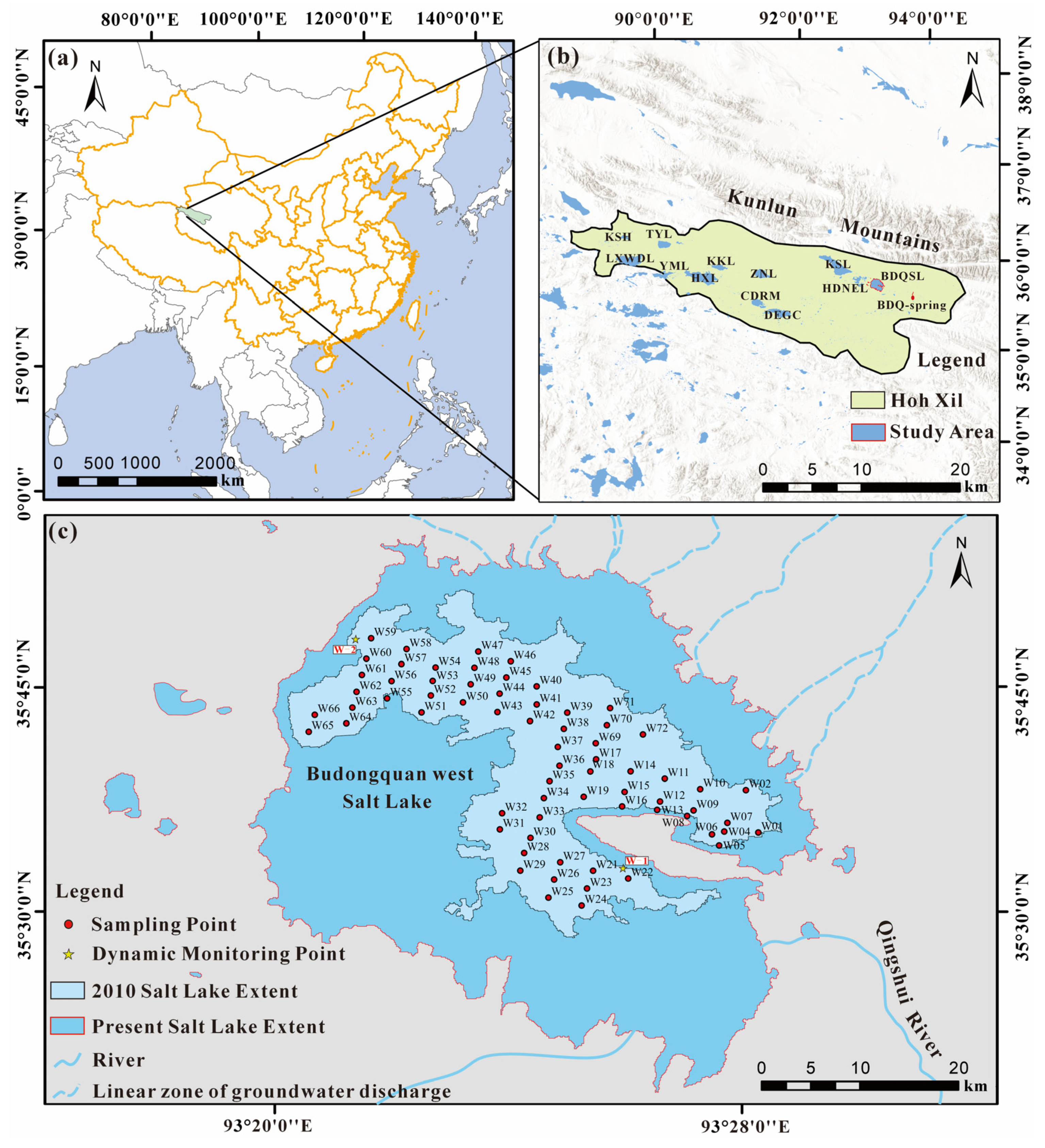
Figure 1. Location and sampling layout of the Budongquan West Salt Lake (BDQSL) study area in Hoh Xil Basin (HXB). (a) China and the northern HXB; (b) location of BDQSL within northern HXB; (c) distribution of sampling points and dynamic monitoring sites, and the lake extents in 2010 versus the present. (Note: BDQSL: Budongquan salt lake; CL: Chang lake; HDNEL: Hedin noel lake; KSL: Kusai lake; ZNL: Zonag lake; CDRM: Codarimu co; DEGC: Dorgai co; KKL: Kekao lake; HXL: Hoh xil lake; KKL-R: Kekao river; YML: Yinma lake; TYL: Taiyang lake; LXWDL: Lexiewudan lake; KSH: Kushui huan; BKDBF-S: Bukatage mountain snow water; DH: Bukatage mountain deep hot spring; DXF-G: Daxuefeng groundwater; BDQ: Budongquan spring).
Water 17 03210 g001
Figure 2. Geological and hydrogeological overview of northern HXB. (modified from Ref. [7]) (Note: BDQSL: Budongquan salt lake; CL: Chang lake; HDNEL: Hedin noel lake; KSL: Kusai lake; ZNL: Zonag lake; CDRM: Codarimu co; DEGC: Dorgai co; KKL: Kekao lake; HXL: Hoh xil lake; KKL–R: Kekao river; YML: Yinma lake; TYL: Taiyang lake; LXWDL: Lexiewudan lake; KSH: Kushui huan; BKDBF–S: Bukatage mountain snow water; DH: Bukatage mountain deep hot spring; DXF–G: Daxuefeng groundwater; BDQ: Budongquan spring).
Water 17 03210 g002
Figure 3. Chemical classification of sampled surface water and groundwater from the HXB using a Piper diagram. (Note: BDQSL: Budongquan salt lake; CL: Chang lake; HDNEL: Hedin noel lake; KSL: Kusai lake; ZNL: Zonag lake; XJWLL: Xijinwulan Lake; WLWLL: Wulanwula Lake; KKL: Kekao lake; HXL: Hoh xil lake; KKL-R: Kekao river; YML: Yinma lake; TYL: Taiyang lake; LXWDL: Lexiewudan lake; MJL: Mingjing Lake; WQ: Wenquan water; CL: Chang Lake; GLCL: Goulu co).
Water 17 03210 g003
Figure 4. B–Li–K ternary equivalent diagram for different water bodies in the HXB. (Note: BDQSL: Budongquan salt lake; CL: Chang lake; HDNEL: Hedin noel lake; KSL: Kusai lake; ZNL: Zonag lake; XJWLL: Xijinwulan Lake; WLWLL: Wulanwula Lake; KKL: Kekao lake; HXL: Hoh xil lake; KKL-R: Kekao river; YML: Yinma lake; TYL: Taiyang lake; LXWDL: Lexiewudan lake; MJL: Mingjing Lake; WQ: Wenquan water; CL: Chang Lake; GLCL: Goulu co).
Water 17 03210 g004
Figure 5. Ion relationship plots for different water bodies in the HXB. (a) Na+ and Cl ions; (b) SO42 + Cl and HCO3 ions; (c) Ca2+ and HCO3 + CO32 ions; (d) Ca2+ + Mg2+ and HCO3 + CO32 ions; (e) Na+ and SO42 ions; (f) Ca2+ + Mg2+ and SO42 ions. (Note: BDQSL data are from this study; data for other water bodies are from [7,15,16,17,42]). (Note: BDQSL: Budongquan salt lake; CL: Chang lake; HDNEL: Hedin noel lake; KSL: Kusai lake; ZNL: Zonag lake; CDRM: Codarimu co; DEGC: Dorgai co; KKL: Kekao lake; HXL: Hoh xil lake; KKL-R: Kekao river; YML: Yinma lake; TYL: Taiyang lake; LXWDL: Lexiewudan lake; KSH: Kushui huan; BKDBF-S: Bukatage mountain snow water; DH: Bukatage mountain deep hot spring; DXF-G: Daxuefeng groundwater; BDQ: Budongquan spring; R: River; G: Groundwater; S: Snow water; SH: Shallow thermal spring).
Water 17 03210 g005
Figure 6. Gibbs diagrams of water samples from different water bodies in the HXB. (a) Na+/(Na++Ca2+) vs. TDS; (b) Cl/(Cl+HCO3) vs. TDS. (Note: BDQSL: Budongquan salt lake; CL: Chang lake; HDNEL: Hedin noel lake; KSL: Kusai lake; ZNL: Zonag lake; CDRM: Codarimu co; DEGC: Dorgai co; KKL: Kekao lake; HXL: Hoh xil lake; KKL-R: Kekao river; YML: Yinma lake; TYL: Taiyang lake; LXWDL: Lexiewudan lake; KSH: Kushui huan; BKDBF-S: Bukatage mountain snow water; DH: Bukatage mountain deep hot spring; DXF-G: Daxuefeng groundwater; BDQ: Budongquan spring; R: River; G: Groundwater; S: Snow water; SH: Shallow thermal spring).
Water 17 03210 g006
Figure 7. (a) Distributions of B and Li concentrations in different water bodies of northern HXB; (b) Distributions of TDS and pH across the different water bodies.
Water 17 03210 g007
Figure 8. Linear regression analysis of B3+ and Li+ in water samples from different water bodies in the HXB. (Note: BDQSL: Budongquan salt lake; CL: Chang lake; HDNEL: Hedin noel lake; KSL: Kusai lake; ZNL: Zonag lake; XJWLL: Xijinwulan Lake; WLWLL: Wulanwula Lake; KKL: Kekao lake; HXL: Hoh xil lake; KKL-R: Kekao river; YML: Yinma lake; TYL: Taiyang lake; LXWDL: Lexiewudan lake; MJL: Mingjing Lake; CL: Chang Lake; GLCL: Goulu co; R: River).
Water 17 03210 g008
Figure 9. (a) δD–δ18O relationship for different water bodies in the HXB; (b) TDS versus d-excess (‰). (Note: BDQSL: Budongquan salt lake; HDNEL: Hedin noel lake; KSL: Kusai lake; ZNL: Zonag lake; XJWLL: Xijinwulan Lake; WLWLL: Wulanwula Lake; KKL: Kekao lake; HXL: Hoh xil lake; G: Groundwater; YML: Yinma lake; TYL: Taiyang lake; LXWDL: Lexiewudan lake; R: River; CDRM: Codarimu co; BKDBF-S: Bukatage mountain snow water; DH: Bukatage mountain deep hot spring; DXF-G: Daxuefeng groundwater).
Water 17 03210 g009
Figure 10. Weathering-type diagram for different water bodies in the HXB. (a) Mg/Na vs. Ca/Na ratio plot; (b) HCO3/Na vs. Ca/Na ratio plot. (Note: BDQSL: Budongquan salt lake; CL: Chang lake; HDNEL: Hedin noel lake; KSL: Kusai lake; ZNL: Zonag lake; CDRM: Codarimu co; KKL: Kekao lake; HXL: Hoh xil lake; KKL-R: Kekao river; YML: Yinma lake; TYL: Taiyang lake; LXWDL: Lexiewudan lake; BKDBF-S: Bukatage mountain snow water; DH: Bukatage mountain deep hot spring; DXF-G: Daxuefeng groundwater; R: River; G: Groundwater; S: Snow water; SH: Shallow thermal spring).
Water 17 03210 g010
Figure 11. Conceptual model of evaporite-bearing stratigraphic deposition and halogenesis in the HXB. (a) Geological structural map of the study area; (b) Halogenesis model of endorheic dry salt lake (Tuotuo River Basin); (c) Halogenesis model of open-basin salt lake (Cuoren Dejia Basin). (Modified from [25]).
Water 17 03210 g011
Disclaimer/Publisher’s Note: The statements, opinions and data contained in all publications are solely those of the individual author(s) and contributor(s) and not of MDPI and/or the editor(s). MDPI and/or the editor(s) disclaim responsibility for any injury to people or property resulting from any ideas, methods, instructions or products referred to in the content.