Hanjiang River Runoff Change and Its Attribution Analysis Integrating the Inter-Basin Water Transfer


Abstract
:1. Introduction
2. Materials and Methods
2.1. Materials
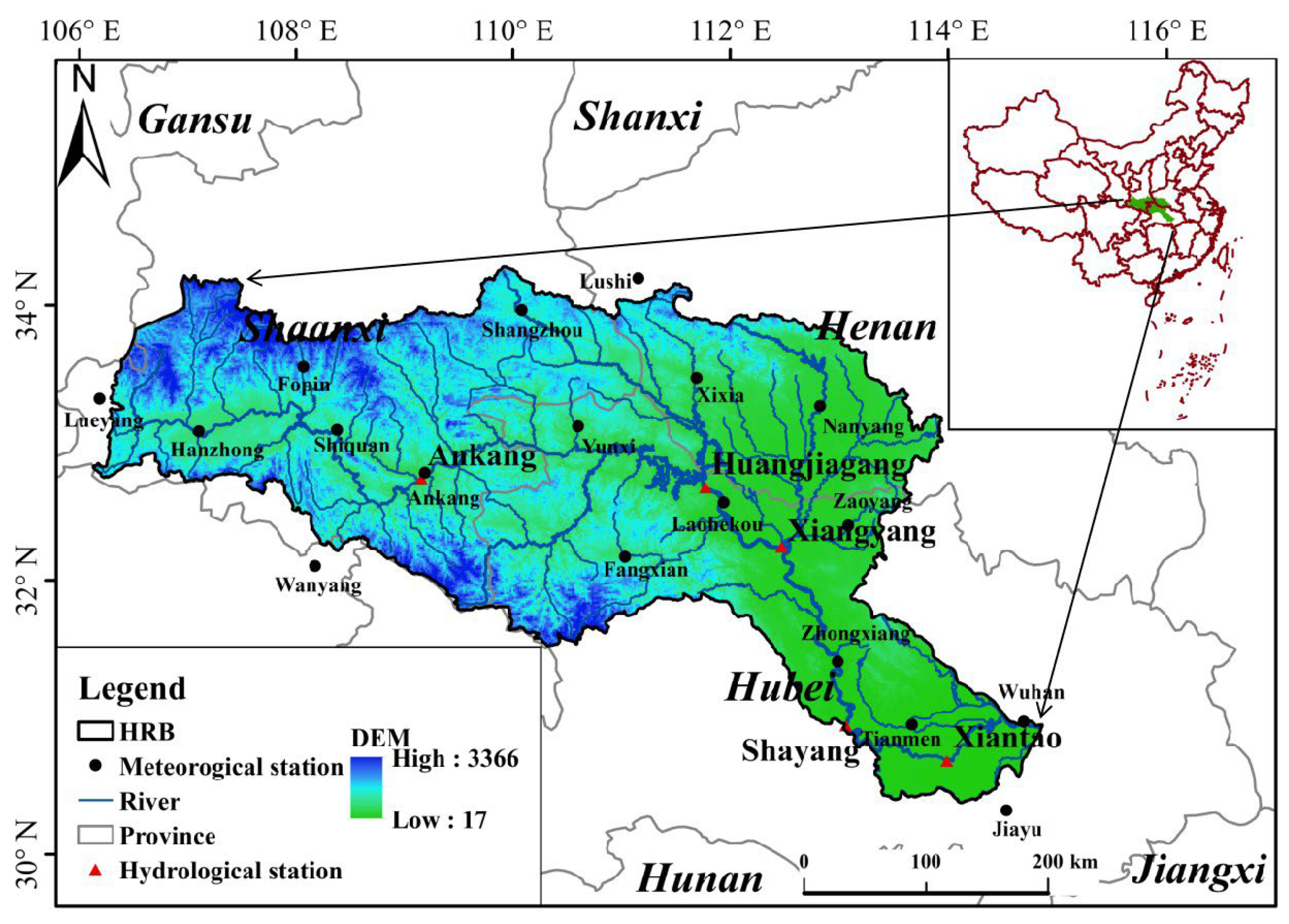
2.1.1. Study Area
2.1.2. Data Sources
2.2. Methods
2.2.1. Calculation of Climate Factors
2.2.2. Calculation of Annual Runoff Depth
2.2.3. Mann–Kendall Test
- (1)
- Man–Kendall trend test
- (2)
- Mann–Kendall abrupt change test
2.2.4. Pettitt Test
2.2.5. Sustainability Test
2.2.6. Attribution Analysis Method
3. Results
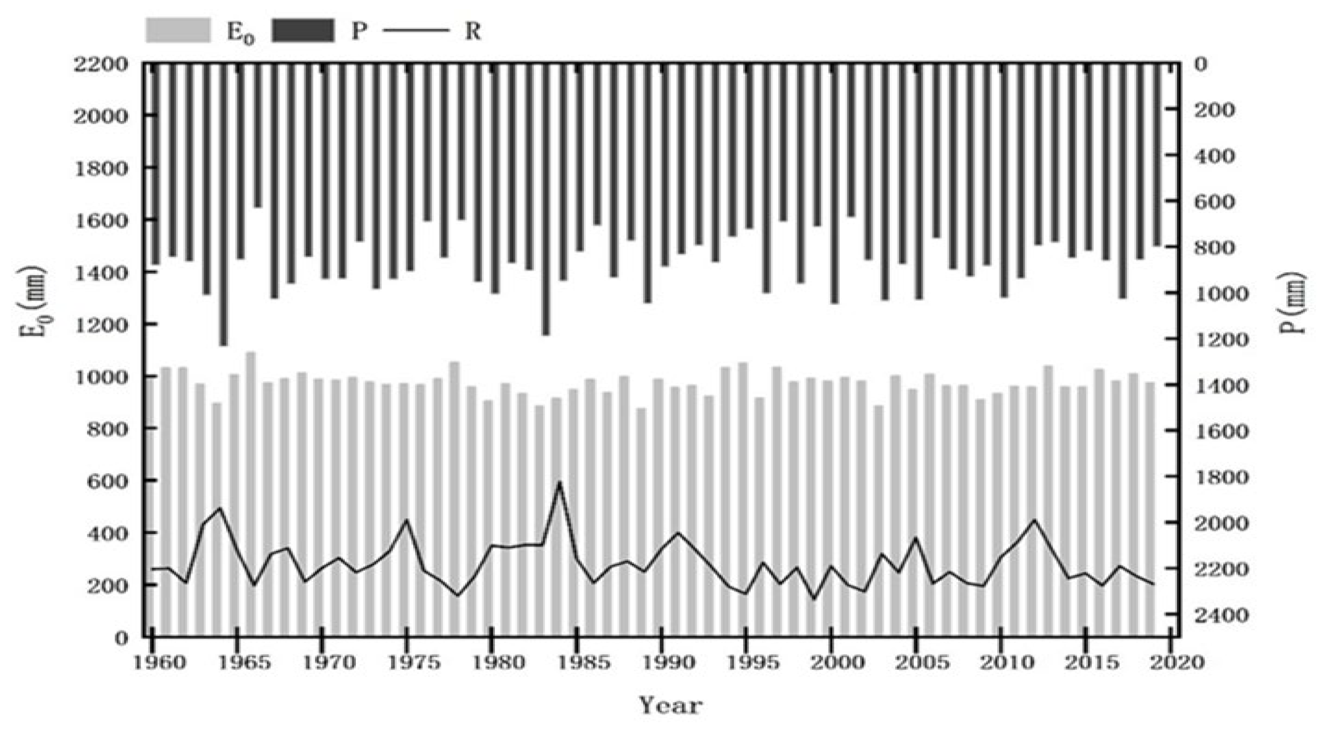
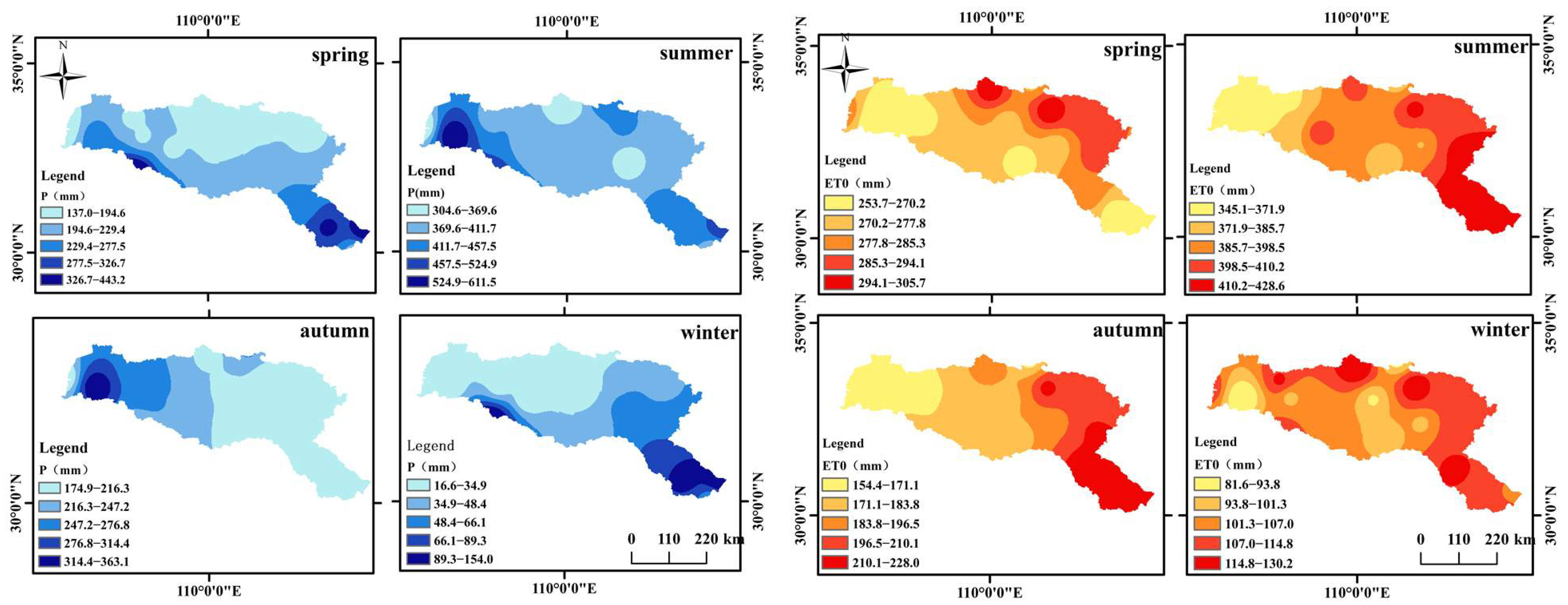
3.1. Trends in Precipitation, ET0
3.2. Trends in Runoff
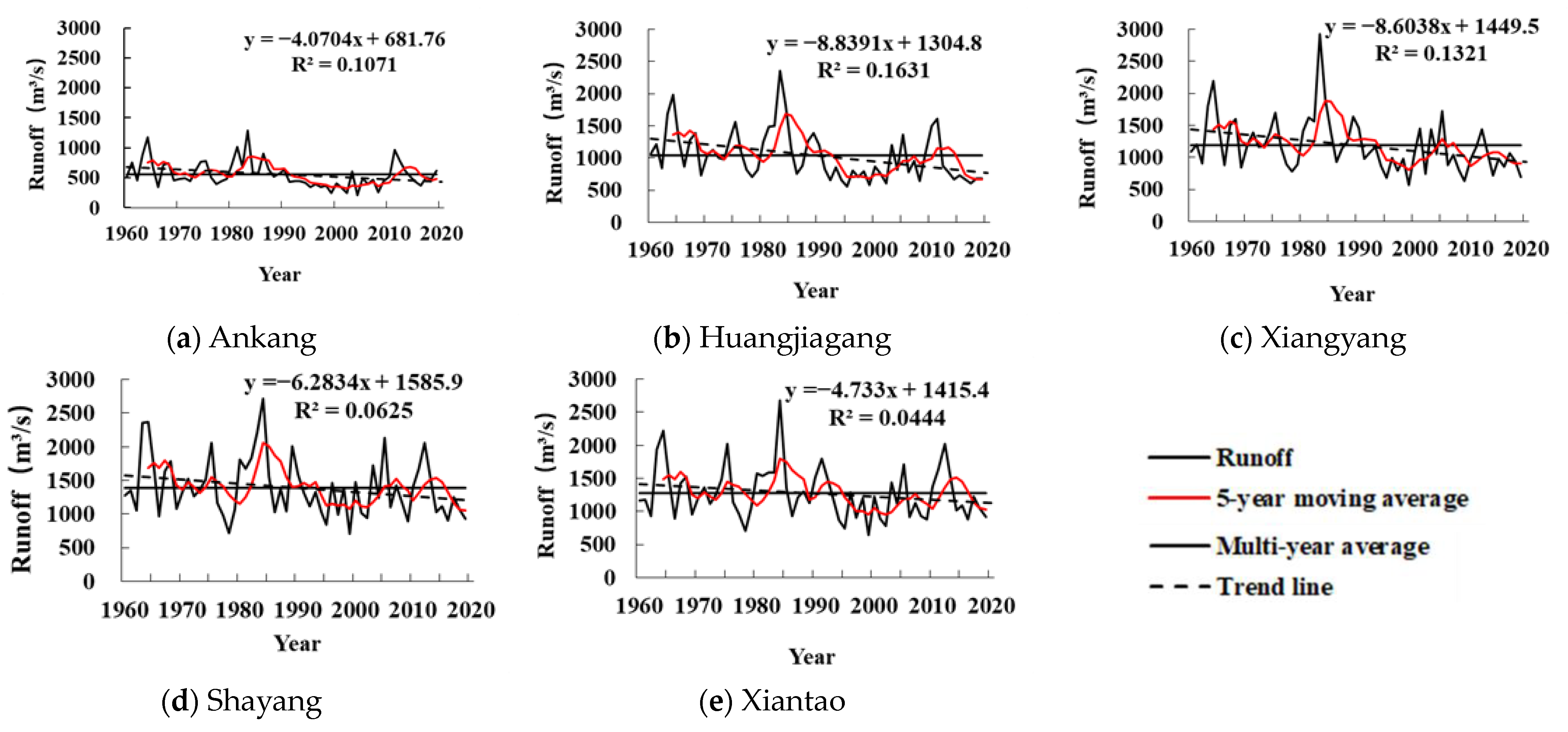
3.2.1. Interannual Temporal Variation
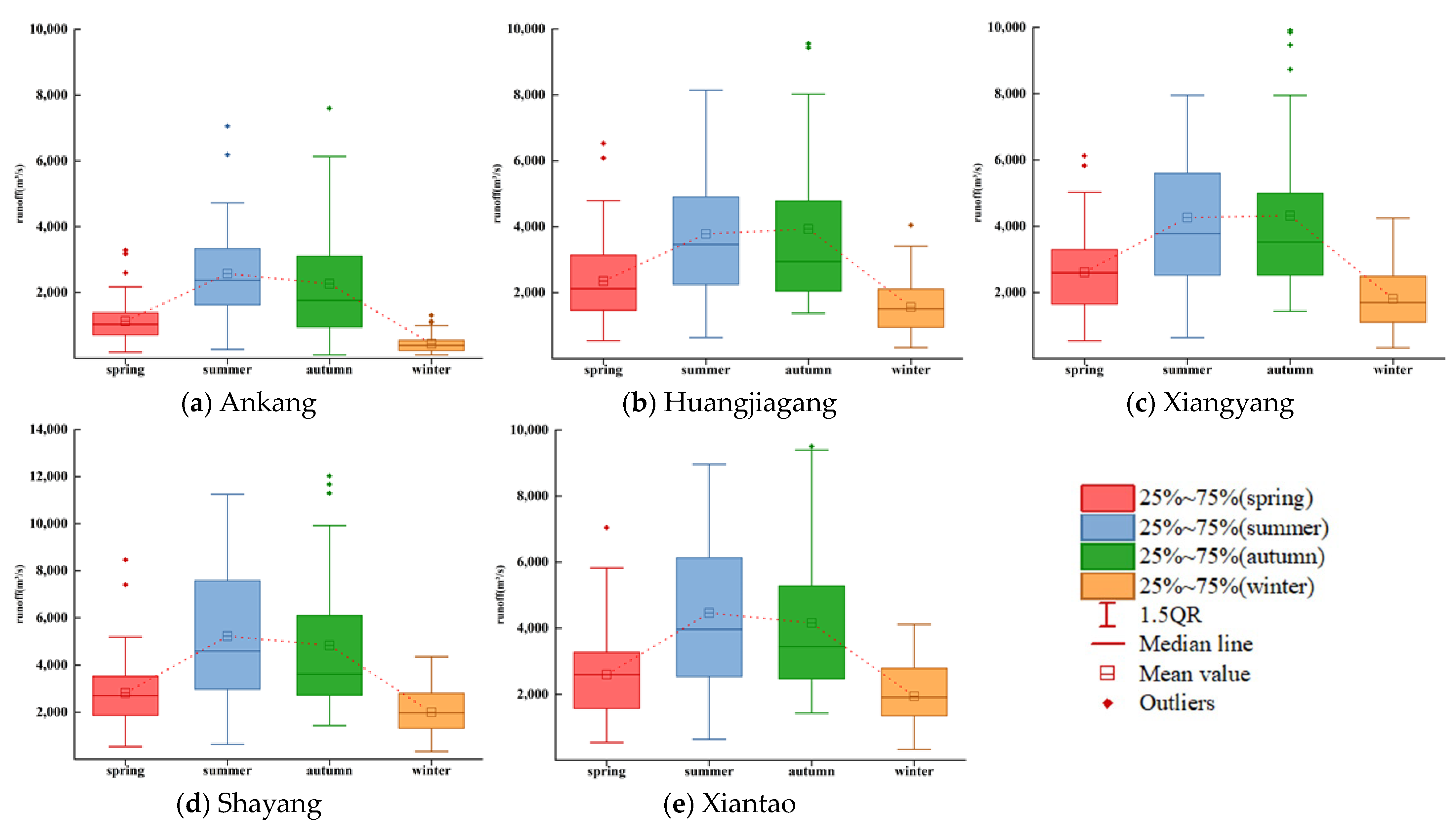
3.2.2. Intra-Annual Distribution
3.2.3. Persistent Characteristics
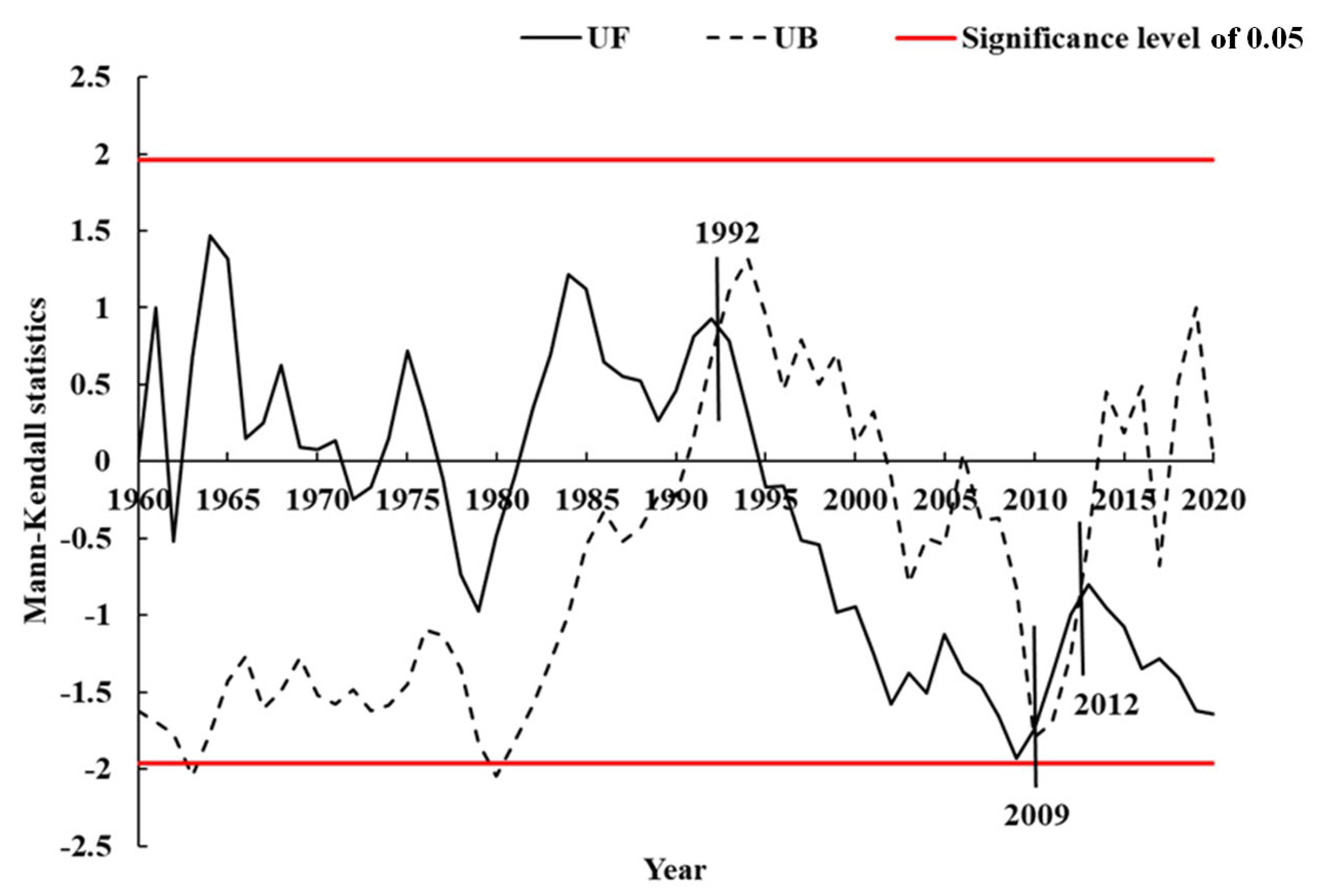
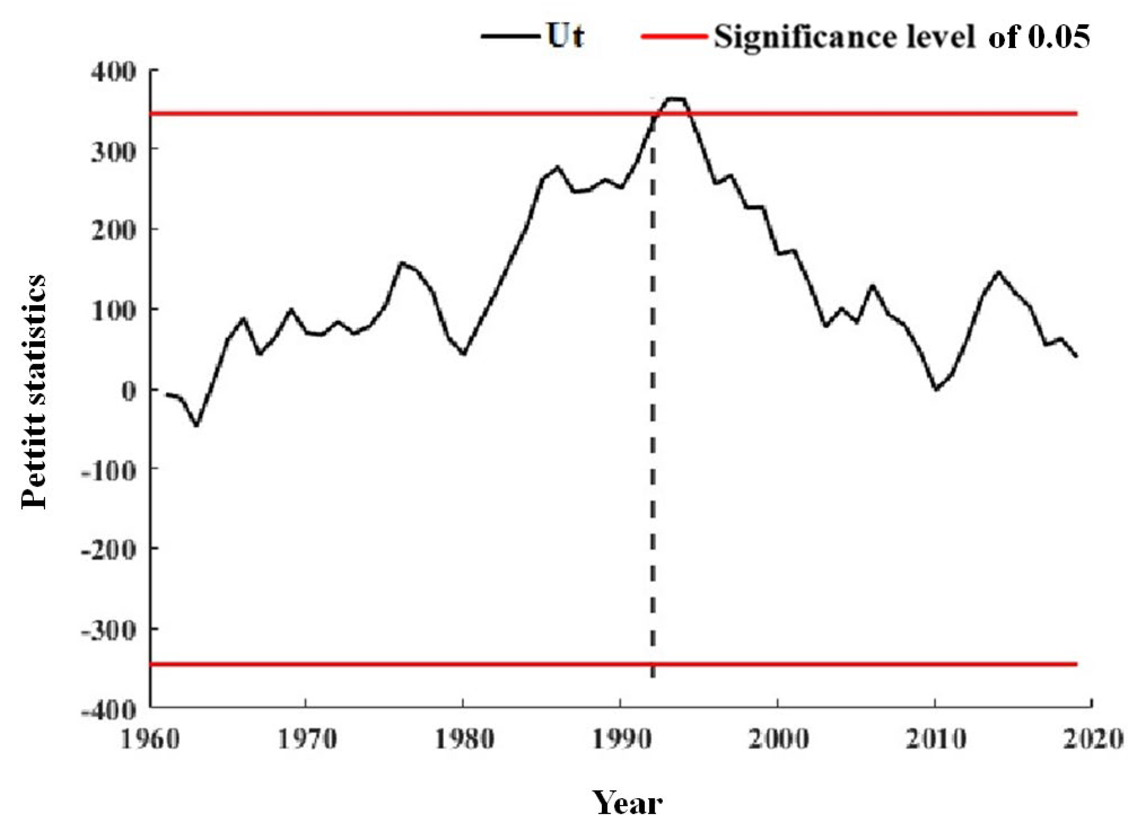
3.3. Detection of Runoff Abrupt Change Points
3.4. Sensitivity Analysis
3.5. Attribution Analysis
4. Discussion
5. Conclusions, Limitations, and Future Directions
5.1. Conclusions
- Precipitation and ET0 had a decreasing trend over the period of 1960–2019, albeit statistically insignificantly, and meanwhile, they had great spatial heterogeneity. In terms of seasons, the temporal patterns and spatial distribution were different. The interannual and spatial variation of ET0 was much slighter compared to that of precipitation.
- The annual runoff at the five hydrological stations decreased significantly with time, but their declining patterns were different. Different from Ankang station upstream, the other four stations in the Jianghan Plain had slighter variability, a more significant downward trend, and weaker persistence in annual runoff and increasing wintertime runoff, which was attributed to the joint operation of the Danjiangkou Reservoir and MRP-SNWD.
- The elasticity coefficients of ET0, n, and precipitation tended to increase with time, and runoff was the most sensitive to changes in precipitation. The most significant impact on runoff reduction during the change period was human activities, with their contribution rate reaching 73.09% during the first change period (1993–2012) and 52.56% during the second change period (2013–2019), followed by precipitation, and ET0 had little influence on runoff during two change periods.
- The contribution of the influence of the MRP-SNWD on runoff change was 20.3%.
5.2. Limitations and Future Directions
- It is noteworthy that our study still has some limitations. For example, there are uncertainties in the Budyko method, especially when considering the complex interactions between human activities and climate change in the Hanjiang River. Nevertheless, the results can still be valuable, reflecting the impacts of climate change, the MRP-SNWD, and other human activities on the changes in the Hanjiang River runoff.
- Our study only focuses on changes in water quantity in the Hanjiang River basin, with inadequate studies of environmental flows that may have implications for water quality, aquatic organisms, and other water-related ecosystems. In light of the recent occurrence of cyanobacterial outbreaks and other water-related ecological events throughout the middle and lower reaches, further research on ecological flows must be needed to address the water quality issue. In addition, ecological security evaluation and early warning systems should be carried out to identify ecological security risks. In addition, long-term monitoring, extensive research, improved legislation, policies, and management practices, including ecological compensation, are needed to alleviate negative environmental impacts.
- The MRP-SNWD has had a significant effect and will continue to have a significant impact on the water balance of the Hanjiang River. So we urgently need to seek moves that make a difference and flip the script in the Hanjiang River, turning vulnerability into resilience. Non-engineering approaches are needed to move towards sustainable water management. For example, in the receiving-water area of the MRP-SNWD, there should be strict rules on water resource conservation, reducing water withdrawals and increasing ecological flows to the rivers. It is also crucial to integrate the YHWD into the national water network, linking two of China’s major water projects. This will remarkably enhance the resilience of the MRP-SNWD, benefiting the local population living along the Hanjiang River, while meeting the water needs of the country’s parched north. At the same time, joint optimal scheduling of the MRP-SNWD, YHWD, and cascading reservoirs is urgently needed to ensure sustainable water management in the Hanjiang River basin.
Author Contributions
Funding
Data Availability Statement
Conflicts of Interest
References
- Langhammer, J.; Su, Y.; Bernsteinová, J. Runoff Response to Climate Warming and Forest Disturbance in a Mid-Mountain Basin. Water 2015, 7, 3320–3342. [Google Scholar] [CrossRef]
- Yang, B.; Dou, M.; Xia, R.; Kuo, Y.-M.; Li, G.; Shen, L. Effects of Hydrological Alteration on Fish Population Structure and Habitat in River System: A Case Study in the Mid-Downstream of the Hanjiang River in China. Glob. Ecol. Conserv. 2020, 23, e01090. [Google Scholar] [CrossRef]
- Kim, S.; Noh, H.; Jung, J.; Jun, H.; Kim, H. Assessment of the Impacts of Global Climate Change and Regional Water Projects on Streamflow Characteristics in the Geum River Basin in Korea. Water 2016, 8, 91. [Google Scholar] [CrossRef]
- Zhang, Y.; Zhong, P.; Chen, J.; Bing, J.; Xu, D.; Wang, M. Impacts of Climate Change and Human Activities on the Three Gorges Reservoir Inflow. Water 2017, 9, 957. [Google Scholar] [CrossRef]
- Sorg, A.; Bolch, T.; Stoffel, M.; Solomina, O.; Beniston, M. Climate Change Impacts on Glaciers and Runoff in Tien Shan (Central Asia). Nat. Clim. Chang. 2012, 2, 725–731. [Google Scholar] [CrossRef]
- Kumar, R.; Manzoor, S.; Vishwakarma, D.K.; Al-Ansari, N.; Kushwaha, N.L.; Elbeltagi, A.; Sushanth, K.; Prasad, V.; Kuriqi, A. Assessment of Climate Change Impact on Snowmelt Runoff in Himalayan Region. Sustainability 2022, 14, 1150. [Google Scholar] [CrossRef]
- Cadol, D.; Kampf, S.; Wohl, E. Effects of Evapotranspiration on Baseflow in a Tropical Headwater Catchment. J. Hydrol. 2012, 462–463, 4–14. [Google Scholar] [CrossRef]
- Suzuki, K.; Matsuo, K.; Yamazaki, D.; Ichii, K.; Iijima, Y.; Papa, F.; Yanagi, Y.; Hiyama, T. Hydrological Variability and Changes in the Arctic Circumpolar Tundra and the Three Largest Pan-Arctic River Basins from 2002 to 2016. Remote Sens. 2018, 10, 402. [Google Scholar] [CrossRef]
- Luo, K. Contribution of Ecological Conservation Programs and Climate Change to Hydrological Regime Change in the Source Region of the Yangtze River in China. Reg. Env. Chang. 2022, 22, 10. [Google Scholar] [CrossRef]
- Vicente-Serrano, S.M.; Peña-Gallardo, M.; Hannaford, J.; Murphy, C.; Lorenzo-Lacruz, J.; Dominguez-Castro, F.; López-Moreno, J.I.; Beguería, S.; Noguera, I.; Harrigan, S.; et al. Climate, Irrigation, and Land Cover Change Explain Streamflow Trends in Countries Bordering the Northeast Atlantic. Geophys. Res. Lett. 2019, 46, 10821–10833. [Google Scholar] [CrossRef]
- Long, D.; Yang, W.; Scanlon, B.R.; Zhao, J.; Liu, D.; Burek, P.; Pan, Y.; You, L.; Wada, Y. South-to-North Water Diversion Stabilizing Beijing’s Groundwater Levels. Nat. Commun. 2020, 11, 3665. [Google Scholar] [CrossRef]
- Liu, X.; Luo, Y.; Yang, T.; Liang, K.; Zhang, M.; Liu, C. Investigation of the Probability of Concurrent Drought Events between the Water Source and Destination Regions of China’s Water Diversion Project: DROUGHT OF CHINA’S WATER DIVERSION. Geophys. Res. Lett. 2015, 42, 8424–8431. [Google Scholar] [CrossRef]
- Kazemi, H.; Sarukkalige, R.; Badrzadeh, H. Evaluation of Streamflow Changes Due to Climate Variation and Human Activities Using the Budyko Approach. Env. Earth Sci. 2019, 78, 713. [Google Scholar] [CrossRef]
- Wagner, P.D.; Bhallamudi, S.M.; Narasimhan, B.; Kantakumar, L.N.; Sudheer, K.P.; Kumar, S.; Schneider, K.; Fiener, P. Dynamic Integration of Land Use Changes in a Hydrologic Assessment of a Rapidly Developing Indian Catchment. Sci. Total Environ. 2016, 539, 153–164. [Google Scholar] [CrossRef]
- Li, H.; Shi, C.; Sun, P.; Zhang, Y.; Collins, A.L. Attribution of Runoff Changes in the Main Tributaries of the Middle Yellow River, China, Based on the Budyko Model with a Time-Varying Parameter. CATENA 2021, 206, 105557. [Google Scholar] [CrossRef]
- Hussain, A.; Cao, J.; Ali, S.; Ullah, W.; Muhammad, S.; Hussain, I.; Rezaei, A.; Hamal, K.; Akhtar, M.; Abbas, H.; et al. Variability in Runoff and Responses to Land and Oceanic Parameters in the Source Region of the Indus River. Ecol. Indic. 2022, 140, 109014. [Google Scholar] [CrossRef]
- Naik, P.K.; Jay, D.A. Distinguishing Human and Climate Influences on the Columbia River: Changes in Mean Flow and Sediment Transport. J. Hydrol. 2011, 404, 259–277. [Google Scholar] [CrossRef]
- Rodell, M.; Famiglietti, J.S.; Wiese, D.N.; Reager, J.T.; Beaudoing, H.K.; Landerer, F.W.; Lo, M.-H. Emerging Trends in Global Freshwater Availability. Nature 2018, 557, 651–659. [Google Scholar] [CrossRef]
- Zhang, X.; Yang, H.; Zhang, W.; Fenicia, F.; Peng, H.; Xu, G. Hydrologic Impacts of Cascading Reservoirs in the Middle and Lower Hanjiang River Basin under Climate Variability and Land Use Change. J. Hydrol. Reg. Stud. 2022, 44, 101253. [Google Scholar] [CrossRef]
- He, Y.; Hu, Y.; Song, J.; Jiang, X. Variation of Runoff between Southern and Northern China and Their Attribution in the Qinling Mountains, China. Ecol. Eng. 2021, 171, 106374. [Google Scholar] [CrossRef]
- Yonaba, R.; Biaou, A.C.; Koïta, M.; Tazen, F.; Mounirou, L.A.; Zouré, C.O.; Queloz, P.; Karambiri, H.; Yacouba, H. A Dynamic Land Use/Land Cover Input Helps in Picturing the Sahelian Paradox: Assessing Variability and Attribution of Changes in Surface Runoff in a Sahelian Watershed. Sci. Total Environ. 2021, 757, 143792. [Google Scholar] [CrossRef] [PubMed]
- Yuan, Z.; Xu, J.; Wang, Y. Historical and Future Changes of Blue Water and Green Water Resources in the Yangtze River Source Region, China. Appl. Clim. 2019, 138, 1035–1047. [Google Scholar] [CrossRef]
- Fatichi, S.; Vivoni, E.R.; Ogden, F.L.; Ivanov, V.Y.; Mirus, B.; Gochis, D.; Downer, C.W.; Camporese, M.; Davison, J.H.; Ebel, B.; et al. An Overview of Current Applications, Challenges, and Future Trends in Distributed Process-Based Models in Hydrology. J. Hydrol. 2016, 537, 45–60. [Google Scholar] [CrossRef]
- Huang, S.; Chang, J.; Huang, Q.; Chen, Y.; Leng, G. Quantifying the Relative Contribution of Climate and Human Impacts on Runoff Change Based on the Budyko Hypothesis and SVM Model. Water Resour. Manag. 2016, 30, 2377–2390. [Google Scholar] [CrossRef]
- Xu, X.; Yang, D.; Yang, H.; Lei, H. Attribution Analysis Based on the Budyko Hypothesis for Detecting the Dominant Cause of Runoff Decline in Haihe Basin. J. Hydrol. 2014, 510, 530–540. [Google Scholar] [CrossRef]
- Melo, P.A.; Alvarenga, L.A.; Tomasella, J.; De Mello, C.R.; Martins, M.A.; Coelho, G. Analysis of Hydrological Impacts Caused by Climatic and Anthropogenic Changes in Upper Grande River Basin, Brazil. Environ. Earth Sci. 2022, 81, 504. [Google Scholar] [CrossRef]
- Shi, G.; Gao, B. Attribution Analysis of Runoff Change in the Upper Reaches of the Kaidu River Basin Based on a Modified Budyko Framework. Atmosphere 2022, 13, 1385. [Google Scholar] [CrossRef]
- Ni, Y.; Lv, X.; Yu, Z.; Wang, J.; Ma, L.; Zhang, Q. Intra-Annual Variation in the Attribution of Runoff Evolution in the Yellow River Source Area. CATENA 2023, 225, 107032. [Google Scholar] [CrossRef]
- Liu, J.; Chen, J.; Xu, J.; Lin, Y.; Yuan, Z.; Zhou, M. Attribution of Runoff Variation in the Headwaters of the Yangtze River Based on the Budyko Hypothesis. IJERPH 2019, 16, 2506. [Google Scholar] [CrossRef]
- Wang, Y.; Wang, D.; Wu, J. Assessing the Impact of Danjiangkou Reservoir on Ecohydrological Conditions in Hanjiang River, China. Ecol. Eng. 2015, 81, 41–52. [Google Scholar] [CrossRef]
- Li, L.; Zhang, L.; Xia, J.; Gippel, C.J.; Wang, R.; Zeng, S. Implications of Modelled Climate and Land Cover Changes on Runoff in the Middle Route of the South to North Water Transfer Project in China. Water Resour. Manag. 2015, 29, 2563–2579. [Google Scholar] [CrossRef]
- Yang, Q.; Liu, D.F.; Liu, H.; Meng, X.M.; Huang, Q.; Lin, M. Distributed Hydrological Modelling at Multiple Hydrological Stations in the Upper Reach of Han River Based on SWAT Model. IOP Conf. Ser. Earth Environ. Sci. 2019, 344, 012081. [Google Scholar] [CrossRef]
- Zhang, C.; Duan, Q.; Yeh, P.J.-F.; Pan, Y.; Gong, H.; Gong, W.; Di, Z.; Lei, X.; Liao, W.; Huang, Z.; et al. The Effectiveness of the South-to-North Water Diversion Middle Route Project on Water Delivery and Groundwater Recovery in North China Plain. Water Resour. Res. 2020, 56, e2019WR026759. [Google Scholar] [CrossRef]
- Jiang, X.; Ma, R.; Ma, T.; Sun, Z. Modeling the Effects of Water Diversion Projects on Surface Water and Groundwater Interactions in the Central Yangtze River Basin. Sci. Total Environ. 2022, 830, 154606. [Google Scholar] [CrossRef] [PubMed]
- Yin, X.; Zhang, J.; Chen, J. The Impact of Multi-Projects on the Alteration of the Flow Regime in the Middle and Lower Course of the Hanjiang River, China. Water 2020, 12, 2301. [Google Scholar] [CrossRef]
- Xia, R.; Zou, L.; Zhang, Y.; Zhang, Y.; Chen, Y.; Liu, C.; Yang, Z.; Ma, S. Algal Bloom Prediction Influenced by the Water Transfer Project in the Middle-Lower Hanjiang River. Ecol. Model. 2022, 463, 109814. [Google Scholar] [CrossRef]
- Smith, M. Report on the Expert Consultation on Revision of FAO Methodologies for Crop Water Requirements. Food and Agriculture Organization of the United Nations: Rome, Italy, 1992. [Google Scholar]
- Fiedler, F.R. Simple, Practical Method for Determining Station Weights Using Thiessen Polygons and Isohyetal Maps. J. Hydrol. Eng. 2003, 8, 219–221. [Google Scholar] [CrossRef]
- Yue, S.; Pilon, P.; Phinney, B.; Cavadias, G. The Influence of Autocorrelation on the Ability to Detect Trend in Hydrological Series. Hydrol. Process. 2002, 16, 1807–1829. [Google Scholar] [CrossRef]
- Pettitt, A.N. A Non-Parametric Approach to the Change-Point Problem. Appl. Stat. 1979, 28, 126. [Google Scholar] [CrossRef]
- Li, J.; Tan, S.; Wei, Z.; Chen, F.; Feng, P. A New Method of Change Point Detection Using Variable Fuzzy Sets under Environmental Change. Water Resour. Manag. 2014, 28, 5125–5138. [Google Scholar] [CrossRef]
- Zhang, J.; Hu, Q.; Wang, S.; Ai, M. Variation Trend Analysis of Runoff and Sediment Time Series Based on the R/S Analysis of Simulated Loess Tilled Slopes in the Loess Plateau, China. Sustainability 2017, 10, 32. [Google Scholar] [CrossRef]
- Kamenshchikov, S.A. Transport Catastrophe Analysis as an Alternative to a Monofractal Description: Theory and Application to Financial Crisis Time Series. J. Chaos 2014, 2014, 346743. [Google Scholar] [CrossRef]
- A Comprehensive Assessment Framework for Quantifying Climatic and Anthropogenic Contributions to Streamflow Changes: A Case Study in a Typical Semi-Arid North China Basin-ScienceDirect. Available online: https://www.sciencedirect.com/science/article/abs/pii/S1364815220301213 (accessed on 29 July 2023).
- Choudhury, B. Evaluation of an Empirical Equation for Annual Evaporation Using Field Observations and Results from a Biophysical Model. J. Hydrol. 1999, 216, 99–110. [Google Scholar] [CrossRef]
- Yang, H.; Yang, D.; Lei, Z.; Sun, F. New Analytical Derivation of the Mean Annual Water-Energy Balance Equation. Water Resour. Res. 2008, 44, W03410. [Google Scholar] [CrossRef]
- Li, H.; Wang, W.; Fu, J.; Chen, Z.; Ning, Z.; Liu, Y. Quantifying the Relative Contribution of Climate Variability and Human Activities Impacts on Baseflow Dynamics in the Tarim River Basin, Northwest China. J. Hydrol. Reg. Stud. 2021, 36, 100853. [Google Scholar] [CrossRef]
- Yu, Z.; Gu, H.; Wang, J.; Xia, J.; Lu, B. Effect of Projected Climate Change on the Hydrological Regime of the Yangtze River Basin, China. Stoch. Environ. Res. Risk Assess. 2018, 32, 1–16. [Google Scholar] [CrossRef]
- Peng, T.; Mei, Z.; Dong, X.; Wang, J.; Liu, J.; Chang, W.; Wang, G. Attribution of Runoff Changes in the Hanjiang River Basin Based on Budyko Hypothesis. South–North Water Transf. Water Sci. Technol. 2021, 19, 1114–1124. (In Chinese) [Google Scholar] [CrossRef]
- Ni, Y.; Yu, Z.; Lv, X.; Qin, T.; Yan, D.; Zhang, Q.; Ma, L. Spatial Difference Analysis of the Runoff Evolution Attribution in the Yellow River Basin. J. Hydrol. 2022, 612, 128149. [Google Scholar] [CrossRef]
- Yang, S.; Liu, J.; Wang, C.; Zhang, T.; Dong, X.; Liu, Y. Vegetation Dynamics Influenced by Climate Change and Human Activities in the Hanjiang River Basin, Central China. Ecol. Indic. 2022, 145, 109586. [Google Scholar] [CrossRef]
- Truong, N.; Nguyen, H.; Kondoh, A. Land Use and Land Cover Changes and Their Effect on the Flow Regime in the Upstream Dong Nai River Basin, Vietnam. Water 2018, 10, 1206. [Google Scholar] [CrossRef]
- Luo, K.; Moiwo, J.P. Sensitivity of the Land Surface Hydrological Cycle to Human Activities in China. Gondwana Res. 2022, S1342937X22001071, in press. [Google Scholar] [CrossRef]
- Qi, B.; Liu, H.; Zhao, S.; Liu, B. Observed Precipitation Pattern Changes and Potential Runoff Generation Capacity from 1961–2016 in the Upper Reaches of the Hanjiang River Basin, China. Atmos. Res. 2021, 254, 105392. [Google Scholar] [CrossRef]
- Zou, Y.; Yan, B.; Feng, B.; Zhang, J.; Tang, Y. A Three-Parameter Hydrological Model for Monthly Runoff Simulation—A Case Study of Upper Hanjiang River Basin. Water 2023, 15, 474. [Google Scholar] [CrossRef]
- Wang, Y.; Zhang, W.; Zhao, Y.; Peng, H.; Shi, Y. Modelling Water Quality and Quantity with the Influence of Inter-Basin Water Diversion Projects and Cascade Reservoirs in the Middle-Lower Hanjiang River. J. Hydrol. 2016, 541, 1348–1362. [Google Scholar] [CrossRef]
- Nkhoma, L.; Ngongondo, C.; Dulanya, Z.; Monjerezi, M. Evaluation of Integrated Impacts of Climate and Land Use Change on the River Flow Regime in Wamkurumadzi River, Shire Basin in Malawi. J. Water Clim. Chang. 2021, 12, 1674–1693. [Google Scholar] [CrossRef]
- Zhang, Y.; Ban, X.; Li, E.; Wang, Z.; Xiao, F. Evaluating Ecological Health in the Middle-Lower Reaches of the Hanjiang River with Cascade Reservoirs Using the Planktonic Index of Biotic Integrity (P-IBI). Ecol. Indic. 2020, 114, 106282. [Google Scholar] [CrossRef]

| Average Precipitation (mm) | Z | Average ET0 (mm) | Z | |
|---|---|---|---|---|
| year | 881 | −0.13 | 974 | −0.86 |
| spring | 239 | −0.98 | 277 | 1.96 |
| summer | 478 | 0.41 | 394 | −2.90 |
| autumn | 263 | −1.37 | 188 | −0.30 |
| winter | 47 | 0.11 | 106 | −0.72 |
| Hydrological Stations | Multi-Year Average (m3/s) | Extreme Value Ratio | CV | Z | H |
|---|---|---|---|---|---|
| Ankang | 558 | 6.10 | 0.39 | −2.65 | 0.81 |
| Huangjiagang | 1035 | 4.24 | 0.37 | −3.85 | 0.77 |
| Xiangyang | 1187 | 5.12 | 0.35 | −3.09 | 0.73 |
| Shayang | 1394 | 3.83 | 0.35 | −1.94 | 0.64 |
| Xiantao | 1271 | 4.14 | 0.31 | −1.60 | 0.63 |
| Season | Ankang | Huangjiagang | Xiangyang | Shayang | Xiantao |
|---|---|---|---|---|---|
| spring | −4.28 | −1.74 | −2.35 | −1.42 | −2.22 |
| summer | −0.64 | −2.31 | −2.55 | −1.69 | −2.35 |
| autumn | −3.24 | −3.74 | −3.51 | −3.25 | −2.83 |
| winter | −5.12 | 1.52 | 0.82 | 1.37 | 0.39 |
| Period | ET0/mm | R/mm | P/mm | n | R/P | ET0/P | Elasticity Coefficient | ||
|---|---|---|---|---|---|---|---|---|---|
| ƐET0 | Ɛp | Ɛn | |||||||
| 1960–1992 | 978 | 308 | 893 | 1.48 | 0.35 | 1.10 | −0.89 | 1.89 | −0.88 |
| 1993–2012 | 975 | 257 | 871 | 1.72 | 0.29 | 1.12 | −1.08 | 2.08 | −0.96 |
| 2013–2019 | 995 | 244 | 854 | 1.70 | 0.28 | 1.17 | −1.09 | 2.09 | −1.01 |
| 2013–2019 * | 995 | 264 | 854 | 1.57 | 0.31 | 1.17 | −0.98 | 1.98 | −0.98 |
| Base Period | Change Period | ΔRP (mm) | ΔRET0 (mm) | ΔRn (mm) | ΔR’ | ΔR | CP (%) | CET0 (%) | Cn (%) |
|---|---|---|---|---|---|---|---|---|---|
| 1960–1992 | 1993–2012 | −13.41 | 0.84 | −34.14 | −46.70 | −51.75 | 28.70 | −1.80 | 73.09 |
| 2013–2019 | −23.42 | −4.50 | −30.94 | −58.87 | −63.98 | 39.79 | 7.65 | 52.56 | |
| 2013–2019 * | −24.05 | −4.40 | −13.56 | −42.05 | −43.77 | 57.27 | 10.47 | 32.26 |
Disclaimer/Publisher’s Note: The statements, opinions and data contained in all publications are solely those of the individual author(s) and contributor(s) and not of MDPI and/or the editor(s). MDPI and/or the editor(s) disclaim responsibility for any injury to people or property resulting from any ideas, methods, instructions or products referred to in the content. |
© 2023 by the authors. Licensee MDPI, Basel, Switzerland. This article is an open access article distributed under the terms and conditions of the Creative Commons Attribution (CC BY) license (https://creativecommons.org/licenses/by/4.0/).
Share and Cite
Wu, G.; Liu, Y.; Liu, B.; Ren, H.; Wang, W.; Zhang, X.; Yuan, Z.; Yang, M. Hanjiang River Runoff Change and Its Attribution Analysis Integrating the Inter-Basin Water Transfer. Water 2023, 15, 2974. https://doi.org/10.3390/w15162974
Wu G, Liu Y, Liu B, Ren H, Wang W, Zhang X, Yuan Z, Yang M. Hanjiang River Runoff Change and Its Attribution Analysis Integrating the Inter-Basin Water Transfer. Water. 2023; 15(16):2974. https://doi.org/10.3390/w15162974
Chicago/Turabian StyleWu, Guangdong, Yuanqing Liu, Bo Liu, Huazhun Ren, Wenpeng Wang, Xiao Zhang, Zhe Yuan, and Mingzhi Yang. 2023. "Hanjiang River Runoff Change and Its Attribution Analysis Integrating the Inter-Basin Water Transfer" Water 15, no. 16: 2974. https://doi.org/10.3390/w15162974
APA StyleWu, G., Liu, Y., Liu, B., Ren, H., Wang, W., Zhang, X., Yuan, Z., & Yang, M. (2023). Hanjiang River Runoff Change and Its Attribution Analysis Integrating the Inter-Basin Water Transfer. Water, 15(16), 2974. https://doi.org/10.3390/w15162974