
Flood Risk-Related Research Trends in Latin America and the Caribbean


1
Surface Hydrology and Erosion Group, Institute of Environmental Assessment and Water Research, IDAEA-CSIC, 08034 Barcelona, Spain
2
Escuela de Geografía, Universidad de Costa Rica, Saint Joseph 11501-2060, Costa Rica
*
Author to whom correspondence should be addressed.
Water 2022, 14(1), 10; https://doi.org/10.3390/w14010010
Submission received: 17 November 2021
/
Revised: 10 December 2021
/
Accepted: 20 December 2021
/
Published: 22 December 2021
(This article belongs to the Section Hydrology)
Abstract
:Latin America and the Caribbean (LAC), like many other regions in the world, are areas that are prone to hydrometeorological disasters, which threaten livelihoods and cause economic losses. To derive LAC’s status in the field of flood risk-related research, we conducted a bibliometric analysis of the region’s publication record using the Web of Science journal database (WoS). After analysing a total of 1887 references according to inclusion-exclusion criteria, 302 articles published in the last 20 years were selected. The research articles published in the period 2000–2020 revealed that Mexico, Brazil, and certain South American countries such as Chile, Peru, and Argentina are more productive in flood risk research. Scientific research is increasing, and most of the available studies focus on lowland areas. The frequently-used keywords are generic, and there is often verbatim copying from the title of the article, which shows the poor coherence between the title, abstract, and keywords. This limited diversification of keywords is of little use in bibliometric studies, reducing their visibility and negatively impacting the citation count level. LAC flood studies are mainly related to hydrometeorological assessments, flood risk analyses, geomorphological and ecosystem studies, flood vulnerability and resilience approaches, and statistical and geographic information science evaluations. This systematic review reveals that although flood risk research has been important in the last two decades, future research linked with future climatic scenarios is key to the development of realistic solutions to disaster risks.
1. Introduction
Floods (pluvial, fluvial, or coastal) are the response of river basins to heavy rainstorms normally accompanied by a range of devastations, with economic, social, ecological, and environmental impact. Flood damage worldwide has increased considerably in recent decades, mainly due to the steady growth of populations and economic activities in flood-prone areas [1]. These extreme events affect not only the local population but also the land’s infrastructure and its geomorphology. Several studies focusing on direct flood losses and population risk on a global scale for different levels of warming indicate that flooding will increase in intensity and frequency worldwide [2,3,4,5]. It is expected that flood consequences in Latin America and the Caribbean (hereafter named LAC) will be more intense due to the exponential, unregulated urbanization of the floodplains, catchment degradation caused by anthropogenic activity, lack of preparedness and resilience for emergency response, the persistence of poverty, inefficient public policies, and infrastructural problems [6].
An additional disadvantage for LAC is El Niño and La Niña that, together with the anomalies of the Intertropical Convergence Zone (ITCZ), strongly impact the temporal and spatial distribution of precipitation. El Niño-Southern Oscillation (ENSO) induces strong arid conditions in the northeast of South America and the north of Brazil, promoting the frequency and intensity of forest fires; while torrential rainfalls may hit the coastal areas of Ecuador, Colombia, and Peru, the north of Argentina, Uruguay, Paraguay, and southern Brazil [7,8]. Upper-latitude, extreme weather events such as cold fronts, ENSO, trade winds, and tropical cyclones are the most common phenomena that cause flooding in Central America and the Caribbean every year [9,10,11,12]. Furthermore, landfalling atmospheric rivers, defined as “river” bands of intense moisture transport in the atmosphere, are important systems for delivering heavy precipitation over the coastal regions and are, therefore, precursors of flooding [13,14].
According to the International Disaster Database (hereafter called EM-DAT) of the Centre for Research on the Epidemiology of Disasters (CRED), Université Catholique de Louvain (UCL), Belgium (Available online: https://www.emdat.be/ (accessed on 9 July 2021)), flooding constitutes a major natural hazard, responsible for 45% of the recorded natural disasters in LAC since the beginning of the 21st century. It is not surprising that scholars from all over LAC have studied the risk and hazards of floods from different perspectives. Recently, the scientific community aimed to unravel and understand the dynamics and trends of flooding using advanced methods and technologies. Unfortunately, developed knowledge in LAC is very fragmented, and a bibliometric database of the research related to flooding does not exist, even though a bibliometric analysis would be extremely helpful for the scientists, politicians, and water managers. Such an analysis would offer relevant conclusions regarding the recent evolution of flood knowledge. This would help scientists focus on gaps and support politicians and water authorities in the creation of adequate policies and measures. In this way, it would be possible to prevent and mitigate the effects of floods.
2. Materials and Methods
We performed a bibliometric review of research papers that deal with the risk and hazard of flooding in LAC. The Web of Science (WoS) database was used to identify peer-reviewed articles published during the last two decades (period 2000–2020), using the following selection criteria: [((TI = (flood *)) AND TS = (country_name)) AND PY = (2000–2020)) AND LA = (English)]. Individual searches for each LAC country were performed. In this study we decided to include Puerto Rico in the country list because, although it is not recognized as part of LAC according to the United Nations list, it represents an important location in the Caribbean region. The search for the LAC countries yielded over 1887 references published in the 2000–2020 period. It is worth mentioning that the literature search with the flexible keyword term “flood” yielded a higher number of studies than this review attempts to address. Therefore, the searches were filtered by language, “English”, and by type of document, “Article”, narrowing the search space. Initially, the title, abstract, and keywords were screened to exclude articles that were not useful for the purpose of this study. The following exclusion criteria were applied: (i) papers not covering flood hazard or flood risk; (ii) papers that used the word “flood” in the title, keywords or abstract, but did not include a reference to flood hazard or flood risk in the article; (iii) book chapters, book reviews and book synopses; (iv) conference reports and readings; and (v) editorials and forewords. Differences in opinion during the identification process of relevant papers were reconciled by consensus, after which the text of the preselected articles was investigated.
The selected articles were organized and classified in Microsoft Excel 2019, mainly using crosstabs. From each document, the information was collected according to temporal, geographical, methodological, aim and journal information. When an article covered different methods and aims, each one was accounted for independently. The percentage of publications with each function was quantified with a respective number of studies (n).
3. Results
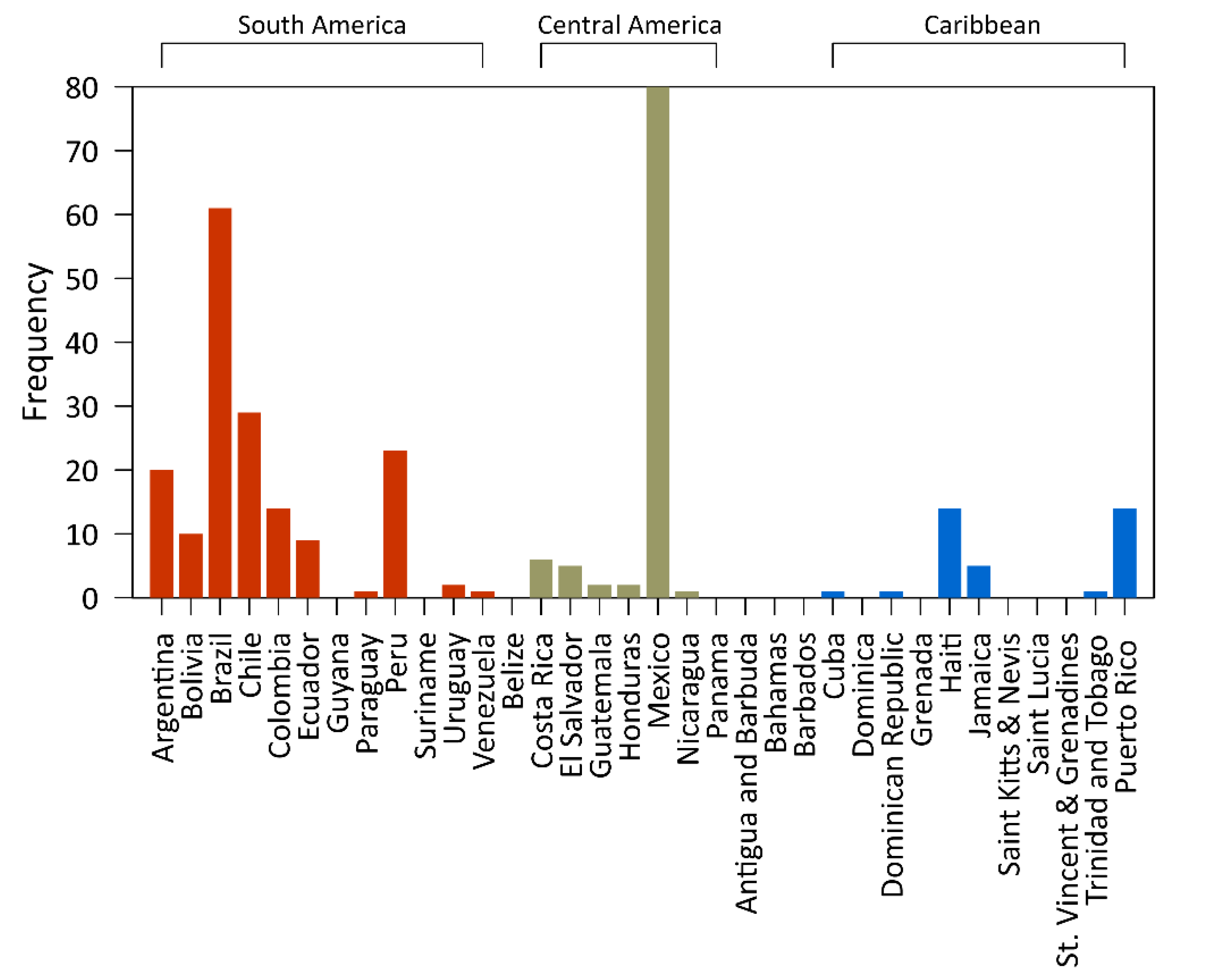
Applying the above-mentioned criteria to 302 flood-related research papers, 16% of the originally identified articles were selected for further analysis. Figure 1 depicts the geographical distribution of the selected articles. The analysis revealed that 21 LAC countries feature at least one peer-reviewed publication in English, implying that the remaining 12 countries did not publish any flood-related articles in any journal registered in the WoS database. In proportion, 71% of the countries feature two or more publications, and 29% feature only one publication. The countries with the largest number of published research papers are Mexico, Brazil, Chile, Peru, and Argentina (Table 1). Puerto Rico, on the other hand, boasts a record of 14 publications. As expected, Mexico and Brazil feature the most significant academic contributions to flood-related studies because of their greater territory and population (47% of the total). The top five countries collectively published 213 articles, representing 70% of the screened articles. The frequency distribution of the articles according to LAC country and region is shown in Figure A1.
In this study, publication growth represents the relative increase or decrease in the available statistics over a period. Unlike frequency, which only considered one aggregated period, the total time considered for the data collection was sliced into one-year time windows to calculate the growth of LAC’s flood-related publications. This approach was used to detect sudden bursts or declines by country, journal, and flood-related publications, since this could indicate major milestones or the discovery or failure of a research topic. The country publication growth indicated that most LAC countries intensified their flood-related research activities from 2010 onwards (e.g., Brazil, Chile and Peru, see Table 1).
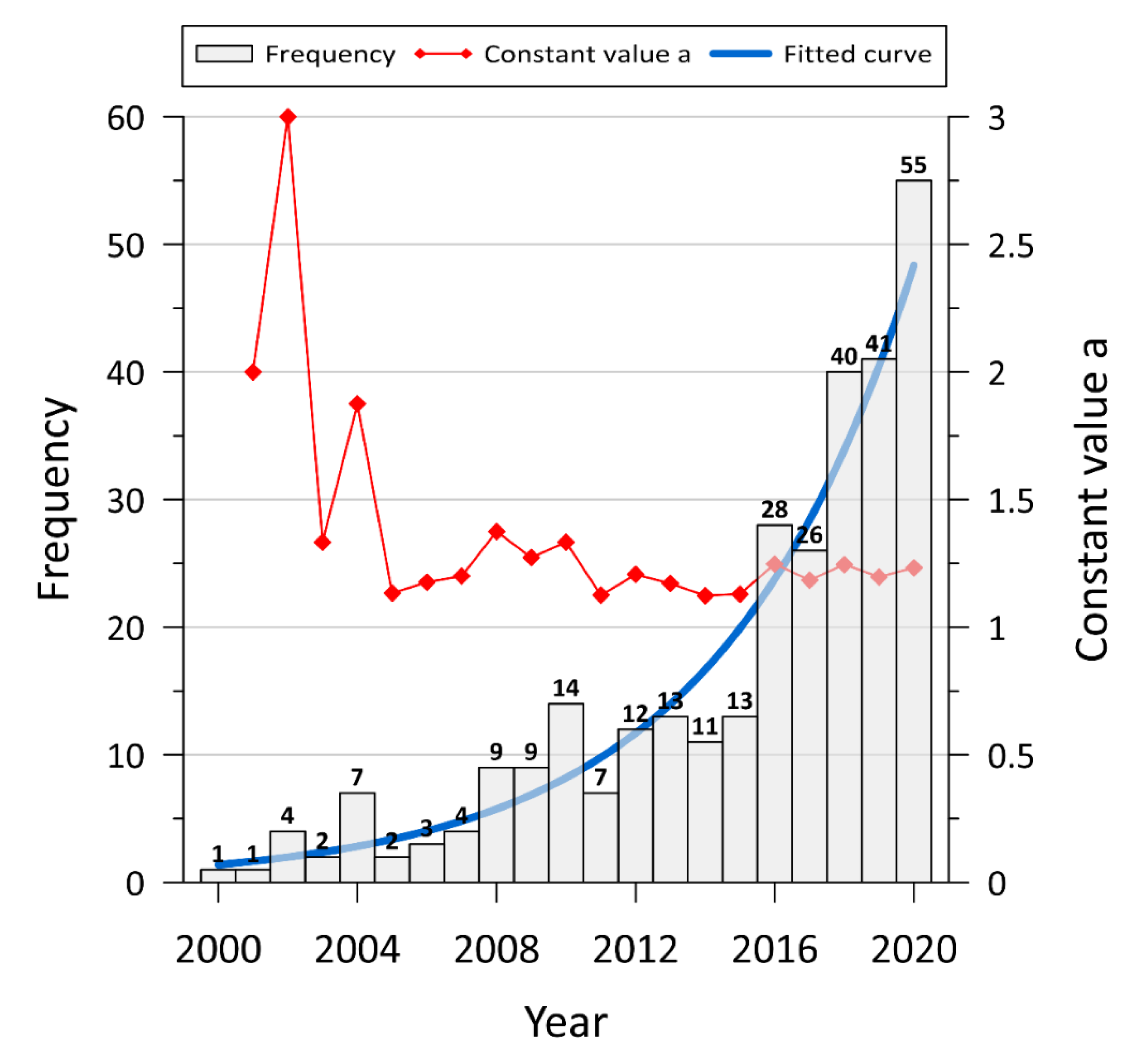
The annual frequency distribution of LAC flood-related articles published in WoS-registered journals is shown in Figure 2. The analyses of the temporal distribution of annual published articles highlight the degree of interest and development trends in flood hazard and risk assessment research and can serve as a baseline for evaluating the key topics of future research. Figure 2 shows that the number of articles published annually is rising, and the growth rate is increasing. The trend line for the period 2000–2020 fits an exponential curve and corresponds to the following equation: ln(Y) = 0.1774 × X−354.4870, with R2 equal to 0.52 (p-value ≤ 0.0001). The variable X in the equation represents the “n” year since 2000. If the current publication rate continues, the publication record of flood-related articles might reach 120 and ~300 in 2025 and 2030, respectively. Furthermore, the nonhomogeneous difference equation was used to characterize the development process of flood-related research papers published in WoS-registered journals in detail.
Based on the results, the period of interest (2000 to 2020) can be divided in the following three stages:
- (1)
- An initial period (2000–2005) with a variation between 1.13 and 3.00 (a = Nt/Nt-1 where t is the year, and Nt the cumulative number of published articles), accompanied by a large fluctuation, which was expected for the initial stage in this study.
- (2)
- A unimodal period (2006–2011) in which the fluctuation range was significantly reduced. It starts with a slow growth period from 1.18 to 1.38 and then decreases to 1.13.
- (3)
- A stable development period stretching from 2012 to 2020. In this period, the value of a is stable at about 1.19, and the variance is 0.002. This stage implies that research entered a stable development period, with scholars paying increased attention to this field. According to the identified trend, flood-related studies will remain a relevant topic, and it seems to have been triggered by the years major ENSO events are recorded (2002–2003, 2004–2005, 2009–2010, 2015–2016, and 2019 [15].
Various criteria were used for the classification of the consulted articles. First, the journals in which LAC researchers prefer to publish were identified (Table 2): Natural Hazards, Journal of Flood Risk Management, and Natural Hazards and Earth System Sciences, respectively. These journals comprise 18.5% of the total number of flood-related articles (302) published by LAC researchers in the 2000–2020 period. The top 10 journals in this domain represent 36%, and the remaining 64% are published in the 152 flood-related journals registered in WoS. The latter clearly indicates that the flood-related papers of LAC researchers are scattered across many scientific journals. However, the increase in publications in the top 10 journals over the past ten years reveals an increasing interest on the part of the LAC research community in publishing results in the most prestigious journals in the field.
LAC’s published flood-related articles also were classified according to their altitudinal range based on the Stadel [16] vertical zonification, considering four altitudinal classes, below 1000 m a.s.l. (A = hot zone), from 1000 to 2000 m a.s.l. (B = temperate zone), from 2000 to 4000 m a.s.l. (C = cold zone), and above 4000 m a.s.l. (D = glacial zone), respectively (Table 3). The latter combines the frost and snow zones, as specified in [16]. The survey revealed that 77% of the published articles consist of flood studies in the hot zone, coastal, and lowland or foothill areas (see Figure 1). As the elevation increases to 1000 m a.s.l. and beyond, a marked decrease in the number of articles is observed. Temperate zones correspond to areas of intermediate mountain slopes with altitudes below 2000 m a.sl., which represent 9% of the analysed articles, and ~11% of the articles deal with research in the high mountain areas in the cold zone. A lower number of flood-related articles are related to areas above 4000 m a.s.l. (~2% of total studies) and correspond to the highest mountain peaks and snow-capped mountain areas.
Keywords constitute an important feature of document retrieval, classification, topic search, and trend analysis, and they provide a glimpse of the article’s content. Several journals do not employ the keyword approach in their articles (e.g., Natural Hazards and Earth System Sciences and Journal of Hydrologic Engineering); as a result, 25 articles do not include keywords. In total, 865 different keywords were retrieved from 277 selected articles, among which 155 keywords (18%) possessed a frequency larger than 1. The highest number of identified keywords and the low frequency of most keywords reflect a high variety in the objectives and methods of the consulted articles. Table 4 lists the 10 most used keywords and, as expected, the keywords “flood/s” and “flooding” featured the highest frequency, but together accounted only for 4.3% of the total number of used keywords. Mexico was the third most frequently used keyword, which is in line with the highest number of Mexican flood-related articles encountered among the total of consulted articles. Overall, the most frequently used keywords were related to flood hazard, risk, and vulnerability in relation to climate change. Surprisingly, the seventh most frequently used keyword was related to “GLOF”, which stands for Glacial Lake Outburst Floods, which shows that a considerable number of articles are related to outburst floods caused by the dam failure of a glacial lake in the Andes mountain range. It must be noted that the 10 top keywords by frequency only represent 12.5% of the total number of keywords. In addition, the 4 most frequently used keywords, together with their frequency, after the top 10 keywords listed in Table 4, were Haiti (9), flood hazard/s (8), flood management (8), GIS (8; the acronym of Geographic Information Systems), and risk (8).
Table 5 and Table 6 depict the ranking of the consulted articles in terms of “the aim of the study” and “the method used”. Due to the variety in aims and methods, only the main objective and methodological classes were delineated using the diversity approach. Under this approach, the main aims and methods appearing in the scholarly articles of flood-related research domain are categorized into distinct groups using relevant categorization characteristics; i.e., they are classified from specific to general. A brief description of each class listed in the tables appears in the Annex of this article. Regarding the aim and the method of the study, the articles were classified into five “aim” classes (Table 5), and six “method” classes (Table 6). The objectives of most of the consulted articles (class 2 in Table 5) are related to flood hazards and risk assessment (67.7%). Of this class, 45% of the articles focus on flood risk assessment, 26% on flood hazard mapping, and 9% on historical flood reconstruction. The second most common aim of the surveyed articles relates to the social aspects of flooding (12.4%) with vulnerability assessment being the most frequently cited social aspect (44%). The major “aim” of the third class (class 5) relates to the statistical analysis of floods, representing 10.2% of the surveyed articles. In total, 66% of the articles of this class focus on the development and use of statistical flood forecasting methods. Regarding the methodology used, most published studies applied flood hazard modeling (class 2 in Table 6), from which 61% of the articles used hydraulic/hydrodynamic models. The next most frequent method class, class 6 in Table 6, indicates that 23% of the articles included the use of geographical information systems and remote sensing, where 71% used different remote sensing techniques. In the third method class, class 5, the focus of the articles on the use of statistical methods (11.6%) can be observed, 43% are related to multicriteria analysis and decision making.
4. Discussion
4.1. Countries
Half of the flood risk studies in LAC from 2000–2020 took place in Mexico or Brazil, while Chile, Peru, and Argentina completed the top country list, with a total of 70% of the 302 studies analysed in the 21 LAC countries. There is a disproportion in the production of articles among Latin American regions, with South America being the most productive, followed by Central America due to Mexico’s scientific production. In last place is the Caribbean, where 8 of the 14 countries did not produce any articles, and most of their scientific production relates to Haiti and Puerto Rico. Similar to our findings, Díez-Herrero and Garrote [17] stated that Mexico and Brazil are also the countries that produced the highest number of published papers on flood risk papers between 1995 and 2019. The seven LAC countries with no publications are the smallest countries, with the lowest incomes, in Central America. Nonetheless, Jongman et al. [1] indicated that Latin America is a region with higher rates of exposed population to river and coastal flood hazards.
Fang et al. [18] calculated the expected annual mortality risk of flood by country. Among the LAC countries Brazil is in the top 10% of countries, while Argentina, Mexico, Paraguay, Venezuela, Ecuador, Colombia, and Guatemala are among the top 10–35%. Peru, Chile, Uruguay, Bolivia, Nicaragua, and Cuba rank among the top 35–65% countries; Honduras, Haiti, Dominican Republic, and Costa Rica are in the top 65–90% country range; and Belize ranks in the bottom 90 to 100%. A similar country ranking is found based on the expected economic loss risk: Argentina and Brazil are in the top 10% class; Mexico, Venezuela, Colombia, Paraguay, Chile, and Ecuador are in the top 10–35% group of countries; Cuba, Guatemala, Peru, and Uruguay are in the top 35–65%; Bolivia, Nicaragua, Haiti, and Honduras are in the top 65–90%; and Costa Rica and Belize are in the top 90–100%).
Sun et al. [19] measured the expected annual rate of affected population risk of storm surge by country, where Mexico is in the top 10–35%; Belize, Honduras, and Dominica are in the top 35–65%; Haiti, Cuba, Saint Vincent and the Grenadines, and Grenada are in the top 65–90%; and Venezuela and Nicaragua are in the top 90–100%. In addition, with respect to the expected annual affected GDP (Gross Domestic Product) risk by storm surge, Mexico is in the 10–35% country range, whereas Antigua, Barbuda, Cuba, Saint Kitts, and Nevis are ranked in the top 35–65% country class; and the Dominican Republic, Honduras, Belize, and Dominica are in the top 65–90%. Our results are consistent with the global assessments placing Mexico, Brazil, Chile, Peru, and Argentina among the countries with the highest mortality, affected population, and annual economic loss risk due to flood and coastal storm surge risks. Furthermore, other countries of the region appear in these rankings due to their extensive flatlands (i.e., Paraguay, Uruguay, Venezuela), populated mountain floodplains (i.e., Colombia, Ecuador, Bolivia), or their climatic interaction with the Caribbean Sea (i.e., Cuba, Honduras, Costa Rica, and the Dominican Republic). The results reflect the spatial distribution trends found in this study and highlight the paramount importance of flood-related studies in LAC countries classified as vulnerable.
4.2. Annual Pattern
Extreme floods in the LAC region are likely to increase due to climate change and in line with the amplifying trend of flood disasters [20]. Hirabayashi et al. [2] identified an increased frequency of flood events coupled with the predicted climate change scenarios in the coming decades in LAC. The identified exponential increase in scientific articles on floods and hydrometeorological hazards is in line with previous findings by [17,21,22,23]. Emmer [21] discovered that climatic/hydro-meteorological hazards prevailed over geological/geomorphic hazards (56% vs. 44%) globally and that floods constitute the top individual type of hazard in terms of the total number of published research articles. In concordance with our trend, Gao and Ruan [22] determined a punctual increase in coastal flood publications after the 2010s. In accordance with our findings and the identified exponential trend, Borges Leal da Silva et al. [23] indicated that, worldwide, 75% of the papers published in the period 2010–2019 related to flood risk management were published after 2015. Similarly, and in line with our findings, in a flood risk bibliometric analysis for the period 1995 and 2019, Díez-Herrero and Garrote [17] found that an exponential growth of published papers was observed globally, primarily from 2010 onwards. Although an increase in flood-related studies is expected, this does not mean that the number of countries dealing with floods will increase; the current top-publishing countries will most probably produce more research papers.
4.3. Journals
The top five journals in which active LAC researchers in the field of flood risk-related topics publish are Natural Hazards, Journal of Flood Risk Management, Natural Hazards and Earth System Sciences, Water, and the Journal of Hydrology. The LAC articles in these journals constitute a total of 25% of the 302 analysed studies. Other flood-related journals in which LAC researchers publish, albeit to a lesser extent, are the Hydrological Sciences Journal, Sustainability, Geomorphology, Hydrological Processes, and the International Journal of Disaster Risk Reduction. These findings are in line with recent bibliometric studies; for example, according to Borges Leal da Silva et al. [23], the top journals used by LAC researchers in the field of flood risk and climate change are the journals Water, Natural Hazards, and the Journal of Hydrology and Sustainability. Surprisingly, our results matched significantly well with the observations of Díez-Herrero and Garrote [17]. The bibliometric analysis conducted by these authors showed that the top journals focused on flood risk are, respectively, Natural Hazards, Water, the Journal of Flood Risk Management, Natural Hazards and Earth System Sciences, the Journal of Hydrology, and the International Journal of Disaster Risk Reduction. Interestingly, the top 10 journals listed in Table 2 all rank in the Quartile 1 category. Moreover, as stated by Abbott [24], the articles from this category are trustworthy and influence readers far more than when an article is published in a journal with a weak or absent quality reputation. The latter poses an important problem since flood risk-related articles of LAC researchers are published in the lower-ranked journals registered in WoS. The rise of new and emerging WoS-registered journals, in which flood risk-related articles are published, is worrying since of these journals can be of questionable quality and are less appreciated by readers.
4.4. Altitude
The recent growth in the number of published articles by altitudinal zonification is in line with the rise in flood hazard and risk studies, which has become a key issue in lowlands since the beginning of the 21st century, followed by highlands; both are major zones of settlement density [16]. In line with expectations, the number of publications by Latin American researchers on flood-related topics are highest in the low-elevation coastal zone with its flat topography, dense population, and significant level of urbanization [25]. As projected by previous authors and Kulp and Straus [26], populations located in lowlands will increasingly be confronted with coastal flooding, supporting the need for an intensification of flood-related research in hot coastal zones [3]. Moreover, atmospheric rivers are critical systems for heavy precipitation and floods over littoral areas [14,15]. Only 23% of the surveyed flood-related LAC articles are oriented towards studies of areas with altitudes above 1000 m a.s.l. This tendency is not an excuse for not intensifying river flood studies at higher altitudes where populations are gathered along mountain floodplains (e.g., [27,28]). The potential for floods in highlands is realistic and often responsible for flooding at lower elevations. It is well known that steep topographies under intense rainfalls produce high-velocity discharges accompanied by the transport of sediments and debris, which often cause flooding in downstream valleys, where the human settlements and infrastructures are located [29,30]. Moreover, articles reporting flood studies in frost and above snow-line zones are mostly related to glacial lake outburst flood hazards, since they have recently been recognized for their catastrophic societal and geomorphic impact [31].
4.5. Keywords
Most of our top keywords were related to the term “flood”: flood/s, flooding, flash flood/s, flood risk, and GLOF. Moreover, “hazards”, “natural hazards”, “vulnerability”, and “climate change” were other frequently recurring keywords in the 277 analysed papers. Our results indicate that synonyms for the keyword “flood”, such as “overflow” or “heavy rainfall/precipitation”, are rarely used, whereas the term “extreme events” is more commonly used (six times). Borges Leal da Silva et al. [23] found similarities in used keywords in their global work, coinciding with vulnerability, climate change, and flood (urban-, risk, hazard). In terms of coastal flooding, Gao and Ruan [22] found many similarities with the top keywords we found, especially the keywords “flooding”, “climate change”, and “flood risk”. GLOF is a keyword increasingly used in studies on the outburst of glacier lakes in the high Andean mountain range [31]. The keywords that are used just once exhibit a huge heterogeneity, which results in scattered information that is difficult to manage. As stated by Bekhuis [32], if keywords are too broad or too narrow, they are useless. Adequate keywords enhance the discoverability of articles and increase the chances of being retrieved and promote the citation count. The use of adequate keywords has a direct impact on citation counts [33,34,35], and the selection of too-specific keywords negatively affects citation counts. These facts constitute a problem, since they reduce the visibility of the LAC flood-related research from recent last decades. To overcome this problem, authors should carefully select keywords that are linked to a well formulated title and abstract; i.e., the standardization of the three components, title, abstract, and keywords. should be coherent [36].
4.6. Aims and Methods
In LAC countries, as in many developing and tropical nations, flood baseline information is often scarce. Therefore, practical methodologies must be applied to efficiently support disaster risk assessment (e.g., [37,38,39,40]). Our bibliometric analysis indicates that in LAC, the most common flood risk-related studies are linked to hydrometeorological analyses; flood hazard and risk assessment; physiography, geomorphology and ecosystem approaches; social aspects, vulnerability, and resilience studies; statistical analyses; and GIS and remote sensing. These findings are in accordance with Díez-Herrero and Garrote [17], who split their flood risk factors into hazard (hydrologic-hydraulic; geosciences, and historical or paleo-hydrology), exposure (social and economic), vulnerability (social, economic, and analysis), and other (statistical analysis and GIS mapping). Furthermore, Borges Leal da Silva et al. [23] found that similar aims and methods are common in flood risk management and climate change studies, such as hazard and risk assessment, vulnerability assessment, statistical analyses, and GIS mapping. However, new research challenges are emerging, which are presented in the following section.
4.7. Perspectives for Flood Management
This review presents the knowledge generated to date from the scientific research in different regions of LAC, which is useful for identifying vulnerable countries that lack the resources to conduct research oriented towards combating floods. The review also provides insights to managers about the information’s location (journals and keywords) and which aspects (methodology and aim) are addressed for different vertical zonifications (i.e., altitudinal ranges). This will help to clearly identify the needs of each region respectively and provide a direction for decision making on issues related to flood management. Adaptation to floods will continue in LAC as scientific knowledge progresses; however, it is not possible to estimate how and to what extent this will take place in the different LAC countries. Nevertheless, it is inevitable that settlements in floodplains will face the risk of flooding. The adoption of structural measures vs. non-structural measures [41,42] that are a function of policies and the economy (low-income to high-income countries), together with a prospective view of future climatic conditions, are needed to assess flood risk and prepare for mitigation and adaptation measures. Therefore, this review offers, to politicians and water authorities, a basis for the formulation of adequate policies and measures that promote the production of scientific flood research to prevent and counter the destructive effects of floods in a climate change context across LAC.
5. Conclusions
Based on the conducted bibliographic analysis, it is expected that the number of flood risk studies and research papers will further increase, and that this process will be accelerated by the imperative need for climate change adaptation. according to our understanding of the publication evolution and progress in the period 2000–2020, countries such as Mexico, Brazil, Chile, Peru, and Argentina will continue to lead research around flood risk assessment and the delineation of policies and management strategies to temper the destructive effects of flooding. In addition, the research community should encourage the development of flood risk studies in emerging flood areas such as Costa Rica, Dominican Republic, Haiti, Puerto Rico, Colombia, and Ecuador. It is compulsory to promote and increase flood risk scientific research in the entire LAC region, with specific attention to less developed countries. Moreover, the academic community of the Latin American and Caribbean countries might keep publishing flood-related research findings in a limited number of specialized journals, such as Natural Hazards, the Journal of Flood Risk Management Natural Hazards and Earth System Sciences, Water, the Journal of Hydrology, Hydrological Sciences Journal, Sustainability, Geomorphology, Hydrological Processes, and the International Journal of Disaster Risk Reduction. Parallel to this, a growing acceptance of open-access initiatives sponsored by universities, public, private, and funding institutions will take place.
The presented bibliographic analysis clearly reveals the prevailing trends in LAC’s flood-related research, highlighting the predominant ongoing research based on keywords, aims and methods, altitude, and reviews of the pattern of publication by country. Although the majority of publications in LAC are mostly associated with hydrometeorological analysis, flood hazard/risk assessments, physiographic/geomorphological/and ecosystem approaches, vulnerability and resilience studies, statistical analyses, and GIS/remote sensing methods, we noticed some important gaps as well as new, emerging topics that need to be addressed or expanded in the coming years. In conclusion, we suggest five emerging directions for future flood-related research in LAC: (1) Intensification of the use of machine learning approaches and new satellite imagery products to improve flood prediction and flood early warning systems; (2) Research with a focus on the standardization of post-flood data collection for model validation; (3) Identification of the role vegetation plays in flood episodes; (4) Search for adequate and cost-benefit structural and non-structural flood protection policies and measures; and (5) Analysis of the interaction and effects when flooding occurs at different locations in river networks simultaneously. Based on past and present research, it is to be expected that the flood-related research community in LAC will develop flood risk reduction solutions in a timely manner.
Author Contributions
Conceptualization, J.P.; methodology, J.P.; software, J.P.; validation, J.P. and A.Q.-R.; formal analysis, J.P. and A.Q.-R.; investigation, J.P. and A.Q.-R.; resources, J.P. and A.Q.-R.; data curation, J.P. and A.Q.-R.; writing—original draft preparation, J.P. and A.Q.-R.; writing—review and editing, J.P. and A.Q.-R.; visualization, J.P.; project administration, J.P. and A.Q.-R. All authors have read and agreed to the published version of the manuscript.
Funding
This research received no external funding.
Data Availability Statement
The data presented in this study are available on request from the corresponding author.
Acknowledgments
Juan Pinos was the beneficiary of an FPI grant (BES-2017-082234) funded by the Spanish Ministry of Science and Innovation. Thanks to Hugo Rodríguez-Bolaños from the University of Costa Rica who assisted in the bibliometric process. Special thanks to Soll Kracher for the English grammar and syntax revision.
Conflicts of Interest
The authors declare no conflict of interest.
Appendix A
Figure A1.
Bar chart of the frequency count of flood-related articles published in WoS-registered journals by LAC country and region.
Figure A1.
Bar chart of the frequency count of flood-related articles published in WoS-registered journals by LAC country and region.
Aim classes description:
- Evaluate climate and rainfall attributes: Trends in precipitation extremes and characteristics due to climate change (e.g., frequency analysis of rainfall, climate models).
- Flood hazard and risk assessment: Identify areas/assets at risk of flooding, and consequently to improve flood risk management and disaster prevention (e.g., flood mapping, develop a flood risk methodology).
- Evaluate physiography, geomorphology, and ecosystem functioning: Determine changes in landscape functionating (e.g., assess the influence of different land use and land cover, dynamics of floodplain environments).
- Social aspects, vulnerability and resilience: People behaviour and dynamics in flooding events (e.g., measure perceptions of flooding and resilience to flooding by context, gender and time, develop a vulnerability index).
- Statistical analysis: Identify trends by applying statistical methods (e.g., flood uncertainty, flood reconstruction).
Method classes description with examples:
- Climatological and hydrometeorological analysis: (e.g., standardized precipitation index, object-based rainfall analysis, historical climatology analysis).
- Flood hazard modelling and risk assessment: (e.g., flood hydrodynamic modelling, flood loss models).
- Physiographic, geomorphologic, and ecosystem functioning analysis: (e.g., land morphology mapping, paleotempestology, space-time analysis of land-use changes).
- Social assessment, vulnerability and resilience analysis: (e.g., vulnerability estimation by bivariate correlations, resilience index, semi-structured interviews, qualitative case study approach).
- Statistical methods: (e.g., multicriteria analysis, fractal analysis, generalized likelihood uncertainty estimation).
- GIS and remote sensing: (e.g., topographic map, satellite imagery, ArcGIS, digital elevations models).
References
- Jongman, B.; Ward, P.J.; Aerts, J.C. Global exposure to river and coastal flooding: Long term trends and changes. Glob. Environ. Change 2012, 22, 823–835. [Google Scholar] [CrossRef]
- Hirabayashi, Y.; Tanoue, M.; Sasaki, O.; Zhou, X.; Yamazaki, D. Global exposure to flooding from the new CMIP6 climate model projections. Sci. Rep. 2021, 11, 3740. [Google Scholar] [CrossRef]
- Tellman, B.; Sullivan, J.A.; Kuhn, C.; Kettner, A.J.; Doyle, C.S.; Brakenridge, G.R.; Slayback, D.A. Satellite imaging reveals increased proportion of population exposed to floods. Nature 2021, 596, 80–86. [Google Scholar] [CrossRef] [PubMed]
- Alfieri, L.; Bisselink, B.; Dottori, F.; Naumann, G.; de Roo, A.; Salamon, P.; Feyen, L. Global projections of river flood risk in a warmer world. Earth’s Future 2017, 5, 171–182. [Google Scholar] [CrossRef]
- Dottori, F.; Szewczyk, W.; Ciscar, J.C.; Zhao, F.; Alfieri, L.; Hirabayashi, Y.; Feyen, L. Increased human and economic losses from river flooding with anthropogenic warming. Nat. Clim. Change 2018, 8, 781–786. [Google Scholar] [CrossRef]
- Sandoval, V.; Sarmiento, J.P. A neglected issue: Informal settlements, urban development, and disaster risk reduction in Latin America and the Caribbean. Dis. Prev. Manag. 2020, 29, 731–745. [Google Scholar] [CrossRef]
- Cai, W.; McPhaden, M.J.; Grimm, A.M.; Rodrigues, R.R.; Taschetto, A.S.; Garreaud, R.D.; Vera, C. Climate impacts of the El Niño–southern oscillation on South America. Nat. Rev. Earth Environ. 2020, 1, 215–231. [Google Scholar] [CrossRef]
- Glantz, M.H.; Ramirez, I.J. Reviewing the Oceanic Niño Index (ONI) to enhance societal readiness for El Niño’s impacts. Int. J. Dis. Risk Sci. 2020, 11, 394–403. [Google Scholar] [CrossRef]
- Hidalgo, H.G.; Amador, J.A.; Alfaro, E.J.; Quesada, B. Hydrological climate change projections for Central America. J. Hydrol. 2013, 495, 94–112. [Google Scholar] [CrossRef]
- Reguero, B.G.; Losada, I.J.; Diaz-Simal, P.; Mendez, F.J.; Beck, M.W. Effects of climate change on exposure to coastal flooding in Latin America and the Caribbean. PLoS ONE 2015, 10, e0133409. [Google Scholar] [CrossRef]
- Campos-Durán, D.; Quesada-Román, A. Riesgos intensivos y extensivos en América Central entre 1990 y 2015. Anuá. Inst. Geoci. 2017, 40, 234–249. [Google Scholar] [CrossRef]
- Guevara-Murua, A.; Williams, C.A.; Hendy, E.J.; Imbach, P. 300 years of hydrological records and societal responses to droughts and floods on the Pacific coast of Central America. Clim. Past 2018, 14, 175–191. [Google Scholar] [CrossRef] [Green Version]
- Viale, M.; Valenzuela, R.; Garreaud, R.D.; Ralph, F.M. Impacts of atmospheric rivers on precipitation in southern South America. J. Hydrometeorol. 2018, 19, 1671–1687. [Google Scholar] [CrossRef]
- Zhang, Z.; Ralph, F.M.; Zheng, M. The relationship between extratropical cyclone strength and atmospheric river intensity and position. Geophys. Res. Lett. 2019, 46, 1814–1823. [Google Scholar] [CrossRef]
- CPC-Climate Prediction Center. El Niño/Southern Oscillation (ENSO). National Oceanic and Atmospheric Administration (NOAA), National Weather Service (NWS), College Park, MD, USA, 2021. Available online: https://origin.cpc.ncep.noaa.gov/products/analysis_monitoring/ensostuff/ONI_v5.php (accessed on 18 October 2021).
- Stadel, C. Altitudinal belts in the tropical Andes: Their ecology and human utilization. In Yearbook (Conference of Latin Americanist Geographers), Auburn, AL, USA; University of Texas Press: Austin, TX, USA, 1990; pp. 45–60. Available online: https://www.jstor.org/stable/25765738 (accessed on 10 July 2021).
- Díez-Herrero, A.; Garrote, J. Flood risk analysis and assessment, applications and uncertainties: A bibliometric review. Water 2020, 12, 2050. [Google Scholar] [CrossRef]
- Fang, J.; Li, M.; Shi, P. Mapping Flood Risk of the World. In World Atlas of Natural Disaster Risk; Shi, P., Kasperson, R., Eds.; Springer: Berlin/Heidelberg, Germany, 2015. [Google Scholar] [CrossRef]
- Sun, S.; Fang, J.; Shi, P. Mapping Storm Surge Risk of the World. In World Atlas of Natural Disaster Risk; Shi, P., Kasperson, R., Eds.; Springer: Berlin/Heidelberg, Germany, 2015. [Google Scholar] [CrossRef]
- IPCC. Global Warming of 1.5 °C. An IPCC Special Report on the Impacts of Global Warming of 1.5 °C Above Pre-Industrial Levels and Related Global Greenhouse Gas Emission Pathways, in the Context of Strengthening the Global Response to the Threat of Climate Change, Sustainable Development, and Efforts to Eradicate Poverty. 2014. Available online: https://www.ipcc.ch/sr15/ (accessed on 22 June 2021).
- Emmer, A. Geographies and scientometrics of research on natural hazards. Geosciences 2018, 8, 382. [Google Scholar] [CrossRef] [Green Version]
- Gao, C.; Ruan, T. Bibliometric analysis of global research progress on coastal flooding 1995–2016. Chin. Geogr. Sci. 2018, 28, 998–1008. [Google Scholar] [CrossRef] [Green Version]
- Borges Leal da Silva, L.; Alencar, M.H.; de Almeida, A.T. Multidimensional flood risk management under climate changes: Bibliometric analysis, trends and strategic guidelines for decision-making in urban dynamics. Int. J. Disaster Risk Reduct. 2020, 50, 101865. [Google Scholar] [CrossRef]
- Abbott, J.H. How to choose where to publish your work. J. Orthop. Sports Phys. Ther. 2017, 47, 6–10. [Google Scholar] [CrossRef] [Green Version]
- Neumann, B.; Vafeidis, A.T.; Zimmermann, J.; Nicholls, R.J. Future coastal population growth and exposure to sea-level rise and coastal flooding-a global assessment. PLoS ONE 2015, 10, e0118571. [Google Scholar] [CrossRef] [PubMed] [Green Version]
- Kulp, S.A.; Strauss, B.H. New elevation data triple estimates of global vulnerability to sea-level rise and coastal flooding. Nat. Comm. 2019, 10, 4844. [Google Scholar] [CrossRef] [PubMed] [Green Version]
- Pinos, J.; Timbe, L.; Timbe, E. Evaluation of 1D hydraulic models for the simulation of mountain fluvial floods: A case study of the Santa Bárbara River in Ecuador. Water Pract. Technol. 2019, 14, 341–354. [Google Scholar] [CrossRef]
- Quesada-Román, A.; Ballesteros-Cánovas, J.A.; Granados-Bolaños, S.; Birkel, C.; Stoffel, M. Improving regional flood risk assessment using flood frequency and dendrogeomorphic analyses in mountain catchments impacted by tropical cyclones. Geomorphology 2022, 396, 108000. [Google Scholar] [CrossRef]
- Pinos, J.; Timbe, L. Mountain riverine floods in Ecuador: Issues, challenges, and opportunities. Front. Water 2020, 2, 36. [Google Scholar] [CrossRef]
- Stoffel, M.; Wyżga, B.; Marston, R.A. Floods in mountain environments: A synthesis. Geomorphology 2016, 272, 1–9. [Google Scholar] [CrossRef]
- Veettil, B.K.; Kamp, U. Glacial lakes in the Andes under a changing climate: A review. J. Earth Sci. 2021, 32, 1575–1593. [Google Scholar] [CrossRef]
- Bekhuis, T. Keywords, discoverability, and impact. J. Med. Libr. Assoc. 2015, 103, 119. [Google Scholar] [CrossRef] [Green Version]
- Uddin, S.; Khan, A. The impact of author-selected keywords on citation counts. J. Informetr. 2016, 10, 1166–1177. [Google Scholar] [CrossRef]
- Herrera-Franco, G.; Montalván-Burbano, N.; Carrión-Mero, P.; Bravo-Montero, L. Worldwide Research on Socio-Hydrology: A Bibliometric Analysis. Water 2021, 13, 1283. [Google Scholar] [CrossRef]
- Carrión-Mero, P.; Montalván-Burbano, N.; Morante-Carballo, F.; Quesada-Román, A.; Apolo-Masache, B. Worldwide research trends in landslide science. Int. J. Environ. Res. Public Health 2021, 18, 9445. [Google Scholar] [CrossRef]
- Martinsson, A. A coherent philosophy of titles, abstracts and keywords in scientific articles. In Scientific Information Transfer: The Editor’s Role; Balaban, M., Ed.; Springer: Dordrecht, The Netherlands, 1978. [Google Scholar] [CrossRef]
- Pinos, J.; Orellana, D.; Timbe, L. Assessment of microscale economic flood losses in urban and agricultural areas: Case study of the Santa Bárbara River, Ecuador. Nat. Hazards 2020, 103, 2323–2337. [Google Scholar] [CrossRef]
- Quesada-Román, A.; Villalobos-Chacón, A. Flash flood impacts of Hurricane Otto and hydrometeorological risk mapping in Costa Rica. Geogr. Tidsskr. 2020, 120, 142–155. [Google Scholar] [CrossRef]
- García-Soriano, D.; Quesada-Román, A.; Zamorano-Orozco, J.J. Geomorphological hazards susceptibility in high-density urban areas: A case study of Mexico City. J. S. Am. Earth Sci. 2020, 102, 102667. [Google Scholar] [CrossRef]
- Quesada-Román, A.; Villalobos-Portilla, E.; Campos-Durán, D. Hydrometeorological disasters in urban areas of Costa Rica, Central America. Environ. Hazards 2021, 20, 264–278. [Google Scholar] [CrossRef]
- Thampapillai, D.J.; Musgrave, W.F. Flood damage mitigation: A review of structural and nonstructural measures and alternative decision frameworks. Water Resour. Res. 1985, 21, 411–424. [Google Scholar] [CrossRef]
- Schanze, J.; Hutter, G.; Offert, A.; Penning-Rowsell, E.C.; Parker, D.; Harries, T.; Werritty, A.; Nachtnebel, H.-P.; Holzmann, H.; Neuhold, C.; et al. Systematisation, Evaluation and Context Conditions of Structural and Non-Structural Measures for Flood Risk Reduction. (CRUE Research report; No. I-1). CRUE Funding Initiative on Flood Risk Management Research. 2008. Available online: http://www.flood-era.ioer.de/files/FLOOD-ERA_Final_report.pdf (accessed on 9 December 2021).
Figure 1.
Spatial coverage (red dots) of LAC flood-related research papers published in WoS registered journals. Altitude in meters above sea level.
Figure 1.
Spatial coverage (red dots) of LAC flood-related research papers published in WoS registered journals. Altitude in meters above sea level.
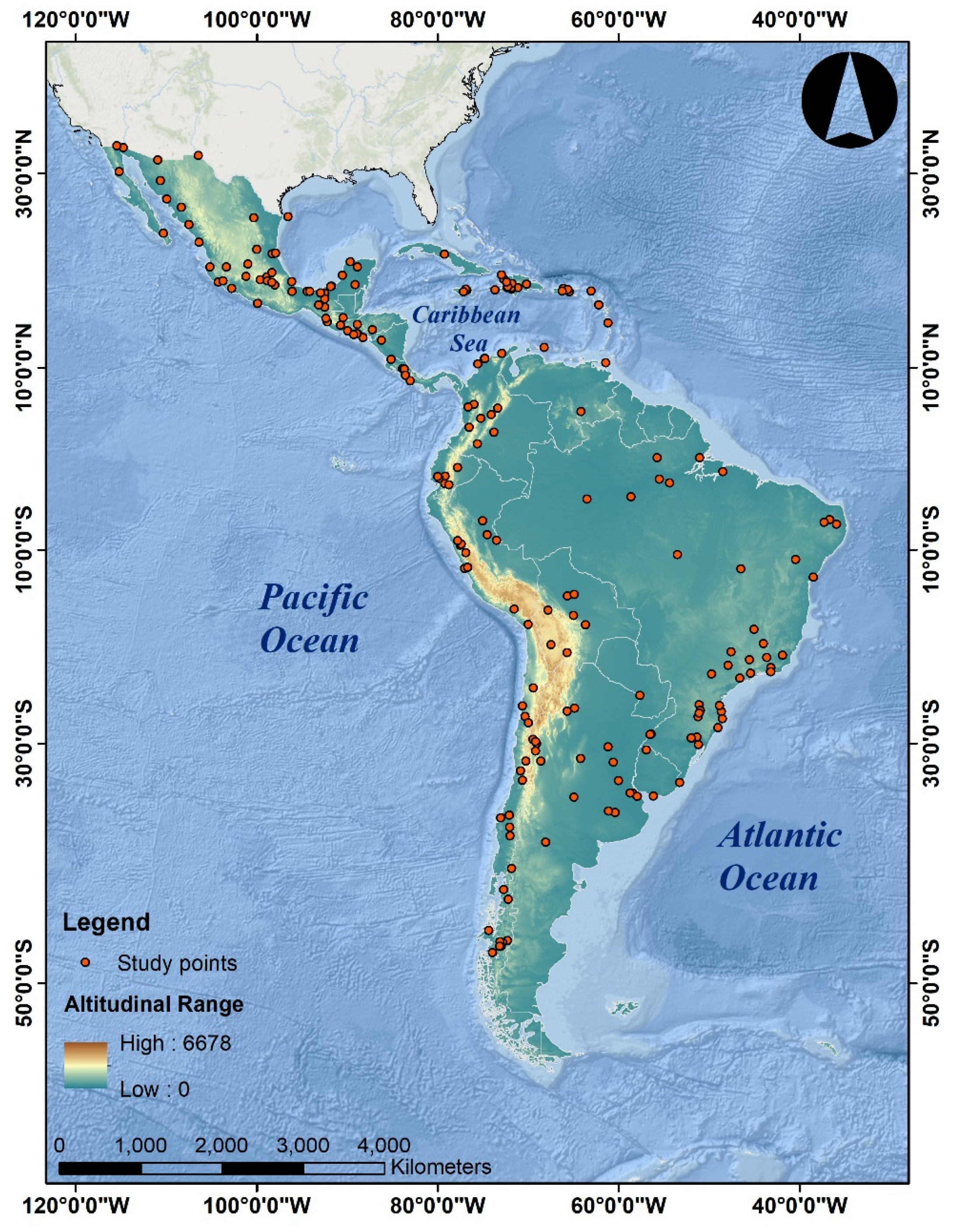
Figure 2.
Annual frequency distribution of LAC flood-related articles published in WoS-registered journals.
Figure 2.
Annual frequency distribution of LAC flood-related articles published in WoS-registered journals.


Table 1.
Record and growth of flood-related publications in WoS journals of the top five leading LAC countries.
Table 1.
Record and growth of flood-related publications in WoS journals of the top five leading LAC countries.
| Country | No. of Studies | Percentage | 2000–2020 |
|---|---|---|---|
| Mexico | 80 | 26.5 |  |
| Brazil | 61 | 20.2 |  |
| Chile | 29 | 9.6 |  |
| Peru | 23 | 7.6 |  |
| Argentina | 20 | 6.6 |  |
Note: Red colour for no record and blue for existence.
Table 2.
LAC’s publication record and growth of flood-related articles in the top 10 journals in the period 2000–2020.
Table 2.
LAC’s publication record and growth of flood-related articles in the top 10 journals in the period 2000–2020.
| Journal | No. of Studies | Percentage | 2000–2020 |
|---|---|---|---|
| Natural Hazards | 27 | 8.9 |  |
| Journal of Flood Risk Management | 16 | 5.3 |  |
| Natural Hazards and Earth System Sciences | 13 | 4.3 |  |
| Water | 12 | 4.0 |  |
| Journal of Hydrology | 9 | 3.0 |  |
| Hydrological Sciences Journal | 8 | 2.6 |  |
| Sustainability | 8 | 2.6 |  |
| Geomorphology | 5 | 1.6 |  |
| Hydrological Processes | 5 | 1.6 |  |
| International Journal of Disaster Risk Reduction | 5 | 1.6 |  |
Note: Red colour for no record and blue for existence.
Table 3.
LAC’s flood-related articles ranked according to the altitudinal range of the study area and its growth.
Table 3.
LAC’s flood-related articles ranked according to the altitudinal range of the study area and its growth.
| Altitudinal Range | Climatic Zone | Class | No. of Studies | Percentage | 2000–2020 |
|---|---|---|---|---|---|
| 0–1000 | Hot zone | A | 232 | 76.8 |  |
| 1000–2000 | Temperate zone | B | 28 | 9.2 |  |
| 2000–4000 | Cold zone | C | 35 | 11.5 |  |
| >4000 | Glacial zone | D | 7 | 2.3 |  |
Note: Red colour for no record and blue for existence.
Table 4.
Ranking of the top-10 keywords in LAC’s flood-related articles published in the period 2000–2020. GLOF: Glacial Lake Outburst Floods.
Table 4.
Ranking of the top-10 keywords in LAC’s flood-related articles published in the period 2000–2020. GLOF: Glacial Lake Outburst Floods.
| Keywords | Frequency | Percentage | Cumulative Percentage |
|---|---|---|---|
| Flood/s | 37 | 2.8 | 2.8 |
| Flooding | 20 | 1.5 | 4.3 |
| Mexico | 20 | 1.5 | 5.8 |
| Flash flood/s | 16 | 1.2 | 7.0 |
| Vulnerability | 16 | 1.2 | 8.2 |
| Flood risk | 15 | 1.1 | 9.3 |
| GLOF | 12 | 0.9 | 10.2 |
| Climate change | 11 | 0.8 | 11.0 |
| Natural Hazard/s | 11 | 0.8 | 11.8 |
| Hazard/s | 10 | 0.7 | 12.5 |
Table 5.
Ranking of the surveyed articles based on the aim of the study.
| Class | Aim | No. of Studies * | Percentage |
|---|---|---|---|
| 1 | Evaluate climate and rainfall attributes | 12 | 3.8 |
| 2 | Flood hazard and risk assessment | 213 | 67.6 |
| 3 | Evaluate physiography, geomorphology, and ecosystem functioning | 19 | 6.0 |
| 4 | Social aspects, vulnerability, and resilience | 39 | 12.4 |
| 5 | Statistical analysis | 32 | 10.2 |
* The total number of studies is higher since certain articles may feature aims in two different classes.
Table 6.
Ranking of the surveyed articles based on the methodology used.
| Class | Method | No. of Studies * | Percentage |
|---|---|---|---|
| 1 | Climatological and hydrometeorological analysis | 16 | 5.0 |
| 2 | Flood hazard modelling and risk assessment | 123 | 38.7 |
| 3 | Physiographical, geomorphological and ecosystem functioning analysis | 35 | 11.0 |
| 4 | Social assessment, vulnerability and resilience analysis | 34 | 10.7 |
| 5 | Statistical methods | 37 | 11.6 |
| 6 | GIS and remote sensing | 73 | 23.0 |
* The total number of studies is higher since certain articles may feature methods in two different classes.
Publisher’s Note: MDPI stays neutral with regard to jurisdictional claims in published maps and institutional affiliations. |
© 2021 by the authors. Licensee MDPI, Basel, Switzerland. This article is an open access article distributed under the terms and conditions of the Creative Commons Attribution (CC BY) license (https://creativecommons.org/licenses/by/4.0/).
Share and Cite
MDPI and ACS Style
Pinos, J.; Quesada-Román, A. Flood Risk-Related Research Trends in Latin America and the Caribbean. Water 2022, 14, 10. https://doi.org/10.3390/w14010010
AMA Style
Pinos J, Quesada-Román A. Flood Risk-Related Research Trends in Latin America and the Caribbean. Water. 2022; 14(1):10. https://doi.org/10.3390/w14010010
Chicago/Turabian StylePinos, Juan, and Adolfo Quesada-Román. 2022. "Flood Risk-Related Research Trends in Latin America and the Caribbean" Water 14, no. 1: 10. https://doi.org/10.3390/w14010010
Note that from the first issue of 2016, this journal uses article numbers instead of page numbers. See further details here.