
Framework of Emergency Response System for Potential Large-Scale Landslide in Taiwan
by
Yuan-Jung Tsai
1,*, 
Fang-Tsz Syu
1,
Chjeng-Lun Shieh
1,
Chi-Rong Chung
2,
Shih-Shu Lin
2 and
Hsiao-Yuan Yin
2 1
Disaster Prevention Research Center, National Cheng-Kung University, Tainan 709, Taiwan
2
Soil and Water Conservation Bureau, Council of Agriculture, Nantou 540, Taiwan
*
Author to whom correspondence should be addressed.
Water 2021, 13(5), 712; https://doi.org/10.3390/w13050712
Submission received: 30 December 2020
/
Revised: 2 March 2021
/
Accepted: 3 March 2021
/
Published: 5 March 2021
(This article belongs to the Special Issue Rainfall-Induced Shallow Landslides Modeling and Warning)
Abstract
:In order to lower the risks of large-scale landslides and improve community resilience in Taiwan, a long-term project has been promoted by the Soil and Water Conservation Bureau since 2017. In this study, methods to build an emergency response framework including hazard mapping and early warning system establishment were introduced. For hazard mapping, large-scale landslides were categorized into a landslide, debris flow, or landslide dam type based on the movement of unstable materials and topography. Each disaster type has different hazard zone delineation methods to identify the affected areas. After establishing the possible effected areas, early warning mechanisms, including warning value using rainfall as the indicator and evacuation procedures, should be created for emergency response. To set the warning value, analysis of the occurrence thresholds of previous existing large-scale landslides was conducted to determine the critical rainfall and further utilized to set the warning value considering the evacuation time for the locals. Finally, for integration with the current debris flow emergency response system, potential large-scale landslide areas were further divided into two types based on their spatial relationship with debris flows. For those overlapping with existing debris flow protected targets, the current emergency response system was upgraded considering the impact of large-scale landslides, while the others were suggested for use in building a new emergency response procedure. This integrated framework could provide a feasible risk avoidance method for local government and residents.
1. Introduction
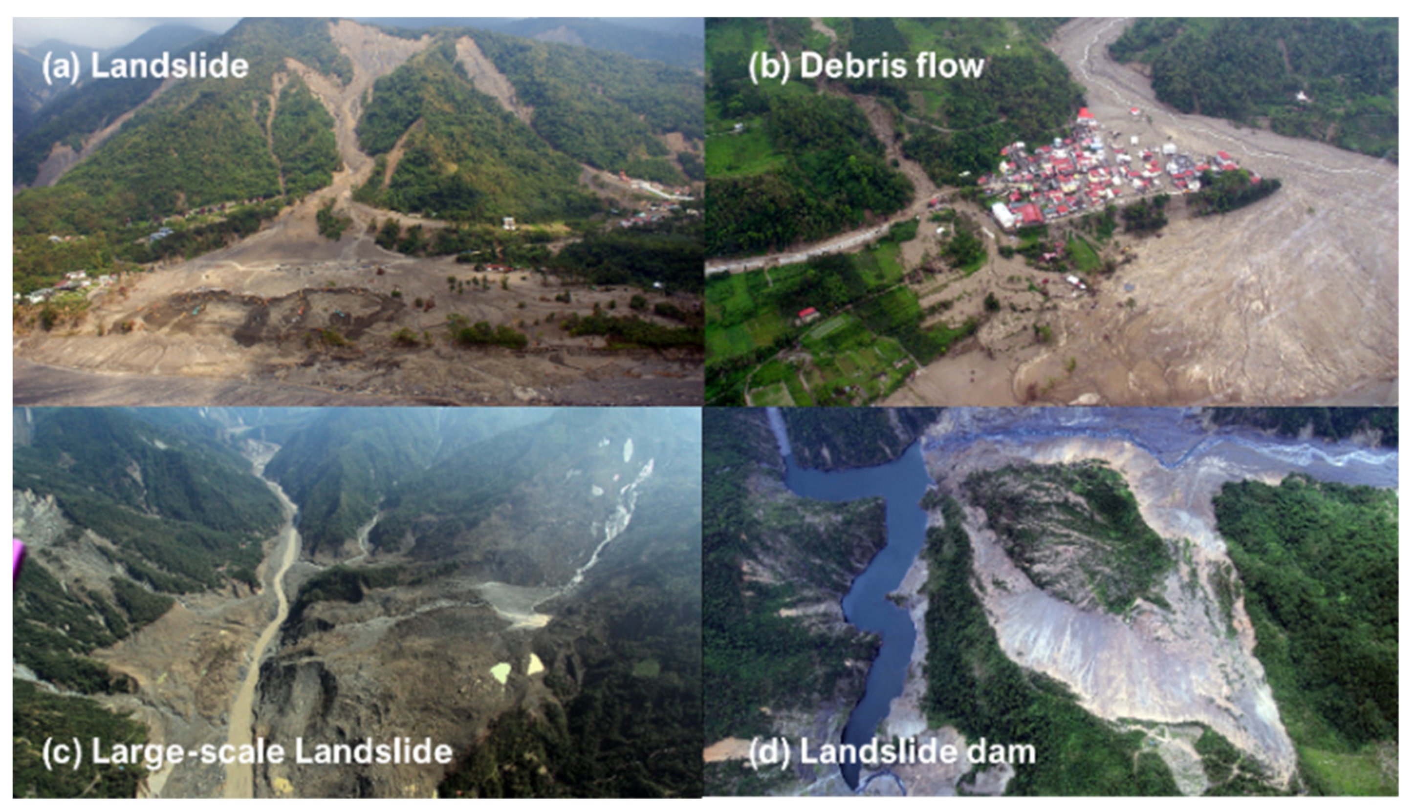
Landslide disasters have happened frequently under climate change, causing serious property losses and casualties. High-risk/low-frequency events like large-scale landslides have become more common internationally under extreme climate such as the disasters in Kii Peninsula in Japan, 2011 [1], and the Oso landslide in the U.S., 2014 [2]. In 2009, Typhoon Morakot, with more than 3000 mm rainfall, induced one of the most serious disasters in the history of Taiwan. As shown in Figure 1, various landslide disasters, such as shallow landslides, debris flows, large-scale landslides, and landslide dams, occurred during the typhoon and caused hundreds of deaths [3,4].
Among all the disasters induced by Typhoon Morakot, Hsiaolin Village was attacked by a large-scale landslide causing more than 400 casualties, and half of the village was ruined. Many experts have dedicated efforts to determining the triggering factors of the large-scale landslide [5,6,7,8]. According to the previous research, deep-seated gravitational slope deformation was the pivotal cause, leading to a large quantity of slope materials becoming unstable over a short time. Post-disaster recovery was a great challenge as the large-scale landslide had not only devastated the village but also paralyzed local infrastructures and access roads.
The current disaster response systems are not sufficient to cope with escalated sediment disasters. Reinforced disaster prevention and mitigation frameworks have been discussed and proposed in many countries. In Japan, hazard zone delineation and structural countermeasures are applied to potential large-scale landslides [9]. In the U.S., a landslide preparedness act was signed in 2021 to adapt to landslide hazard and risk and improve emergency response systems [10]. In Taiwan, after Typhoon Morakot, the government has engaged in a series of disaster prevention and mitigation projects (Figure 2) to establish a risk classification system for identified potential landslide areas and clarify their risk levels for future disaster prevention and mitigation strategies. Among all the projects, the Soil and Water Conservation Bureau proposed a 10-year plan, “Large-scale landslide disaster prevention and mitigation under climate change”, in 2016 [11].
Identifying and investigating potential large-scale landslides was the first step in establishing an emergency response system. High-resolution terrain data (1 or 2 m) from Airborne LiDAR were used to identify the location and scale of potential large-scale landslide areas [12,13] falling into one of the following features: area greater than 10 hectares, depth of more than 10 m, or volume larger than 106 cubic meters. More than 9000 potential large-scale landslide sites with sliding characteristics were identified. Considering the number of areas, priority should be put on those locations with obvious moving activities or protected targets.
Risk analysis should be conducted considering occurrence degrees, activity index, and protected targets. Occurrence degrees, evaluated by geological and topographical conditions, represent the inherent causes of potential large-scale landslides. This index was developed by analyzing correlation factors of existing landslide cases [14]. Activity index, evaluated by surface deformation, describes the potential large-scale landslide variation after rainfall or earthquake events. The index was quantified based on synthetic aperture radar analysis [15] to evaluate the variation of slope surface. Protected targets, such as traffic routes, houses, and infrastructures, quantify the potential losses if large-scale landslides occur. For risk grading, a risk matrix is used. Occurrence degrees and activity index are used as the frequency axis, and protected targets are used as the consequence axis.
After the risk analysis, structural and nonstructural countermeasures could be applied to reduce the risk of potential large-scale landslides. Once a large-scale landslide occurs, the large amount of material far exceeds the processing capacity of engineering countermeasures. Hence, software countermeasures including hazard mapping, warning systems, and evacuation plans have become more important for risk reduction.
According to the experiences of the U.S. and Japan, when facing a high-risk/low-frequency disaster like large-scale landslide, distancing from hazard zones is more feasible in risk management. Hence, the purpose of this research was to propose nonstructural methods for large-scale landslides risk reduction including hazard mapping, a pre-warning system, and a response system framework that involves alerting and evacuating locals.
2. Hazard Mapping for Large-Scale Landslide Disasters
2.1. Disasters Caused by Large-Scale Landslides
Serious disasters caused by large-scale landslides can destroy an entire village including local shelters, and the chance to escape or be rescued is relatively low considering the scale of the disaster. Therefore, it is necessary to determine the hazard zones and the scope of the large-scale landslides.
When a large-scale landslide occurs, a large amount of material will move along the sliding direction and begin to accumulate in an area with a gentle slope [9]. If the material stops at a gentle slope or flat area, the deposition will be cone-shaped (Figure 3a). When the material enters a steep stream, the material will still be unstable and will evolve in the form of debris flow if the morphological features are sufficient for generating flow conditions (Figure 3b). If the slope of the river being invaded is mild, the material will start to accumulate in the riverbed and block the discharge. forming a landslide dam (Figure 3c) [16].
2.2. Effected Area of Large-Scale Landslide
Hazard mapping is one of the most commonly used methods for risk quantification [17]. However, it only takes landslide areas into account, while the impacts after landslide occurrence are neglected. Based on the analysis of large-scale landslide disaster types, most of the disasters are triggered by slope material movement. Therefore, aftereffects of landslide occurrence were considered in this study.
Tsai et al. (2017) [18] adopted the classification proposed by Kambara and further proposed the identification procedure and effected area delineation methods (Figure 4). For landslide type, the hazard zone involves the possible runout distance and the possible width of the material. A set of equations are used for calculating runout distance and accumulation width. For debris flow type, the hazard delineation method follows the current procedure of the Soil and Water Conservation Bureau. The design is mainly based on the position of the valley mouth and/or overflow points and the angles of the distribution. The radius length of the distribution angle is calculated with Hiroshi’s formula [19]. The hazard mapping for landslide dam type must be carried out under the conditions that a landslide dam may form, including landslide material that can reach the opposite bank of the river or accumulation of material is larger than the river flow. The landslide dam length of the downstream and upstream can be obtained through landslide volume [20]. The sum of the two values is the accumulation length for a landslide dam. Abovementioned procedures could be accomplished through geographic information system tools.
3. Pre-Warning System for Large-Scale Landslide Disasters
3.1. The Occurrence Mechanism of Large-Scale Landslides
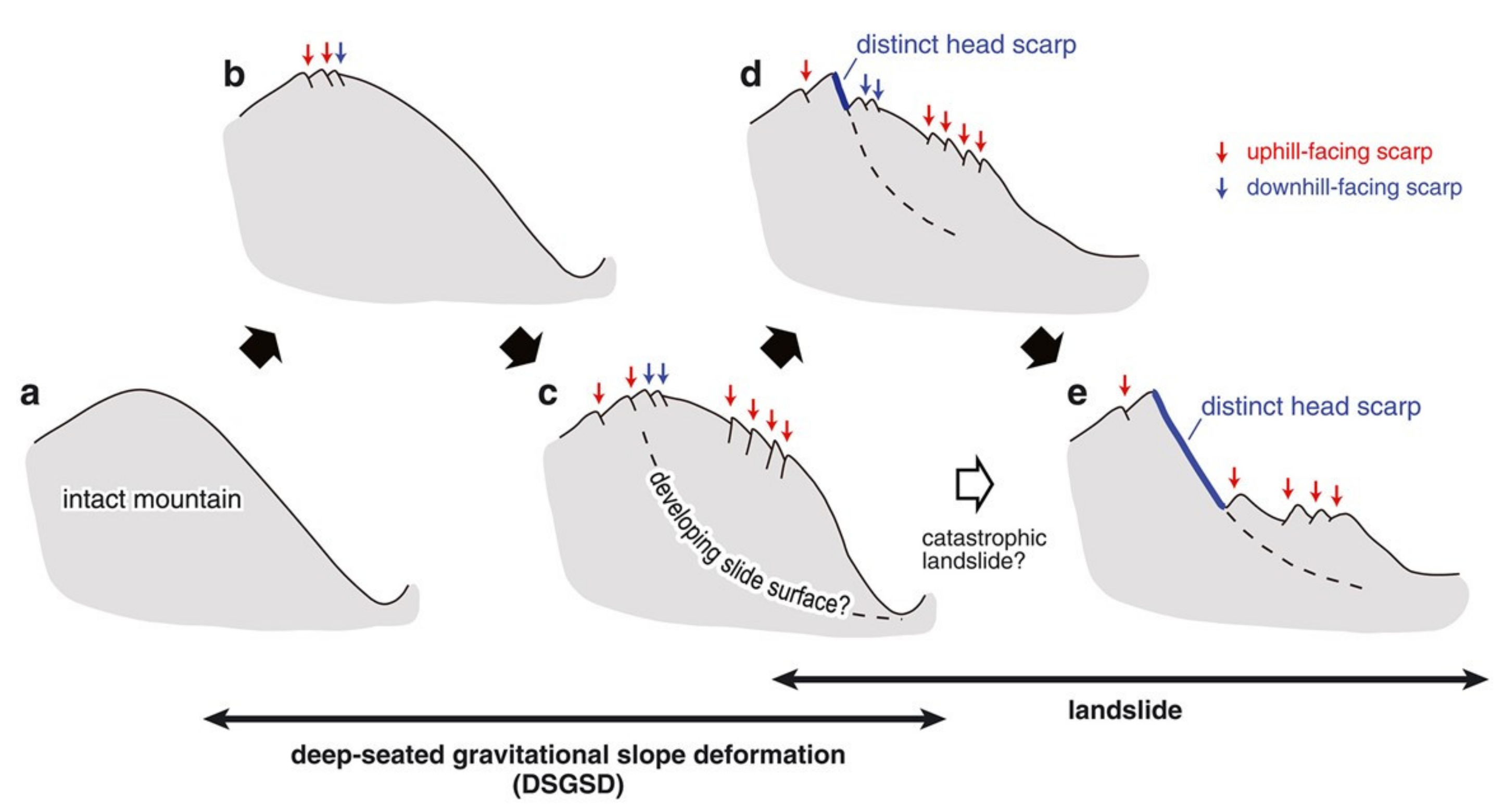
For large-scale landslides, the triggering mechanisms are complicated and highly time-dependent [21]. Where the slope is affected by gravity, it will gradually deform, and various types of microtopography may begin to appear on the slope surface (Figure 5b). When the deformation continues to be affected by gravity, the extent of deformation will increase, and failure surfaces in the slope will begin to develop (Figure 5c). When encountering a major event (typhoons, heavy rain, earthquakes, or human activities), because the slope has been deformed and strength is relatively weak, local damage (Figure 5d) or large-scale sliding (Figure 5e) may occur. However, under local damage conditions (Figure 5d), sliding surfaces may continue to develop under the influence of gravity and may also be converted into a one-time large-scale sliding incident during a major event (Figure 5e).
This process is generally represented by a strain-time curve shown as Figure 6 [22]. When a slope shows signs of deformation, the curve starts to change, which is called daily variation. When the daily variation accumulates and reaches start-up conditions, and slope deformation increases such that the daily variation changes from primary creep to secondary creep and then to tertiary creep. According to the rate of strain, the process includes decelerating deformation, constant velocity deformation, and accelerated deformation.
Faced with such a long-term process of change, which may often be in decades or centuries, the probability of occurrence is difficult to quantify directly. Under this circumstance, according to Intrieri et al. [23], it is necessary to figure out an “acceptable” method to predict landslide occurrence. Both rainfall and deformation could serve as a factor. Hence, in this study, rainfall was chosen to be the triggering factor concerning the development of mentioned large-scale landslides [24,25,26]. Additionally, subsequent deformation stages were used for results observation of on-site deformation monitoring equipment as indicators to judge whether a constant velocity deformation or accelerated deformation stage had been entered. As stated, the actual probability of large-scale landslides is difficult to estimate, but possible activation and onset conditions may be estimated through historical cases. Thus, this research mainly focused on the analysis of historical climate events induced by rainfall as a basis for determining the starting conditions that could be applied to emergency response systems for early warning and evacuation, the impact of earthquakes was not considered, and analysis of the extent of deformation often entails a significant quantity of on-site observational data, which is also beyond the scope of this research.
The occurrence of large-scale landslide is controlled by geology, materials, and landslide type classified in this study together indeed. While analyzing existing landslides happened in Oso and Kii Peninsula and those caused by Typhoon Morakot, geology, materials and landslide type were all taken into consideration [1,2,3]. However, every potential large-scale landslide area has its own features. Instead of focusing on the differences between each case, for governmental disaster management, it is more critical to develop an applicable disaster management framework which could be applied nationwide. Hence, the purpose of this study was to propose an early warning system for potential large-scale landslide.
3.2. Establishment of Rainfall Warning Threshold for Large-Scale Landslide
3.2.1. Landslide Cases Collation
To analyze the triggering rainfall of large-scale landslides, it is necessary to analyze data from prior existing cases. The Soil and Water Conservation Bureau uses signals obtained 259 large-scale landslides from a broadband seismic network. Among them, there are 80 cases of known occurrences during 22 rainfall events between 2001 and 2016 [27]. From comparative analysis of satellite images over the years, 179 rainfall induced large-scale landslide cases with unknown occurrence time were selected [28].
Then, based on the images before and after the landslide events, the cases were classified as new or enlarged occurrences (Figure 7). The results indicated that of the 80 cases with known occurrences, 28 were new cases, while the other 52 were enlarged cases. Among the 179 rainfall induced events, 79 were new cases, and the other 100 were enlarged incidents. (Figure 8) New cases were used to analyze the occurrence rainfall threshold for large-scale landslides.
3.2.2. Landslide Rainfall Analysis Methods
Slope stability analysis is a commonly used method in modern geotechnical engineering to explore the landslide mechanisms. The concept is based on whether shear stress or driving force acting on the slope exceeds the slope shear strength or resistance force as a criterion for judgment. The index often uses safety of factor, , as a quantification criterion. When the safety factor is less than 1.0, it signifies that the slope is in an unstable state. Therefore, through exploration of the landslide mechanisms, it is possible to explore the indicators of the occurrence of landslides from the various triggering factors.
The slope stability condition (that is, the safety factor) of any landslide can be expressed as (Equation (1)) with the infinite slope condition [29,30,31].
where is the total weight of the slicing unit (kN), is the slope angle, and is the friction coefficient of the slicing unit contacting the slope. In Equation (1), is the ratio of the pore water pressure to the total stress (), where is the pore water pressure, is the unit weight of water, and the height of the sliding mass. Among them, varies depending on the evolution of water content of the material during a rainfall event.
In summary, if the concept of safety factor is used to evaluate whether a large-scale landslide will occur, the relevant parameters are at least: effective water pressure head, landslide depth, slope angle, and landslide friction coefficient. For the effective water pressure head, due to the difficulty in grasping the groundwater conditions in practical work, the accumulated rainfall is first used as a replacement. In the landslide friction coefficient part, considering that the classification results collected by the historical incidents includes many types, the equivalent friction coefficient is also first used as a replacement. Thus, during analysis, evaluation of soil conditions employs dimensionless rainfall () for discussion, and the state after the landslide occurs is analyzed through dimensionless slope (). The usage parameters are as follows.
- Rainfall during landslide, R:There are several ways to calculate rainfall including rainfall peak, average rainfall intensity, and accumulated rainfall. Based on the research of Tsai et al. [29], Kuo et al. [27], and Yu [32], most of the large-scale landslides happened after rainfall peak and were significantly related to accumulated rainfall. Rainfall peak and average rainfall intensity have little connection to the occurrence of the large-scale landslides. Hence, accumulated rainfall was used for analysis in this study. Regarding the calculation method of rainfall events, this study deployed effective cumulative rainfall calculations, where effective cumulative rainfall included event rainfall (Ro) and prior rainfall (Ri). The event rainfall (Ro) was taken from 24-h rainfall before the landslide occurrence. If the rainfall lasted for more than 24 h, the rainfall exceeding 24 h was defined as the prior rainfall (Ri), and the calculation of the prior rainfall required consideration of a period of 7 days (144 h). For cases where the time of occurrence was already known, the effective accumulated rainfall was taken as the rainfall corresponding to that incident. In cases where only the occurrence of an event was known, the maximum effective accumulated rainfall of the event was taken as the representative rainfall.
- Depth of landslide, D:The depth of landslide was calculated with the volume (V) and area (A) of the landslide (Equation (2)). There are various papers discussing the formula for volume and depth estimation of landslides [33,34]. Considering the localized conditions in Taiwan, Water Resources Planning Institute [35], Tseng et al. [36] had proposed modified formulae which were collected and compared by the Soil and Water Conservation Bureau [37]. The formula used in this study was adopted from the research conducted by the Soils and Water Conservation Bureau (Equation (3)).
- The gradient of the slope where the landslide is located, θ:As the slope of a landslide may have multiple gradients, the averaged gradient within the landslide area was utilized. This research used the Zonal Statistics function of the spatial analysis module of ArcGIS software for calculations.
- Equivalent friction angle, Φ:Scheidegger [38] mentioned that the relationship between the equivalent friction coefficient (f) and the landslide volume (V) could be expressed as Formula (4). The relationship between equivalent friction coefficient (f) and equivalent friction angle (Φ) is shown as Formula (5). By using Formula (2), indicating the relationship between the projected landslide area (A) and the landslide volume (V), the equivalent friction angle (Φ) could be derived.
3.2.3. Establishment of Critical Rainfall for Large-Scale Landslide Occurrence
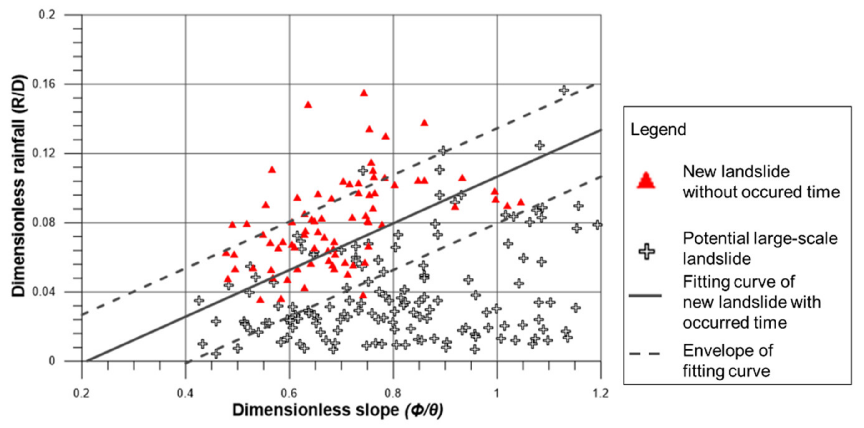
The dimensionless rainfall and dimensionless slope relationship (Figure 9) established by the large-scale landslide cases that have occurred can be used to evaluate possible rainfall in potential large-scale landslide areas. In Figure 9, the solid line is the regression line. Envelopes are represented by dotted lines, which were decided by the slope of the regression line and distribution of the data.
In Figure 10, new landslides with unknown time of occurrence (triangle) and potential large-scale landslides (cross) are shown. For new landslides with unknown time of occurrence, the accumulated rainfall for the whole rainfall events was calculated (R). For potential large-scale landslides, because there was no time failure, the largest accumulated rainfall for the past 20 years (R) was used in analysis for each case.
As shown in Figure 10, 74% of the new landslides with unknown time of occurrence are above the regression line, and 99% of them are located above the lower envelope. The result is reasonable because the accumulated rainfall used for analysis should be larger than occurrence rainfall of the large-scale landslides. For potential large-scale landslide areas, 90% of them were under the regression line, and only three cases were beyond the upper envelope. The regression line established by this study is feasible based on the abovementioned discussion and can be used to identify the relationship between rainfall and large-scale landslide occurrence. Taking data uncertainties into consideration, lower envelope, which covers most of the cases, is more suitable for setting the occurrence rainfall (Figure 11).
It can thus be seen that most of the incidents are above the regression line. Since the total rainfall is used for the analysis, its value must be higher than the actual occurrence rainfall. Hence, it is a reasonable phenomenon to find that the data are higher than the regression relationship.
In addition, the potential large-scale landslide area was analyzed with the dimensionless rainfall method. The data used for analysis were potential areas that had not undergone deep-seated sliding before. The maximum total rainfall record of each potential area over the past 20 years was used for analysis. The results are shown in Figure 11. In this analysis, it can be found that these potential large-scale landslide areas are mainly located below the fitting curve of landslide occurrence rainfall calculated using the existing landslides. This is reasonable because the historical rainfall events did not trigger large-scale landslides in these putative locations. Hence, it is recommended to take the envelope under the fitting curve as the critical line of large-scale landslide occurrence.
3.2.4. Establishing Rainfall Warning Threshold Value for Large-Scale Landslide Occurrence
The definition of critical rainfall refers to the accumulated rainfall required when a landslide occurs. If it is directly deployed as the warning criteria, it may pose significant risks for risk management. Thus, the concept of risk is generally considered, and differentiated management goals or safety factors are established for diverse risk values as a reference for establishing the warning threshold values. Establishing warning criteria is one of the means of risk management, but if the means of determination are overly conservative, it may be too easy to issue warnings and concomitantly increase social costs. In contrast, when a stricter mode of determination is adopted, large-scale landslides may have much greater impacts, which will demand too much preparation time resulting in loss of the possibility of practical ameliorative operations. Hence, while proposing the warning criteria, preparation time for evacuation should be considered.
The primary purpose for releasing a warning based on rainfall is to provide enough preparation time for disaster response. The preparation time required for evacuation in mountainous areas is 6 to 12 h, and for large-scale landslide areas, due to the largely affected areas, initial planning calls for analysis at 6 and 12 h pre-incident. Using the incidents of known occurrence time, the rainfall amounts were calculated 6 and 12 h before the incidents to obtain the occurrence rainfall amounts and then recalculated by using the critical line of large-scale landslide occurrence to obtain the 6 and 12 h rainfall warning criteria (Figure 12). According to the calculation results, the 12-h rainfall warning criteria are too low and may even be lower than the debris flow warning criteria, while the 6-h rainfall warning criteria are more reasonable based on the evacuation experience of local governments. The 6-h warning criteria should be adopted considering the preparation time needed for evacuation.
4. Results and Discussion
4.1. Results
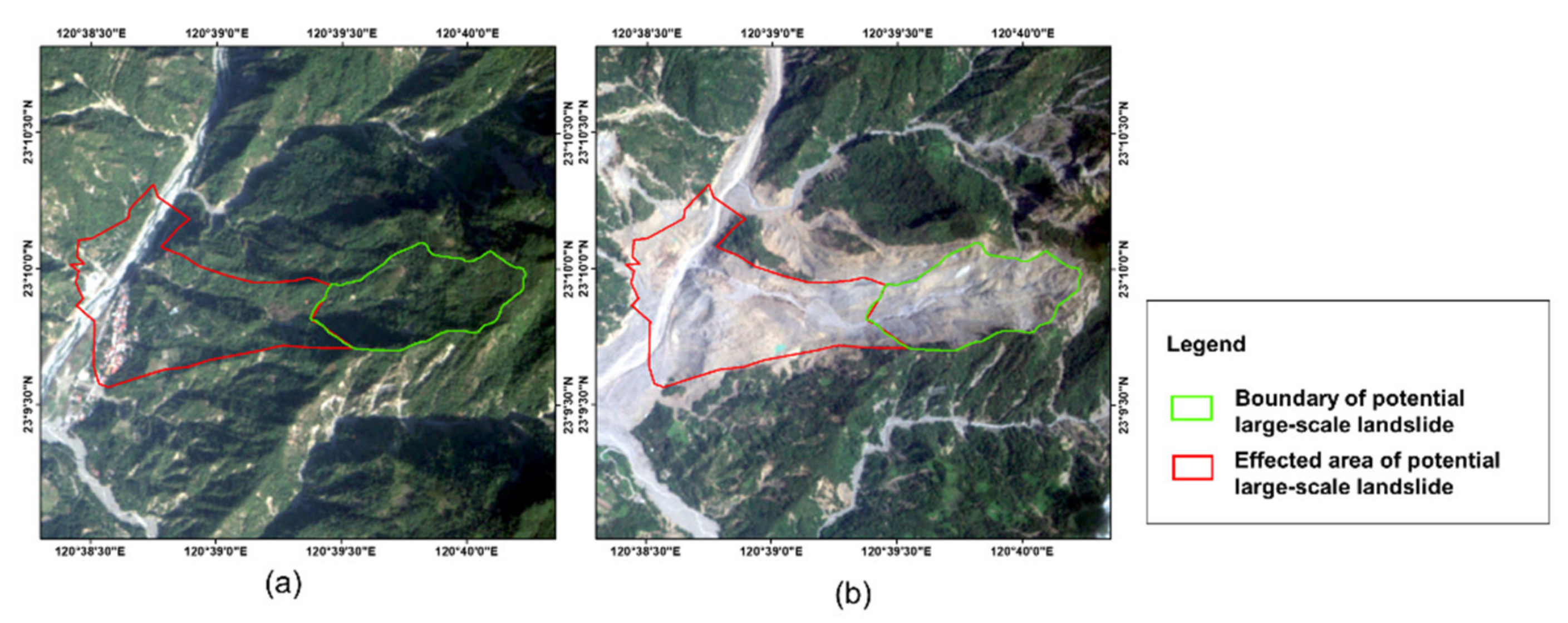
Large-scale landslides that occurred in Xiaolin Village (Figure 13a) were used to examine the effectiveness of the method. The event happened in 2009 with great impact including property losses and casualties (Figure 13b). For hazard zone delineation, the green line indicates the potential large-scale landslide areas that were produced afterwards. The red line represents the hazard zones, drawn based on the method proposed by this study. The villages devastated by the landslides were located within the hazard zones. For early warning, warning criteria for these two locations were calculated with the proposed method. According to the historical rainfall data (Figure 14) and the occurrences of large-scale landslides, the evacuation should be conducted before the disaster based on the warning value. Hence, methods for delineating the hazard zone and setting rainfall warning criteria could be practically effective for disaster avoidance.
4.2. Discussion
The debris flow emergency response system has been deployed in mountain areas for years and widely accepted by local residents thanks to the continuous educational programs. While developing the large-scale landslide emergency response system, integration into the current system is an important issue and could not only decrease the administrative cost but also increase the acceptance by residents. Therefore, feasibility and acceptability are discussed.
4.2.1. Feasibility Assessment for Emergency Response System
To avoid the troubles caused by an excessive warning system, the spatial distributions of the potential large-scale landslide area and debris flow were also used for classification. According to the spatial correlation between the two (Figure 15), they can be divided into:
- Type 1: Those that overlap with existing debris flow protected targets.The responsive preparedness method should continue the existing debris flow preparedness operations, giving due reference to the results of the large-scale landslide impact area designations and updating the existing evacuation procedures. When issuing alerts, they should be announced in conjunction with the existing debris flow contingency mechanisms and evacuations issued with reference to the current red-yellow warning system for debris flow.
- Type 2: Those that have no overlap with the existing debris flow protected targets.In response efforts, reference should be made to the results of the large-scale landslide impact area to increase the warning zone scope and develop new evacuation procedures. Warnings should be issued based on rainfall or other observational data, and on-site evacuation mechanisms should be established.
4.2.2. Acceptability Assessments for Emergency Response System
To assess the feasibility of response to large-scale landslides, the study deployed historical rainfall data from 2010 to 2019 for analysis and matched the existing debris flow warning values. The large-scale landslide warning criteria proposed in this plan were used to evaluate feasibility of the possible warning issuance scenarios (Figure 16).
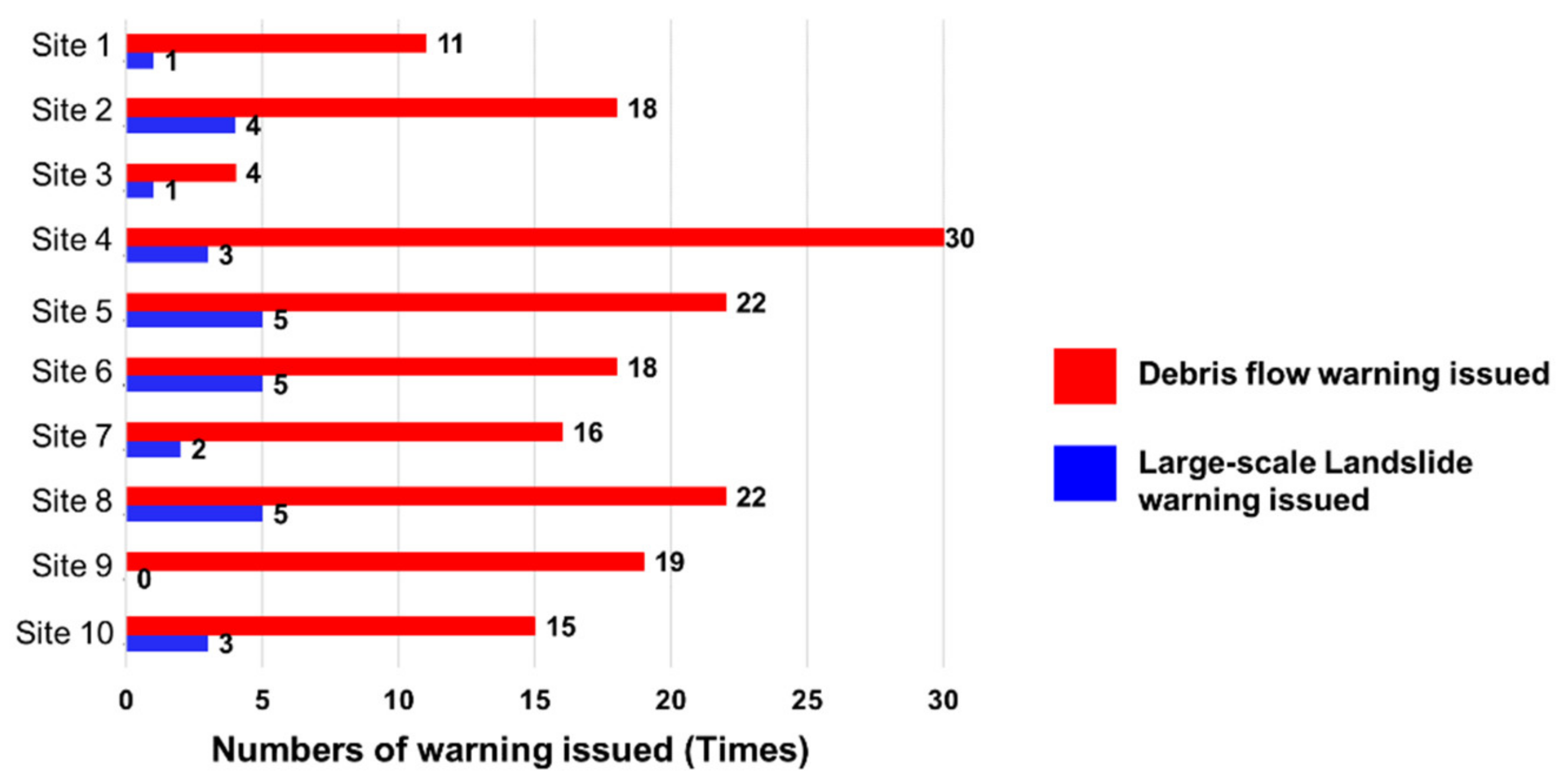
The historical rainfall was also used to research the frequency of issued warnings. The number of released warnings was once every 2 to 3 years using the large-scale landslide rainfall threshold value for warning and one to three times per year when adopting the debris flow rainfall threshold value for warning (Figure 17). Based on the feedback from the local governments and local representatives, the frequency seems acceptable but could be further revised based on the local conditions.
5. Conclusions
In facing large-scale landslides, the probability of occurrence is low, but whether a disaster will cause major losses depends on appropriate management. If a large number of disaster prevention and response measures are planned, although possible disasters can be minimized, as time progresses, a large quantity of resources will be continuously invested. There may thus be results with no obvious benefits, and popular acceptance will likely also decrease, which may form bottlenecks for implementation of disaster prevention work. On the other hand, if there is no active action taken due to low probabilities, once a disaster does in fact occur, subsequent losses and social costs may result in the government’s inability to effectively respond. Thus, given the situation where probability of occurrence cannot be adequately quantified, sound disaster risk management is essential.
This study’s proposed designated impact areas, determination of the rainfall warning threshold, and development of evacuation plans rely on risk avoidance methods in disaster risk management. It is essential to keep people away from possible disaster risks through the clear demarcation of danger zones and implementation of controls during typhoons and heavy rains, given the uncertainty of landslide incident occurrences. In addition to the aforesaid measures, due to the uncertainties of the risks involved, it is essential to include comprehensive education and promotion, localized risk communication, and feasible disaster insurance as systemic response efforts that should be strengthened for thepromotion of follow-up disaster prevention and mitigation plans.
Author Contributions
Data curation, Y.-J.T. and F.-T.S.; Funding acquisition, C.-R.C., H.-Y.Y. and S.-S.L.; Project administration, C.-L.S.; Writing—original draft, Y.-J.T. and F.-T.S. All authors have read and agreed to the published version of the manuscript.
Funding
This research was funded by the Soil and Water Conservation Bureau, Coucil of Agriculture, Executive Yuan, Taiwan, grant number SWCB-109-153.
Institutional Review Board Statement
Not applicable.
Informed Consent Statement
Not applicable.
Data Availability Statement
The data that support the findings of this study are available from the corresponding author, Y.-J.T., upon reasonable request.
Acknowledgments
We thank the Soil and Water Conservation Bureau of Council of Agriculture under Executive Yuan for providing information regarding the project, large-scale landslide disaster prevention, and mitigation under climate change.
Conflicts of Interest
The authors declare no conflict of interest.
References
- Chigira, M.; Matsushi, Y.; Tsou, C.Y.; Hiraishi, N.; Matsuzawa, M.; Matsuura, S. Deep-seated Catastrophic Landslides Induced by Typhoon 1112 (Talas). Annu. Disaster Prev. Res. Inst. Kyoto Univ. 2012, 5, 193–212. [Google Scholar]
- Haugerud, R.A. Preliminary Interpretation of Pre-2014 Landslide Deposits in the Vicinity of Oso, Washington; Open-File Report; US Geological Survey: Reston, VA, USA, 2014. [CrossRef] [Green Version]
- Shieh, C.-L.; Wang, C.-M.; Chen, Y.-S.; Tsai, Y.-J.; Tseng, W.-H. An Overview of Disasters Resulted from Typhoon Morakot in Taiwan. J. Disaster Res. 2010, 5, 236–244. [Google Scholar] [CrossRef]
- Chen, Y.S.; Kuo, Y.S.; Lai, W.C.; Tsai, Y.J.; Lee, S.P.; Chen, K.T.; Shieh, C.L. Reflection of typhoon Morakot - the challenge of compound disaster simulation. J. Mt. Sci. 2011, 8, 571–581. [Google Scholar] [CrossRef]
- Lee, C.T.; Dong, J.J.; Lin, M.L. Geological Investigation on the Catastrophic Landslide in Hsiaolin Village, Southern Taiwan. Sino-Geotech. 2010, 122, 87–94. [Google Scholar]
- Fan, J.C.; Liou, Y.C. Slope Disasters and Mechanism in Chishan River Basin. Sino-Geotech. 2010, 122, 21–30. [Google Scholar]
- Tang, C.L.; Hu, J.C.; Lo, C.M.; Lin, M.L. The Catastrophic 1999 Tsaoling and 2009 Hsiaoling Landslides: Preliminary Study from 3-D Distinct Element Modeling. Sino-Geotech. 2010, 122, 143–152. [Google Scholar]
- Chen, S.C.; Hsu, C.L. Landslide Dams Induced by Typhoon Morakot and Its Risk Assessment. Sino-Geotech. 2010, 122, 77–86. [Google Scholar]
- Kambara, J.; Uchida, T. Technical Guideline for Countermeasures against Deep-Seated Catastrophic (Rapid) Landslide; National Institute for Land and Infrastructure Management, Ministry of Land, Infrastructure, Transport and Tourism: Tsukuba, Japan, 2014. (In Japanese)
- U.S. House. H.R. 8810, National Landslide Preparedness Act; 116th Congress, 2nd Session; Government Printing Office: Washington, DC, USA, 2021.
- Soil and Water Conservation Bureau. Large-Scale Landslide Disaster Prevention and Mitigation under Climate Change; Soil and Water Conservation Bureau, Council of Agriculture, Executive Yuan: Nantou, Taiwan, 2016. (In Chinese)
- Lin, C.W.; Yi, D.C.; Huang, M.L. Digital terrain from airborne LiDAR—an effective tool for seeking potential large-scale landslides. Geo Topic 2012, 31, 44–48. [Google Scholar]
- Lin, M.-L.; Chen, T.-W.; Lin, C.-W.; Ho, D.-J.; Cheng, K.-P.; Yin, H.-Y.; Chen, M.-C. Detecting Large-Scale Landslides Using Lidar Data and Aerial Photos in the Namasha-Liuoguey Area, Taiwan. Remote Sens. 2013, 6, 42–63. [Google Scholar] [CrossRef] [Green Version]
- Lin, C.-W.; Tseng, C.-M.; Tseng, Y.-H.; Fei, L.-Y.; Hsieh, Y.-C.; Tarolli, P. Recognition of large scale deep-seated landslides in forest areas of Taiwan using high resolution topography. J. Asian Earth Sci. 2013, 62, 389–400. [Google Scholar] [CrossRef]
- Chen, R.-F.; Lee, C.-Y.; Yin, H.-Y.; Huang, H.-Y.; Cheng, K.-P.; Lin, C.-W. Monitoring the Deep-Seated Landslides by Using ALOS/PALSAR Satellite Imagery in the Disaster Area of 2009 Typhoon Morakot, Taiwan. In Advancing Culture of Living with Landslides; Springer International Publishing: Cham, Switzerland, 2017; pp. 239–247. [Google Scholar]
- Chen, K.-T.; Chen, T.-C.; Chen, X.-Q.; Chen, H.-Y.; Zhao, W.-Y. An experimental determination of the relationship between the minimum height of landslide dams and the run-out distance of landslides. Landslides 2021, 1–14. [Google Scholar] [CrossRef]
- Guzzetti, F.; Mondini, A.C.; Cardinali, M.; Fiorucci, F.; Santangelo, M.; Chang, K.-T. Landslide inventory maps: New tools for an old problem. Earth-Sci. Rev. 2012, 112, 42–66. [Google Scholar] [CrossRef] [Green Version]
- Tsai, Y.-J.; Lai, W.-C.; Hsu, T.-C.; Shieh, C.-L.; Huang, H.-Y.; Mikos, M.; Tiwari, B.; Yin, Y.; Sassa, K. Rainfall-Induced Large-Scale Landslide Hazard Zonation in Taiwan. In Advancing Culture of Living with Landslides; Springer International Publishing: Cham, Switzerland, 2017; pp. 719–732. [Google Scholar]
- Hiroshi, I.; Mizuyama, T. Flow and Deposit Properties of Debris Flow; Report of The Public Works Research Institute; Ministry of Construction: Ibaraki, Japan, 1982; 157, pp. 88–153.
- Kuo, Y.-S.; Tsang, Y.-C.; Chen, K.-T.; Shieh, C.-L. Analysis of landslide dam geometries. J. Mt. Sci. 2011, 8, 544–550. [Google Scholar] [CrossRef]
- Kaneda, H.; Kono, T. Discovery, Controls, and Hazards of Widespread Deep-Seated Gravitational Slope Deformation in the Etsumi Mountains, Central Japan. J. Geophys. Res. Earth Surf. 2017, 122, 2370–2391. [Google Scholar] [CrossRef] [Green Version]
- Saito, M. Forecasting the time of occurrence of a slope failure. In Proceedings of the 6th International Conference on Soil Mechanics and Foundation Engineering, Montreal, Canada, 8–15 September; 1965; pp. 537–541. [Google Scholar]
- Intrieri, E.; Carlà, T.; Gigli, G. Forecasting the time of failure of landslides at slope-scale: A literature view. Earth-Sci. Rev. 2019, 193, 333–349. [Google Scholar] [CrossRef]
- Guzzetti, F.; Peruccacci, S.; Rossi, M.; Stark, C.P. Rainfall thresholds for the initiation of landslides in central and southern Europe. Theor. Appl. Clim. 2007, 98, 239–267. [Google Scholar] [CrossRef]
- Martelloni, G.; Segoni, S.; Fanti, R.; Catani, F. Rainfall thresholds for the forecasting of landslide occurrence at regional scale. Landslides 2011, 9, 485–495. [Google Scholar] [CrossRef] [Green Version]
- Zezere, J.L.; Vaz, T.; Pereira, S.S.; Oliveira, S.C.; Marques, R.; Garcia, R.A.C. Rainfall thresholds for landslide activity in Portugal: A state of the art. Environ. Earth Sci. 2015, 73, 2917–2936. [Google Scholar] [CrossRef]
- Kuo, H.-L.; Lin, G.-W.; Chen, C.-W.; Saito, H.; Lin, C.-W.; Chen, H.; Chao, W.-A. Evaluating critical rainfall conditions for large-scale landslides by detecting event times from seismic records. Nat. Hazards Earth Syst. Sci. 2018, 18, 2877–2891. [Google Scholar] [CrossRef] [Green Version]
- Soil and Water Conservation Bureau. Investigation and Delimitation of Potential Large-Scale Landslide Hazard Zonation; Soil and Water Conservation Bureau: Nantou, Taiwan, 2016. (In Chinese)
- Tsai, T.T.; Tsai, Y.J.; Shieh, C.L. Critical Rainfall Analysis of Large-Scale Landslide Occurrence. In Proceedings of the Interpraenent 2018 in the Pacific Rim, Toyama, Japan, 1–4 October 2018. [Google Scholar]
- Barnes, G.E. Response to the book review published in Geotechnique 48, No. 447: G. E. Barnes, Soil mechanics: Principles and practice, Macmillan Press Ltd, 1995, ISBN 0-333-59654-4. Géotechnique 1998, 48, 869. [Google Scholar] [CrossRef]
- Duncan, J.M.; Wright, S.G. Soil Strength and Slope Stability; John Wiley: Hoboken, NJ, USA, 2005; p. 297. [Google Scholar]
- Yu, T.Y. Study on Occurrence Rainfall of Large-Scale Landslide. Master’s Thesis, National Cheng Kung University, Tainan, Taiwan, 2019. [Google Scholar]
- Guzzetti, F.; Ardizzone, F.; Cardinali, M.; Rossi, M.; Valigi, D. Landslide volumes and landslide mobilization rates in Umbria, central Italy. Earth Planet. Sci. Lett. 2009, 279, 222–229. [Google Scholar] [CrossRef]
- Jaboyedoff, M.; Carrea, D.; Derron, M.-H.; Oppikofer, T.; Penna, I.M.; Rudaz, B. A review of methods used to estimate initial landslide failure surface depths and volumes. Eng. Geol. 2020, 267, 105478. [Google Scholar] [CrossRef]
- Water Resources Planning Institute. Under Climate Change in the Sediment Treatment Measures in Southern River Basins—A Case Study Kaoping Watershed; Water Resources Planning Institute of Water Resources Agency; Ministry of Economic Affairs: Taipei, Taiwan, 2010. (In Chinese)
- Tseng, C.M.; Lin, C.W.; Stark, C.P.; Liu, J.K.; Fei, L.Y.; Hsieh, Y.C. Application of a Multi-temporal, LiDAR-derived, Digital Terrain Model in a Landslide-Volume Estimation. Earth Surface Processes Landforms 1587, 38. [Google Scholar] [CrossRef]
- Soil and Water Conservation Bureau. Development and Application of Disaster Prevention and Mitigation Technologies for Large-Scale Landslides; Soil and Water Conservation Bureau: Nantou, Taiwan, 2015. (In Chinese)
- Scheidegger, A.E. On the prediction of the reach and velocity of catastrophic landslides. Rock Mech. Rock Eng. 1973, 5, 231–236. [Google Scholar] [CrossRef]
Figure 1.
Landslide disasters occurred during Typhoon Morakot in Taiwan: (a) Landslide; (b) Debris flow; (c) Large-scale Landslide; (d) Landslide dam.
Figure 1.
Landslide disasters occurred during Typhoon Morakot in Taiwan: (a) Landslide; (b) Debris flow; (c) Large-scale Landslide; (d) Landslide dam.

Figure 2.
Strategy of large-scale landslide hazard mitigation in Taiwan. (modified from the Soil and Water Conservation Bureau, 2016).
Figure 2.
Strategy of large-scale landslide hazard mitigation in Taiwan. (modified from the Soil and Water Conservation Bureau, 2016).
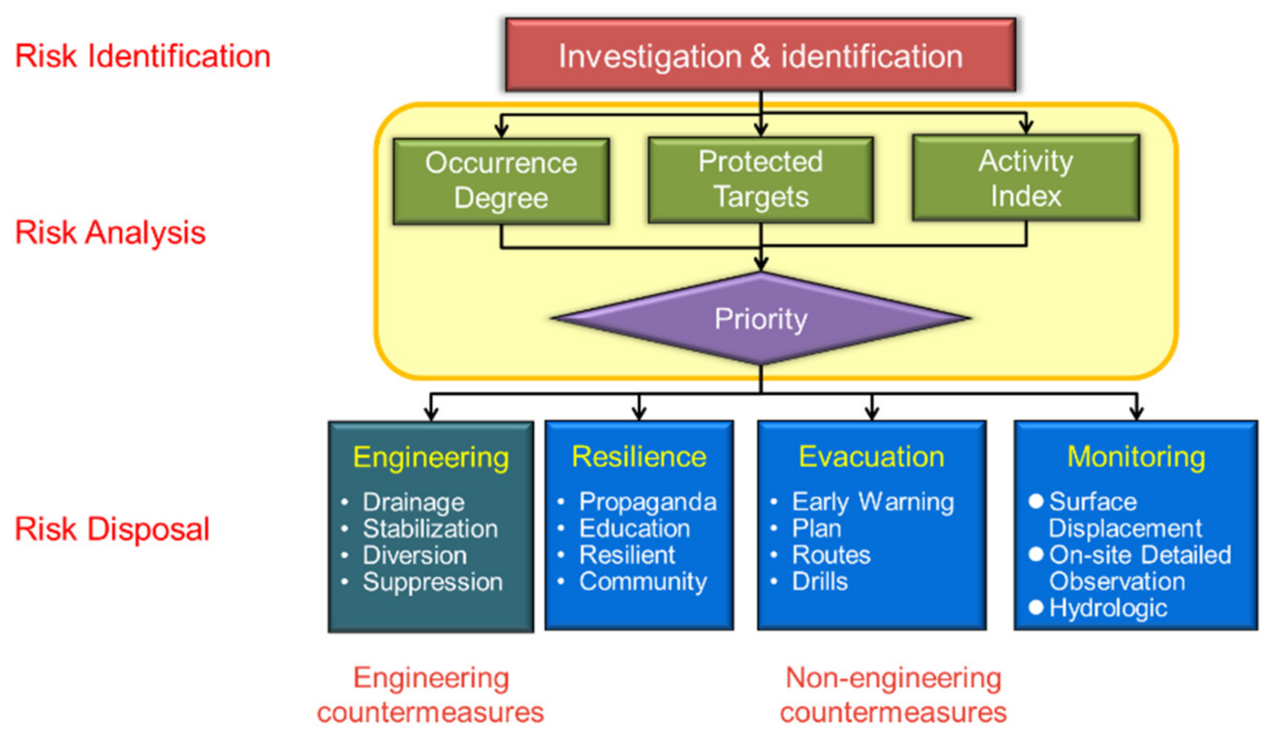
Figure 3.
Disaster caused by large-scale landslides (modified from Kambara et al., 2014). (a) Landslide type: The material runs into a plane or mild slope (without any topographical restriction); (b) Debris flow type: The material runs into a river. The river topography satisfies the occurrence condition of debris flow; (c) Natural dam type: The material runs into a river. The river slope is mild. The volume of the material could block the river flow.
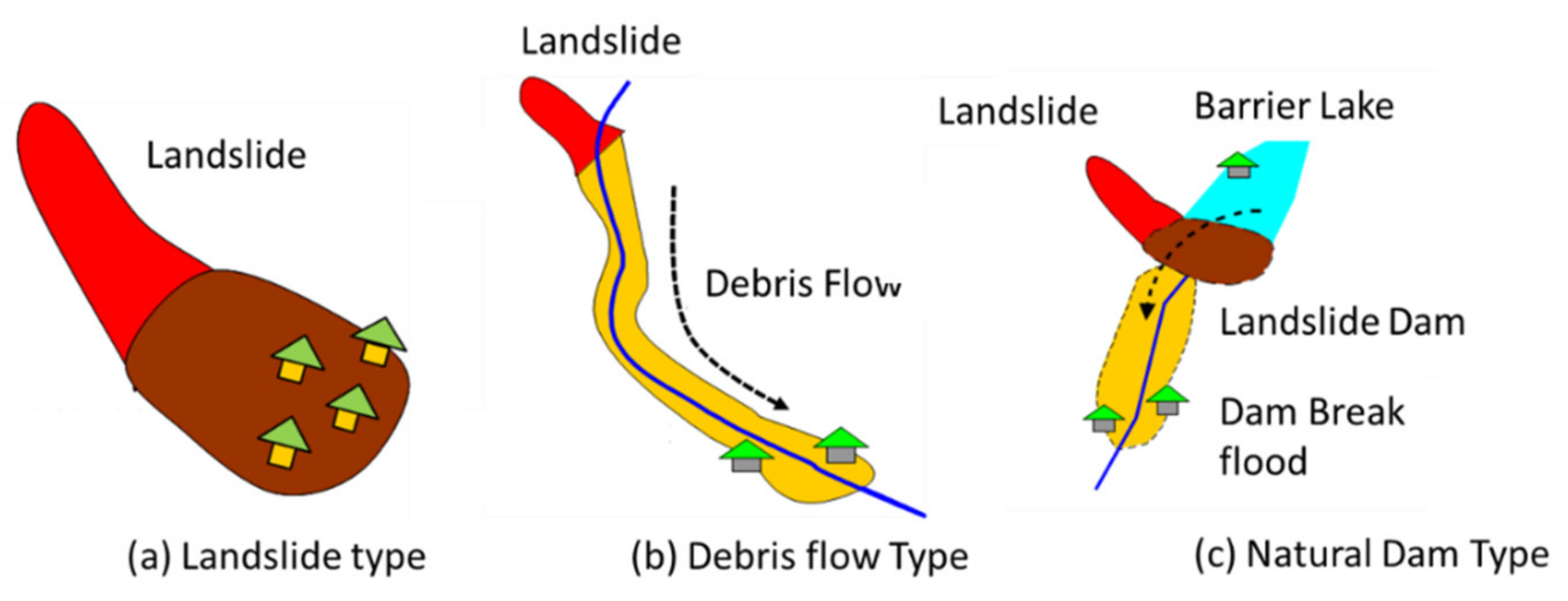
Figure 4.
Flowcharts of disaster classification for large-scale landslides (Tsai et al., 2017).
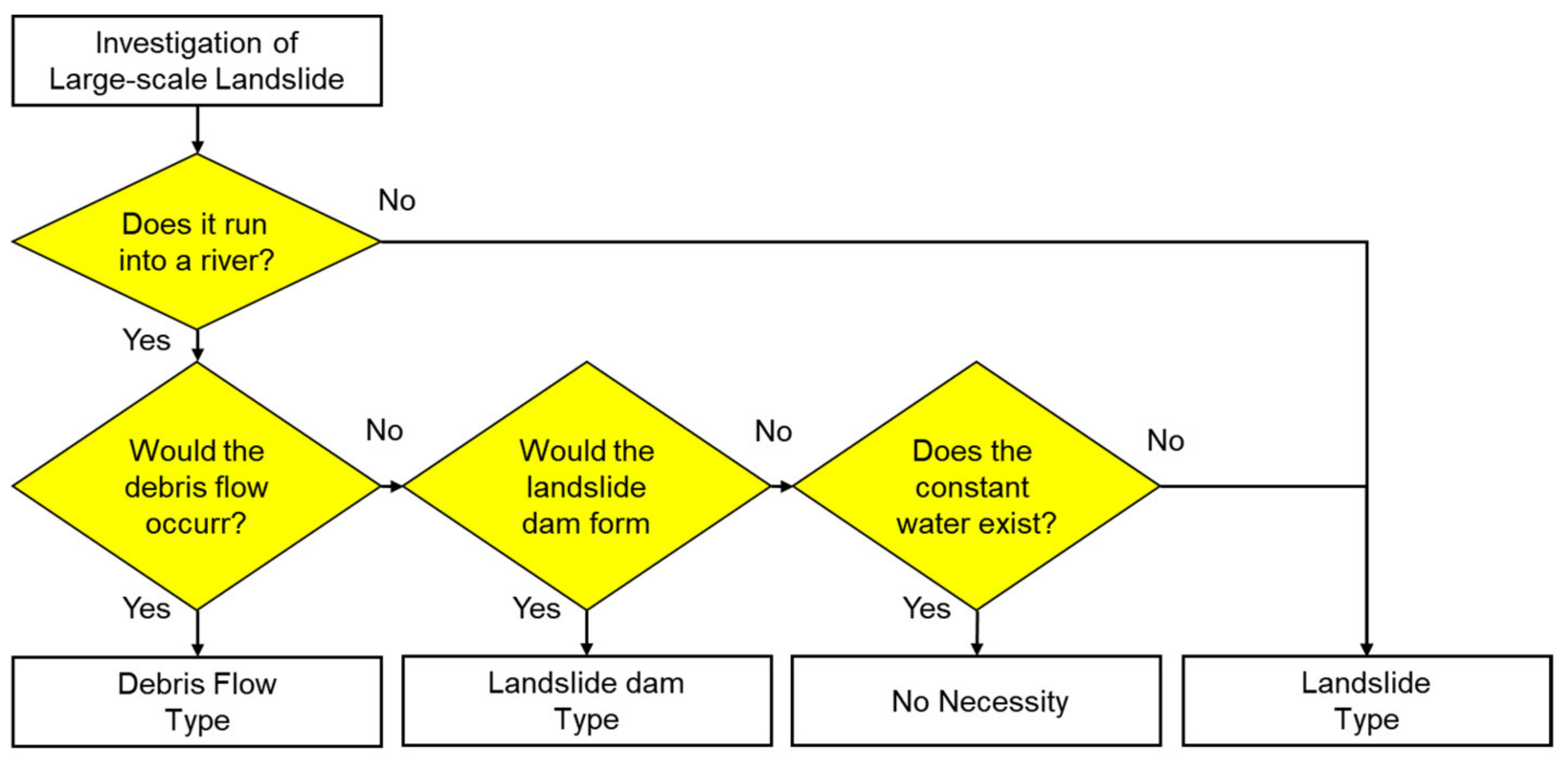
Figure 5.
Development of large-scale landslides (Kaneda and Kano, 2017).

Figure 6.
Strain-time curve in large-scale landslides (modified from Saito, 1965).

Figure 7.
Classification for new landslide and enlarged landslide. (a) Before the event, there is no obvious landslide to be found; (b) before the event, some landslides were found at the location of the landslide.
Figure 7.
Classification for new landslide and enlarged landslide. (a) Before the event, there is no obvious landslide to be found; (b) before the event, some landslides were found at the location of the landslide.
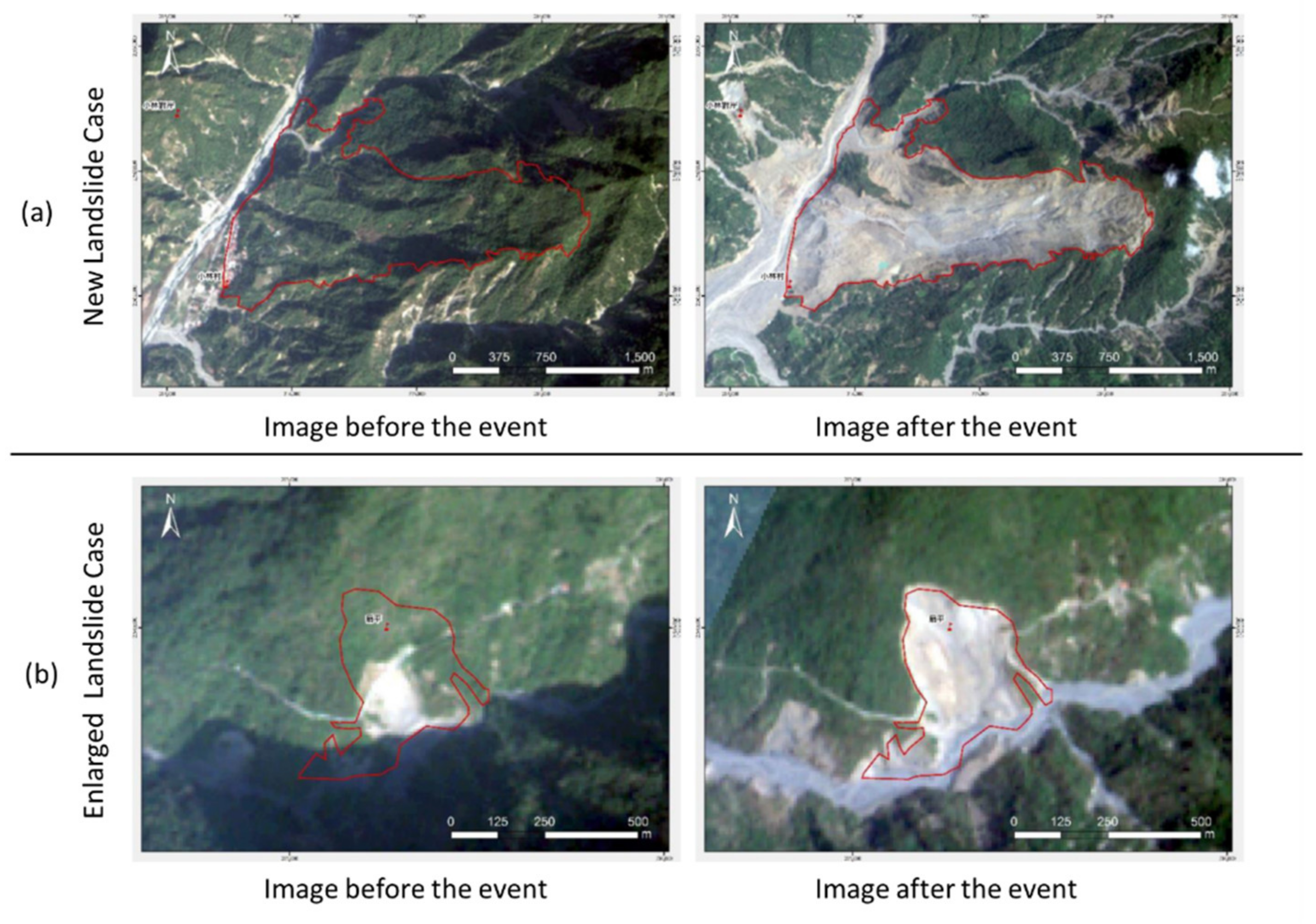
Figure 8.
Spatial distribution of new landslide cases for the occurrence rainfall threshold analysis.
Figure 8.
Spatial distribution of new landslide cases for the occurrence rainfall threshold analysis.
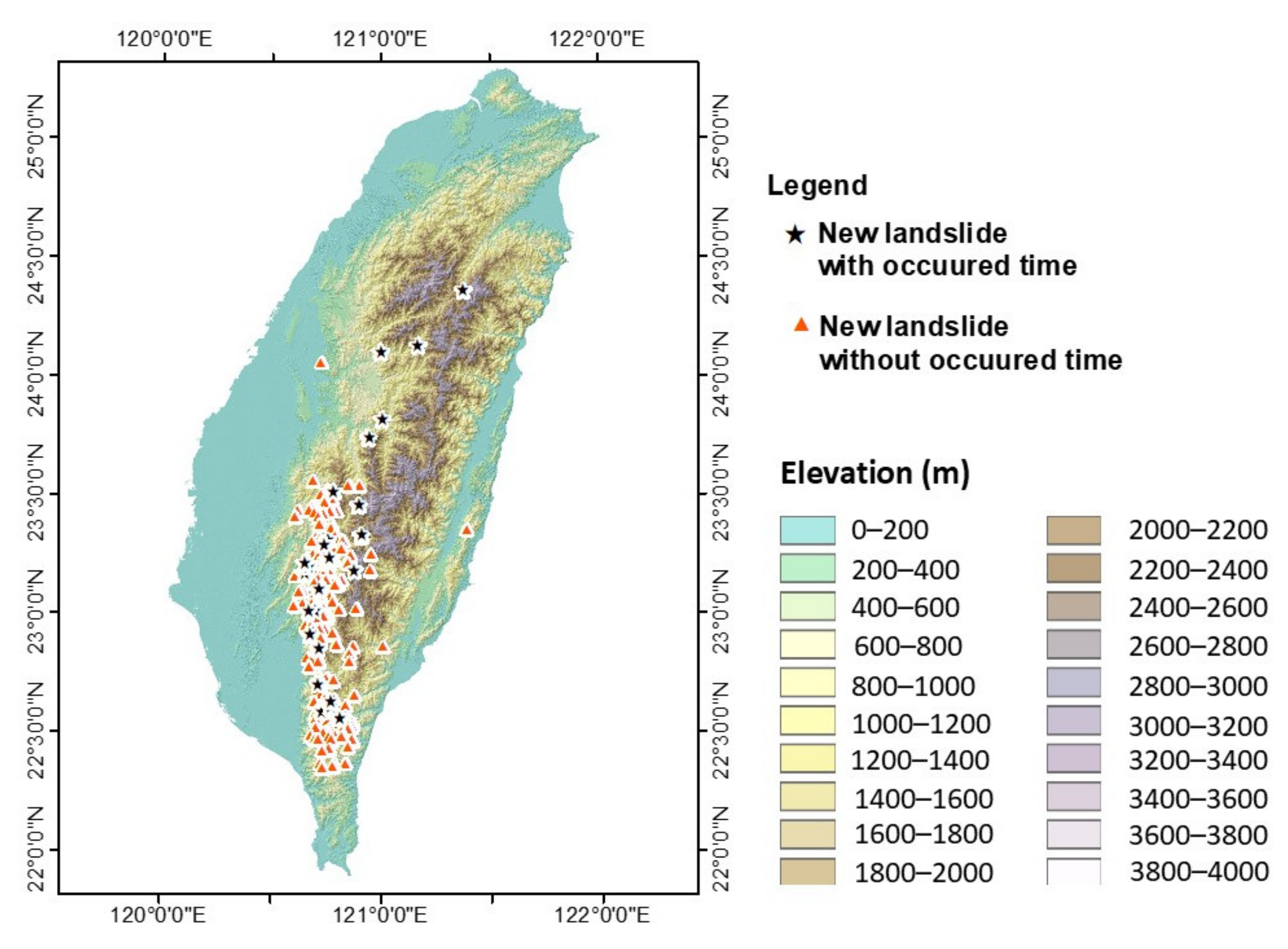
Figure 9.
Relationship between dimensionless rainfall and dimensionless slope for new landslides with time of occurrence.
Figure 9.
Relationship between dimensionless rainfall and dimensionless slope for new landslides with time of occurrence.
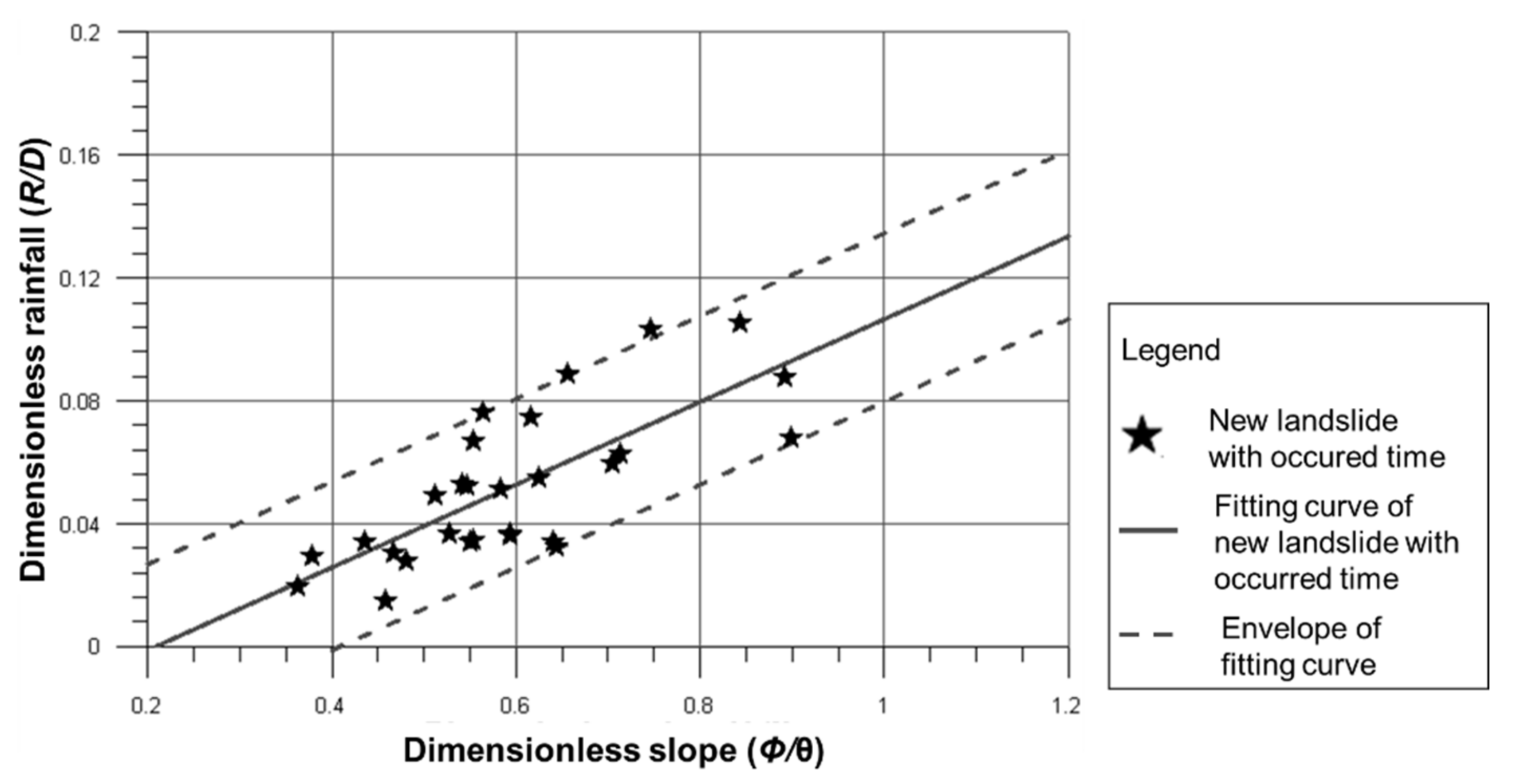
Figure 10.
Relationship between envelope of fitting curve and new landslides case and potential landslides.
Figure 10.
Relationship between envelope of fitting curve and new landslides case and potential landslides.

Figure 11.
Relationship between envelope of fitting curve and occurred large-scale landslides.
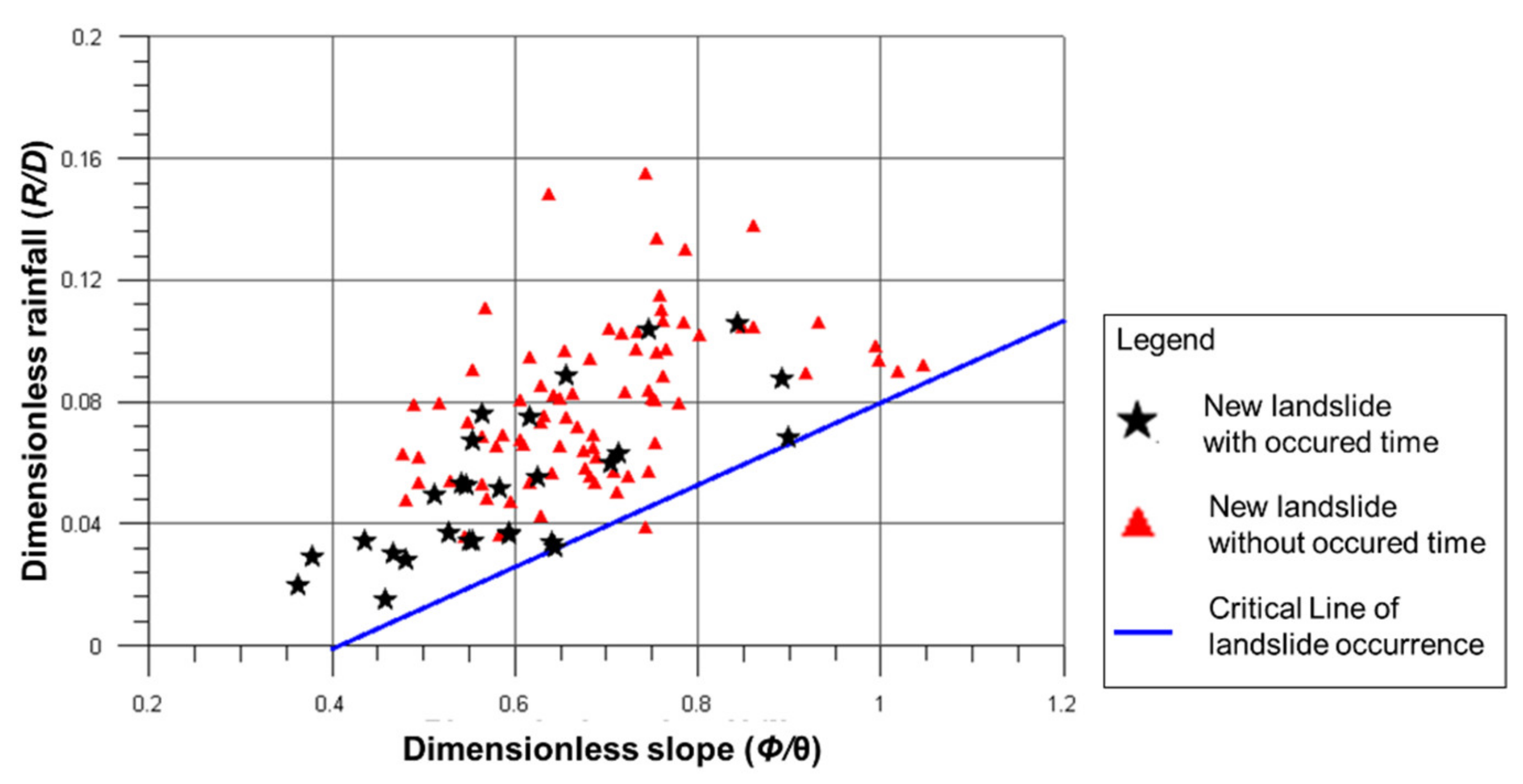
Figure 12.
Relationship between critical line and warning line for potential large-scale landslide.
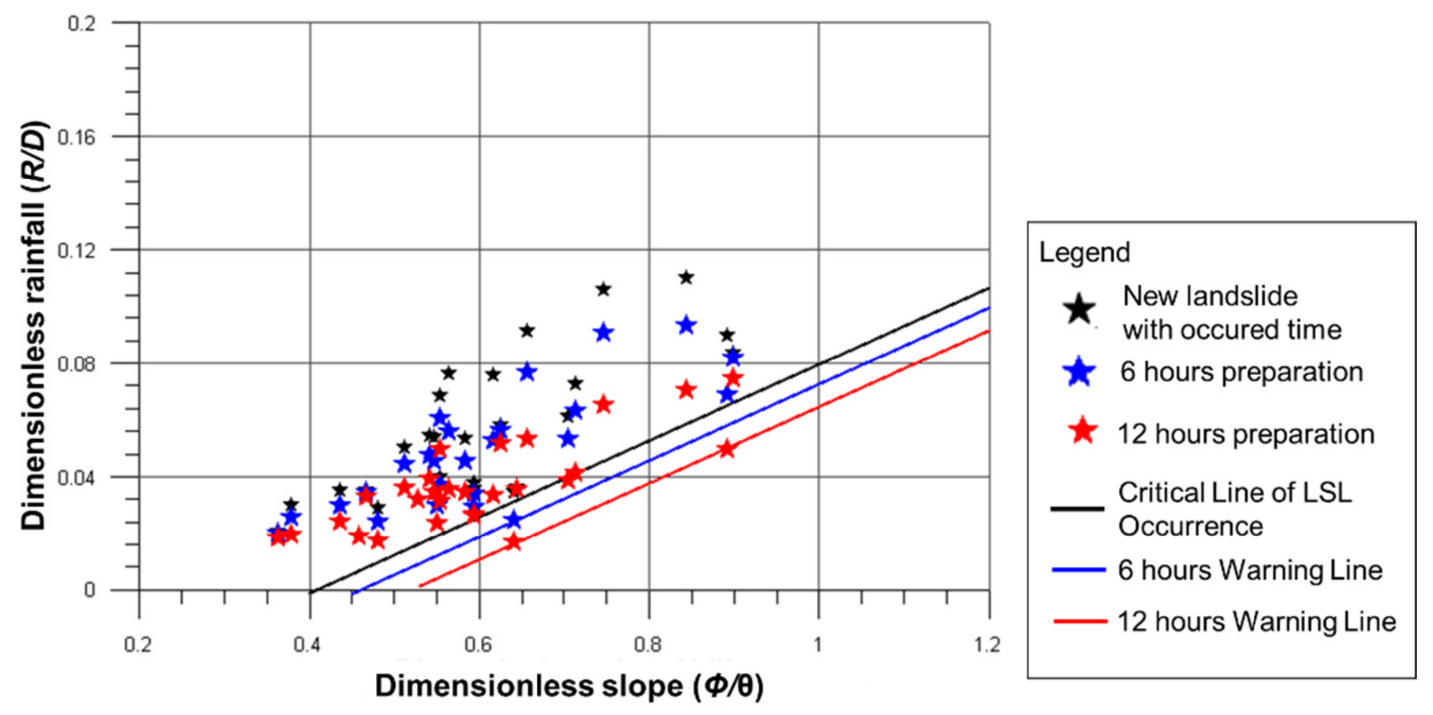
Figure 13.
Effectiveness review of large-scale landslide hazard mapping with historical event. (a) Image before the event; (b) image after the event.
Figure 13.
Effectiveness review of large-scale landslide hazard mapping with historical event. (a) Image before the event; (b) image after the event.

Figure 14.
Effectiveness review of large-scale landslide pre-warning with historical event.
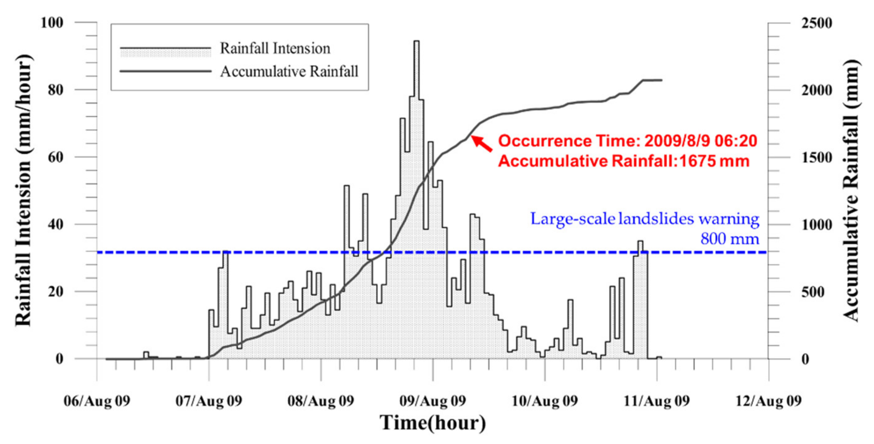
Figure 15.
Classification of warning systems for large-scale landslide. (a) Type 1: those that overlap with existing debris flow protected targets; (b) type 2: those that have no overlap with the existing debris flow protected targets.
Figure 15.
Classification of warning systems for large-scale landslide. (a) Type 1: those that overlap with existing debris flow protected targets; (b) type 2: those that have no overlap with the existing debris flow protected targets.
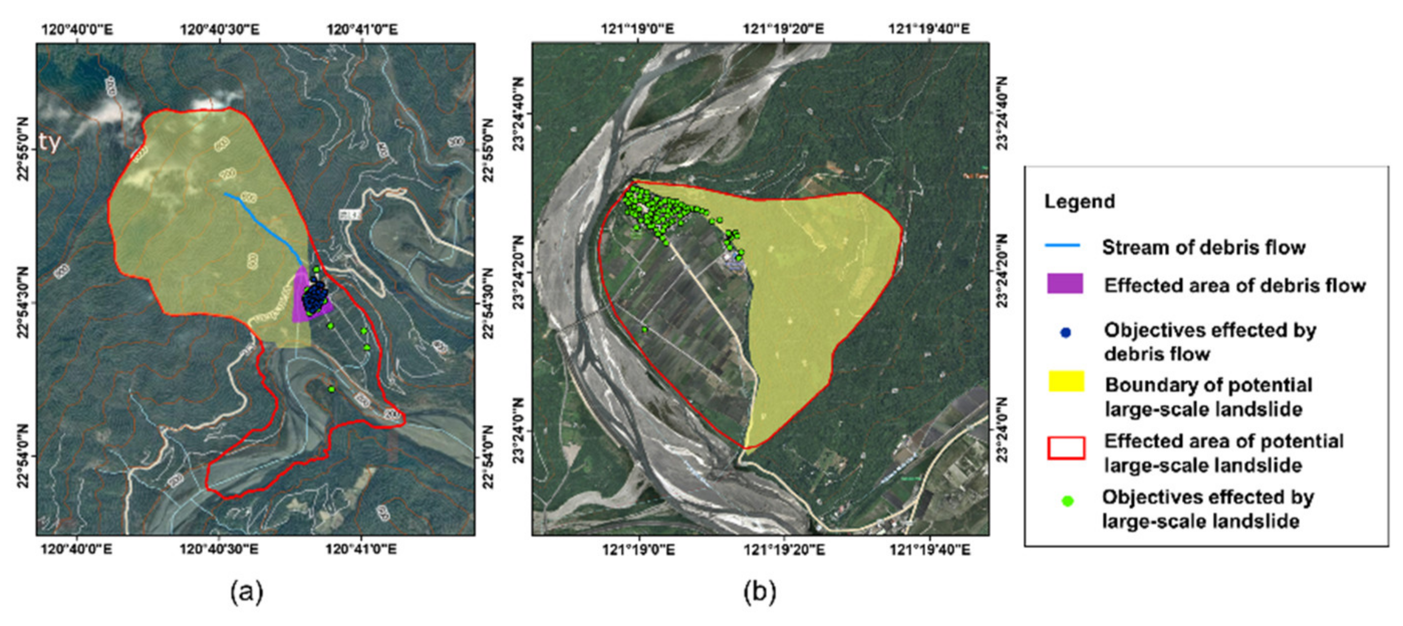
Figure 16.
Review of possible alert issuance scenarios for debris flow and large-scale landslide.
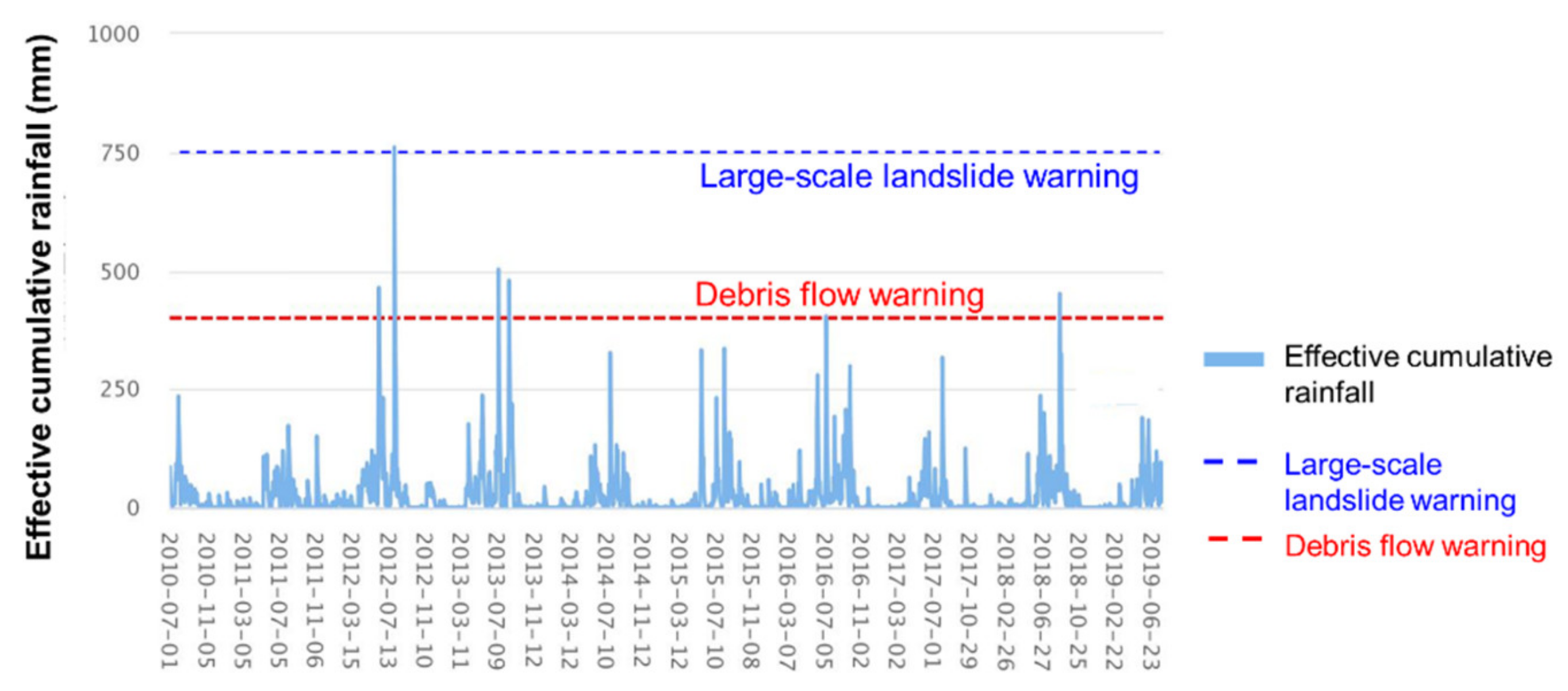
Figure 17.
Number of warnings issued for debris flow and large-scale landslides from 2011 to 2019.

Publisher’s Note: MDPI stays neutral with regard to jurisdictional claims in published maps and institutional affiliations. |
© 2021 by the authors. Licensee MDPI, Basel, Switzerland. This article is an open access article distributed under the terms and conditions of the Creative Commons Attribution (CC BY) license (http://creativecommons.org/licenses/by/4.0/).
Share and Cite
MDPI and ACS Style
Tsai, Y.-J.; Syu, F.-T.; Shieh, C.-L.; Chung, C.-R.; Lin, S.-S.; Yin, H.-Y. Framework of Emergency Response System for Potential Large-Scale Landslide in Taiwan. Water 2021, 13, 712. https://doi.org/10.3390/w13050712
AMA Style
Tsai Y-J, Syu F-T, Shieh C-L, Chung C-R, Lin S-S, Yin H-Y. Framework of Emergency Response System for Potential Large-Scale Landslide in Taiwan. Water. 2021; 13(5):712. https://doi.org/10.3390/w13050712
Chicago/Turabian StyleTsai, Yuan-Jung, Fang-Tsz Syu, Chjeng-Lun Shieh, Chi-Rong Chung, Shih-Shu Lin, and Hsiao-Yuan Yin. 2021. "Framework of Emergency Response System for Potential Large-Scale Landslide in Taiwan" Water 13, no. 5: 712. https://doi.org/10.3390/w13050712
Note that from the first issue of 2016, this journal uses article numbers instead of page numbers. See further details here.