Urban Sprawl and Adverse Impacts on Agricultural Land: A Case Study on Hyderabad, India

 ,
, 
Abstract
1. Introduction
2. Study Area
3. Data and Methods
3.1. Satellite Images
3.2. Image Normalization
3.2.1. IRS-P6 Data
3.2.2. Landsat-8 Data
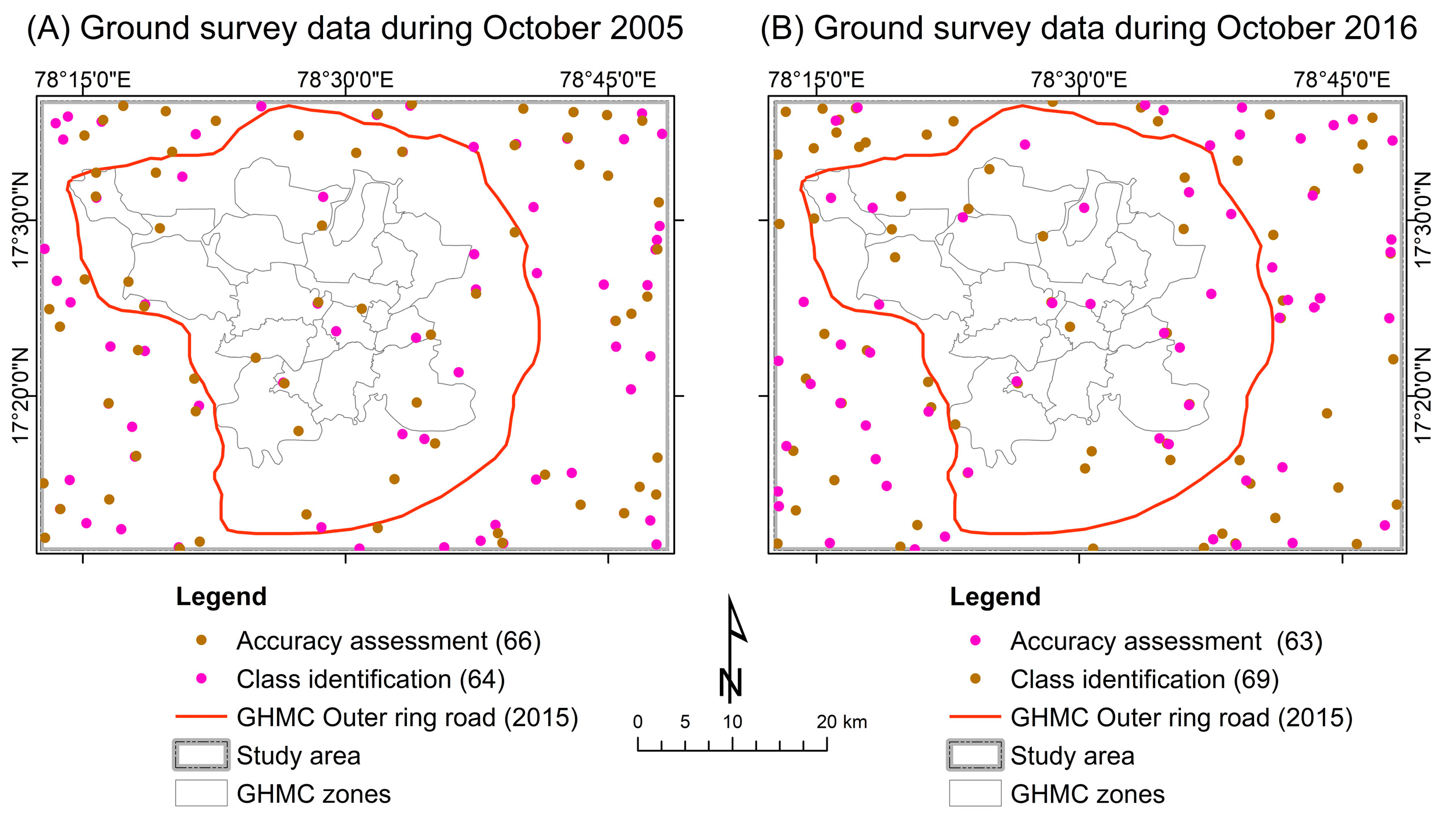
3.3. Ground Survey Datasets
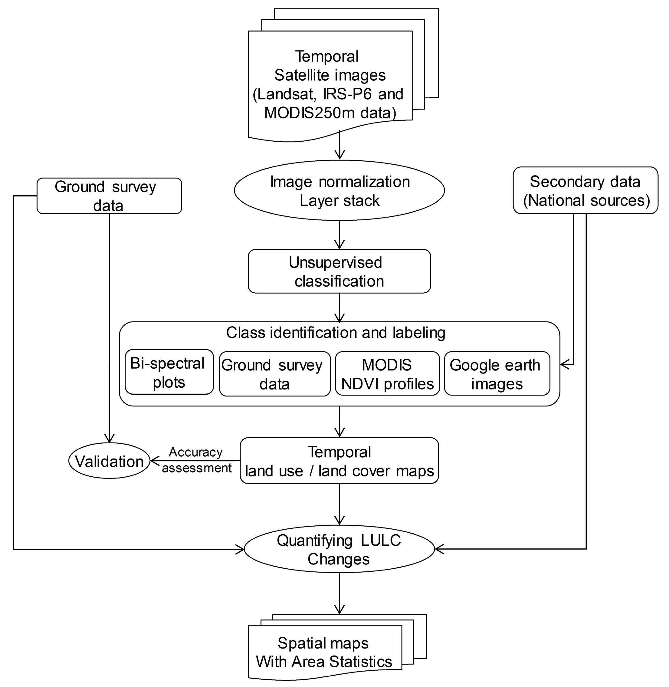
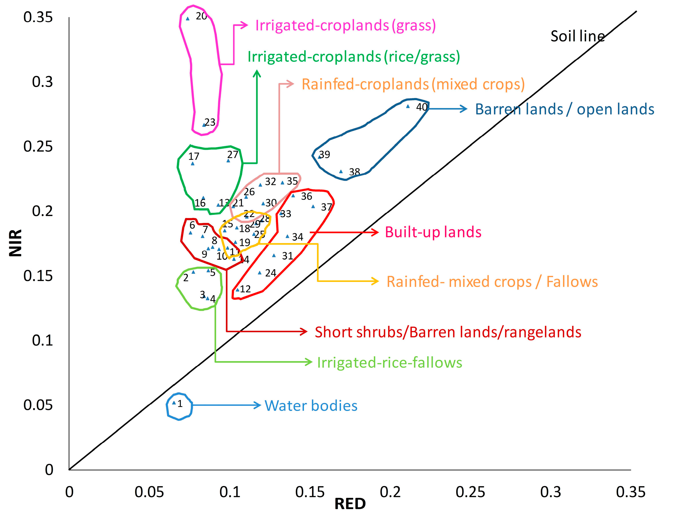
3.4. Mapping Land-Use/Land-Cover Changes
3.5. Urban Expansion and Other Land-Use Changes
4. Results and Discussion
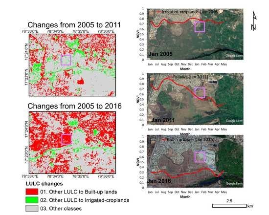
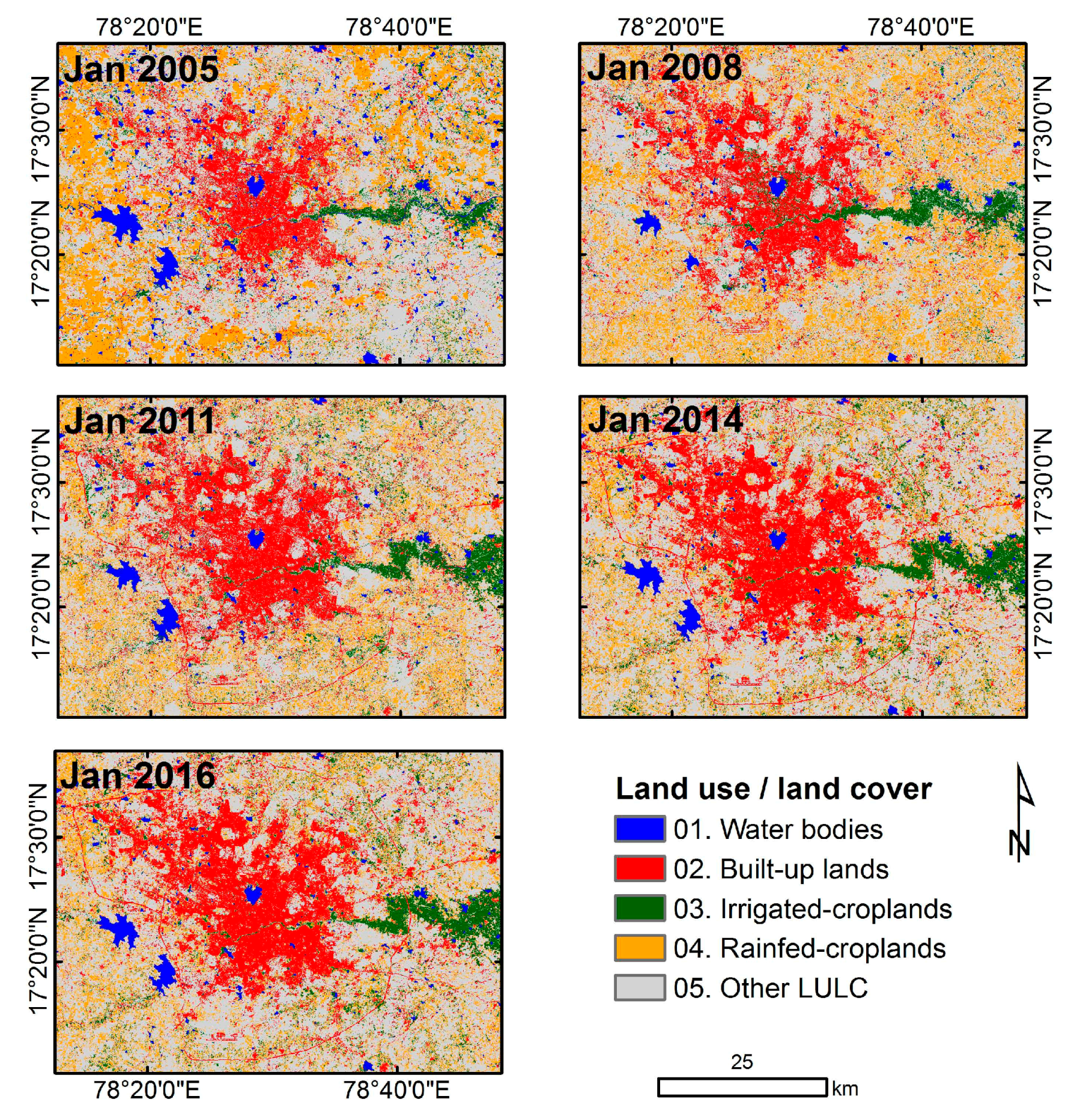
4.1. Spatio-Temporal Distribution of Land-Use/Land-Cover Changes
4.2. Validation
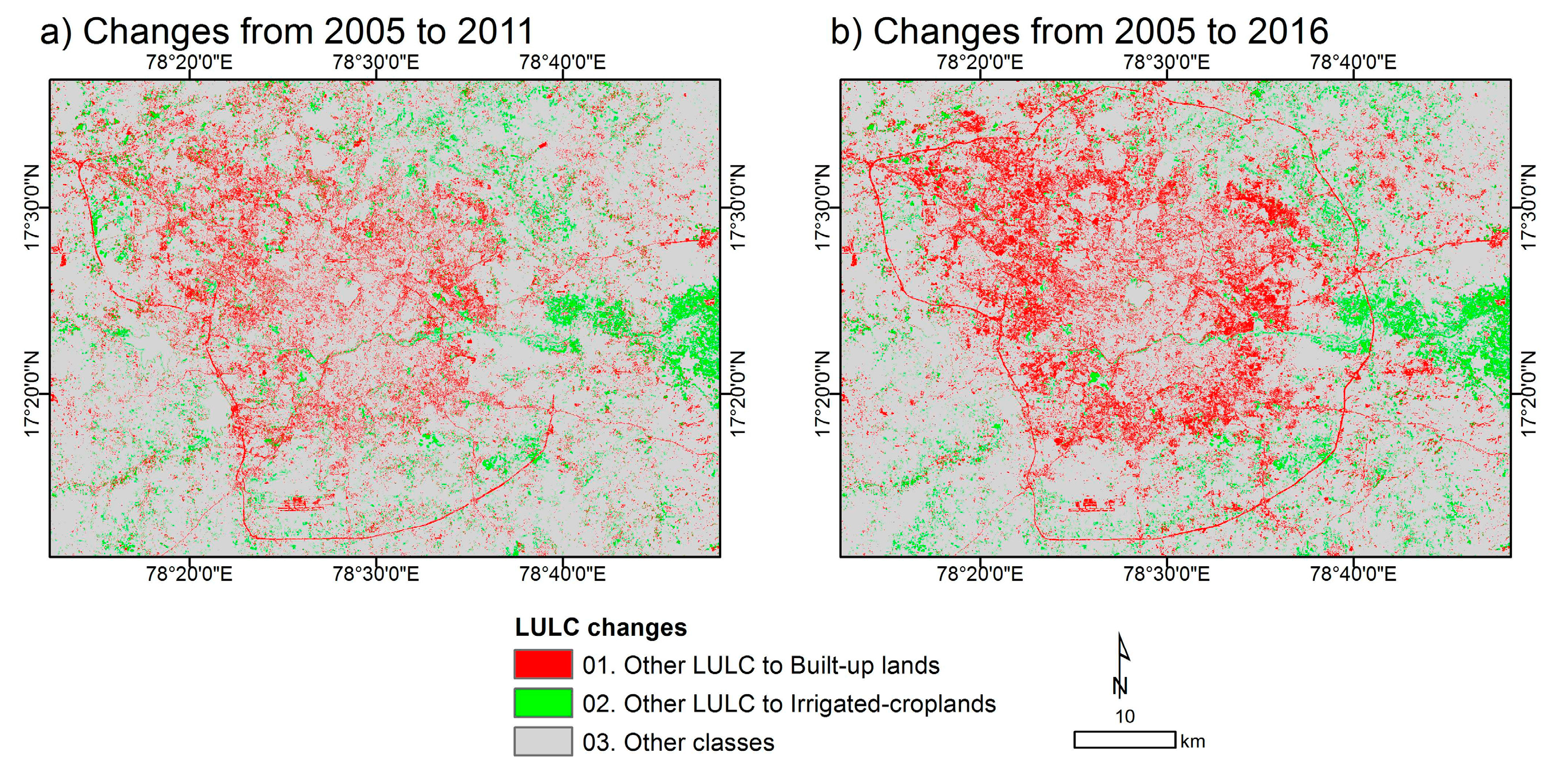
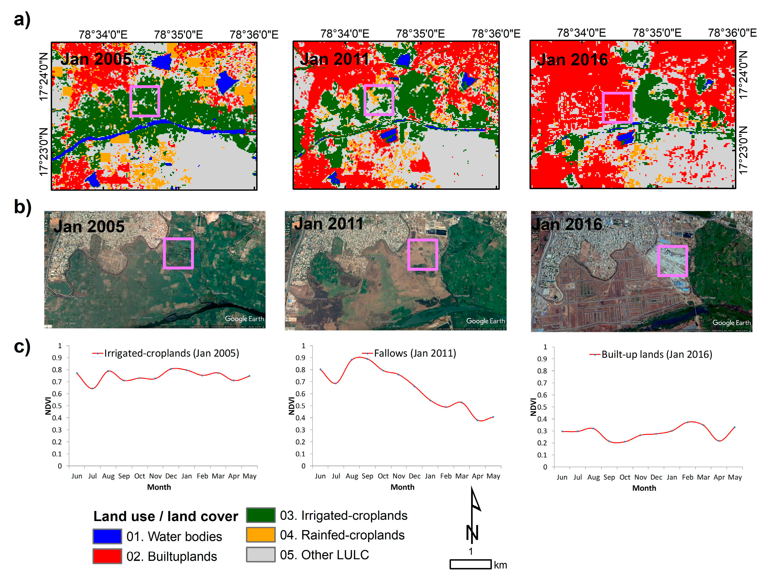
4.3. Urban Expansion and Other Changes
4.4. Discusssion on Land-Use/Land-Cover
5. Conclusions
Acknowledgments
Author Contributions
Conflicts of Interest
References
- International Food Policy Research Institute (IFPRI). 2017 Global Food Policy Report; IFPRI: Washington, DC, USA, 2017; Available online: http://www.Ifpri.Org/publication/2017-global-food-policy-report (accessed on 12 October 2017).
- United Nations (UN), Department of Economic and Social Affairs, Population Division (2014). World Urbanization Prospects: The 2014 Revision, Highlights (st/esa/ser.A/352). 2014. Available online: https://esa.Un.Org/unpd/wup/publications/files/wup2014-highlights.Pdf (accessed on 12 October 2017).
- Fan, C.; Myint, S.W.; Rey, S.J.; Li, W. Time series evaluation of landscape dynamics using annual Landsat imagery and spatial statistical modeling: Evidence from the phoenix metropolitan region. Int. J. Appl. Earth Obs. Geoinf. 2017, 58, 12–25. [Google Scholar] [CrossRef]
- Parece, T.E.; Campbell, J.B. Geospatial evaluation for urban agriculture land inventory: Roanoke, virginia USA. Int. J. Appl. Geospat. Res. 2017, 8, 43–63. [Google Scholar] [CrossRef]
- Mougeot, L.J. Urban agriculture: Definition, presence, potentials and risks. In Growing Cities, Growing Food: Urban Agriculture on the Policy Agenda; International Development Research Centre (IDRC): La Habana, Cuba, 2000; pp. 1–2. [Google Scholar]
- Deelstra, T.; Girardet, H. Urban agriculture and sustainable cities. In Growing Cities, Growing Food. Urban Agriculture on the Policy Agenda; Bakker, N., Dubbeling, M., Gündel, S., Sabel-Koshella, U., de Zeeuw, H., Eds.; Zentralstelle für Ernährung und Landwirtschaft (ZEL): Feldafing, Germany, 2000; pp. 43–66. [Google Scholar]
- Scheffers, B.R.; Paszkowski, C.A. The effects of urbanization on north american amphibian species: Identifying new directions for urban conservation. Urban Ecosyst. 2012, 15, 133–147. [Google Scholar] [CrossRef]
- Guderyahn, L.B.; Smithers, A.P.; Mims, M.C. Assessing habitat requirements of pond-breeding amphibians in a highly urbanized landscape: Implications for management. Urban Ecosyst. 2016, 19, 1801–1821. [Google Scholar] [CrossRef]
- Gumma, M.K.; Van Rooijen, D.; Nelson, A.; Thenkabail, P.S.; Aakuraju, R.V.; Amerasinghe, P. Expansion of urban area and wastewater irrigated rice area in Hyderabad, India. Irrig. Drain. Syst. 2011, 25, 135–149. [Google Scholar] [CrossRef]
- Van Rooijen, D.J.; Turral, H.; Wade Biggs, T. Sponge city: Water balance of mega-city water use and wastewater use in Hyderabad, India. Irrig. Drain. 2005, 54. [Google Scholar] [CrossRef]
- Alqurashi, A.; Kumar, L.; Sinha, P. Urban land cover change modelling using time-series satellite images: A case study of urban growth in five cities of Saudi Arabia. Remote Sens. 2016, 8, 838. [Google Scholar] [CrossRef]
- Cao, H.; Liu, J.; Fu, C.; Zhang, W.; Wang, G.; Yang, G.; Luo, L. Urban expansion and its impact on the land use pattern in xishuangbanna since the reform and opening up of China. Remote Sens. 2017, 9, 137. [Google Scholar] [CrossRef]
- Liu, F.; Zhang, Z.; Wang, X. Forms of urban expansion of chinese municipalities and provincial capitals, 1970s–2013. Remote Sens. 2016, 8, 930. [Google Scholar] [CrossRef]
- Ambast, S.K.; Keshari, A.K.; Gosain, A.K. Satellite remote sensing to support management of irrigation systems: Concepts and approaches. Irrig. Drain. 2002, 51, 25–39. [Google Scholar] [CrossRef]
- Bastiaanssen, W.G.M.; Molden, D.J.; Thiruvengadachari, S.; Smit, A.A.M.F.R.; Mutuwatte, L.; Jayasinghe, G. Remote Sensing and Hydrologic Models for Performance Assessment in Sirsa Irrigation Circle, India; International Water Management Institute: Colombo, Sri Lanka, 1999. [Google Scholar]
- Ozdogan, M.; Woodcock, C.E.; Salvucci, G.D. Monitoring changes in summer irrigated crop area in southeastern Turkey using remote sensing. In Proceedings of the 2003 IEEE International Geoscience and Remote Sensing Symposium (IGARSS), Toulouse, France, 21–25 July 2003; pp. 1570–1572. [Google Scholar]
- Sakthivadivel, R.; Thiruvengadachari, S.; Amerasinghe, U.; Bastiaanssen, W.G.M.; Molden, D. Performance Evaluation of the Bhakra Irrigation System, India, Using Remote Sensing and Gis Techniques; International Water Management Institute: Colombo, Sri Lanka, 1999. [Google Scholar]
- Thiruvengadachari, S.; Sakthivadivel, R. Satellite Remote Sensing for Assessment of Irrigation System Performance: A Case Study in India; Research Report 9; International Irrigation Management Institute: Colombo, Sri Lanka, 1997. [Google Scholar]
- Velpuri, N.M.; Thenkabail, P.S.; Gumma, M.K.; Biradar, C.B.; Noojipady, P.; Dheeravath, V.; Yuanjie, L. Influence of resolution in irrigated area mapping and area estimations. Photogramm. Eng. Remote Sens. 2009, 75, 1383–1395. [Google Scholar] [CrossRef]
- Parece, T.E.; Campbell, J.B. Comparing urban impervious surface identification using landsat and high resolution aerial photography. Remote Sens. 2013, 5, 4942–4960. [Google Scholar] [CrossRef]
- Myint, S.W.; Gober, P.; Brazel, A.; Grossman-Clarke, S.; Weng, Q. Per-pixel vs. Object-based classification of urban land cover extraction using high spatial resolution imagery. Remote Sens. Environ. 2011, 115, 1145–1161. [Google Scholar] [CrossRef]
- Zhang, D.; Huang, Q.; He, C.; Wu, J. Impacts of urban expansion on ecosystem services in the Beijing-Tianjin-Hebei urban agglomeration, China: A scenario analysis based on the shared socioeconomic pathways. Resour. Conserv. Recycl. 2017, 125, 115–130. [Google Scholar] [CrossRef]
- Biggs, T.W.; Thenkabail, P.S.; Gumma, M.K.; Scott, C.A.; Parthasaradhi, G.R.; Turral, H.N. Irrigated area mapping in heterogeneous landscapes with MODIS time series, ground truth and census data, krishna basin, India. Int. J. Remote Sens. 2006, 27, 4245–4266. [Google Scholar] [CrossRef]
- Draeger, W.C. Monitoring Irrigated Land Acreage Using Landsat Imagery: An Application Example; Technical Report; U.S. Geological Survey: Ritton, VA, USA, 1976; pp. 1–17.
- Gray, J.; Friedl, M.; Frolking, S.; Ramankutty, N.; Nelson, A.; Gumma, M. Mapping asian cropping intensity with MODIS. IEEE J. Sel. Top. Appl. Earth Obs. Remote Sens. 2014, PP, 1–7. [Google Scholar] [CrossRef]
- Gumma, M.K.; Deevi, K.; Mohammed, I.; Varshney, R.; Gaur, P.; Whitbread, A. Satellite imagery and household survey for tracking chickpea adoption in andhra pradesh, India. Int. J. Remote Sens. 2016, 37, 1955–1972. [Google Scholar] [CrossRef]
- Gumma, M.K.; Gauchan, D.; Nelson, A.; Pandey, S.; Rala, A. Temporal changes in rice-growing area and their impact on livelihood over a decade: A case study of Nepal. Agric. Ecosyst. Environ. 2011, 142, 382–392. [Google Scholar] [CrossRef]
- Gumma, M.K.; Kajisa, K.; Mohammed, I.A.; Whitbread, A.M.; Nelson, A.; Rala, A.; Palanisami, K. Temporal change in land use by irrigation source in Tamil Nadu and management implications. Environ. Monit. Assess. 2015, 187, 1–17. [Google Scholar] [CrossRef] [PubMed][Green Version]
- Gumma, M.K.; Mohanty, S.; Nelson, A.; Arnel, R.; Mohammed, I.A.; Das, S.R. Remote sensing based change analysis of rice environments in Odisha, India. J. Environ. Manag. 2015, 148, 31–41. [Google Scholar] [CrossRef] [PubMed]
- Gumma, M.K.; Thenkabail, P.S.; Maunahan, A.; Islam, S.; Nelson, A. Mapping seasonal rice cropland extent and area in the high cropping intensity environment of Bangladesh using MODIS 500 m data for the year 2010. ISPRS J. Photogramm. Remote Sens. 2014, 91, 98–113. [Google Scholar] [CrossRef]
- Gumma, M.K.; Thenkabail, P.S.; Muralikrishna, I.V.; Velpuri, M.N.; Gangadhararao, P.T.; Dheeravath, V.; Biradar, C.M.; Acharya Nalan, S.; Gaur, A. Changes in agricultural cropland areas between a water-surplus year and a water-deficit year impacting food security, determined using MODIS 250 m time-series data and spectral matching techniques, in the krishna river basin (India). Int. J. Remote Sens. 2011, 32, 3495–3520. [Google Scholar] [CrossRef]
- Gumma, M.K.; Thenkabail, P.S.; Hideto, F.; Nelson, A.; Dheeravath, V.; Busia, D.; Rala, A. Mapping irrigated areas of Ghana using fusion of 30 m and 250 m resolution remote-sensing data. Remote Sens. 2011, 3, 816–835. [Google Scholar] [CrossRef]
- World Population Review (WPR). Hyderabad Population 2017, World Population Review. 2017. Available online: http://worldpopulationreview.Com/world-cities/hyderabad-population/ (accessed on 21 July 2017).
- Van Rooijen, D.J.; Biggs, T.W.; Smout, I.; Drechsel, P. Urban growth, wastewater production and use in irrigated agriculture: A comparative study of accra, Addis Ababa and Hyderabad. Irrig. Drain. Syst. 2010, 24, 53–64. [Google Scholar] [CrossRef]
- United States Geological Survey (USGS) Earth Explores. Available online: https://earthexplorer.Usgs.Gov/ (accessed on 10 August 2017).
- Land Processes Distributed Active Archive Center (LPDAAC). LP DAAC:: NASA Land Data Products and Services—USGS. Available online: https://e4ftl01.Cr.Usgs.Gov/molt/mod13q1.006/ (accessed on 10 August 2017).
- Thenkabail, P.S.; Schull, M.; Turral, H. Ganges and indus river basin land use/land cover (LULC) and irrigated area mapping using continuous streams of MODIS data. Remote Sens. Environ. 2005, 95, 317–341. [Google Scholar] [CrossRef]
- Gumma, M.K.; Thenkabail, P.S.; Teluguntla, P.; Rao, M.N.; Mohammed, I.A.; Whitbread, A.M. Mapping rice-fallow cropland areas for short-season grain legumes intensification in South Asia using MODIS 250 m time-series data. Int. J. Digit. Earth 2016, 9, 981–1003. [Google Scholar] [CrossRef]
- Markham, B.L.; Barker, J.L. Landsat MSS and TM Post-Calibration Dynamic Ranges, Exoatmospheric Reflectances and At-Satellite Temperatures; Landsat Technical Notes; Earth Observation Satellite Company: Lanham, MD, USA, 1986; Volume 1. [Google Scholar]
- Gumma, M.K.; Pyla, K.; Thenkabail, P.; Reddi, V.; Naresh, G.; Mohammed, I.; Rafi, I. Crop dominance mapping with irs-p6 and MODIS 250-m time series data. Agriculture 2014, 4, 113–131. [Google Scholar] [CrossRef]
- Thenkabail, P.S.; Enclona, E.A.; Ashton, M.S.; Legg, C.; De Dieu, M.J. Hyperion, IKONOS, ALI, and ETM+ sensors in the study of african rainforests. Remote Sens. Environ. 2004, 90, 23–43. [Google Scholar] [CrossRef]
- Thenkabail, P. Biophysical and yield information for precision farming from near-real-time and historical Landsat tm images. Int. J. Remote Sens. 2003, 24, 2879–2904. [Google Scholar] [CrossRef]
- Neckel, H.; Labs, D. The solar radiation between 3300 and 12500 Å. Sol. Phys. 1984, 90, 205–258. [Google Scholar] [CrossRef]
- Gumma, M.K.; Nelson, A.; Thenkabail, P.S.; Singh, A.N. Mapping rice areas of South Asia using MODIS multitemporal data. J. Appl. Remote Sens. 2011, 5, 053547. [Google Scholar] [CrossRef]
- Gumma, M.K. Methods and Approaches for Irrigated Area Mapping at Various Spatial Resolutions Using Avhrr, MODIS and Landsat ETM+ Data for the Krishna River Basin, India. Ph.D. Thesis, Jawaharlal Nehru Technological University Hyderabad, Hyderabad, Telangana, India, 2008. Available online: http://publications.iwmi.org/pdf/H042567.pdf (accessed on 5 Sepetmber 2017).
- Krishna, G.M.; Prasad, T.S.; Bubacar, B. Delineating shallow ground water irrigated areas in the atankwidi watershed (northern Ghana, Burkina faso) using quickbird 0.61–2.44 meter data. Afr. J. Environ. Sci. Technol. 2010, 4, 455–464. [Google Scholar]
- Jensen, J.R. Iintroductory Digital Image Processing: A Remote Sensing Perspective, 3rd ed.; Prentice Hall: Upper Saddle River, NJ, USA, 2004; p. 544. [Google Scholar]
- Congalton, R.G. A review of assessing the accuracy of classifications of remotely sensed data. Remote Sens. Environ. 1991, 37, 35–46. [Google Scholar] [CrossRef]
- Congalton, R.G.; Green, K. Assessing the Accuracy of Remotely Sensed Data: Principles and Practices; Lewis: New York, NY, USA, 1999. [Google Scholar]
- Hyderabad Metropolitan Water Supply and Sewerage Board (HMWSSB). Available online: Http://www.Hyderabadwater.Gov.In/en/index.Php/projects_view?Projectid=946 (accessed on 10 August 2017).
- Hyderabad Metropolitan Development Authority (HMDA). Outer Ring Road. Available online: Https://www.Hmda.Gov.In/orr.Aspx (accessed on 10 August 2017).
- Depietri, Y.; Renaud, F.G.; Kallis, G. Heat waves and floods in urban areas: A policy-oriented review of ecosystem services. Sustain. Sci. 2012, 7, 95–107. [Google Scholar] [CrossRef]
- Thenkabail, P.; GangadharaRao, P.; Biggs, T.; Gumma, M.; Turral, H. Spectral matching techniques to determine historical land-use/land-cover (lulc) and irrigated areas using time-series 0.1-degree avhrr pathfinder datasets. Photogramm. Eng. Remote Sens. 2007, 73, 1029–1040. [Google Scholar]


| Sensor/Image Acquisition Date | Spatial (m) | No. of Bands | Band Range (µm) | Irradiance (W·m−2·sr−1·mm−1) | Potential Application |
|---|---|---|---|---|---|
| IRS-P6 January 2005 January 2008 January 2011 | 23.6 | 2 | 0.52–0.59 | 1857.7 | Water bodies and also capable of differentiating soil and rock surfaces from vegetation |
| 3 | 0.62–0.68 | 1556.4 | Sensitive to water turbidity differences | ||
| 4 | 0.77–0.86 | 1082.4 | Sensitive to strong chlorophyll absorption region and strong reflectance region for most soils. | ||
| 5 | 1.55–1.70 | 239.84 | Operates in the best spectral region to distinguish vegetation varieties and conditions | ||
| Landsat-8 January 2014, January 2016 | 30 | 1 | 0.43–0.45 | 555 | Water bodies and also capable of differentiating soil and rock surfaces from vegetation |
| 2 | 0.45–0.51 | 581 | |||
| 3 | 0.53–0.59 | 544 | Sensitive to water turbidity differences | ||
| 4 | 0.64–0.67 | 462 | Sensitive to strong chlorophyll absorption region and strong reflectance region for most soils. | ||
| 5 | 0.85–0.88 | 281 | Especially important for the ecology because healthy plants reflect it | ||
| 6 | 1.57–1.65 | 71.3 | Particularly useful for telling wet earth from dry earth, and for geology: rocks and soils that look similar in other bands often have strong contrasts in SWIR. | ||
| 7 | 2.11–2.09 | 24.3 | |||
| MODIS (2005–2016) | 250 | 1 | 0.62–0.67 | 1528.2 | Absolute Land Cover Transformation, Vegetation Chlorophyll |
| 2 | 0.84–0.88 | 974.3 | Cloud Amount, Vegetation Land Cover Transformation |
| LULC | Area (Ha) | ||||
|---|---|---|---|---|---|
| 2005 | 2008 | 2011 | 2014 | 2016 | |
| 01. Water bodies | 12,535 | 3584 | 5417 | 5694 | 2283 |
| 02. Built-up land | 38,863 | 62,000 | 68,560 | 74,131 | 80,111 |
| 03. Irrigated cropland | 15,553 | 14,589 | 19,966 | 19,510 | 19,678 |
| 04. Rainfed cropland | 72,817 | 69,601 | 53,361 | 46,815 | 37,902 |
| 05. Other LULC | 161,635 | 151,562 | 154,288 | 155,445 | 161,583 |
| Classified Data | Reference Data (Ground Survey Data) | |||||||||
|---|---|---|---|---|---|---|---|---|---|---|
| 01. Water Bodies | 02. Built-Up Land | 03. Irrigated Cropland | 04. Rainfed Cropland | 05. Other LULC | Row Total | Number Correct | Producer Accuracy | User Accuracy | Kappa | |
| 01. Water bodies | 11 | 0 | 0 | 0 | 0 | 11 | 11 | 100% | 100% | 100% |
| 02. Built-up land | 0 | 6 | 0 | 0 | 0 | 6 | 6 | 75% | 100% | 100% |
| 03. Irrigated cropland | 0 | 0 | 3 | 0 | 1 | 4 | 3 | 50% | 75% | 72% |
| 04. Rainfed cropland | 0 | 0 | 1 | 10 | 1 | 12 | 10 | 67% | 83% | 78% |
| 05. Other LULC | 0 | 2 | 2 | 5 | 22 | 31 | 22 | 92% | 71% | 54% |
| Column Total | 11 | 8 | 6 | 15 | 24 | 64 | 52 | |||
| Overall classification accuracy = 81.25% | Overall kappa statistic = 0.7422 | |||||||||
| Classified Data | Reference Data (Ground Survey Data) | |||||||||
|---|---|---|---|---|---|---|---|---|---|---|
| 01. Water Bodies | 02. Built-up Land | 03. Irrigated Cropland | 04. Rainfed Cropland | 05. Other LULC | Row Total | Number Correct | Producer Accuracy | User Accuracy | Kappa | |
| 01. Water bodies | 9 | 0 | 1 | 0 | 0 | 10 | 9 | 100% | 90% | 88% |
| 02. Built-up land | 0 | 12 | 0 | 0 | 0 | 12 | 12 | 100% | 100% | 100% |
| 03. Irrigated cropland | 0 | 0 | 5 | 1 | 1 | 7 | 5 | 71% | 71% | 68% |
| 04. Rainfed cropland | 0 | 0 | 0 | 4 | 2 | 6 | 4 | 44% | 67% | 61% |
| 05. Other LULC | 0 | 0 | 1 | 4 | 20 | 25 | 20 | 87% | 80% | 68% |
| Column Total | 9 | 12 | 7 | 9 | 23 | 60 | 50 | |||
| Overall classification accuracy = 83.33% | Overall kappa statistic = 0.7768 | |||||||||
| Classified Data | Reference Data (Ground Survey Data) | |||||||||
|---|---|---|---|---|---|---|---|---|---|---|
| 01. Water Bodies | 02. Built-Up Land | 03. Irrigated Cropland | 04. Rainfed Cropland | 05. Other LULC | Row Total | Number Correct | Producer Accuracy | User Accuracy | Kappa | |
| 01. Water bodies | 8 | 0 | 0 | 0 | 0 | 8 | 8 | 80% | 100% | 100% |
| 02. Built-up land | 0 | 12 | 0 | 0 | 1 | 13 | 12 | 100% | 92% | 91% |
| 03. Irrigated cropland | 1 | 0 | 7 | 0 | 0 | 8 | 7 | 70% | 88% | 85% |
| 04. Rainfed cropland | 0 | 0 | 0 | 1 | 0 | 1 | 1 | 20% | 100% | 100% |
| 05. Other LULC | 1 | 0 | 3 | 4 | 31 | 39 | 31 | 97% | 79% | 62% |
| Column Total | 10 | 12 | 10 | 5 | 32 | 69 | 59 | |||
| Overall classification accuracy = 85.51% | Overall kappa statistic = 0.7838 | |||||||||
| Land-Use/Land-Cover (2011) | Land-Use/Land-Cover, Ha (2005) | ||||
|---|---|---|---|---|---|
| 01. Water Bodies | 02. Built-Up Land | 03. Irrigated Cropland | 04. Rain-Fed Cropland | 05. Other LULC | |
| 01. Water bodies | 5011 | 0 | 126 | 94 | 186 |
| 02. Built-up land | 1212 | 38,863 | 1500 | 7792 | 19,180 |
| 03. Irrigated cropland | 1790 | 0 | 4265 | 5620 | 8278 |
| 04. Rainfed cropland | 1114 | 0 | 2302 | 17292 | 32,604 |
| 05. Other LULC | 3406 | 0 | 7358 | 42,010 | 101,367 |
| Land-Use/Land-Cover (2016) | Land-Use/Land-Cover, Ha (2005) | ||||
|---|---|---|---|---|---|
| 01. Water Bodies | 02. Built-Up Land | 03. Irrigated Cropland | 04. Rain-Fed Cropland | 05. Other LULC | |
| 01. Water bodies | 2012 | 0 | 71 | 60 | 140 |
| 02. Built-up land | 1345 | 38,863 | 2033 | 9727 | 28,130 |
| 03. Irrigated cropland | 1890 | 0 | 4361 | 5339 | 8069 |
| 04. Rainfed cropland | 1126 | 0 | 1709 | 11,874 | 23,155 |
| 05. Other LULC | 6161 | 0 | 7376 | 45,801 | 102,114 |
| LULC Changes | Area (Ha) | |
|---|---|---|
| 2005 to 2011 | 2005 to 2016 | |
| 01. Other LULC to built-up land | 29,684 | 41,235 |
| 02. Other LULC to irrigated cropland | 15,688 | 15,297 |
| 03. Other classes | 256,221 | 245,062 |
© 2017 by the authors. Licensee MDPI, Basel, Switzerland. This article is an open access article distributed under the terms and conditions of the Creative Commons Attribution (CC BY) license (http://creativecommons.org/licenses/by/4.0/).
Share and Cite
Gumma, M.K.; Mohammad, I.; Nedumaran, S.; Whitbread, A.; Lagerkvist, C.J. Urban Sprawl and Adverse Impacts on Agricultural Land: A Case Study on Hyderabad, India. Remote Sens. 2017, 9, 1136. https://doi.org/10.3390/rs9111136
Gumma MK, Mohammad I, Nedumaran S, Whitbread A, Lagerkvist CJ. Urban Sprawl and Adverse Impacts on Agricultural Land: A Case Study on Hyderabad, India. Remote Sensing. 2017; 9(11):1136. https://doi.org/10.3390/rs9111136
Chicago/Turabian StyleGumma, Murali Krishna, Irshad Mohammad, Swamikannu Nedumaran, Anthony Whitbread, and Carl Johan Lagerkvist. 2017. "Urban Sprawl and Adverse Impacts on Agricultural Land: A Case Study on Hyderabad, India" Remote Sensing 9, no. 11: 1136. https://doi.org/10.3390/rs9111136
APA StyleGumma, M. K., Mohammad, I., Nedumaran, S., Whitbread, A., & Lagerkvist, C. J. (2017). Urban Sprawl and Adverse Impacts on Agricultural Land: A Case Study on Hyderabad, India. Remote Sensing, 9(11), 1136. https://doi.org/10.3390/rs9111136