Technical Note

Identifying Old-Growth Forests in Complex Landscapes: A New LiDAR-Based Estimation Framework and Conservation Implications

School of Agriculture, Food and Ecosystem Sciences, The University of Melbourne, Melbourne, VIC 3010, Australia
*
Author to whom correspondence should be addressed.
Current address: Centre for Crop Science, The University of Queensland, Brisbane, QLD 4072, Australia.
Remote Sens. 2024, 16(1), 147; https://doi.org/10.3390/rs16010147
Submission received: 13 October 2023 / Revised: 21 December 2023 / Accepted: 25 December 2023 / Published: 29 December 2023
(This article belongs to the Special Issue LiDAR Remote Sensing for Forest Mapping)

Abstract

:
Old-growth forests provide many ecosystem services and benefits. However, they are becoming increasingly rare and thus are an urgent priority for conservation. Accurately mapping old-growth forests is a critical step in this process. Here, we used LiDAR, an improved individual tree crown delineation algorithm for broadleaved forests, Gaussian mixture modelling, and a rule-based classification key to map the extent and location of old-growth forests across a topographically and ecologically complex landscape of 337,548 ha in southeastern Australia. We found that variation in old growth extent was largely driven by the old growth definition, which is a human construct, rather than by uncertainty in the technical aspect of the work. Current regulations define a stand as old growth if it was recruited prior to 1900 (i.e., >120 years old) and is undisturbed (i.e., <10% regrowth canopy cover and no visible disturbance traces). Only 2.7% (95% confidence intervals ranging from 1.4 to 4.9%) of the forests in the study landscape met these criteria. However, this definition is overly restrictive as it leaves many multi-aged stands with ecologically mature elements (e.g., one or more legacy trees amid regrowth) unprotected. Removing the regrowth filter, an indicator of past disturbances, increased the proportion of old-growth forests from 2.7% to 15% of the landscape. Our analyses also revealed that 60% of giant trees (>250 cm in diameter at breast height) were located within 50 m of cool temperate rainforests and cool temperate mixed forests (i.e., streamlines). We discuss the implication of our findings for the conservation and management of high-conservation-value forests in the region.

Graphical Abstract

1. Introduction

Old-growth forests provide many ecosystem services and benefits. They provide habitat for many plant and animal species, contribute to carbon storage, water conservation, and recreational values and are of high cultural significance [1,2,3,4]. While specific definitions of an old-growth forest vary (see below), they are generally considered to be ecologically mature forests that support large, old trees and, in some cases, substantial coarse woody debris. Characteristics associated with ecological maturity can take a century or more to develop. However, a single high-intensity disturbance can lead to a loss of key attributes (i.e., large, old trees) associated with ecological maturity [5,6] and reset an old-growth forest to a younger development stage (i.e., stand initiation stage). In areas impacted by natural disturbances, biological legacies, in the form of large old trees, may persist, leading to multi-cohort stands that can be beneficial to biodiversity [7]. Land-use change, logging, and an increase in high-intensity disturbances, in part due to a changing climate, have dramatically reduced the area of old-growth forests and the number of large, old trees in forests around the world [8]. Concerns over the loss of old-growth forests and old trees since the 1990s have led to local, regional, and global campaigns to conserve the remaining areas of old-growth forests. Mapping these rare ecosystems and biological legacies at the landscape scale underpins this effort and is a necessary foundation for their conservation and management.
There are many definitions of old-growth forest [9]. They vary in the relative importance placed on stand structure, species composition, evidence of disturbance, and human perception [10]. Because definitions are a human construct, they are not necessarily accepted by everyone; moreover, they are subject to debate, and they can change [5,11]. Perspectives and definitions on what qualifies as an old-growth forest can impact the extent of forest protection within landscapes. From an ecological perspective, definitions of old-growth forests fall into two broad categories: those based on forest structure and those based on the forest processes. Structure-based definitions classify a forest as old-growth based on its physical characteristics; for example, the presence of large old trees, snags at various decay stages, a multi-layered canopy composed of trees of varying ages and shade tolerance, and, in some cases, the absence of visible human disturbances [9]. Definitions of an old-growth forest based on structural features are common because they are relatively easy to implement. Specific features can be measured or counted; threshold values can be determined; and simple classification rules developed. However, structure-based definitions typically fail to consider forest function and the dynamic processes that shape forest structure and composition. From a forest stand dynamics perspective, old-growth forests are forests that have progressed beyond the understory reinitiation stage [12]. During the understory reinitiation stage, canopy gaps emerge, promoting tree recruitment. This stage is eventually followed by the old-growth stage, where the trees that recruited in the gaps now occupy a portion of the canopy. In contrast to structure-based definitions of old-growth forests, process-based definitions are often difficult to apply in the field and may contain elements of subjectivity, which can limit their use in the development and implementation of policy and regulations.
Differences in old-growth forest definitions can impact the extent of the area that is protected. For example, in a eucalypt-dominated forested landscape in Victoria, southeastern Australia, the current definition of old-growth forests is based on forest structure and disturbance history [10,13]. Forests are considered old growth if the dominant cohort is older than 120 years old and the stand shows little to no evidence of disturbance. Evidence of disturbance may be in the form of past logging or medium- to high-severity fires. A stand is also considered to have evidence of disturbance if more than 10% of the canopy cover consists of trees less than 120 years old. The 10% regrowth filter used in Victoria’s definition of old-growth forests excludes most multi-aged forests from being considered old-growth. This regrowth filter is inconsistent with many old-growth forest definitions found elsewhere, where non-stand replacing disturbances, multi-layered canopies, and all-aged structures are common features [9,14,15]. Concerns over the use of disturbance and regrowth filters in southeast Australia have previously been raised due to the prevalence of fire in the region and its interaction with the fire resilience traits of many eucalypts (e.g., epicormic resprouting) [6,16]. This typically leads to the formation of multi-cohort stands that contain significant biological legacies, such as large, old trees. Forests in Victoria’s Central Highlands can have as many as four cohorts of trees as the result of multiple disturbances over the past 300–400 years [17,18,19]. These multi-cohort forests often have substantial conservation value.
In Victoria, the last landscape-scale mapping of old-growth forests dates from the early 2000s. The mapping was based on aerial photo interpretation that identified areas with large old trees and spatial analyses that filtered for disturbances (i.e., wildfire and logging) [20]. Since then, these landscapes have been heavily impacted by extensive high-severity wildfires [21] and logging [16]. While the classification accuracy of the old-growth mapping is unknown, areas of regrowth forests that are misclassified as old growth and old-growth forest that are misclassified as regrowth are common [8,16]. Baker, Kasel, van Galen, Jordan, Nitschke and Pryde [8] found that current spatial databases of forest structure are poor predictors of forest maturity and recommended using light detection and ranging (LiDAR) to improve the current understanding of the distribution of mature forests within Victorian landscapes. To update the mapping of Victoria’s old-growth forests, the Victorian government has recently commissioned a comprehensive airborne LiDAR dataset covering most of its forest estate. Numerous studies have used LiDAR to measure forest structure [22,23,24], and a few have recently used LiDAR to map old-growth forests [25,26,27,28,29,30,31]. However, these studies often use supervised learning approaches that require extensive field surveys for training [32]—surveys that are not always readily available.
In eucalypt forests impacted by infrequent but severe wildfires [33,34], the presence of moist gullies and rainforests interdigitated within the landscape creates refugia that are relatively sheltered from the most severe impacts of these fires [35]. Besides their role as critical habitat and ecological corridors [35], these fire refugia may also foster the development of old-growth forests or the formation of multi-cohort stands that contain a reservoir of large legacy trees and, therefore, old-growth features. The occurrence of fire-sensitive rainforest communities across the landscape within these topographic refugia [36] and the occurrence of large, old eucalypts within or adjacent to rainforest sites [19] suggests that the ecotones between rainforests and eucalypt forests may be important areas for old-growth forests to develop in fire-prone landscapes. Formally quantifying this relationship has the potential to uncover priority areas for conservation and fire management activities. However, this depends on the accurate mapping of old-growth forests and large, old trees within the landscape.
In this study, we used airborne LiDAR data and statistical mixture models to identify large, old trees and quantify the age cohort structure of forests across 337,548 ha of public lands in southeastern Australia. The main objectives of this study were to:
(1)
Use LiDAR to map old-growth forests across a large topographically complex landscape;
(2)
Determine the proportion of the landscape that is multi-aged;
(3)
Run a sensitivity analysis on the impact of the old-growth definition on the proportion of landscape that is classified as old growth;
(4)
Quantify the presence of giant trees (>250 cm diameter at breast height, DBH) and their proximity to cool temperate rainforest and cool temperate mixed forests.

2. Material and Methods

2.1. Study Region

Our research focused on the Central Highlands of Victoria, a topographically complex forested landscape located 80 km northeast of Melbourne in southeast Australia (Figure 1). The area covers 337,548 ha, ranges from 300 to 1800 m above sea level, and contains a diverse range of vegetation types. The landscape is dominated by several forest types in which Eucalyptus species comprise most of the canopy. Smaller areas of cool temperate rainforests and riparian forests in gullies and floodplains are mixed through the matrix of eucalypt-dominated forest types. Only a small proportion (1.7%) of the eucalypt forests in the region are currently classified as old growth. Accurate mapping of these old-growth forests is crucial to their conservation. As part of the renewal of the Victorian Regional Forest Agreements for the 2020–2035 period, the Victorian government committed to updating its mapping of high-conservation-value forests, including old-growth forests, cool temperate rainforests, and cool temperate mixed forests (eucalypts in the overstorey and rainforest species in the understorey). For the purpose of this study, we defined ecologically mature forests as areas containing trees older than 120 years. We then identified old-growth forests as a subset of ecologically mature forests by filtering for the presence of regrowth, fire, and logging as per current forest policy definitions [10,13].

2.2. Binary Classification of Old-Growth Forests

We developed a workflow to identify old-growth forests from airborne LiDAR data. The process is illustrated as a decision tree in Figure 1. It has six key steps, which we detail here:
Step 1—LiDAR acquisition. The aerial LiDAR data were collected by RPS Group Plc in late 2015 and early 2016 using a Trimble AX60 laser sensor mounted on a fixed-wing aircraft. The aircraft was flown at 800 m aboveground with a flying speed of 62 m per second. The data provider automatically classified high and low noise points in class 7. The data were then provided to Victoria’s Department of Environment, Energy, and Climate Action [37]. The average LiDAR point density within the 337,548 ha surveyed was 28 points/m2 [36].
Step 2—Individual crown delineation. We delineated individual tree crowns using an individual tree detection (ITD) algorithm on the LiDAR data. Our ITD algorithm [38] is a refined version of the marker-controlled watershed-ITD method [39] for broadleaved forests. The refined algorithm and its validation are described in detail in the Supplementary Materials, Section S1, where we also briefly compare its results against alternative ITD algorithms commonly used in the field (i.e., traditional watershed-ITD, layer stacking, local contour, and methods from the LidR package in R) [40,41,42,43,44,45]. The code for our refined watershed-ITD algorithm is available on GitHub, along with an R tutorial to run the code in Google Colab [46]. The ITD step produced a list of the estimated location, height, and crown width of the approximately 22 million trees detected in the LiDAR footprint [36].
Step 3—Diameter reconstruction. We used the allometric relationship between crown width and diameter at breast height (DBH) to reconstruct the DBH of each of the 22 million detected trees (Supplementary Materials, Section S2). The allometric relationship was calibrated from LiDAR crown width and DBH field measurements using a generalized linear model with a log-link and Gamma distribution to account for the heteroscedasticity in the data. The relative error (i.e., coefficient of variation) for the allometric model was around 30%.
Step 4—Cohort identification. We grouped detected trees by cohorts of similar DBH using finite mixture models [19]. For each hectare, we fitted four models containing a mixture of one to four normal distributions. The best model, in terms of leave-one-out cross-validation, determines the number of cohorts present in each hectare (Supplementary Materials, Section S2). At the end of this step, we had an estimate of the number of LiDAR detected trees per ha, the number of cohorts per ha, the mean tree size and standard deviation of each cohort, as well as the proportion of trees and crown cover in each cohort.
Step 5—Age reconstruction. We estimated the age of each cohort based on cohort size and cohort growth rate calibrated for the area. We used the HWPLOT database [47], a network of silvicultural experiments spread through Victoria, to estimate DBH growth from 213 control plots. The growth of trees was well correlated with the annual heat moisture index (AHMI = (T + 10)/(P/1000), where T is the mean annual temperature in °C and P is annual precipitation in mm/year), which is a measure of aridity [48]. We used non-linear regression to model the mean cohort growth rate against AHMI. The model had a relative error of 15% (Supplementary Materials, Section S2). While age estimates based on the size of an individual tree are notoriously inaccurate, the cohort modelling approach mitigates part of the issue because the mean growth of a cohort is much less variable than the growth of individual trees within the same cohort (Supplementary Materials, Section S2) and increases the signal-to-noise ratio of the data.
Step 6—Rule-based classification. We used a rule-based classification key to estimate the presence of old-growth forests in each 1 ha pixel. The rule-based classification key follows the current definition of old-growth forest in Victoria, which is based on [10,13]. Under the current regulations, a stand is classified as an old-growth forest if it was established prior to 1900, has less than 10% crown cover of regrowth forest (i.e., trees that were established after 1900), and the influence of past disturbances (i.e., fire and logging) is no longer discernible. We estimated regrowth cover based on the mixture modelling and age reconstruction outputs. Wildfire and logging disturbances were identified from the FIRE_HISTORY (medium to high severity fires), FIRE_SEV09_POLY (fire severity classes 1 and 2 for crown burn and crown scorch), and LASTLOG25 GIS layers downloaded from https://data.vic.gov.au (accessed on 15 October 2019). We then used the combined spatial layers of the cohort mapping, regrowth cover, and disturbance history to classify the entire landscape into one of four simplified growth stage classes (Table 1).
Assessing uncertainty in old growth extent associated with the technical aspect of our workflow
We used Monte Carlo methods to propagate uncertainty in steps 2 to 5 of our workflow and provide uncertainty bounds on the extent of old-growth forests in the landscape. To address computational constraints, uncertainty propagation was performed on a simple random sampling of 2000 ha in the landscape (given our estimate of old growth extent of 2.7%, a sample size of 2000 ha (or pixels) should result in a binomial sampling standard error of 0.36% (SE = sqrt(p (1 − p)/n)). We anticipated this sampling uncertainty to be smaller than our modeling uncertainty), rather than on the entire map (357,548 ha). The uncertainty analysis is detailed in Supplementary Section S3. Briefly, we used Monte Carlo methods to propagate the uncertainty in steps 2 to 5. For each ha, this included, randomly imputing missing, undersegmented, and oversegmented trees in the tree list detected by the ITD algorithm and resampling from the variance–covariance of parameter estimates and residual uncertainty to propagate uncertainty from the statistical models (i.e., crown-DBH allometry for DBH reconstruction, finite mixture models for cohort identification, and growth rate equation for age reconstruction). We then applied the current old growth definition to compute the old growth extent associated with each Monte Carlo run. The procedure was repeated 100 times, each time giving a slightly different estimate of the old growth extent. The resulting distribution was used to compute an uncertainty range (i.e., 95% confidence interval) for our estimate of the old growth extent in the region. This range represents the uncertainty associated with the technical aspects of our workflow. Additional information about our Monte Carlo error propagation process is given in Supplementary Section S3.
Sensitivity analysis: Influence of old growth definition on the proportion of landscape classified as an old-growth forest
We ran alternative rule-based classifications (Step 6) to quantify the importance of the amount of regrowth on the extent of forests considered old growth in the region. We considered regrowth canopy cover thresholds ranging from 0 to 100%. If 100% regrowth was permitted, the presence of a single pre-1900 tree was sufficient for the stand to be classified as an old-growth forest. Additionally, we also tested alternative classifications with and without logging and fire filters. For each alternative definition, we calculated the proportion of forest that is considered old growth.
Mapping giant trees
One of the mandates of the Victorian government is the protection of giant trees, which are defined as individual trees with a DBH greater than 250 cm [49]. To help inform the implementation of this regulation, we extracted the location of all modelled giant trees (>250 cm DBH) identified during the diameter reconstruction step.
Old-growth forest map validation
The workflow for old-growth forest classification contains six steps (Figure 1), each of which has associated uncertainties (discussed in detail in the Supplementary Materials, Sections S2 and S3). However, it is not sufficient to separately quantify the uncertainty associated with each step to validate our mapped classifications. The uncertainties associated with each step can interact in complex ways. To validate the derived map of old-growth forests, we collated a dataset of 38 field plots that we installed in the Central Highlands as part of the project. We also used an additional 11 plots from Fedrigo, Stewart, Kasel, Levchenko, Trouvé and Nitschke [19] as we knew that some of the plots contained cohorts that were established pre-1900. The field validation plots were typically 50 by 50 m (0.25 ha). All trees above 20 cm DBH were tagged, identified to species, and had their DBH measured. We classified each plot as either an old-growth forest (1) or not (0) by applying steps 4 to 6 outlined in Section 2.2 to the DBH distribution of the plot. None of the validation plots experienced a disturbance between the time of LiDAR collection (2016) and their field measurement (2014–2020). Based on the current rule-based classification key used in Victoria, seven of these 49 field plots qualified as old growth.
We calculated a suite of metrics using the ‘confusionMatrix’ function from the ‘caret’ package [50] in R to evaluate the classification accuracy of our old-growth forest maps. We first computed a confusion matrix by tabulating predictions vs. field observations for the presence or absence of an old-growth forest. We then computed kappa statistics to characterize the overall agreement between model predictions and observations. Kappa values less than 0 indicate a lack of agreement between observations and predictions, 0–0.20 as slight, 0.21–0.40 fair, 0.41–0.60 moderate, 0.61–0.80 substantial, and 0.81–1 as almost perfect agreement between observations and predictions [51]. We also computed the sensitivity (proportion of field presence that is correctly predicted), specificity (proportion of field absence that is correctly predicted), and precision (proportion of predicted presence that is correctly classified in the data) of our predictions. Because the kappa score can be sensitive to prevalence [52,53], we also calculated a True Skill Statistics metric (TSS = sensitivity + specificity − 1). These metrics provide complementary perspectives on the goodness-of-fit of the old-growth forest map to the observed old-growth forests.

3. Results

3.1. Validating our Refined Watershed-ITD Algorithm for Eucalyptus Forest Applications

In this section, we describe the validation results for our refined watershed-ITD algorithm for Eucalyptus forests. For relatively large trees (e.g., 1939 regrowth stands—the main age class in the landscape—and multi-cohort stands dominated by 1939 regrowth), our ITD algorithm had an 80% accuracy (see Table S2 in the Supplementary Materials). The ITD algorithm was less accurate in younger stands due to overlapping crowns (accuracy of 45% in 38-year-old stands); however, the reduced accuracy for small trees was less relevant for classifying old-growth forest, which is primarily reliant on accurately detecting large trees, not young regrowth. For detected trees, we found a linear relationship between the LiDAR-derived crown width and the crown widths measured in the field (R2 = 0.64; relative error of 18%; see Figure S4 in the Supplementary Materials), with no detected bias in the relationship (i.e., intercept not significantly different from zero, slope not significantly different from one).
In limited testing in our 1939 regrowth plot, we found that the refined watershed-ITD algorithm performed better than the alternative four methods that we tested (traditional watershed, layer stacking, local contour, and LidR) for Eucalyptus forest applications (see Table S3 and Figure S5 in the Supplementary Materials). Traditional watershed, local contour, and LidR all showed relatively poor performance in detecting individual Eucalyptus trees (accuracy ranging from 46 to 55%) in the 1939 regrowth forest, which is the main age class in the landscape. Layer stacking did achieve high accuracy, with 90% of the trees correctly detected; however, in our limited testing, we found that layer stacking also tended to underestimate the crown width of large trees (see Figure S5b in the Supplementary Materials). This made it unsuitable for our study, where reliable crown width estimates are essential for reconstructing tree DBH and age. Overall, we found that our refined watershed-ITD algorithm provided a more balanced result in terms of the accuracy of individual Eucalyptus detection and the calibration of crown-width predictions.

3.2. Old Growth Map Validation

Our new approach to modelling the distribution of old-growth forests (MOG-2022) improved on the current modelled old growth (MOG-2009), which was last updated in 2009. All the goodness-of-fit metrics were better for MOG-2022 than for MOG-2009 (Table 2). The MOG-2022 model had a kappa of 0.56 (moderate agreement) [51], a sensitivity of 0.43, a specificity of 1.0, and a precision of 1.0. By comparison, the MOG-2009 model had a kappa of 0.13 (slight agreement) [51], a sensitivity of 0.27, a specificity of 0.86, and a precision of 0.25.
The sensitivity metric (i.e., the proportion of old-growth plots found in the field that were correctly predicted) is likely the most important metric for forest conservation, as managers would want to avoid missing the classification of actual old-growth stands. Precision is also useful to indicate the tendency for a model to erroneously predict the presence of old-growth forests. For example, the tendency of MOG-2009 to erroneously predict the presence of old-growth plots is reflected by its low precision (0.25): only two out of the eight plots predicted as old-growth forests by MOG-2009 were old-growth forests. In contrast, all three plots predicted as old-growth forests by the MOG-2022 model were indeed old-growth forests (i.e., a precision of 1). Note that, due to the limited sample size (49 plots) and non-probabilistic nature of our validation dataset (where old-growth plots are over-represented compared to their prevalence in the landscape), extrapolating these results to the entire study region should be carried out with caution.

3.3. Old-Growth Forest Varies in Abundance across Ecological Vegetation Classes

In the studied region (337,548 ha), 45.9% of the forest was classified as regrowth, 37.3% as multi-aged, 14.0% as pre-1920, and 2.7% as old growth (Table 3; Figure 2). Our Monte Carlo analysis suggests a 95% estimated range for the old-growth extent from 1.7 to 4.8%. When we factor in sampling uncertainty (due to analyzing a sample of 2000 ha out of a population of 357,548 ha), the uncertainty range broadens from 1.4 to 4.9% (see the Supplementary Materials, Section S3). In terms of cohort structure, across all of these simplified growth stages, 62.4% of the forest was a single cohort, 31.2% had two cohorts, 6.2% had three cohorts, and 0.2% had four cohorts (see the Supplementary Materials, Table S4). A breakdown of simplified growth stage areas according to Ecological Vegetation Class (EVC) is provided in Table 3. Forty percent of modelled old-growth forests are in tall open wet forests (EVC30). Riparian forests (EVC18) and cool temperate rainforests (EVC31) are disproportionally represented in the old growth category. Despite representing a small proportion of the landscape (4.8% for the riparian forest and 3.2% for cool temperate rainforest EVCs), they contain 11.5% and 10.4% of all old-growth forest in the study region.

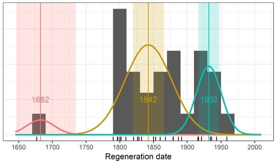
3.4. Regrowth Threshold and Disturbance Filters have a Large Impact on the Extent of Old-Growth Forest

Under the current definition of old growth (forest with at least one pre-1900 cohort, <10% regrowth canopy cover, and no evidence of medium- to high-severity disturbance), around 2.7% (1.4–4.9% range) of the Central Highlands area is classified as old-growth forest. The landscape area classified as old growth was highly sensitive to the regrowth canopy cover filtering criteria (Figure 3). Considering a less restrictive regrowth canopy cover threshold of 50% (while retaining the logging and fire filters), 9% of the study region would be considered old-growth forest. In the absence of any regrowth filtering (i.e., where the presence of one or more pre-1900 trees was sufficient for a pixel to be considered an old-growth forest), 15% of the landscape would be considered old-growth forest. The extent of the forest considered old growth increases to 20% if we remove the regrowth, logging, and fire filters (Figure 3). Our results highlight that a sizeable proportion of the landscape contains old-growth elements, many of which are not currently protected.

3.5. Giant Trees Are Located Close to Cool Temperate Rainforests and Cool Temperate Mixed Forests

We estimated that the study area contains approximately 2700 trees with DBH above 250 cm. Many of these giant trees are located near cool temperate rainforests and cool temperate mixed forests (Figure 4a). We quantified this finding by plotting the empirical cumulative distribution of trees >250 cm DBH vs. the distance to the closest cool temperate rainforests or cool temperate mixed forests (Figure 4b). Approximately 40% of trees >250 cm DBH are located within 20 m of these two forest types and 60% within 50 m. If giant trees were randomly dispersed within the landscape, we would have expected only 9% of trees to be within 20 m of cool temperate rainforests and cool temperate mixed forests and 18% within 50 m. This provides strong evidence that giant trees are disproportionally located in proximity to cool temperate rainforests and cool temperate mixed forests, which are typically associated with streamlines and topographically protected gullies.

4. Discussion

Under the current definition of old-growth forest in Victoria, we found that 2.7% (1.4–4.9% range) of the Central Highlands region is considered old growth and 37% is multi-aged. However, the percentage of the study region that was classified as an old-growth forest was highly sensitive to the percent regrowth and disturbance filters used in the rule-based classification.
The regrowth filter had the greatest impact on the amount of forest that is considered old growth with a near five-fold increase in area if the amount of allowable regrowth was increased from 10% to 80% (Figure 3). The fire filter had little impact as most fire-affected forests were already accounted for in the regrowth filter, which is a surrogate for fire impacts in the fire-sensitive forests of the study region [54]. Interestingly, filtering for logging did influence the area classified as old growth, suggesting that some areas that were historically logged using selective silvicultural systems might be able to maintain or even develop old-growth features over time [55,56]. The close association of giant trees near cool temperate rainforests and the higher relative abundance of old-growth forests in riparian and cool temperate rainforest EVCs highlight the importance of topography and landscape position on the occurrence of older trees and old-growth forests in the Central Highlands.
The LiDAR mapping of old-growth forests described here improves upon previous mapping methods (Table 2). Our approach delineates individual tree crowns, reconstructs tree age from tree size, and applies the existing rule-based classification [57] to identify a series of simplified forest growth stages. However, uncertainty accumulates in each estimation step across a multi-step workflow (Figure 1), and there is a relatively large range of old growth extent estimates (from 1.4 to 4.9%) that is consistent with our data and method. As more field validation data are collected over time, we may be able to use the validation plots to refine the different steps in our workflow and perhaps use supervised learning approaches to replace or refine some of the hard-coded rules for old growth classification.
A key finding from our analysis is that current rule-based definitions result in a sizeable proportion of the landscape containing old-growth elements that are unprotected by coarse-filter conservation planning (Figure 2). This arises due to the high proportion of the landscape (37%) that is multi-aged (Table 3) and the current definition of old-growth forest excluding most multi-aged forests from classification as old-growth forest due to regrowth canopy cover constraints. Increased amounts of regrowth are used as an indicator that a “greater than negligible disturbance” occurred in the past, that this disturbance altered the structure of the canopy, and that the impact is still measurable [10]. We argue that this definition is overly restrictive given the ecological importance of fire in the study landscape [58] and does not account for the underlying process of non-stand replacing disturbances that drive old-growth forest development and create the multi-layered canopies and multi-aged structures that are considered common features of old-growth forests in many parts of the world [9,14]. Additionally, in most old-growth definitions, the disturbance filters only apply to human disturbances (e.g., logging), whereas, in the Victorian definition, disturbance filters apply to both human (albeit not those induced by indigenous peoples prior to colonization) and natural disturbances (e.g., fires and the presence of a regrowth cohort indicative of past disturbances).
In ecosystems driven by infrequent but severe fires (i.e., return intervals of 60–150 years in the studied landscape [58,59]), discounting multi-aged forests with old-growth elements may lead to poor conservation outcomes. The finding that 20% of the landscape might contain trees that were established prior to 1900 aligns with a mean fire return interval for stand-replacing fires of around 75 years (see the approaches described in Nitschke and Innes [60] and Keenan and Nitschke [61]). In contrast, the current rule-based definition effectively assumes that stand-replacing fires have a return interval of around 30 years, which is not supported by existing modelling analyses (e.g., McCarthy, Malcolm Gill and Lindenmayer [58]) or measures of past fire occurrence in old-growth eucalypt stands (e.g., Fedrigo, Stewart, Kasel, Levchenko, Trouvé and Nitschke [19]). For example, Fedrigo, Stewart, Kasel, Levchenko, Trouvé and Nitschke [19] found that stands had experienced one to three non-stand replacing fires in the last 350 years with a mean fire return interval of 90 years (SD ± 25 years). This fire regime would result in 29% (range: 18 to 38%) of the landscape being multi-aged, which aligns with our findings that around 20% of the landscape has old-growth elements and 37% had a multi-aged structure. This includes around 30% of tall open wet forests (EVC30)—dominated by the quintessential obligate seeder Eucalyptus regnans—being multi-aged (see Table 3 and Table S4 in the Supplementary Materials). Spatial and temporal variation in disturbance intensity often leads to the survival of legacy trees, with larger trees more likely to survive subsequent fires [62]. The establishment of a new cohort below these legacy trees creates a multi-cohort stand with a complex structure [15,17].
Aligning a definition of old-growth forest with the expected occurrence of old-growth elements under observed fire regimes may provide a more robust approach to identifying and conserving these ecologically and culturally important forests. The Victorian government has a policy mandate to consider expanding the old-growth forest definition (and associated protections) to include mature stands with more than 10% but less than 50% regrowth. A 50% regrowth threshold would result in around 9% of the forest being protected, which is an improvement on the current 2.7% statistic. However, increasing the regrowth threshold to 80% would protect 20% of the forest landscape and would include more than 95% of stands with old-growth elements. Fine-filter management could then be employed in areas with >80% regrowth to protect large, old trees where management activities or fuel reduction burning are scheduled to occur. This approach would reorient the focus of protection towards a broader view of old-growth forest attributes rather than the current narrow definition based on stand age. This would greatly expand protections to important ecological elements across the Central Highlands and improve the provision of a range of ecosystem values [63].
Protecting the next generation of old-growth forests
A sizeable proportion of the forests within the study landscape (17%) was estimated to have regenerated between 1900 and 1920 (hereafter referred to as the pre-1920 cohort). This regeneration might be associated with large bushfires in 1905–06, 1912, and 1914 in the region. These trees and forests should be considered a priority for protection for two reasons. First, in the absence of further disturbances, the pre-1920 cohort will become the next generation of old growth to be recruited in the coming decades. As old growth is a stage in the dynamics of forest development [12], it is important to ensure that areas likely to become old growth in the near future are included in conservation planning that maintains multiple stages of stand development [64]. Second, the pre-1920 cohort provides a buffer against uncertainty in the old-growth forest classification. Based on the current calculations, a 20% error in the DBH growth rate could lead to an old-growth forest being classified as a pre-1920 forest (or vice versa). Protecting areas of forest dominated by the pre-1920 cohort would be a precautionary approach to buffer against statistical uncertainty in the estimation of old-growth forest extent.
Rainforests and Riparian Areas as coarse filters for conserving large, old trees
Spatial biases in the distribution of old-growth elements in the landscape allow for the supplementing of old-growth forest map protection by using a precautionary coarse-filter conservation measure. More than 60% of the giant trees in the region seem to be located within 50 m of cool temperate rainforests and cool temperate mixed forests (Figure 4). This pattern aligns with the cross-tabulations of old-growth forests vs. EVCs (Table 3), where old-growth forests were disproportionately represented in the riparian and cool temperate rainforest EVCs. Rainforests typically occur in the cooler, wetter portions of the landscape that are less prone to fire [36,65]. It is likely that these areas have longer return intervals for stand-replacing fires due to elevated fuel moisture and reduced flammability compared to areas solely dominated by eucalypts [66]. These areas, and other mesic riparian areas, were found to be the most likely places for fire refugia following the catastrophic Black Saturday fires of 2009 [35,65]. These areas might also be more productive (i.e., they grow large trees faster) and less likely to be harvested due to steeper slopes and forest practice regulations. Given the concentration of giant trees around these areas, adding a 50 m buffer around cool temperate rainforests and cool temperate mixed forests as mapped by Trouvé et al. [36] would provide high-conservation-value corridors of rainforest and giant trees interdigitated through large parts of the landscape.

5. Conclusions

We used landscape-scale airborne LiDAR and a rule-based classification system to develop a new approach to identifying and mapping forest growth stages, including old growth in the Central Highlands of Victoria, Australia. The total area of identified old-growth forest was greater than earlier estimates (2.7% in MOG-2022 vs. 1.7% in MOG-2009), although old-growth forests remains rare in the landscape. The total estimated area was particularly sensitive to the regrowth, fire, and logging-based disturbance filters that are used in the current definition of old-growth forests for the State of Victoria. In fact, we found that most of the uncertainty in old growth mapping came from the old growth definition, which is a human construct, not from the technical aspect of the work (i.e., the LiDAR data, ITD, and statistical analysis). The LiDAR analysis presented here provides high-resolution spatial data on forest and cohort structure across hundreds of thousands of hectares. It provides novel insights into the nature and distribution of old-growth forests in these landscapes. It also offers an empirical platform with which to re-evaluate and revise the existing definition of old-growth forests. Improved mapping of these forests, which have high conservation values and are rare within the landscape, will inform better conservation of old-growth forests in the region. Protecting old-growth stands and trees with ecologically mature features will improve conservation outcomes for fauna that depend on them, as well as the provision of ecosystem services such as carbon storage and water yield.

Supplementary Materials

The following supporting information can be downloaded at: https://www.mdpi.com/article/10.3390/rs16010147/s1, Figure S1: The linear model and R2 of HCB-HT relationship calibrated from field data; Figure S2: workflow for generating the top-edge-enhanced raster layer of CHM×DHP; Figure S3: Stem-mapped plots for validation of individual tree delineation (ITD) of tree crowns.; Figure S4: The relationship between field-measured crown width and crown width extracted from LiDAR; Figure S5: Stem-mapped plots for plot1-1939 regrowth forest of delineated tree crowns using: (a) traditional marker-control watershed segmentation method; (b) layer-stacking method; (c) localized contour method; and (d) lidR method; Figure S6: Location of the Central Highlands of Victoria in Australia (left panels) with a close up of the surveyed LiDAR area (right panel); Figure S7: Example of individual tree delineation in a 1939 regrowth plots Central Highlands of Victoria overlayed on the canopy height model (CHM, in meters); Figure S8: Relationship between DBH and LiDAR crown width in the Central Highlands area; Figure S9: Finite mixture modelling of cohort size; Figure S10: Cohort DBH growth as a function of annual heat moisture index; Figure S11: Map of simplified growth stage for the Central Highlands area; Figure S12: Conceptual diagram of uncertainty propagation using Monte Carlo simulations; Figure S13: Different ITD classification errors as a function of relative crown width; Table S1: The confusion matrix of ITD outputs and equations for each validation metrics; Table S2: Accuracy of individual tree delineation results for each plot; Table S3: Accuracy of individual tree delineation results for each method; Table S4: Partitioning of number of cohorts per hectares for the eight most common Ecological Vegetation Classes (EVC). Refs [2,4,28,29,31,33,40,41,48,55,57,58,64,65,66,67,68,69,70,71,72,73,74,75,76,77,78,79,80,81,82,83,84,85,86,87,88] are cited in the supplementary materials.

Author Contributions

Conceptualization, R.T. and C.R.N.; Methodology, R.T., R.J. and C.R.N.; Software, R.T. and R.J.; Formal analysis, R.T. and R.J.; Investigation, R.T., R.J., P.J.B., S.K. and C.R.N.; Writing—original draft, R.T.; Writing—review & editing, R.J., P.J.B., S.K. and C.R.N.; Supervision, P.J.B., S.K. and C.R.N.; Project administration, C.R.N.; Funding acquisition, P.J.B., S.K. and C.R.N. All authors have read and agreed to the published version of the manuscript.

Funding

This research was supported by the Department of Energy, Environment, and Climate Change (DEECA) through the Integrated Forest Ecosystem Research (IFER) program for C.R.N. and S.K. and through a supplementary IFER project grant to C.R.N., S.K., P.J.B. and R.T.

Data Availability Statement

Data is available upon request.

Acknowledgments

We sincerely thank the staff and students that collected the data. We also thank the two reviewers for providing constructive comments that helped improve the manuscript.

Conflicts of Interest

The authors declare no conflict of interest.

References

  1. Blicharska, M.; Mikusinski, G. Incorporating Social and Cultural Significance of Large Old Trees in Conservation Policy. Conserv. Biol. 2014, 28, 1558–1567. [Google Scholar] [CrossRef] [PubMed]
  2. Luyssaert, S.; Schulze, E.-D.; Börner, A.; Knohl, A.; Hessenmöller, D.; Law, B.; Ciais, P.; Grace, J. Old-growth forests as global carbon sinks. Nature 2008, 455, 213–215. [Google Scholar] [CrossRef] [PubMed]
  3. Watson, J.E.M.; Evans, T.; Venter, O.; Williams, B.; Tulloch, A.; Stewart, C.; Thompson, I.; Ray, J.C.; Murray, K.; Salazar, A.; et al. The exceptional value of intact forest ecosystems. Nat. Ecol. Evol. 2018, 2, 599–610. [Google Scholar] [CrossRef] [PubMed]
  4. Martin-Benito, D.; Pederson, N.; Férriz, M.; Gea-Izquierdo, G. Old forests and old carbon: A case study on the stand dynamics and longevity of aboveground carbon. Sci. Total Environ. 2021, 765, 142737. [Google Scholar] [CrossRef] [PubMed]
  5. Keenan, R.J.; Read, S.M. Assessment and management of old-growth forests in south eastern Australia. Plant Biosyst.—Int. J. Deal. All Asp. Plant Biol. 2012, 146, 214–222. [Google Scholar] [CrossRef]
  6. Lindenmayer, D.B. Old forest, new perspectives—Insights from the Mountain Ash forests of the Central Highlands of Victoria, south-eastern Australia. For. Ecol. Manag. 2009, 258, 357–365. [Google Scholar] [CrossRef]
  7. Lindenmayer, D.B.; Cunningham, R.; Donnelly, C.; Franklin, J. Structural features of old-growth Australian montane ash forests. For. Ecol. Manag. 2000, 134, 189–204. [Google Scholar] [CrossRef]
  8. Baker, S.C.; Kasel, S.; van Galen, L.G.; Jordan, G.J.; Nitschke, C.R.; Pryde, E.C. Identifying regrowth forests with advanced mature forest values. For. Ecol. Manag. 2019, 433, 73–84. [Google Scholar] [CrossRef]
  9. Wirth, C.; Messier, C.; Bergeron, Y.; Frank, D.; Fankhänel, A. Old-growth forest definitions: A pragmatic view. In Old-Growth Forests; Springer: Berlin/Heidelberg, Germany, 2009. [Google Scholar]
  10. Woodgate, P.W.; Peel, B.; Coram, J.; Farrell, S.; Ritman, K.; Lewis, A. Old-growth forest studies in Victoria, Australia Concepts and principles. For. Ecol. Manag. 1996, 85, 79–94. [Google Scholar] [CrossRef]
  11. Spies, T.A. Ecological concepts and diversity of old-growth forests. J. For. 2004, 102, 14–20. [Google Scholar]
  12. Oliver, C.D.; Larson, B.A. Forest Stand Dynamics; Yale School of the Environment: New York, NY, USA, 1996. [Google Scholar]
  13. Woodgate, P.W. A Study of the Old-Growth Forests of East Gippsland; Department of Conservation and Natural Resources: Melbourne, VIC, Australia, 1994. [Google Scholar]
  14. Burgman, M.A. Characterisation and delineation of the eucalypt old-growth forest estate in Australia: A review. For. Ecol. Manag. 1996, 83, 149–161. [Google Scholar] [CrossRef]
  15. Turner, P.A.M.; Balmer, J.; Kirkpatrick, J.B. Stand-replacing wildfires?: The incidence of multi-cohort and single-cohort Eucalyptus regnans and E. obliqua forests in southern Tasmania. For. Ecol. Manag. 2009, 258, 366–375. [Google Scholar] [CrossRef]
  16. Lindenmayer, D.; Taylor, C. Extensive recent wildfires demand more stringent protection of critical old growth forest. J. Pac. Conserv. Biol. 2020, 26, 384–394. [Google Scholar] [CrossRef]
  17. Ashton, D.H. The Big Ash forest, Wallaby Creek, Victoria; changes during one lifetime. Aust. J. Bot. 2000, 48, 1–26. [Google Scholar] [CrossRef]
  18. Simkin, R.; Baker, P.J. Disturbance history and stand dynamics in tall open forest and riparian rainforest in the Central Highlands of Victoria. Austral Ecol. 2008, 33, 747–760. [Google Scholar] [CrossRef]
  19. Fedrigo, M.; Stewart, S.B.; Kasel, S.; Levchenko, V.; Trouvé, R.; Nitschke, C.R. Radiocarbon dating informs tree fern population dynamics and disturbance history of temperate forests in southeast Australia. Radiocarbon 2018, 61, 445–460. [Google Scholar] [CrossRef]
  20. Australian and New Zealand Environment and Conservation Council; Australia Ministerial Council on Forestry, Fisheries and Aquaculture. Nationally Agreed Criteria for the Establishment of a Comprehensive, Adequate and Representative Reserve System for Forests in Australia; Joint Australian and New Zealand Environment and Conservation Council/Ministerial Council on Forestry: Canberra, ACT, Australia, 1997; p. 22. [Google Scholar]
  21. Collins, L.; Clarke, H.; Clarke, M.F.; Gausden, S.C.M.; Nolan, R.H.; Penman, T.; Bradstock, R. Warmer and drier conditions have increased the potential for large and severe fire seasons across south-eastern Australia. Glob. Ecol. Biogeogr. 2022, 31, 1933–1948. [Google Scholar] [CrossRef]
  22. Lim, K.; Treitz, P.; Wulder, M.; St-Onge, B.; Flood, M. LiDAR remote sensing of forest structure. Prog. Phys. Geogr. Earth Environ. 2003, 27, 88–106. [Google Scholar] [CrossRef]
  23. Næsset, E. Predicting forest stand characteristics with airborne scanning laser using a practical two-stage procedure and field data. Remote Sens. Environ. 2002, 80, 88–99. [Google Scholar] [CrossRef]
  24. Coops, N.C.; Tompalski, P.; Goodbody, T.R.; Queinnec, M.; Luther, J.E.; Bolton, D.K.; White, J.C.; Wulder, M.A.; van Lier, O.R.; Hermosilla, T. Modelling lidar-derived estimates of forest attributes over space and time: A review of approaches and future trends. Remote Sens. Environ. 2021, 260, 112477. [Google Scholar] [CrossRef]
  25. Hevia, A.; Calzado, A.; Alejano, R.; Vázquez-Piqué, J. Identification of old-growth Mediterranean forests using airborne laser scanning and geostatistical analysis. Remote Sens. 2022, 14, 4040. [Google Scholar] [CrossRef]
  26. Barros, L.A.; Elkin, C. An index for tracking old-growth value in disturbance-prone forest landscapes. Ecol. Indic. 2021, 121, 107175. [Google Scholar] [CrossRef]
  27. Spracklen, B.; Spracklen, D.V. Determination of Structural Characteristics of Old-Growth Forest in Ukraine Using Spaceborne LiDAR. Remote Sens. 2021, 13, 1233. [Google Scholar] [CrossRef]
  28. Martin, M.; Valeria, O. “Old” is not precise enough: Airborne laser scanning reveals age-related structural diversity within old-growth forests. Remote Sens. Environ. 2022, 278, 113098. [Google Scholar] [CrossRef]
  29. Fuhr, M.; Lalechère, E.; Monnet, J.; Bergès, L. Detecting overmature forests with airborne laser scanning (ALS). Remote Sens. Ecol. Conserv. 2022, 8, 731–743. [Google Scholar] [CrossRef]
  30. Hirschmugl, M.; Sobe, C.; Di Filippo, A.; Berger, V.; Kirchmeir, H.; Vandekerkhove, K. Review on the possibilities of mapping old-growth temperate forests by remote sensing in Europe. Environ. Model. Assess. 2023, 28, 761–785. [Google Scholar] [CrossRef]
  31. Sverdrup-Thygeson, A.; Ørka, H.O.; Gobakken, T.; Næsset, E. Can airborne laser scanning assist in mapping and monitoring natural forests? For. Ecol. Manag. 2016, 369, 116–125. [Google Scholar] [CrossRef]
  32. van der Ploeg, T.; Austin, P.C.; Steyerberg, E.W. Modern modelling techniques are data hungry: A simulation study for predicting dichotomous endpoints. BMC Med. Res. Methodol. 2014, 14, 137. [Google Scholar] [CrossRef]
  33. Gill, A.M. Eucalyptus and fires: Interdependent or independent? In Eucalypt Ecology: Individuals to Ecosystems; Williams, J.E., Woinarski, J.C.Z., Eds.; Cambridge University Press: Cambridge, UK, 1997; pp. 151–167. [Google Scholar]
  34. Crisp, M.D.; Burrows, G.E.; Cook, L.G.; Thornhill, A.H.; Bowman, D.M.J.S. Flammable biomes dominated by eucalypts originated at the Cretaceous–Palaeogene boundary. Nat. Commun. 2011, 2, 193. [Google Scholar] [CrossRef]
  35. Berry, L.E.; Driscoll, D.A.; Banks, S.C.; Lindenmayer, D.B. The use of topographic fire refuges by the greater glider (Petauroides volans) and the mountain brushtail possum (Trichosurus cunninghami) following a landscape-scale fire. J. Aust. Mammal. 2015, 37, 39–45. [Google Scholar] [CrossRef]
  36. Trouvé, R.; Jiang, R.; Fedrigo, M.; White, M.D.; Kasel, S.; Baker, P.J.; Nitschke, C.R. Combining Environmental, Multispectral, and LiDAR Data Improves Forest Type Classification: A Case Study on Mapping Cool Temperate Rainforests and Mixed Forests. Remote Sens. Environ. 2023, 15, 60. [Google Scholar] [CrossRef]
  37. DEECA. 2015-16 Central Highlands LiDAR Project. Department of Energy, Environment and Climate Action. 2016. Available online: https://dev-metashare.maps.vic.gov.au/geonetwork/srv/eng/catalog.search#/metadata/c68b1084-e8f3-5c9c-851b-b58f32f1c9a5. (accessed on 10 October 2023).
  38. Jiang, R. Using LiDAR for Landscape-Scale Mapping of Potential Habitat for the Critically Endangered Leadbeater’s Possum, in School of Ecosystem and Forest Sciences. Ph.D. thesis, The University of Melbourne, Victoria, VIC, Australia, 2019. [Google Scholar]
  39. Kwak, D.-A.; Lee, W.-K.; Lee, J.-H.; Biging, G.S.; Gong, P. Detection of individual trees and estimation of tree height using LiDAR data. J. For. Res. 2007, 12, 425–434. [Google Scholar] [CrossRef]
  40. Amiri, N. Assessment of Marker-Controlled Watershed Segmentation Algorithm for Individual Tree Top Detection and Crown Delineation. Master’s Thesis, University of Twente, Enschede, The Netherlands, 2014. [Google Scholar]
  41. Kalapala, M.; Rao, V.S.; Srinivas, K. Robust Tree Crown Delineation using Novel Marker Controlled Watershed Segmentation Algorithm. Int. J. Eng. Res. Technol. 2012, 1, 7. [Google Scholar]
  42. Ayrey, E.; Fraver, S.; Kershaw, J.A., Jr.; Kenefic, L.S.; Hayes, D.; Weiskittel, A.R.; Roth, B.E. Layer Stacking: A Novel Algorithm for Individual Forest Tree Segmentation from LiDAR Point Clouds. Can. J. Remote Sens. 2017, 43, 16–27. [Google Scholar] [CrossRef]
  43. Ma, K.; Chen, Z.; Fu, L.; Tian, W.; Jiang, F.; Yi, J.; Du, Z.; Sun, H. Performance and sensitivity of individual tree segmentation methods for UAV-LiDAR in multiple forest types. Remote Sens. 2022, 14, 298. [Google Scholar] [CrossRef]
  44. Wu, B.; Yu, B.; Wu, Q.; Huang, Y.; Chen, Z.; Wu, J. Individual tree crown delineation using localized contour tree method and airborne LiDAR data in coniferous forests. Int. J. Appl. Earth Obs. Geoinf. 2016, 52, 82–94. [Google Scholar] [CrossRef]
  45. Dalponte, M.; Coomes, D.A. Tree-centric mapping of forest carbon density from airborne laser scanning and hyperspectral data. Methods Ecol. Evol. 2016, 7, 1236–1245. [Google Scholar] [CrossRef]
  46. Jiang, R. Individual Tree Delineation in Broadleaf Forest. 2023. Available online: https://github.com/ruizhuj/Individual_Tree_Delineation_in_Broadleaf_forest/blob/main/README.md (accessed on 21 August 2023).
  47. Trouvé, R.; Nitschke, C.R.; Robinson, A.P.; Baker, P.J. Estimating the self-thinning line from mortality data. For. Ecol. Manag. 2017, 402, 122–134. [Google Scholar] [CrossRef]
  48. Nitschke, C.R.; Nichols, S.; Allen, K.; Dobbs, C.; Livesley, S.J.; Baker, P.J.; Lynch, Y. The influence of climate and drought on urban tree growth in southeast Australia and the implications for future growth under climate change. Landsc. Urban Plan. 2017, 167, 275–287. [Google Scholar] [CrossRef]
  49. Chick, R.; Molloy, J. Forest Protection Survey Program, Survey Guideline, Coupe Habitat and Sign Survey (V4); Department of Energy, Environment and Climate Action (DEECA): Melbourne, VIC, Australia, 2020; p. 10. [Google Scholar]
  50. Kuhn, M. Building predictive models in R using the caret package. J. Stat. Softw. 2008, 28, 1–26. [Google Scholar] [CrossRef]
  51. Landis, J.R.; Koch, G.G. The Measurement of Observer Agreement for Categorical Data. Biometrics 1977, 1, 159–174. [Google Scholar] [CrossRef]
  52. Allouche, O.; Asaf, T.; Ronen, R. Assessing the accuracy of species distribution models: Prevalence, Kappa and the True Skill Statistic (TSS). J. Appl. Ecol. 2006, 43, 1223–1232. [Google Scholar] [CrossRef]
  53. Foody, G.M. Explaining the unsuitability of the kappa coefficient in the assessment and comparison of the accuracy of thematic maps obtained by image classification. Remote Sens. Environ. 2020, 239, 111630. [Google Scholar] [CrossRef]
  54. Fairman, T.A.; Nitschke, C.R.; Bennett, L.T. Too much, too soon? A review of the effects of increasing wildfire frequency on tree mortality and regeneration in temperate eucalypt forests. Int. J. Wildland Fire 2016, 25, 831–848. [Google Scholar] [CrossRef]
  55. Orwig, D.A.; Abrams, M.D. Impacts of Early Selective Logging on the Dendroecology of an Old-Growth, Bottomland Hemlock-White Pine-Northern Hardwood Forest on the Allegheny Plateau. J. Torrey Bot. Soc. 1999, 126, 234–244. [Google Scholar] [CrossRef]
  56. Ding, Y.; Zang, R.; Lu, X.; Huang, J. The impacts of selective logging and clear-cutting on woody plant diversity after 40years of natural recovery in a tropical montane rain forest, south China. Sci. Total Environ. 2017, 579, 1683–1691. [Google Scholar] [CrossRef] [PubMed]
  57. DEECA. Old Growth Forest Identification Assessment Tool; Department of Energy, Environment and Climate Action, Conservation Regulator: Melbourne, VIC, Australia, 2020. [Google Scholar]
  58. McCarthy, M.A.; Malcolm Gill, A.; Lindenmayer, D.B. Fire regimes in mountain ash forest: Evidence from forest age structure, extinction models and wildlife habitat. For. Ecol. Manag. 1999, 124, 193–203. [Google Scholar] [CrossRef]
  59. Nitschke, C.R.; Trouvé, R.; Lumsden, L.F.; Bennett, L.T.; Fedrigo, M.; Robinson, A.P.; Baker, P.J. Spatial and temporal dynamics of habitat availability and stability for a critically endangered arboreal marsupial: Implications for conservation planning in a fire-prone landscape. Landsc. Ecol. 2020, 35, 1553–1570. [Google Scholar] [CrossRef]
  60. Nitschke, C.R.; Innes, J.L. Potential effect of climate change on observed fire regimes in the Cordilleran forests of South-Central Interior, British Columbia. Clim. Change 2013, 116, 579–591. [Google Scholar] [CrossRef]
  61. Keenan, R.J.; Nitschke, C. Forest management options for adaptation to climate change: A case study of tall, wet eucalypt forests in Victoria’s Central Highlands region. Aust. For. 2016, 79, 96–107. [Google Scholar] [CrossRef]
  62. Trouvé, R.; Oborne, L.; Baker, P.J. The effect of species, size, and fire intensity on tree mortality within a catastrophic bushfire complex. Ecol. Appl. 2021, 31, e2383. [Google Scholar] [CrossRef] [PubMed]
  63. Barros, L.A.; Venter, M.; Elkin, C.; Venter, O. Managing forests for old-growth attributes better promotes the provision of ecosystem services than current age-based old-growth management. For. Ecol. Manag. 2022, 511, 120130. [Google Scholar] [CrossRef]
  64. McCarter, J.B.; Wilson, J.S.; Baker, P.J.; Moffett, J.L.; Oliver, C.D. Landscape management through integration of existing tools and emerging technologies. J. For. 1998, 96, 17–23. [Google Scholar]
  65. Berry, L.E.; Driscoll, D.A.; Stein, J.A.; Blanchard, W.; Banks, S.C.; Bradstock, R.A.; Lindenmayer, D.B. Identifying the location of fire refuges in wet forest ecosystems. Ecol. Appl. 2015, 25, 2337–2348. [Google Scholar] [CrossRef] [PubMed]
  66. Tng, D.Y.P.; Williamson, G.J.; Jordan, G.J.; Bowman, D.M.J.S. Giant eucalypts—globally unique fire-adapted rain-forest trees? New Phytol. 2012, 196, 1001–1014. [Google Scholar] [CrossRef] [PubMed]
  67. Dalponte, M.; Orka, H.O.; Ene, L.T.; Gobakken, T.; Naesset, E. Tree crown delineation and tree species classification in boreal forests using hyperspectral and als data. Remote Sens. Environ. 2014, 140, 306–317. [Google Scholar] [CrossRef]
  68. Wang, L.; Gong, P.; Biging, G.S. Individual tree-crown delineation and treetop detection in high-spatial-resolution aerial imagery. Photogramm. Eng. Remote Sens. 2004, 70, 351–357. [Google Scholar] [CrossRef]
  69. Popescu, S.C.; Wynne, R.H.; Nelson, R.F. Estimating plot-level tree heights with lidar: Local filtering with a canopy-height based variable window size. Comput. Electron. Agric. 2002, 37, 71–95. [Google Scholar] [CrossRef]
  70. Soille, P. Morphological Image Analysis: Principles and Applications; Springer Science & Business Media: Berlin/Heidelberg, Germany, 2013. [Google Scholar]
  71. Ke, Y.H.; Quackenbush, L.J. A review of methods for automatic individual tree-crown detection and delineation from passive remote sensing. Int. J. Remote Sens. 2011, 32, 4725–4747. [Google Scholar] [CrossRef]
  72. Rahman, M.; Gorte, B.; Bucksch, A. A new method for individual tree measurement from airborne lidar. In Proceedings of the SilviLaser 2009, College Station, TX, USA, 14–16 October 2009. [Google Scholar]
  73. Rahman, M.A.; Gorte, B. Individual tree detection based on densities of high points of high resolution airborne lidar. In Proceedings of the GEOBIA 2008, Calgary, AB, Canada, 5–8 August 2008; pp. 350–355. [Google Scholar]
  74. Rahman, M.; Gorte, B. Tree crown delineation from high resolution airborne lidar based on densities of high points. ISPRS 2009, XXXVIII, 123–128. [Google Scholar]
  75. Ritchie, M.W.; Hann, D.W. Equations for Predicting Height to Crown Base for Fourteen Tree Species in Southwest Oregon; Forest Research Laboratory, College of Forestry, Oregon State University: Corvallis, OR, USA, 1987. [Google Scholar]
  76. Nutto, L.; Spathelf, P.; Seling, I. Management of individual tree diameter growth and implications for pruning for brazilian eucalyptus grandis hill ex maiden. Floresta 2006, 36, 397–413. [Google Scholar] [CrossRef]
  77. Rijal, B.; Weiskittel, A.R.; Kershaw, J.A. Development of height to crown base models for thirteen tree species of the north american acadian region. For. Chron. 2012, 88, 60–73. [Google Scholar] [CrossRef]
  78. Sharma, R.P.; Vacek, Z.; Vacek, S.; Podrázský, V.; Jansa, V. Modelling individual tree height to crown base of norway spruce (Picea abies (L.) karst.) and european beech (Fagus sylvatica L.). PLoS ONE 2017, 12, e0186394. [Google Scholar] [CrossRef] [PubMed]
  79. Persson, A.; Holmgren, J.; Söderman, U. Detecting and measuring individual trees using an airborne laser scanner. Photogramm. Eng. Remont Sens. 2002, 68, 925–932. [Google Scholar]
  80. Wulder, M.; Niemann, K.O.; Goodenough, D.G. Local maximum filtering for the extraction of tree locations and basal area from high spatial resolution imagery. Remote Sens. Environ. 2000, 73, 103–114. [Google Scholar] [CrossRef]
  81. Popescu, S.C.; Wynne, R.H. Seeing the trees in the forest. Photogramm. Eng. Remote Sens. 2004, 70, 589–604. [Google Scholar] [CrossRef]
  82. Brandtberg, T.; Walter, F. Automated delineation of individual tree crowns in high spatial resolution aerial images by multiple-scale analysis. Mach. Vis. Appl. 1998, 11, 64–73. [Google Scholar] [CrossRef]
  83. Dralle, K.; Rudemo, M. Stem number estimation by kernel smoothing of aerial photos. Can. J. For. Res. 1996, 26, 1228–1236. [Google Scholar] [CrossRef]
  84. Xu, X.; Iuricich, F.; De Floriani, L. A topology-based approach to individual tree segmentation from airborne lidar data. GeoInformatica 2023, 27, 759–788. [Google Scholar] [CrossRef]
  85. Sačkov, I.; Hlásny, T.; Bucha, T.; Juriš, M. Integration of tree allometry rules to treetops detection and tree crowns delineation using airborne lidar data. Iforest-Biogeosci. For. 2017, 10, 459. [Google Scholar] [CrossRef]
  86. Roussel, J.-R.; Auty, D.; Coops, N.C.; Tompalski, P.; Goodbody, T.R.; Meador, A.S.; Bourdon, J.-F.; De Boissieu, F.; Achim, A. Lidr: An r package for analysis of airborne laser scanning (als) data. Remote Sens. Environ. 2020, 251, 112061. [Google Scholar] [CrossRef]
  87. Huisman, J.; Olff, H.; Fresco, L.F.M. A hierarchical set of models for species response analysis. J. Veg. Sci. 1993, 4, 37–46. [Google Scholar] [CrossRef]
  88. Ashton, D. The development of even-aged stands of eucalyptus regnans f. Muell. In central victoria. Aust. J. Bot. 1976, 24, 397–414. [Google Scholar] [CrossRef]
Figure 1. Conceptual workflow of the study. The primary objective of the study was the mapping of old-growth forests in the region (shaded grey area). Additionally, we used Monte Carlo simulations to provide an uncertainty range for the old-growth extent, and we analyzed the sensitivity of the old-growth extent to the details of the definition of old-growth forest. The study also quantified the proportion of multi-aged forests in the landscape (i.e., number of cohorts per ha) and the spatial relationship between giant eucalypt trees (>250 cm DBH) and cool temperate rainforests and cool temperate mixed forests.
Remotesensing 16 00147 g001
Figure 2. Location of the Central Highlands of Victoria in Australia (left panels), and simplified growth stages map derived from the multi-stage analysis of tree size and stand cohort structure (right panel).
Remotesensing 16 00147 g002
Figure 3. Influence of the definition of old-growth forest on the landscape area classified as old-growth forest. The definitions vary in terms of the inclusion of (i.e., with and without) logging and wildfire disturbances and regrowth canopy cover threshold, where 100% regrowth canopy cover qualifies as old growth, and at least one pre-1900 tree per ha must also occur.
Remotesensing 16 00147 g003
Figure 4. (a) Location of giant trees estimated in this study relative to a map of cool temperate rainforests (CTRFs), cool temperate mixed forests (CTMFs), and tree fern dominated areas [36] for a 4500 ha subsection of the overall study landscape. (b) Empirical cumulative distribution of giant trees relative to the distance to CTRF and CTMF (whichever is closest). The red line is the observed distribution; the light blue line is the expected distribution if giant trees were dispersed randomly across the landscape.
Remotesensing 16 00147 g004
Table 1. Simplified growth stage classes’ definition (on a per ha basis).
Simplified Growth StageDefinition
Old growthThe stand has at least one pre-1900 cohort and there is no visible disturbance trace. This means less than 10% regrowth crown cover (i.e., trees that were established after 1900), and being outside the footprint of fire (canopy burn and crown scorch) and logging disturbances is defined using GIS layers. This old growth stage is referred to as modelled old growth (MOG-2022) in this study.
Multi-agedStands with several cohorts that may or may not be ecologically mature.
Pre-1920Single cohort stands that regenerated between 1900 and 1920 and that have the potential to be next-generation old growth.
RegrowthSingle cohort stands that regenerated after 1920.
Table 2. Confusion matrix and goodness of fit metrics for the MOG-2022 and the MOG-2009 models vs. field validation.
Field Validation (Observed)
01KappaSensitivitySpecificityPrecisionTSS 1
PredictedMOG-202204240.560.431.001.000.43
103
MOG-200903650.130.270.860.250.13
162
1 TSS, True skill statistic.
Table 3. Partitioning of simplified growth stages for the eight most common Ecological Vegetation Classes (EVC) in the Central Highlands region of Victoria, Australia, evaluated in this study.
Simplified Growth Stage
EVC (ha)RegrowthMulti-AgedPre-1920Old GrowthTotal (ha)Total (%)
EVC 29: damp forest44,03341,55811,316172698,63329.2
EVC 30: wet forest48,43228,89116,878367897,87929.0
EVC 39: montane Wet Forest16,98115,2576396117339,80711.8
EVC 23: herb-rich foothill forest12,4049859138411223,7597.0
EVC 45: Shrubby Foothill Forest 642510,654113615818,3735.4
EVC 18: riparian forest641449903762108116,2474.8
EVC 38: montane damp forest9694502711538315,9574.7
EVC 31: cool temperate rainforest39612418333796510,6813.2
Others EVCs68357359174027816,2124.8
Total (ha)154,898125,95947,1029589337,548
Total (%)46.037.314.02.7 100.0
Disclaimer/Publisher’s Note: The statements, opinions and data contained in all publications are solely those of the individual author(s) and contributor(s) and not of MDPI and/or the editor(s). MDPI and/or the editor(s) disclaim responsibility for any injury to people or property resulting from any ideas, methods, instructions or products referred to in the content.

