

Optimizing Image Compression Ratio for Generating Highly Accurate Local Digital Terrain Models: Experimental Study for Martian Moons eXploration Mission

Abstract
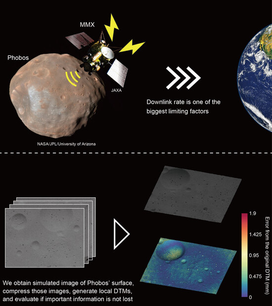
:
1. Introduction
2. Materials and Methods
2.1. Experimental Setup
2.2. Image Compression
2.3. Image Quality Assessment
2.4. Generation of Local DTMs
- Import images and image masks (i.e., binary images determining the processing areas) and set camera parameters (e.g., focal length and sensor pixel sizes).
- Georeference cameras by importing camera coordinate files, which define positions (coordinates) and orientations (directions) for each camera.
- Perform key point matching by identifying distinctive features in images that can be recognized in other images and matching the most prominent features across the image dataset.
- Perform bundle adjustment for three-dimensional geometry reconstruction using the network of matched features, incrementally adding images to update camera model parameters (e.g., focal length, radial distortion parameters) and camera orientations (i.e., positions, directions), and calculating three-dimensional coordinates for key points.
- Generate a sparse point cloud representing the three-dimensional coordinates of the most prominent features in the image dataset, realign images with large coordinate errors, and remove outliers by observing the point cloud from various directions.
- Build a dense point cloud by calculating depth and color information for each camera.
- Generate polygon meshes from the dense point cloud that express a detailed topography of the target shape.
- Generate image masks by selecting areas on the mesh with high confidence, created from many points in the dense point cloud. Using those image masks, regenerate the model.
- Generate the model’s texture by combining the original images seamlessly with the reconstructed polygon meshes.
3. Results
3.1. Phobos Simulated Images and Local DTMs
3.2. Influence of Image Compressions
4. Discussion
4.1. Effect of Image Compression on the Accuracy of Generating Local DTMs
4.2. Implications for the Observation in the MMX Mission
5. Conclusions
Author Contributions
Funding
Data Availability Statement
Conflicts of Interest
References
- Saito, J.; Miyamoto, H.; Nakamura, R.; Ishiguro, M.; Michikami, T.; Nakamura, A.M.; Demura, H.; Sasaki, S.; Hirata, N.; Honda, C.; et al. Detailed images of asteroid 25143 Itokawa from Hayabusa. Science 2006, 312, 1341–1344. [Google Scholar] [CrossRef]
- Watanabe, S.; Tsuda, Y.; Yoshikawa, M.; Tanaka, S.; Saiki, T.; Nakazawa, S. Hayabusa2 Mission Overview. Space Sci. Rev. 2017, 208, 3–16. [Google Scholar] [CrossRef]
- Glassmeier, K.H.; Boehnhardt, H.; Koschny, D.; Kuhrt, E.; Richter, I. The ROSETTA Mission: Flying towards the origin of the solar system. Space Sci. Rev. 2007, 128, 1–21. [Google Scholar] [CrossRef]
- Lauretta, D.S.; Balram-Knutson, S.S.; Beshore, E.; Boynton, W.V.; d’Aubigny, C.D.; DellaGiustina, D.N.; Enos, H.L.; Golish, D.R.; Hergenrother, C.W.; Howell, E.S.; et al. OSIRIS-REx: Sample Return from Asteroid (101955) Bennu. Space Sci. Rev. 2017, 212, 925–984. [Google Scholar] [CrossRef]
- Lord, P.; Tilley, S.; Oh, D.Y.; Goebel, D.; Polanskey, C.; Snyder, S.; Carr, G.; Collins, S.M.; Lantoine, G.; Landau, D.; et al. Psyche: Journey to a Metal World. In Proceedings of the IEEE Aerospace Conference, Big Sky, MT, USA, 4–11 March 2017. [Google Scholar]
- Lorenz, R.D.; MacKenzie, S.M.; Neish, C.D.; Gall, A.L.; Turtle, E.P.; Barnes, J.W.; Trainer, M.G.; Werynski, A.; Hedgepeth, J.; Karkoschka, E. Selection and Characteristics of the Dragonfly Landing Site near Selk Crater, Titan. Planet. Sci. J. 2021, 2, 24. [Google Scholar] [CrossRef]
- Levison, H.F.; Olkin, C.B.; Noll, K.S.; Marchi, S.; Bell, J.; Bierhaus, E.; Binzel, R.; Bottke, W.; Britt, D.; Brown, M.; et al. Lucy Mission to the Trojan Asteroids: Science Goals. Planet. Sci. J. 2021, 2, 171. [Google Scholar] [CrossRef]
- Michel, P.; Kuppers, M.; Bagatin, A.C.; Carry, B.; Charnoz, S.; de Leon, J.; Fitzsimmons, A.; Gordo, P.; Green, S.F.; Herique, A.; et al. The ESA Hera Mission: Detailed Characterization of the DART Impact Outcome and of the Binary Asteroid (65803) Didymos. Planet. Sci. J. 2022, 3, 160. [Google Scholar] [CrossRef]
- Kuramoto, K.; Kawakatsu, Y.; Fujimoto, M.; Araya, A.; Barucci, M.A.; Genda, H.; Hirata, N.; Ikeda, H.; Imamura, T.; Helbert, J.; et al. Martian moons exploration MMX: Sample return mission to Phobos elucidating formation processes of habitable planets. Earth Planets Space 2022, 74, 12. [Google Scholar] [CrossRef]
- Pollack, J.B.; Veverka, J.; Pang, K.; Colburn, D.; Lane, A.L.; Ajello, J.M. Multicolor observations of Phobos with the Viking Lander cameras: Evidence for a carbonaceous chondritic composition. Science 1978, 199, 66–69. [Google Scholar] [CrossRef]
- Hartmann, W.K. Additional Evidence about An Early Intense Flux of C-asteroids and The Origin of Phobos. Icarus 1990, 87, 236–240. [Google Scholar] [CrossRef]
- Pajola, M.; Lazzarin, M.; Ore, C.M.D.; Cruikshank, D.P.; Roush, T.L.; Magrin, S.; Bertini, I.; La Forgia, F.; Barbieri, C. Phobos as A D-type Captured Asteroid, Spectral Modeling from 0.25 to 4.0 μm. Astrophys. J. 2013, 777, 127. [Google Scholar] [CrossRef]
- Burns, J.A. Contradictory clues as to the origin of the Martian moons. In Mars; Kieffer, H.H., Jakosky, B.M., Snyder, C.W., Matthews, M.S., Eds.; University of Arizona Press: Tucson, AZ, USA, 1992; pp. 1283–1301. [Google Scholar]
- Citron, R.I.; Genda, H.; Ida, S. Formation of Phobos and Deimos via a giant impact. Icarus 2015, 252, 334–338. [Google Scholar] [CrossRef]
- Craddock, R.A. Are Phobos and Deimos the result of a giant impact? Icarus 2011, 211, 1150–1161. [Google Scholar] [CrossRef]
- Hyodo, R.; Genda, H.; Charnoz, S.; Rosenblatt, P. On the Impact Origin of Phobos and Deimos. I. Thermodynamic and Physical Aspects. Astrophys. J. 2017, 845, 125. [Google Scholar] [CrossRef]
- Hyodo, R.; Rosenblatt, P.; Genda, H.; Charnoz, S. On the Impact Origin of Phobos and Deimos. II. True Polar Wander and Disk Evolution. Astrophys. J. 2017, 851, 122. [Google Scholar] [CrossRef]
- Hyodo, R.; Genda, H.; Charnoz, S.; Pignatale, F.C.F.; Rosenblatt, P. On the Impact Origin of Phobos and Deimos. IV. Volatile Depletion. Astrophys. J. 2018, 860, 150. [Google Scholar] [CrossRef]
- Pignatale, F.C.; Charnoz, S.; Rosenblatt, P.; Hyodo, R.; Nakamura, T.; Genda, H. On the Impact Origin of Phobos and Deimos. III. Resulting Composition from Different Impactors. Astrophys. J. 2018, 853, 118. [Google Scholar] [CrossRef]
- Nakamura, T.; Ikeda, H.; Kouyama, T.; Nakagawa, H.; Kusano, H.; Senshu, H.; Kameda, S.; Matsumoto, K.; Gonzalez-Franquesa, F.; Ozaki, N.; et al. Science operation plan of Phobos and Deimos from the MMX spacecraft. Earth Planets Space 2021, 73, 227. [Google Scholar] [CrossRef]
- Willner, K.; Shi, X.; Oberst, J. Phobos’ shape and topography models. Planet. Space Sci. 2014, 102, 51–59. [Google Scholar] [CrossRef]
- Asphaug, E.; Melosh, H.J. The Stickney impact of Phobos: A dynamical model. Icarus 1993, 101, 144–164. [Google Scholar] [CrossRef]
- Basilevsky, A.T.; Lorenz, C.A.; Shingareva, T.V.; Head, J.W.; Ramsley, K.R.; Zubarev, A.E. The surface geology and geomorphology of Phobos. Planet. Space Sci. 2014, 102, 95–118. [Google Scholar] [CrossRef]
- Karachevtseva, I.P.; Oberst, J.; Zubarev, A.E.; Nadezhdina, I.E.; Kokhanov, A.A.; Garov, A.S.; Uchaev, D.V.; Malinnikov, V.A.; Klimkin, N.D. The Phobos information system. Planet. Space Sci. 2014, 102, 74–85. [Google Scholar] [CrossRef]
- Salamuniccar, G.; Loncaric, S.; Pina, P.; Bandeira, L.; Saraiva, J. Integrated Crater Detection Algorithm and Systematic Cataloging of Phobos Craters. In Proceedings of the 7th International Symposium on Image and Signal Processing and Analysis (Ispa 2011), Dubrovnik, Croatia, 4–6 September 2011; pp. 591–596. [Google Scholar]
- Salamuniccar, G.; Loncaric, S.; Pina, P.; Bandeira, L.; Saraiva, J. Integrated method for crater detection from topography and optical images and the new PH9224GT catalogue of Phobos impact craters. Adv. Space Res. 2014, 53, 1798–1809. [Google Scholar] [CrossRef]
- Schmedemann, N.; Michael, G.G.; Ivanov, B.A.; Murray, J.B.; Neukum, G. The age of Phobos and its largest crater, Stickney. Planet. Space Sci. 2014, 102, 152–163. [Google Scholar] [CrossRef]
- Thomas, P.C.; Veverka, J.; Sullivan, R.; Simonelli, D.P.; Malin, M.C.; Caplinger, M.; Hartmann, W.K.; James, P.B. Phobos: Regolith and ejecta blocks investigated with Mars Orbiter Camera images. J. Geophys. Res. Planets 2000, 105, 15091–15106. [Google Scholar] [CrossRef]
- Murray, J.B.; Heggie, D.C. Character and origin of Phobos’ grooves. Planet. Space Sci. 2014, 102, 119–143. [Google Scholar] [CrossRef]
- Wilson, L.; Head, J.W. Groove formation on Phobos: Testing the Stickney ejecta emplacement model for a subset of the groove population. Planet. Space Sci. 2015, 105, 26–42. [Google Scholar] [CrossRef]
- Thomas, P.; Veverka, J.; Bloom, A.; Duxbury, T. Grooves on Phobos—Their Distribution, Morphology and Possible Origin. J. Geophys. Res. 1979, 84, 8457–8477. [Google Scholar] [CrossRef]
- Andert, T.P.; Rosenblatt, P.; Patzold, M.; Hausler, B.; Dehant, V.; Tyler, G.L.; Marty, J.C. Precise mass determination and the nature of Phobos. Geophys. Res. Lett. 2010, 37, 4. [Google Scholar] [CrossRef]
- Ballouz, R.L.; Walsh, K.J.; Sanchez, P.; Holsapple, K.A.; Michel, P.; Scheeres, D.J.; Zhang, Y.; Richardson, D.C.; Barnouin, O.S.; Nolan, M.C.; et al. Modified granular impact force laws for the OSIRIS-REx touchdown on the surface of asteroid (101955) Bennu. Mon. Not. R. Astron. Soc. 2021, 507, 5087–5105. [Google Scholar] [CrossRef]
- Terui, F.; Ogawa, N.; Ono, G.; Yasuda, S.; Masuda, T.; Matsushima, K.; Saiki, T.; Tsuda, Y. Guidance, navigation, and control of Hayabusa2 touchdown operations. Astrodynamics 2020, 4, 393–409. [Google Scholar] [CrossRef]
- Walsh, K.J.; Ballouz, R.L.; Jawin, E.R.; Avdellidou, C.; Barnouin, O.S.; Bennett, C.A.; Bierhaus, E.B.; Bos, B.J.; Cambioni, S.; Connolly, H.C.; et al. Near-zero cohesion and loose packing of Bennu’s near subsurface revealed by spacecraft contact. Sci. Adv. 2022, 8, eabm6229. [Google Scholar] [CrossRef]
- Kawaguchi, J.I.; Fujiwara, A.; Uesugi, T. Hayabusa—Its technology and science accomplishment summary and Hayabusa-2. Acta Astronaut. 2008, 62, 639–647. [Google Scholar] [CrossRef]
- Yoshikawa, K.; Sawada, H.; Kikuchi, S.; Ogawa, N.; Mimasu, Y.; Ono, G.; Takei, Y.; Terui, F.; Saiki, T.; Yasuda, S.; et al. Modeling and analysis of Hayabusa2 touchdown. Astrodynamics 2020, 4, 119–135. [Google Scholar] [CrossRef]
- Takemura, T.; Miyamoto, H.; Hemmi, R.; Niihara, T.; Michel, P. Small-scale topographic irregularities on Phobos: Image and numerical analyses for MMX mission. Earth Planets Space 2021, 73, 213. [Google Scholar] [CrossRef]
- Pollack, J.B.; Born, G.H.; Smith, B.A.; Veverka, J.; Sagan, C.; Duxbury, T.C.; Milton, D.J.; Hartmann, W.K.; Noland, M. Mariner 9 Television Observations of Phobos and Deimos. Icarus 1972, 17, 394–407. [Google Scholar] [CrossRef]
- Veverka, J.; Duxbury, T.C. Viking observations of Phobos and Deimos: Preliminary results. J. Geophys. Res. 1977, 82, 4213–4223. [Google Scholar] [CrossRef]
- Witasse, O.; Duxbury, T.; Chicarro, A.; Altobelli, N.; Andert, T.; Aronica, A.; Barabash, S.; Bertaux, J.L.; Bibring, J.P.; Cardesin-Moinelo, A.; et al. Mars Express investigations of Phobos and Deimos. Planet. Space Sci. 2014, 102, 18–34. [Google Scholar] [CrossRef]
- Thomas, N.; Stelter, R.; Ivanov, A.; Bridges, N.T.; Herkenhoff, K.E.; McEwen, A.S. Spectral heterogeneity on Phobos and Deimos: HiRISE observations and comparisons to Mars Pathfinder results. Planet. Space Sci. 2011, 59, 1281–1292. [Google Scholar] [CrossRef]
- Amiri, H.E.S.; Brain, D.; Sharaf, O.; Withnell, P.; McGrath, M.; Alloghani, M.; Al Awadhi, M.; Al Dhafri, S.; Al Hamadi, O.; Al Matroushi, H.; et al. The Emirates Mars Mission. Space Sci. Rev. 2022, 218, 46. [Google Scholar] [CrossRef] [PubMed]
- Kameda, S.; Ozaki, M.; Enya, K.; Fuse, R.; Kouyama, T.; Sakatani, N.; Suzuki, H.; Osada, N.; Kato, H.; Miyamoto, H.; et al. Design of telescopic nadir imager for geomorphology (TENGOO) and observation of surface reflectance by optical chromatic imager (OROCHI) for the Martian Moons Exploration (MMX). Earth Planets Space 2021, 73, 218. [Google Scholar] [CrossRef]
- Ishiguro, M.; Nakamura, R.; Tholen, D.J.; Hirata, N.; Demura, H.; Nemoto, E.; Nakamura, A.M.; Higuchi, Y.; Sogame, A.; Yamamoto, A.; et al. The Hayabusa Spacecraft Asteroid Multi-band Imaging Camera (AMICA). Icarus 2010, 207, 714–731. [Google Scholar] [CrossRef]
- Kameda, S.; Suzuki, H.; Takamatsu, T.; Cho, Y.; Yasuda, T.; Yamada, M.; Sawada, H.; Honda, R.; Morota, T.; Honda, C.; et al. Preflight Calibration Test Results for Optical Navigation Camera Telescope (ONC-T) Onboard the Hayabusa2 Spacecraft. Space Sci. Rev. 2017, 208, 17–31. [Google Scholar] [CrossRef]
- Rizk, B.; d’Aubigny, C.D.; Golish, D.; Fellows, C.; Merrill, C.; Smith, P.; Walker, M.S.; Hendershot, J.E.; Hancock, J.; Bailey, S.H.; et al. OCAMS: The OSIRIS-REx Camera Suite. Space Sci. Rev. 2018, 214, 1–55. [Google Scholar] [CrossRef]
- Re, C.; Simioni, E.; Cremonese, G.; Roncella, R.; Forlani, G.; Langevin, Y.; Da Deppo, V.; Naletto, G.; Salemi, G. Effects of image compression and illumination on digital terrain models for the stereo camera of the BepiColombo mission. Planet. Space Sci. 2017, 136, 1–14. [Google Scholar] [CrossRef]
- Shimizu, Y.; Kamiyoshihara, H.; Niihara, T.; Miyamoto, H. Experimental Study to Determine the Best Compression Ratio of High-Resolution Images of Small Bodies for the Martian Moons eXploration Mission. Trans. Jpn. Soc. Aeronaut. Space Sci. 2020, 63, 212–221. [Google Scholar] [CrossRef]
- Miyamoto, H.; Niihara, T.; Wada, K.; Ogawa, K.; Senshu, H.; Michel, P.; Kikuchi, H.; Hemmi, R.; Nakamura, T.; Nakamura, A.M.; et al. Surface environment of Phobos and Phobos simulant UTPS. Earth Planets Space 2021, 73, 214. [Google Scholar] [CrossRef]
- Wang, Z.; Bovik, A.C.; Sheikh, H.R.; Simoncelli, E.P. Image quality assessment: From error visibility to structural similarity. IEEE Trans. Image Process. 2004, 13, 600–612. [Google Scholar] [CrossRef]
- McEwen, A.S.; Eliason, E.M.; Bergstrom, J.W.; Bridges, N.T.; Hansen, C.J.; Delamere, W.A.; Grant, J.A.; Gulick, V.C.; Herkenhoff, K.E.; Keszthelyi, L.; et al. Mars Reconnaissance Orbiter’s High Resolution Imaging Science Experiment (HiRISE). J. Geophys. Res. Planets 2007, 112, 40. [Google Scholar] [CrossRef]
- Gaskell, R.W.; Barnouin-Jha, O.S.; Scheeres, D.J.; Konopliv, A.S.; Mukai, T.; Abe, S.; Saito, J.; Ishiguro, M.; Kubota, T.; Hashimoto, T.; et al. Characterizing and navigating small bodies with imaging data. Meteorit. Planet. Sci. 2008, 43, 1049–1061. [Google Scholar] [CrossRef]
- Watanabe, S.; Hirabayashi, M.; Hirata, N.; Noguchi, R.; Shimaki, Y.; Ikeda, H.; Tatsumi, E.; Yoshikawa, M.; Kikuchi, S.; Yabuta, H.; et al. Hayabusa2 arrives at the carbonaceous asteroid 162173 Ryugu-A spinning top-shaped rubble pile. Science 2019, 364, 268–272. [Google Scholar] [CrossRef] [PubMed]


| Process | Parameter | Setting | Comments |
|---|---|---|---|
| Align photos | Accuracy | Highest | The program aligns photos with the highest accuracy. |
| Generic preselection | On | The program makes low-resolution images and finds key points in order to decrease the process time. | |
| Reference preselection | On | The program generates a sparse point cloud by using the camera coordinates information input a priori. | |
| Key point limit | 0 | Key points will be generated without the limitation of the number of points. | |
| Tie point limit | 0 | Tie points will be generated without the limitation of the number of points. | |
| Adaptive camera model fitting | Off | When this parameter is set to be On, the camera parameters for fitting the distortion of the lenses will be determined, which is not necessary in this research. | |
| Build dense cloud | Accuracy | Ultra high | The dense cloud is generated with the highest accuracy. |
| Depth filtering | Mild | How aggressively the program filters outliers obtained from the depth computation. “Mild” is recommended. | |
| Build mesh | Surface type | Arbitrary (3D) | “Arbitrary (3D)” means that the program generates a closed 3D shape model without any holes. |
| Source | Depth maps | The program generates the mesh using all the information from the input images including assumed depth maps, which is recommended to use. | |
| Quality | Ultra high | The mesh is generated with the highest accuracy. | |
| Face count | 100,000,000 | We set the parameter large enough in order to generate meshes without any limitations of the number or meshes. |
Disclaimer/Publisher’s Note: The statements, opinions and data contained in all publications are solely those of the individual author(s) and contributor(s) and not of MDPI and/or the editor(s). MDPI and/or the editor(s) disclaim responsibility for any injury to people or property resulting from any ideas, methods, instructions or products referred to in the content. |
© 2023 by the authors. Licensee MDPI, Basel, Switzerland. This article is an open access article distributed under the terms and conditions of the Creative Commons Attribution (CC BY) license (https://creativecommons.org/licenses/by/4.0/).
Share and Cite
Shimizu, Y.; Miyamoto, H.; Kameda, S. Optimizing Image Compression Ratio for Generating Highly Accurate Local Digital Terrain Models: Experimental Study for Martian Moons eXploration Mission. Remote Sens. 2023, 15, 5500. https://doi.org/10.3390/rs15235500
Shimizu Y, Miyamoto H, Kameda S. Optimizing Image Compression Ratio for Generating Highly Accurate Local Digital Terrain Models: Experimental Study for Martian Moons eXploration Mission. Remote Sensing. 2023; 15(23):5500. https://doi.org/10.3390/rs15235500
Chicago/Turabian StyleShimizu, Yuta, Hideaki Miyamoto, and Shingo Kameda. 2023. "Optimizing Image Compression Ratio for Generating Highly Accurate Local Digital Terrain Models: Experimental Study for Martian Moons eXploration Mission" Remote Sensing 15, no. 23: 5500. https://doi.org/10.3390/rs15235500