Article

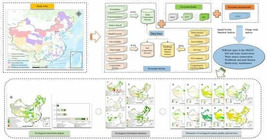
Spatiotemporal Analysis of Ecosystem Status in China’s National Key Ecological Function Zones

1
Key Laboratory of Terrestrial Surface Pattern and Simulation, Institute of Geographic Sciences and Natural Resources Research, Chinese Academy of Sciences, Beijing 100101, China
2
University of Chinese Academy of Sciences, Beijing 100049, China
3
Ecology and Nature Conservation Institute, Chinese Academy of Forestry, Beijing 100091, China
4
Academy of Agriculture and Forestry Sciences, Qinghai University, Xining 810016, China
*
Author to whom correspondence should be addressed.
Remote Sens. 2023, 15(18), 4641; https://doi.org/10.3390/rs15184641
Submission received: 4 August 2023 / Revised: 1 September 2023 / Accepted: 20 September 2023 / Published: 21 September 2023
(This article belongs to the Special Issue Monitoring Environmental Changes by Remote Sensing)

Abstract

:
The National Key Ecological Function Zones (NKEFZ) serve as crucial ecological security barriers in China, playing a vital role in enhancing ecosystem services. This study employed the theoretical framework of ecological benefits assessment in major ecological engineering projects. The primary focus was on the ecosystem macrostructure, ecosystem quality, and key ecosystem services, enabling quantitative analysis of the spatiotemporal changes in the ecosystem status of the NKEFZ from 2000 to 2019. To achieve this, remote sensing data, meteorological data, and model simulations were employed to investigate five indicators, including land use types, vegetation coverage, net primary productivity of vegetation, soil conservation services, water conservation services, and windbreak and sand fixation services. The analysis incorporated the Theil–Sen Median method to construct an evaluation system for assessing the restoration status of ecosystems, effectively integrating ecosystem quality and ecosystem services indicators. The research findings indicated that land use changes in NKEFZ were primarily characterized by the expansion of unused land and the in of grassland. The overall ecosystem quality of these zones improved, showing a stable and increasing trend. However, there were disparities in the changes related to ecosystem services. Water conservation services exhibited a decreasing trend, while soil conservation and windbreak and sand fixation services showed a steady improvement. The ecosystem of the NKEFZ, in general, displayed a stable and recovering trend. However, significant spatial heterogeneity existed, particularly in the southern region of the Qinghai–Tibet Plateau and at the border areas between western Sichuan and northern Yunnan, where some areas still experienced deteriorating ecosystem conditions. Compared to other functional zones, the trend in the ecosystem of the NKEFZ might not have been the most favorable. Nonetheless, this could be attributed to the fact that most of these areas were situated in environmentally fragile regions, and conservation measures may not have been as effective as in other functional zones. These findings highlighted the considerable challenges ahead in the construction and preservation of the NKEFZ. In future development, the NKEFZ should leverage their unique natural resources to explore distinctive ecological advantages and promote the development of eco-friendly economic industries, such as ecological industry, ecological agriculture, and eco-tourism, transitioning from being reliant on external support to self-sustainability.

Graphical Abstract

1. Introduction

Ecosystems deliver a wide range of essential services, both directly and indirectly, to fulfill human requirements. These services encompass provisioning, regulating, supporting, and cultural aspects, contributing to human survival and development [1,2,3]. Nevertheless, the interplay of climate change, continuous population growth, and unsustainable utilization of natural resources has given rise to a cascade of challenges, including heightened occurrences of extreme climatic events [4], land degradation [5], environmental pollution [6], and a notable decline in biodiversity [7]. As a consequence, ecosystem degradation has emerged as a critical global concern [8]. In response, China has undertaken a series of significant ecological engineering initiatives, such as the Three-North Afforestation Program, the Natural Forest Protection Program, and the Grain for Green Program, to safeguard and restore ecosystems [9]. Presently, the overall trajectory of ecological degradation in China has been successfully curtailed, with ecosystems progressively exhibiting signs of improvement. However, the comprehensive resilience of natural ecosystems remains precarious [10]. To optimize the spatial development framework, fortify ecological preservation, and enhance the ecological environment within key regions, the Chinese State Council introduced the “National Master Plan for Main Functional Zones” in 2010. This plan designates NKEFZ as areas characterized by vulnerable ecosystems, significant ecological functions, and limited resource and environmental carrying capacity. These zones play a pivotal role in crucial ecosystem services, including soil and water conservation, water source regulation, biodiversity maintenance, and windbreak and sand fixation, consequently exerting an influence on China’s ecological security [11,12]. Within the purview of the NKEFZ, a stringent regulatory framework governs diverse developmental activities, progressively reducing the spatial footprint occupied by human interventions and facilitating superior protection and sustainable development of the ecological environment.
Currently, there is a considerable body of research focusing on China’s NKEFZ. However, the predominant focus of these studies lies in the analysis of transfer payments [13,14] and ecological compensation standards [12,15,16], operational mechanisms, and ecological effectiveness within these zones [17,18]. Furthermore, discussions revolve around topics such as ecological assessment criteria, existing issues, as well as the vulnerability and sensitivity of these ecologically significant areas [19]. The rapid advancement of remote sensing technology and the ongoing refinement of ecosystem models have prompted an increasing number of scholars to shift their attention toward the evaluation of ecological patterns and services within the NKEFZ, adopting a large-scale and multidimensional approach. For instance, Liu et al. (2018) employed remote sensing data, geographic information system platforms, and ecological models to quantitatively analyze the spatiotemporal distribution patterns and changes in the macro-ecosystem structure and key ecosystem services within China’s NKEFZ. Their study focused on the periods before (2000–2010) and after (2010–2015) the implementation of transfer payments [20]. Similarly, Liu et al., (2020) conducted a quantitative analysis of the spatial-temporal distribution patterns and changes in ecosystem service values within the NKEFZ following the implementation of transfer payments (2010–2015) [21]. At the regional scale, Zhou et al., (2020) [22], Hou et al., (2018) [23], and Zhang et al., (2022) [24] respectively investigated the variations in ecosystem service values and levels of green development in specific areas, namely Ningxia Yanchi County, the central mountainous area of Hainan Island, and Heilongjiang Province. They also put forth policy recommendations in their respective studies. Moreover, some scholars have undertaken analyses focusing on the socio-economic conditions of the NKEFZ, as well as exploring the poverty reduction effects associated with these areas [15,25].
However, comprehensive studies at the national level that analyze the ecosystem quality and ecosystem services of different types of NKEFZ, quantify their trends of change, and compare them with non-key ecological function zones are lacking. Additionally, there is a paucity of research concerning the spatiotemporal evaluation of ecosystem quality, ecosystem services, and the degree of ecosystem restoration. Quantitatively assessing the ecological status and spatiotemporal dynamics of China’s National Key Ecological Function Zones (NKEFZ) since 2000 can significantly underpin management decisions concerning the subsequent shift-payment system for these zones and facilitate the identification of priority areas for ecological restoration efforts within the NKEFZ. To address these research gaps, this study centered on the NKEFZ and drew on an ecosystem service evaluation framework [26]. It also employed the theoretical framework of major ecological engineering and ecological benefits assessment [27]. By selecting indicators such as the ecosystem macrostructure, ecosystem quality, and key ecosystem services, and utilizing remote sensing data, meteorological data, and model simulations, the study quantitatively analyzed the spatiotemporal changes in the ecosystem macrostructure, ecosystem quality, ecosystem services, and spatial disparities in ecosystem restoration levels within the NKEFZ from 2000 to 2019. Furthermore, a comparative analysis was conducted with other non-key ecological function zones, such as major agricultural production zones (MAPZ), key development zones (KDZ), and optimized development zones (ODZ). The ultimate aim of this study is to provide scientific evidence for the ecological environment construction and management of the NKEFZ in subsequent stages.

2. Materials and Methods

2.1. Study Area

China’s NKEFZ are categorized into four distinct types: soil and water conservation (SWCA), water source conservation (WCA), windbreak and sand fixation (WAFA), and biodiversity maintenance (BMA) [28]. These zones encompass restricted development areas as well as prohibited development areas, spanning across 676 counties and cities, with a combined land area of approximately 5.06 million square kilometers. This expansive coverage constitutes 52.7% of China’s total land territory. The geographical distribution of these zones is illustrated in Figure 1. During the period from 2008 to 2019, the central government of China has consistently disbursed a cumulative total of 523.5 billion yuan as transfer payments directed toward the NKEFZ [29]. The primary objectives of these transfer payments encompass maintaining the stability of forested land areas, safeguarding the integrity of grasslands, augmenting the extent of river, lake, and wetland areas, and effectively managing spatial occupation by human activities at the prevailing level. Additionally, these endeavors strive to curtail ecological degradation, facilitate the restoration of grassland vegetation with a notable enhancement in coverage, amplify the water conservation capacity of green ecological spaces per unit area, proficiently mitigate soil erosion and desertification, and ensure the tangible preservation of biodiversity.

2.2. Methods

This study examines the degree of ecological restoration in China’s NKEFZ using a remote sensing evaluation method proposed by Shao et al., (2022) [27]. The evaluation encompasses three dimensions: ecosystem macrostructure, ecosystem quality, and ecosystem services (Figure 2). The ecosystem macrostructure is assessed by considering various land use/cover categories, such as cropland, forestland, grassland, water and wetland, build-up land, desert land, and unused land. The evaluation of ecosystem quality employs vegetation net primary productivity and vegetation cover as indicators for assessment. In terms of ecosystem services, the evaluation focuses on soil conservation services, water source conservation services, and windbreak and sand fixation services, which serve as the selected indicators for remote sensing assessment. The ecosystem quality data were based on data products, while the ecosystem service data were estimated using model simulations.

2.2.1. Ecosystem Macrostructure

The assessment of ecosystem macrostructure in this study relies on land use/land cover data and employs remote sensing classification techniques to delineate ecosystem types. To achieve this, a combination of high-resolution remote sensing, unmanned aerial vehicle (UAV), and ground survey observation techniques is utilized, leveraging China’s regional Landsat-TM/ETM satellite imagery and Landsat 8 satellite remote sensing data. Furthermore, a human–machine interactive interpretation method, grounded in geoscientific knowledge, is integrated into the analysis. This comprehensive approach enables the acquisition of 1:100,000-scale land use-type vector data, which is subsequently utilized to generate 1 km grid-based percentage ecosystem type data. Notably, the accuracy of the primary land use types surpasses 90% through rigorous field validation procedures [30,31]. As a result, five distinct sets of ecosystem type datasets for the NKEFZ are generated, covering the years 2000, 2005, 2010, 2015, and 2020.

2.2.2. Ecosystem Quality Data

(1)
Vegetation Coverage
In this study, the MODIS MOD13Q1 NDVI data product from 2000 to 2019 was employed, which provides a temporal resolution of 16 days and a spatial resolution of 250 m [32]. The computation of annual vegetation coverage was performed using the pixel binary model and the maximum synthesis method. Following the calculation, the data were further resampled to a resolution of 1 km. The specific formula used for the computation is provided as follows:
F V C = N D V I N D V I m i n N D V I m a x N D V I m i n × 100 %
where F V C is the vegetation coverage (%); N D V I m i n represents the NDVI value of pixels with no vegetation coverage, obtained as the NDVI value at the 5th percentile; N D V I m a x represents the NDVI value of pixels with complete vegetation coverage, obtained as the NDVI value at the 95th percentile.
(2)
Net primary productivity of vegetation
We employed the vegetation net primary productivity (NPP) data product, MODIS MOD17A3, with a temporal resolution of 1 year and a spatial resolution of 500 m. The unit of measurement was kg C/m2/year. This data product was classified as Level 4 and underwent atmospheric correction, radiometric correction, geometric correction, and cloud removal procedures. To validate the accuracy of the nationwide MODIS NPP data, the research team utilized 168 grassland sample data collected from Qinghai, Tibet, Ningxia, and Inner Mongolia from 2004 to 2006. Additionally, the productivity data of typical forest ecosystems in China, obtained from the long-term dynamic monitoring of forest ecosystem flux observation stations by the China Ecosystem Research Network (CERN), was also utilized. The validation process yielded an R2 value of 0.75 [33]. Subsequently, the NPP data from MODIS was resampled to generate a 1 km resolution annual vegetation net primary productivity dataset covering the years 2000 to 2019.

2.2.3. Ecosystem Services Data

(1)
Water conservation services
The estimation of water conservation in this study is carried out utilizing the water balance method and adopting the water yield calculation formula derived from the InVEST model [34]:
Q w r = P E T R
where Q w r represents the water conservation expressed in millimeters (mm). The precipitation ( P ) is obtained from observations collected at ground meteorological stations provided by the China Meteorological Administration. To obtain comprehensive precipitation data, a combination of the ANUSPLIN interpolation technique and the 0.25° × 0.25° daily precipitation grid data provided by the China Meteorological Administration is utilized. The actual evapotranspiration on the land surface (ET), measured in millimeters (mm), is sourced from the China 1 km monthly potential evapotranspiration dataset available at the National Tibetan Plateau Data Center. Moreover, the surface runoff (R) is calculated by multiplying the precipitation with the surface runoff coefficient, both measured in millimeters (mm) [26].
(2)
Soil conservation services
In this research, the soil erosion modulus was employed as a direct indicator to quantify the soil conservation service provided by the ecosystem. A reduced soil erosion modulus signified an enhanced soil conservation service, whereas an increased soil erosion modulus implied a diminished soil conservation service.
The calculation of the soil erosion modulus was carried out utilizing the Revised Universal Soil Loss Equation (RUSLE), which is a well-established method developed in the United States for assessing soil erosion. The formula for computing the soil erosion modulus was provided below [35]:
A = R × K × L × S × C × P
In the equation, various factors are considered to calculate the soil erosion modulus ( A ) expressed in units of t·hm−2·a−1. The rainfall erosivity factor ( R ), measured in MJ·mm·hm−2·h−1·a−1, is obtained from observations collected at national meteorological stations using a semi-monthly rainfall erosivity model [36]. The soil erodibility factor ( K ), measured in t·hm2·h·hm−2·MJ−1·mm−1, derived using the soil erosion productivity evaluation model (EPIC) based on the Chinese 1:1,000,000 soil dataset [37]. The slope length factor ( L ) and slope steepness factor ( S ), both dimensionless, are calculated using digital elevation model (DEM) data based on the methodology proposed by Liu et al. [38]. The cover and management factor ( C ), also dimensionless and ranging from 0 to 1, is obtained from the MODIS NDVI dataset. The conservation practice factor ( P ), also dimensionless and ranging from 0 to 1, represents the effectiveness of soil conservation measures [39].
To validate the simulated results of the soil erosion modulus, we compared them with sediment concentration monitoring data from the Jimai and Tangnaihai hydrological stations. The resulting R2 values were 0.79 and 0.57, respectively (p < 0.01).
(3)
Windbreak and sand fixation services
In this study, the soil wind erosion modulus was employed as an indicator to quantify the effectiveness of the windbreak and sand fixation service provided by the ecosystem. A decrease in the soil wind erosion modulus signifies an improvement in the windbreak and sand fixation service, whereas an increase in the soil wind erosion modulus suggests a decline in the windbreak and sand fixation service. The calculation of the soil wind erosion modulus was performed using the Revised Wind Erosion Equation (RWEQ), the formula for which are presented below [40]:
S L = Q x X
Q X = Q m a x 1 e X S 2
Q m a x = 109.8 W F × E F × S C F × K × C O G
S = 150.71 W F × E F × S C F × K × C O G 0.3711
where S L represents the soil wind erosion modulus (kg/m2), X denotes the length of the plot (m), Q X represents the sand flux at location x within the plot (kg/m), Q m a x denotes the maximum sediment transport capacity of the wind (kg/m), and S represents the critical plot length (m). Additionally, WF represents the meteorological factor (kg/m), EF represents the soil erodibility factor (dimensionless), SCF represents the soil crust factor (dimensionless), K prime denotes the soil roughness factor (dimensionless), and COG represents the comprehensive vegetation factor (dimensionless).
The soil wind erosion modulus dataset for the years 2000 to 2019, estimated using the Revised Wind Erosion Equation (RWEQ) at a resolution of 1 km, was compared with the soil wind erosion modulus determined by 137CS measurements and the predicted results from wind tunnel experiments. The coefficient of determination (R2) between these datasets was found to be 0.45 [41].

2.2.4. Ecological Restoration Situation and Degree of Ecological Restoration

The Theil–Sen Median method, a robust non-parametric statistical approach, has garnered considerable attention in the realm of trend computation. Its exceptional performance is attributed to its high computational efficiency and remarkable resilience to measurement errors and outliers, rendering it a highly suitable tool for trend analysis in long-time series data [42,43]. The formula is as follows:
β = Median X j X i j i , j > i
where β represents the trend, M e d i a n ( ) represents the median value, X j and X i are the assessment values at the same pixel location in year j and year i, respectively. If β > 0, it signifies a discernible upward trend, whereas β < 0 denotes a noticeable decreasing trend.
Using the Theil–Sen Median method, the change slope P was calculated for the periods of 2000–2010 and 2010–2019 to assess the variations in ecosystem quality (vegetation cover and net primary productivity) and ecosystem services (water source conservation, soil conservation, and windbreak and sand fixation). The values of p were evaluated as follows: p > 0.05 indicated improvement, −0.05 ≤ p ≤ 0.05 indicated basic stability, and p < −0.05 indicated deterioration (Please take note that soil erosion modulus and soil wind erosion modulus demonstrate contrasting trends). The ecological restoration situation of ecosystem quality and ecosystem services for the period of 2000–2019 was assessed based on the findings presented in Table 1.
Using the Theil–Sen Median method, the trend slopes of five indicators, namely vegetation cover, net primary productivity, soil erosion modulus, soil wind erosion modulus, and water source conservation, were calculated for the period from 2000 to 2019. Based on the classification criteria for positive transitions, negative transitions, and basic stability, spatial distribution data were obtained for the three categories of positive transitions, negative transitions, and basic stability for the five key ecological functional zones during the same time period.
By performing spatial overlay analysis on the three categories of distribution data for the five indicators, as presented in Table 2, the spatial distribution of the ecological system recovery level in the NKEFZ from 2000 to 2019 was determined.

3. Results

3.1. Status of Ecosystem Macrostructure Changes in NKEFZ

Based on Figure 3, it can be observed that ecosystem macrostructure in the NKEFZ of the country are primarily composed of grassland, followed by forestland and desert land. Among the different types of key ecological functional areas, water source conservation areas were mainly dominated by forestland and grassland, followed by cropland and desert land. Soil and water conservation areas were mainly dominated by forestland, followed by cropland and grassland. Biodiversity maintenance areas were mainly composed of grassland, followed by forestland. Windbreak and sand fixation areas were mainly dominated by grassland and desert, followed by unused land.
From 2000 to 2020, the ecosystem macrostructure in the NKEFZ were mainly characterized by the expansion of unused land and the reduction of grassland. Unused land expanded by 101,000 km2, mainly resulting from the conversion of grassland and desert land (Figure 3a), concentrated in the desert area of the northwestern Qiangtang Plateau in Tibet. Grassland decreased by 228,000 km2, primarily transformed into unused land, followed by desert land and forestland, with the conversion to unused land mainly concentrated in the desert area of the northwestern Qiangtang Plateau in Tibet and the southeastern part of Xinjiang. The regions converted to desert are mainly distributed in the desert area of the northwestern Qiangtang Plateau in Tibet, the northern Tarim Basin in Xinjiang, and the surrounding areas of the Qaidam Basin in Qinghai. The regions converted to forestland are relatively scattered, mainly in the western part of Sichuan, the southern part of Shaanxi, and the border area between Inner Mongolia and Heilongjiang.
In soil and water conservation-type areas, the main changes observed were the reduction of cropland and the increase in build-up land. The reduction of cropland primarily transformed into grassland and forestland, while the increase in build-up land mainly resulted from cropland (Figure 3b). In water source conservation-type areas, the main changes observed were the increase in water and wetland, as well as the decrease in desert land. The increase in water and wetland mainly resulted from the conversion of forestland and grassland, while the decrease in desert land mainly transformed into grassland and unused land (Figure 3c). Biodiversity maintenance-type areas primarily experienced a reduction in grassland and an increase in unused land. The reduction in grassland mainly transformed into unused land and desert land, while the increase in unused land mainly resulted from grassland and desert land (Figure 3d). Windbreak and sand fixation-type areas mainly witnessed an increase in desert land and a reduction in unused land. The increase in desert land mainly resulted from grassland and unused land, while the reduction in unused land primarily transformed into grassland (Figure 3e).

3.2. Dynamics of Ecological System Quality in NKEFZ

3.2.1. Vegetation Coverage

The average annual rate of vegetation coverage change in the NKEFZ from 2000 to 2019 was 0.08%/a, showing an overall stable increasing trend. Regions with notable increases were concentrated in the loess hilly-gully soil conservation area, the Hunshandake desertification control area, and the Horqin grassland area. Regions with significant decreases were primarily found in the western part of the Junggar Basin, certain areas of the Qinghai–Tibet Plateau, and the northern part of the Hunshandake desertification control area (Figure 4a). Among them, the soil and water conservation type exhibited the highest annual growth rate of vegetation coverage at 0.55%/a, while the biodiversity conservation type showed the lowest rate at 0.04%/a (Figure 4b).
From 2010 to 2019, the average annual vegetation coverage in the NKEFZ increased by 0.87% compared to the period of 2000–2010. The spatial distribution trend of this increase exhibited a remarkable alignment with the corresponding changes in vegetation coverage rates. Regions with notable increases were mainly concentrated in the loess hilly-gully soil conservation area, while regions with decreases were concentrated in the western part of the Junggar Basin and certain areas of the Qinghai–Tibet Plateau (Figure 4c). Among them, the soil and water conservation type exhibited the largest increase in vegetation coverage at 5.23%, while the water source conservation type showed the smallest increase at 0.41% (Figure 4d).

3.2.2. Net Primary Productivity (NPP) of Vegetation

The average annual change rate of NPP in NKEFZ from 2000 to 2019 was 1.98 gC/m2/a, showing an overall increasing trend. Regions with significant increases were concentrated in the central and northeastern areas of the key ecological functional zones, primarily distributed in the hilly and gully regions of the Loess Plateau, the Hunshandake Desertification Control Zone, the Horqin Grassland, the Da Hinggan Mountains Forest Area, the Qinling-Bashan Biodiversity Zone, and the Three Gorges Reservoir Area for soil and water conservation. Regions with significant decreases were mainly distributed in the southwestern area of the forested region along the southeastern edge of the Tibetan Plateau and the Karst Rocky Desertification Control Zone of Guizhou, Guangxi, and Yunnan (Figure 5a). Among different types of NKEFZ, the soil and water conservation type showed the highest average annual growth rate of NPP, at 6.47 gC/m2/a, while the biodiversity maintenance type had the lowest growth rate, at 0.94 gC/m2/a (Figure 5b).
From 2010 to 2019, the average annual NPP in NKEFZ increased by 18.83 gC/m2 compared to the period from 2000 to 2010. The spatial distribution pattern was generally consistent with the spatial distribution of the average annual change rate of NPP, exhibiting a high value in the central and northeastern regions, a lower value in the southwestern border, and the lowest value in the northwest (Figure 5c). Among different types of NKEFZ, the soil and water conservation type showed the highest increase in NPP, reaching 61.5 gC/m2, while the biodiversity maintenance type showed the lowest increase, at 6.18 gC/m2 (Figure 5d).

3.3. Dynamics of Ecosystem Services in NKEFZ

3.3.1. Water Conservation Services

During the period from 2000 to 2019, the NKEFZ witnessed a steady decline in the annual average rate of water conservation quantity, with a negative value of −0.16 thousand m3/km2/a. This trend indicates an overall decrease in water source conservation within the studied zones. Analysis of Figure 6a reveals noticeable increases in water conservation in specific regions, namely the Three-River Headwaters Region grassland meadow area, the Gan River’s crucial water source replenishment area in southern China, the Zoige grassland wetland area, and the Dabie Mountains soil and water conservation area. Conversely, peripheral regions of the Southeast Tibetan Plateau forest area demonstrate significant reductions in water conservation.
Among the different types of NKEFZ, the water source conservation type exhibited the highest annual average growth rate of 0.2 thousand m3/km2/a. Conversely, the soil and water conservation, windbreak and sand fixation, and biodiversity maintenance types exhibited declining trends. Of particular note was the biodiversity maintenance type, which experienced the most rapid annual average decline rate of −2.1 thousand m3/km2/a, as illustrated in Figure 6b.
Additionally, a comparison of the average water conservation quantity from 2010 to 2019 with that of 2000 to 2010 in the NKEFZ revealed an increase of 2.2 thousand m3/km2. The spatial distribution pattern of water conservation changes aligned closely with the spatial distribution of change rates, characterized by concentrated areas of both high and low values (Figure 6c). Furthermore, variations in the increase or decrease in water conservation quantity were evident among the different types of NKEFZ. Specifically, the soil and water conservation and biodiversity maintenance types demonstrated decreasing trends, while the water source conservation and windbreak and sand fixation types exhibited increasing trends. Notably, the water source conservation type exhibited the highest increase, with a substantial increment of 11.6 thousand m3/km2. Conversely, the soil and water conservation type indicated a decrease, declining by 9.4 thousand m3/km2, as illustrated in Figure 6d.

3.3.2. Soil Conservation Services

From 2000 to 2019, the soil erosion modulus within the NKEFZ experienced an average annual change rate of −0.14 t/ha/a, indicating a prevalent trend of decline. Notably, specific regions within the southern and central parts of the zones exhibited a substantial reduction in soil erosion modulus, while peripheral areas in the northwest, particularly around the Tarim Basin, demonstrated a noticeable upward trend (Figure 7a). Among the various types of NKEFZ, the windbreak and sand fixation type was the sole exception, as it experienced growth in soil erosion modulus. Conversely, the remaining types showcased a decreasing trend in the change rates of soil erosion modulus. The windbreak and sand fixation type exhibited the highest annual average growth rate of 0.11 t/ha/a, while the soil and water conservation type experienced the most rapid annual average decline rate of −0.79 t/ha/a (Figure 7b).
Furthermore, when comparing the average soil erosion modulus between 2010 and 2019 with that of 2000 to 2010 within the NKEFZ, a decrease of 2.78 t/ha was observed. The spatial distribution pattern of soil erosion modulus changes, as depicted in Figure 7c, closely adhered to the Hu Huanyong Line, demonstrating a decreasing trend in the southeast and an increasing trend in the northwest. Consistent with the change rates, with the exception of the windbreak and sand fixation type, the other types exhibited a decreasing trend in the changes in soil erosion modulus (Figure 7d).

3.3.3. Windbreak and Sand Fixation Services

The average annual rate of change in soil wind erosion modulus within the NKEFZ from 2000 to 2019 was −1.14 t/ha. The regions with the most substantial reduction in soil wind erosion modulus were primarily distributed in the northeastern part of the Badain Jaran Desert, the Taklimakan Desert, and certain areas of the Tianshan Mountains. Conversely, regions with significant increases were predominantly found in the northern part of the Junggar Basin and certain areas of the Hulunbuir Plateau (Figure 8a). Distinct variations in soil wind erosion modulus were observed among different types of NKEFZ, with the water conservation type experiencing the highest decrease, at 2.85 t/ha, while the soil and water conservation type exhibited the smallest reduction, at 0.10 t/ha (Figure 8b).
In the NKEFZ, the average annual soil wind erosion modulus decreased by 10.25 t/ha from 2010 to 2019 compared to the period from 2000 to 2010. The spatial distribution trend of soil wind erosion modulus changes corresponded to the change rates, except for an increase in soil wind erosion modulus in the northern part of the Hunshandake Sandy Land (Figure 8c). Among different types of NKEFZ, the windbreak and sand fixation type showed the largest reduction in soil wind erosion modulus, at 16.90 t/ha, while the water source conservation type displayed the smallest decrease, at 0.35 t/ha (Figure 8d).

3.4. Ecological Restoration Situation of NKEFZ

3.4.1. Ecosystem Quality Restoration Trend

The restoration trend of vegetation coverage within the NKEFZ from 2000 to 2019 was primarily characterized by maintaining stability, accounting for 45.08% of the total area. This trend was mainly observed in regions such as Xinjiang, Tibet, Inner Mongolia, and certain areas of Heilongjiang. The continuously improving areas accounted for 8.24% and were predominantly concentrated in the hilly and gully conservation areas of the Loess Plateau. The continuously worsening areas accounted for 4.09% and were primarily distributed in the Hunshandake Desert control zone and its surrounding regions (Figure 9a). Among different types of NKEFZ, the soil and water conservation type exhibited a predominant trend of continuous improvement, covering an area of 35.96%, while the area with a continuous worsening trend accounted for 0.93%. The water source conservation type showed a predominant trend of maintaining stability, with areas of continuous improvement accounting for 8.01% and areas of continuous worsening accounting for 3.77%. The windbreak and sand fixation type exhibited a predominant trend of maintaining stability, with areas of continuous improvement accounting for 4.52% and areas of continuous worsening accounting for 3.64%. The biodiversity maintenance type of vegetation coverage mainly exhibited a trend of maintaining stability, with areas of continuous improvement accounting for 6.13% and areas of continuous worsening accounting for 5.48% (Figure 9b).
The restoration trend of net primary productivity (NPP) of vegetation from 2000 to 2019 was primarily characterized by maintaining stability and continuous improvement, accounting for 43.46% and 26.68% of the total area, respectively. Regions with stable NPP were concentrated in the Qinghai–Tibet Plateau, Badain Jaran Desert, and its northern regions. Regions with continuous improvement were concentrated near the Hu Huanyong Line. The areas with a continuous worsening trend accounted for only 1.17% and were dispersed in the forested areas on the edge of the Southeast Tibetan Plateau, Nanling Mountains, and biodiversity regions (Figure 9c). The soil and water conservation type primarily exhibited a trend of continuous improvement, covering 70.75% of the total area, while the area with a continuous worsening trend accounted for 1.13%. The water source conservation type of NPP predominantly showed a trend of continuous improvement and maintaining stability, covering areas of 35.72% and 25.96%, respectively, with the area of continuous worsening accounting for 1.46%. The windbreak and sand fixation type exhibited a trend of maintaining stability and continuous improvement, with areas accounting for 67.53% and 14.88%, respectively, while the area with a continuous worsening trend accounted for only 0.26%. The biodiversity maintenance type of NPP mainly exhibited a trend of maintaining stability, continuous improvement, and initial improvement followed by stability, covering areas of 46.84%, 19.80%, and 11.86%, respectively, while the area with a continuous worsening trend accounted for 1.74% (Figure 9d).

3.4.2. Ecosystem Services Restoration Trend

The restoration trend of water conservation in the NKEFZ from 2000 to 2019 was mainly characterized by maintaining stability and continuously worsening, accounting for 20.04% and 18.97% of the total area, respectively. The regions with maintained stability were primarily distributed in the windbreak and sand fixation ecological functional zones, concentrated in the northern part of the Qinghai–Tibet Plateau and the central-northern part of the Inner Mongolia Plateau. The areas with continuous worsening were mainly distributed in the Huai River Basin and the northwest border region. The regions with continuously improving were mainly found in the Three-River Headwaters Region grassland meadow wetland area, covering 8.63% of the total area (Figure 10a). Among different types of key ecological function zones, the restoration trend of soil and water conservation was mainly characterized by a transition from deterioration to improvement and continuously worsening, with Continuous worsening covering 21.76% of the area and continuously improving covering 5.27%. The restoration trend of water conservation was primarily characterized by a transition from improvement to deterioration and a transition from improvement to stability, with continuously improving covering 12.08% of the area and worsening covering 16.03%. The restoration trend of windbreak and sand fixation water conservation mainly featured maintaining stability, with continuously improving covering 4.86% of the area and worsening covering 5.25%. The restoration trend of biodiversity maintenance water conservation was mainly characterized by continuously worsening and maintaining stability, with continuously improving covering 8.36% of the area and worsening covering 29.55% (Figure 10b).
The restoration trend in the NKEFZ during the two periods was primarily dominated by maintaining stability, extensively distributed in the northern and western parts of the zones, while the changing areas were mainly concentrated in the southern regions, roughly divided by the Hu Line, accounting for 86.55% of the total area. The areas with continuously improving soil erosion modulus accounted for 0.96% and were mainly distributed in the soil and water conservation areas of the Loess Plateau and some regions in the forested areas of southeastern Tibet. The regions with continuous worsening were relatively few and scattered, occupying only 0.47% of the total area (Figure 10c). Among different types of key ecological function zones, maintaining stability was the primary restoration trend for all four types. For the soil and water conservation type, the area with continuously improving accounted for 2.66%, and the area with continuous worsening accounted for 0.61%. For the water source conservation type, the area with continuously improving accounted for 0.39%, and the area with continuous worsening accounted for 0.32%. The windbreak and sand fixation type had relatively small areas of continuously improving and continuously worsening, accounting for only 0.33% and 0.11% of the total area, respectively. The biodiversity maintenance type had continuously improved covering 1.84% of the area and continuously worsened covering 1.03% (Figure 10d).
The restoration trend of soil erosion modulus in the NKEFZ during the two periods was mainly characterized by maintaining stability and continuously improving. The regions with maintained stability were mainly distributed in the Three-River Headwaters Region grassland meadow wetland area, the important Yellow River source replenishment area in Gannan, the Qilian Mountains glacier and water conservation area, the Loess Plateau soil and water conservation area, the Greater and Lesser Khingan Mountains forested area, the Horqin grassland area, and parts of the western and northern regions of Xinjiang, covering 59.58% of the total area. The areas with continuously improving accounted for 11.53% and were concentrated in the Taklamakan Desert region of the Tarim Basin, the western part of the Qinghai–Tibet Plateau, and the northern region of the Badain Jaran Desert (Figure 10e). Among different types of key ecological function zones, maintaining stability was the main restoration trend for the soil erosion modulus of the soil and water conservation type, covering 98.11% of the area, followed by a transition from improvement to stability, covering 1.74% of the area. For the water source conservation type, maintaining stability accounted for 84.41% of the area, followed by a transition from stability to improvement, covering 4.69% of the area. The windbreak and sand fixation type exhibited maintained stability as the main restoration trend, followed by continuously improving and a transition from improvement to deterioration. The biodiversity maintenance type showed maintained stability as the main restoration trend, covering 54.84% of the area, followed by continuously improving and a transition from improvement to stability (Figure 10f).

3.5. Spatial Distribution of Ecological Restoration Degree in NKEFZ

From 2000 to 2019, the NKEFZ demonstrated an overall trend of stability and recovery in the ecosystems, albeit with localized areas experiencing ecological deterioration. The predominant segment, encompassing 41.12% of the total area, exhibited an essentially stable level of ecological restoration, mainly concentrated in the windbreak and sand fixation functional zones within the Alashan grassland desertification control area, the Badain Jaran Desert, and its northern region. Regions exhibiting significant recovery were scattered across diverse areas, including the Loess Plateau hilly and gully soil and water conservation area, the Three Gorges reservoir soil and water conservation area, the Wuling Mountain biodiversity and soil and water conservation area, the Guizhou-Yunnan-Guangxi-Karst rocky desertification control area, the Qinba biodiversity area, the Horqin grassland area, the Hunshandake Sandy Land area, and certain localized regions within the Greater and Lesser Khingan Mountains forest area. Areas characterized by partial elements improved while others worsened degree and the moderate level of improved degree of ecosystem accounted for 19.61% and 19.60%, respectively, with a widespread distribution across the NKEFZ. Conversely, areas experiencing significantly worsened were minimal, comprising only 0.04% of the total area, primarily observed in the biodiversity conservation area and scattered across the southern region of the Qinghai–Tibet Plateau, the western edge of Sichuan, and the northern border region of Yunnan (Figure 11a). Among the various types of key ecological functional zones, the soil and water conservation functional zones primarily focused on ecosystem restoration, with the largest area characterized by a relatively high level of improvement, accounting for 35.52% of the total area, followed by areas with a moderate level of improved, accounting for 28.09%. The water conservation functional zones predominantly aimed for stability and restoration, with the largest area exhibiting a moderate level of improved level, followed by an essentially stable level, accounting for 30.27% and 28.53% of the total area, respectively. The windbreak and sand fixation functional zones mainly emphasized essentially stability, covering 66.70% of the total area, with additional areas exhibiting moderate levels of improvement. The biodiversity conservation functional zones primarily encompassed regions with an essentially stable level, alongside areas demonstrating partial elements improved while others worsened level (Figure 11b).

4. Discussion

From 2000 to 2019, discernible disparities in ecosystem quality and ecosystem services were evident among diverse functional zones, encompassing the NKEFZ, major agricultural production zones, key development zones, and optimized development zones. Regarding vegetation cover dynamics, the major agricultural production zones exhibited the highest annual average growth rate at 0.2%, while the optimized development zones demonstrated a declining trend with an annual average reduction of 0.17% (Figure 12a). As for changes in net primary productivity of vegetation, the key development zones displayed the highest annual average growth rate at 3.94 gC/m2/a, whereas the NKEFZ had the lowest growth rate at 1.97 gC/m2/a (Figure 12b). In terms of water conservation services, both major agricultural production zones, and optimized development zones exhibited an increasing trend, with both at 0.06 thousand m3/km2/year. Conversely, the key development zones experienced the swiftest annual average decline rate in soil erosion modulus at −1.05 thousand m3/km2/a (Figure 12c). Turning to soil conservation services, the optimized development zones demonstrated the highest annual average growth rate of soil conservation capacity at 1.56 t/hm2/a, whereas the NKEFZ had the lowest growth rate of soil erosion modulus at 0.41 t/hm2/a (Figure 12d). Concerning windbreak and sand fixation services, the NKEFZ exhibited the most pronounced rate of change in soil wind erosion modulus at −1.14 t/hm2/a, while the optimized development zones showed the lowest rate at −0.08 t/hm2/a (Figure 12e). Concerning ecological restoration levels, the major agricultural production zones were mainly characterized by an essentially stable state, followed by a moderate level of improvement, with the smallest proportion showing significant worsened. Conversely, the key development zones were primarily associated with a moderate level of improvement, followed by partial elements improved while others worsened level, along with a relatively high level of improvement. As for the optimized development zones, they were predominantly marked by partial elements improved while others worsened level, followed by an essentially stable level and slightly worsened level (Figure 12f). Considering the holistic aspects of ecosystem quality, ecosystem services, and ecological restoration levels, it becomes evident that while the trend in NKEFZ may not be the most favorable, this observation aligns with the fact that these regions are mostly situated in environmentally fragile areas. Consequently, the effectiveness of conservation measures may not be as conspicuous as in other functional zones. This underscores the considerable challenges ahead in the establishment and preservation of the NKEFZ.
Since 2010, China has commenced the implementation of transfer payments for the NKEFZ, earmarking substantial annual funds to safeguard the ecosystem environment and enhance the quality and services of these vital regions. Overall, protracted conservation and development endeavors have yielded discernible improvements in the ecological system quality and ecosystem services of the NKEFZ, leading to a stable and recovering ecological trend. Both vegetation cover and net primary productivity have exhibited a consistent upward trajectory. Nonetheless, there are subtle variations in the dynamics of ecosystem services. Water conservation capacity has shown a declining trend, possibly attributed to the enhanced vegetation resulting in increased water consumption [44] or the underlying mechanisms employed in calculating water conservation services through water balance methodologies [45]. In parallel, soil erosion modulus and soil wind erosion modulus have both experienced a decreasing trend, signifying a sustained enhancement in soil conservation and windbreak and sand fixation services, thus underscoring the efficacy of ecological protection measures. In forthcoming ecological engineering and conservation endeavors, regions witnessing a decline in ecological restoration levels, notably the southern zone of the Qinghai–Tibet Plateau and the intersecting border areas between western Sichuan and northern Yunnan, demand bespoke, scientifically grounded strategies for protection and restoration, with a concerted focus on minimizing anthropogenic activities. While continuing to provide crucial support to the NKEFZ akin to a “blood transfusion”, it becomes imperative to leverage their unique natural resources to explore distinctive ecological resource advantages and foster the development of eco-friendly economic sectors, such as ecological industry, ecological agriculture, and eco-tourism, with the ultimate goal of transitioning towards a “self-sustaining” model. Certainly, the effective management of National Key Ecological Function Zones by government officials necessitates a multidisciplinary approach that incorporates the realms of ecology, economics, and policy [46]. This holistic assessment should encompass an examination of both advantageous and adverse outcomes [47]. It is imperative to refine control and incentive mechanisms, with a particular focus on discerning the extent to which alterations in vegetation and ecosystem conditions can be attributed to policy interventions, economic progress, and various anthropogenic activities [48]. Furthermore, stringent measures should be instituted to combat actions that contravene environmental legislation explicitly designed to protect human welfare, natural assets, and ecological systems [49].
In the evaluation of ecological benefits deriving from substantial ecological engineering undertakings, the precision of assessment outcomes assumes a pivotal role in delineating the credibility and pragmatic utility of the appraisal. Yet, due to the intricate and heterogeneous nature inherent to appraising ecological benefits within the realm of ecological engineering, the precision of these evaluative consequences frequently encounters multifarious influences. These influences encompass, inter alia, the quality of amassed data, the selection of assessment methodologies, and the inherent dynamism characterizing ecosystems. Thus, within the purview of this study’s assessment of China’s National Key Ecological Function Zones, a primary undertaking involved ensuring the meticulous accuracy and exhaustive inclusiveness of the collected data. To effectuate this, the validation of data and the implementation of stringent quality control measures were undertaken, both serving to establish the scientific integrity and rationality intrinsic to the evaluative outcomes. The present investigation, oriented towards the evaluation of the ecological status and the degrees of restitution within pivotal ecological function zones, affords an illustrative exemplar that augments the theoretical framework underpinning evaluations of ecological benefits within the context of sizable ecological engineering endeavors. Nonetheless, it is requisite to acknowledge that this study’s ambit is circumscribed by its macroscopic vantage point, underpinned by an amalgamation of remote sensing data, meteorological inputs, and model-based simulations. Thus, inherent limitations are acknowledged. Moving forward, forthcoming studies ought to adopt an encompassing perspective, one that converges divergent viewpoints, including the amalgamation of rural subsistence, the orchestration of transfer payment mechanisms, the evaluation of verdant developmental performance, and other holistic considerations, thereby fostering a comprehensive inquiry of heightened scope.

5. Conclusions

This study examined the changes in ecosystems within China’s NKEFZ between 2000 and 2019. It utilized meteorological and remote sensing data, along with modeling, to analyze ecosystem structure, quality, and services. The analysis used an ecological evaluation framework often used for large ecological projects, allowing for a quantitative assessment of restoration levels across different areas. The main study findings include:
The NKEFZ underwent significant changes, including expanding unused land and shrinking grasslands. In soil and water conservation zones, cultivated land decreased, but construction land increased. Water conservation zones saw more water bodies and wetlands, but less desert areas. Biodiversity maintenance zones had fewer grasslands, and more unused land, while windbreak and sand fixation zones had more desert areas and less unused land. The ecosystem quality showed a positive trend, indicating stability and improvement. In all functional zones, vegetation cover and primary productivity consistently increased. Water conservation services generally decreased, but water conservation zones slightly increased. On the other hand, soil conservation and windbreak/sand fixation services steadily improved.
The NKEFZ’s ecosystem remained stable and exhibited signs of recovery, but with noticeable variations. Some regions, especially in the southern part of the Qinghai–Tibet Plateau and along the border between western Sichuan and northern Yunnan, showed ecosystem deterioration. To address this, it is advisable for future ecological restoration projects to adopt location-specific and scientifically guided strategies to reduce human impacts in these vulnerable areas.

Author Contributions

Conceptualization, X.Z. and Q.S.; data curation, X.Z., M.C., B.W., X.N. and T.Z.; formal analysis, X.Z. and J.N.; investigation, X.Z. and Q.S.; methodology, X.Z. and Q.S.; software, G.L. and H.H.; supervision, Q.S.; validation, S.L.; visualization, L.N.; writing—original draft, X.Z.; writing—review and editing, X.Z., B.W., X.N. and J.N. All authors have read and agreed to the published version of the manuscript.

Funding

This research was funded by the Strategic Priority Research Program of the Chinese Academy of Sciences (Grant No. XDA23100203).

Data Availability Statement

The data that support the findings of this study are available from the corresponding author upon reasonable request.

Conflicts of Interest

The authors declare no conflict of interest.

References

  1. Costanza, R.; d’Arge, R.; de Groot, R.; Farber, S.; Grasso, M.; Hannon, B.; Limburg, K.; Naeem, S.; Oneill, R.V.; Paruelo, J.; et al. The value of the world’s ecosystem services and natural capital. Nature 1997, 387, 253–260. [Google Scholar] [CrossRef]
  2. Chen, J.; Jiang, B.; Bai, Y.; Xu, X.; Alatalo, J.M. Quantifying ecosystem services supply and demand shortfalls and mismatches for management optimisation. Sci. Total Environ. 2019, 650, 1426–1439. [Google Scholar] [CrossRef] [PubMed]
  3. Shi, Y.; Shi, D.; Zhou, L.; Fang, R. Identification of ecosystem services supply and demand areas and simulation of ecosystem service flows in Shanghai. Ecol. Indic. 2020, 115, 106418. [Google Scholar] [CrossRef]
  4. AghaKouchak, A.; Chiang, F.; Huning, L.S.; Love, C.A.; Mallakpour, I.; Mazdiyasni, O.; Moftakhari, H.; Papalexiou, S.M.; Ragno, E.; Sadegh, M. Climate Extremes and Compound Hazards in a Warming World. Annu. Rev. Earth Planet. Sci. 2020, 48, 519–548. [Google Scholar] [CrossRef]
  5. Zhang, Z.M.; Huang, X.F.; Zhou, Y.C. Factors influencing the evolution of human-driven rocky desertification in karst areas. Land Degrad. Dev. 2021, 32, 817–829. [Google Scholar] [CrossRef]
  6. Liang, W.; Yang, M. Urbanization, economic growth and environmental pollution: Evidence from China. Sustain. Comput. Inform. Syst. 2019, 21, 1–9. [Google Scholar] [CrossRef]
  7. Ceballos, G.; Ehrlich, P.R.; Barnosky, A.D.; Garcia, A.; Pringle, R.M.; Palmer, T.M. Accelerated modern human-induced species losses: Entering the sixth mass extinction. Sci. Adv. 2015, 1, 1400253. [Google Scholar] [CrossRef]
  8. Kotiaho, J.S.; Halme, P.; Kareksela, S.; Olden, A.; Haapalehto, T.; Paivinen, J.; Moilanen, A. Target for ecosystem repair is impractical. Nature 2015, 519, 33. [Google Scholar] [CrossRef]
  9. Shao, Q.; Fan, J.; Liu, J.; Yang, F.; Liu, H.; Yang, X.; Xu, M.; Hou, P.; Guo, X.; Huang, L.; et al. Approaches for Monitoring and Assessment of Ecological Benefits of National Key Ecological Projects. Adv. Earth Sci. 2017, 32, 1174–1182. [Google Scholar]
  10. Yu, G.-R.; Wang, Y.-S.; Yang, M. Discussion on the ecological theory and technological approaches of ecosystem quality improvement and stability enhancement. J. Appl. Ecol. 2023, 34, 1–10. [Google Scholar] [CrossRef]
  11. Yu, Y.; Wu, J. Research on the Conservation and Development of National Key Ecological Function Areas. Environ. Sci. Technol. 2021, 44, 219–229. [Google Scholar]
  12. Liu, G.; Wen, Y.; Jin, T.; Hao, H.; Liu, S. Designing of Watershed Ecological Compensation Mechanism Based on the Key Ecological Function Zone: A Case Study in the Source Area of Dongjiang River. Adv. Mater. Res. 2013, 807, 962–975. [Google Scholar] [CrossRef]
  13. Chen, S.; Hou, M.Y.; Wang, X.Y.; Yao, S.B. Transfer payment in national key ecological functional areas and economic development: Evidence from a quasi-natural experiment in China. Environ. Dev. Sustain. 2023. [Google Scholar] [CrossRef]
  14. Zhao, W.; Liu, H.; Xiao, Y.; Sun, C.; Luan, Z. Synergic relationship between transfer payment to national key ecological function areas and eco-environmental protection. Acta Ecol. Sin. 2019, 39, 9271–9280. [Google Scholar]
  15. Qin, B.; Yu, Y.; Ge, L.; Yang, L.; Guo, Y. Does Eco-Compensation Alleviate Rural Poverty? New Evidence from National Key Ecological Function Areas in China. Int. J. Environ. Res. Public Health 2022, 19, 10899. [Google Scholar] [CrossRef] [PubMed]
  16. Liu, S.; Zhang, J.; Zhang, J.; Li, Z.; Geng, Y.; Guo, Y. Assessing Controversial Desertification Prevention Policies in Ecologically Fragile and Deeply Impoverished Areas: A Case Study of Marginal Parts of the Taklimakan Desert, China. Land 2021, 10, 641. [Google Scholar] [CrossRef]
  17. Chen, H.; Hou, M.; Xi, Z.; Zhang, X.; Yao, S. Co-benefits of the National Key Ecological Function Areas in China for carbon sequestration and environmental quality. Front. Ecol. Evol. 2023, 11, 1093135. [Google Scholar] [CrossRef]
  18. Zhang, R.-b.; Zhong, C.-b. The establishment of the national key ecological functional zone and the county’s ecological green development. Front. Ecol. Evol. 2023, 11, 1144245. [Google Scholar] [CrossRef]
  19. Pan, F.J.; Song, M.J.; Wan, Q.; Yuan, L.L. A conservation planning framework for China’s national key ecological function area based on ecological risk assessment. Environ. Monit. Assess. 2022, 194, 74. [Google Scholar] [CrossRef]
  20. Liu, L.; Cao, W.; Wu, D.; Huang, L. Temporal and Spatial Variations of Ecosystem Services in National Key Ecological Function Zones. Sci. Geogr. Sin. 2018, 38, 1508–1515. [Google Scholar]
  21. Liu, H.; Gao, J.; Liu, X.; Zhang, H.; Xu, X. Monitoring and assessment of the ecosystem services value in the national key ecological function zones. Acta Ecol. Sin. 2020, 40, 1865–1876. [Google Scholar]
  22. Zhou, S.; Sun, P.; Zhao, K.; Wang, F.; Zuo, X. Implementation effects of the grazing withdrawal project in national key ecological function zones: A case study of Yanchi County in Ningxia Hui Autonomous Region. Pratacultural Sci. 2020, 37, 201–212. [Google Scholar]
  23. Hou, P.; Zhai, J.; Cao, W.; Yang, M.; Cai, M.; Li, J. Evaluation on ecosystem changes and protection of the national key ecological function zones in mountainous areas of central Hainan Island. Acta Geogr. Sin. 2018, 73, 429–441. [Google Scholar]
  24. Zhang, Y.; Wu, X. Urban green development level and spatio-temporal difference of cities in the National Key Ecological Function Zones and adjacent non-ecological function zones. Acta Ecol. Sin. 2022, 42, 5761–5777. [Google Scholar]
  25. Liu, S.; Zhang, J.; Zhang, J.; Guo, Y. Simultaneously tackling ecological degradation and poverty challenges: Evidence from desertified areas in northern China. Sci. Total Environ. 2022, 815, 152927. [Google Scholar] [CrossRef]
  26. Ouyang, Z.; Zheng, H.; Xiao, Y.; Polasky, S.; Liu, J.; Xu, W.; Wang, Q.; Zhang, L.; Xiao, Y.; Rao, E.; et al. Improvements in ecosystem services from investments in natural capital. Science 2016, 352, 1455–1459. [Google Scholar] [CrossRef]
  27. Shao, Q.; Liu, S.; Ning, J.; Liu, G.; Yang, F.; Zhang, X.; Niu, L.; Huang, H.; Fan, J.; Liu, J. Assessment of ecological benefits of key national ecological projects in China in 2000–2019 using remote sensing. Acta Geogr. Sin. 2022, 77, 2133–2153. [Google Scholar]
  28. Xu, J.; Liu, H.; Nie, P.; Jin, Z.; Zhai, D.; Gao, X. Spatiotemporal analysis of environmental air quality in counties of national key ecological function areas. Acta Ecol. Sin. 2022, 42, 4362–4368. [Google Scholar]
  29. Chen, C.; Li, W.-B.; Zheng, L.; Guan, C. Exploring the impacts of spatial regulation on environmentally sustainable development: A new perspective of quasi-experimental evaluation based on the National Key Ecological Function Zones in China. Sustain. Dev. 2023. early view. [Google Scholar] [CrossRef]
  30. Ning, J.; Liu, J.; Kuang, W.; Xu, X.; Zhang, S.; Yan, C.; Li, R.; Wu, S.; Hu, Y.; Du, G.; et al. Spatiotemporal patterns and characteristics of land-use change in China during 2010-2015. J. Geogr. Sci. 2018, 28, 547–562. [Google Scholar] [CrossRef]
  31. Kuang, W.; Zhang, S.; Du, G.; Yan, C.; Wu, S.; Li, R.; Lu, D.; Pan, T.; Ning, J.; Guo, C.; et al. Remotely sensed mapping and analysis of spatio-temporal patterns of land use change across China in 2015–2020. Acta Geogr. Sin. 2022, 77, 1056–1071. [Google Scholar]
  32. Bai, Y. Analysis of vegetation dynamics in the Qinling-Daba Mountains region from MODIS time series data. Ecol. Indic. 2021, 129, 108029. [Google Scholar] [CrossRef]
  33. Liu, G.; Shao, Q.; Fan, J.; Ning, J.; Rong, K.; Huang, H.; Liu, S.; Zhang, X.; Niu, L.; Liu, J. Change Trend and Restoration Potential of Vegetation Net Primary Productivity in China over the Past 20 Years. Remote Sens. 2022, 14, 1634. [Google Scholar] [CrossRef]
  34. Hamel, P.; Valencia, J.; Schmitt, R.; Shrestha, M.; Piman, T.; Sharp, R.P.; Francesconi, W.; Guswa, A.J. Modeling seasonal water yield for landscape management: Applications in Peru and Myanmar. J. Environ. Manag. 2020, 270, 110792. [Google Scholar] [CrossRef] [PubMed]
  35. Peng, S.; Ding, Y.; Liu, W.; Li, Z. 1 km monthly temperature and precipitation dataset for China from 1901 to 2017. Earth Syst. Sci. Data 2019, 11, 1931–1946. [Google Scholar] [CrossRef]
  36. Sun, W.; Shao, Q.; Liu, J. Assessment of Soil Conservation Function of the Ecosystem Services on the Loess Plateau. J. Nat. Resour. 2014, 29, 365–376. [Google Scholar]
  37. Yang, Y.Y.; Zhao, R.Y.; Shi, Z.; Rossel, R.A.V.; Wan, D.; Liang, Z.Z. Integrating multi-source data to improve water erosion mapping in Tibet, China. Catena 2018, 169, 31–45. [Google Scholar] [CrossRef]
  38. Liu, B.Y.; Nearing, M.A.; Shi, P.J.; Jia, Z.W. Slope length effects on soil loss for steep slopes. Soil Sci. Soc. Am. J. 2000, 64, 1759–1763. [Google Scholar] [CrossRef]
  39. Sun, W.; Shao, Q.; Liu, J. Soil erosion and its response to the changes of precipitation and vegetation cover on the Loess Plateau. J. Geogr. Sci. 2013, 23, 1091–1106. [Google Scholar] [CrossRef]
  40. Du, H.Q.; Liu, X.F.; Jia, X.P.; Li, S.; Fan, Y.W. Assessment of the effects of ecological restoration projects on soil wind erosion in northern China in the past two decades. Catena 2022, 215, 106360. [Google Scholar] [CrossRef]
  41. Zhang, X.; Shao, Q.; Ning, J.; Yang, X.; Gong, G.; Liu, G. Effect of Vegetation Restoration on Soil Wind Erosion and Vegetation Restoration Potential in The Three-North Afforestation Program. J. Geo-Inf. Sci. 2022, 24, 2153–2170. [Google Scholar]
  42. Liu, G.; Shao, Q.; Fan, J.; Ning, J.; Huang, H.; Liu, S.; Zhang, X.; Niu, L.; Liu, J. Spatio-Temporal Changes, Trade-Offs and Synergies of Major Ecosystem Services in the Three-River Headwaters Region from 2000 to 2019. Remote Sens. 2022, 14, 5349. [Google Scholar] [CrossRef]
  43. Sen, P.K. Estimates of the regression coefficient based on Kendall’s tau. J. Am. Stat. Assoc. 1968, 63, 1379–1389. [Google Scholar] [CrossRef]
  44. Sun, G.; Gao, H.; Hao, L. Comments on “Large-scale afforestation significantly increases permanent surface water in China’s vegetation restoration regions” by Zeng, Y., Yang, X., Fang, N., & Shi, Z. (2020). Agricultural and Forest Meteorology, 290, 108001. Agric. For. Meteorol. 2021, 296, 108213. [Google Scholar] [CrossRef]
  45. Gao, H.; Liu, J.; Gao, G.; Xia, J. Ecological and hydrological perspectives of the water retention concept. Acta Geogr. Sin. 2023, 78, 139–148. [Google Scholar]
  46. Wong, C.P.; Jiang, B.; Kinzig, A.P.; Lee, K.N.; Ouyang, Z. Linking ecosystem characteristics to final ecosystem services for public policy. Ecol. Lett. 2015, 18, 108–118. [Google Scholar] [CrossRef]
  47. Brancalion, P.H.S.; Garcia, L.C.; Loyola, R.; Rodrigues, R.R.; Pillar, V.D.; Lewinsohn, T.M. A critical analysis of the Native Vegetation Protection Law of Brazil (2012): Updates and ongoing initiatives. Nat. Conserv. 2016, 14, 1–15. [Google Scholar] [CrossRef]
  48. He, Z.C.; Xiao, L.S.; Guo, Q.H.; Liu, Y.; Mao, Q.Z.; Kareiva, P. Evidence of causality between economic growth and vegetation dynamics and implications for sustainability policy in Chinese cities. J. Clean. Prod. 2020, 251, 119550. [Google Scholar] [CrossRef]
  49. de Oliveira Folharini, S.; de Melo, S.N.; Ramos, R.G.; Brown, J.C. Land use and green crime: Assessing the edge effect. Land Use Policy 2023, 129, 106636. [Google Scholar] [CrossRef]
Figure 1. Spatial distribution of national key ecological function zones of different types. The red star represents Beijing.
Remotesensing 15 04641 g001
Figure 2. The process framework in this study.
Remotesensing 15 04641 g002
Figure 3. Land Use/cover Change from 2000 to 2020 in NKEFZ (a), soil and water conservation type (b), water source conservation type (c), biodiversity maintenance type (d), and windbreak and sand fixation type (e).
Remotesensing 15 04641 g003
Figure 4. Spatiotemporal changes and statistics of vegetation coverage. Spatial distribution of vegetation coverage change rates in NKEFZ from 2000 to 2019 (a), as well as the change rate of different types of NKEFZ (b), and the spatial distribution of vegetation coverage change amount from 2010 to 2019 compared to 2000 to 2010 (c), and the change amount of different types of NKEFZ (d).
Remotesensing 15 04641 g004
Figure 5. Spatiotemporal changes and statistics of net primary productivity (NPP). Spatial distribution of NPP change rate in NKEFZ from 2000 to 2019 (a), as well as the change rate of different types of NKEFZ (b), and the spatial distribution of NPP change amount from 2010 to 2019 compared to 2000 to 2010 (c), and the change amount of different types of NKEFZ (d).
Remotesensing 15 04641 g005
Figure 6. Spatiotemporal changes and statistics of water conservation. Spatial distribution of water conservation rate changes in NKEFZ from 2000 to 2019 (a), as well as variation rates of different types of NKEFZ (b), and spatial distribution of water conservation changes from 2010 to 2019 compared to 2000 to 2010 (c), and variation in water conservation quantity among different types of NKEFZ (d).
Remotesensing 15 04641 g006
Figure 7. Spatiotemporal changes and statistics of soil erosion modulus. Spatial distribution of soil erosion modulus rate changes in NKEFZ from 2000 to 2019 (a), as well as variation rates of different types of NKEFZ (b), and spatial distribution of soil erosion modulus changes from 2010 to 2019 compared to 2000 to 2010 (c), and variation in soil erosion modulus quantity among different types of NKEFZ (d).
Remotesensing 15 04641 g007
Figure 8. Spatiotemporal changes and statistics of soil wind erosion modulus. Spatial distribution of soil wind erosion modulus change rates within NKEFZ from 2000 to 2019 (a), change rates of different types of NKEFZ (b), spatial distribution of soil wind erosion modulus changes from 2010 to 2019 compared to 2000 to 2010 (c), and changes in soil wind erosion modulus for different types of NKEFZ (d) in the period of 2010–2019 relative to 2000–2010.
Remotesensing 15 04641 g008
Figure 9. Spatial distribution and area statistics of ecosystem quality restoration trends. Spatiotemporal distribution of vegetation coverage restoration trends (a), area statistics of different types of vegetation coverage restoration trends (b), spatiotemporal distribution of NPP restoration trends (c), and area statistics of different types of NPP restoration trends (d).
Remotesensing 15 04641 g009
Figure 10. Spatial distribution and area statistics of ecosystem services restoration trends. Spatiotemporal distribution of water conservation services restoration trends (a), area statistics of different types of water conservation services restoration trends (b), spatiotemporal distribution of soil conservation service restoration trends (c), area statistics of different types of soil conservation service restoration trends (d), spatiotemporal distribution of windbreak and sand fixation service restoration trends (e), and area statistics of different types of windbreak and sand fixation service restoration trends (f).
Remotesensing 15 04641 g010
Figure 11. Spatial distribution of ecological restoration degree in key ecological functional areas (a), and statistics of ecological restoration degree in different functional areas (b).
Remotesensing 15 04641 g011
Figure 12. The changing slopes of vegetation cover (a), net primary productivity (b), water conservation (c), soil erosion modulus (d), and soil wind erosion modulus (e) in different functional zones, along with the proportion of ecological restoration levels in different categories (f).
Remotesensing 15 04641 g012
Table 1. Basis for judging ecological restoration situation.
Ecological Restoration SituationEvaluation Criteria
2000–20102010–2019
Continuously improvingp > 0.05p > 0.05
Initially improve and then stabilizep > 0.05−0.05 ≤ p ≤ 0.05
Initially improve and then worsenp > 0.05p < −0.05
Initially stabilize and then improve−0.05 ≤ p ≤ 0.05p > 0.05
Maintain stability−0.05 ≤ p ≤ 0.05−0.05 ≤ p ≤ 0.05
Initially stabilize and then worsen−0.05 ≤ p ≤ 0.05p < −0.05
Initially worsen and then improvep < −0.05p > 0.05
Initially worsen and then stabilizep < −0.05−0.05 ≤ p ≤ 0.05
Continuously worseningp < −0.05p < −0.05
Table 2. Basis for judging the degree of ecological restoration.
NumberEvaluation CriteriaThe Degree of Ecological
Restoration
1Si ≥ 3Essentially stable
2Si < 3 and Wi = 2Slightly worsened
3Si < 3 and Wi = 3Moderately worsened
4Si < 3 and Wi = 4Significantly worsened
5Bi = 4High level of improved
6Bi = 3Relatively high level of improved
7Si < 3 and Wi < 2 and Bi = 2Moderate level of improved
8Si < 3 and Wi < 2 and Bi = 1Partial elements improved while others worsened
Note: Wi represents the number of indicators showing a negative transition, Bi represents the number of indicators showing a positive transition, and Si represents the number of indicators showing basic stability, where i ≤ 5.
Disclaimer/Publisher’s Note: The statements, opinions and data contained in all publications are solely those of the individual author(s) and contributor(s) and not of MDPI and/or the editor(s). MDPI and/or the editor(s) disclaim responsibility for any injury to people or property resulting from any ideas, methods, instructions or products referred to in the content.

