Proceeding Paper

The Survey Image. Innovative Methods and Instruments for the Representation of Fortified Architecture and Landscape †

Dipartimento di Architettura e Disegno Industriale, Affiliation Università degli Studi della Campania “Luigi Vanvitelli”, Via San Lorenzo, Abazia di San Lorenzo, 81031 Aversa, Italy
*
Authors to whom correspondence should be addressed.
Presented at the International and Interdisciplinary Conference IMMAGINI? Image and Imagination between Representation, Communication, Education and Psychology, Brixen, Italy, 27–28 November 2017.
Proceedings 2017, 1(9), 897; https://doi.org/10.3390/proceedings1090897
Published: 6 February 2018

Abstract

:
The research is focused on the study of the photographic image of the survey applied to the theme of castles, in order to highlight the structural beauty of cave architecture. The image, in addition to representing a database that can be drawn at a later stage, is an interpolation tool between the static figurative data and the dynamic data elements. For the site’s knowledge activities, Ryobi laser instrumentation was used on portable computer support, which allows immediate visualization of the important figure on the photographic image, transforming the latter into a dynamic one.

1. Introduction

The research itinerary is focused on the study of Predjama Castle in Slovenia (Figure 1), with investigative research operations, to which are added some references to the Castle [1] theme that expose the structural beauty of cave architecture. Through the activity of reading the identity of the drawing discipline, the relationship between the representation and measurement of the graphic aspects and the structural values of the fortification are understood as traces of the past to be compared to the conditions of the present. In this case the drawing of the architecture is proposed as a universal language suitable to reveal the hidden meanings belonging to any architectural and territorial entity, thus constituting instrument “revealing attitude” and “drawing propensity” for the representation of the real state of the architectural structure and of the landscape and surrounding underground complex under consideration. Before illustrating the fortified factory used as a model of a possible itinerary, it is important to emphasize the set of practices and methods that allow the fundamental characteristics of a castle architecture system to be reflected in a concept of mainly dimensional representations related to the scope of the descriptive geometry and the architectural survey. As we know, over the last few years we have witnessed a profound change in the field of architectural survey. At a first stage with the development and affirmation of the Earth’s photogrammetry and then with the advent of computer science and the consequent overcoming of the analog restitutions and the emergence of the total electronic stations, finally with the advent of 3D laser scanners that allow the acquisition of a significant amount of data. They are, however, emerging on the market, instruments with strong technological capabilities which allow the immediate acquisition of data through the viewing on portable devices, allowing the detector to use capacity on the peculiarities of the work to survey [2]. A new frontier of the survey is that of the integration of the different methodologies with the basic knowledge of the operator who is able, through the knowledge of the discipline of the drawing, to reinforce through the computer science, the different procedures of the survey. It is the one who performs the architectural survey that reacquires its role, that job seized by the technology can certainly provide a detailed model and high formal quality but not an analytical reading of the surfaces and their investigation processes, reducing infact the noble operation of the survey to a pure technological activity. It is useful to emphasize that the survey is the set of procedures and investigations that are useful to retrace the path of the creation of the work back to the designer’s intentions as possible. Infact, the survey, through its tools, tends to the construction of an organism analog model examined, corresponds completely real body as regards the formal, structural, decorative and functional. In short, in order to construct the model of importance, the object considered must have understood in all its peculiar characters, having identified the need for complex knowledge of the organism, it is possible to drawing its survey activities and document its various aspects, among which the form, the structure, the texture, the chromatic treatment [3].

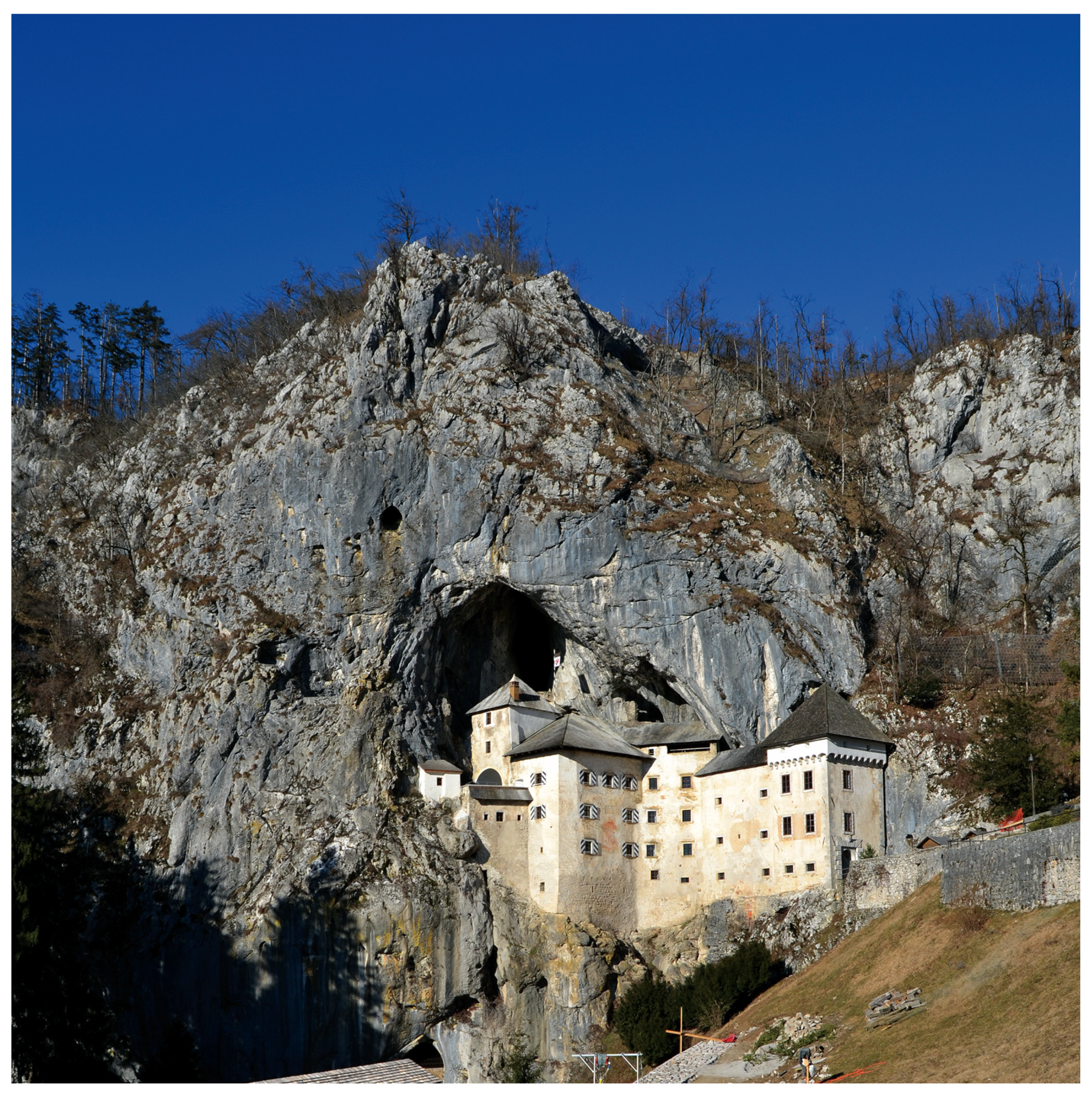
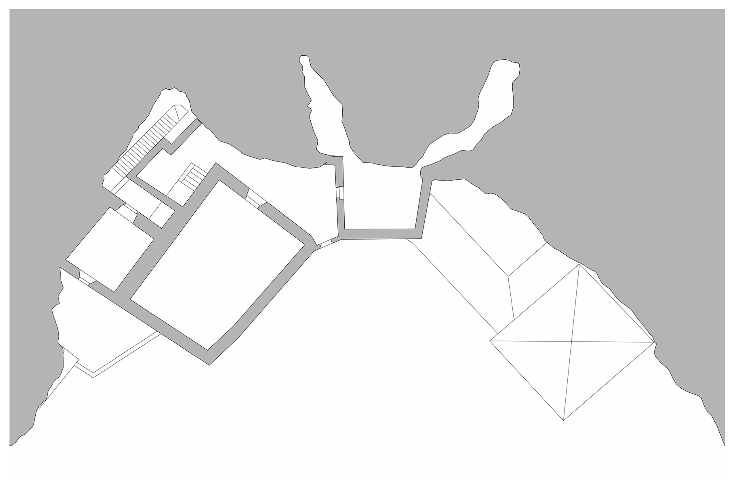
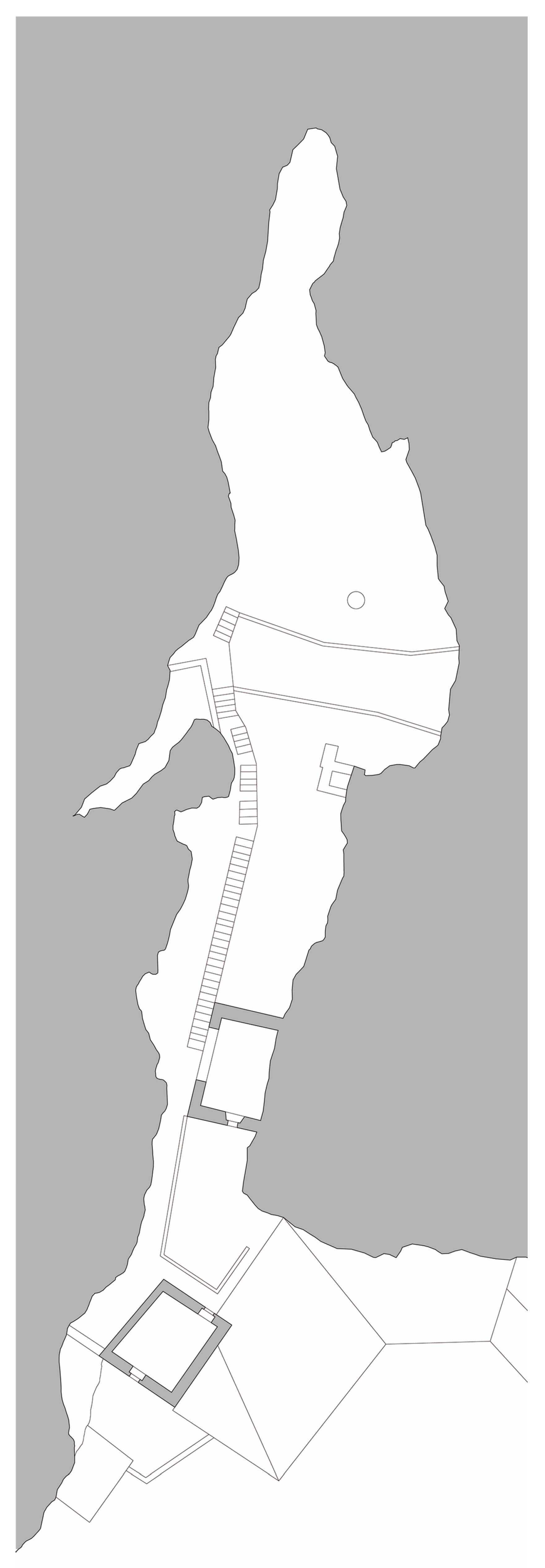
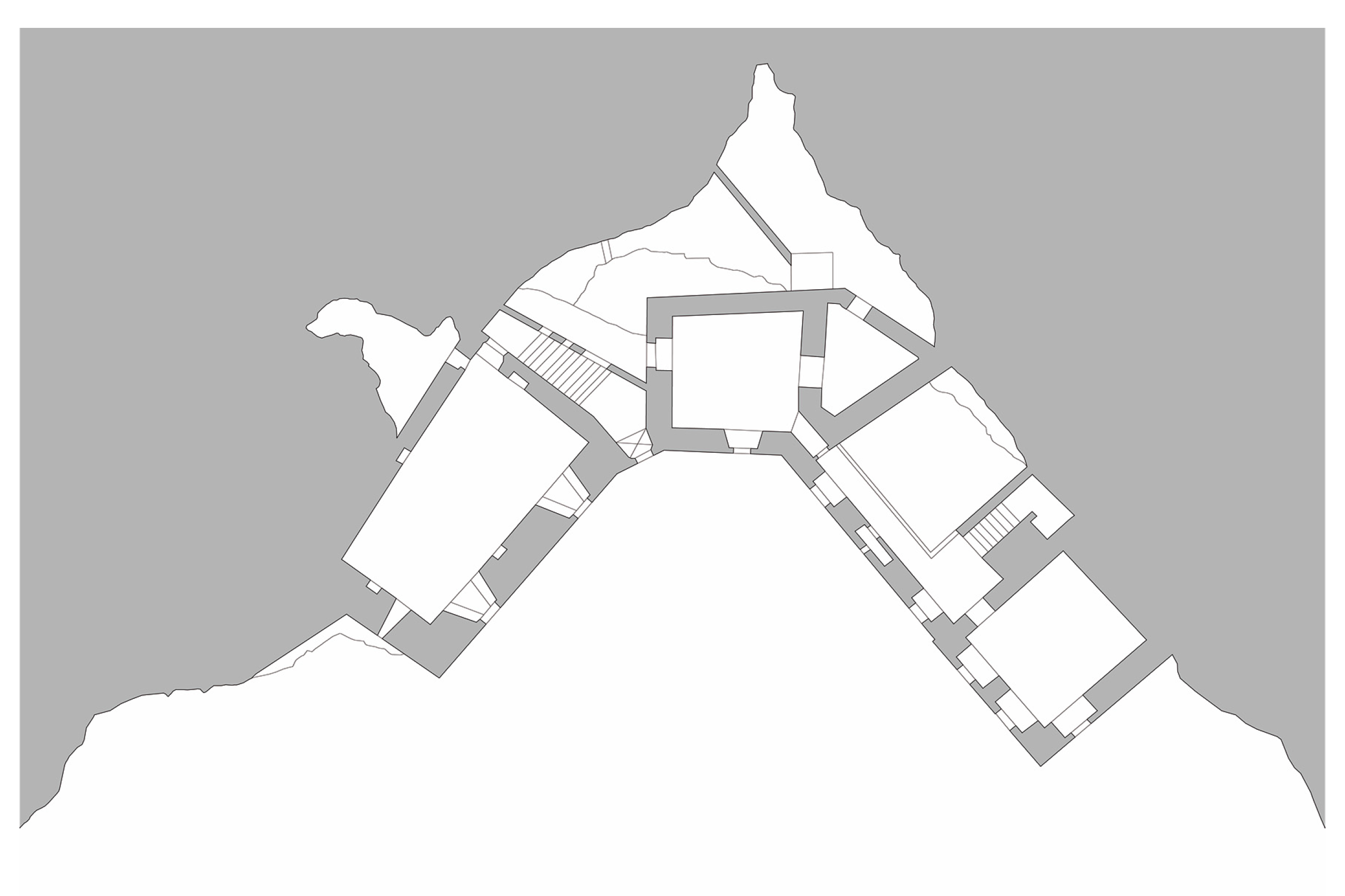
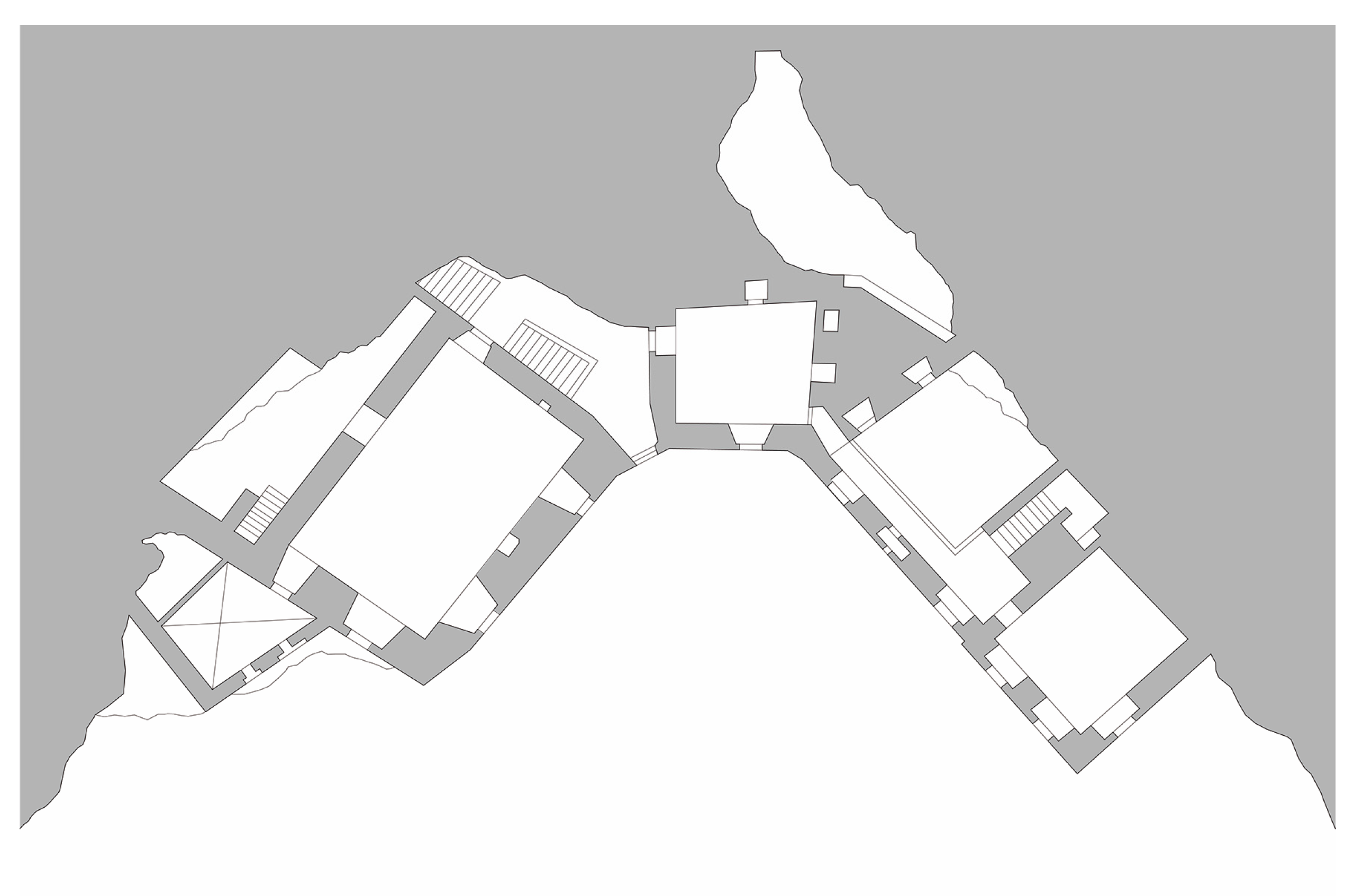
2. The Image of the Predjama Castle

Predjama Castle, located in the northwestern village of Postumia, Slovenia, was built in the 12th century and is today the largest cave in the world. The structure is located at the center of a limestone cliff, at the entrance of a cave at 123 m high, above the Lovka stream, which after a rapid rush of water flows into an underground cave. The territory was already inhabited 150,000 years ago by one of the oldest cultures in central and southern Europe. It is well known that the Romans had established one of the cornerstones of their fortification system and in the Middle Ages, through this land and sea route, timber and other materials were transported to the Adriatic naval ports. The scenic setting at the base of the Castle has an entrance 25 m in depth with respect to the main tread. The portion of the cave closest to the pass was used in the Middle Ages as a horse stable and hence the current name of “Scuderie”. This hypogeum section is also an important archaeological site dating back to the Stone Age that can be reached from within the manor through 250 steps. The oldest part of the Castle is, however, completely concealed in the cave roof and is called “Tana of Erasmus” derived from the historical events of the entire fortified complex. Accessible through a wooden balloon leads to the hut of the Erasmus rider where there is the water collection tank and, on the rocky wall, an observatory on the valley of great strategic military importance. The cave opened 500000 years ago following an earthquake with bridges and stairs close to the rocky wall inside which the river Lovka underneath. A secret path excavated in the bare rock, now closed by a masonry wall, allowed outside communications without being seen by the local community, in the underground cave about 6 km long, with ramps and tunnels arranged on the five floors of the entire structure fortified. In the outline of the research path, it is interesting to trace the historical events that have necessarily influenced the forms and structures of the architecture. The siege of the fortified structure began in 1350 by the Austrian dukes, in 1398 by the troops of Aquileia, while in 1478 the castle became the property of the rider Erasmus, the most famous inhabitant. The legend tells that in 1483 Erasmus, son of a powerful family of the fifteenth century, father was the governor of the city of Trieste, rebelled at the Austrian crown; he managed to escape from the prisons of the Ljubljana Castle in which he was imprisoned and escaped to the Predjama Castle, where he carried on the siege for about a year. Assassinated by order of Gaspar Ravbar, Lord of Trieste, who sought to starve the Knight Erasmus, in 1567 he was bought by Hans Kobenzl, an Austrian knight of Carinthia, and in 1570 by order of Ivan Kobenzl, he was reworked following the dictates era and assuming today’s forms. In 1810 the castle passed to Count Michele Coronini and in 1846 it was bought by Prince of Windischgrätz. Its descendants remained owners until 1810, that is to confiscation by the State after World War II. The interior of the Predjama Castle is characterized by simple features and simple features, but the location inside the limestone cave is certainly unique and suggestive in its kind. The most important venues of the Castle are the torture room, the kitchen, the sacristy, that is, the place where the priest lived, and the main hall overlooking the inner chapel (Figure 2, Figure 3, Figure 4, Figure 5 and Figure 6).

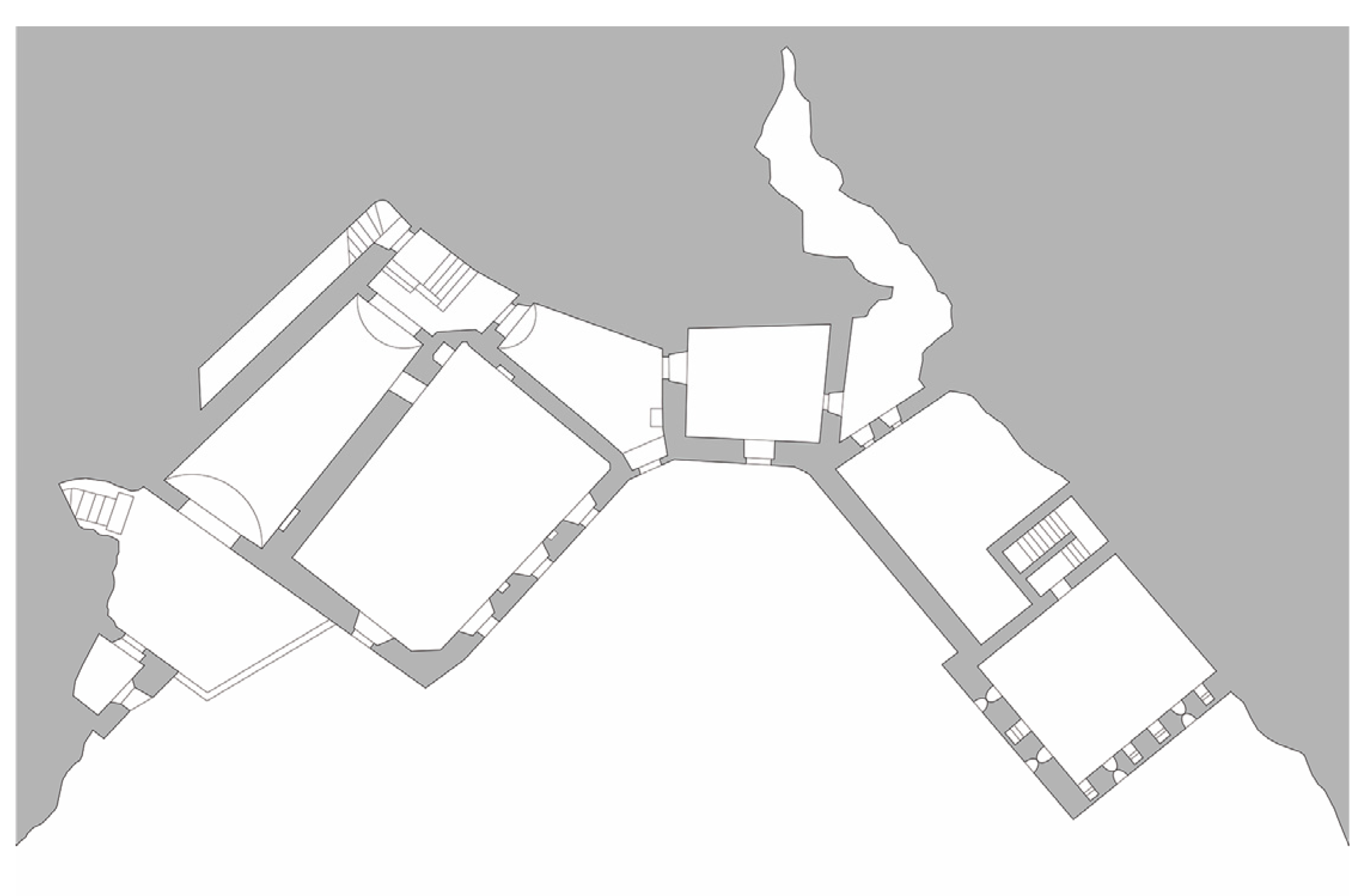
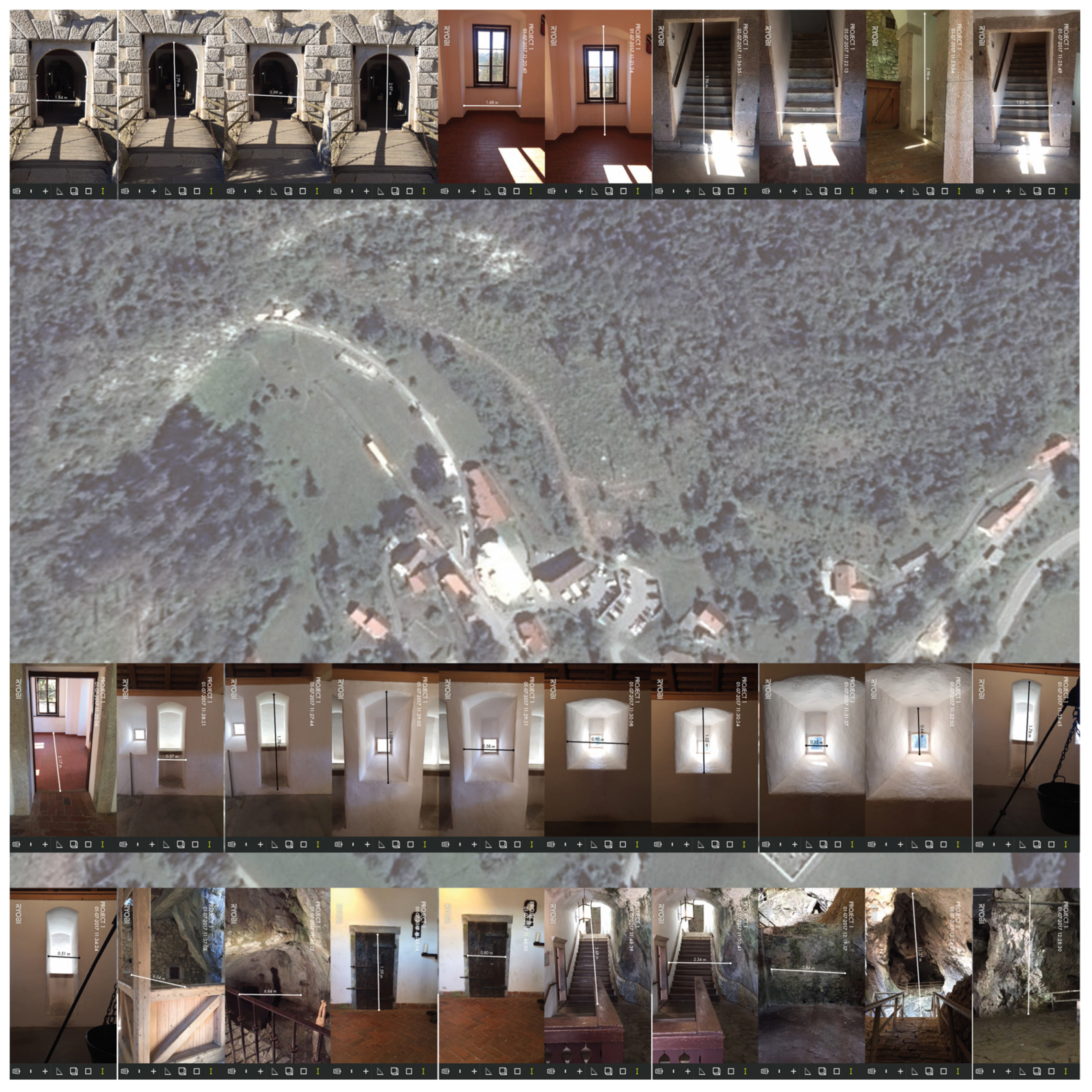
3. Methods and Instruments for the Digital Survey

Predjama Castle’s representation activity has been set up by providing, at an early stage, the execution of a survey extended to the entire architectural body and surrounding natural caves in order to define the geometric model; subsequently, in a second reconnaissance and restitution campaign of survey, measurements were made of architectural details, timber flooring and coverage structures and geo-reference of the digital model. In addition, photographic documentation was produced, in addition to bibliographic, archival and iconographic surveys. In this context of the representation, the photographic image, as well as constituting a database value to which it can be drawn even after the important phase, makes it obvious that the static figurative data may be interpolated with dynamic data elements [4]. For site knowledge activities, account was taken of the use of Ryobi laser (Figure 7) equipment applied on portable computer support, both tablets and smartphones, enabling immediate viewing of the image data on the photo taken by the media, transforming this last in a dynamic data [5]. The use of such photographic technology becomes a major tool since it contains both the measurement data and the geographic coordinates associated with the device used, as well as information about the date and time of the survey campaign execution. The activity aimed at knowledge of the site also required the interpolation of two monthly techniques: GPS and 3D laser scanning technology, which, as we know, extract the data needed to obtain the morphology of the artifact and view, then, in three dimensions. Interrogating point clouds, suitably calibrated and parameterized, allows you to view information that is not easily detectable with the naked eye or with traditional instruments [6]. Constructive abnormalities, wall discontinuities, additions, subtractions and modifications are thus clearly legible and are therefore functional to the actual understanding of the factory in its complexity, in its being a palette of stratified signs over time. The subsequent activity has resulted in a larger scale to work on individual environments inside the Castle itself and, with the three-dimensional restitution, it helps to highlight not only the issues related to the structural behavior of the architectural box, but also all that concerns the problems present on adjacent fronts the same masonry. For the discovery of the Castle’s structure in the cave it was necessary to use the laser scanner, especially for the knowledge of the rooms inside the Castle, since many premises are chained together and have a relationship with the cave itself and then with the limestone rock. The various spot clouds detected locally by the digital instrument have been hooked to each other via link points by appropriate targets, well identifiable within each dot cloud [7].
Through the survey of the building structure and the natural anthropic cavity, using the innovative measurement technologies [8] through the image, we analyze the defensive structure in the territorial complex by offering a knowledge of the Predjama Castle in the natural landscape of Slovenia.

4. Conclusions on the Representation of the Landscape

Drawing an natural landscape and Predjama Castle in Slovenia means recognizing, recording and selecting, critically [9], tracing and distinctive attitudes [10] as entities defined in their membership of the urban and territorial system [11], recognizing relationships that characterize the relationship between architectural components and their environmental context. Landscape design, therefore, consists of an analysis of the relation between man and territory, investigated as an ever evolving body, where it is possible to read the networks of historical, environmental, architectural and economic systems in order to achieve development models [12] for the government of the territory. This research focuses on the architectural, landscape and cultural values of Predjama Castle in Slovenia (Figure 8). The critical analysis of conservation and valorization of the castle allows for the preservation of urban and landscaped heritage, passed through the centuries by the different cultures [13] that have defined the architectural characteristics.

Conflicts of Interest

The authors declare no conflict of interest.

References

  1. Luciano, B. Castelli d’Europa; Hoepli: Milano, Italy, 2005. [Google Scholar]
  2. Stefano, B.; Marco, B. Castelli di Pietre, Aspetti Formali e Materiali dei Castelli Crociati Nell’area di Petra in Tansgiordania; Polistampa: Firenze, Italy, 2004. [Google Scholar]
  3. Stefano, B.; Marco, B. Castelli Medievali a Petra e nel Vicino Oriente, tra Rilievo e Archeologia; Società Editrice Fiorentina: Firenze, Italy, 2009. [Google Scholar]
  4. Corniello, L. Il disegno multidimensionale della città di Ohrid in Macedonia. In Proceedings of the Disegno & Città, Torino, Italy, 17–19 September 2015; Marotta, A., Novello, G., Eds.; Gangemi Editore: Roma, Italy, 2015. [Google Scholar]
  5. Corniello, L. Le “1001” finestre tra passato e futuro/The “1001” windows between past and future. In Proceedings of the AA. VV., EGraFIA 2014: Revisiones del futuro, Previsiones del pasado, Rosario, Argentina, 1–3 October 2014; CUES: Fisciano, Italy, 2014. [Google Scholar]
  6. Cundari, C. Fotogrammetria Architettonica; Kappa: Roma, Italy, 1983. [Google Scholar]
  7. Docci, M.; Gaiani, M.; Maestri, D. Scienza del Disegno; Città Studi Edizioni: Novara, Italy, 2011. [Google Scholar]
  8. Fatta, F. La Rappresentazione Dell’architettura in Fotografia. Analisi Critica e Campi di Applicazione Nell’ambito del Rilievo Dell’ambiente; Ipsa: Palermo, Italy, 1990. [Google Scholar]
  9. Giordano, P. Il Disegno Dell’architettura Costiera. La Costiera Amalfitana_ il Territorio, le Città e le Architetture; La Scuola di Pitagora Editrice: Napoli, Italy, 2012. [Google Scholar]
  10. Giordano, P. L’Albergo dei Poveri a Napoli; La scuola di Pitagora Editrice: Napoli, Italy, 2014. [Google Scholar]
  11. Giordano, P.; Corniello, L. Atlante Grafico e Teorico Amalfitano. La conoscenza e la Modificazione del Paesaggio Costiero; La Scuola di Pitagora Editrice: Napoli, Italy, 2014. [Google Scholar]
  12. Sacchi, L. L’idea di Rappresentazione; Kappa: Roma, Italy, 1994. [Google Scholar]
  13. Zerlenga, O. La Forma Ovata in Architettura. Rappresentazione Geometrica; CUEN: Napoli, Italy, 1997. [Google Scholar]
Figure 1. The Predjama Castle in Slovenia, view of the fortified structure.
Proceedings 01 00897 g001
Figure 2. The Predjama Castle in Slovenia, survey of the ground floor.
Proceedings 01 00897 g002
Figure 3. The Predjama Castle in Slovenia, survey of the first floor.
Proceedings 01 00897 g003
Figure 4. The Predjama Castle in Slovenia, survey of the second floor.
Proceedings 01 00897 g004
Figure 5. The Predjama Castle in Slovenia, survey of the third floor.
Proceedings 01 00897 g005
Figure 6. The Predjama Castle in Slovenia, survey of the fourth floor.
Proceedings 01 00897 g006
Figure 7. The Predjama Castle in Slovenia, survey of the fourth floor.
Proceedings 01 00897 g007
Figure 8. The Predjama Castle in Slovenia, survey of the fifth floor and the “Tana di Erasmo”.
Proceedings 01 00897 g008
Publisher’s Note: MDPI stays neutral with regard to jurisdictional claims in published maps and institutional affiliations.

