Article

Diverse Drought Spatiotemporal Trends, Diverse Etic-Emic Perceptions and Knowledge: Implications for Adaptive Capacity and Resource Management for Indigenous Maasai-Pastoralism in the Rangelands of Kenya

Department of Geography, The Pennsylvania State University, University Park, PA 16802, USA
Climate 2016, 4(2), 22; https://doi.org/10.3390/cli4020022
Submission received: 29 December 2015 / Revised: 29 February 2016 / Accepted: 16 March 2016 / Published: 12 April 2016
(This article belongs to the Special Issue Climate Extremes: Observations and Impacts)

Abstract

:
The study examined the spatiotemporal distribution of drought in the Maasai rangelands of Kenya. The implications of this distribution, in concert with the documented existing and/or projected social and biophysical factors, on critical rangeland resources in Maasai-pastoralism are discussed using an integrated approach. Participatory interviews with the Maasai, retrieval from archives, and acquisition from instrument measurements provided data for the study. Empirical evidence of the current study reveals that drought occurrences in this rangeland have been recurrent, widespread, cyclic, sometimes temporally clustered, and have manifested with varying intensities across spatial, temporal, and, occasionally, social scales; and they have more intensity in lower than higher agroecological areas. An estimated 86% of drought occurrences in this rangeland, over the last three decades alone, were of major drought category. The 2000s, with four major drought events including two extreme droughts, are an important drought period. A strong consensus exists among the Maasai regarding observed drought events. In Maasai-pastoralism, the phenomenon called drought, pastoralist drought, is simultaneously multivariate and multiscalar: its perception comprises the simultaneous manifestation of cross-scale meteorological, socioeconomic, and environmental factors and processes, and their various combinations. The inherent simultaneous multivariate and scalar nature of the pastoralist drought distinguishes it from the conventional drought types, particularly the meteorological drought that predominantly guides drought and resource management in the rangelands of Kenya. In Maasai-pastoralism, the scarcely used (33%) meteorological drought is construed as rainfall delay/failure across spatial and/or temporal scale, and never its reduced amount. Collectively, the current findings reveal that knowledge about drought affects the way the manifestation of this climatic hazard is perceived, communicated, and characterized; hence, ceteris paribus, alongside its spatiotemporal distribution, shapes the nature of the adaptive capacity of and resource management in Maasai-pastoralism. Studies that anticipate enhancing the drought-adaptive capacity of the Maasai should account for cross-scale social and biophysical factors, their processes, and interactions; they must engage the affected inhabitants, and utilize and integrate multiple data sources and approaches. These necessities become more crucial for informing adaptation under the present spatiotemporal distribution of drought as well as in relation to the projected increase in occurrence and intensity of this climatic hazard as the climate continues to change, and as pressures from socioeconomic globalization persistently proliferate into the Maasai’s social and biophysical landscapes.

1. Introduction

“… cattle are so few … look (he points, and then states in a hopelessness tone), this is just an empty boma (boma in this sense is a cattle enclosure, (livestock-kraal)) … it has completely changed … [there are] many empty bomas … cattle herds have reduced…
Ole Seuri
A 61-year-old Maasai elder responding to a question about drought impacts
January 2007
As the climate continues to change, and as the droughts become more frequent and intense, what is the future of Maasai-pastoralism in the rangelands (the term rangeland is used interchangeably with arid and semi-arid lands (ASALs)) of Kenya? Based on the population of people affected, the occurrence of major drought events accounts for over 80% of all the documented natural disasters that plagued Kenya during the last 3.4 decades [1]. In the last seven years alone, five major droughts plagued this country (ibid.). Recorded major droughts, in the rangelands of Kenya and across the greater horn of Africa, have the following common denominators: they are spatially extensive and/or prolonged, and they often trigger and/or intensify water shortages, ecosystem denudation, resource conflicts, agricultural losses, livestock mortality, and/or food-crises—often sparking off social and economic disasters [2,3,4,5,6,7]. These deleterious effects reflect the vulnerability of primary production systems and natural ecosystems to droughts. With regard to Africa, these social and ecological systems—these are the building blocks that structure the core livelihood production systems across Africa—are inextricably interconnected into socioecological systems; they influence and feed back into each other. They are also are in constant flux with various scalar and networked socioeconomic happenings. Because of this interconnectedness, any deleterious drought impact on one inevitably has ripple effects on the other. For these reasons, drought is the most devastative climatic hazard, disrupting lives and livelihoods in the rangelands of Kenya, and indeed across Africa. In fact, the Millennium Ecosystem Assessment of the United Nations [8] has termed drought the “silent killer” in Africa. Devastation by this climatic hazard is likely to intensify as occurrences of major droughts become common as the climate continues to change. Whether the occurrence of extreme drought events could become a regular happening, in the very near future, in the Maasai rangelands of Kenya remains unclear.
Apropos this last point, coarse-scale projections indicate that, as the climate changes, the frequency with which drought occurrences manifest, their duration, and their spatial extent will increase relative to the present conditions [9,10,11]. It should be noted that a slight change in climate could trigger significant intensity and frequency with which extreme climatic events (e.g., extreme droughts) manifest across the ASALs of Africa [12]. Existing studies generally confirm that Africa will experience these deleterious effects of climate change in an intensified manner, primarily because her key production systems and economic sectors are sensitive and are already vulnerable to changes in climatic conditions; due to its inadequate adaptive capacity [9,10,11,13]; and because her core livelihood production systems are coupled socioecological systems. In addition to being triggered and aggravated by drought, the prevalent inadequate adaptive capacity across Africa has multiple drivers, for example poverty, degradation of the natural resource base, and unfavorable economic and political conditions [6]. Thus, it should be clear that a scenario of intensified occurrences of droughts in Africa will manifest, or is manifesting, against a backdrop of pressures from multiple human-system—these include social, cultural, political, and economic factors—and biophysical factors. Therefore, frequent occurrences of drought, alongside these political and ecological pressures, should be a concern vis-à-vis addressing the factors that influence proper operation of primary production systems in the ASALs, for example pastoralism which buttresses the economies of these ecoclimatic regions, as well as the adaptive capacity of the pastoralists. This concern becomes more crucial because much of the region is under ASALs, because major drought in the region is already recurrent, and because these rainfall-dependent livelihoods have higher odds of being disrupted by the intensified occurrences and extent of droughts as the climate changes. Therefore, an informed understanding of this climatic hazard becomes important if effective mitigation of and adaptation to its deleterious impacts is to be achieved.
In spite of this knowledge, and even with the shared understanding that drought is a common risk confronting pastoralism across the rangelands of Africa, its spatiotemporal distribution, particularly at the fine-resolution scales where the affected live, is scarcely, if at all, documented. With regard to shared understanding, regional fora on climate (e.g., Famine Early Warning Systems Network) provide frequent reports on rainfall disparities, especially in relation to livelihood risks. With regard to scale of drought distribution, the reporting (and documentation) concentrates on broader-scale happenings: thus, descriptions such as “shortage of rainfall in the greater Horn of Africa, East Africa is experiencing drought, drought affected the entire East Africa region, consistently poor rainfall in East Africa, reduced rainfall in most places in Kenya,” are not uncommon in referring to drought occurrence, e.g., [2,3,4,5]. In addition, these reports document the measurement of precipitation in terms of statistical average for a regional event. It is pointed out that rainfall in this region is highly variable across spatiotemporal scales [6], and therefore the usage of mean is plausibly deficient. Another common shortcoming evident in studies on drought is their reporting of drought as a given, as a shared concept, as if it has a universal definition—therein rests a flaw in efforts geared toward management of this climatic hazard. It is emphasized that drought has no universal definition [6,14], and therefore, effective mitigation of and adaptation to its deleterious impacts should necessarily be contextualized.
In addition, the effects of drought are rarely discussed alongside concerns of climate change and/or cross-scale pressures generated from multiple human and biophysical realms. Rather, these effects are discussed in isolation. Consequently, how the existing rainfall-dependent pastoralism will potentially manifest under conditions of climate change–induced droughts, in isolation or together with these non-climatic pressures, remains unclear. Studies that anticipate understanding and informing about the drought-adaptive capacity of the pastoralists should account for both climatic and non-climatic pressures across scales. To achieve this need, such efforts should start by understanding drought—vis-à-vis its nature, manifestation, and dynamics—for one cannot manage that which one does not understand. Apropos this last point and the aforementioned concern, salient questions arise, viz., (i) how is the phenomenon called drought perceived in Maasai-pastoralism?; (ii) Do the Maasai’s perceptions, concepts, or ideas concerning drought differ from the conventional definition of drought, and if so, in what ways?; (iii) How is drought occurrence, in the Maasai rangelands of Kenya, distributed across spatial and temporal scales?; (iv) What are the implications of drought perception—as defined by the Maasai and conventionally—and its spatiotemporal distribution on the adaptive capacity of and resource management in indigenous Maasai-pastoralism across these rangelands? To answer these questions, this study draws insights from the affected—those living with the drought, the Maasai inhabitants—and from the “external analysts” via instrumental data and archives. This study examines the spatiotemporal distribution of drought in the southern rangelands of Kenya. An integrated perspective is used to explain how this distribution, alongside the influences from pressures of the documented existing and/or projected human and biophysical factors across scales, is altering, or could alter, the feasible operation of Maasai-pastoralism and the adaptive capacity of the Maasai pastoralists.

2. Data and Methods

2.1. The Study Area

The study site for this work was the Kajiado District, and it is located in the southern rangelands of Kenya (Figure 1). The district occupies an area of approximately 21903 km2 [15,16,17] and is entirely in the Rift Valley Province. Kajiado records an average temperature range of between 25–27 °C, and a mean annual rainfall of 500–1250 mm with ca. 90% of the district receiving less than 700 mm. Rainfall received in Kajiado is bimodal, meaning it occurs in two distinct seasons: short rains (October–December: ca. 375 mm/year) and long rains (March–May: ca. 625 mm/year). The district has diverse agroecological zones, but it is predominated by semi-arid landscapes [16,18,19]. Kajiado District generally rises from 500–2500 meters above sea level (m a.s.l), with much of the region standing at an elevation of about 1000 m a.s.l. [16,20].
The region is sparsely wooded savanna grassland that hosts a large population of livestock, and supports a high diversity of wild animals, all of which are widely dispersed across the area (author’s long-term field observations, [16,18]). Pastoralism, tourism, and agriculture are the main economic activities [16,18]. The major livestock reared in Kajiado includes cattle, sheep, and goats, which occur in all administrative divisions. Farming predominantly occurs in the ecologically high potential areas, and is rain-fed and/or irrigated. Permanent water sources in Kajiado are scarce. The main source of water for domestic use, particularly among the Maasai, is mainly shallow wells. It must be pointed out that, although Kajiado has several streams, most of them are seasonal, and are utilizable only in the rainy seasons. The surface water availability is highly variable and usually inadequate to meet the needs of both livestock and humans.

2.2. Data Acquisition, Management, and Approach

The study acquired data covering all divisions from participatory interviews with the Maasai’s household (N = 120) and key informants, discussions with focus groups, field observations, and retrieval from archives and rainfall station measurements. Randomized households were interviewed until the desired sample size was achieved (N = 120) in an in-depth study. This sample size is adequate toward ensuring robustness of the statistical contrasts employed—Stevens [21] specify that a reasonable sample size entails 20 observations per independent variable—for location and time, both independent variables. The study is a part of the district-wide project on effects of drought on Maasai-pastoralism. Further information on data acquisition and analyses is detailed in Mwangi [6]. It is pointed out that any data and information gathered for the district-wide work is beyond the scope of this paper and is, therefore, not reported herein; instead it is detailed in other relevant publications, e.g., [6,22,23,24]. For the purpose of this study, data for the period 1961–2006 and 1983–2006 is, respectively, denoted as long- and short-term; and the period before 1983 and after 2006 is denoted as pre-1983 and post-2006, respectively. The usage of 1983 as a baseline for the survey data is based on the recall capacity of the respondents—all households interviewed during the pilot study, which preceded the wider project, were able to recall with ease the events dating back to 1983—; 1961 was the baseline on available and continuous rainfall station data.
This study is participatory in that those living with drought and by the same token, Maasai pastoralists, were engaged in the design of the survey instrument and in data acquisition for this work. The study engages an integrated approach, vis-à-vis methods and tools utilized in data acquisition and analyses, toward understanding the distribution and perception of drought.

2.3. Methods

The acquired social and biophysical data was organized and processed, and summaries were obtained before subjecting the data to any formal statistical analyses. Skewed data were transformed accordingly before statistical analysis. Unless otherwise stated, the measure of variability is the standard error of the mean; the alpha is set at 0.05 in all cases. The likelihood ratio statistics (chi-square, χ2) were used to assess the significance of the explanatory variables. Variables about socioeconomic factors and drought type were ranked on nominal scale depending on their importance. All available instrument data on precipitation for Kajiado was used to discern spatiotemporal trends of rainfall. The raw data on rainfall was positively skewed, and consequently, it was log-transformed to ensure normality before effecting statistical analyses.
Notably, the current analyses for climatic variables contain random and fixed effects as well as repeated measures. Consequently, a mixed effect model was fitted, followed by a Tukey adjusted t-test for multiple comparisons among locations and years whenever the F-test was significant [21]. This model also has inbuilt capacity to account for missing values, for example rainfall data contained some missing values owing to the closure of some weather stations, while in some cases it was due to the collapse of rainfall gauges, by using all available data on the subject instead of ignoring it. Since meteorological drought is a derivative of rainfall, I used the established procedures, namely the Standardized Precipitation (rainfall/drought) Index (SPI) [25,26], to filter out drought events and to compute spatiotemporal trends.
Spatial autocorrelation was used to analyze local precipitation to help highlight the spatiotemporal trends of specific drought events. For this work, since the precipitation mean used is varying and known, a simple Kriging (a geospatial autocorrelation technique utilized to interpolate the value of a random field) with variable local means from all available instrument data was used. Details about the Kriging technique are widely documented [27,28,29,30,31]. Here, the available data points were rendered as a weighted sum—this minimizes variance and ensures that the interpolation is unbiased—and subsequently utilized to estimate values for various desired locations. Kriging geospatial autocorrelation accounts for and unravels the spatial dependence of locations affected by drought (that have closely related data). This technique simultaneously produces a prediction surface and provides some degree of certainty and accuracy of the obtained predictions. It is emphasized that the nature of the mean (of the variable in question, e.g., rainfall for this case) used dictates the type of Kriging applied: thus, whenever the mean is constant and known, constant but unknown, or depicts a polynomial function of spatial coordinates, then simple, ordinary, and universal Kriging are respectively applied (see [25,28,29,31,32] for more details on Kriging and similar geospatial techniques). For the current study, simple Kriging with variable local means [28] was employed because the rainfall means are variable [25]. All available instrument data was used, and was prepared in SAS (SAS Institute Inc., Cary, NC, USA) before applying geospatial autocorrelation. The use of geospatial techniques in examining the spatial distribution of precipitation is not unique for this study, but has been used in different geographic or topographical regions, for example the USA, Canada, the UK, Italy and Spain [30,33,34,35,36,37].
Respondents liberally identified various characteristics related to the occurrence of drought; where appropriate, they ranked the factors and/or magnitude of the events based on a pre-prepared questionnaire whose structure was guided by recommended formats and information derived from established protocols detailed in works on similar or closely related subjects (mainly, [38,39,40]). The direct engagement of the Maasai pastoralists is based on the understanding that the affected communities are active participants in defining their adaptive capacities to hazards [41,42].
Basic exploratory data analysis was performed on each variable, followed by a multiple comparisons test to examine the differences between and among variables. Except for the geospatial autocorrelation, all analyses were done in SAS (SAS Institute Inc., Cary, NC, USA). Proportion value (Pv) for the various categorical data was calculated; it depicts the proportion with which the factor or the event was cited (0 = unmentioned, 1 = mentioned by all). Also computed was the Scaled Importance value (Sv): a three-point Likert scale estimate of a respondent’s ranking of the factor or magnitude of the meteorological event based on his perception (1 = low, 2 = moderate, 3 = high). Pv and Sv show the importance and relationship of the various variables vis-à-vis their overall contribution to the issues in question based on views and experiences of the drought-affected population—the Maasai pastoralists. This method of classifying a response is advantageous because of its capacity to capture the trend of the variable within and across the study population [39,40].

3. Results

3.1. Results from Instrument Data

The annual trend of precipitation based on instrument data is shown in Figure 2a. From this figure, it is evident that several drought events occurred during the period 1983–2006. This period, 1983–2006, is used here for the purpose of comparing instrument data (this section) and the presently available participatory survey data (see Table 1 and Section 3.2). It is pointed out that data for drought years pre-1983 and post-2006 are available (Figure 2b)—pre-1960s draws from proxy records indicating modern-day Kajiado (e.g., southern Maasai regions or reserves, olkejuado, southern Maasai rangelands) and alluded to later in the discussions (in this paper). The temporal and spatial contrasts for drought years are significant (p < 0.05). These droughts were of different magnitude that ranged from normal (e.g., 1986) to extreme events (e.g., 2005). Notably, most drought events were often preceded and/or followed by periods of rainfall that was on the rims of the average bounds. Nonetheless, there were exceptions, for example the 1999 drought was preceded by a flooding rainfall event. Overall, an indistinct temporal trend of drought is obvious. However, an almost decadal trend for extreme drought events (1984/1994/2005) is evident. Similarly, a biennial trend for normal drought events is notable, particularly in the 1990s (i.e., 1992/1994/1996). In addition, some recent events were consecutive (e.g., 1999–2000–2001), and consecutive drought events were also documented for the pre-1960s. The longest consecutive drought events occurred in 1900–1919 (seven years), 1950–1959 = 1980–1989 (six years), and 1880–1899 (five years) in that order; and the decade 2000–2009 has the most sets of consecutive events (see details below Figure 2b). Regarding consecutive droughts, two consecutive events are frequent (Figure 2a,b). It is worth noting that the 2000s, 1990s and 1980s recorded five, four and two major drought events, respectively (SPI range: −3.9 to −1.3); the 2000s included three extreme drought events (viz., 2000 (−2.5), 2001 (−2.6), and 2005 (−3.9) and 2009 (Figure 2a,b); the 1990s included one (viz., 1994 (−3.4)), and the 1980s two (viz., 1983 (−3.2) & 1984 (−3.6) (Figure 2a). Out of the 14 drought events recorded between 1983–2006, only two (14%) drought events were within the normal bounds (Figure 2a), and both fall on the edge of major events (SPI very close to −1.0, Figure 2a). Similarly, existing records indicated the occurrence of major drought in the pre-1960s, post-1960 but pre-1983, and post-2006 (Figure 2b).
The spatial trend of selected drought events is shown in Figure 3. The spatial intensity with which different drought events manifested differed conspicuously (range: normal (ca. 0) to severe (ca. −5.0). For example, the average for the 1994 drought event (1994-Av, Figure 3) has a smaller intense drought space—drought space denote micro-regions covered by a meteorological drought—over Magadi and Central compared with the long-rains of the same year (1994-Lr). It is evident here that the drought space spanned over much of these two divisions and partially extended to the neighboring divisions in the long-rains of 1994; this intensity is almost akin to that observed using averaged data for 2001 (2001-Av). The temporal (p < 0.05) and spatial (p < 0.0001) values are significant. Overall, drought spaces often had less intensity ((0)–(−0.5)) around Ngong and over the southeastern portion of the district compared with the rest of the district. Droughts were persistently intense over Magadi and portions of Central. Overall, drought manifested with dissimilar mosaics of drought spaces across timescales.
Areas of low agroecological potential (e.g., Magadi) had the most intense drought conditions, while those within high agroecological spaces (e.g., around the Ol Doinyo Orok, Lemilebru-Ingito, and Chyulu Hills; and Mount Kilimanjaro) recorded moderate or normal drought conditions (Figure 3).

3.2. Results from Participatory Surveys

In Maasai-pastoralism, the occurrence of drought is signalled by the manifestation of various conditions and happenings. For example, drought is said to occur when the expected seasonal rains (the long-rains and the short-rains are called Nkokua and Oltumuret, respectively) are very patchy, delayed, stop early, and/or are low, or when there is a heightened aridity during the dry season (also referred to as and called Oloirurujuruj, which translates to the drizzling season or the season of drizzles) (Table 1). Other factors such as intense drying up and shortage of pasture signify the occurrence of this climatic hazard. This does not necessarily mean that all these factors have to manifest concurrently for a condition to be regarded as drought; rather, they occur in various combinations of types and intensities. For example, although the majority of the Maasai’s households perceive the continual inability to purchase livestock input and/or households’ food as indicators of drought conditions, they do not rank high as the major drought indicators. All respondents emphasized that the shortage of pasture and failure of seasonal rains in isolation often signify the occurrence of drought (Pv = 100%; Sv > 90%, Sv ≥ 2.45 ≤ 3.00, N = 120, p < 0.05, Table 1). The combination of these two variables is also significant in defining drought. For example, delays, failure, or early termination of seasonal rains and the depletion of pastures across spatiotemporal areas and/or the declined productivity of livestock, particularly cattle, are widely used together to define drought in this system (Pv = 100%, N = 120, p < 0.05, Table 1). Meteorological and non-meteorological components in isolation account for 33% and 40%, respectively, of all recorded drought variables (Table 1, p < 0.05). In defining drought based on dynamics of meteorological (rainfall) factors alone, the reduction in spatial extent (65%, Sv ≥ 1.45 ≤ 2.44, p < 0.05), altered timing and/or complete failure ( >90%, Sv ≥ 2.45 ≤ 3.00, p < 0.05) of rainfall are the most widely used variables. The usage of a reduced amount of rainfall as a drought variable is conspicuously nonexistent. Note that a unanimous description of drought is non-existent among the Maasai, and the rainfall amount alone is never used to indicate drought occurrence. The presence of drought is mostly detected by one’s observation of the environment (Multiple Respondents, 2006, 2007). It is pointed out here that, among the Maasai, knowledge about some of these variables that indicate the occurrence of drought has been handed down through generations.
The temporal trend of drought occurrences based on survey data is shown in Figure 4. Evidently, several drought events were observed during the last 2.4 decades, ending in 2006. These droughts are of various combinations of Proportion value (Pv) and Scaled Importance value (Sv). For example, although the Pv for 1996 is similar to that of 2000, a higher Sv for the former is identifiable. Some drought years, for example 1984 and 2005, were frequently mentioned and highly ranked (Pv ca. 1.00, Sv ≥ 2.45 ≤ 3.00). A drought year such as 1986 was moderately mentioned and lowly ranked (Pv = 0.50, Sv ≤ 1.44). Notably, the majority of drought years with Pv ≥ 0.75 also have high Sv (1.45 ≤ 3.00). A perfect Pv manifested only for the years with the highest range of Sv; nevertheless, the converse does not necessarily apply for moderate and/or low Pv years. Notably, the period 1983–2006, ca. 10 major droughts (Pv ≥ 50 and/or Sv > 48%, Sv ≥ 1.45 ≤ 3.00, N = 120, p < 0.05, Figure 4), including two-extreme droughts (Sv ≥ 2.45 ≤ 3.00), were observed. The 1980s had three major droughts including one extreme drought; the 1990s had four major droughts; and the 2000s recorded five major droughts including one extreme drought.
Some moderately mentioned years have low Sv (e.g., 1987); others (e.g., 1991) have low Pv but moderate Sv. Some years (e.g., 1998) were plainly unmentioned (Pv = 0). The overall annual trend of the occurrence of drought, based on respondents’ observations, is indistinct. However, it is evident that some drought events, particularly from the late 1990s through the mid-2000s, were clustered. Taken together, data from the instrument and survey show that drought occurrences in Kajiado were frequent, variously cyclic, and sometimes clustered.

4. Discussions

4.1. Spatiotemporal Distribution of Drought

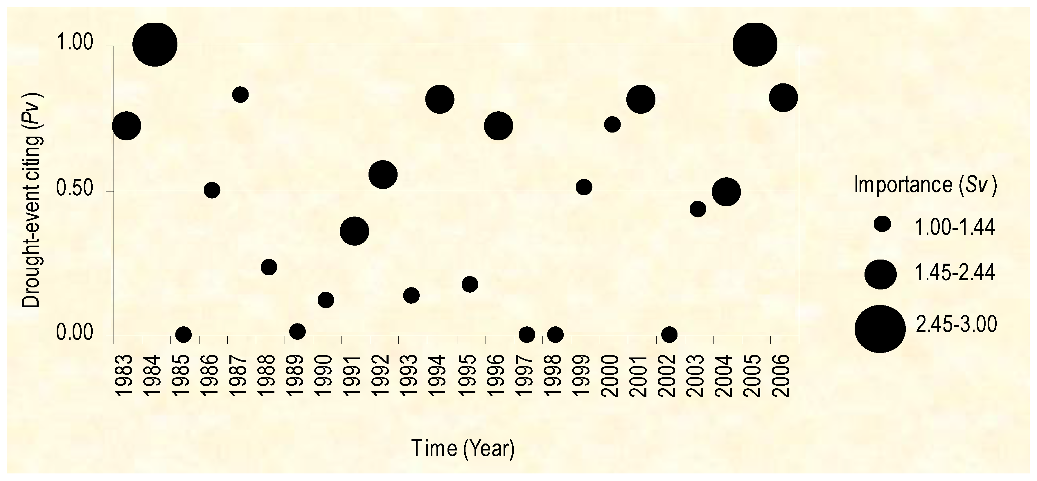
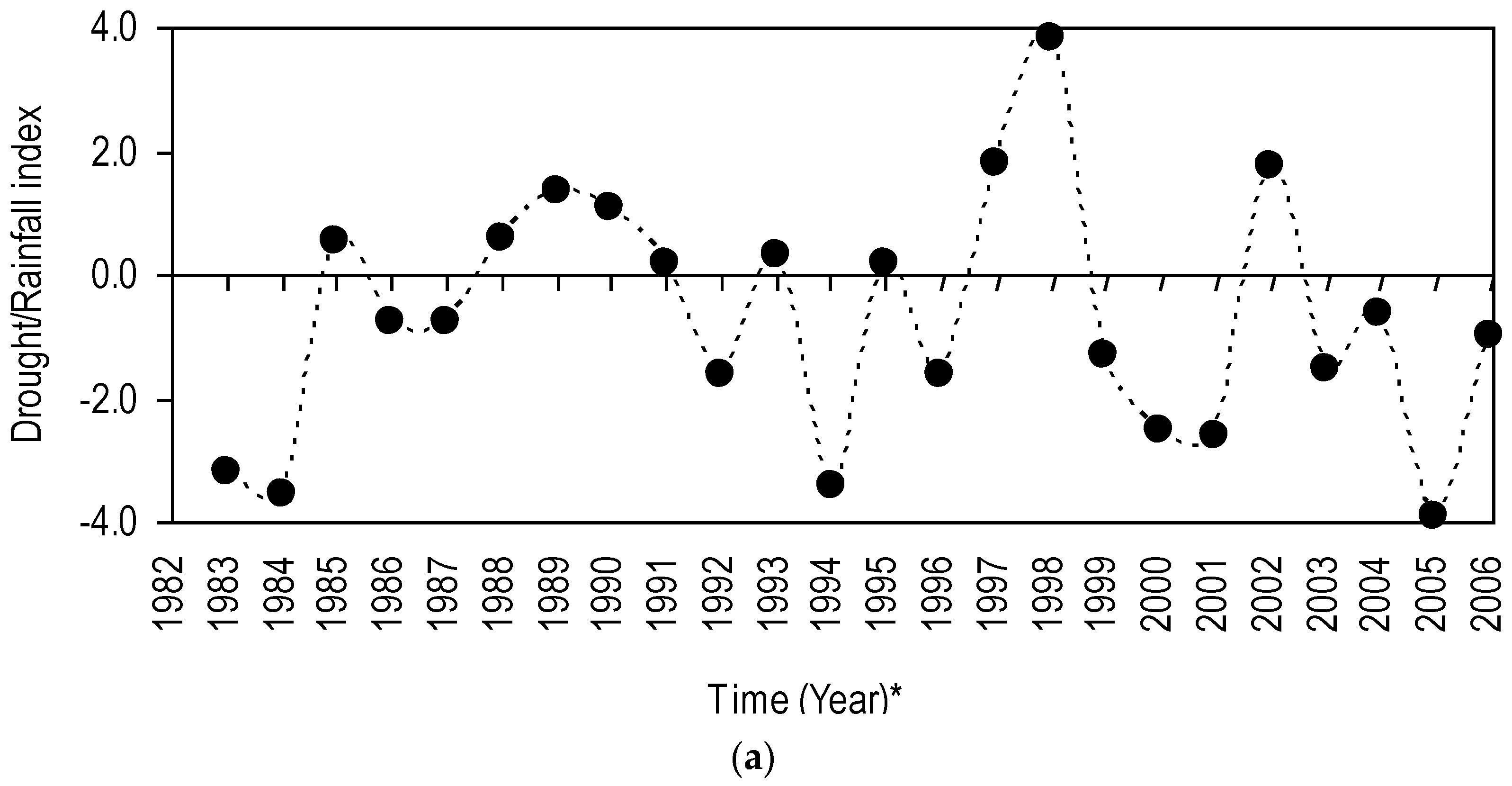
The empirical evidence from the current study shows that, during the period of 1983–2006, as well as pre-1983 and post-2006, occurrences of drought in Kajiado were frequent and had indistinct spatiotemporal annual trends (Figure 2a,b). The significant temporal and spatial contrast (p < 0.05) for drought further attests to this variation among the drought years. They were also widespread, variously cyclic, and sometimes temporally clustered (Figure 2a and 
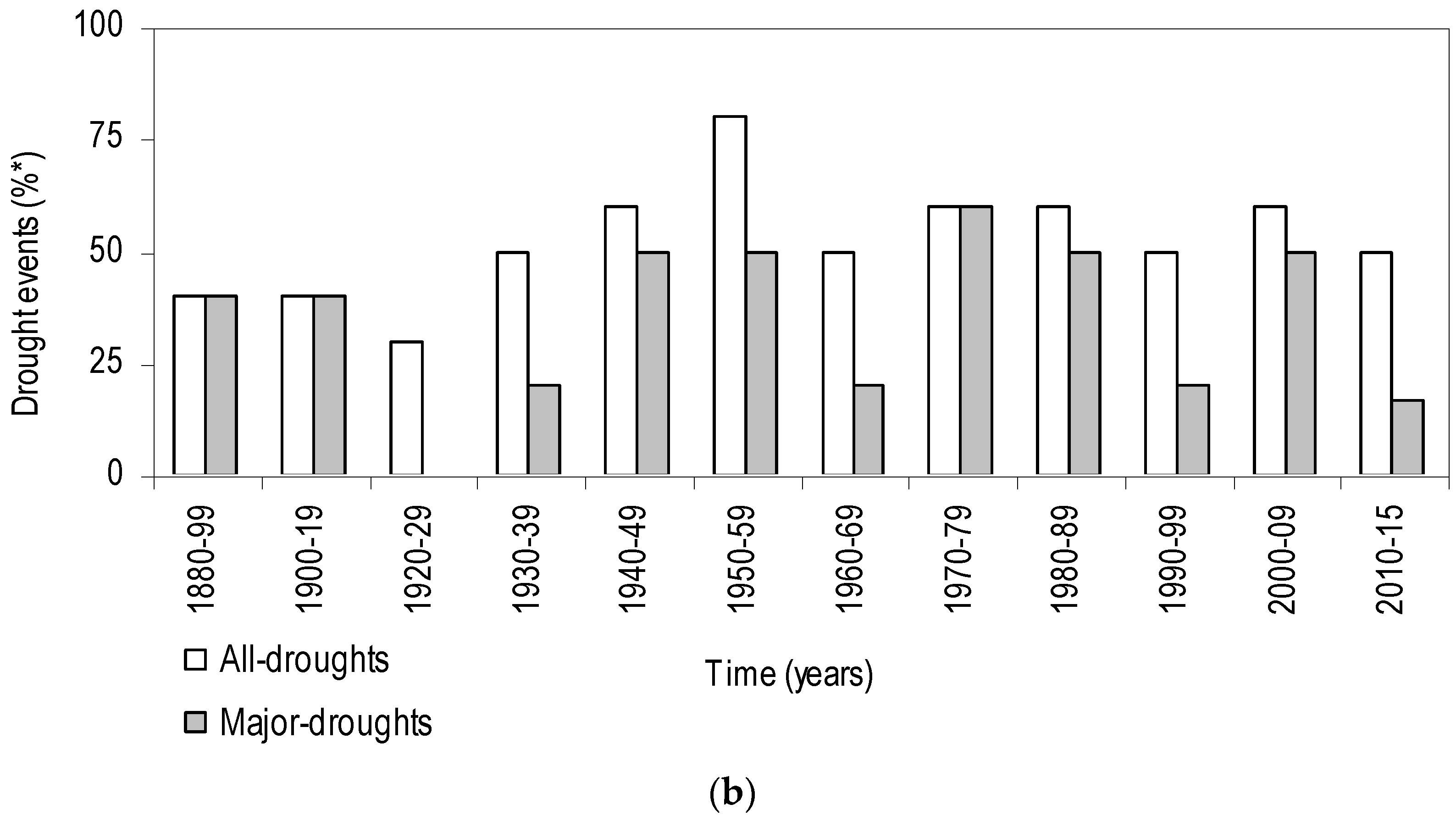
Figure 4). The current empirical evidence also reveals that an estimated 86% of drought occurrences in this rangeland, from 1983 to 2006, were in the major drought category (Figure 2a). Major droughts have occurred in this rangeland pre-1983 and post-2006 (see Figure 2b). In fact, each decade in the 1940s, 1950s, and 1970s recorded over 50% of the events, which translates to a minimum of five drought events in 10 years. It must be noted that this frequency of and spatial vastness of drought corroborates well with the recorded drought events, mainly major and extreme drought, that have plagued Kenya and the greater horn of Africa [3,4,7]. This finding indicates that this climatic hazard is a common occurrence in this region. This interpretation accords well with the conclusion that drought is a normal climatic occurrence across the rangelands of East Africa [43,44]. The indistinct spatiotemporal annual trend of drought events does not only indicate that droughts manifested with differential intensity across the district annually, but also that they were temporally unpredictable. This finding, in concert with the region’s characteristic high rainfall variability [6,44,45], indicates that this rangeland harbors climatically diverse micro-regions. It is instructive to explore how the frequent occurrences of major drought events manifest within these micro-regions: this is discussed later in this paper.
The evident manifestation of biennial and decadal cyclic drought events (from Section 3.1, such manifestations are also evident for the period pre-1983 (biennial, e.g., 1972/74/76, consecutive and decadal, e.g. 1960–1961/1971–1972/1980–1981) and post-2006 (consecutive and biennial, e.g., 2010–2011, 2011–2012, and 2014; and decadal, e.g., 2009)) indicates a potential presence of a recurring drought-forcing, and, by extension, it suggest predictability of occurrences of this climatic hazard in the region, if such forcing is deciphered. It must be pointed out that, with regard to climatic forcings across East Africa, extreme climatic events are triggered by specific teleconnections with El Niño-Southern Oscillation (ENSO) [46,47], mainly El Niño for extreme rainfall, and La Niña for extreme droughts. This means that, by monitoring the behavior of ENSO and other forcings and/or variables, the predictability of meteorological droughts for the region can be improved. Moreover, it is highlighted that, since the established period for discerning change in climate is 30 years on average of weather [48], the current study, having documented events spanning over 10 decades, provides sufficient initial data to contribute, in part, to such efforts. Beside their cyclic manifestation, droughts were sometimes temporally clustered, with, occasionally, the cluster containing an episode of extreme drought and often being preceded by below-average rainfall (poor rains) conditions (Figure 2a,b). Apropos this last decade, the current empirical evidence reveals that the two extreme drought events (2005 and 2009) were clustered around four events of droughts or poor rains (Figure 2a,b and Figure 4), [3,4,6]. The temporal clustering indicates that drought occurrences have been consecutive, and that their return period has shortened. This consecutiveness is attested in survey data (Figure 4) where drought years were continuous.
It is pointed out that the occurrence of some of consecutive drought years contains a paradoxical interpretation: it could signify one major event that spanned the chronological scale, for example 2000 and 2001, 1983 and 1984 (Figure 2 and Figure 4); it could also signify that there were actually separate events that presented with varying intensities in different places, and therefore, the reporting of drought should account for this connectivity and disconnectivity. This finding reveals the necessity for attaching a shorter timescale, for example a season or number of drought days. Apropos this finding, the strength of the pastoralist drought (see Section 4.2 for definition) is clear: the usage of the variable “delay/early termination of seasonal rains (Table 1)” implicitly indicates drought days, and “failure of long-rains (Table 1)” explicitly indicates a specific season. Similarly, this finding reveals the inherent complexity in the precise determination of the actual time of termination of a given drought.
The evident spatiotemporal pattern of drought at finer-resolution scales and shorter timescales, particularly the shifted mosaics of drought spaces and the manifestation of cyclic events and clustering (Figure 2 and Figure 3), is rarely documented for this rangeland. The evident cyclic manifestation of droughts, coupled with the understanding that they are locally expected, suggests that they, at the very least, should be anticipated; nevertheless, it begs the question: are they predictable? Thus far, these findings indicate an overall differential occurrence of drought across spatial and temporal scales. The following sections address the aforementioned salient questions—namely: (i) How is the phenomenon called drought perceived in Maasai-pastoralism?; (ii) Do the Maasai’s perceptions, concepts, or ideas concerning drought differ from the conventional definition of drought, and if so, in what ways?; (iii) How is drought occurrence, in the Maasai rangelands of southern Kenya, distributed across spatial and temporal scales?; (iv) What are the implications of drought perception (as defined by the Maasai and conventionally) and its spatiotemporal distribution on adaptive capacity of and resource management in indigenous Maasai-pastoralism across these rangelands—and specifically highlight the differences and similarities between and within the data sources, viz. participatory surveys with those living with the drought (the Maasai) and instrument data.

4.2. Spatiotemporal Distribution of Drought: What Trends and Whose Observations?

Results from the current study reveal corroborative as well as divergent outcomes vis-à-vis drought years in two specific modes: among the respondents (see Section 3.2), and between the instrument and the survey data (Figure 2 and Figure 4, respectively). With regard to corroboration, the survey data show that over 50% of the Maasai’s households concurred on over 80% of the total observed drought events during the period 1983–2006. This high concurrence among the respondents is indicative of the spatial vastness of drought events, because the sampling was randomized across the district. A strong consensus is also evident among households regarding simultaneous negative anomalies in seasonal rains and the depletion of pastures across spatiotemporal areas and/or the declined productivity of livestock, particularly cattle (Pv = 100%, N = 120, p < 0.05, Table 1). This finding indicates the inextricable interconnectedness of climatic, ecological and socioeconomic factors in shaping the system of Maasai-pastoralism. Besides the respondents’ corroboration, a consensus between the instrument and the survey data is evident. For example, at the district level, the majority of the drought years evident via the survey data (over 80% of the events, including the cyclic ones, Figure 4) strongly matched those derived from the instrument data (Figure 2a). This strong consensus offers a confirmation that drought actually occurred during the mentioned years, and is a testament to the Maasai’s knowledge about climatic changes occurring in the region in general, and about drought temporal trends within the district in particular, indicating that the perceptions of these pastoralists are not random. It is also a testament to the Maasai’s capacity to interpret and learn about climatic changes occurring in this resource-variable region, which, from a social perspective, allows them to adjust certain components of their livelihood accordingly. This finding, coupled with the evidence that the Maasai’s knowledge about drought is handed down through generations, indicates that their perception about climatic changes and drought trends draws from both indigenous and local happenings and conditions. Indeed, the components of drought, based on the Maasai’s perception (see Section 3.2), reveal diverse factors and processes—for example, “failure of rainfall for two consecutive seasons”, “shortage of pasture”, “continual inability to purchase livestock input and/or households’ food”,—and their various interactions, which define the concept of drought. With regard to indigenous climatic knowledge, and from a policy perspective, Luseno et al. [49], using the case of pastoralists of the rangelands of northern Kenya and southern Ethiopia, advises that it provides useful insights vis-à-vis enhancing the feasibility of conventional meteorological forecasts. Therefore, it must be pointed out that policies and practices for enhanced drought management in Maasai-pastoralism and similar production systems need to integrate emic and etic knowledge.
Besides the aforementioned corroboration, a divergence among the Maasai’s households is evident vis-à-vis the magnitude of the observed droughts. For example, although 1987 was frequently mentioned (>70%) as a drought year, it was assigned a low importance value; in contrast, 2004 was both moderately mentioned (ca. 50%) and ranked. This means that different households perceived the same event, which looks like the same and homogeneous event via the instrument data, differently: this provides a vital insight and a critical entry point 
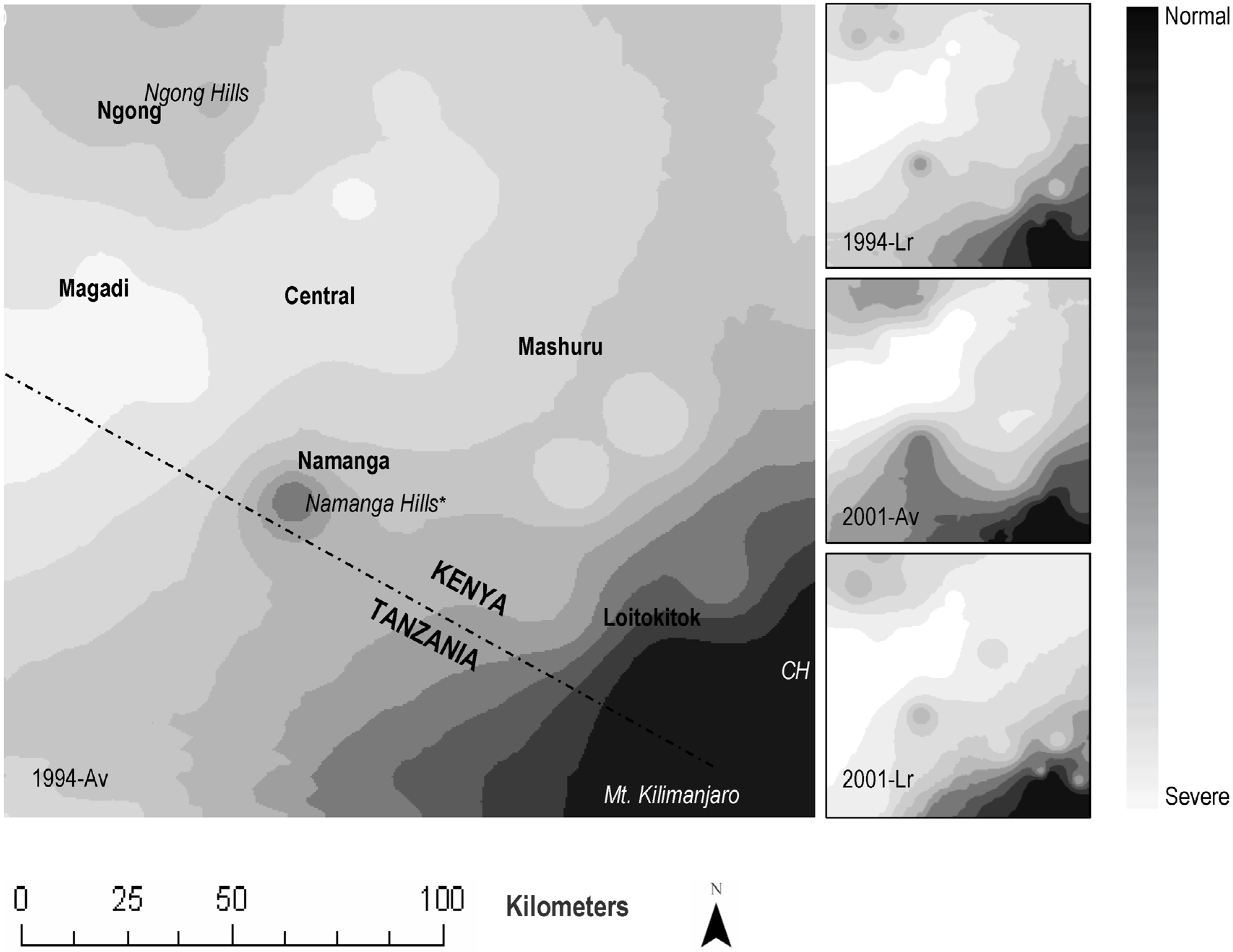
vis-à-vis policy-makers’ and scientists’ intervention efforts geared toward informed drought management. Continuing with this differential perception, this finding indicates that these two drought events manifested with differing intensities across spatial scales because Maasai households are dispersed across the district; and the study design was randomized. The evident significant temporal and spatial contrasts (
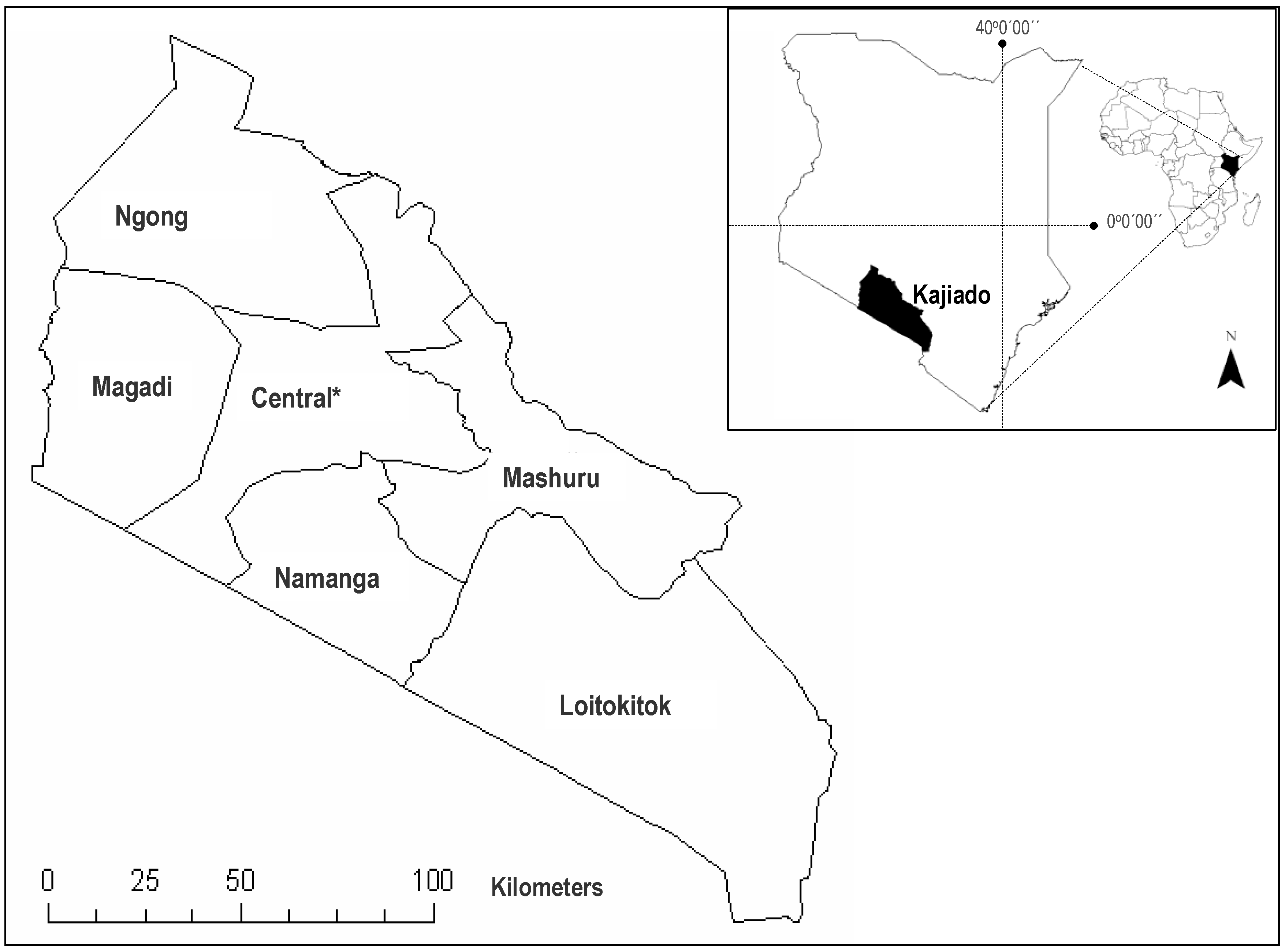
Table 1) further attest to this differential spatial intensity, and so does the analysis via geospatial autocorrelation. With regard to instrument data for specific event analyses via geospatial autocorrelation, drought intensities tracked agroecological zones (AEZ): high-potential AEZs such as around Mount Kilimanjaro [6] experience mild- to low-intensity drought and vice versa for low-potential zones such as Magadi (Figure 3).
The finding suggests that an inhabitant’s location determines his perception about the occurrence and intensity of drought: this can be attributed to the differential drought exposure of critical rangeland resources (CRR)—critical rangeland resources (CRR) are a component of the definition of drought in Maasai-pastoralism—due to the existing variation in environmental spaces, topographic and geological settings, and rainfall that characterize this rangeland. For example, because ecologically high-potential places (e.g., around the Ol Doinyo Orok Hills: Figure 3) tend to harbor forage (e.g., pasture for livestock) for longer periods than other places, in such areas a normal short-term drought, in Maasai terms, could terminate without significantly affecting CRR during that specific year. Consequently, the resident Maasai perceives it as a non-drought year. By contrast, when the drought is spatially widespread, several households simultaneously experience a shortage of CRR, rendering most respondents to perceive such a period as a drought year, and could have designated it as an extreme event, particularly if their socioeconomic sector was impaired significantly. From an ecological perspective, this finding suggests that the manifest diverse environmental spaces, particularly at finer-resolution scales, affect the way the Maasai perceive drought intensity. This understanding sheds light on previously posed salient questions vis-à-vis the Maasai’s perception of the phenomenon called drought, its occurrence, and its distribution, and the consequent implications of this climatic hazard on the management of CRR. Suffice that to help mitigate the deleterious effects of drought, or to enhance the Maasai’s adaptive capacity to this drought, the external analysts (mainly policy-makers and scientists) need to learn about drought from the affected, and in this manner, the local uptake of policy or research findings is likely to succeed.
The Maasai’s designation and ranking of drought year can also be attributed to the way these pastoralists perceive the manifestation of the phenomenon called drought. Drawing from the Maasai’s perceptions (see Section 3.2), drought can be summarized as that condition that occurs when the expected seasonal rains are significantly shortened, or are spatially restricted, or are low; causing shortage of pasture and/or water; leading to insufficient nourishment for and output from livestock and/or reduced household socioeconomics; and/or impairing non-Maasai/non-pastoral social and economic landscapes in the region. It is worth noting that, in addition to the location of the affected, drought impacts on cross-scale social and biophysical landscapes influence its characterization.
It must further be pointed out that drought, in Maasai-pastoralism, comprises its meteorological manifestation (e.g., failure of rainfall) and its cross-scale socioeconomic (e.g., continual inability to purchase livestock input and/or households’ food) and environmental impacts (e.g., pasture shortage) (see Section 3.2). It captures external happenings and conditions, for example the presence of monotonous/lack of vegetables in markets and the failure of crops in farmers’ fields (Table 1). More specifically, it is founded on various combinations of environmental, social, and economic variables and on spatiotemporal variation of seasonal rains, indicating that drought (pastoralist drought), as perceived through the lens of the Maasai pastoralists, is simultaneously multivariate and multiscalar—this is called pastoralist drought for the purpose of this study.
The evident variety of variables that define drought among the Maasai (Table 1) denotes the progression stages of pastoralist drought, particularly when the variables apply to the same event. For example, a drought that occurs due to shortened long-rains alone is less intense compared with one that couples a meteorological event with impaired household socioeconomics. It is worth noting that a reduced amount of rainfall is never construed as a drought occurrence in Maasai-pastoralism (Table 1): rather, drought in the meteorological sense or as a derivative of rainfall, among the Maasai, is comprised of a delay or failure across spatial and/or temporal scale. This finding indicates, apropos drought as a derivative of rainfall, that spatial extent and timing are more important (they are the most crucial variables), and that amount received has little significance. Also notable is the rare usage (33% of recorded drought variables, p < 0.05) of meteorological variables alone in defining the manifestation of drought: in fact, non-meteorological variables alone are widely used in defining drought (40% of recorded drought variables, p < 0.05) in this livelihood production system. This indicates that, when drought creeps in, the Maasais are able to perceive its manifestation on socioeconomic and ecological spaces: these are the crucial dimensions of drought. The high importance attached to defining drought based on the dynamics of meteorological (rainfall) factors alone, the reduction in spatial extent (65%, Sv ≥ 1.45 ≤ 2.44, p < 0.05), logically implies that some places within the rangeland could be receiving rainfall while, at the same time, other places within the same rangeland could experience a drought condition. This interpretation further highlights the existence of the aforementioned micro-climatic patches within the Maasai’s rangeland of Kenya.
That in this system both altered timing and complete failure of rainfall bear equal importance (>90%, Sv ≥ 2.45 ≤ 3.00, p < 0.05) vis-à-vis defining the occurrence of meteorological drought is worth noting. This suggests that the altered timing of rainfall—its delay and/or early termination—has the same effect as complete failure. This interpretation makes sense when taken in the context of reduced pasturage due to land-use change [6] and, hence, inaccessibility to CRR during periods of drought; here, altered timing leads to the shortage of forage for livestock, with consequent reduced socioeconomic returns on one’s household. Similarly, this explanation makes sense when viewed from phenological perspective: grass tends to sprout quickly upon sensing moisture, and therefore both delay/early termination cause this resource to wither and deplete, and so does a complete failure of rainfall. Thus, the timing of rainfall is critical in Maasai-pastoralism. Collectively, these findings denote the spatial, temporal, social, and environmental dimensions of drought, not only as a climatic event, but also when viewed under the lens of a specific indigenous production system, in this case Maasai-pastoralism. Therefore, policies that anticipate benefiting drought adaptation in Maasai-pastoralism should incorporate the various dimensions of the pastoralist drought.
As among the respondents, a divergence about drought years was also evident between the instrument and the survey data. More specifically, results from the instrument data (Section 3.1) captured fewer major drought events compared with the analyses of survey data for the same period, indicating a divergence for some drought years between the two data sources. The manifestation of specific years, for example 1987, as having normal conditions via the instrument data (Figure 2a) and as having drought conditions via survey data (Figure 4) indicates that some drought events that occurred at the finer scale were undetected at the coarser scale. Thus, for example, the 2004 event (Figure 2a) was an average drought condition and a major drought condition, under instrument data and through the survey data, respectively. The variation in outcome under different data sources can be attributed to the differential intensity with which drought events manifested—or were felt—across spatial scale, and it can be explained using the progression of conventional drought-types (further details regarding conventional drought types are well documented, especially by established authorities on the subject of drought, for example Dr. Donald Wilhite (see the various citations in this work and elsewhere)) as well as the structural components of the pastoralist drought. More specifically, drought events depicted by the available instrument data are mainly reflective of meteorological drought because they purely draw from recorded precipitation data. Meteorological drought is characterized by an extended period of below-average amounts of absolute rainfall [14], and is partially silent on other drought types, for example socioeconomic drought. It should be noted that conventional drought types are distinguished based on certain identifiable characteristics [14,50,51], which is beyond the scope of this paper, and therefore will not be explicated upon. In contrast, pastoralist drought goes beyond capturing most of the attributes of the conventional drought types to include various cross-scale environmental, climatic, and socioeconomic components. It is pointed out that the Maasais’ perception of meteorological drought differs from the conventional interpretation of the same: it excludes rainfall amounts (Table 1). This revelation further highlights the contextual understanding of drought, in this case between the instrument and the survey data. The findings further suggest that, whenever it occurs, pastoralist drought affects numerous facets of Maasai-pastoralism over timescales. This is unlike the implication of the isolated manifestation of any of the conventional drought types. Clearly, pastoralist drought is simultaneously a climatic as well as an ecological and social phenomenon, and it is multiscalar and multifaceted. This is not entirely unexpected, because climatic knowledge, including that of drought, among the indigenous inhabitants, particularly across the rangelands of East Africa, has predominantly been shaped by specific livelihood needs, by trends of the rainfall, and by one’s location [49], all of which vary with changes occurring across scales. This variation becomes conspicuous in highly heterogeneous ecozones that the Maasai rangelands comprise: suffice that to manage or monitor a meteorological component of the same based on instrument data is only partially informative vis-à-vis enhancing the Maasai’s drought-adaptive capacity and CRR management.

Same Location, Different Drought: Insights from the Field

Apropos these last points, from the structural components of the pastoralist drought, it should be evident that Maasai pastoralists perceived and rated the occurrence of drought based on pasture and water needs as well as the local spatiotemporal trend of the seasonal rains, rather than on the amounts alone and the intensity of the aridity of the dry season. Therefore, it is plausible that because 1987 was preceded by a relatively dry year, the CRR—mainly water and pastures—were still inadequate for the livestock, and, thus, the Maasai perceived it as a drought year. Similarly, although the instrument data depicted 1994 as an extreme drought year—having a magnitude that was almost akin to that of 1984—it was a period of moderate drought from the perspective of the Maasai. This is plausibly because it was preceded by non-drought conditions, showing that pastoralist drought accounts for the legacies of the precedent conditions rather than solely the present situation. Unlike the pastoralist drought, conventional droughts rarely focus on the timing of the event, but rather dwell mainly on the average amounts of rainfall received [49] with scant focus on systems and/or sectors affected.
Moreover, conventional drought is predominantly buttressed by documented events. In fact, in its presently influential synthesis of climate change literature, the Intergovernmental Panel on Climate Change (IPCC) [9] (p. 986) defines drought as, “The phenomena that exist when precipitation has been significantly below normal recorded (i.e., documented) levels, causing serious hydrological imbalances that adversely affect land resource production systems (emphasis mine).” Although this definition simultaneously captures various conventional drought types, particularly meteorological, hydrological, and socioeconomic droughts, it begs two key questions: first is the contribution of the non-recorded precipitation-events—particularly in a region where droughts occur frequently and technology for recording such events is infrequently utilized. Unlike in the West (e.g., National Drought Mitigation Center, (NDMC), Lincoln, NE, USA), historical events for this region are scantily documented, and where such records exists is on an ad hoc, even accidental, basis; however, these historical records remain held in living repositories—the Maasai themselves—and are passed down through generations through diverse narratives [6].
The second question concerns that utilization of normal recorded levels in a region (ASAL) where precipitation is highly variable across spatiotemporal scales. With regard to the rangelands of Africa, conventional drought is only partially informative vis-à-vis addressing the need of the indigenous pastoralists (who are the main inhabitants) and where most pastoralist drought goes unrecorded and where precipitation is highly variable. Note that in rainfall-dependent pastoralism, the spatial extent and timing of rainfall is more crucial than its amounts [49]; this is because pastures are adapted to low amounts of rainfall, and, therefore, ceteris paribus, this form of Maasai-pastoralism can still operate viably under dry non-drought conditions. Clearly, the usage of the recorded meteorological drought alone is less useful vis-à-vis informing development policies toward enhancing the resilience of the Maasai-pastoralism in the region.
This is not to dispel the usefulness of conventional drought types. Rather, it is to highlight that the usage of a single drought type per se to inform drought management in these rangelands is insufficient vis-à-vis offering comprehensive assessment of availability of the CRR. Indeed, conventional meteorological drought has been useful for informing drought management at the coarser scales; for example, the government of Kenya and various development agencies rely on this drought type to gauge food security in the region, although indirectly [7]. From the current empirical evidence—particularly that in Maasai-pastoralism meteorological drought is construed as rainfall delay/failure across spatial and/or temporal scale, and never its reduced amount—it logically translates that effective usage (and hence informed drought and resource management) of meteorological drought should incorporate both the perceptions of those living with drought and derivations from the instrument data. From a policy perspective, coarser-scale instrument data and analyses provide meaningful proxies, particularly in approximating the manifestation and effects of drought impacts and risk to livelihoods, but information derived from the same is only partly informative vis-à-vis the design of effective drought and resource management policies geared toward enhancing the resilience of the drought-prone ASAL pastoralists. Similarly, it is also plausible that because the applicability of local and indigenous knowledge is more attuned to happenings and conditions at the finer-resolution scale, it is also partially informative vis-à-vis the availability of CRR at the coarse scale. This becomes more important under conditions of vast and intense droughts when households are forced to move their livestock to unaffected regions [6]. In isolation, local/indigenous knowledge is unlikely to inform effectively on potential herding destinations for the Maasai during periods of droughts. In policy terms, the findings indicate that knowledge about drought affects the way the manifestation of this climatic hazard is perceived, communicated, and characterized.
Taken together, these findings reveal that drought in the Maasai rangelands of Kenya is simultaneously a social/biophysical construct and a reality. Therefore, policies that anticipate improving drought-adaptive capacity and management of CRR among the Maasai should utilize local and indigenous knowledge alongside the available conventional data. This necessity becomes more crucial for informing drought adaptation under the current state of drought occurrences as well as in relation to the projected intensified occurrence of this climatic hazard as the climate continues to change.

4.3. The Changing Climate: Implication on the Dynamics of Drought Occurrences

Thus far, it should be clear that, although drought is a recurrent climatic hazard across the Maasai rangelands, the manifestation of a cyclic and shortened return period is not. Note that, unlike for decadal droughts, the potential forcings of biennial droughts are rarely documented (even undocumented), and so are the causes of the shortened return period of this climatic hazard. However, some of the forcings of decadal droughts are known. For example, existing studies on the rainfall for eastern Africa have often associated the occurrence of extreme droughts with specific teleconnections with ENSO [46,47], mainly La Niña. Having said this, and given the evidence presented in the current study, some salient questions can be put forward: (i) Is the region experiencing more influence from this global phenomenon than before? (ii) Has the trend of ENSO or other triggering forcings changed? (iii) Is the changing climate generating these undocumented happenings, and if so, by what mechanism? Apropos this last question, one logical pathway by which the changing climate could trigger these happenings is by altering the dynamics of these forcings. It is thus plausible that the extreme drought that plagued the region in 2009 [4] and the recent (2015) manifestation of extreme rainfall [5] are signatures of such altered dynamics. The challenge for future research is, therefore, to examine the interlinked effects of ENSO, drought, and climate change across spatial and temporal scales. The currently documented drought events (this paper) spans over 70 years—and, indeed, well above the established 30-year average of weather for discerning change in climate [48]—which provides sufficient initial data to contribute to such an effort. From a climatic perspective, it is plausible that the observed biennial and shortened return period for drought is an indicator of a changing climate. The IPCC [9,10] projects a climate change–induced increased occurrence of drought (climatic/meteorological drought) globally. With regard to the Maasai rangelands of East Africa, mixed projections—with uncertainty in both increases and decreases—dominate, e.g., [11,52]; however, increased occurrences of extreme events, both severe droughts and flood-inducing rainfall, are expected for Kenya [52].
It should be noted that, with regard to concerns relevant to the rangelands of Africa, numerous studies have corroboratively concluded that, as the climate changes, the frequency with which drought occurs, its duration, and its spatial extent will increase relative to the present conditions (ibid.). This scenario could devastate the ASALs in ways never experienced before. This is because the ASALs of Africa are extremely sensitive to changes in climate [12]. In fact, a slight change in the climate has the capacity to significantly amplify the intensity and the frequency with which extreme climatic events (e.g., extreme drought) manifest in these ASALs (ibid.). With reference to the Maasai rangelands, this slight change in climate could translate to intensified occurrences of the currently frequent, widespread, cyclic, and temporally clustered droughts. Consequently, a future of extreme, prolonged, spatially extensive, and recurrent pastoralist droughts could be a regular happening across these rangelands—a new normal trend, just as the way regular droughts are presently normal, might evolve. Thus, the currently observed extreme events, for example that seen in 2005 (Figure 2 and Figure 4), could become the norm. In fact, the devastative drought of 2009 [4] followed this extreme event on its heels. It is emphasized that, although indigenous pastoralists across the ASAL of East Africa regard drought as a normal occurrence [43,44], it is plausible that they do so conditionally on their unhindered tracking of CRR and availability of adequate forage for their livestock. This is no longer the case.
Like similar pastoralism in the region, Maasai’s tracking of CRR—particularly pasture—across the region is being hindered by frequent occurrences of drought (e.g., Section 4.1, [6]) and, like similar livelihoods in the region, by multiple cross-scale social and biophysical pressures [39,40]. This situation could intensify as the climate changes and as the various drivers of socioeconomic globalization permeate into the Maasai social and biophysical landscapes, thereby deconstructing and/or disrupting the geography of resource management in Maasai-pastoralism.
Having said this, a crucial unanswered question is whether Maasai pastoralists have the time and/or opportunity to adjust to altered climatic and/or non-climatic conditions and happenings. Thus far, whether the increased occurrences of drought (this paper), in concert with increased variability in the recorded rainfall for East Africa’s rangelands [44,45], coupled with the multiple cross-scale human and biophysical factors within which socioecological systems are embedded [53], will accommodate Maasai-pastoralism in the present rangeland is rarely explored. Studies that anticipate enhancing the management of CRR, the adaptive capacity of the Maasai, and/or the feasible subsistence on Maasai-pastoralism, as well as other inhabitants of rangelands who subsist on climate-sensitive production systems, should account for cross-scale social and biophysical factors, their processes, and their interactions.

4.4. Spatiotemporal Distribution of Drought: Implications on Key Sectors of Maasai-pastoralism

The observed occurrence of drought including its differential manifestation across spatial and temporal scales and in its intensity has various ecological, socioeconomic, and policy implications 
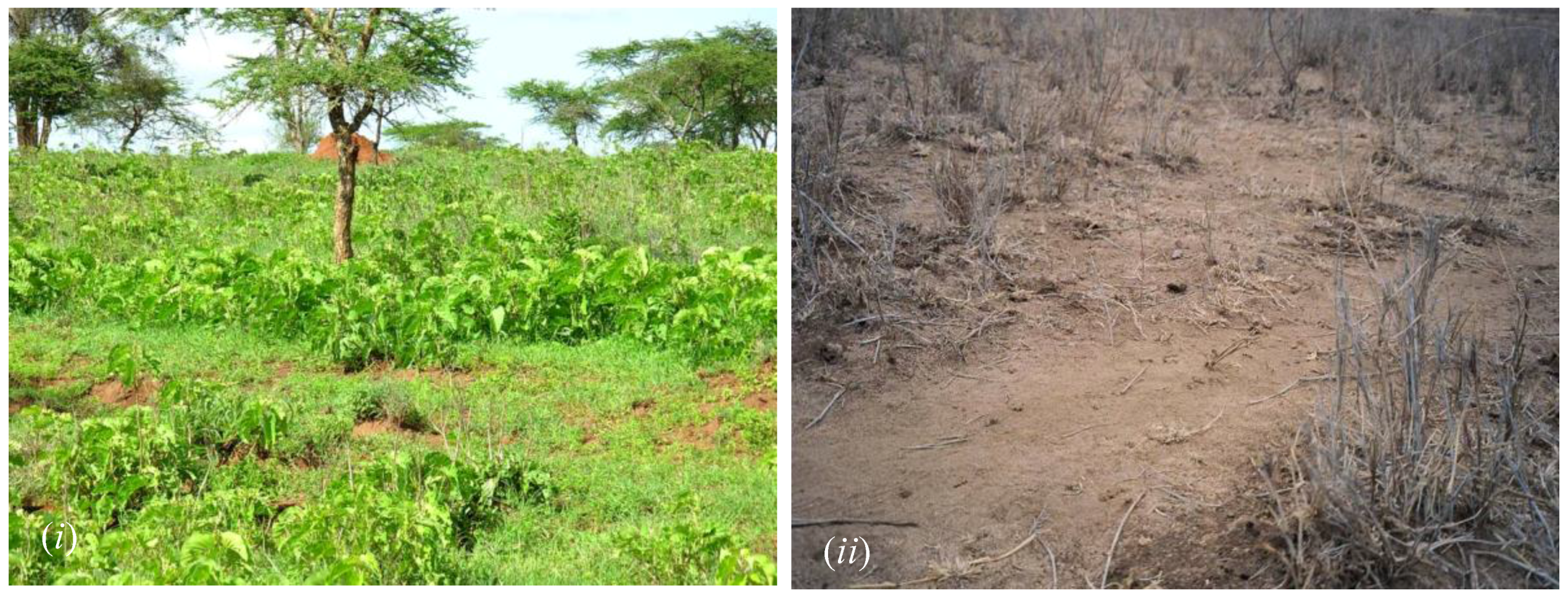
vis-à-vis the availability of CRR, the adaptive operation of the Maasai-pastoralism in this rangeland, and the consequent adaptive capacity of the Maasai to drought and to other non-drought factors. Like in similar ASALs, the occurrence of drought in the Maasai rangelands depletes grass and even defoliates some woody plants, thereby reducing vegetation density and foliage cover (Figure 5). From this study, it is evident that several drought events occurred across the region. The increased occurrences and/or intensity of droughts due to the changing climate [10,11] could exacerbate the magnitude with which vegetation density and foliage cover is altered. This could reduce the composition, abundance, recovery, and/or the productivity of certain plant forms and/or species, hamper rainfall infiltration capacity, and expose soil to agents of erosion, reducing soil fertility and altering the productivity of such environments.
In ecological terms, the evident manifestation of temporally clustered drought events reduces the availability of the already variable CRR that characterize this rangeland. The occurrence of consecutive droughts, particularly when they include an extreme drought, reduces vegetation density and its recovery, impairs establishment of pasture—for example, through the now-shortened growth season—and enfeebles the productive potential of the environment. Such droughts can also reduce the recharge and flow of water into the various water reservoirs, thereby occasioning water shortages for both human and livestock needs. It is pointed out that this impairment of environment productivity does not necessarily translate to the blighted function of other vital ecosystem attributes, as is the case with desertification [54]; they could remain unhindered since rangelands are highly resilient to various short-term disturbances.
In addition to these short-lived effects, the manifestation of recurrent droughts could cause long-lasting impacts, however. For example, consecutive drought events inhibit the continuous establishment of palatable natural grass and/or encourage invisibility of unpalatable plants (Figure 5) across spatial (e.g., from ecosystem to landscape level) and temporal scales (e.g., from ephemeral to long resident species/forms). Inhibited establishment of pasture in such spaces translates to the prolonged reduction of forage for the Maasai’s livestock, and the consequent reduction of yields from these animals, ultimately impairing households’ socioeconomic conditions. Existing studies shows that drought impacts on rangelands (e.g., depletion of pasture) translates to impaired productivity of these environments, which leads to insufficient nutritional supply for livestock [55,56], leading to impaired socioeconomics of the pastoralists. In sum, climatic-induced encroachment of invasive plants—and the alteration of forage cover and/or compositions of other species and/or forms— reduces the productivity of the Maasai’s livestock by encroaching upon the potential pasture spaces, thereby reducing the amount of forage that is extractable.
The deleterious effects of consecutive droughts, especially when they encompass an extreme drought, can also have a lasting deleterious impact on the socioeconomic status of a household, for example if a family loses most of or its entire herd of livestock because of the persistent shortage of pasture. These interpretations also suggest that the occurrence of consecutive droughts pre-exposes and hampers recovery of the ecological and the socioeconomic facets of the Maasai-pastoralism to the next drought event in the cluster. Clearly, drought has the capacity to occasion cascading and cumulative deleterious effects on the ecological and the socioeconomic facets of Maasai-pastoralism. Most importantly, these consecutive droughts occur against a backdrop of multiple livelihood risks—for example, conflicts, livestock and human disease, and water and pasture shortage—that regularly confront pastoralists across East Africa [6,22,24,39,40]. Therefore, consecutive droughts do not only hamper the ecological and socioeconomic recovery from the preceding drought event, but they also disrupt the viable operation of Maasai-pastoralism in the rangelands. This diminishes the adaptive capacity of the Maasai to drought hazard as well as to other livelihood risks. The manifestation of extreme and/or consecutive droughts suggests that these pastoralists are experiencing a threat to their very survival. Climate change–induced, intensified occurrence and the spatial extent of drought, (e.g., [10,11,52]) will reinforce the manifestation of these conditions and happenings.
The evident differential spatial coverage of drought spaces (Figure 3 and Figure 4) is a plausible indicator of the intensity with which pasture is depleted. It should be noted that the intensity of drought does not necessarily equal the consequent rate of forage depletion. Existing studies have shown that, in the rangelands, variability in annual vegetation production is ca. 50% higher than corresponding variability in annual rainfall on locations receiving less than 600 mm [57]. Given this, and given that the dynamics of pasture within the ASALs strongly track the trends of precipitation [58] and that much of what Kajiado receives is on the rims of this amount, is it plausible that a meteorological drought of moderate intensity is environmentally and hence socioeconomically devastative on Maasai-pastoralism and similar livelihoods in these rangelands than would be projected via occurrence of meteorological drought alone? The differential coverage by drought suggests that different drought events occasion divergent impacts. The evident irregular mosaics of these drought spaces across timescales indicate the shifted intensity of droughts, and provide clues about the availability of pasture. It specifically indicates the shifted heterogeneity of pasture across timescales and the differential shortage of this critical land resource during periods of drought.
For example, the evident patches of the persistently mild to no-drought (ca. −0.5–0.0) condition around Mount Kilimanjaro and the Namanga Hills (Figure 3) indicate areas where pasture and other vegetation forms are unaffected, or mildly affected, by drought. Drought intensities tracked agroecological zones—high-potential zones such as around Mount Kilimanjaro experience mild to low-intensity drought, mainly normal drought from the Maasai’s perspective, and vice versa for low-potential zones such as Magadi—translate to variable availability or depletion of CRR.
The evident manifestation of intense drought conditions in areas of low agroecological potential (e.g., Magadi) and vice versa for higher agroecological spaces (e.g., around the Chyulu Hills and Mount Kilimanjaro) (Figure 3), respectively, indicate the plausible shortage of CRR, particularly forage, or its availability thereof. It is pointed out that the availability of CRR does not translate into its accessibility: much of these spaces are privately owned and under protected and fortressed wildlife sanctuaries [6], and therefore have higher odds of inaccessibility for the Maasai’s livestock.
Apropos variable availability or depletion of CRR, and ceteris paribus, because high-potential zones harbor more leafy woody species than low-potential zones, it translates to the persistent availability of browse forage for the Maasai’s browsing livestock (mainly goats); therefore, a household rearing more goats than cattle or sheep (grazers) will be able to exploit such spaces during periods of drought. Thus, rearing goats in these rangelands enhance one’s adaptive capacity. Moreover, the former livestock species has higher odds of thriving even under drought condition because graminoids deplete at a faster rate than woody species (both trees and shrubs), and because goats are more adapted to drylands than the current breeds of the Maasai’s cattle and sheep: a situation explaining why cattle and sheep register high mortality during periods of drought [6]. The converse applies for areas of persistent patches of intense drought, for example within Magadi. The manifestation of these mosaics of drought spaces further confirms the diversity of ecoclimatic zones in this rangeland. The projected intensified occurrence and spatial coverage of drought alongside proliferation of aridity [9,10,11] could expand the extent of the currently arid and semi-arid spaces and reduce the extent of the present transitional semi-humid–semi-arid agroecological zones, and plausibly diminish the humid spaces altogether. This, collectively, could lead to reduced heterogeneity of critical land resources that characterize this rangeland and occasion widespread and simultaneous shortage of forage for the Maasai’s livestock across scales. Note that this manifests against a backdrop of reducing the spatial extent of pastoral land due to the permeation of pressures from socioeconomic globalization, for example agriculture encroachment, access-restricted wildlife sanctuaries, and land privatization (
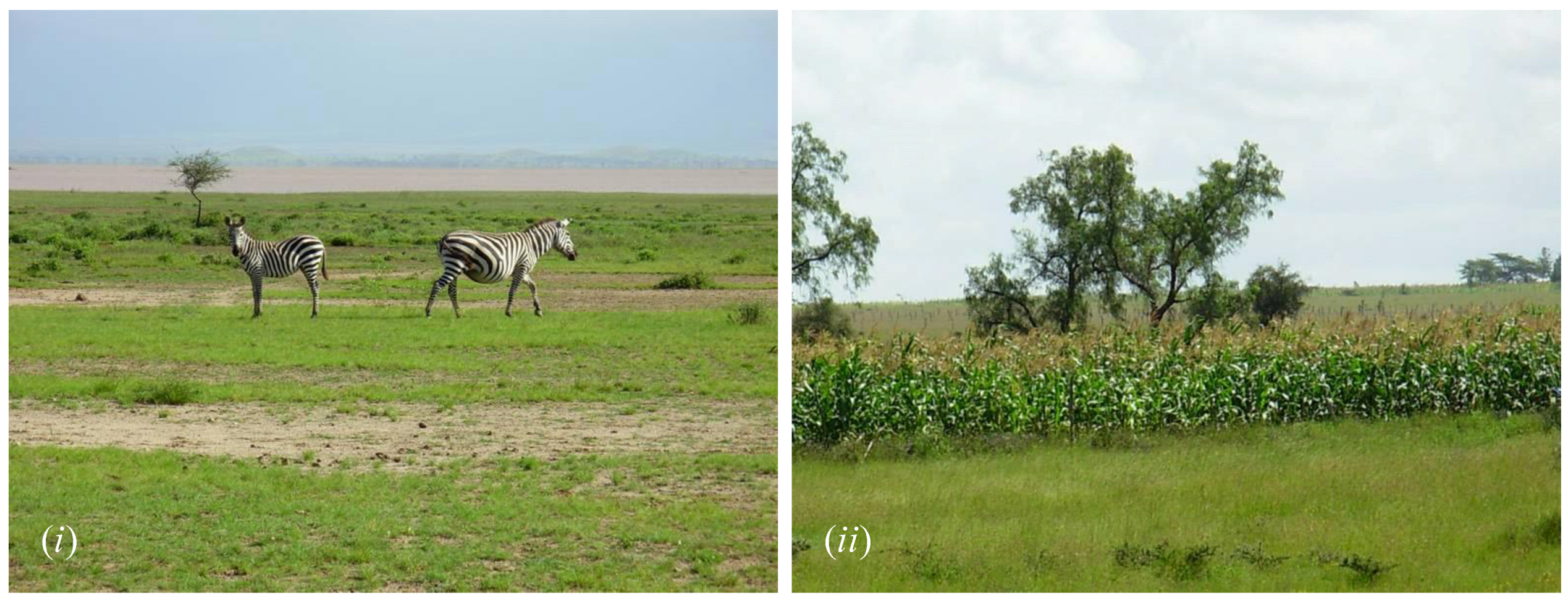
Figure 6), on the present ASAL zones of the Maasai land. In fact, over 40% of the land area under the semi-arid agroecological zone was lost to agriculture encroachment alone between the 1970s and the 1990s across the pastoral districts of Kenya [7], which include all the country’s Maasai land.
These land-use types were carved out of formerly communal Maasai land, a situation that has been occasioned by shifts in land tenure and the subsequent sub-division of lands. Tenurial changes are traceable in policies and programs of the British colonial authority, of the post-colonial government of Kenya, and of the collaborative efforts of Kenya’s administration and development agencies that operate under the aegis of the various bilateral and multilateral partnerships, in that order, over temporal scale, which altered land tenure to start with [16,59,60,61]. In addition, data from the wider project revealed that the sale of some of the Maasai’s lands to private users, both Maasai and non-Maasais [6]. This is an undertaking that serves to reinforce changes in the land tenure systems, with an overall loss of tracts of Maasai land, and by extension, a loss of access to the various CRR contained therein. Taken together, the findings of this study suggest that drought is only partially influential in dictating the availability of CRR among the Maasai in the rangelands of southern Kenya, and that simultaneous alteration by cross-scale social, climatic, and environmental factors dictates the availability of CRR, the adaptive operation of Maasai-pastoralism, and, ultimately, the drought-adaptive capacity of these pastoralists. Thus, it is clear that availability and accessibility of CRR is simultaneously influenced by drought and human and environmental factors.
From a drought adaptation and ASAL resource management perspective, locations that are persistently unaffected by this climatic hazard are indicative of spaces that harbor dependable sources of forage during periods of drought in Kajiado; and, if accessible, such spaces can offer refuge for the Maasai’s livestock during periods of drought. From a policy perspective, initiatives for practical alleviation of pasture shortage toward enhanced adaptive capacity of the Maasai should be hinged upon an understanding of the multiple and cross-scale challenges of accessing these climatically and ecologically spatiotemporally diverse spaces that contain CRR. Therefore, the need for mainstreaming drought adaptation into land-use policies cannot be overemphasized.

5. Conclusions, Emerging Themes, and Recommendations

The empirical evidence of the current study reveals that drought occurrences in Kajiado have been recurrent, widespread, variously cyclic, sometimes temporally clustered, and manifested with varying intensities across spatial, temporal, and, occasionally, social scales. An estimated 86% of drought occurrences in this rangeland, over the last three decades alone, were of the major drought category. The 1990s and 2000s recorded four major drought events; the latter include two extreme droughts, and the former include one. A strong consensus exists among the Maasai regarding observed drought events. The findings also reveal that no two droughts are alike: there are inter- and intra-event variations and whether this has significant implications vis-à-vis the type of impacts and adaptations need be established. The current results also reveal that drought occurrence and its perception is as much a constructed and existing condition as it is a meteorologically and socioeconomically generated one. It is also evident that drought as perceived through the lens of Maasai pastoralists is simultaneously multivariate and multiscalar. The inherent simultaneous multivariate and scalar nature of the pastoralist drought distinguishes it from the conventional drought types, particularly the meteorological droughts that predominantly guide drought and resource management in the rangelands of Kenya. From a policy perspective, monitoring drought as it evolves can reveal the condition of the CRR, particularly pasture, and by extension, the condition of adaptive resource extraction, for example herding destinations of the Maasai. The findings reveal that knowledge about drought affects the way this climatic hazard is perceived, communicated, and characterized. In these rangelands, drought manifests with more intensity in lower than higher agroecological regions.
Overall, drought occurrences in the Maasai rangelands of Kenya portray indistinct spatiotemporal annual trends, and their occurrences are more discernible at finer-resolution spatial scales and over shorter timescales. The findings suggest that drought occurrence in this region differentially affects CRR, and manifests with varying cross-scale ripple influences on the ecological and socioeconomics facets that structure Maasai-pastoralism. The nature of the adaptive capacity of and resource management in indigenous Maasai-pastoralism across these rangelands of Kenya is, ceteris paribus, strongly hinged on how drought is perceived, communicated, and characterized alongside its spatiotemporal distribution. Taken together, the current findings reveal that the occurrence of a meteorological drought is only partially influential in defining the state of the drought-adaptive capacity of the Maasai. The pastoralist drought suggests that simultaneous alterations by cross-scale social and biophysical factors, their processes, and their diverse interactions shape resource management and drought-adaptive capacity in Maasai-pastoralism.
The observed recurrence, vastness, cyclic pattern, and temporal clustering of drought hamper the adaptive operation of Maasai-pastoralism, and therefore constitute a challenge which the Maasai must face continuously. Interventions that seek to enhance the adaptive operation of Maasai-pastoralism in the region should account for the cross-scale climatic conditions, and should seek first to understand how the various facets of this livelihood interact with drought. The need to engage the locals and the use of multiple sources of data in the assessments of Maasais drought-adaptive capacity, therefore, cannot be overemphasized. The current findings suggest that the geography of resource management in Maasai-pastoralism is being altered as drought occurrence increases and as the climate continues to change. Thus far, given the coarseness and the uncertainties of the existing climate models, how climatic/meteorological drought will manifest at the finer-resolution scales across the ASALs of Africa in the future of the changing climate is still an on-going quest—and those of pastoralist drought remain speculative. In the interim, the need for informed, proactive drought adaptations amidst the multiple cross-scale social factors, particularly the drivers of socioeconomic globalization, cannot be overemphasized: this should be the focus of future studies.

Acknowledgments

Special thanks to the Maasai community of Kenya, East Africa, for their continued willingness to share their wealth of knowledge with me. Thanks to three geographers—Alan Taylor, Karl Zimmerer and the late C. Gregory Knight—for valuable discussions in the early framing of research arguments. Alan Taylor, thank you for challenging me to explore diverse meanings of drought vis-à-vis the system of Maasai-pastoralism: this article is the fruit of that exploration. Special thanks to The International Foundation for Sciences, United Nations University, PennState’s Earth and Environmental Systems Institute, and Miombo Network for providing partial financial and logistic support for the broader projects that informed this work. Comments by three anonymous reviewers have helped improve this work, and are greatly appreciated. The author’s affiliation—Department of Geography, The Pennsylvania State University—is based on where the work was developed and conducted under project # 21118; and utmost appreciation is registered.

Conflicts of Interest

The authors declare no conflict of interest.

References

  1. Emergency Events Database: Country Profiles. Available online: http://www.emdat.be (accessed on 25 January 2015).
  2. Famine Early Warning Systems Network. Available online: Http://www.fews.net (accessed on 11 December 2015).
  3. United Nations Integrated Regional Information Networks (IRIN). Drought-Related Deaths in the Northeast. Available online: http://www.irinnews.org/news/2005/12/22/drought-related-deaths-northeast (accessed on 6 March 2005).
  4. United Nations Integrated Regional Information Networks (IRIN). Massive Crop Failure in “Grain Basket”. Available online: http://www.irinnews.org/report/85788/kenya-massive-crop-failure-grain-basket (accessed on 11 April 2009).
  5. United Nations Integrated Regional Information Networks (IRIN). Ready or Not—Drought Tests Ethiopia. Available online: http://www.irinnews.org/report/102249/cop-21-ready-or-not-drought-tests-ethiopia (accessed on 25 January 2015).
  6. Mwangi, M. Effects of Drought on Nomadic Pastoralism: Impacts and Adaptation among the Maasai of Kajiado District, Kenya. Ph.D. Thesis, The Pennsylvania State University, University Park, PA, USA, 2012. [Google Scholar]
  7. UNEP-GoK. Environmental Assessment of Drought; United Nations Environmental Programme (UNEP) and the Government of Kenya (GoK): Nairobi, Kenya, 2005.
  8. Millennium Ecosystem Assessment: Strengthening Capacity to Manage Ecosystems Sustainably for Human Well-Being. Available online: http://www.millenniumassessment.org (accessed on 6 March 2005).
  9. IPCC. Climate Change 2001: Impacts, Adaptation and Vulnerability, Intergovernmental Panel on Climate Change—Third Assessment Report; Cambridge University Press: Cambridge, UK, 2001. [Google Scholar]
  10. IPCC. Climate Change 2007: Impacts, Adaptation and Vulnerability, Intergovernmental Panel on Climate Change—Fourth Assessment Report; Cambridge University Press: Cambridge, UK, 2007. [Google Scholar]
  11. IPCC. Climate Change 2014: Impacts, Adaptation and Vulnerability, Intergovernmental Panel on Climate Change—Fifth Assessment Report; Cambridge University Press: Cambridge, UK, 2014. [Google Scholar]
  12. Sivakumar, M.V.K.; Das, H.P.; Brunini, O. Impacts of present and future climate variability and change on agriculture and forestry in the arid and semi-arid Tropics. Clim. Change 2005, 70, 31–72. [Google Scholar] [CrossRef]
  13. Brooks, N.; Adger, W.N.; Kelly, P.M. The determinants of vulnerability and adaptive capacity at the national level and the implications for adaptation. Glob. Environ. Change 2005, 15, 151–163. [Google Scholar] [CrossRef]
  14. Wilhite, D.A. 2000 Drought as a natural hazard: Concepts and definitions. In Drought: A Global Assessment; Routledge: London, UK; pp. 3–18.
  15. Government of Kenya. District Development Plan: Kajiado; Government Printer: Nairobi, Kenya, 1994.
  16. Government of Kenya. District Development Plan: Kajiado; Government Printer: Nairobi, Kenya, 2002.
  17. Katampoi, K.; Ole Genga, G.O.; Mwangi, M.; Kipkan, J.; Ole Seitah, J.; van Klinken, M.K.; Mwangi, M.S. Kajiado District Atlas; Ministry of Reclamation and Development of Arid, Semi-Arid Areas and Wastelands, Government of Kenya (GoK): Nairobi, Kenya, 1990.
  18. Government of Kenya. District Development Plan: Kajiado; Government Printer: Nairobi, Kenya, 1997.
  19. Jaetzold, R.; Schmidt, H. Farm Management Handbook of Kenya; Ministry of Agriculture: Nairobi, Kenya, 1983.
  20. Georgiadis, N.J. Microhabitat variation in an African savanna: Effects of woody cover and herbivores in Kenya. J. Trop. Ecol. 1989, 5, 93–108. [Google Scholar] [CrossRef]
  21. Stevens, J. Applied Multivariate Statistics for the Social Sciences; Lawrence Erlbaum Associates: Hillsdale, NJ, USA, 1986. [Google Scholar]
  22. Mwangi, M. Effects of drought on nomadic pastoralism: Impacts and adaptation among the Maasai of Kenya. In Proceedings of the Global Environmental Change, Globalization and International Security: New Challenges for the 21st Century, Bonn, Germany, 9–13 October 2005.
  23. Mwangi, M. Effects of livelihood-diversification on sustainability of natural resources in the rangelands of East Africa: Participatory field studies and results of an agent-based model using the knowledge of indigenous Maasai pastoralists of Kenya. In Environmental Modeling with Stakeholders; Gray, S., Jordan, R., Gray, S., Eds.; Springer: New York NY, USA, in press.
  24. Mwangi, M. Gender and drought hazards in the rangelands of the Great Horn of Africa: Is gender equity the only solution? Women Environ. Int. 2007, 74, 21–24. [Google Scholar]
  25. Edwards, D.C.; McKee, T.B. Characteristics of 20th Century Drought in the United States at Multiple Time Scales; Colorado State University: Fort Collins, CO, USA, 1997. [Google Scholar]
  26. Hayes, M.J.; Svoboda, M.D.; Wilhite, D.A.; Vanyarkho, O.V. Monitoring the 1996 drought using the standardized precipitation index. Bull. Am. Meteorol. Soc. 1999, 80, 429–438. [Google Scholar] [CrossRef]
  27. Chilès, J.P.; Delfiner, P. Geostatistics: Modelling Spatial Uncertainty, 1st ed.; Wiley-Interscience: New York, NY, USA, 1999. [Google Scholar]
  28. Goovaerts, P. Geostatistical approaches for incorporating elevation into the spatial interpolation of rainfall. J. Hydrol. 2000, 228, 113–129. [Google Scholar] [CrossRef]
  29. Goovaerts, P. Geostatistics for Natural Resources Evaluation; Oxford University Press: New York, NY, USA, 1997. [Google Scholar]
  30. Moral, F.J. Comparison of different geostatistical approaches to map climate variables: Application to precipitation. Int. J. Climatol. 2010, 30, 620–631. [Google Scholar] [CrossRef]
  31. Webster, R.; Oliver, M.A. Geostatistics for Environmental Scientists, 2nd ed.; John Wiley & Sons: Chichester, UK, 2007. [Google Scholar]
  32. Cressie, N. Statistics for Spatial Data, 1st ed.; Wiley: New York, NY, USA, 1991. [Google Scholar]
  33. Diodato, N. The influence of topographic co-variables on the spatial variability of precipitation over small regions of complex terrain. Int. J. Climatol. 2005, 25, 351–363. [Google Scholar] [CrossRef]
  34. Lloyd, C.D. Assessing the effect of integrating elevation data into the estimation of monthly precipitation in Great Britain. J. Hydrol. 2005, 308, 128–150. [Google Scholar] [CrossRef]
  35. Nalder, I.A.; Wein, R.W. Spatial interpolation of climatic normals: Test of a new method in the Canadian boreal forest. Agric. For. Meteorol. 1998, 92, 211–225. [Google Scholar] [CrossRef]
  36. Phillips, D.L.; Dolph, J.; Marks, D. A comparison of geostatistical procedures for spatial analysis of precipitation in mountainous terrain. Agric. For. Meteorol. 1992, 58, 119–141. [Google Scholar] [CrossRef]
  37. Tabios, G.Q.; Salas, J.D. A comparative analysis of techniques for spatial interpolation of precipitation. Water Resour. Bull. 1985, 21, 365–380. [Google Scholar] [CrossRef]
  38. Food and Agriculture Organization. The Community’s Toolbox: The Idea, Methods and Tools for Participatory Assessment, Monitoring and Evaluation in Community Forestry. 1990. Available online: http://www.fao.org (accessed on 6 March 2009).
  39. Quinn, C.H.; Huby, M.; Kiwasila, H.; Lovett, J.C. Local perceptions of risk to livelihood in semi-arid Tanzania. J. Environ. Manag. 2003, 68, 111–119. [Google Scholar] [CrossRef]
  40. Smith, K.; Barrett, C.B.; Box, P.W. Participatory risk mapping for targeting research and assistance: With an example from East African Pastoralist. World Dev. 2000, 28, 1945–1959. [Google Scholar] [CrossRef]
  41. Adger, W.N.; Kelly, P.M. Social vulnerability to climate change and the architecture of entitlements. Mitig. Adapt. Strateg. Glob. Change 1999, 4, 253–266. [Google Scholar] [CrossRef]
  42. Kelly, P.M.; Adger, W.N. Theory and practice in assessing vulnerability to climate change and facilitating adaptation. Clim. Change 2000, 47, 325–352. [Google Scholar] [CrossRef]
  43. Little, P.; Smith, K.; Cellarius, B.A.; Coppock, D.L.; Barrett, C.B. Avoiding disaster: Diversification and risk management among East African herders. Dev. Change 2001, 32, 387–419. [Google Scholar] [CrossRef]
  44. Little, P.D. Pastoralism, biodiversity, and the shaping of savanna landscapes in East Africa. J. Int. Africa Inst. 1996, 66, 37–51. [Google Scholar] [CrossRef]
  45. Ogallo, L.A.; Janowiak, J.E.; Halpert, M.S. Teleconnection between seasonal rainfall over East Africa and global sea surface temperature anomalies. J. Meteorol. Jpn. 1988, 66, 807–821. [Google Scholar]
  46. Ntale, H.K.; Gan, T.Y. East African rainfall anomaly patterns in association with El Niño/Southern Oscillation. J. Hydrol. Eng. ASCE 2004, 9, 257–268. [Google Scholar] [CrossRef]
  47. Ogallo, L.A. Validity of the ENSO-related impacts in eastern and southern Africa. In Usable Science: Food Security, Early Warning, and El Niño; University of Nairobi: Budapest, Hungary, 1993; pp. 179–184. [Google Scholar]
  48. World Meteorological Organization. Available online: www.wmo.int (accessed on 14 February 2016).
  49. Luseno, W.K.; McPeak, J.G.; Barrett, C.B.; Little, P.D.; Gebru, G. Assessing the value of climate forecast information for pastoralists: Evidence from southern Ethiopia and Northern Kenya. World Dev. 2003, 31, 1477–1494. [Google Scholar] [CrossRef]
  50. Gibbs, W.J. Drought—Its Definition, Delineation and Effects; World Meteorological Organization: Geneva, Switzerland, 1975; p. 113. [Google Scholar]
  51. Subrahmanyam, V.P. Incidence and Spread of Continental Drought: World Meteorological Organization, International Hydrological Decade; WMO: Geneva, Switzerland, 1967. [Google Scholar]
  52. Murphy, C.; Tembo, M. Observed and Projected Climate Change in the Philippines, Honduras, Kenya, Malawi and Ethiopia; Trócaire: Maynooth, Ireland, 2015. [Google Scholar]
  53. Bassett, T.J. The political ecology of peasant-herder conflicts in the Northern Ivory Coast. Ann. Assoc. Am. Geogr. 1988, 78, 453–72. [Google Scholar] [CrossRef]
  54. Archer, S.; Boutton, T.W.; Hibbard, K.A. Trees in grasslands: Biogeochemical consequences of woody plant expansion. In Global Biogeochemical Cycles in the Climate System; Schulze, E.-D., Harrison, S.P., Heimann, M., Holland, E.A., Lloyd, J., Prentice, I.C., Schimel, D., Eds.; Academic Press: San Diego, CA, USA, 2001; pp. 115–137. [Google Scholar]
  55. Coppock, D.L.; Reed, J.D. Cultivated and Native browse legumes as calf supplements in Ethiopia. J. Range Manag. 1992, 45, 231–238. [Google Scholar] [CrossRef]
  56. Oba, G. The effect of multiple droughts on cattle in Obbu, Northern Kenya. J. Arid Environ. 2001, 49, 375–386. [Google Scholar] [CrossRef]
  57. Le Houérou, H.N.; Bingham, R.L.; Skerbek, W. Relationship between the variability of primary production and the variability of annual precipitation in world arid lands. J. Arid Environ. 1988, 15, 1–18. [Google Scholar]
  58. Ellis, J.; Galvin, K. Climate patterns and landuse practices in the dry zones of Africa. BioScience 1994, 44, 340–49. [Google Scholar] [CrossRef]
  59. African Land Development Board. Land Development in Kenya: Report; Ministry of Agriculture and Animal Husbandry: Nairobi, Kenya, 1962.
  60. Sindiga, I. Land and population problems in Kajiado and Narok, Kenya. Afr. Stud. Rev. 1984, 27, 23–39. [Google Scholar] [CrossRef]
  61. Western, D.; (Kenya Wildlife Service (KWS), Nairobi, Kenya). Personal communication, 2007.
Figure 1. Kajiado District, Kenya, showing six the administrative divisions. * Central Division has since been sub-divided. Inset: Map of Kenya and Africa showing the location of Kajiado in the context of the broader region.
Climate 04 00022 g001
Figure 2. (a) Annual drought/rainfall trend for Kajiado based on standardized index. The region bounded by values (−1)–(+1) denotes the normal condition, while above and below it, respectively, symbolize a wet, flooded situation and dry, extreme drought conditions. Contrast: temporal = p < 0.05, spatial = p < 0.01. (b) Chronicles of drought occurrences for Kajiado District (N = 176). This sample was drawn from documented events from diverse publications and datasets (print mass media, grey literature, and academic/scholarly). * Drought events/decade. Pre-1960s records are scant and scattered; post-1960 records are complete and widely available. Consecutive drought events (years, with sets where applicable): 1880–1899 (five), 1900–1919 (seven), 1920–1929 (zero), 1930–1939 (two, three), 1940–1949 (three, four), 1950–1959 (six, two), 1960–1969 (two), 1970–1979 (two, four), 1980–1989 (six), 1990–1999 (two, two), 2000–2009 (two, two, two), 2010–2015 (two, two). Drought attributed to poor/failed rains (56%, N = 176, p < 0.01) or poor/failed seasonal rains (28%, N = 176, p < 0.05); source contrast (non-scholarly > scholarly): p < 0.0001.
Climate 04 00022 g002aClimate 04 00022 g002b
Figure 3. Drought intensity across spatial scales based on standardized drought index using rainfall station data. Namanga Hills are the Ol Doinyo Orok and Lemilebru-Ingito Hills. CH = Chyulu Hills. The progression of color from dark hue (high values, ca. (−0.5)–(0.0) e.g., 0 around Mount Kilimanjaro) to light shade (low values, ca. (−0.6)–(−5.0)), e.g., −5.0 around Magadi) symbolize intensity of drought from normal range to severe/extreme conditions, respectively. Av = annual average, and Lr = long-rains average. Contrast: temporal = p < 0.05, spatial = p < 0.0001.
Climate 04 00022 g003
Figure 4. Annual trend of drought occurrence in Kajiado based on emic survey data. Dotted line denotes the border between frequent and infrequent mentioning. Scaled-Importance-value (Sv): 1 = minor, 3 = extreme. Contrast: temporal = spatial = p < 0.01.
Climate 04 00022 g004
Figure 5. Vegetation of differing palatability at the ecosystem-scale (finer spatial scale) in Namanga Division. (i) = high coverage of unpalatable lush C3-herbaceous than of palatable C4-grass during rainy season in 2007; (ii) = dry fibrous C4-grass at the height of an extreme drought in 2005. Photo Credit: Margaret Mwangi.
Climate 04 00022 g005
Figure 6. Portraits of land-use change, and loss of Maasai land, in the southern rangelands of Kenya. (i) = Zebra in Amboseli National Park (Lake Amboseli is captured in the background), in Loitokitok Division; and (ii) = Maize (Zea mays) field in Central Division. Photo Credit: Margaret Mwangi.
Climate 04 00022 g006
Table 1. Emic accounts on factors indicating occurrence of drought based on the Maasai’s perspectives.
Drought components in Maasai-pastoralism, N=120
Variables indicating drought£Respondents (Pv%)§
(1)delayed/early-termination of seasonal rains30.4a
(2)reduced spatial extent of seasonal rains7.3b
(3)failure of seasonal rains100a
(4)failure of long-rains14a
(5)failure of two consecutive seasonal rains18.7a
(6)intense aridity during the dry-season25.0b
(7)shortage of pasture (grass)100a
(8)both shortage of pasture and water86b
(9)any of 1–6 (above) plus pasture-shortage100c
(10)failure of rains & 8 (above) & soil desiccation & depletion of forage68c
(11)9 (above) & declined cattle-productivity100a
(12)9 (above) & declined livestock-productivity77b
(13)continual household's inability to purchase livestock-input & food52c
(14)monotonous/lack of vegetables in markets61c
(15)failure of crops in farmers' fields34a
§ Total proportion (Pv%) is greater than 100% because of multiple responses. Superscripts indicate rank of the factor in terms of its Scaled-Importance-value (Sv): a = 2.45–3.00, >80%, mode-Sv 91%) = high, b = 1.45–2.44, >48<80%, mode-Sv 65%) = moderate, c = 1.00–1.44, >33≤48%, mode-Sv 41%) = low. £ Long-rains, short-rains, and the dry-season (also referred to as the drizzling season) are called Nkokua, Oltumuret, and Oloirurujuruj respectively.

