1. Introduction
This paper concerns the growth of urban settlements as they merge over time to form a single conurbation, and the changes they undergo, as can be revealed by a configurational approach. Attention is mainly focused on the distribution of traffic flows, whose pattern is strongly influenced by the merging of the pre-existing grids into a unique road network. The matter of resilience will also be evoked, in order to discuss the way the making of a conurbation can modify the capability of an urban system to adsorb accidental events and transformations without significantly changing its global behavior.
The specific case of Florence is more than a case study; it is a paradigmatic example of the suburban sprawl of an urban settlement, useful for describing how it changes as it merges with the surrounding settlements and for discussing the effects of the conurbation on its original inner geography.
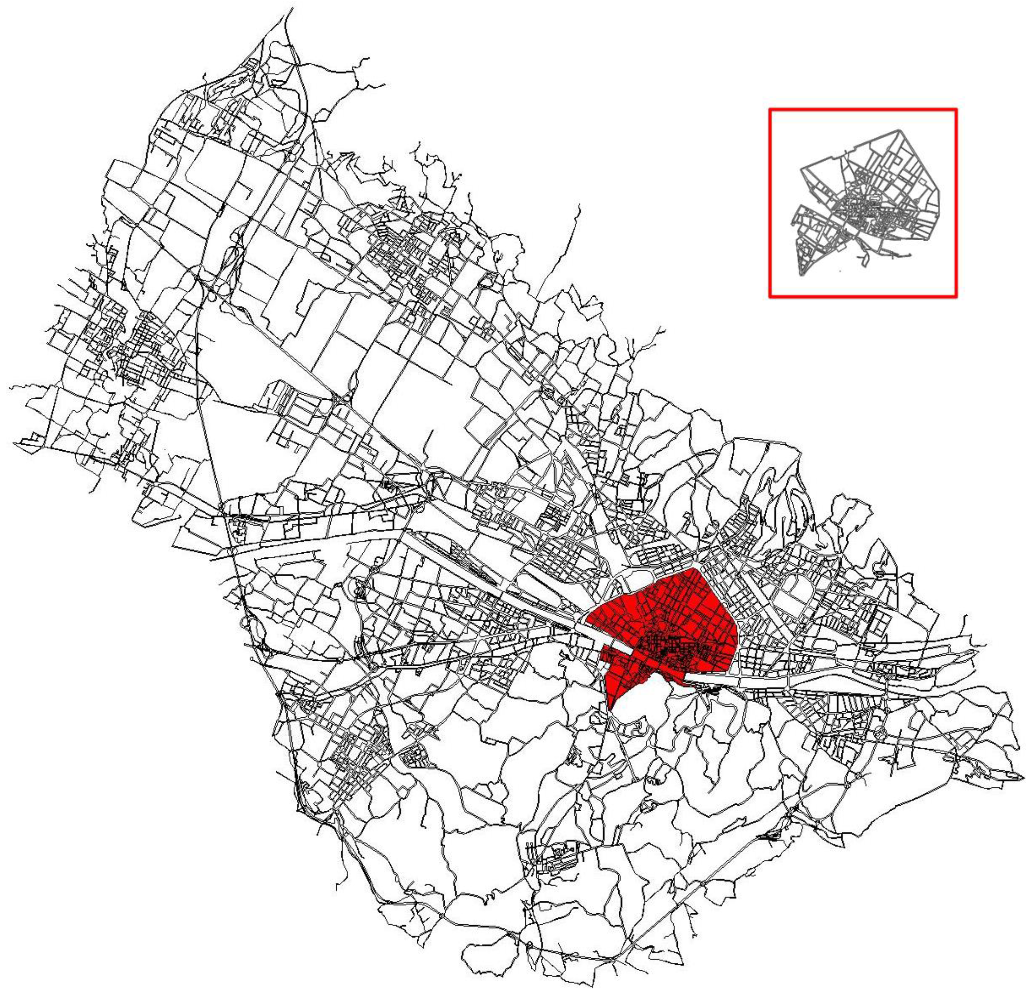
The urban growth of Florence, constrained by the presence of steep hills on its southern and eastern sides, has been mainly oriented northward since the middle of the 20th century. This has determined the progressive urbanization of the so-called
piana fiorentina (literally “Florentine plain”), the wide flatland generated by the middle reaches of the River Arno, thus including and binding together within a unique conurbation a number of pre-existing nuclei, namely Calenzano, Campi Bisenzio, Lastra a Signa, Sesto Fiorentino, and Signa, up to the edges of Prato and Pistoia, as shown in
Figure 1.
Over time, urban congestion and the poor vehicular accessibility of the ancient inner core have caused more and more prominent activities to shift towards this wide developing area, which—just to give an idea—now houses the administrative departments of the Regione Toscana, the Careggi Hospital of Florence, the Penal and Civil Court, several departments of the University of Florence, and the airport of Florence, besides some huge shopping centers, hypermarkets, and department stores. As a result of such a dense concentration of activities, the Florentine plain can now be easily acknowledged as one of the most attractive parts of the whole settlement, counterbalancing the traditional representativeness and touristic attractiveness of the historic center of Florence, as well as the evocative strength it holds in the collective imagination.
This northwestern growth and the decentralization of Florentine activities were not accompanied by a global infrastructure development, nor was an efficient public transport system ever provided to connect the new development areas to the pre-existing urban core, due to the administrative fragmentation of the whole settlement. The Florentine conurbation actually overlaps the territories of 11 municipalities, obviously including Florence itself. Without efficient road connections, most of the urban vehicular movement to and from the northwestern areas uses the national motorway, A1, which touches Florence on its western side. In other words, the toll motorway A1, the so-called Autostrada del Sole (literally, Motorway of the Sun), which connects Naples and Milan via Rome, Florence, and Bologna—thus representing the spinal cord of the Italian road network as well as the most used and crowded national motorway—as it approaches the Florence conurbation assumes a dual function, since the significant local use is on top of the heavy road traffic running down the Italian peninsula. This is obviously a serious problem, in that local movement strongly contributes to the already intense car traffic, whose average daily volume is well over 80,000 vehicles. Moreover (but by no means a secondary issue) the motorway deprives the city of the economic benefits of a significant part of urban through movement, which is shifted from built areas towards an extra-urban toll road, closed to bikes and pedestrians.
A configurational approach will here be used to analyze the relationship between movement and urban structure, in order to investigate how the movement pattern has changed over time as a result of the growth of the conurbation and according to the progressive transformation of its grid. Such analysis is expected to provide some significant information on the shifting of the distribution of movement flows; it will also pinpoint the role the motorway is likely to play within the present pattern of urban vehicular movement. More generally, the use of a configurational approach is expected to capture the influence of the urban grid in the distribution of movement flows, thus bridging the gap between urban design, focused on the morphologic features of blocks and buildings, and transport analysis, strictly concerned with the distribution of movement flows on the street network.
2. Backwards
As hinted above, the subject of this paper deals with two main issues, here interwoven. The first issue is the growth of an urban settlement, which sprawls over time so as to form a conurbation, merging and binding together several pre-existing urban nuclei. The genesis of the conurbation involves the distortion of the centrality of the original nuclei and its shifting towards new central areas; the movement pattern is also strongly affected by these changes, generating a different distribution of traffic flows. The second issue is the matter of vehicular traffic in towns, the benefits and the problems it brings to urban settlements; in the observed case study of Florence, such an issue is exacerbated by the presence of the A1 motorway, which is also used for local movement. The issues of urban morphology and dynamics, on the one hand, and traffic distribution, although closely intertwined, are generally addressed and approached from different points of view, as a result of a disciplinary division entrusted by a long-lasting traditional split.
The matter of the split between the treatment of roads as traffic channels and their assumption as streets—composing the public space of a settlement, available for different uses, and narrowly connected with blocks and buildings—has already been deeply investigated. The question of vehicular traffic in towns is in fact as old as the hills, dating back to the middle of the 20th century, when the increase of car traffic imposed the need for solutions suitable for making the presence of vehicles compatible with buildings, pedestrians, and urban life. The key idea of Modern Movement, explicit in the Athens Charter and destined to widely affect town planning in the decades to come, was to split buildings and roads, liberating their own forms from each other, providing urban roads with the unique role of circulation route and thus hierarchically classifying them with reference to traffic flow and road capacity. It is worth remembering that the split between urban roads and buildings necessarily involves the removal of traffic away from the building fronts, and hence the extinction of the street as intended so far: “il faut tuer la rue-corridor” [
1] is the well-known battle cry of such a position.
Setting aside its effect on architecture and urban morphology, such a traffic-driven approach was equated to a “cataclysm” [
2], or even a real schism, definitely partitioning the two fields of traffic engineering and street (urban) design [
3]. Since the middle of the 20th century, the main focus on the matter of vehicular traffic suggested the severe distinction between roads for traffic and paths providing access to buildings as well as their classification as “entirely different and mutually antagonistic” [
4] (p. 297), a prelude to the subsequent hierarchical classification of urban roads by the Buchanan Report: “basically, there are only two kinds of roads—distributors designed for movement, and access roads to serve the buildings” [
5] (p. 44). Such a distinction hence involved the assumption of ‘traffic conduits’ as incompatible with the urban fabric and preventing them from approaching and giving access to buildings [
4]; Oxford Street, London, is here cited as a very bad example of dangerous promiscuity, with the result that, “on average, one pedestrian is injured by the traffic every shopping day” [
4] (p. 297). The division between ‘urban corridors’ and ‘urban rooms’, represented by the metaphor of the hospital, whose departments are individually accessible and cannot be affected by through routes [
5], as well as the paradigmatic planning of Radburn, in New Jersey, is well suited to represent this method, whose basic rule is to facilitate origin–destination movement and to repel through-traffic: “shopping, business and residential areas must be kept quite separate from all arterial and sub-arterial roads, and confined to local roads (…); the layout of systems of local roads must be such as will afford no short-cuts to through-traffic” [
4] (p. 310). On the whole, the result is what was said to be “a division of traffic and towns into separate areas of priorities” [
3] (p. 48).
Relevant and recurring criticisms have long been raised against such approach milestones, among others, Jane Jacobs and Christopher Alexander—mainly complaining about the impoverishment of the streets it involves, the weakening of social life, and the shifting of accessibility from the historic center towards the periphery [
6,
7]; however, the split between movement and urban space has gone leaving its mark, easy to recognize both in the street network and in the spatial configuration of most cities. As a play on words shrewdly synthesized [
8], transport appears to play a double role, having been both the maker of cities—as the primary reason of their origin—as well as their breaker—as the recent cause of their sprawl. Nowadays questions concerning the road network and the accessibility of places and activities are mainly considered mere infrastructural issues and a specific matter for traffic engineers, or, as it was said, “from the traffic point of view” [
4].
In light of the above considerations, it will be clear why a configurational approach was selected for the present case study. The configurational theory in fact assumes the urban grid as the primary element in the distribution of movement and hence in determining the patterns of human behavior [
9]. Movement is oriented and led by the visual perception of the spatial layout, and in turn influences the location of activities, land value, and so on. At the root of the configurational approach is the assumption that an urban grid contains, as a consequence of the spatial relations between its elements, an intrinsic vocation for attracting movement flows [
10]; this vocation is liable to drive movement-seeking activities towards the most crowded spaces as well as to address the movement-avoiding ones towards the most segregated and deserted. It is thus movement, as addressed by the grid perception, that is the key element of most urban phenomena [
11]; and, since it does not depend on the location of activities (on their presence, position, or consistency), but uniquely on the grid configuration, such movement is called ‘natural’—that is, intrinsically derived from its spatial layout [
12]. This assumption allows us to consider the configuration of the street network as the primary shaper of the pattern of movement; it does not mean that a configurational approach can substitute for any transportation model, nor can it provide a quantitative assessment of traffic flow. Nonetheless, in a configurational view “the discovery that the spatial integration pattern of the street network shapes movement is more important than perfect prediction. It puts us in a position to design space for movement, and then assign the land uses to the right places according to their need to be close to movement” [
13] (p. 99). “In shaping movement,” the spatial pattern of the street network “also shapes the patterns of human co-presence-and of course co-absence—that seems to be the key to our sense that good cities are human and social things as well as physical things” [
13] (p. 99). The matter is therefore not movement itself, but the relationship between movement and urban space, which is exactly what this research is concerned with.
Several operational techniques—encompassed under the denomination of space syntax—have been developed so far, differing from one another in respect of the way of reducing the grid into a system, and therefore on the single spatial element composing it: the line in axial analysis [
9], the vertex in a visibility graph [
14], the segment in segment analysis [
15], and the road-center line in road-center line analysis [
16]. Despite these differences, all the operational techniques share the same conceptual basis sketched above. Those conceptions, synthetized by the role of movement as the very interface between the urban grid and the located activities, are precisely what make a configurational approach a key tool for analyzing the dual phenomenon of the urban sprawl of Florence and the actual distribution of traffic flows. The inclusion of motorway A1 within the urban grid of Florence cannot be understood and demonstrated without a spatial analysis of the whole settlement. In addition, the distribution of the levels of centrality within the Florentine conurbation cannot be appraised without taking into account the actual role of the motorway. Besides, apart from the specificities of this case study, the configurational approach appears to be an essential tool for concretely interconnecting issues of morphology and urban geography and issues of inner movement and traffic.
Two central issues therefore appear to intersect here. The first is obviously the matter of traffic, due to the presence of a motorway lapping the western side of the conurbation and arguably playing in this area, to some extent, also an urban role. The second issue regards the properties of the whole conurbation and its road network, with special reference to its resilience. Both issues can be usefully investigated by means of a configurational approach.
Concerning urban movement, a number of studies have been conducted in the last decades, in a wide range of directions: discussing the capability of space syntax based models to reproduce pedestrian flows [
17], demonstrating the strong relationship between the configurational values and the distribution of pedestrian flows [
18], proposing the use of space syntax to enhance the safety of pedestrians [
19], discussing the relationship between cycling routes and urban morphology [
20], showing the possible use of space syntax to support the planning of cycling routes [
21], or suggesting the applicability of space syntax to bicycle facility planning [
22]. Whatever operational technique is actually used, all these studies agree that the integration value and the choice value are to be acknowledged as useful and reliable indicators of centrality.
Integration, defined as the mean depth of a spatial element with respect to all the others in the grid [
9], and hence the equivalent of closeness in graph theory [
23], should describe its accessibility, that is, how easy it is to get to from all other elements; concretely, in fact, it was proved suitable for narrowly reproducing the actual density of the located activities, and hence the distribution of attractiveness, or the vocation of a place to work as an appealing location [
24]. Choice, instead, defined as the frequency of a spatial element on the shortest paths connecting all pairs of other elements, and hence the equivalent of betweenness in graph theory [
23], is suitable for measuring how likely a spatial element is to be passed through. In fact, several studies attest to a strong correlation of choice with the distribution of movement flows [
12,
25,
26]. In other words, while integration reproduces the to-movement potential of a spatial element as a destination, choice measures the through-movement potential of an element as a part of a route [
1,
27]. Slightly apart from space syntax, different topological approaches were also provided, suitable of capturing the distribution of movement flows [
28]; in other approaches the role of closeness and betweenness as centrality indices has also been highlighted [
29].
Also, for what specifically concerns the analysis and improvement of vehicular traffic in urban areas, the use of space syntax has already been variously tried and tested, focusing on several issues: among others, the use of space syntax in transport analysis [
30], the correspondence between planning choices and traffic [
31], the use of space syntax as a traffic assignment tool [
32], centrality measures for traffic [
33,
34], traffic optimization [
35], car crashes [
36], traffic noise [
37], and so on. Different methods, using street-based representations for predicting traffic flows, have been proposed and successfully tested [
38]. Observations have stressed the strength of the law of scaling also with reference to vehicular movement, showing the street hierarchies as a good indicator of traffic flows [
39].
It is not the purpose of this paper to discuss the most reliable method for narrowly approximating traffic and thus predicting the distribution of its flows. It will rather address the matter of the relationship between traffic and the urban fabric, aiming at understanding how this relationship has changed over the years, which problems may arise under the current situation, and which analysis method can be usefully applied for enhancing their comprehension and supporting the planning of their solution.
What in particular still appears scarcely investigated is the way the distribution and pattern of traffic change with the sprawling growth of the settlement, as the whole grid goes so far as to encompass and include extra-urban roads. In such cases those roads frequently seem to remain entangled within the conurbation so as to work as local traffic distributors, mainly operating between the single urban nuclei that have generated it. Here issues of urban dynamics and matters of traffic go hand in hand, influencing each other and causing several problems, both in urban and infrastructural fields. Here, therefore, a configurational approach, aimed at connecting and integrating those aspects, can actually play its part.
Closely linked to the matter of traffic is the further issue of urban resilience, which is increasingly regarded as a key property of urban systems and has been variously defined in order to indicate and reproduce different features. A relational notion of resilience, to be called ‘network resilience,’ will be here taken into account, defined as the capability of an urban system, thanks to its own spatial features, to adsorb accidental events and transformations without significantly changing its inner geography and global behavior [
40]. When it comes to vehicular traffic, it is clear which kind of events or transformations are mainly concerned: car accidents, road disruptions, traffic jams, and traffic regulations. What in particular makes network resilience strongly related to traffic issues is that fundamentally it is appraised as a result of the diffused richness in alternative paths from any origin to any destination; on the other hand, the matter of resilience clearly affects traffic, as related to the vulnerability of the road network with respect to any turbulence, as well as its steadiness, flexibility, and capacity to adapt to different functional assets.
With reference to the network resilience, three main indices have been introduced and tested so far [
40]; all are suitable for being applied to the observed case study.
A first, basic parameter is the mean connectivity value of the grid, suitable for roughly reproducing the density and variety of paths connecting each line to all the others of the axial map. Low values of connectivity are expected to account for the frequent presence of obliged paths, while on the contrary high mean values, in the case of path interruptions, are likely to guarantee a dense presence of alternative paths. Its values vary from 2 to
n, thus reproducing the capability of the urban system to absorb a material grid transformation without significantly modifying its relational state—in other words, its capability to adapt its movement pattern to different spatial layouts [
41]. The coarseness of this index derives from the fact that it is a mean value, which merely depends on the number of connections but is not influenced by their spatial distribution. A further index of network resilience takes into account the distribution of shortest paths. Being resilient, the systems that are provided with a widespread presence of shortest paths are all over the grid; on the contrary, those that are vulnerable are characterized by their dense concentration through a small number of spatial elements. On such a basis, an indicator of resilience was introduced [
40] as the ratio of the highest choice value and the maximum frequency a spatial element could present, which would occur if it were located on all the shortest paths between any pair of the other elements. If we consider an axial map of
n lines, it was shown that this index, to be called the frequency index, is calculated as follows:
The frequency value obviously varies from 0 to 1, increasing as the resilience of the system decreases. In an extreme case, should a line be located on all the shortest paths connecting all the pairs of lines (v = 1), the system would result vulnerable to its highest degree, in that each of its paths would clearly share (and depend on) that single line.
The idea that urban resilience somehow depends on the capacity of the whole system to take and adsorb local perturbations suggests a further configurational parameter, called the “synergy coefficient,” which reproduces the strength of the correlation between the distribution of integration values at different scales (local versus global). Since integration was proved suitable for reproducing the distribution of urban centrality at different values of radius, a strong correspondence of global and local integration can be assumed as a clue of the steadiness of the system: any perturbation will not be expected to upset the local distribution of accessibility, as it is strongly anchored to its global pattern. In other words, the synergy coefficient appears to be suitable for indicating resilience or vulnerability. Such a parameter and the two presented above, taken together, can hence be used as tangible indicators of the resilience of the whole system and to reproduce its trend over time.
3. The Case Study
As presented above, this research is applied to the case study of the Florentine conurbation, which has continued growing on the northern side of the historic core of Florence since the middle of the 20th century. This paper aims at using space syntax in order to reconstruct the diachronic genesis of the configuration of this whole system, from the date preceding the modern growth of Florence up to the present point in time. Given the strong relationship that correlates the configurational indices with traffic flows, analysis of the grid configuration at different dates (before and after the northwestern growth) will allow for appraising the actual role of the motorway A1 within the urban grid, since its first emerge with the area of the conurbation and up to the present day. The present configurational state will then be cross-referenced with available vehicular traffic data in order to evaluate the actual degree of inclusion of the motorway within the urban system of Florence and its likely influence in the distribution of local traffic flows. In this regard, those data can be preliminarily presented in order to describe the general state of motorway traffic in the vicinity of Florence.
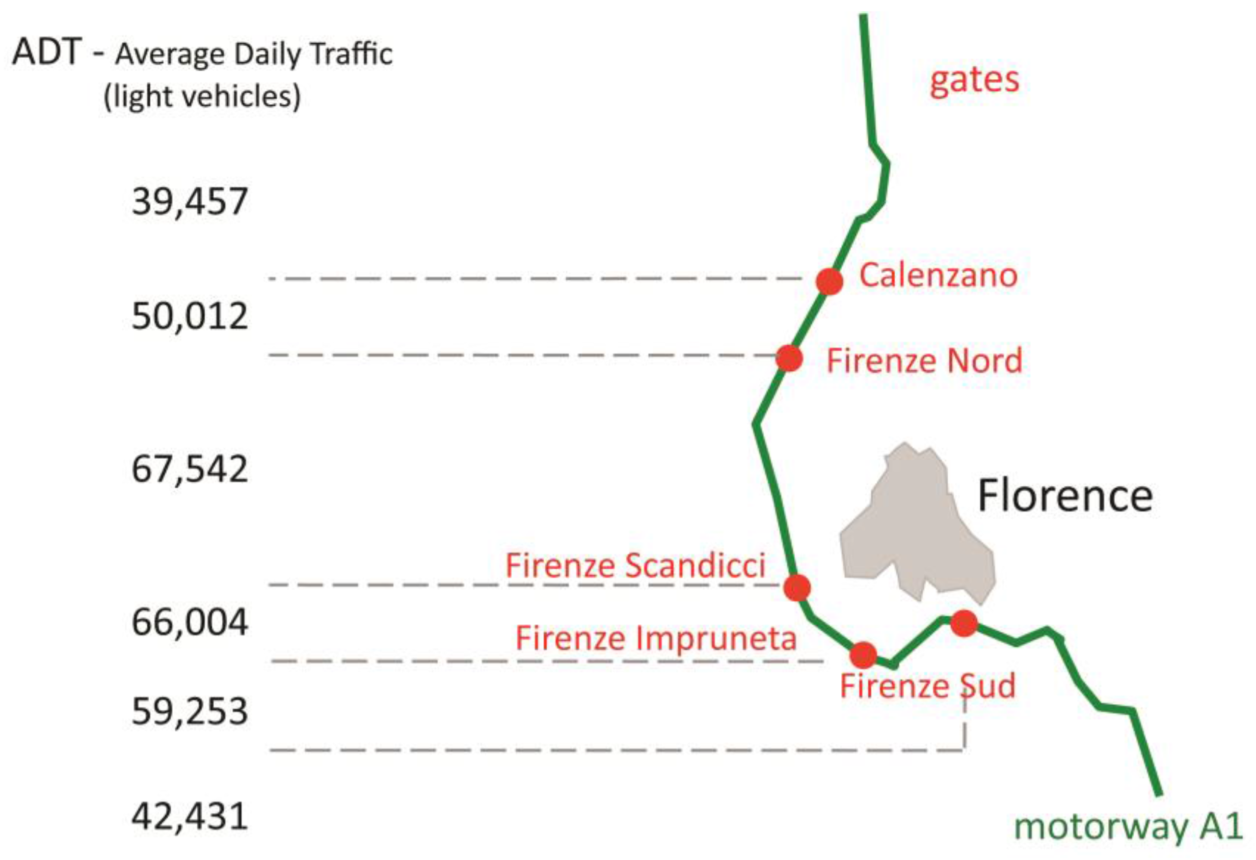
The motorway A1 opened in 1964 and thereafter, subject to upsizing works, was first reached by the sprawling Florence in the 1970s and then swallowed within the conurbation at the end of the century. In the Florentine area, the motorway has five toll gates for entrance and exit (namely, from south to north, Firenze Sud, Firenze Impruneta, Firenze Scandicci, Firenze Nord, and Calenzano); in addition, the settlement hosts two other motorway gates, Prato Est and Firenze Ovest, on motorway A11. The traffic data for the A1 (light vehicles) in 2014 around the gates of Florence are here represented in
Figure 2, which allows us to easily notice the sharp rise in average traffic volume as soon as the motorway enters the Florentine area.
It hence appears clear that traffic on motorway A1 is strongly increased by local traffic,
i.e. car movements with both an origin and destination within the Florence urban area. In other words, the difference between the average values within the Florence area (50,000/67,500 light vehicles) and the values outside (around 40,000 light vehicles) can be clearly considered just as urban traffic. If we then focus on the Florence area, and observe only the vehicles that in 2014 passed through the local gates of the motorway A1, their traffic data, provided by Autostrade per l’Italia S.p.a., operator of the motorway, are here shown in
Table 1 and
Table 2.
The data reported in the last table are especially clear and highly impressive. Over 60% of the total vehicular movement locally entering the motorway actually has a local destination, confined inside the Florentine area; values go as high as 70% for some of the toll gates. The above data can be summarized as follows: A significant amount of the motorway traffic in the area of Florence is actually local—that is, urban—traffic, on top of the heavy vehicular traffic running down the peninsula and making the Autostrada del Sole a very crowded motorway, with high incidence of traffic jams and car accidents. Conversely, a large amount of vehicular traffic to and from locations within the Florentine conurbation does actually use the motorway, preferring it to the urban grid, despite the toll payment its use involves. As a matter of fact, the seven motorway toll gates appear to function mainly as urban network nodes, rather than extra-urban movement terminals.
The question this situation imposes is whether this traffic assignment can somehow be acknowledged as influenced by the structure of the settlement; or, at the same time, if is it possible to find out in the configuration of the grid of the conurbation some clues that the grid configuration itself is the primary element addressing the route choice towards the use of the motorway. In order to answer this question, a configurational analysis of the settlement was therefore carried out, beginning from a diachronic analysis, aimed at reconstructing the genesis over time of the grid configuration, and then focusing on the present state of the system.
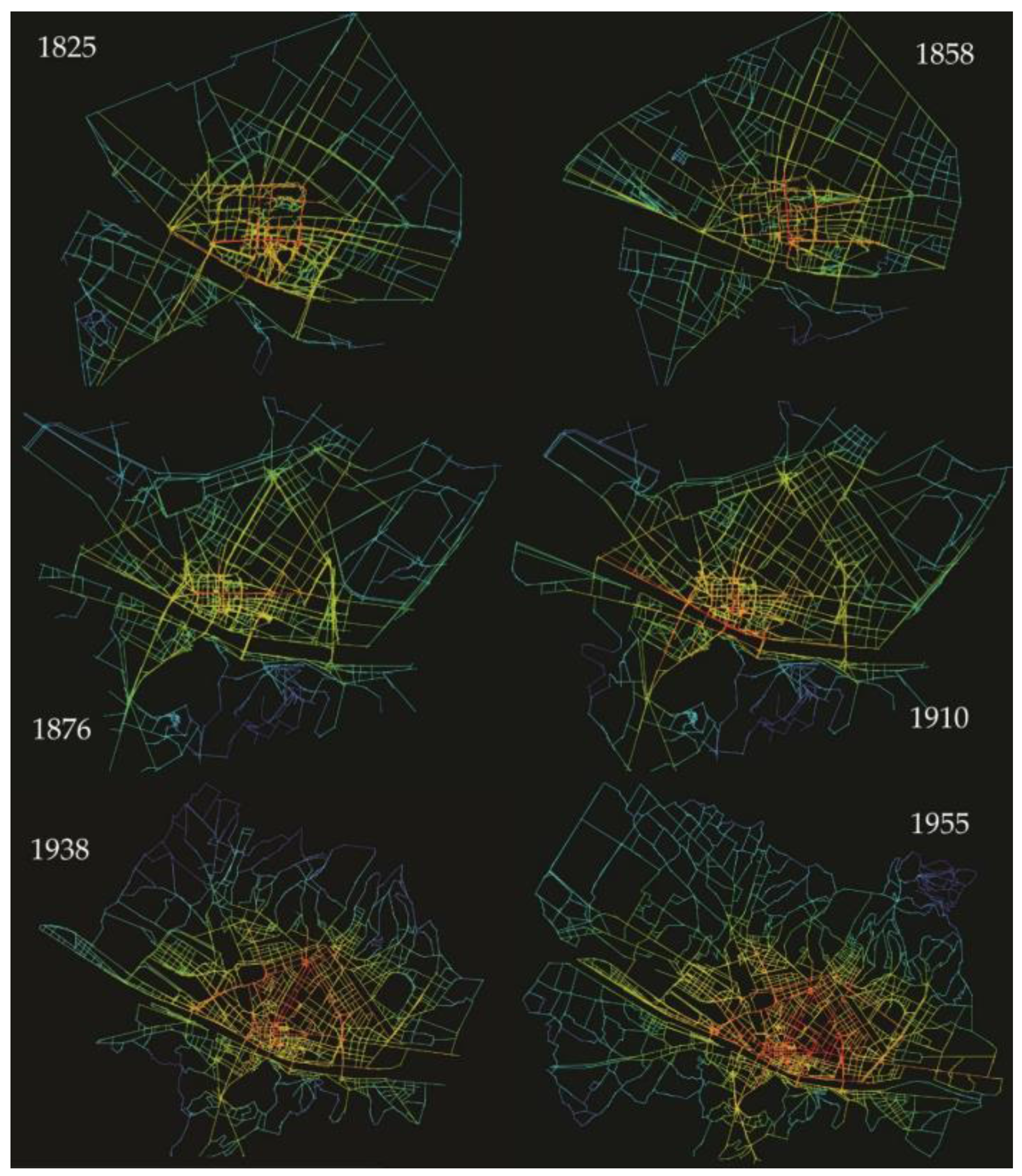
In order to conduct a diachronic analysis of the settlement, nine significant dates have been selected, suitable for identifying many epoch-making moments and representing meaningful milestones in the modern growth of Florence. The first one, year zero in this diachronic path, is 1825, the date of the Lorraine cadastral registry, which capillarily, reliably, and in detail reproduces the consistency of the city in 1:1250 scale, thus registering its planimetric state immediately before the beginning of modern urban growth. Apart from a few punctual transformations, such an urban state can be said to be fundamentally unchanged with respect to the golden era of the Renaissance. The second date is 1858, the year before the end of the Lorraine rule and the subsequent annexation to the Kingdom of Italy, when the planimetric layout provides evidence of the first changes of modern times, such as the urban development around the railway stations. The third date is 1867, a crucial moment as it represents the six years in which Florence was the capital of Italy, and, above all, reproduces all the transformation works carried out for such a role; among them, in particular, are the demolition of the ancient town walls, their substitution with a ring boulevard, and the realization of the first
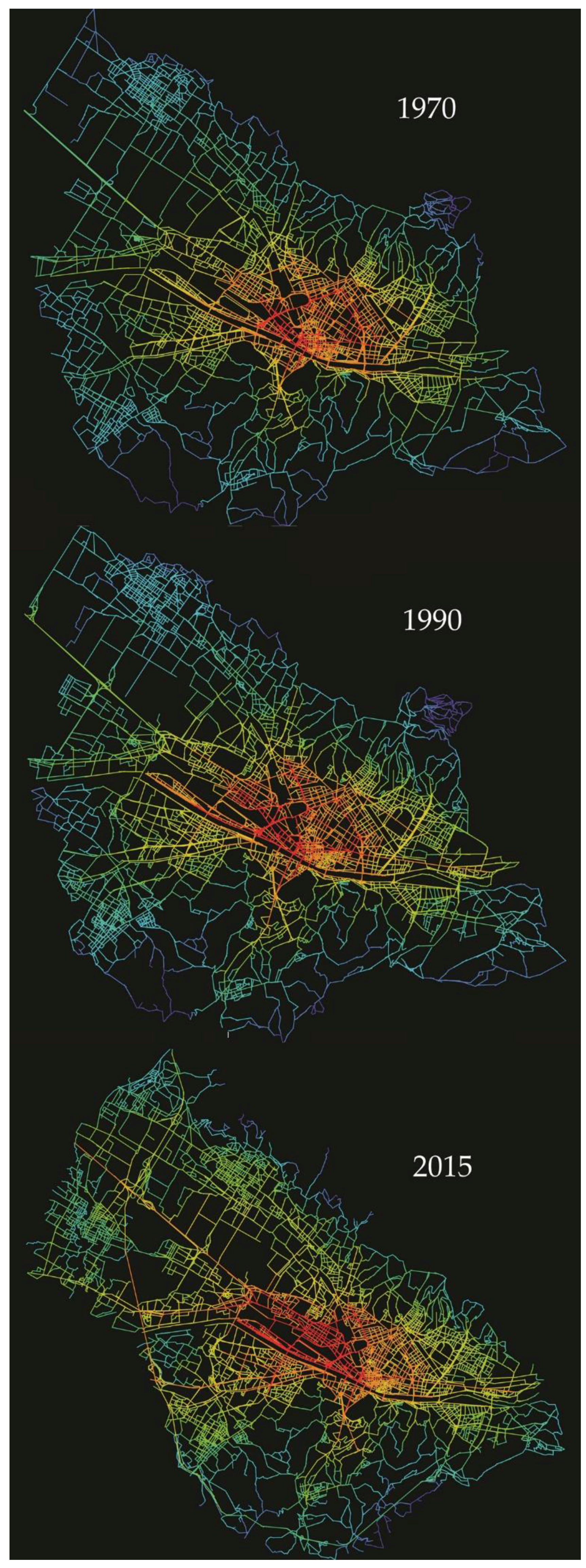
extra moenia residential developments. The fourth and fifth dates are 1910 and 1938, key dates in the progressive consolidation of the radial growth out of the inner core. The sixth date is 1955, reproducing the saturation of the flatland towards the south and east, as well as the beginning of the unidirectional growth towards the northwest, strengthened in the following state, in 1970; the conclusion of this growth is attested by the cartography at the eighth and ninth dates, 1990 and 2015, respectively, with the progressive merging of the northwestern urbanization with the pre-existing urban settlements and the making of the present conurbation, swallowing and including the layout of the motorway, as shown in
Figure 3. The grid corresponding to each of the dates above was analyzed by axial analysis.
The distribution of integration value in all the maps, chromatically represented with warm colors for integrated lines and cold colors for segregated ones, is here summarized in
Figure 4 and
Figure 5; they can be directly compared, since the integration value is a normalized index with respect to the number of lines and does not depend on the size of the system.
Figure 4 represents the distribution of integration in the lines of the axial maps in the period 1825–1955, thus preceding the actual emerging of the conurbation;
Figure 5 instead refers to the subsequent period 1970–2015, characterized by the increasing presence of a conurbative settlement. As the system has greatly increased over the years (as can be seen in
Figure 3), it was here preferred to use in
Figure 4 and
Figure 5 different scales of representation, in order to maintain a full view of the whole system and clearly describe the distribution of values and their trends over time.
Some considerations arise from those results. First, a progressive shift of centrality, from the geometric center of the inner core towards the external radial developments, is clearly shown in
Figure 5. While in the first three maps of the 19th century the strongest integrators appear to steadily persist, coinciding with the cardus and decumanus of the original Roman layout of the city, in the very heart of Florence, the outer ring appears gaining more and more attractiveness since the early twentieth century. The making of the conurbation, in the last decades of the century, appears to involve the clear orientation of the integration core towards the north; up to the last data point, in 2015, when it appears steadily anchored between the ancient town walls and the recent northern developments (
Figure 5).
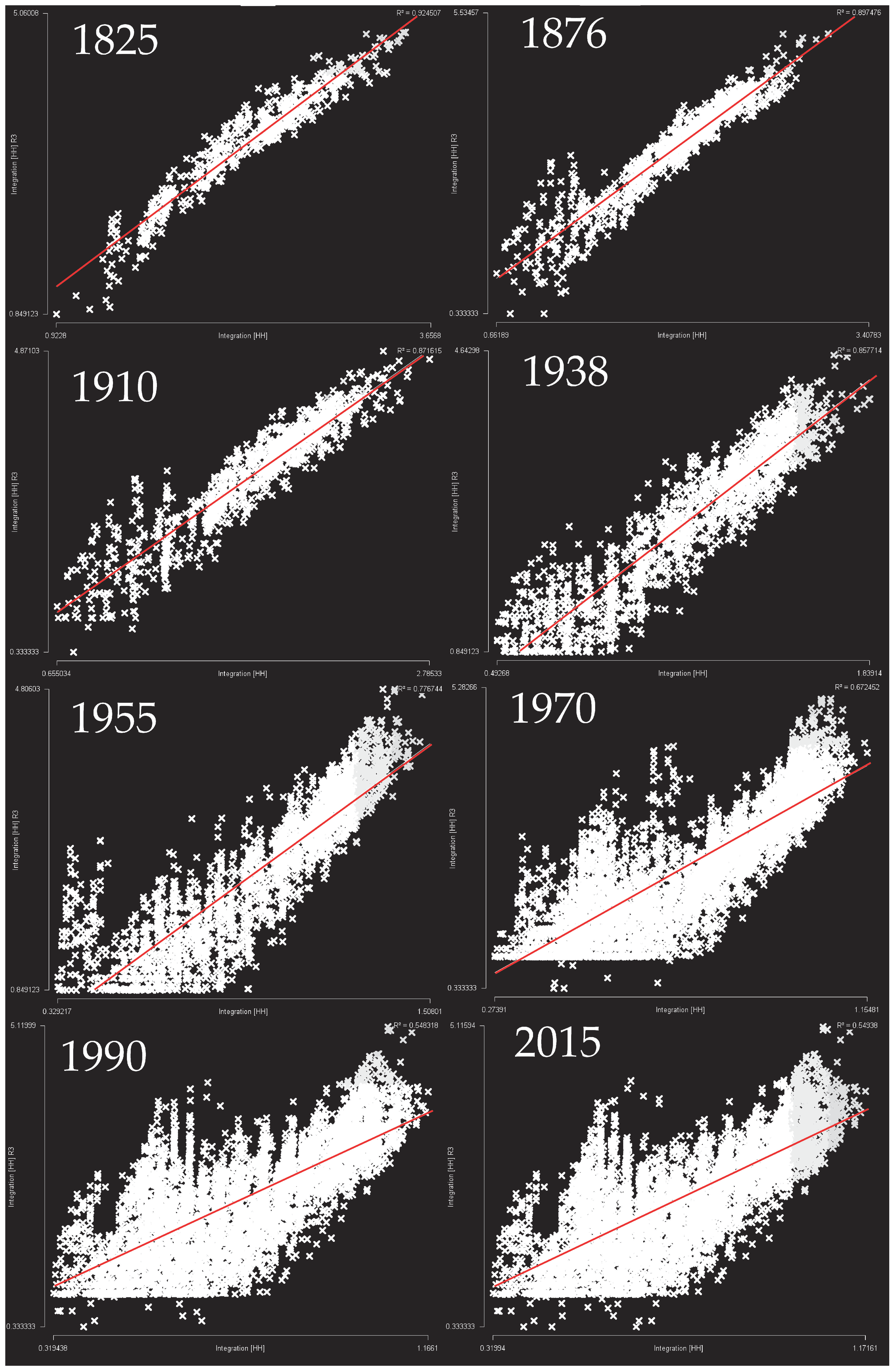
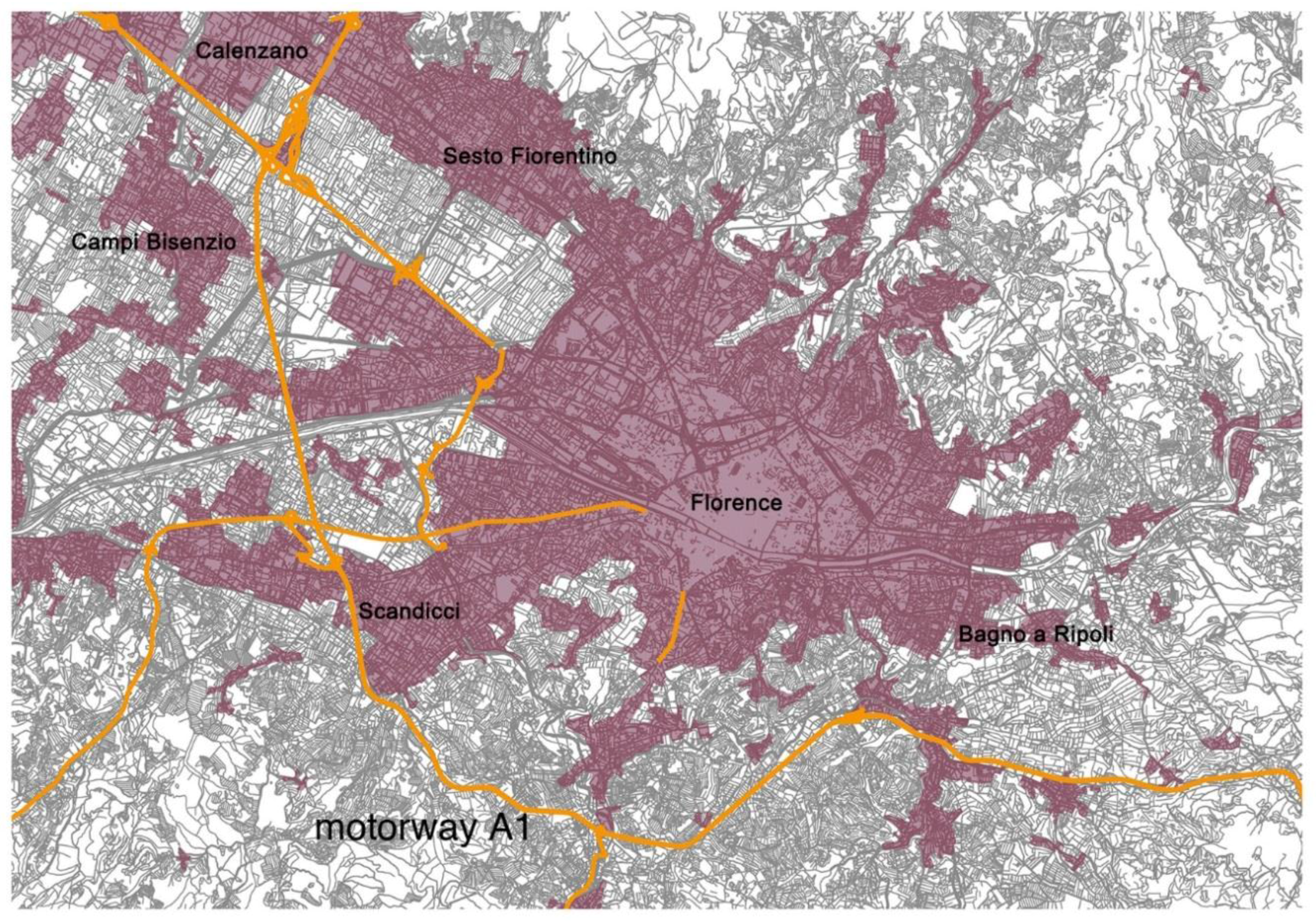
Some interest will arguably arise from the observation of the distribution of another configurational index, the local integration value, which is computed by taking into account only the lines lying within a topological circle with a radius of 3 (in other words, radius 3 integration measures the mean depth of lines up to three steps away from each line in turn, which is the most commonly used value of radius for local analysis). As can be seen in
Figure 6, the distribution of this parameter in the axial map of the present Florentine conurbation pinpoints the presence and the persistent local integration of the pre-existing urban nuclei: Florence, of course, but also Bagno a Ripoli, Calenzano, Scandicci, and Sesto Fiorentino. A first inference can therefore be drawn out of such an observation: since integration proved to be a reliable indicator of centrality (defined as attractiveness towards activities), the recent growth of Florence and formation of the conurbation has certainly caused a progressive northbound shift of centrality, to the detriment of the inner core; yet, the pre-existent nuclei—Florence, above all, but also the others in the surroundings—continue to play the role of local centers, mainly oriented towards small radius activities, as well as representing local urban identities.
The results above suggest investigating around a second-level configurational index, i.e., the coefficient R2 of the correlation of local integration versus the global one, described above as “synergy value,” accounting for the extent to which local centralities depend on the whole pattern of centrality. The idea is that when the local perception actually corresponds to the global geography of the settlements, it will support and orient the path finding all over the grid. In the case of a strong correlation, local integrators are also prominent integrators at a global scale, thus creating a stronger and perceivable interface between the whole settlement and its individual parts. This index can therefore be usefully assumed to be an indicator of the degree to which the different scales of the settlement are actually correlated, so as to synergically concur to the global working of the city, which is commonly acknowledged as a vital property in urban areas. In the case of a strong correlation, local integrators are also prominent integrators at a global scale, thus creating a stronger and perceivable interface between the whole settlement and its individual parts.
In
Figure 7 the diachronic trend of synergy coefficient, from 1825 up to the present time, is summarized, showing a clear weakening of the correlation in the second half of the twentieth century (from
R2 = 0.92 to
R2 = 0.55), as a result of the sprawl of Florence and the growing of the conurbation. The specific cause of this degradation of synergy is the development of the northern neighborhoods, mainly represented by the top-left dots in the scattergrams, which appear to have (comparatively) high values of local integration but low values of global integration, thus weakening the strength of the correlation.
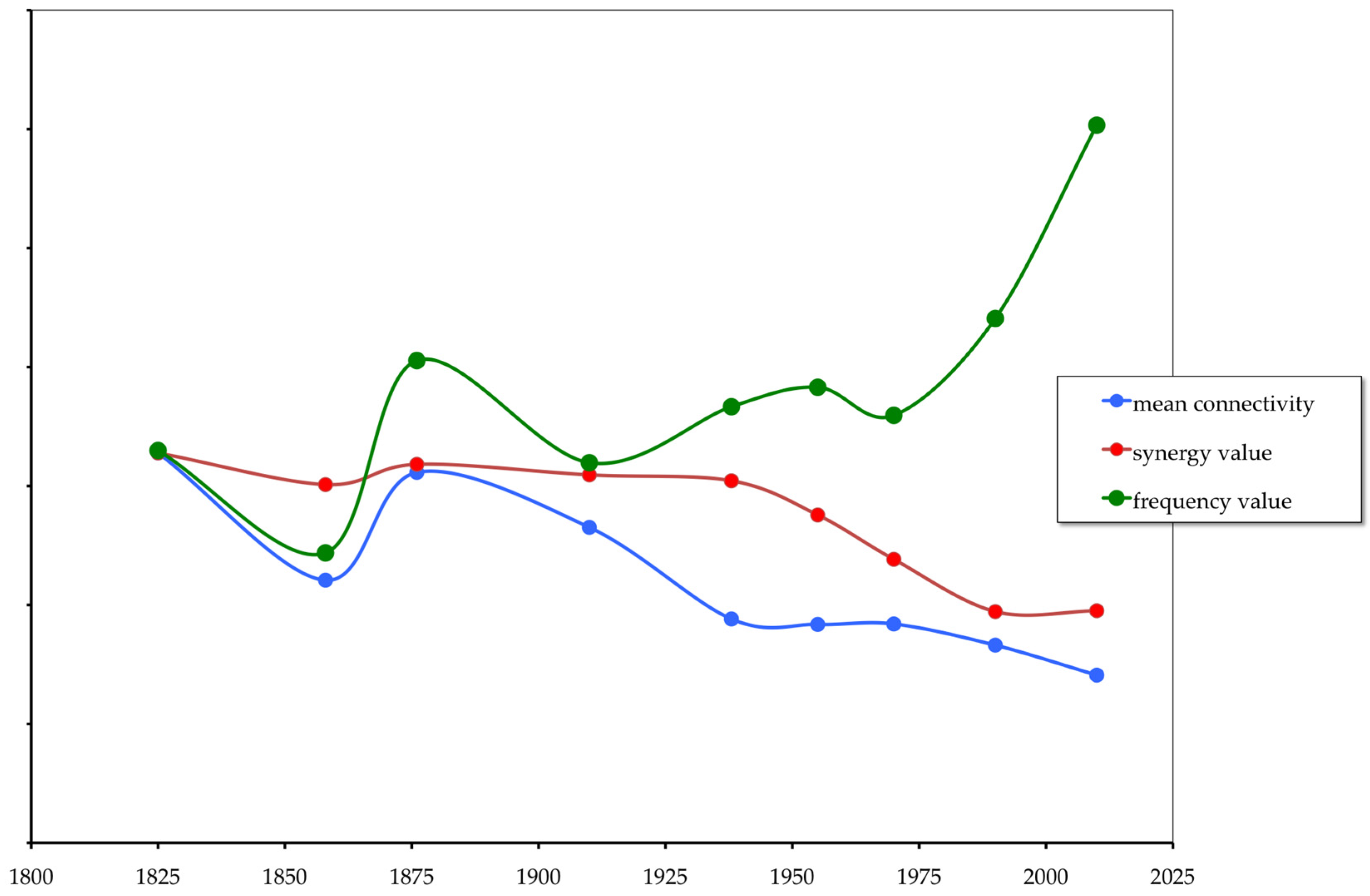
Furthermore, as seen before, the synergy coefficient is also one of the three parameters of network resilience, besides the mean connectivity and the frequency value.
Figure 8 summarizes the diachronic trend of those parameters in the period 1825–2015, highlighting a clear increase in the spatial vulnerability of the system in the last decades; all three parameters appear to agree on this spatial phenomenon. In fact, the decrease in the mean connectivity value stands for the decrease in redundancy of connections, which is commonly acknowledged as a fundamental element of urban resilience [
42], as well as a precious source of urban life [
43]. Moreover, the decrease in synergy value stands for the weakening of the spatial relationship between the whole settlement and the local centers, which are scattered around and drift away, detached from the global spatial structure. Furthermore, the sharp rise of the frequency value stands for the strong polarization of the network structure around a limited number of road axes. Just like the tree-like pattern described by Christopher Alexander, a tree whose major trunk is here the motorway, distributing movement flows to the neighborhoods scattered around: “Whenever we have a tree structure, it means that within this structure no piece of any unit is ever connected to other units, except through the medium of that unit as a whole” [
44] (p. 50).
All those phenomena appear attested in the grid configuration corresponding to the first ‘70s, and can be easily referred to the making of the conurbation and the embedding of the motorway within its grid: at present, the whole conurbative settlement actually appears to be highly dependent on a handful of distributor roads, and, above all, on the motorway itself, by far the most used one, as provided with the highest values of choice: should any perturbation affect this road (as it is likely to occur, due to possible car accidents or traffic jams, unfortunately so frequent in this crowded section of road), the whole urban system would be at risk of globally collapsing.
Should any disruption affect this road (as is likely to occur, due to possible car accidents or traffic jams, unfortunately very frequent in this crowded section of road), the whole urban system would be at risk of collapse.
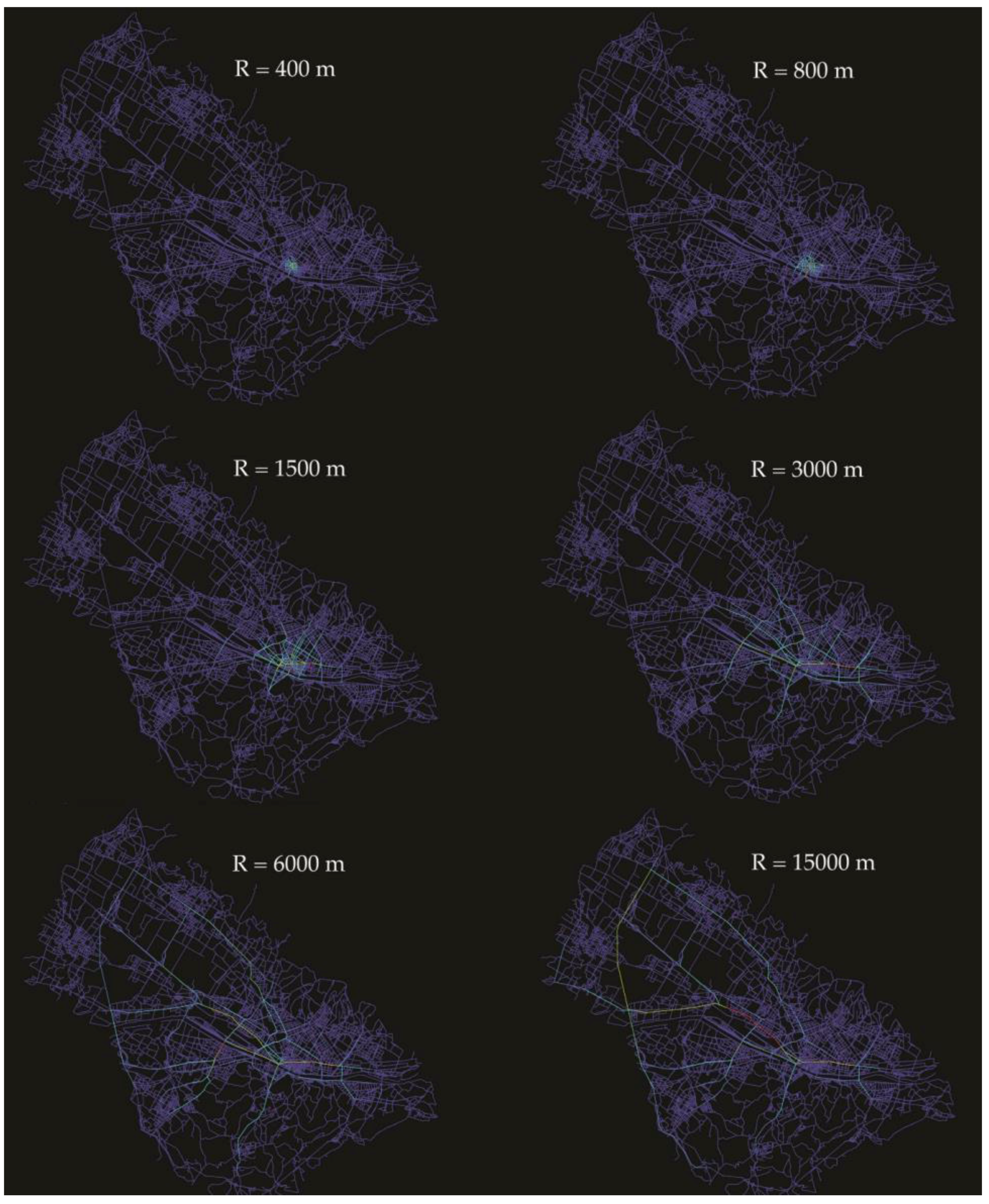
The literature on the issue [
15,
26,
45] suggests using angular segment analysis, according to different values of metric radius, to determine likely patterns of movement. Such an analysis was therefore applied to the present grid of Florence, with a radius varying from 400 m up the highest value of 15,000 m in order to encompass the whole conurbation. Obviously the lowest values of radius are expected to provide the likely pattern of pedestrian movement, while the highest are suitable for reproducing the distribution of vehicular traffic.
The results of these analyses, for what concerns the distribution of choice values, are summarized in
Figure 9 and reveal that the distribution of pedestrian movement (
R = 400/800 m) mainly involves the streets of the inner core (in red), making the orthogonal grid of the ancient Roman city clearly emerge; on the other hand, vehicular traffic flows (
R = 15,000 m) are particularly intense outside the historic center, towards the northern edge of the conurbation.
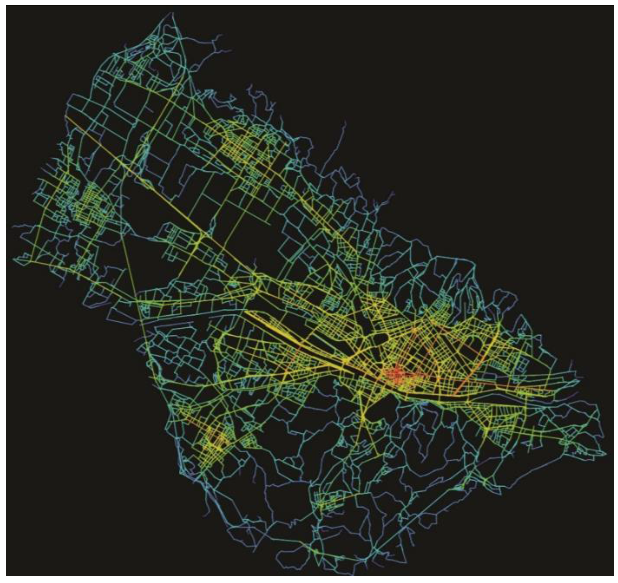
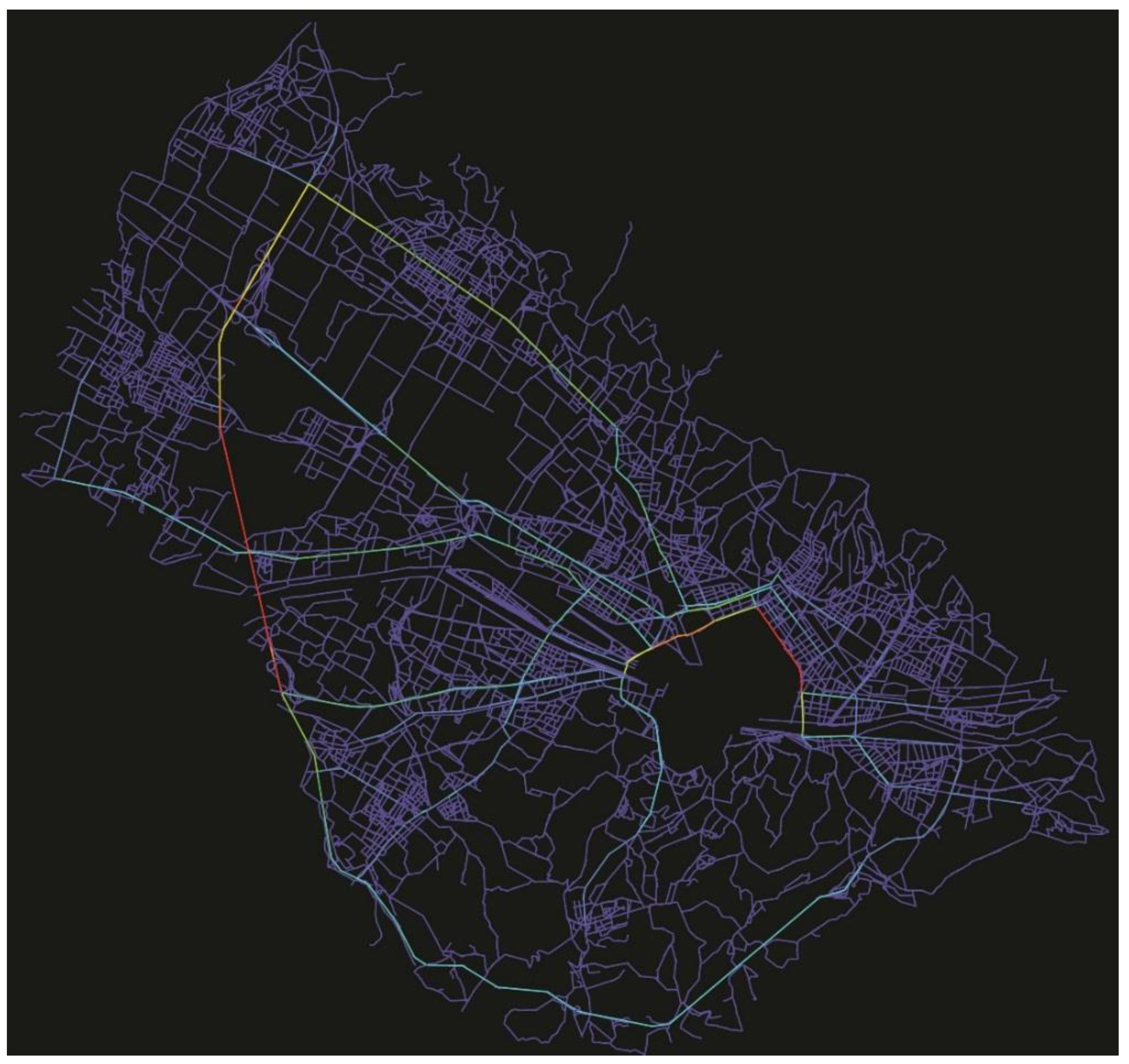
A further, appropriate refinement in the representation of vehicular movement patterns would then result from the clearing of the limited traffic zone out of the urban grid. As a matter of fact this zone, which at present approximately covers the area encircled within the ancient town walls, is prohibited to ordinary vehicular traffic, and therefore its streets, unavailable to vehicles, do not actually contribute to the road network of the settlement. As a result of the cancellation of those streets, the distribution of choice values on the resulting grid, with a radius of 15,000 m, appears as shown in
Figure 10.
The figure above highlights two major traffic distributors, as provided with the highest choice values and thus marked in red: the road segments composing the ring route surrounding the historic center—the so-called
viali, which in 1865 were built to replace the pre-existing ancient town walls; and the Florentine section of the motorway A1, appearing as an outer ring on the western side of the conurbation. This result appears to correspond exactly to the actual phenomena of traffic congestion in the area of Florence, as it is perceived in the common view as well as objectively measured by direct survey. However, it also appears to emphasize the traditional classifications made by traffic engineers: “roads to be built as traffic conduits” (here represented in green and red) and “roads to be built for the needs of the local communities to give access to their homes” (here in blue) [
4] (p. 297), as was mentioned above in the background. Two aspects arising from the results summarized in
Figure 9 and
Figure 10 are worth highlighting. First, the motorway appears to divert a significant amount of traffic flow from the streets of the urban fabric, thus depriving them of the precious byproduct of origin–destination movements [
11]. Moreover, on the traffic side of the matter, it has to be noted that, while the few large-scale movement arteries mostly run on the edge of the settlement, the local roads for short-range (
R = 400/1500 m) movements, suitable for pedestrian movement, are exclusively encompassed within its inner core, and hence are practically non-existent across the wide conurbation. The hierarchical sequence of traffic distributors/local traffic roads/pedestrian paths, traditionally established by the manuals of traffic engineering for the efficient distribution of urban movement flows, here appears to be broken and incomplete in most of the settlement, mainly due to the absence of a much finer scale structure outside the historic center suitable for receiving and capillarily distributing local traffic. This is undoubtedly a serious deficiency, since cities, as Hillier wrote, quoting John Peponis, “in a sense, are interfaces between scales of movement” [
11] (p. 56).
4. Conclusions
In conclusion, four main aspects seem to arise from the results above. First, the diachronic analysis of the Florentine conurbation and the observation of its present configurational state confirm the actual progressive shifting of centrality from the original inner core towards the northwestern developing area. Secondly, the resilience of the whole system appears to be weakening as a result of the recent growth of the conurbation and the strong polarization of the network structure around a limited number of road axes, including the motorway A1, which laps the conurbation on its western side. Thirdly, a large amount of internal movement bypasses the urban grid of the conurbation, moving from an urban origin to an urban destination via the motorway, despite the cost of the toll. The vast majority of the accesses to the motorway through the gates of the Florentine area actually correspond to local (that is, internal) movement. Furthermore, the motorway A1 appears to be supplementing the urban streets, thus improperly supporting the working of the system; this obviously involves a local worsening of traffic conditions, already difficult because of the heavy traffic running down the Italian peninsula. Finally, apart from this effect on traffic, the local role of the motorway also diverts a significant amount of vehicular traffic flow from the streets of the urban grid, involving the loss of the fertilization benefit the irrigation of through-movement provides. These aspects are worth highlighting as they clearly affect both the inner geography of the settlement and merely traffic issues, linking them and making evident the mutual influence of one on the others.
A couple of relevant questions still appear open, suggesting further areas of development for this research. The first issue is public and collective transport, and concerns the way in which it meets and satisfies the demand for movement in the metropolitan area, thus reducing traffic on the motorway. The second issue concerns the urban grid, and consists of identifying possible solutions to the problems discussed above using a configurational approach to simulate the effect on traffic of the introduction of inner road connections.
Aside from this case study, this method can be extended to the general issue of motorways in metropolitan areas, in order to evaluate the relationship between the motorway and the urban road network and the actual entanglement of inter-urban roads within the system of the conurbation: a widespread phenomenon, commonly resulting from the growth of the urban settlements and their sprawl into the surrounding rural areas.
Even more generally, the configurational approach, which appraises the urban grid as the interface between the physical city and the phenomena that occur along its paths, appears a suitable tool for interconnecting spatial issues and traffic questions, so as to bridge the traditional gap between urban design, focused on the morphologic features of blocks and buildings, and transport analysis, strictly concerned with the distribution of movement flows on the street network.


