
A Semantic Registry Method Using Sensor Metadata Ontology to Manage Heterogeneous Sensor Information in the Geospatial Sensor Web


Abstract
:1. Introduction
- ●
- Integrating semantics into a registry information model (such as ebRIM) using three different methods: (a) mapping from Web Ontology Language (OWL) elements to ebRIM elements using EXtensible Stylesheet Language Transformations (XSLT) documents, as in the case of GeoNetwork (GN)-ebRIM [17]; (b) adding new classes, classification schemes, associations, and slots with semantic information to extend the ebRIM, as in the case of the George Mason University (GMU)-CSW [16]; and (c) disassembling the concept of ontology and relationships to extend the ebRIM [18].
- ●
- Adding semantic information to a catalog using two different methods. One is to extend the catalog interface for supporting a semantically augmented query directly [19,20]. The other is to create semantic middleware for a catalog service [21] that does not change the service interfaces [22,23,24]. For example, the Sensor Observable Registry (SOR) [25] has to make a connection with a sensor discovery service (e.g., CSW) to achieve sensor discovery enhancements.
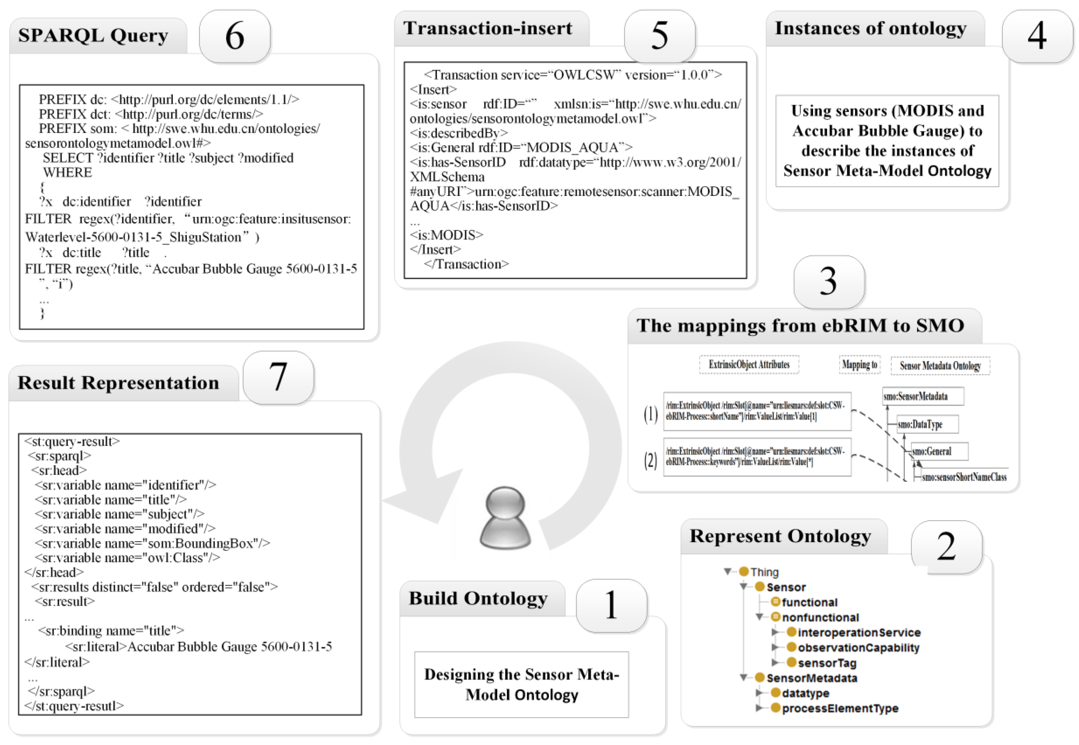
2. Methods for Enabling a Sensor Semantic Registry
- Model (steps 1–2): building a sensor metadata ontology (SMO).
- Data (steps 3–4): providing the mapping for storing sensor metadata in the ontology to obtain the data from the registry service.
- Experiment (steps 5–7): implementing the sensor semantic registry service (SSRS).
2.1. Model Ontology for the Semantic Registry
- ●
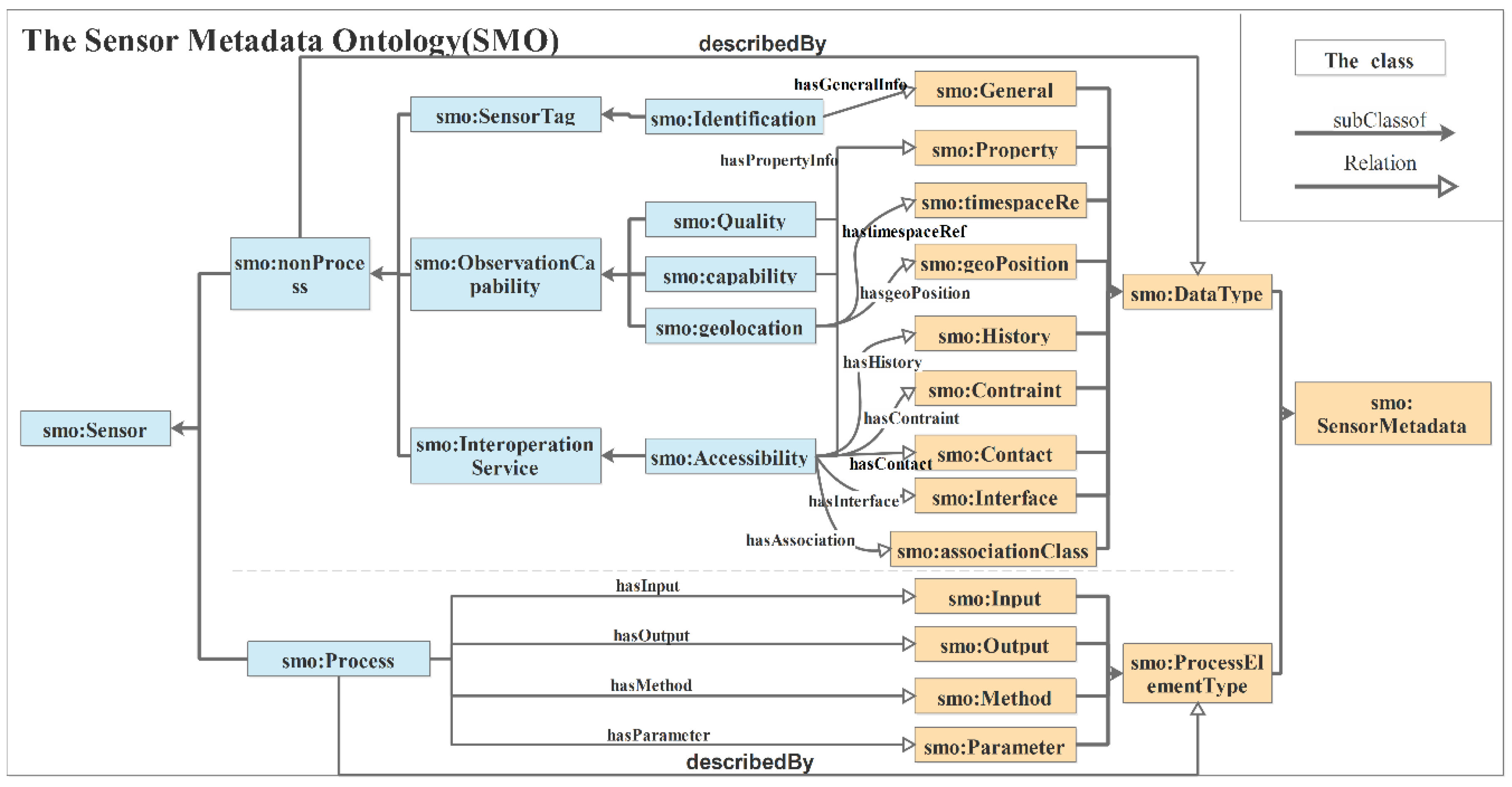
- The pattern of the ontology describes a sensor in terms of its information, its data type, and the process element type it takes.
- ●
- The content of the ontology includes the concepts and associations of sensor metadata from the description of the sensor model. Additionally, it captures the meanings, properties, and relationships of sensor resources.
- Module 1: conceptual sensor informationAccording to previous research [8], the properties of sensor processing include inputs, outputs, parameters and methods. In the ontology, these process properties could be described by the “smo:Process” class, and other sensor properties could be represented by the “smo:nonProcess” class.
- ●
- The “smo:Process” class describes the conceptual properties of a process.
- ●
- The “smo:nonProcess” class includes three sub-classes for describing more detailed information than the sensor’s thematic features [26,27].
- (a)
- SensorTag: For sensor recognition, the “smo:SensorTag” and “smo:Identification” class are used as sensor tags.
- (b)
- ObservationCapability: A sensor is often described by information that includes its physical, measuring, and communication properties and the area observed by the sensor. For any sensor property, the performance of the sensor might be affected by prevailing environmental conditions as well as its position and location. These properties are modeled as observation capabilities. Thus, the observation capabilities of a sensor can be specified using related records. For example, we developed the “smo:capability”, “smo:geoLocation” and “smo:quality” classes, which are inherited from the “smo:ObservationCapability” class.
- (c)
- InteroperationService: To describe constraint information and to access the sensor, the “smo:Accessibility” class could reflect the fact that the observation capability of a sensor is affected by its position and location.
- Module 2: sensor metadata
- ●
- DataType: The types of data (described by the “smo:datatype” class) that describe the non-process information of a sensor. This part contains nine sub-classes: “smo:General”, ”smo:Property”, ”smo:timespaceRef”, ”smo:geoPosition”, ”smo:History”, “smo:Constraint”, ”smo:Contact”, ”smo:Interface”, and ”smo:associationClass”.
- ●
- ProcessElementType: The types of process elements (described by the smo:ProcessElementType class) describe the process information of a sensor, which includes the “smo:Input”, “smo:Output”, “smo:Method”, and “smo:Parameter” classes.
2.2. Mapping for Storing Sensor Metadata in Ontology
- Mapping of the rim:ExtrinsicObject (basic attributes)The objectType attribute in the GEOSENSOR-CSW model maps to the “smo:SensorMetadata” class to describe the type of rim:ExtrinsicObject, e.g., where one of the object types of the sensor is “system”. The basic attributes of “system” include sensorID, a long name and a description, which could be mapped into the “smo:sensorID”, “smo:sensorLongName” and “smo:sensorDescription” classes of the SMO, respectively.
- Mapping of the rim:ExtrinsicObject slot (additional attributes)The slots of rim:ExtrinsicObject store detailed information pertaining to sensors, such as a short name, keywords, valid time, location, ObservedBoundingBox, inputs, outputs, and parameters. The mapping of the slots is shown in Figure 3.
- ●
- Steps (1) and (2) describe the mapping of short names and keywords.
- ●
- Steps (3) and (4) show the mapping of the attributes of valid time.
- ●
- Step (5) describes the mapping between the location attribute of a sensor and the “smo:sensorLocationClass” class.
- ●
- Step (6) expresses the “sensorBBOXClass” class that can store the area of interest observed by a sensor.
- ●
- Steps (7)–(9) represent that the inputs, outputs, and parameter attributes of a sensor could be mapped into the “smo:Input”, “smo:Output”, and “smo:Parameter” classes, respectively.
- Mapping of the ClassificationSchemeThere are attributes of rim:ClassificationScheme in the sensor registry model that classify the sensor information. We built four subclasses of the “smo:ClassificationClass” class to describe the classifications of “IntendedApplication”, “ServiceType”, “SystemType”, and “OrbitType”. The four subclasses in the SMO include “smo:SensorClassification_IntendedApplication”, “smo:SensorClassification_ServiceType”, “smo:SensorClassification_SystemType”, and “smo:SensorClassification_OrbitType”.
- Mapping of associationsIn the GEOSENSOR-CSW model, there are four sensor associations (ComposedOf, AccessibleThrough, InputConnection, and OutConnection). The related associations could be mapped into the “smo:SensorAssociation_ComposedOf”, “smo:SensorAssociation_AccessibleThrough”, “smo:SensorAssociation_InputConnection”, and “smo:SensorAssociation_OutputConnection” classes.
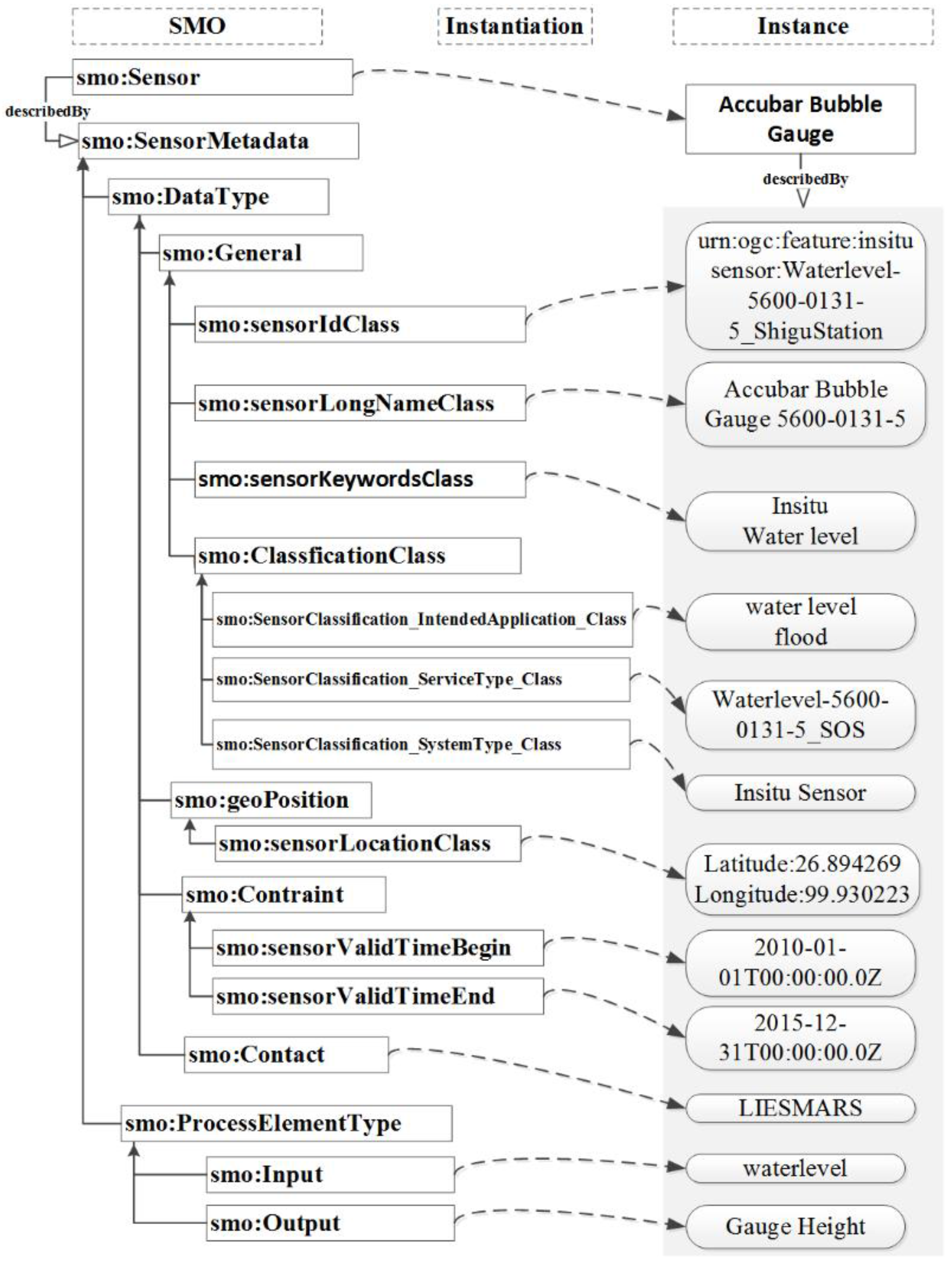
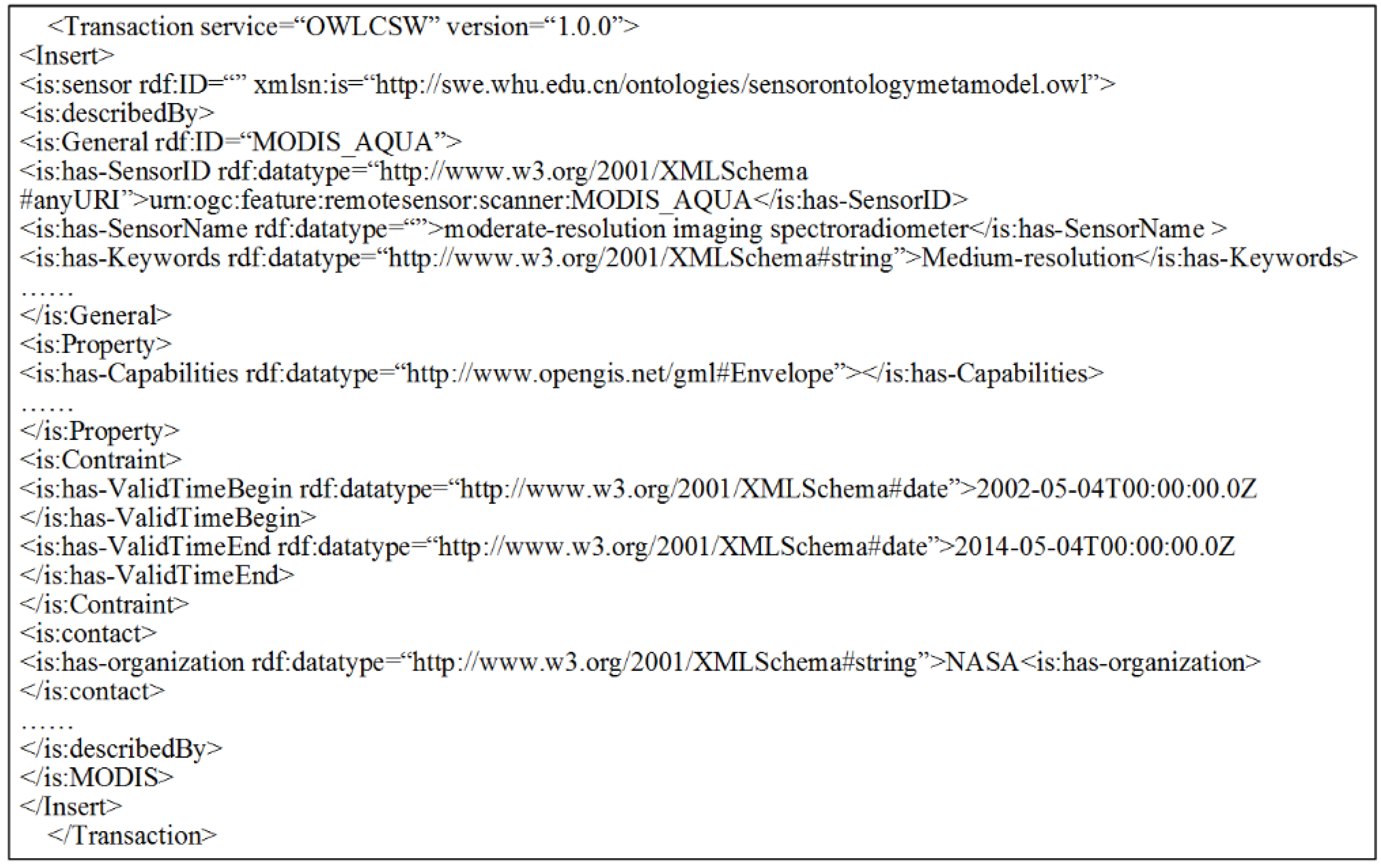
2.3. Instances of the Sensor Metadata Ontology
- The information relating to SensorID, SensorName, keywords, and classification can be described by the “smo:General” class.
- The properties of length, height, width, and observed region can be expressed by the “smo:Property” class.
- The valid observation time of MODIS can be described by the subclasses of the “smo:Constraint” class.
- The contact and interface information can be described by the “smo:Contact” and “smo:Interface” classes, respectively.
3. Experimental Data and Results
3.1. Experimental Data
3.2. Implementation
3.2.1. Semantic Registry of the SSRS
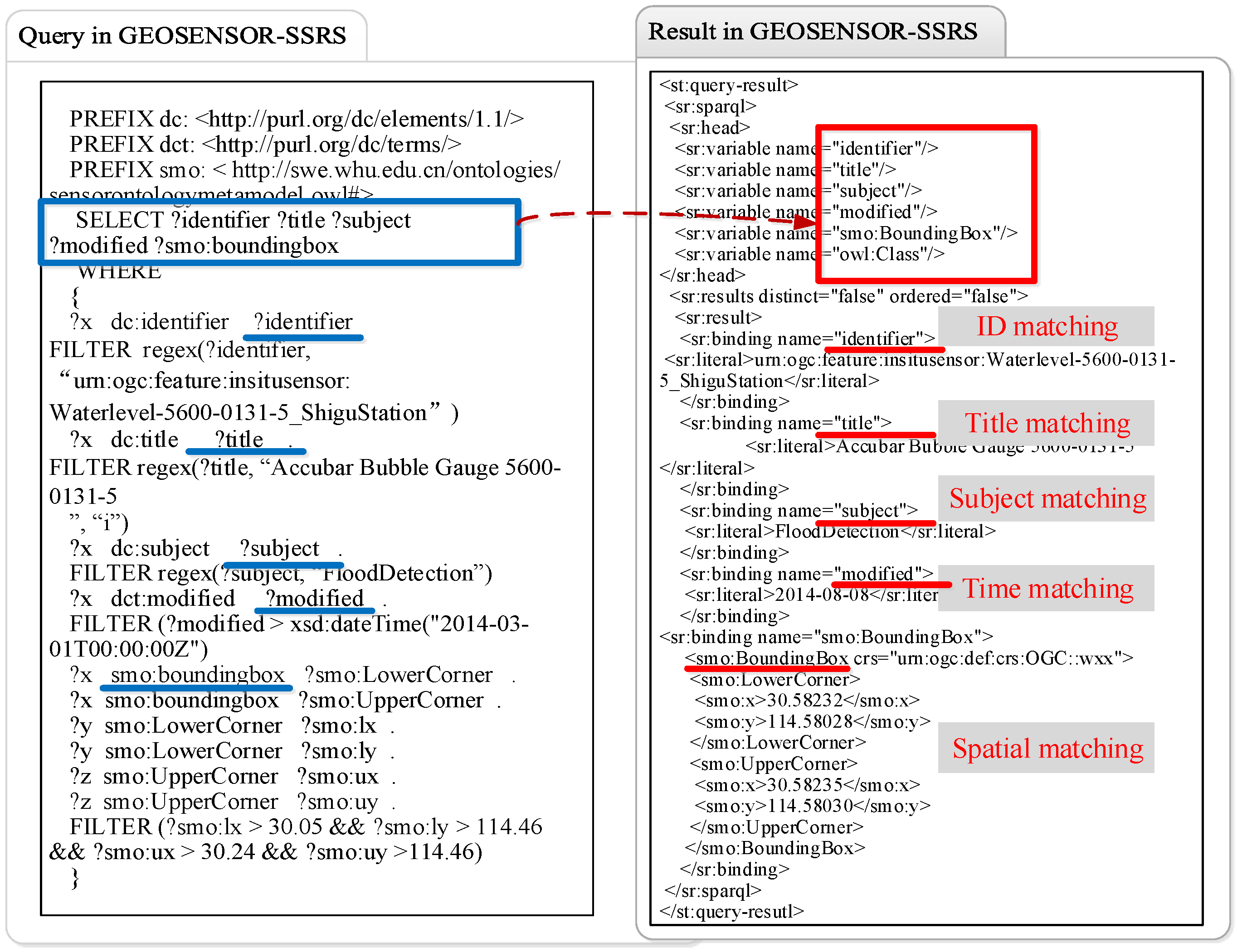
3.2.2. Semantic Query of the SSRS
4. Discussion
4.1. The Comparison between GEOSENSOR-CSW and SSRS
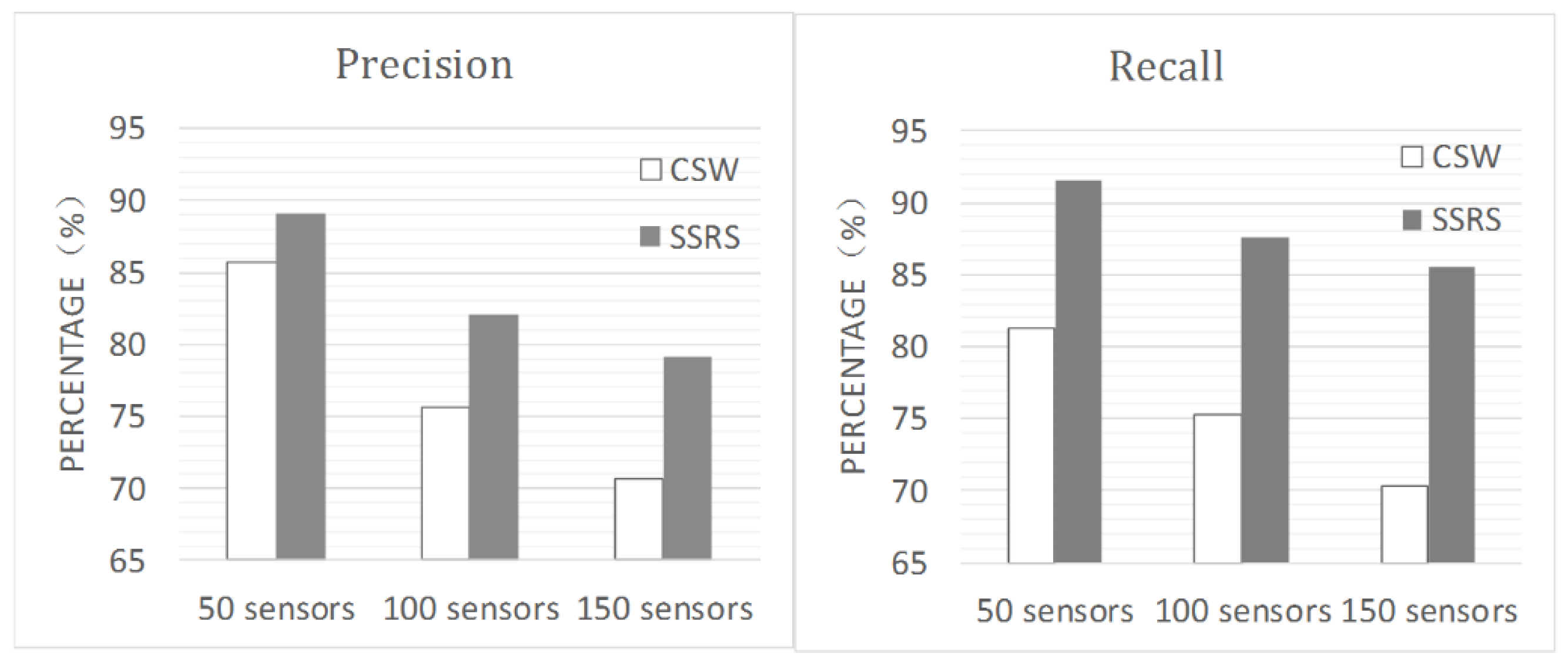
- Precision and recall: Precision and recall measurements were employed to assess the matching quality of information retrieval. Precision is the fraction of retrieved instances that are relevant, and recall is the fraction of relevant instances that are retrieved. Figure 7 shows that the SSRS yielded better precision and recall for GetRecords. When the number of sensors in the experimental data set was 150, the precision for GetRecords was 81.1%, and the recall was 85.6%.
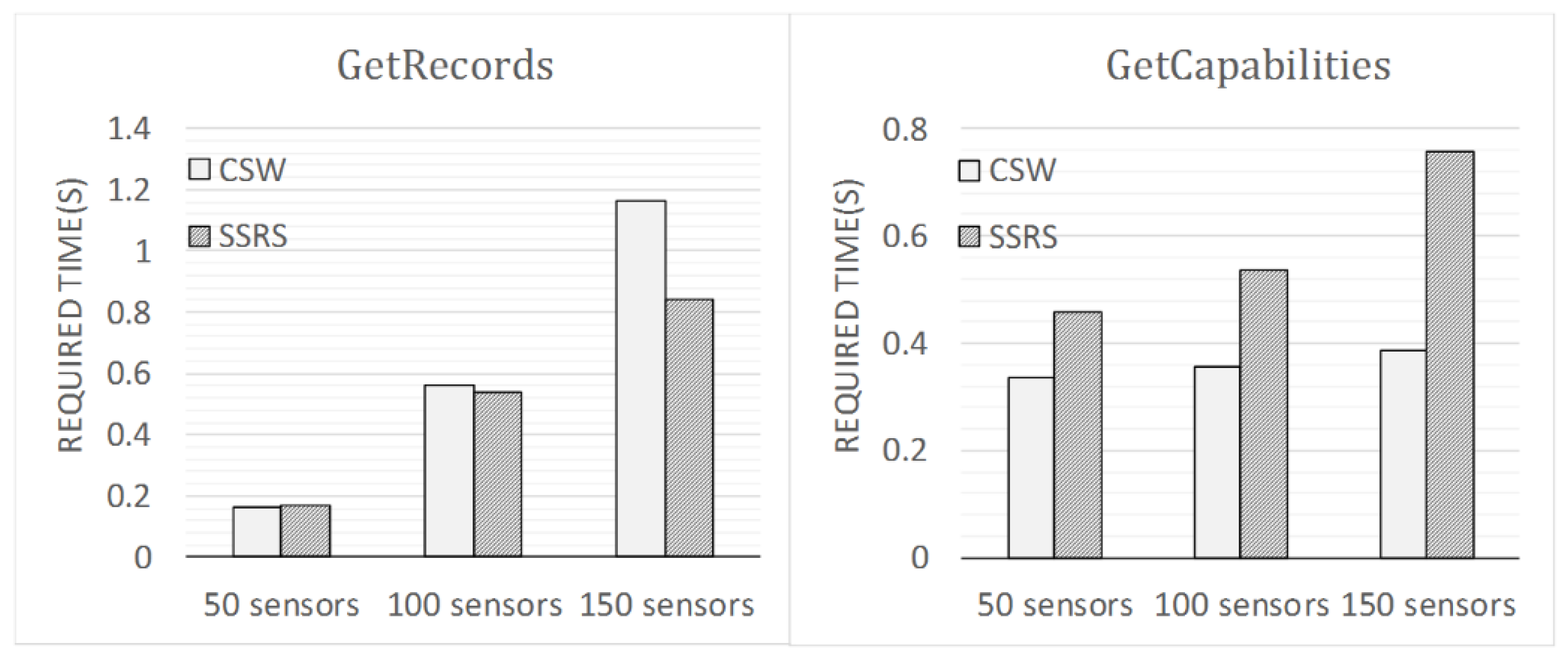
- Time required: With a data set comprised of 150 sensors, the total mean response time for the operation “GetRecords” was approximately 0.841 s for SSRS and 1.162 s for CSW. Figure 8 shows that less CPU (Central Processing Unit) time was required to execute retrieval using “GetRecords” in GEOSENSOR-SSRS than in GEOSENSOR-CSW when the number of sensors in the experimental data set was 100 or 150. However, because the SSRS has a new operation of “Semantic Query”, more CPU time was required to execute the operation “GetCapabilities” in SSRS than in CSW.
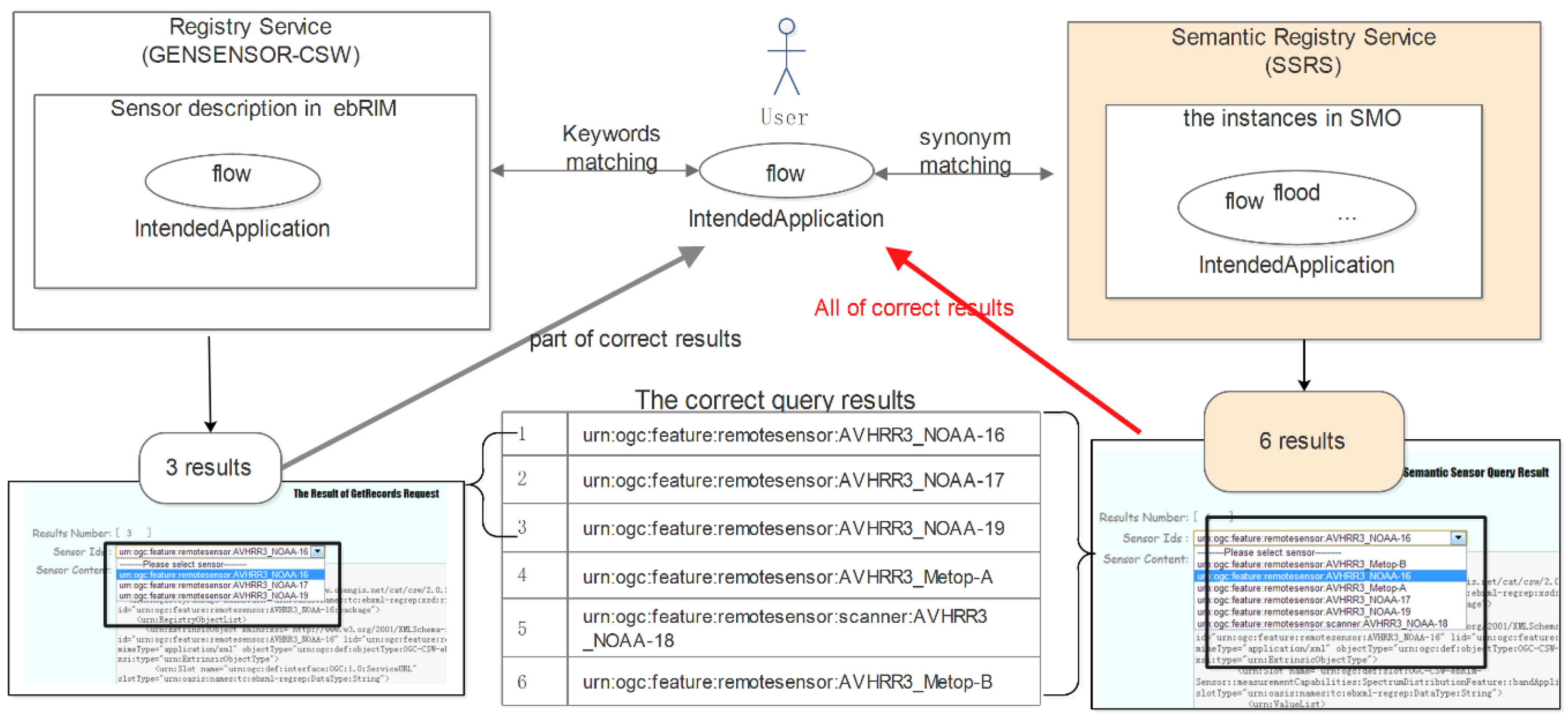
- Synonym query: Additionally, we added the operation “semantic query” in SSRS. It adds a synonym query, as in the operation “GetRecords” of the CSW in flood scenes. In GEOSENSOR-CSW, clients can search for one or more sensors by keywords to match the sensor ID, intended application, and sensor type. However, the service will not respond with all of the related results in the case of synonyms. The sensor semantic registry method could achieve synonym queries with less data loss. For example, when the a user requires information on sensors related to flood detection, the service will automatically search for the synonyms of “flood” in the database, such as “fresh”, “flow”, and “inundation”. The SSRS can enhance the effectiveness of sensor data management and retrieval by providing synonymous results. It can enlarge the retrieval area and enhance the results retrieved by the search engine.
4.2. Comparison with SSN Ontology
4.3. Comparison with Other Semantic Registry Services
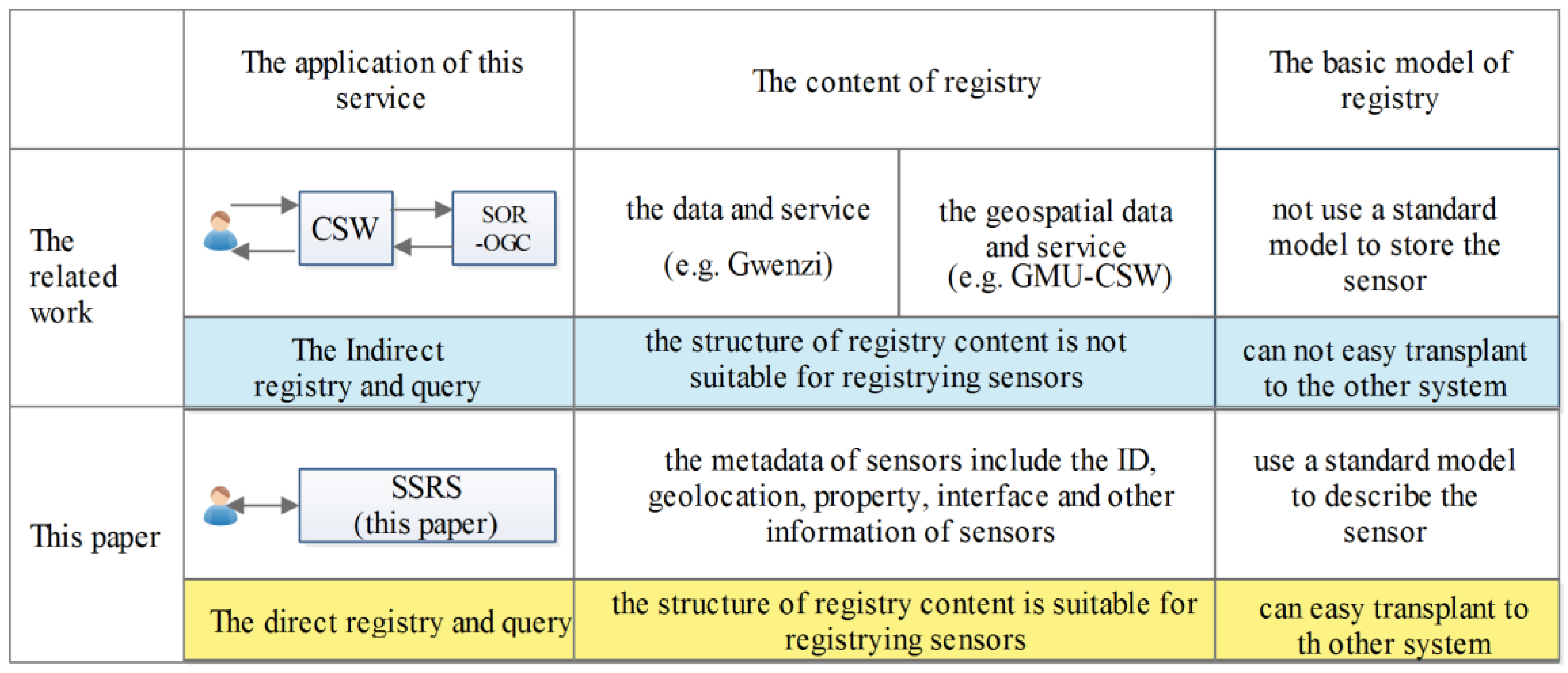
- Comparison of the application mode of the registry method:
- Situation: indirect registry method. The Sensor Instance Registry (SIR) [25] is capable of harvesting, managing and transforming sensor metadata. The SOR is a web service interface that can provide definitions of phenomena observed by sensors for the exploration of semantic relationships between phenomena [30]. The registry method employed by SIR and SOR is an indirect registry. The administrators of SIR/SOR must establish a connection to a generic catalog service that publishes all the pertinent data instances. This method is more time-consuming for sensor registry and discovery and possibly loses information.
- Development: direct semantic registry for heterogeneous sensors. A data and service registry with direct descriptions of semantics in a catalog service is a challenging task. Both the registry service (GEOSENSOR-CSW) and the semantic registry service (GEOSENSOR-SSRS) use a direct registry method. End-users with a specific field of expertise can query potentially interesting sensors directly if the sensors are included within a catalog.
- Comparison of registry content:
- Situation: representing semantics of geospatial data and service. The semantically enhanced GN-ebRIM catalog service that was examined by Gwenzi [17] integrates ontologies and semantic annotations for improving searches for data and services. GMU-CSW [20] uses a registration method with the OWL/OWL-S format for geospatial data and services to support semantic searches. These services have good semantic registry performance, but this method could not represent the semantics of sensor metadata for inference.
- Development: representing semantics of heterogeneous sensors for inference. In this paper, the sensor semantic registry method could transform sensor metadata into an ontology to describe the semantics of sensors. All the metadata related to sensors are described by the Sensor Metadata Ontology, enhancing the efficiency of discovery and supporting the inference of the registry.
- Comparison with the basic model of the registry method:
- Situation: some registry methods use an off-standard registry model. A semantic geospatial service catalog has been proposed by Maué [31] to support the discovery of geospatial services. The Open Geospatial Consortium (OGC) data services, such as the Web Feature Service and the Web Map Service, could be registered in the catalog, but they do not use a standard information model.
- Development: it is necessary to use a standard model language to build the registry model for sharing. In this paper, a normal ontology language called OWL is used for representing the ontology. It will enhance the versatility and ability for sharing of the proposed ontology.
5. Conclusions
- The method of the semantic sensor registry supports synonym query and direct sensor registry, which enables better precision of retrieval and requires a shorter time.
- Different types of sensors (e.g., satellite sensors and in situ sensors) could be stored in the SSRS through the proposed ontology, which facilitates the efficient management and sharing of heterogeneous sensors.
Acknowledgments
Author Contributions
Conflicts of Interest
Abbreviations
| GSW | Geospatial Sensor Web |
| SMO | sensor metadata ontology |
| SSRS | sensor semantic registry service |
| SensorML | Sensor Model Language |
| ebRIM | ebXML Registry Information Model |
| OWL | Web Ontology Language |
References
- Chen, Z.; Chen, N.; Yang, C.; Di, L. Cloud computing enabled Web Processing Service for Earth Observation data processing. IEEE J. Sel. Top. Appl. Earth Obs. Remote Sens. 2012, 5, 1637–1649. [Google Scholar] [CrossRef]
- Liang, S.H.L.; Croitoru, A.; Tao, C.V. A distributed geospatial infrastructure for Sensor Web. Comput. Geosci. 2005, 31, 221–231. [Google Scholar] [CrossRef]
- John, A.M.; Paul, W.M.; Gregory, P.S.; Ryan, W.R. Hydrologic information server for benchmark precipitation dataset. Comput. Geosci. 2013, 50, 145–153. [Google Scholar]
- Hermann, K.; Alexander, K. A SMART groundwater portal: An OGC web services orchestration framework for hydrology to improve data access and visualization in New Zealand. Comput. Geosci. 2014, 69, 78–86. [Google Scholar]
- Nebert, D.; Whiteside, A.; Vretanos, P. OpenGIS Catalogue Services Specification. OGC 07-006r1. Available online: http://portal.opengeospatial.org/files/?artifact_id=20555 (accessed on 12 March 2015).
- Fuger, S.; Naimi, F.; Stojanovic, N. ebXML Registry Information Model Version 3.0. Available online: http://docs.oasis-open.org/regrep/v3.0/specs/regrep-rim-3.0-os.pdf (accessed on 3 June 2013).
- Chen, N.; Wang, X.; Yang, X. A direct registry service method for sensors and algorithms based on the process model. Comput. Geosci. 2013, 56, 45–55. [Google Scholar] [CrossRef]
- Botts, M.; Robin, A. OpenGIS Sensor Model Language (SensorML) Implementation Specification. Available online: http://portal.opengeospatial.org/files/?artifact_id=21273 (accessed on 25 December 2012).
- Chaves, F.; Mossgraber, J.; Schenk, M.; Bugel, U. Semantic registries for heterogeneous sensor networks: Bridging the semantic gap for collaborative crises management. In Proceedings of the 2013 24th International Workshop on Database and Expert Systems Applications (DEXA), Los Alamitos, CA, USA, 26–30 August 2013; pp. 118–122.
- Choi, H.S.; Rhee, W.S. Distributed semantic sensor web architecture. In Proceedings of the TENCON 2012—2012 IEEE Region 10 Conference, Cebu, Philippines, 19–22 November 2012; pp. 1–6.
- Durbha, S.S.; King, R.L.; Amanchi, S.K.; Bheemireddy, S.; Younan, N.H. Standards-based middleware and tools for coastal sensor web applications. IEEE J. Sel. Top. Appl. Earth Obs. Remote Sens. 2010, 3, 451–466. [Google Scholar] [CrossRef]
- Sheth, A.; Henson, C.; Sahoo, S.S. Semantic sensor web. IEEE Comput. Soc. 2008, 12, 78–83. [Google Scholar] [CrossRef]
- Barnaghi, P.; Presser, M. Publishing Linked Sensor Data. Available online: http://ceur-ws.org/Vol-668/paper2.pdf (accessed on 9 March 2015).
- Chen, L.; Shadbolt, N.R.; Goble, C.; Tao, F. Managing semantic metadata for web grid services. Int. J. Web Serv. Res. 2006, 3, 73–94. [Google Scholar] [CrossRef]
- Finney, K.T.; Watts, D. REST-based semantic feature catalogue services. Int. J. Geogr. Inf. Sci. 2011, 25, 1057–1524. [Google Scholar] [CrossRef]
- Yue, P.; Gong, J.; Di, L.; He, L.; Wei, Y. Semantic Provenance Registration and Discovery Using Geospatial Catalogue Service. Available online: http://people.csail.mit.edu/pcm/tempISWC/workshops/SWPM2010/InvitedPaper_1.pdf (accessed on 12 March 2013).
- Gwenzi, J. Enhancing Spatial Web Search with Semantic Web Technology and Metadata Visualization. Master’s Thesis, International Institute for Geo-Information Science and Earth Observation, Enschede, The Netherlands, 2010. [Google Scholar]
- Stock, K.M.; Atkinson, R.; Higins, C.; Small, M.; Woolf, A.; Millard, K.; Arctur, D. A semantic registry using a feature type catalogue instead of ontologies to support spatial data infrastructures. Int. J. Geogr. Inf. Sci. 2010, 24, 231–252. [Google Scholar] [CrossRef]
- Colgrave, J.; Akkiraju, R.; Goodwin, R. External Matching in UDDI. Available online: http://ieeexplore.ieee.org/stamp/stamp.jsp?tp=&arnumber=1314743 (accessed on 3 June 2013).
- Yue, P.; Gong, J.; Di, L.; He, L.; Wei, Y. Integrating semantic web technologies and geospatial catalog services for geospatial information discovery and processing in cyberinfrastructre. Geoinformatica 2011, 15, 273–303. [Google Scholar] [CrossRef]
- Lassoued, Y.; Wright, D.; Bermudez, L.; Boucelma, O. Ontology-Based Mediation of OGC Catalogue Service for the Web—A Virtual Solution for Integrating Coastal Web Atlases. Available online: http://dusk2.geo.orst.edu/ICSOFT08_Lassoued_Final.pdf (accessed on 3 June 2013).
- Sivashanmugam, K.; Verma, K.; Sheth, A.; Miller, J. Adding Semantics to Web Services Standards. Available online: http://lsdis.cs.uga.edu/lib/download/SVSM03-ICWS-final.pdf (accessed on 12 March 2015).
- Srinivasan, N.; Paolucci, M.; Sycara, K. Adding OWL-S to UDDI, implementation and throughput. In Proceedings of first International Workshop on Semantic Web Services and Web Process Composition; Available online: www.cs.cmu.edu/~softagents/papers/cr-swsws-paper.pdf (accessed on 12 March 2015).
- Yue, P.; Di, L.; Zhao, P.; Yang, W.; Yu, G.; Wei, Y. Semantic Augmentations for Geospatial Catalogue Service. Available online: http://ieeexplore.ieee.org/stamp/stamp.jsp?tp=&arnumber=4242042 (accessed on 3 June 2013).
- Jirka, S.; Nust, D. OGC Sensor Observable Registry (SOR) Discussion Paper. OGC 09-112r1. Available online: http://portal.opengeospatial.org/files/?artifact_id=40571 (accessed on 12 March 2013).
- Chen, N.; Hu, C. A sharable and interoperable meta-model for atmospheric satellite sensors and observations. IEEE J. Sel. Top. Appl. Earth Observ. Remote Sens. 2012, 5, 1–12. [Google Scholar] [CrossRef]
- Malewski, C.; Broring, A.; Maue, P.; Janowicz, K. Semantic matchmaking & mediation for sensors on the Sensor Web. IEEE J. Sel. Top. Appl. Earth Obs. Remote Sens. 2013, 99, 1–6. [Google Scholar]
- WMO. List of all satellites. Available online: http://www.wmo-sat.info/oscar/satellites (accessed on 12 March 2015).
- W3C. Semantic Sensor Network XG Final Report. Available online: http://www.w3.org/2005/Incubator/ssn/XGR-ssn-20110628/ (accessed on 12 March 2015).
- Jirka, S.; Broring, A.; Stasch, C. Discovery mechanisms for the sensor web. IEEE Sens. 2009, 9, 2661–2681. [Google Scholar] [CrossRef] [PubMed]
- Maué, P. An extensible semantic catalogue for geospatial web services. Int. J. Spat. Data Infrastruct. Res. 2008, 3, 168–191. [Google Scholar]


| Features | Sensor Metadata Ontology (SMO) | Semantic Sensor Network Ontology (SSN) | |
|---|---|---|---|
| target | a semantic description of sensor metadata for better registry and discovery, and the conversion of the registry model and ontology | development of ontologies for describing sensors, and the extension of the SensorML to support semantic annotation | |
| key concepts | sensors | √ | √ |
| observations | × | √ | |
| sensor metadata | √ | × | |
| device | × | √ | |
| ObservationCapability | √ | × | |
| MeasureCapability | × | √ | |
| InteroperationService | √ | × | |
| relationship to SensorML | link SensorML and the proposed ontology | extension of SensorML | |
| range of subject matter | moderately broad | comprehensive | |
| adoption | a small number of examples for satellite sensors and in situ sensors | numbers of examples, most of them are in situ sensors | |
| best features | support the registry of sensor metadata | interoperability and broader applicability | |
| weakest features | only focuses on the sensor metadata | lack of description about satellite sensors | |
| related service(s) | SSRS | SIR and SOR | |
© 2016 by the authors; licensee MDPI, Basel, Switzerland. This article is an open access article distributed under the terms and conditions of the Creative Commons Attribution (CC-BY) license (http://creativecommons.org/licenses/by/4.0/).
Share and Cite
Xiao, C.; Chen, N.; Wang, X.; Chen, Z. A Semantic Registry Method Using Sensor Metadata Ontology to Manage Heterogeneous Sensor Information in the Geospatial Sensor Web. ISPRS Int. J. Geo-Inf. 2016, 5, 63. https://doi.org/10.3390/ijgi5050063
Xiao C, Chen N, Wang X, Chen Z. A Semantic Registry Method Using Sensor Metadata Ontology to Manage Heterogeneous Sensor Information in the Geospatial Sensor Web. ISPRS International Journal of Geo-Information. 2016; 5(5):63. https://doi.org/10.3390/ijgi5050063
Chicago/Turabian StyleXiao, Changjiang, Nengcheng Chen, Xiaolei Wang, and Zeqiang Chen. 2016. "A Semantic Registry Method Using Sensor Metadata Ontology to Manage Heterogeneous Sensor Information in the Geospatial Sensor Web" ISPRS International Journal of Geo-Information 5, no. 5: 63. https://doi.org/10.3390/ijgi5050063