A Novel Data Forwarding Strategy for a Drone Delay Tolerant Network with Range Extension


1
School of IT and Engineering, Melbourne Institute of Technology, Sydney 2000, Australia
2
Department of Engineering and Information Sciences, School of Electrical, Computer and Telecommunication Engineering, University of Wollongong, Wollongong 2522, Australia
*
Author to whom correspondence should be addressed.
Electronics 2019, 8(6), 659; https://doi.org/10.3390/electronics8060659
Submission received: 2 May 2019
/
Revised: 24 May 2019
/
Accepted: 5 June 2019
/
Published: 11 June 2019
(This article belongs to the Special Issue Delay Tolerant Networks and Applications)
Abstract
:Amazon, Uber Eats, and United Parcel Service (UPS) are planning to launch drone delivery services in the near future. Indeed, recently, Google has received Federal Aviation Administration (FAA) approval for its Wings delivery platform. Amazon claims that a drone logistics network is more cost-efficient and quicker than a motor vehicle delivery network. In this paper, we propose a data delivery service by the drone network in addition to parcel delivery. We propose Heuristic Flight Path Planning (HFPP) that plans a drone’s flight path based on parcel delivery destination as well as data delivery destinations (waypoints). We further extend the solution to include drone charging stations for range extension. Our simulation studies show that our proposed method has delivered the data and consignments such that HFPP delivers up to 33% more data packets compared with Encounter-Based Routing (EBR), Epidemic, and a similar path planning method. Also, HFPP reduces the data delivery delays by up to 72% while the overhead ratio is low.
1. Introduction
Drones or Unmanned Aerial Vehicles (UAV) are aircrafts that can autonomously fly and complete their missions unassisted [1]. Drones were initially used in military and civilian applications [2,3] such as surveillance, policing, firefighting, and search and rescue missions [4]. More recently, retail companies such as Google, Domino’s, UPS, and Amazon are developing drones in order to make fast deliveries to their customers [5]. Theoretically, this makes the customers happy as they receive the purchased item within minutes. Also, in terms of cost, drones significantly reduce the delivery cost compared with other traditional logistic networks. As an example, Amazon claims that the estimated cost per mile for a delivery drone is five cents whereas a motor vehicle with the fuel consumption of 10 L/100 km costs approximately 17 cents per mile in addition to the other costs such as vehicle depreciation and maintenance [5].
Given such a cheap and growing network of drones, it is only natural for value added services to be introduced in addition to parcel services. For example, Amazon has a patented technology that enables a delivery drone to scan and collect data from houses on its flight path while dropping off parcels [6]. It is not hard to imagine that more relevant data can be collected while performing these deliveries. For instance, drones can collect information about vehicles, the exterior of homes and any property visible from the outside and use that for marketing related products. These drones periodically generate data packets about such things as damaged roofs on homes or sick-looking trees in yards when flying over. This can be extended to more useful cases, like commercial properties, stadiums, and civilian projects that require a lot of maintenance or monitoring from big teams. In order to avoid imposing huge traffic on a centralized network, it is worthwhile to use a cost-efficient drone’s network as a distributed network for data delivery. In addition to data collection, there are two other motivations behind this work. The first is that a drone network can help providers that deliver large amounts of data (such as Amazon and Google) to deliver more through their own network and secondly a drone network could act as a range extension network and alleviate reception dead spots for the coming 5G network [7] (this is the subject of new research that the authors are working on). However, data communication in such highly dynamic networks where intermittent connectivity happens frequently is a challenge. This situation becomes worse as the flight density is low (a few deliveries per hour to any particular location). Moreover, drones will quickly run out of battery as data communication significantly consume energy that makes intermittent connectivity worse. These limitations result in a network with large delays and low delivery ratio.
Traditional data routing approaches in such disjointed network can be (i) flooding-based protocols [8,9] where the number of packet replicas is not limited, and (ii) quota-based protocols [10,11,12] where the number of replicas is limited. To compare, flooding-based protocols achieve a high delivery ratio when the network resources such as buffer space and energy are not limited. However, this results in the network with a high overhead [10,13]. In contrast, the quota-based protocols have a low overhead, but lower delivery ratio [14]. As we will show in our simulation studies (Section 5).
Both mentioned types of protocols on our given scenario will not be efficient as the traffic density is low. This new problem is different as the previous protocols have assumed that the destinations themselves are other nodes (i.e., drones) and not fixed locations such as homes, businesses, and other customers but not drones in the network. However, we will show in Section 5 that by increasing the density of UAVs firstly, packets will have a better chance to be distributed across the UAV network and secondly, destinations have more chance to be encountered by UAVs.
To address the problem of data delivery in such a distributed network with a low node density, we take advantage of the following observation. Suppose that in a drone logistics network, every drone has its home station where a parcel is loaded on the drone. Then, each drone plans the path directly towards the parcel’s destination. Now, suppose that the drone also generates data packets i.e., statistical information, geographical information, property information while they are flying to be delivered to different destinations such as homes, businesses, and other organizations. Accordingly, as the drone costs much less than other vehicles, it can plan a detour path to deliver the data while dropping off the parcel. However, the length of detour path is subjected to the drone’s energy level. Now, we have two approaches: (i) when drones come within the communication range of each other, they can exchange their data packets and plan the flight path according to the arrival packets; (ii) a drone may find a very close waypoint (packet’s destination) but due to the insufficient energy, the drone is unable to visit the waypoint. Hence, the drone has the chance to visit charging stations to charge enough to meet more nearby destinations before meeting the parcel’s destination. If the parcel’s deadline is estimated to expire before reaching the parcel’s destination, the drone simply ignores adding more waypoints in their route before visiting the parcel’s destination. This paper is an extension of our other work in [15] which does not consider wireless charging stations.
Thus, we make the following contributions in this paper:
We define the problem of finding a set of destinations to be visited by a drone. The objective is to exchange data packets during a contact such that the data delivery delay reduces and the delivery ratio increases. Drones also guarantee to drop off the packages before their deadline and return to the origin base such that the resulting flight path does not exceed the maximum length of the drones’ flight.
- We fit wireless charging stations along the flight path to charge the drones for a short period in the case of meeting more nearby waypoints (packets’ destinations). This results in the data network to last longer with increased delivery ratio and reduced delay.
- We propose a Heuristic Flight Path Planning (HFPP) that finds an optimal flight path that minimizes delivery delay and maximizes delivery ratio. HFPP assigns a weight to every data packet’s destination and planning to include wireless charging stations followed by most weighted destinations along the path to increase flight duration and deliver more data. The weight is based on the packet’s remaining time to live, priority, and size to get the chance to be fit along the drone’s flight path.
- We compare the properties and effectiveness of HFPP against two well-known routing protocols namely Epidemic [8], and EBR and a flight planning algorithm [16] using a Java-based simulator called ONE [17]. The results show that HFPP delivers up to 33% more data packets as compared to the existing methods. Also, HFPP reduces data delivery delays up to 85% while overhead ratio is low.
The remainder of this paper has the following structure: Section 2 briefly considers related work and Section 3 formulates the problem. In Section 4, we present HFPP and in Section 5, we compare the performance of HFPP with well-known routing protocols and a movement path planning method before concluding in Section 6.
2. Related Work
The UAV flight path planning problems can be categorized [18] as (i) off-line planning; where the global information about the waypoints is available in advanced [19,20,21,22], (ii) on-line planning; where the required information is partially known or completely unknown in advance [20,21,23], and (iii) cooperative planning; where a mission is too complex to be carried out by a single UAV and hence, a group of UAVs is involved in planning [19,21,24]. All these three types of problems have been proved to be NP-Complete [25]. We focus on utilizing the cooperative planning problem as we consider the impact of inter-connection between UAVs on path planning. Moreover, the global information regarding the waypoints is completely available and known to every single UAV, meaning that our approach also considers an off-line planning, which is the most commonly adopted approach to UAV path planning algorithms. Hence, we take advantage of cooperative planning because UAVs have limited energy budget that allows them to fly for a short distance. In addition, as data packets are collected, UAVs need to re-plan their paths. However, this path planning may not be possible as UAVs cannot add all the waypoints (packets’ destinations) to their flight path due to the limited energy. Also, UAVs have to return to their origin base to pick up another consignment for delivery. The authors in [16] and [26] consider the closest waypoint strategy to identify at each step the next waypoint whether the UAV has enough power to return to the origin base. This implies that although the greedy search algorithm simply finds the next way point and establish the flight path, it impacts the performance of the data network. This is because packets have a limited time to live and if a UAV arrives at a waypoint when the data packet expired, the delivery ratio of the network decreases.
3. Problem Formulation
Let us consider a logistics network of drones as described in the introduction; The drones deliver data as an added feature to dropping off parcels. Hence, drones can communicate with each other and exchange data if they are within the communication range. Also, there are wireless charging stations distributed across the network environment that enables the drone to refill their energy budget. Briefly, we outline the following assumptions (Table 1):
- There are v drones represented by the set , …, and q registered destinations including item buyers and data destinations indicated by , …, .
- Drones are responsible to pick up purchased items from m bases indicated by , …, that belong to different retail or logistic companies and deliver them to the registered destination in D.
- Every drone i has a maximum flight duration, , to return to the origin disregarding of the remaining energy. This parameter implies that there is another package to be picked up within time period for drone i. This parameter may change over the flight as the package may be allocated to another drone or being cancelled.
- There are k wireless charging stations represented by the set , …, that transfer up to 500 Watt.
- Each drone may stay on the charging pad for different time periods Recall, max time to return to the base for every drone i is regardless of the remaining energy.
- Charging stations are assumed to have enough wireless charging panels to avoid waiting time.
- Each drone has a maximum flying distance, , that is determined based on the remaining energy.
- For every packet i in the network, the priority of is assigned by the source, meaning how important is the packet. The value of is from 1 to 10 meaning maximum to minimum importance respectively.
- Every packet i has time to live, , that if it expires, the packet will be dropped from the buffer.
- Each drone has an infinite buffer space to store data packets.
- Drones stay within the communication range of sources, destinations, and other drones until all forwarding packets are transferred.
- Packet destinations wireless charging stations are registered in logistic companies, retailers and regulators, meaning that each drone is aware of the location of the destinations, wireless charging stations, and the location of every other drone.
- All the nodes communicate at Wi-Fi frequencies with the radio range of R.
- Every drone moves independently with a fixed speed of S.
The objective is to find a flight path , …, where , such that the flight path is no longer than and energy consumption of drones is minimized. Our algorithm is NP-hard by a reduction from a Travelling Salesman Problem (TSP) [27] where every drone finds the shortest possible route to visit the waypoints (packets’ destinations) and return its base of origin. However, the minimum energy consumption occurs when the drones’ mobility converges and matches the direct path towards parcel’s destination. This is because the drone will not consume more energy due to detour for data delivery. Henceforth, in the following, we propose a novel heuristic algorithm to efficiently select the next destinations and charging station to be along the flight path for each drone.
4. Heuristic Flight Path Planning (HFPP)
In this section, we propose a heuristic method called Heuristic Flight Path Planning (HFPP) that prioritises the data packets during a contact in order to select the best possible flight path. In other words, compared with similar intermittent networks where vehicles have their own mobility models and help as relays to route data packet, in this approach, drones slightly modify their path in order to meet the data packet’s destinations. As discussed earlier, the cost-efficiency of drones enables this scenario to be practical and commercialized. However, one of the parameters that influence the performance of such network is energy. Drones consume power for two reasons, (i) communications, and (ii) flying. Hence, packets are prioritized, an important factor in weighting the packets is the amount of energy that is used for their transmission. Specifically, the consumption of transmission energy when a drone sends B bytes to any node is calculated as follows (from [28]):
where is the physical distance between nodes in contact and is the energy consumption rate per forwarded byte. The energy consumption of the amplifier per byte is indicated by , where is the energy consumption factor of the amplifier circuit and is the path loss exponent, which ranges between two and four in Wi-Fi communication [29].
As mentioned, drones also consume energy to overcome gravity and drag forces due to forward motion and climate conditions. It should be noted that in a round trip, drones will have different energy consumption rates as in most of the cases drones have no package loaded on the return trip. This implies that drones consume lower power on their return trip. We calculate the energy consumption for a delivery trip of distance (in meters) as follows:
where represents the power with the package present and without the package is indicated by . In other words, the total energy consumption of the outbound trip and the return trip is calculated (our recent work discusses more in details [15]). From Equations (1) and (2), we derive the total energy consumption as follows:
Now, HFPP calculates the weight of a data packet i based on , , and . Specifically,
Based on (4), when the time to live decreases or low energy is consumed for transmitting packet i, the weight of the packet increases. Hence, when a packet has a short time to live, as it will be dropped shortly, a higher chance is given to the destination of that packet to be fit in the drone’s flight path. This is because dropped packets will decrease the delivery ratio of the network. Hence, at each time that drones re-plan their flight path, the weight of packets increases as the time to live becomes shorter. Note that, due to the different scales of said parameters, we utilize a standard score as in [30] and normalize them that enables us to compare the different variables.
The purpose of such prioritization is to add the destination of high ranked data packets to the drone’s path. However, the drones’ limited energy may not enable them to meet even nearby waypoints. In order to solve this issue, when a waypoint is added to the path, is calculated based on the power consumption. Specifically, can be derived from Equation (2) as follows:
where is the available energy level. Now, if by adding the next waypoint, the drones will not reach to the origin due to the not having enough battery, the nearby wireless charging station is added to path. When the drones charge their battery, increases and accordingly increases. It should be noted that adding next waypoint to the path is subjected to not pass the consignment delivery due. Hence, it is guaranteed that data delivery will not cause over due to the consignments’ shipment. Another important factor to every drone i should consider is that implies the maximum delay that the drone can have until return to the origin base. This limits the use of charging waypoints to extend flight duration.
Algorithm 1 show how this heuristic algorithm works upon a contact. It takes as input that is the destinations of packets in exchange pool, as maximum length of flight for the drone, and consignment’s destination. It outputs a set of destinations associated with packets, charging stations, and a drone origin base to be met. In details, HFPP starts the flight path with adding the origin base to that represents the index of registered destination and that is the destination of carried consignment (see line 6). Then in lines 8–12, it adds the highest weighted destination node. Upon receiving new data packets and assigning weight to the packets, HFPP calls our modified TSP solver which is the extended work of Christofides’s heuristic [31] (see line 17) to return the cost of flight path for given destinations which have highest weights. If the flight path length is less than the maximum length of drone’s flight , the selected destination (lines 8–12) remains as (see lines 18–25). However, if the time to live of any of the packets associated with a destination in the path expires before arriving or the opposite drone (where drone i is current drone and drone j is the opposite) can deliver it quicker or the added waypoint causes overdue consignment delivery, it is removed from the current drone’s flight path (see line 21–23). Also, if the returned cost from TSP function is larger than , the nearby wireless charging station with respect to the location of latest destination is added to and then add the next destination (see lines 26–30). However, if the duration of flight for a current drone exceeds , the destination is removed from the flight path (line 18).
| Algorithm 1 Heuristic Flight Path Planning (HFPP) |
| Input: G, , , // and represent destination and delivery deadline of consignment Output: , , …, , where , 1 begin 2 int ; //counter for number of registered destinations added to the list of deliveries 3 int ; ; ; // and are the maximum weight and the index of registered destinations respectively 4 float ; 5 boolean ; 6 ; ; 7 while do 8 for to do 9 if then 10 ; ; ; 11 end if 12 end for 13 if then 14 break; 15 end if 16 ; ; ; 17 ; 18 if then 19 if then 20 for to do 21 if 22 ; ; 23 ; ; 24 end if 25 end for 26 end if 27 if then 28 ; 29 ; 30 goto line 17 31 else 32 ; ; 33 ; ; 34 goto line 8 35 end if 36 end if 37 end while |
As discussed earlier, we also modified the TSP solver to ensure that the consignment is delivered before the deadline. Please note that the main objective is to deliver the consignment and as a value-added service, data delivery is conducted. This implies that consignment delivery always should be guaranteed. Hence, in the modified algorithm, when the nearest destination of data is added as next destination, we compare the impact of such detour in delivery delay of the consignment. If it causes to overdue delivery, the nearest destination is removed as next destination and is replaced with .
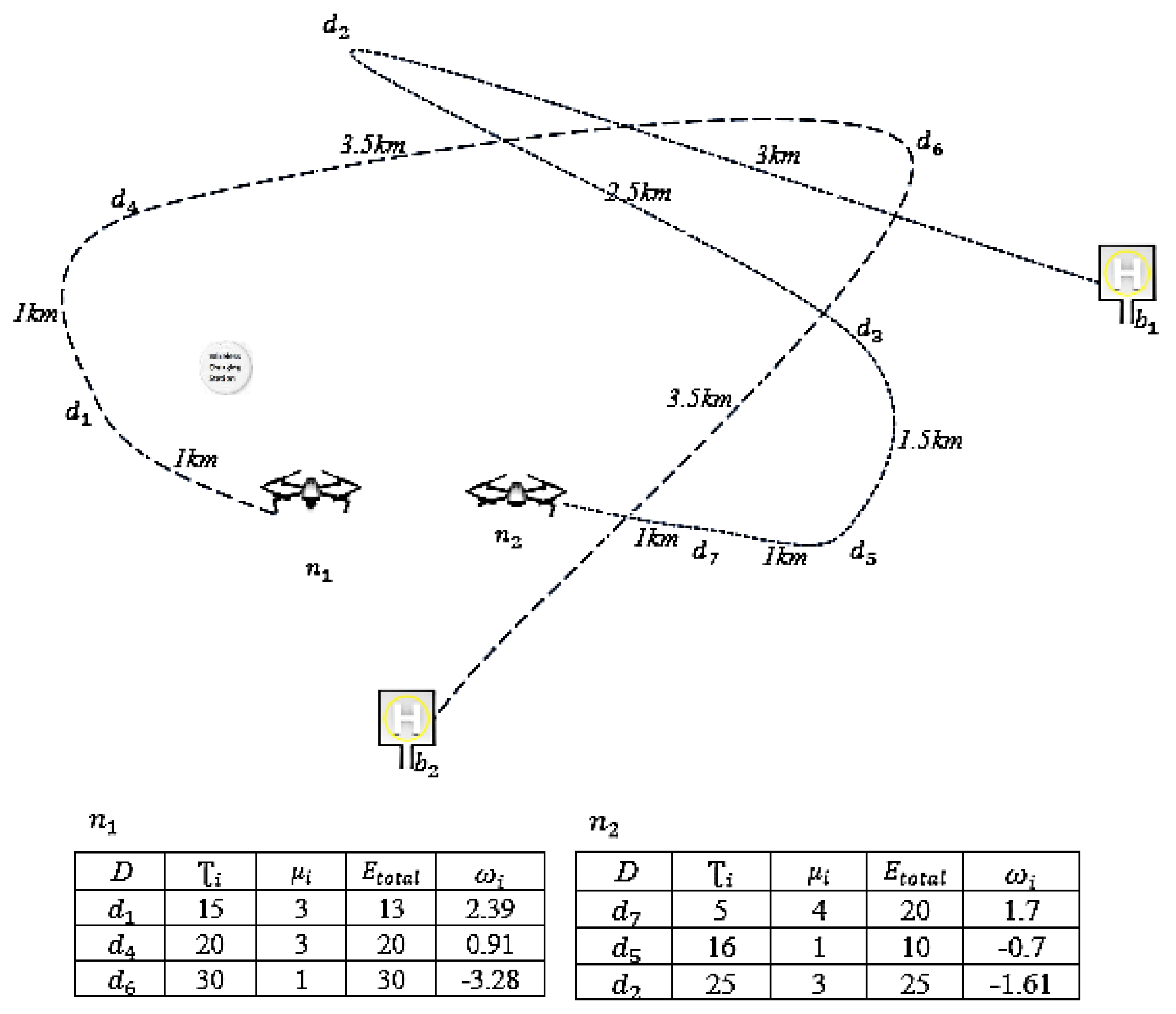
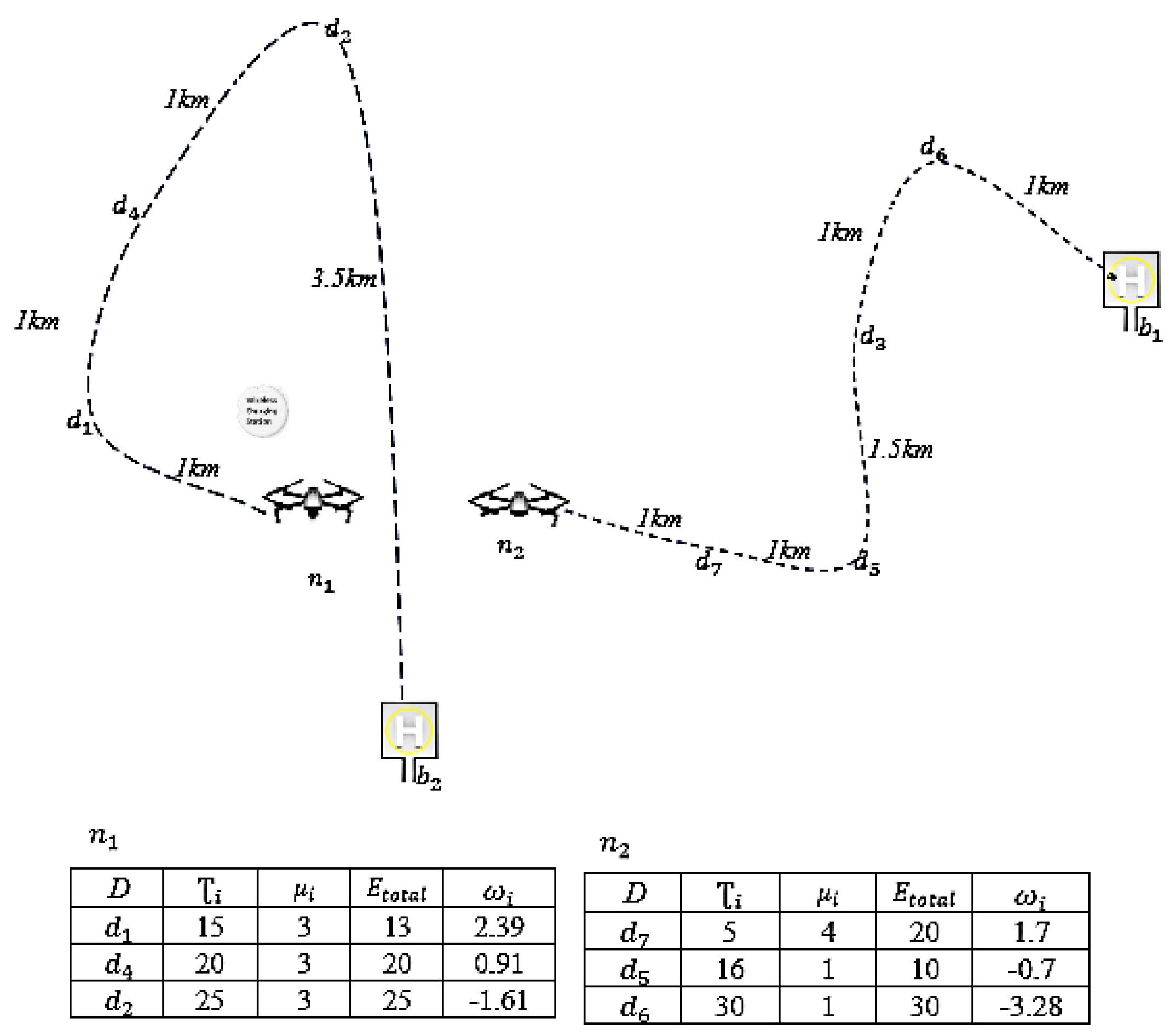
Now, let us consider the following scenario where drones and departed from and respectively. Figure 1 shows that is carrying a packet to be delivered in . However, is far away from the base and costs 3.5 km ( to ) + 3.5 km ( to ) flight to reach the base. Also, drone is carrying a packet to be delivered in that is far away from the base . As we see in Figure 2, when the summary of exchange packets in the pool is considered, the packet with destination that has the maximum weight is involved in TSP solver of both drones. The TSP outcome reveals that the delivery delay is smaller if the packet with destination is carried by . This is because has a shorter distance to . The next destination selection by drones is with the weight of 1.7, that due to the shorter distance to , it will be added to its route. By completing the selection process, we see that these drones only exchange two packets with destination and that results 2.5 km and 3.5 km less travel for drones and respectively.
We should also point out that the algorithm calculates the maximum length that a drone can fly. Hence, if a drone wishes to deliver a packet but it may run out of battery, the algorithm tries to find the nearby charging station with respect to the current flight path. Hence, the drone will get the chance to be charge for a short period to deliver more data packets. In our algorithm, we only include the charging station along as part of the route only if the distance to charging station with respect to the original flight path is not more than 1 km.
5. Evaluation
The performance of intermittent networks is highly dependent on the nodes’ mobility pattern. However, in current vehicular intermittent networks, nodes do not change their mobility behavior. This makes sense as changing mobility pattern costs vehicles too much. But given in the new drone network, energy costs are so minimal, for the first time, we can consider changing the mobility pattern to improve delivery ratio and reduce delay. We compare HFPP with two DTN routing protocols called Epidemic [8] and EBR [11], and a similar path planning method [16], using a java-based simulator called ONE [17]. The objective of such a comparison is to consider the impact of path planning on data delivery and energy inefficiency in a logistics application. For data delivery, the considered logistics network creates an opportunistic data network where only DTN routing protocols may work efficiently. Hence, we compare HFPP with other well-known DTN routing protocols. Please note, HFPP is the only approach that has inter-node communications as well as modifying nodes’ path. Hence, we could not find any similar approach to compare with. However, we demonstrate that changing drones’ mobility pattern can have minimum impact on the performance of a logistics network while a high performance is achieved in terms of data delivery compared with other routing protocols. Furthermore, we will show the importance of drones’ density in such comparison. We also show the energy inefficiency that HFPP imposes to the network.
Briefly, in Epidemic routing protocol, packets are flooded throughout the network and in EBR, the number of replicas is limited and a forwarding strategy is taken upon contacts. In [16], a greedy search algorithm simply finds the closest next way point and establish the flight path. We would like to point out that [16] was the only work related to our work though it does not support inter-drone communications.
In the simulations, we consider a disjointed network of drones that are placed randomly on a field of size 10 × 10 km2. We model the new generation of drones that have the capability of carrying up to 5 kg load. The weight of the drone with no load is 4.9 kg and moves at a speed of 100 km/h. Every drone is fully charged at the base station with 2000 k J of energy that allows it to fly at the maximum distance of 100 km. Drones are equipped with GPS and a typical Wi-Fi using IEEE 802.11 g with a radio range of 70 m and the data transmission rate is set to 54 Mbps. We also assume that the geographical location of registered destinations is known to drones. Moreover, during a contact period, drones will stay in the communication range until the process of packet exchange is fully completed. Also, each drone generates a data packet with a different size every 60 s.
In our evaluations, we assume that the number of destinations is fixed to 50, and the number of drones varies between 50 and 250. This will give us a very important insight of how increase in the number of drones for dropping of packages will impact on data network performance. We have achieved interesting results of this experiment. In all these scenarios, we assume different deadlines for consignment delivery to consider how it affects the flight path and the delay of data delivery.
We use the following metrics in our evaluation: (i) delivery ratio which is the ratio of the number of delivered packets to the number of generated packets, (ii) average data delivery delay which is the average delay that every delivered packet experience, (iii) overhead ratio which is ratio of number of delivered packets and number of relayed drones, (iv) average consignment delivery delay which is the average of time that a consignment is delivered, and (v) Energy Inefficiency which is the energy consumption’s difference between direct and detour distance. We also show how the priority of packets influences their delivery ratio and delivery delay.
5.1. Results
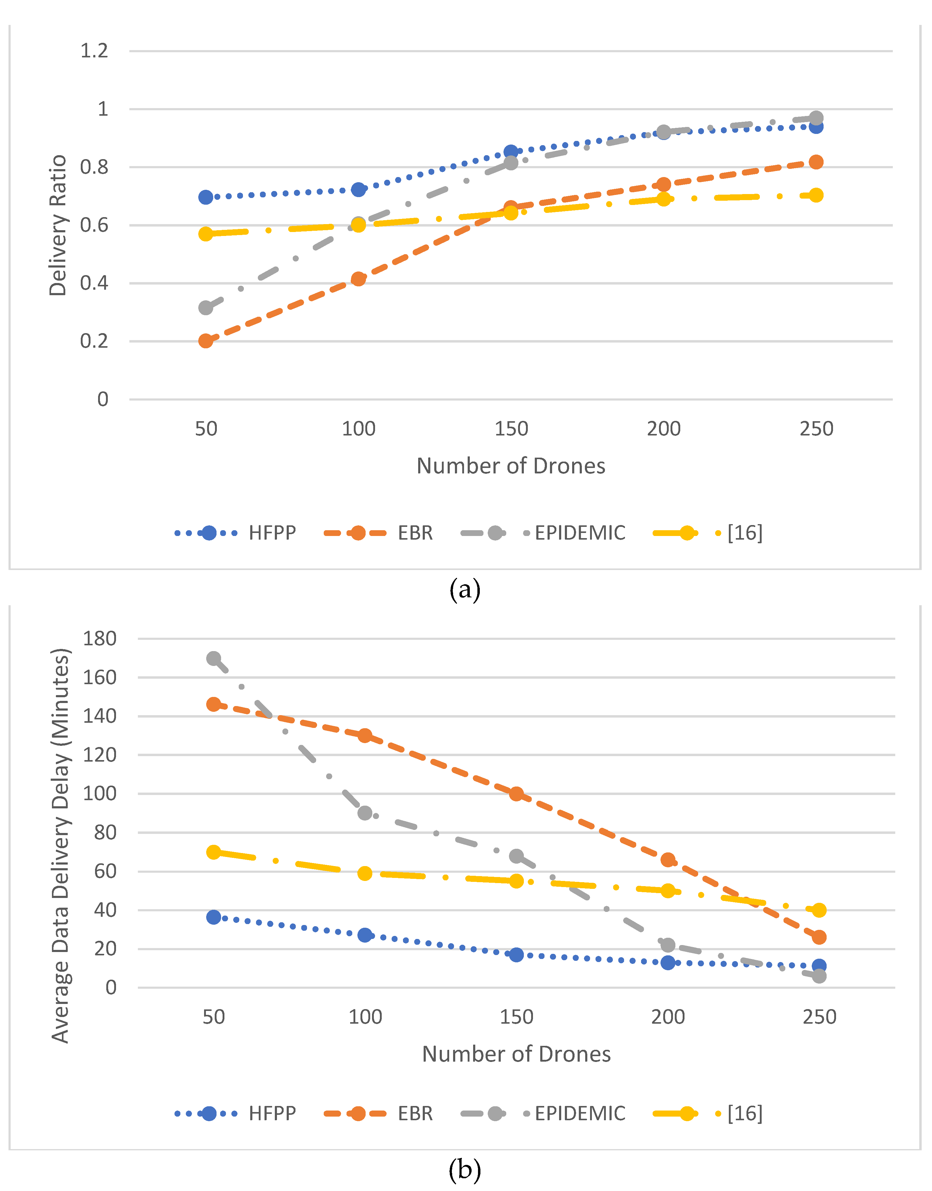
In this experiment group, the number of destinations is fixed to 50 and the number of drones varies from 50 to 250. Figure 3a shows that in terms of data delivery ratio, HFPP performs better than the comparable methods in low and high node density. As shown, by increasing the node density, Epidemic improves the delivery ratio logarithmically. This is because drones will have a higher chance to meet each other. Consequently, delays sharply reduce in high node density scenario (See Figure 3b). It is also clear that HFPP achieves minimum delay as shorter paths deliver the data packets quicker.
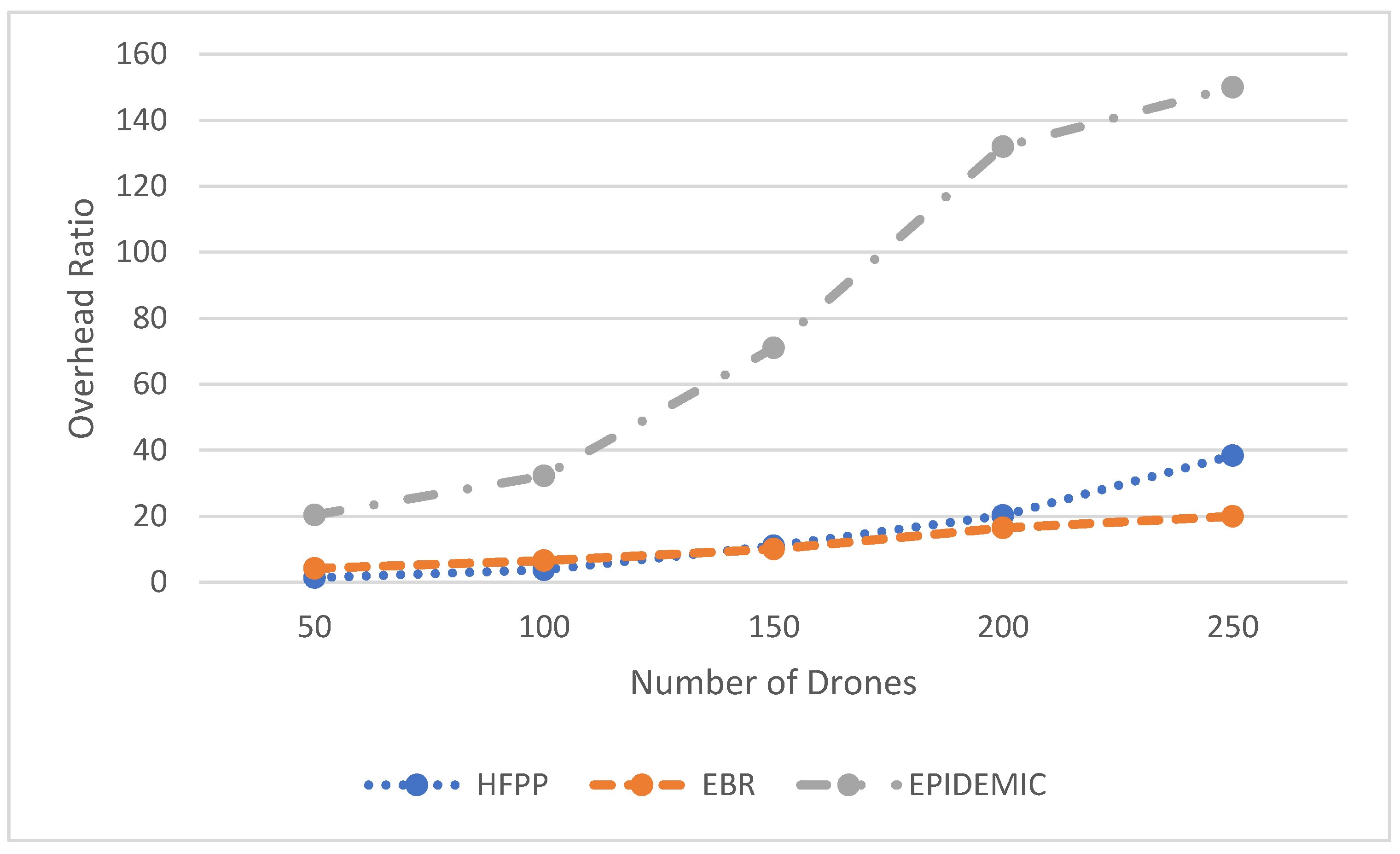
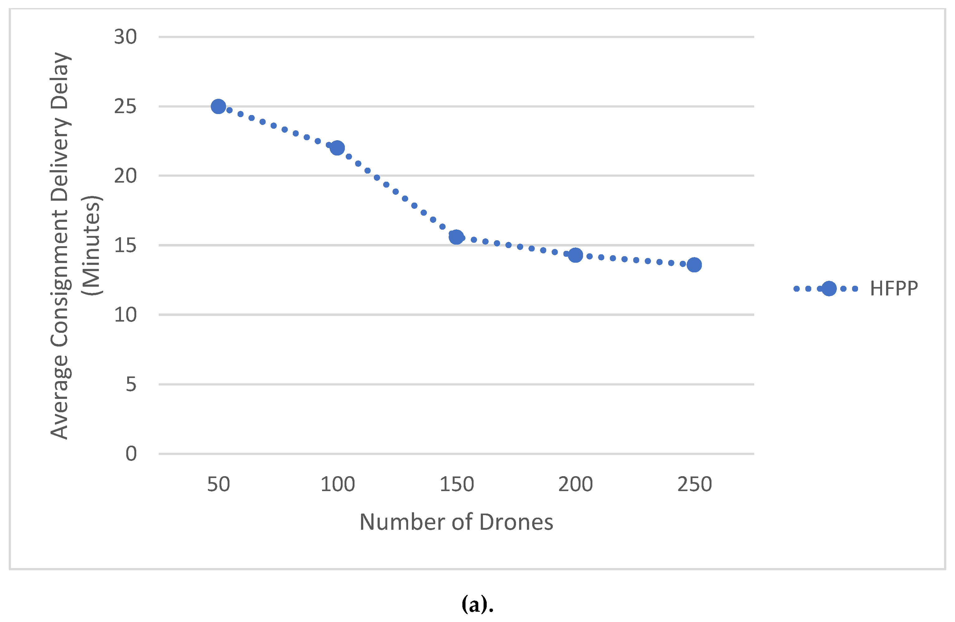
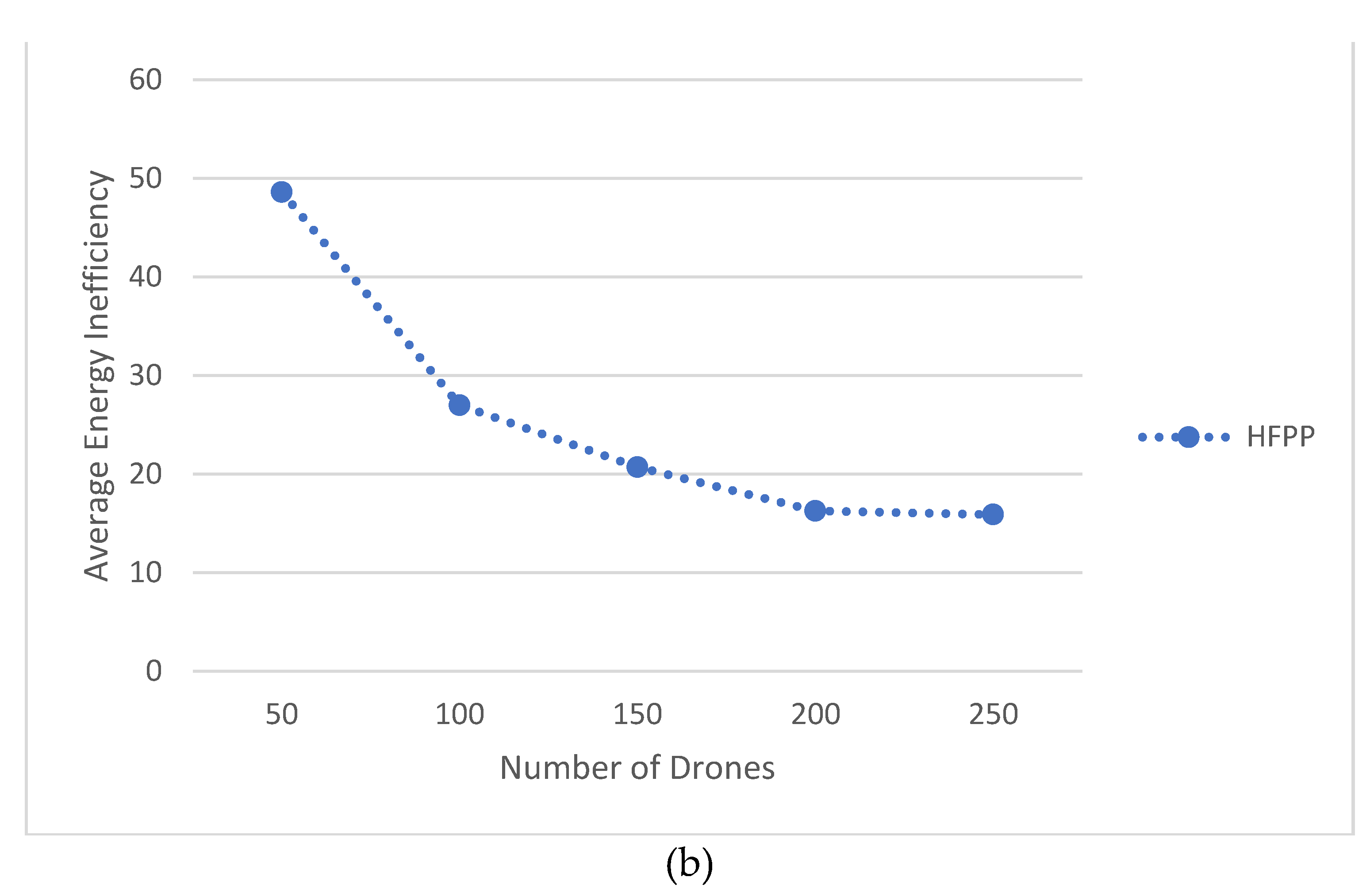
In terms of overhead, Figure 4 illustrates that HFPP has a low ratio, however, by increasing the number of nodes, the number of contact increases and the data packets will have more chance to be exchanged and become closer to the destination. Figure 5a shows that HFPP reduces the consignment delivery delay when the number of drones increases. This is because data packets will be quickly hosted at the best drone which is closer to the destination. Hence, drones will less likely modify their path frequently. This argument is proved by considering Figure 5b that shows in high node density, the average energy inefficiency sharply drops which is due to the establishing optimized path when data packets can be quickly hosted in the closest drone to the destination.
5.2. Discussion
The above simulation studies reveal that HFPP outperforms other compared methods. HFPP, due to the inter-drone communication, can route the data packets through multiple hops whereas [16] is a single hop approach. Moreover, [16] does not cover long-distance waypoints as drones are not assumed to re-charge their battery. HFPP can be considered as a routing protocol in the same way as EPIDEMIC and EBR and exchanges data packets upon opportunistic contacts. However, with HFPP only single a copy of each data packet exists. The results show that when the drones’ density is low, HFPP outperforms these routing protocols and this is because the probability of contacts is low. However, by increasing the drones’ density, Epidemic performance is similar to HFPP though the overhead is massive. Hence, HFPP can be very useful in such logistics networks as the drones’ density cannot be high in a real-world scenario. In addition, HFPP is the only approach that considers inter-node communications and modifying the mobility pattern.
6. Conclusions
This paper presented a novel approach to intelligent transportation system and data communications where well-known retail companies such as Amazon, UPS, and Dominos are focusing on providing a data delivery service on top of the drone logistics network. Heuristic Flight Path Planning (HFPP) considers the data packet’s priority, time to live, and energy consumption for the transmission to weight them. Accordingly, the destination of high weighted packets is added to the drone’s flight path such that a minimum energy inefficiency is achieved through a modified TSP solver. In the case of needing more energy to meet more waypoints, as long as the consignment delivery is not overdue, the drone can add the nearby wireless charging station to the flight path to refill the necessary energy to complete the trip. The results show that HFPP delivers up to 33% more packets against comparable methods. Also, HFPP reduces data delivery delays up to 85% while keeping the overhead in low ratio.
Author Contributions
S.I. and R.R. worked on the conceptualization and methodology. S.I. worked on software, formal analysis, visualization, writing the original draft and data curation. R.R. supervised the project and the administration. R.R. also investigated the performance of the model followed by the resources, and review and editing the final draft.
Funding
This research received no external funding.
Conflicts of Interest
The authors declare no conflict of interest.
References
- Wu, D.; Regan, A.C.; Venkatasubramanian, N. ADDSEN: Adaptive data processing and dissemination for drone swarms in urban sensing. IEEE Trans. Comput. 2016, 66, 183–198. [Google Scholar] [CrossRef]
- Fadlullah, Z.M.; Takaishi, D.; Nishiyama, H.; Kato, N.; Miura, R. A dynamic trajectory control algorithm for improving the communication throughput and delay in UAV-aided networks. IEEE Netw. 2016, 30, 100–105. [Google Scholar] [CrossRef]
- Krishnamoorthy, K.; Casbeer, D.; Pachter, M. Minimum time UAV pursuit of a moving ground target using partial information. In Proceedings of the IEEE International Conference on Unmanned Aircraft Systems (ICUAS), Denver, CO, USA, 9–12 June 2015. [Google Scholar]
- Yanmaz, E.; Yahyanejad, S.; Rinner, B.; Hellwagner, H.; Bettstetter, C. Drone networks: Communications, coordination, and sensing. Ad Hoc Netw. 2018, 68, 1–15. [Google Scholar] [CrossRef]
- Desjardins, J. Business Insider. Available online: https://www.businessinsider.com/amazon-and-ups-are-betting-big-on-drone-delivery-2018-3/?r=AU&IR=T (accessed on 3 November 2018).
- Louw, D.B.; Silk, R.J. Trigger Agents in Video Streams from Drones. U.S. Patent 9,714,089 B1, 25 July 2017. [Google Scholar]
- Thomas, A.; Raja, G. FINDER: A D2D based critical communications framework for disaster management in 5G. Peer-to-Peer Netw. Appl. 2018, 1–12. [Google Scholar] [CrossRef]
- Vahdat, A.; Becker, D. Epidemic Routing for Partially-Connected Ad Hoc Networks; Duke University: Durham, NC, USA, 2000. [Google Scholar]
- Lindgren, A.; Doria, A.; Schelén, O. Probabilistic routing in intermittently connected networks. ACM Int. Symp. Mob. Ad Hoc Netw. Comput. Mob 2003, 7, 19–20. [Google Scholar] [CrossRef]
- Iranmanesh, S.; Raad, R.; Chin, K.W. A novel destination-based routing protocol (DBRP) in DTNs. In Proceedings of the IEEE International Symposium on Communications and Information Technologies (ISCIT), Goldcoast, Australia, 2–5 October 2012. [Google Scholar]
- Nelson, S.C.; Bakht, M.; Kravets, R. Encounter–based routing in DTNs. In Proceedings of the IEEE INFOCOM, Rio de Janeiro, Brazil, 19–25 April 2009. [Google Scholar]
- Iranmanesh, S.; Chin, K.-W. A novel mobility-based routing protocol for semi-predictable disruption tolerant networks. Springer Int. J. Wirel. Inf. Netw. 2015, 22, 138–146. [Google Scholar] [CrossRef]
- Raheel, M.S.; Iranmanesh, S.; Raad, R. A novel energy-efficient video streaming method for decentralized mobile ad-hoc networks. Elsevier Pervasive Mob. Comput. 2017, 40, 301–323. [Google Scholar]
- Iranmanesh, S. A novel queue management policy for delay-tolerant networks. EURASIP J. Wirel. Commun. Netw. 2016, 2016, 88. [Google Scholar] [CrossRef]
- Iranmanesh, S.; Raad, R.; Raheel, M.S.; Tubbul, F. Novel DTN mobility-driven routing in autonomous drone Logistics networks. IEEE Trans. Veh. Technol. 2019. submitted. [Google Scholar]
- Giannini, C.; Shaaban, A.A.; Buratti, C.; Verdone, R. Delay Tolerant networking for smart city through drones. In Proceedings of the IEEE International Symposium on Wireless Communication Systems (ISWCS), Poznan, Poland, 20–23 September 2016. [Google Scholar]
- Keränen, A.; Ott, J.; Kärkkäinen, T. The one simulator for DTN protocol evaluation. In Proceedings of the SIMUTools ‘09: Proceedings of the 2nd International Conference on Simulation Tools and Techniques, Rome, Italy, 2–6 March 2009. [Google Scholar]
- Yang, P.; Tang, K.; Lozano, J.A.; Cao, X. Path planning for single unmanned aerial vehicle by separately eving waypoints. IEEE Trans. Robot. 2015, 31, 1130–1146. [Google Scholar] [CrossRef]
- Zheng, C.; Li, L.; Xu, F.; Sun, F. Evolutionary route planner for unmanned air vehicles. IEEE Trans. Robot. 2015, 21, 609–620. [Google Scholar] [CrossRef]
- Nikolos, I.K.; Valavanis, K.P.; Tsourveloudis, N.C.; Kostaras, A.N. Evolutionary algorithm based offline/online path planner for UAV navigation. IEEE Trans. Syst. Man Cybern. 2003, 33, 898–912. [Google Scholar] [CrossRef] [PubMed]
- Nikolos, I.K.; Tsourveloudis, N.C.; Valavanis, K.P. Valavanis, Evolutionary algorithm-based path planning for multiple UAV cooperation. Springer Adv. Unmanned Aer. Veh. 2007, 33, 309–340. [Google Scholar]
- Zhang, X.; Duan, H. An improved constrained differential evolution algorithm for unmanned aerial vehicle global route planning. Appl. Soft Comput. 2015, 26, 270–284. [Google Scholar] [CrossRef]
- de la Cruz, J.M.; Besada-Portas, E.; Torre-Cubillo, L.; Andres-Toro, B.; Lopez-Orozco, J.A. Lopez-Orozco, Evolutionary path planner for UAVs in realistic environments. In Proceedings of the 10th Annual Conference on Genetic and Evolutionary Computation, Atlanta, GA, USA, 12–16 July 2008. [Google Scholar]
- Sujit, P.B.; Beard, R. Multiple UAV path planning using anytime algorithms. In Proceedings of the American Control. Conference, Missouri, MO, USA, 10–12 June 2009. [Google Scholar]
- Szczerba, R.J.; Galkowski, P.; Glicktein, I.S.; Ternullo, N. Robust algorithm for real-time route planning. IEEE Trans. Aerosp. Electr. Syst. 2000, 36, 869–878. [Google Scholar] [CrossRef] [Green Version]
- Zhang, S.; Zhang, H.; Di, B.; Song, L. Cellular controlled cooperative unmanned aerial vehicle networks with sense-and-send protocol. IEEE Int. Things J. 2018, 6, 1–13. [Google Scholar]
- Mosheiov, G. The travelling salesman problem with pick-up and delivery. Eur. J. Oper. Res. 1994, 79, 299–310. [Google Scholar] [CrossRef]
- Stolaroff, J.K.; Samaras, C.; O’Neill, E.R.; Lubers, A.; Mitchell, A.S.; Ceperley, D. Ceperley, Energy use and life cycle greenhouse gas emissions of drones for commercial package delivery. Nat. Commun. 2018, 409, 9. [Google Scholar]
- Salarian, H.; Chin, K.-W.; Naghdy, F. An energy efficient mobile sink path selection strategy for WSNs. IEEE Trans. Veh. Technol. 2014, 63, 2407–2419. [Google Scholar] [CrossRef]
- Kreyszig, E. Advanced Engineering Mathematics, 2nd ed.; Wiley: New York, NY, USA, 1979; p. 880. [Google Scholar]
- ohnson, D.S.; Gutin, G.; McGeoch, L.A.; Yeo, A.; Zhang, W.; Zverovitch, A. Experimental analysis of heuristics for the ATSP. In The Traveling Salesman Problem and Its Variations. Combinatorial Optimization; Springer: Boston, MA, USA, 2007; pp. 445–487. [Google Scholar]
Figure 1.
Original flight paths of two drones.

Figure 2.
Optimized flight paths of the two drones in Figure 1 based on Heuristic Flight Path Planning (HFPP).
Figure 2.
Optimized flight paths of the two drones in Figure 1 based on Heuristic Flight Path Planning (HFPP).

Figure 3.
(a) delivery ratio of comparable schemes, (b) average data delivery delay of comparable schemes, when number of drones varies.
Figure 3.
(a) delivery ratio of comparable schemes, (b) average data delivery delay of comparable schemes, when number of drones varies.

Figure 4.
Overhead ratio of comparable schemes when number of drones varies.

Figure 5.
(a) Average consignment delivery delay, and (b) average energy inefficiency, of HFPP when number of drones varies.
Figure 5.
(a) Average consignment delivery delay, and (b) average energy inefficiency, of HFPP when number of drones varies.


Table 1.
Summary of notations.
| Variables | Description |
|---|---|
| set of v drones | |
| vth drone | |
| set of q destinations | |
| qth destination | |
| set of b bases | |
| mth base | |
| set of k wireless charging stations | |
| kth wireless charging station | |
| Maximum flight duration that means drone i should be at the origin base after that | |
| maximum flying distance | |
| Degree of packet i’s importance | |
| Packets i’s time to live | |
| S | Speed of drone |
| R | Radio range of drone |
© 2019 by the authors. Licensee MDPI, Basel, Switzerland. This article is an open access article distributed under the terms and conditions of the Creative Commons Attribution (CC BY) license (http://creativecommons.org/licenses/by/4.0/).
Share and Cite
MDPI and ACS Style
Iranmanesh, S.; Raad, R. A Novel Data Forwarding Strategy for a Drone Delay Tolerant Network with Range Extension. Electronics 2019, 8, 659. https://doi.org/10.3390/electronics8060659
AMA Style
Iranmanesh S, Raad R. A Novel Data Forwarding Strategy for a Drone Delay Tolerant Network with Range Extension. Electronics. 2019; 8(6):659. https://doi.org/10.3390/electronics8060659
Chicago/Turabian StyleIranmanesh, Saeid, and Raad Raad. 2019. "A Novel Data Forwarding Strategy for a Drone Delay Tolerant Network with Range Extension" Electronics 8, no. 6: 659. https://doi.org/10.3390/electronics8060659
Note that from the first issue of 2016, this journal uses article numbers instead of page numbers. See further details here.