Seasonal Migration and Settlement around Lake Chad: Strategies for Control of Resources in an Increasingly Drying Lake

1
Department of Geography, Higher Teachers’ Training College, University of Maroua, Maroua, BP 55, Cameroon
2
Lund University Centre for Sustainability Studies—LUCSUS, Biskopsgatan 5, SE-223 62 Lund, Sweden
*
Author to whom correspondence should be addressed.
Resources 2017, 6(3), 41; https://doi.org/10.3390/resources6030041
Submission received: 27 March 2017
/
Revised: 20 August 2017
/
Accepted: 21 August 2017
/
Published: 25 August 2017
(This article belongs to the Special Issue Toward Integrated Water-Energy-Land-Food Management)
Abstract
:The Lake Chad Basin has for a very long period supported the livelihoods of millions of peoples from the different countries that share this transboundary water resource. Its shrinking over the decades has meant that many of those who depend on it for livelihoods would have to adjust to the changing resource environment of this lake basin. This study sets out to examine the seasonal migration of people in search of water, pasture, fuelwood and cultivable land, and how this movement affects access and use of basin resources. The study made use of survey data obtained from 220 household heads on the Cameroon side of the Lake Chad basin, and secondary data from Cameroon ministries in charge of agriculture, the environment, and that of livestock. Our findings show that while fishing and livestock rearing continue to feature among the oldest determinants of population movements in the Lake Chad basin, increasingly the search for new farming opportunities made available by a shrinking lake and the political instability emanating from Nigeria are also becoming an important determinant. The increasing population in the lake region is compounding pressures created by a shrinking lake on access to water, fuelwood, pasture, and farmland. While there is potential to develop and benefit from the agricultural possibilities emerging from a shrinking lake, the impacts of poor agricultural resource management (especially land degradation, loss of agricultural biodiversity, and poor water management) may hamper the sustainable practice of agriculture if proper efforts are not made to address them. This study contributes to the scientific understanding of the changing nature of environmental resources in Africa. It specifically contributes to understanding the exacerbating threats to the sustainability of natural resources (water, agricultural and grazing land) caused by environmental changes, diversification of rural actors (fishers, farmers, breeders), weak resource management, and since 2013, by an armed conflict.
1. Introduction
Lake Chad is the centerpiece of critical socioeconomic and ecological activities within a transboundary zone surrounded by four countries—Cameroon, Chad, Niger, and Nigeria. Ecologically, the lake contributes to the hydrological dynamics of the transboundary zone in which it is located [1]. It has also been home to endemic biodiversity in the Sahel. Lake Chad has been serving as the source of valuable economic resources in the region. These include the lake water and its tributaries used for consumption; grasses around the lake shores and intertidal zones used as fodder, as well as raw materials for handicraft industries. Fish remain the key economic resource and is a source of protein for millions of people that depend on it [1,2,3]. The lake is also an important economic resource for the Sahelian population in the four countries that surround it. Historically, it has always played a central role in the trans-Saharan trade. It is an important meeting place between socio-economic actors in different sectors of economic and social life.
Migration is defined as “any residential movement which occurs between administrative units over a given period of time” [4]. Other definitions have made use of the “center of gravity” approach in understanding human migrations [5]. These approaches define migration as the change in the center of gravity of an individual’s mobility pattern. They specify that the destinations of the mobility flows need not in themselves change as a result of the change in their center of gravity [5]. Boyle et al. [6] points to the need to make a distinction between movements which have a sense of permanency and involves displacements to generally ‘distant’ places, from those with a temporal character involving generally short distances. The meanings of ‘long’, ‘short’, ‘temporary’ or ‘permanent’ may vary depending on the context. Nonetheless, the former (permanent displacement involving long distances) could qualify as migration, while the latter (temporal displacement over short distances) rather qualifies as ‘residential mobility’ [7].
Sinclair and Fryxell [8] explained the human-nature interactions in the Sahel and the history of activities that gave birth to the cycles of famine that have become synonymous with food and other resource insecurities in the Sahel. The balance between human population and natural sources in African Sahel has been described as precarious, and in need of careful management, if sustainable outcomes are to be achieved [1,9,10,11]. For a long time, human population in this region have been sustained by seasonal migrations to sources of nutritious food and cattle grazing grounds. It has been argued that as a result of such movements, the African Sahel has managed to sustain a higher population size than they could as sedentary populations [10,12,13]. Through centuries of practice, migratory pastoralists have managed to sustain their cattle numbers and migratory practices in balance with the vegetation. The precarious nature of the ecosystem in the region came to focus in the 1950s and 1960s when the balance was disrupted by the settlement of pastoralists around wells, and the expansion of agriculture north into the herders’ grazing lands. This led to an increase in human and cattle populations which in turn triggered a loss in the land’s productivity from overgrazing and the intensive cultivation of cash crops. The cycles of famine which have become synonymous with life in Africa’s Sahel begun in 1968 and has its roots in the shift in human-nature interactions that occurred here in the 1950s and 1960s [8].
Same as gradual and extreme environmental changes, an increase in the human as well as animal populations and depending on limited resources in fragile ecosystems have the potential of increasing pressures on such resources. Such new human pressures may compound existing environmental pressures associated with phenomena such as climate change [14,15]. While the geographical extent and severity of these pressures remain unclear in the Lake Chad region, it seems likely that such combination of pressures may eventually reduce the land’s ability to sustain the agricultural, livestock, and ecosystem functions as they once did. Hunter and Nawrotzki reported that a fall in productivity resulting from the environment’s decreased ability to provide livelihood sustenance services has the potential of impacting livelihood decision-making and potentially fueling population movements [16].
The Intergovernmental Panel on Climate Change (IPCC) predicts that the African Sahel will experience an estimated 10% reduction in annual rainfall by 2050. Such a decrease in rainfall in this area with a pastoral nomadic lifestyle and seasonal rain-fed agriculture that has been developed over centuries could have substantial effects on food and water security in the region as it will be difficult to manage. Already, current changes in climate have already reduced the length of the growing season, the amount of land suitable for agriculture, and crop yields [17,18]. Yields from some major rain-fed food crops are expected to fall by up to 50% in some countries in as early as 2020 [17].
The relationship between the resources of Lake Chad and the millions of inhabitants it supports has been the focus of previous studies. Adams (1993) identified the strong dependence of populations around major wetlands in Africa (including Lake Chad) for farming, fishing, and pastoralism. Besides identifying the international importance of West African wetlands in supporting populations of wild fauna, the study also noted that development projects had the potential of contributing to negative outcomes for the ecology and economy of such wetlands [19]. Béné [20] recognized three resource management systems in the Lake Chad catchment area. Local government/community institutions are responsible for resource management in the majority of farming and fishing communities [21]. In remote locations where state and traditional powers could not access, non-legitimated agents, purporting to act on behalf of governments were illegally controlling resource access and exploitation through illegal taxation [21]. With the growth of armed groups around the lake basin, there have increasingly been areas that have been taken over by such groups, and where such groups exercise their form of rule and control over resources.
When the African World Forum on Sustainable Development met in N’Djamena, Chad, in October 2010, the declining capacity of a shrinking Lake Chad to support the estimated 30 million people that depended directly or indirectly on the lake basin’s resources was at the center of discussion [22]. Political leaders of the Lake Chad Basin Commission (LCBC) identified the shrinking of the lake as well as its declining ability to support ecosystems and livelihoods as key sustainable development and human security challenges for the region. As a result, the leaders insisted on a collective effort to save the lake. An understanding of resource dynamics in the Lake Chad basin is therefore essential, given the number of people depending directly on its resources for their livelihoods [1].
Seasonal migration of populations to make use of resources outside their immediate geographical vicinities has been a defining feature of human history, especially in environments with a limited endowment in natural resources. In the Sahel, pastoralists have been embarking on seasonal migrations to wetlands for millennia. In areas around lakes, pastoral migrants are often found around seasonally-flooded lands and wetlands when surrounding rangelands and pasture areas dry out [19]. At certain periods of the year, when grazing opportunities are limited the relatively small area of wetland around the lake, therefore, serves as a critical resource to sustain the very basis for economic life and livelihoods (cattle) for millions of people residing in a much larger area than the lake shores [19].
In the Lake Chad basin, seasonal migration and temporary settlement in areas around the lake bed are therefore strategies adopted by farmers and graziers to maximize opportunities for farming and grazing offered by the reducing lake. For fisherfolk, seasonal migration towards the increasingly distant shores of a once bigger lake seems to be the only way of sustaining access to the lake waters and the fish potentials they provide. This study contributes to the understanding of strategies for the control of resources of the drying lake. The strategies that consist of seasonal migrations and settlement will be analysed in a context characterized by the presence of several actors: breeders (pastoralist), farmers, fishers, traditional rulers (Blama) and public authorities.
Understanding the drivers and dynamics of such resource control strategies are therefore essential in building policies that respond to some of the pressing challenges of the Lake Chad basin. Such challenges include the sustainable use of lake resources, adaptation measures for global environmental challenges, and the diversification of sources of livelihood beyond direct dependence on lake resources. This study, therefore, seeks to achieve the following aims:
- Examine the nature of seasonal migration and temporary settlement in the Lake Chad basin area;
- Assess the extent to which this migration affects the access of populations to key resources supported by the lake;
- Identify relevant strategies that would support policy and practice in natural resource control/management in the context of an increasingly dry Lake.
2. Study Area
Lake Chad is located at the southern edge of the Sahara Desert and is bordered by Nigeria, Niger, Chad, and Cameroon (Figure 1). The lake was once the second-largest wetland in Africa. Its drainage basin is a hydrologically closed catchment of about 2,500,000 km2 which extends to eight countries: Algeria, Libya, Niger, Chad, the Republic of Sudan, Central African Republic, Cameroon, and Nigeria [1].
The Cameroonian zone of the lake is a part of the southern basin called small lake [23] with water for fishing and is characterized by settlements and seasonal migrations in its dry areas. Three districts that share the Cameroon portion of Lake Chad and its borders were selected for the study. These are the Blangoua, Makari, and Darak Subdivisions which administratively belong to the Logone and Chari Division in the Far North Region of Cameroon (Figure 1). These Subdivisions are located between latitudes 12°30′ and 12°45′ North and longitudes 13° and 15°45′ East (Figure 1).
Inhabitants around the lake basin have over a long period been well integrated, with strong cultural, social, and trade ties moving freely between the national borders. Over the last decade, however, the intensification of armed conflict on the Nigerian side of the border, which has seeped into the Cameroonian side, has reduced such close contacts. The environment around the lake basin is characterized by the presence of functional levee, dry beaches of the lake. From a climate perspective, it is a semi-arid area with less than 450 mm of rainfall, and with a high interannual variability. For analysis at the local level, the villages of Ndagalgui, Nanawadji, Boungour and some Fulani camps and KatikiméDarak were surveyed.
Over the last half-century, the area occupied by waters of the Lake Chad has been reducing steadily (Figure 2). Many factors account for this decline, including high population growth rates that have contributed to an increase in lake water consumption as well as the appropriation of waters from tributaries that feed the lake. The population of people around Lake Chad currently stands at 51 million in 2015 with projections that it may reach 80 million by 2030 [24]. Population increase implies an increase in demand for water resources for a variety of economic and livelihood activities [25,26]. Past demographic increases prompted investments in better and more efficient means of accessing water in this relatively dry environment. This demand led to the conversion of several artesian wells to cement wells at an individual and household level, and to the widespread drilling of boreholes for rural water supply by local and state government institutions.
All of these, combined with declining rainfall have contributed to a fall in the water level of the lake [28,29]. Rainfall variability has also been attributed to a decline in the area of Lake Chad [30]. Coe and Foley [31] as well as Gao, et al. [32] reported that since the early 1960’s, rainfall over the basin decreased significantly while irrigation (bolstered by the demographic growth) increased dramatically over the same period. It is reported that the reason why the lake has been especially vulnerable to climate variability is because of its rather shallow depth of less than 7 m [30,33]. For Lemoalle and Magrin [23], variations of the level of Lake Chad is linked to the reduction of rainfall: “The current phase of Small Chad results from the transition between a relatively wet period (1950–1970) and a phase of drought in the Sahel and on the Chari River (1970–1990), particularly increased during the dry episodes (1972–1973 and 1983–1984).” The result has been a reduction in the lake water surface of more than 90% over roughly 35 years [1,32]. This reduction is putting pressure on challenges for sustainable food production, wetland habitat conservation, water management in transboundary basins, and adaptation to climatic change [30].
3. Methods of Data Acquisition, and Analysis
3.1. Selection of the Villages and the Administration of Semi-Structured Questionnaires
This study took place over a three year period, from 2012 to 2014. In the first year 2012, the focus was on understanding local dynamics of land use and livelihood activities through observation and open interviews with randomly selected members of various communities (pastoralists, farmers, fishers) in the study area. This pilot phase involved general observation and informal interviews with some stakeholders in the natural resource use sectors. These include fishers, breeders, farmers, traditional rulers, public authorities. The questions focused on their activities and the problems of resources management in the study area. This pilot study provided an understanding of the study area that was necessary for designing the household survey that constituted the second part of the study. The household survey was carried out in 2013, and the key informant interviews were conducted in 2014, after an analysis of the survey data. The study was carried out in three administrative units referred to as “subdivisions” in the Far North Region of Cameroon. These were Hilé Alifa, Blangoua, and Darak which share the Cameroonian shores of the Lake Chad (Table 1). They are the administrative units most affected by the settlement of farmers, breeders and fishers coming from Nigeria, Niger, Chad and from other areas of Northern Cameroon. In each subdivision, villages were selected taking into account the activities of the inhabitants, and the period in which these villages were occupied, or became officially recognized (generally in the 1970s and 1980s) (Table 1). In the selected villages, a stratified random sampling was used in deciding household heads to which questionnaires were administered. A total of 220 questionnaires were administered, taking into account the three communities (fishers, breeders, farmers) (Table 1).
The questionnaires used for the survey were designed on themes that explain the seasonal migration and settlement of population in the study area. The questions systematically identified individuals based on location, then derived information that could enable the classification of respondents based on the type of primary livelihood activity (crop cultivation, pastoralism, or fishing). This was followed by contextual information on migrations, settlement, resource management, and relationships between land resource users. Hence, the questionnaires were organized as follows:
- Settlement process of migrants on the shore of Lake Chad, including year of arrival, causes of displacement from community of origin, reasons for the choice of the actual site;
- Farmers access to land including methods of land acquisition, land management techniques, and ownership rules;
- Management of pastures, including type and number of livestock, processes, and timing of transhumance activities, annual destinations of transhumance, pasture availability, pasture conflicts, and aspects of conflicts associated with activities of transhumance;
- Relationship between farmers and pastoralists.
Besides the survey of households using structured questionnaires, key informant interviews were organized with traditional authorities of the nine villages selected with the aim of further investigating some of the main themes that were derived from the structured survey. These open interviews explored the history of settlements in the surveyed villages and the evolution of different methods of access to land and use for the various livelihood activities of the region. They also provided data on the management of natural resources (dry lands for agriculture, pastures, and water), and the relationships (conflicts, and rules) between different key stakeholders (farmers, breeders, and fishers). The open interviews with traditional authorities were performed using discussion guides.
3.2. Secondary Sources of Information
Annual reports of government ministerial services were used for the collection of data on agriculture, livestock, and fishing. Data on crop production was derived from the local services of Ministry of Agriculture and Rural Development (MINADER). Reports produced by this ministry also contain data on some of the problems faced by agriculturalists in the region. An example of such problems reported by the data is land conflicts. Such data were used to complement field data collected through questionnaires. Data on livestock numbers and their movements are available in the annual reports of Ministry of Livestock, Fishing and Animal Industries (MINEPIA). These data provided near consistent information that dates back to 1994, especially on cattle and sheep. Some information about the destinations of pastoralists and the transhumance routes were gathered from these reports and complemented with data collected from the field. Data from the second (1987) and the third General Population and Housing Census of Cameroon (2005) completed by data survey were used to examine the history of the spatial and demographic dynamics around Lake Chad—particularly the evolution of populations of the three subdivisions and nine villages (Table 1).
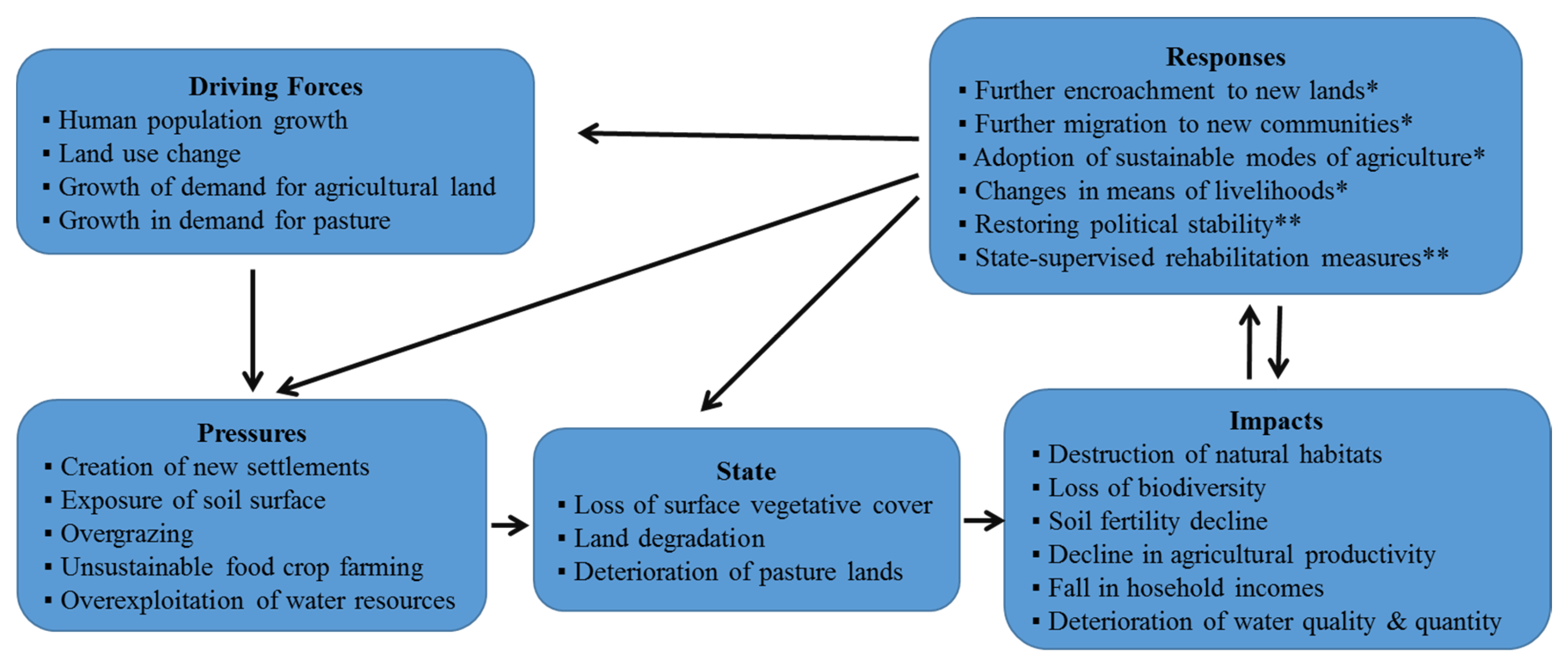
3.3. The Drivers, Pressure–State–Impact–Response, (DPSIR Framework)
We consider the Driving Force-Pressure-State-Impact-Response (DPSIR) as an appropriate tool to analyze the relationship between economy and environment, especially in the case of the Lake Chad. The Driving Force-Pressure-State-Impact-Response (DPSIR) is a framework developed by the European Environment Agency for describing the interactions between society and the environment [34,35]. Driving forces (D) refer to needs, which could include primary driving forces for an individual’s need (for example, shelter, food, and water), and secondary driving forces (such as mobility, entertainment, and culture) [35,36]. Primary driving forces for needs in an industrial sector could be the need to increase profitability, while at a national level, the creation of employment may be important. All of these needs contribute to shaping human activities that have a direct impact on the environment. Pressures (P) include specific human activities that result from driving forces as well as the natural processes that have a similar impact on the environment [36]. State (S) is the condition of the environment (air, water, soil, etc.) resulting from the pressures to which it is subjected. The “state” of the environment is, therefore, the combination of the physical, chemical and biological conditions that determine the functions that these compartments fulfill. These states may not necessarily be static, but rather reflect current environmental trends. Impacts (I) are the ways in which changes in state influence human well-being. Impacts may be positive or negative. Responses (R) refer to institutional endeavors to address alterations in state, as prioritized by Impacts. A ‘response’ is usually undertaken by society or policy makers [36], and is the result of an undesired impact and can affect any part of the chain between driving forces and impacts.
4. Results and Discussion
4.1. Fishing as a Significant but Declining Pull Factor to the Lake Area
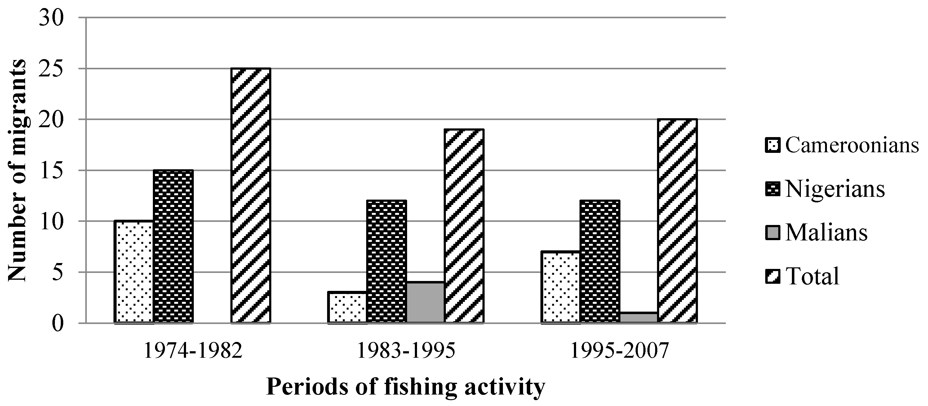
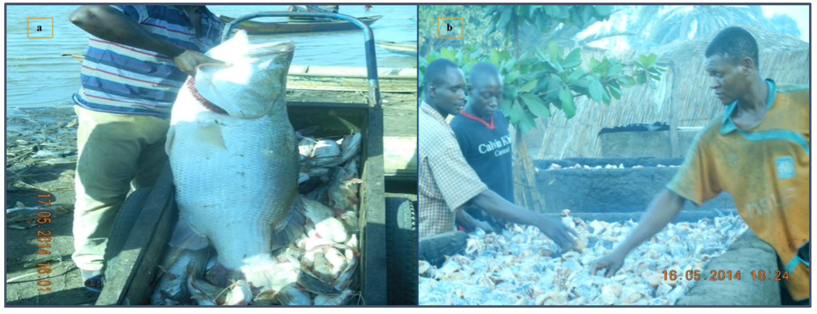
Lake Chad is one of the oldest settlement basins of Central Africa. Opportunities for exploiting the region’s fishing potentials have been, which has until recently, been the main attraction for migration to the basin. Besides local communities, migrants from other Cameroonian localities a little south of the lake have been fishing in the lake on a seasonal basis. These are the Musgum, Kotoko or Hausa traditional fishermen from Pouss, Zina, and Mora. Since the 1970s, international migrants from Mali, Senegal, Niger, and Nigeria have been occupying and fishing in many of the lake’s islands (Figure 3). An example of the role of foreign fishers in the contribution to fishing in Cameroonian waters can be demonstrated through the case of the island of Darak. Here, domestic and foreign fishers have contributed to making fishing an important economic activity (Figure 4).
Between 1974 and 1982, Nigerian and Cameroonian fishers were the first wave of immigrants to settle in Darak. Since 1983, others nationalities (Mali, Niger, Burkina Faso) began their settlement. Since 2007, immigration to the lake area exclusively for fishing as an economic activity has been declining. Nevertheless, in 2008, Darak was producing more than 200 tons of fish annually [37].
The settlement of migratory population in the Lake Chad area contributes to increasing population pressure on local resources. Population pressure increases problems that are brought about by the shrinking of the lake on local livelihoods. This has been particularly evident among the fishing communities who still have to depend on fishing from a shrinking lake as a main means of livelihood. Members of the fishing community reported that fishing-dependent livelihoods have been witnessing a reduction in the fish catch which is the main source of their livelihood.
The local population reported that the need to escape environmental constraints in surrounding regions was also an important contributor to their decisions on seasonal migrations into the Lake Chad area. This has contributed to increasing reliance on resources of the Lake Chad basin for the livelihoods of people affected by these pressures. This is the case with the repeated droughts in the Sahel in the 1970s and 1980s. The waters, wetlands, and fish of the basin offered potentials for populations to exploit through activities such as fishing, cattle rearing, crafts, and a range of supporting services. The lake and its associated resources have therefore continued to provide a seasonal mitigation of the potential consequences of such environmental constraints to many people living in and around the lake’s vicinity: water and pasture for pastoralists; source of protein and income to fishers; raw materials for crafts making to artisans; etc.
4.2. Changes in the Character of Seasonal Transhumance
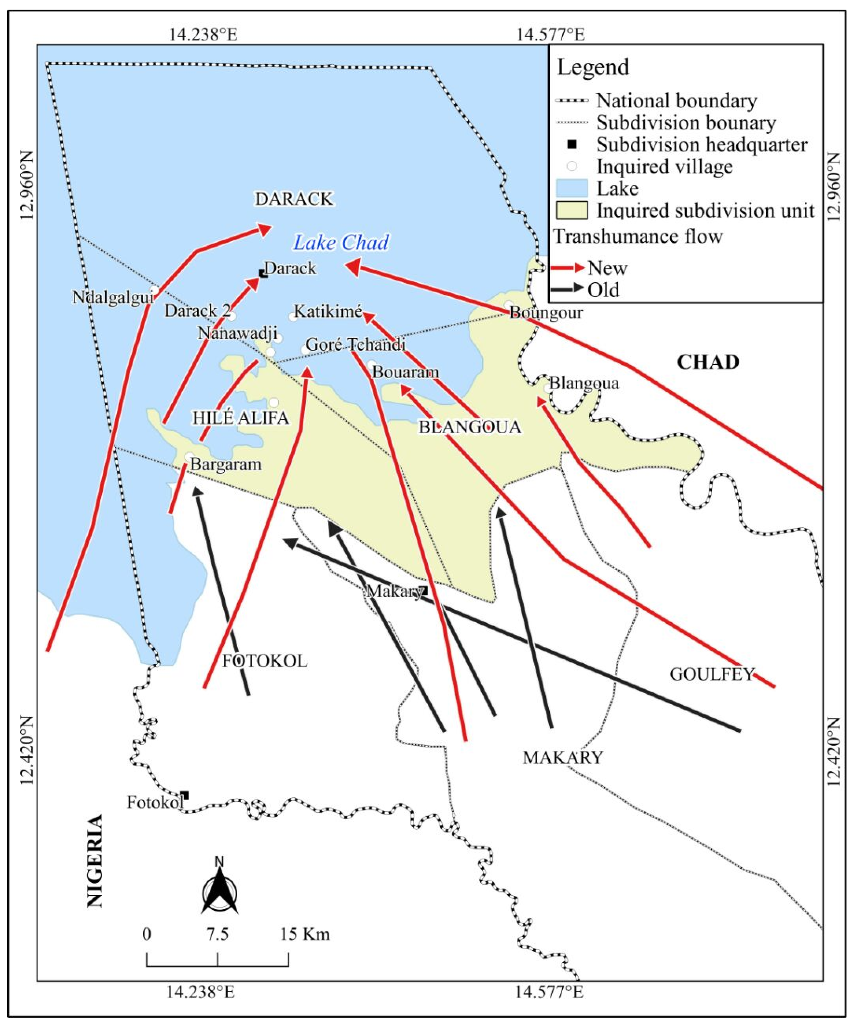
In recent decades the shrinking of Lake Chad has been opening up opportunities beyond fishing. With shifts in the configuration and extent of its shoreline, transhumance routes and camp sites have had to change in response. Figure 5 shows the changes that these routes have had to undergo to ensure that pastoralists continue to access pastures bordering the lake. These changes have been substantial. Since 2007, the practice of pastoralism in the Blangoua, Makari, Fotokol, Goulfey and Hile Alifa Sub-divisions located in northern Logone Birni has drastically declined in favor of Darak Sub-divisions where new grassland shorelines are being opened on parts bordering the lake. According to the government Delegation of Livestock, Fisheries, and Animal Industries for the Logone and Chari, about 45,000 cattle and 9000 sheep are brought into the administrative division within the context of the practice each year. Increasingly, and as a result of environmental problems being compounded by political unrests in the region, these herdsmen are choosing to settle in the region permanently.
Before 1986, the community of Logone Birni, located below the 12○N has rated the last and the most remote community for transhumance routes for cattle herders from Fotokol, Makary, and Goufley [38].
4.3. Growth in the Practice of Off-Season Agriculture
Unlike fishing and livestock rearing, off-season agriculture is an activity that has witnessed a substantial expansion on the shores of Lake Chad. As the lake shrinks, an area of land rich in silt, and wet all year-round than surrounding areas is increasing around the dwindling lake. The yields derived from cultivating these emerging landscapes are high, and this has in recent years been a pull factor for immigration into the region. Groups of migrants are neither traditional fisherfolk nor herdsmen (the primary activity that has dominated economic life in the region in the recent past). Those that practice crop cultivation as the main livelihood activity reported that they are attracted to the region by the potentials of better yields for both traditional (sorghum and millet) and non-traditional food crops (maize and flood rice). Maize is the main off-season cereal crop—cultivated in about 22,000 hectares of land and achieving a total production of 44,000 tons in 2012. Unlike other areas of the region which dry out during the dry season, in the areas emerging from the shrinking lake, the dry season has become a major food crop growing season. Seasonal migration of crop producers into the lake area during the dry season has therefore increased to take advantage of the farming opportunities. Hence, the period of agricultural production has been extended substantially as the dry season is now extended into the rainy season which is the traditional crop growing season in the region. However, the local population is already reporting an increase in population pressure on farming and grazing lands emerging from the lake. This pressure also includes pressure on associated land resources required to support local livelihoods. Examples of such resources include fuelwood and a host of wild grassland non-wood resources. The competition for land resources is resulting in conflicts between members of different communities and economic sectors. Earlier studies already identified the potential for such conflicts as environmental conditions change [15]. Cumulative data on the number and causes of conflicts of conflicts reported by the people over the last decade from the three districts of Darak, Blangoua and Hilé Alifa is presented in Table 2.
4.4. New Community Tensions over Natural Resources
Given the transnational nature of Lake Chad and its basin area, the impact of its drying and the population pressure associated with new settlement patterns and trends can contribute to tensions among communities. The population reported incidents of sporadic conflicts among nationals of different countries (especially between Cameroonian and Nigerians) over control of the lake’s water, land, and related resources in some localities. This is the case in Darak (one of our study sites) where Nigerians settlers claim rights to resources on the grounds that they were the first settlers in the area—a claim that is refuted by Cameroonians on the basis of the land being located within the national boundaries of Cameroon.
We found that the inhabitants accessed land resources through four main ways: through the clearing of new lands; as gifts from earlier settlers; by buying the land from people who claimed to be land owners; or by renting on short-term (usually annual) leases (see Table 3).
Conflicts between small landowners are resolved at the grassroots by the Bulama (traditional rulers). On the other hand, disputes involving large land owners (people with land holdings of generally up to or more than 5 hectares) are arbitrated by the public authority (Sub-prefect, or the gendarmerie).
There are also tensions between practitioners of different livelihood activities regarding access to critical water resources as the lake shrinks. For example, farmers and herdsmen are known to divert water from several channels running into the lake to irrigate their crops or water their livestock. This limits the amount of water reaching some fishing communities (especially those that are not directly dependent on the larger lake waters) and has been a source of tensions among these livelihood sectors.
4.5. An Atmosphere of Violence Further Shapes Patterns of Migration and Settlement
The Lake Chad region is currently in an atmosphere of unfolding violence by the Boko Haram arm group [39]. This has been the case for the close to six years. The current socio-political situation characterized by insecurity linked to the Boko Haram actions has contributed to the displacement of rural actors especially breeders, fishers, and farmers, especially from the Nigerian side of the lake’s basin. Pastoralists have had to change their transhumance routes to minimize either the theft of their cattle or harm in other ways. The Diamaré plain in the Lake Chad basin offers peace and resources for animal grazing, and as a result, has attracted substantial recent settlement by grazers. In 2015, the Mayo Tsanaga, Mayo Sava and Mayo Kani Divisions received more than 500 families of pastoralists and thousands of cattle from the more conflict regions of the Nigerian border communities. The consequences on the management of fishery resources, pastoral and farming in the Darak to Hile-Alifa and Blangoua Subdivisions in the southern part of Lake Chad are immediate. The increasing number of breeders is the origin of the exacerbation of conflicts between farmers and pastoralists, herders between Nigerian and Cameroonian farmers. It must be noted that while the political threat caused by the on-going cross-border terrorism is preoccupying, different forms of unrest that have contributed to human suffering are not new to the region. Haller [40] identifies slave trade and the activities of slave-hunting groups as some of the most pronounced forms of violence witnessed in this region in the recent historical past.
5. Applying DPSIR Framework to Seasonal Migrations in the Case Study
In the study area, primary “driving forces” that contribute to shaping the local environment are a rapid increase in population numbers chiefly from immigration into the community, spurred by political instability (in neighboring Nigeria) and opportunities for pasture arising from the reducing shores of the Lake Chad Rapid land use change owing to increased cultivation of food crops is also a driving force. The most desirable areas for food crop farming are dried-up areas in the dry season or new islands. These are areas of high fertility that are capable of supporting the off-season crops such as maize, groundnuts, and tubers (cassava). They also have the potential of supporting all year-round orchards (Figure 6).
The most significant driving force, however, is the increase in the number of animals brought into the region by semi-nomadic herdsmen from other parts of the region (displaced by conflict, as well as drawn by opportunities of more abundant pasture as the lake reduces). In this case study, increased and unsustainable resource use are the main “pressures”. These include overgrazing of fragile pastures; unsustainable farming of lands that are vulnerable to wind and water erosion; and the increased use of water resources (Figure 7). The current phenomenon of migrant flows into the study area is still quite recent. Many of the stated variables that such migration flows can disrupt are still in their very early stages. It can be expected that given the pressures of overpopulation, overgrazing, and unsustainable farming practices the “state” of the region’s land, water and natural vegetation may be affected. Increased population pressure is also leading to the development of settlements in areas that were not formally inhabited, putting pressures on the natural resources of those areas. Overgrazing is “impacting” the fragile ecosystems of the region (vegetation, biodiversity, soil organisms, water organisms). Poor farming practices are affecting the soil quality (reducing surface cover and protection from erosional forces, contributing to the physical, and biological degradation of the soil). As earlier mentioned, the problem of population movements in the study area is very recent and is current. Two of the key drivers of these movements (the shrinking of Lake Chad) and the political instability associated to the insurgency in northeastern Nigeria is ongoing. Much of the “response” remains a military endeavor to control the political instability and keep it from spreading into the Cameroonian side. Problems of environmental degradation can hardly take precedence under such circumstances.
It seems to suggest therefore that the ecology and economy of fragile environments could suffer even in the absence of sophisticated technologies for resource exploitation. The increase in population numbers coupled with the absence of sustainable processes of resource exploitation can as well have as much negative impact as the use of any sophisticated modern process for the unsustainable exploitation of resources.
While driving factors such as human population growth, land use change, and growth in demand for resources (see Figure 7) may directly be contributing to pressures on in the Lake Chad Basin, there are underlying factors that explain the roots of these pressures. In an extensive comparative study of institutional changes and the politics of resource management in African floodplains, Fokou [24] identified institutional weakness as a primary underlying cause of the poor management of common pool resources in the region. In a bid to establish state control, the government dismantled local groups that were managing common pool resources as common property regimes in areas of the floodplain [24,25]. The state did not replace the role of these groups with any viable state ownership and management structure—thereby making resource extraction and governance to become uncontrolled and a de facto open access [24,25]. Locally perceived signs of overuse in the floodplain, as well as the increase of conflicts between groups, are therefore symptoms of a weak state as a major feature of the institutional change [24,25].
The current symptoms of resource pressures in the Lake Chad basin, therefore, have at their foundation a circumstance of weak governance. The driving forces in Figure 7 tend to manifest well because neither local nor state institutions regulating the access to resources are properly functional, nor can help to organize this new changing situation in an orderly way. The situation of governance can be understood through the framework of “fit” developed by Haller et al. [25]. In this framework, “fit” refers to the local actors’ capacity to design institutions and to cope with problems in a particular context. “Fit” would explain the role of important features in local actors’ capacity such as flexibility, leadership, and mutual economic benefit as driving factors to address problems and cope with particular contexts [25]. “Fit” cannot be achieved in the absence of local participation. Within this context, we can say that the uncontrolled process of influx into the Lake Chad basin, as well as the contributing factors to pressures on resources and their pattern of use, does not illustrate a “Tragedy of the Commons”. It rather demonstrates a failure in the process of institutional change and realignment of governance.
6. Policy Implications
The policy implications of changes in the patterns of seasonal migration around Lake Chad are multi-faceted. This is because the phenomenon affects different aspects of the social, economic and political life in the region. Given the threats to fisheries and fishing by anthropogenic factors (overpopulation, deforestation, and other unsustainable practices of resource extraction) and the shrinking of the lake, careful management, and a long-term perspective needs to be applied in the management of this activity in the region. Ongoing efforts by the Lake Chad Basin Commission which is responsible for fishery policy and coordinating remains insufficient and the organization is facing challenges of limited human, material and financial resources needed to address the range of challenges.
One important area of policy action may involve the creation of a viable network for the monitoring and the assessment of environmental resources of the lake, as well as the sources and dynamics of pressures that contribute to changes in these resources. While in theory, the Lake Chad Basin Commission envisions the existence of such a body that could be providing systematic updates on the state of the region, resource constraints do not permit the achievement of these efforts. Such monitoring can lay the groundwork for understanding ways in which resources and ecosystems are exploited more accurately, identifying and preventing pollution and contamination of the lake environments, assessing and implementing strategies for sectoral water demand, and improve flood plain management. The precarious political landscape demands a coordination of policies at the political level—a situation that is already being achieved by collaboration between Cameroon, Chad, Nigeria, and Niger in the fight against extremist. A peaceful environment for the practice of livelihood activities can be conducive to the design and implementation of long-term policies of sustainable management in the region.
While the question of governance remains paramount in arriving at better strategies for managing resources in the Lake Chad region, all-inclusive participatory approaches to the management of natural resources also remain essential. Participatory approaches to resource governance and management that engage both local and immigrant populations in the discussion on how new rules for the management of the “old” commons, as well the “physically newly emerging commons” around the lake have the potential of contributing to better and sustainable outcomes. In relation to enhancing the governance of common pool resources, Chabwela and Haller [35] identify the re-establishment of a sense of ownership by empowering local actors and facilitating participatory decision-making processes including all actors involved as relevant. Constitutionality is one of the tested approaches for analyzing bottom-up institution-building processes in situations such as in the Lake Chad basin [36]. It emphasizes local perceptions and local agency in the management common pool resources.
7. Conclusions
This study had set out to examine the nature of seasonal migrations and temporary settlement in the Lake Chad basin area, and analyze strategies for accessing lake resources within the context of a decline in the area occupied by waters of the Lake Chad. Field observation based on surveys with local actors complemented with secondary data constitutes the principal method of data collection. It contributes to the understanding of the nature of migration and settlement in the Cameroon zone of Lake Chad and strategies for the control of resources in a context of environmental changes, diversification of rural actors (fishers, farmers, breeders) and weak resource management. Fishing remains the main activity in the Lake, but the gradual settlement of semi-nomadic pastoralists on the border south of Lake Chad is an important step for the occupation of this changing space. This is illustrated by the creation of several villages since the early 1980s. In fact, the very fertile lands exposed as a result of the shrinking of the lake are an opportunity for the development of the off-season agriculture in this area which is traditionally known for its practice of fishing and livestock rearing. The case of an increase in the area under maize production, reaching 22,000 ha, and producing 44,000 metric tons is a good illustration of this situation. The agricultural potential offered by the shrinking lake and the change in livelihood strategies adopted by both local populations and immigrants increases the complexity in the management of natural resources in this ecologically fragile zone of Cameroon. Conflicts among nationals of different countries over control of the lake’s water, land, and related resources in some villages, conflicts between small landowners and those involving large landowners are the consequences of the pressure linked to new settlements. It raises new questions and issues of land tenure for pastoral and agricultural activities, and sustainable water management to support these activities and the populations that depend on them. In addition to the traditional seasonal mobility of pastoralists in search of pasture for the survival of semi-nomadic pastoralism, there is the settlement of farmers and agro-pastoralist like the Arab chaos, Fulani, Hausa, Mousgoum, Massa, and others. This is a new situation that must be taken into account in the formulation of policies for the management of natural resources in the Lake Chad area. The evaluation and the monitoring of environmental resources and the analysis of the sources and dynamics of pressures on resources should be necessary.
Acknowledgments
This study was funded by our university research grants. No external funding from any other source was received for the study.
Author Contributions
This study was conceived and designed by Watang Félix. Watang Félix and Abdouraman Tom carried out fieldwork. Watang Felix and Genesis Yengoh analyzed the data. All authors contributed to the writing up and revision of the paper.
Conflicts of Interest
The authors declare no conflict of interest.
References
- United Nations Environment Programme (UNEP). Africa’s Lakes: Atlas of Our Changing Environment; United Nations Environment Programme: Nairobi, Kenya, 2008; p. 393. [Google Scholar]
- Kafumbata, D.; Jamu, D.; Chiotha, S. Riparian ecosystem resilience and livelihood strategies under test: lessons from Lake Chilwa in Malawi and other lakes in Africa. Philos. Trans. R. Soc. Lond. B Biol. Sci. 2014, 369, 20130052. [Google Scholar] [CrossRef] [PubMed]
- Sarch, M.-T. Fishing and Farming in Lake Chad: Implications for Fisheries Development. Dev. Policy Rev. 1997, 15, 141–157. [Google Scholar] [CrossRef]
- White, P.E.; Woods, R.I. The Geographical Impact of Migration; Longman: New York, NY, USA, 1980. [Google Scholar]
- Poot, J.; Alimi, O.; Cameron, M.P.; Maré, D.C. The Gravity Model of Migration: The Successful Comeback of an Ageing Superstar in Regional Science. Investig. Region. J. Region. Res. 2016, 36, 63–86. [Google Scholar]
- Boyle, P.; Halfacree, K.H.; Robinson, V. Exploring Contemporary Migration; Routledge, Taylor and Francis Group: New York, NY, USA, 2014; p. 273. [Google Scholar]
- Bell, M.; Ward, G. Comparing temporary mobility with permanent migration. Tour. Geogr. 2000, 2, 87–107. [Google Scholar] [CrossRef]
- Sinclair, A.R.E.; Fryxell, J.M. The Sahel of Africa: Ecology of a disaster. Can. J. Zool. 1985, 63, 987–994. [Google Scholar] [CrossRef]
- Barbier, B.; Yacouba, H.; Karambiri, H.; Zoromé, M.; Somé, B. Human vulnerability to climate variability in the Sahel: Farmers’ adaptation strategies in northern Burkina Faso. Environ. Manag. 2009, 43, 790–803. [Google Scholar] [CrossRef] [PubMed]
- McLeman, R.A.; Hunter, L.M. Migration in the context of vulnerability and adaptation to climate change: insights from analogues. Wiley Interdiscip. Rev. Clim. Chang. 2010, 1, 450–461. [Google Scholar] [CrossRef] [PubMed]
- Sarch, M.T. Fishing and farming at Lake Chad: Institutions for access to natural resources. J. Environ. Manag. 2001, 62, 185–199. [Google Scholar] [CrossRef] [PubMed]
- Rasmussen, L.V.; Rasmussen, K.; Reenberg, A.; Proud, S. A system dynamics approach to land use changes in agro-pastoral systems on the desert margins of Sahel. Agric. Syst. 2012, 107, 56–64. [Google Scholar] [CrossRef]
- Scheffran, J.; Marmer, E.; Sow, P. Migration as a contribution to resilience and innovation in climate adaptation: Social networks and co-development in Northwest Africa. Appl. Geogr. 2012, 33, 119–127. [Google Scholar] [CrossRef]
- Yengoh, G.T. Climate and food production: understanding vulnerability from past trends in Africa’s Sudan-Sahel. Sustainability 2012, 5, 52–71. [Google Scholar] [CrossRef]
- Onuoha, F.C. Environmental degradation, livelihood and conflicts: A focus on the implications of the diminishing water resources of Lake Chad for north-eastern Nigeria. Afr. J. Confl. Resolut. 2008, 8, 35–61. [Google Scholar] [CrossRef]
- Hunter, L.M.; Nawrotzki, R. Migration and the Environment. In International Handbook of Migration and Population Distribution; Springer-Verlag: London, UK, 2016; pp. 465–484. [Google Scholar]
- Parry, M.L.; Canziani, O.F.; Palutikof, J.P.; van der Linden, P.J.; Hanson, C.E. IPCC, 2007: Climate Change 2007: Impacts, Adaptation and Vulnerability. Contribution of Working Group II to the Fourth Assessment Report of the Intergovernmental Panel on Climate Change; Cambridge University Press: Cambridge, UK, 2007. [Google Scholar]
- Lobell, D.B.; Field, C.B. Global scale climate—Crop yield relationships and the impacts of recent warming. Environ. Res. Lett. 2007, 2, 014002. [Google Scholar] [CrossRef]
- Adams, W.M. Indigenous Use of Wetlands and Sustainable Development in West Africa. Geogr. J. 1993, 159, 209–218. [Google Scholar] [CrossRef]
- Béné, C.; Neiland, A.; Jolley, T.; Ovie, S.; Sule, O.; Ladu, B.; Mindjimba, K.; Belal, E.; Tiotsop, F.; Baba, M.; et al. Inland fisheries, poverty, and rural livelihoods in the Lake Chad Basin. J. Asian Afr. Stud. 2003, 38, 17–51. [Google Scholar] [CrossRef]
- Béné, C.; Neiland, A.; Jolley, T.; Ladu, B.; Ovie, S.; Sule, O.; Baba, M.; Belal, E.; Mindjimba, K.; Tiotsop, F.; et al. Natural-resource institutions and property rights in inland African fisheries. Int. J. Soc. Econ. 2003, 30, 275–301. [Google Scholar] [CrossRef]
- Lake Chad Basin Commission (LCBC). Water Charter of the Lake Chad Basin; Lake Chad Basin Commission: N’Djamena, Chad, 2011; p. 66. [Google Scholar]
- Lemoalle, J.; Magrin, G.; Ngaressem, G.M.; Ngounou Natcha, B.; Raimond, C.; Issa, S.; Amadou, B.; Djoret, D.; Favreau, G.; Goni, I. Le développement du lac tchad: Situation actuelle et futurs possibles: Expertise collégiale réalisée par l'ird à la demande de la commission du lac tchad. Contributions intégrales des experts; 2014; Available online: http://horizon.documentation.ird.fr/exl-doc/pleins_textes/divers16-01/010063404.pdf (accessed on 26 August 2017)ISBN 978-2-7099-1836-7.
- Okonkwo, C.; Demoz, B. Identifying anthropogenic ‘hotspots’ and management of water resources in Lake Chad Basin using GIS. J. Nat. Resour. Policy Res. 2014, 6, 135–149. [Google Scholar] [CrossRef]
- Fokou, G. Tax Payments, Democracy and Rent-Seeking Administrators: Common-Pool Resource Management, Power Relations and Conflicts Among the Kotoko, Musgum, Fulbe and Arab Choa in the Waza-Logone Floodplain (Cameroon), in Disputing the Floodplains; Brill: Leiden, The Netherlands, 2010; pp. 121–170. [Google Scholar]
- Haller, T.; Fokou, G.; Mbeyale, G.; Meroka, P. How fit turns into misfit and back: institutional transformations of pastoral commons in African floodplains. Ecol. Soc. 2013, 18, 34. [Google Scholar] [CrossRef]
- NASA GSFC Scientific Visualization Studio: 1963, 1973, 1987, 1997, 2007. In Africa’s disappearing Lake Chad; NASA Earth Observatory, 2008. Available online: https://earthobservatory.nasa.gov/IOTD/view.php?id=1240 (accessed on 20 April 2016).
- Yusuf, A.; Goni, I.; Hassan, M. The Declining Middle Zone Aquifer of the Southwestern Chad Basin in the last Millennium. IOSR J. Appl. Geol. Geophys. 2014, 2, 67–75. [Google Scholar] [CrossRef]
- MacDonald, A.M.; Bonsor, H.C.; Dochartaigh, B.É.Ó.; Taylor, R.G. Quantitative maps of groundwater resources in Africa. Environ. Res. Lett. 2012, 7, 024009. [Google Scholar] [CrossRef]
- Lemoalle, J.; Bader, J.C.; Leblanc, M.; Sedick, A. Recent changes in Lake Chad: Observations, simulations and management options (1973–2011). Glob. Planet. Chang. 2012, 80, 247–254. [Google Scholar] [CrossRef]
- Coe, M.T.; Foley, J.A. Human and natural impacts on the water resources of the Lake Chad basin. J. Geophys. Res. 2001, 106, 3349–3356. [Google Scholar] [CrossRef]
- Gao, H.; Bohn, T.J.; Podest, E.; McDonald, K.C.; Lettenmaier, D.P. On the causes of the shrinking of Lake Chad. Environ. Res. Lett. 2011, 6, 034021. [Google Scholar] [CrossRef]
- The National Aeronautics and Space Administration (NASA). Africa’s Lake Chad Shrinks by 20 Times Due to Irrigation Demands, Climate Change; Release No: 01-17; Goddard Space Flight Center, 2001. Available online: https://www.sciencedaily.com/releases/2001/02/010228080245.htm (accessed on 27 February 2001).
- Gregory, A.J.; Atkins, J.P.; Burdon, D.; Elliott, M. A problem structuring method for ecosystem-based management: The DPSIR modelling process. Eur. J. Oper. Res. 2013, 227, 558–569. [Google Scholar] [CrossRef]
- Kristensen, P. The DPSIR Framework; National Environmental Research Institute: Roskilde, Denmark, 2004; Available online: http://wwz.ifremer.fr/dce_eng/content/download/69291/913220/file/DPSIR.pdf (accessed on 25 August 2017).
- Carr, E.R.; Wingard, P.M.; Yorty, S.C.; Thompson, M.C.; Jensen, N.K.; Roberson, J. Applying DPSIR to sustainable development. Int. J. Sustain. Dev. World Ecol. 2007, 14, 543–555. [Google Scholar] [CrossRef]
- MINEPIA. Rapport d’activité minepia; Ministère de l’Elévage, des Pêches et des Industries animales (MINEPIA): Yaoundé, Cameroun, 2014. [Google Scholar]
- Seignobos, C.; Iyébi-Mandjek, O. Atlas de la Province Extrême-Nord Cameroun; IRD Éditions: Marseille, France, 2000. [Google Scholar]
- Onuoha, F.C. The audacity of the Boko Haram: Background, analysis and emerging trend. Secur. J. 2012, 25, 134–151. [Google Scholar] [CrossRef]
- Haller, T. Rules which pay are going to stay: Indigenous institutions, sustainable resource use and land tenure among the Ouldeme and Platha, Mandara Mountains, Northern Cameroon. Bull. de l’APAD 2001. Available online: http://apad.revues.org/148#quotation (accessed on 25 August 2017).
Figure 1.
Location of the study sites in the Far North Region of Cameroon.
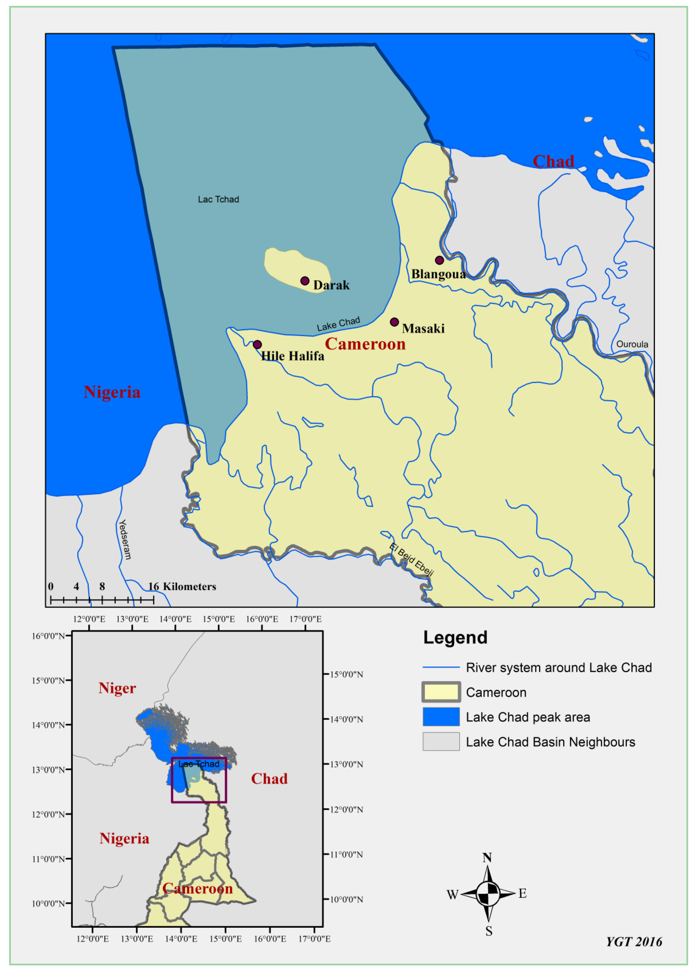
Figure 2.
Changes in the water surface area of Lake Chad from 1963 to 2013 (Source: NASA GSFC Scientific Visualization Studio. Used with permission) [27].
Figure 2.
Changes in the water surface area of Lake Chad from 1963 to 2013 (Source: NASA GSFC Scientific Visualization Studio. Used with permission) [27].

Figure 3.
The nationality of new fishers in fishing operations in Darak 1974–2007 (Source: Fieldwork).
Figure 3.
The nationality of new fishers in fishing operations in Darak 1974–2007 (Source: Fieldwork).

Figure 4.
The importance of fishing in local economies and livelihoods of the Lake Chad region. Selling of fish (a) and smoking of fish for preservation (b) in Darak.
Figure 4.
The importance of fishing in local economies and livelihoods of the Lake Chad region. Selling of fish (a) and smoking of fish for preservation (b) in Darak.

Figure 5.
Evolution of transhumance routes in the Cameroonian part of Lake Chad.

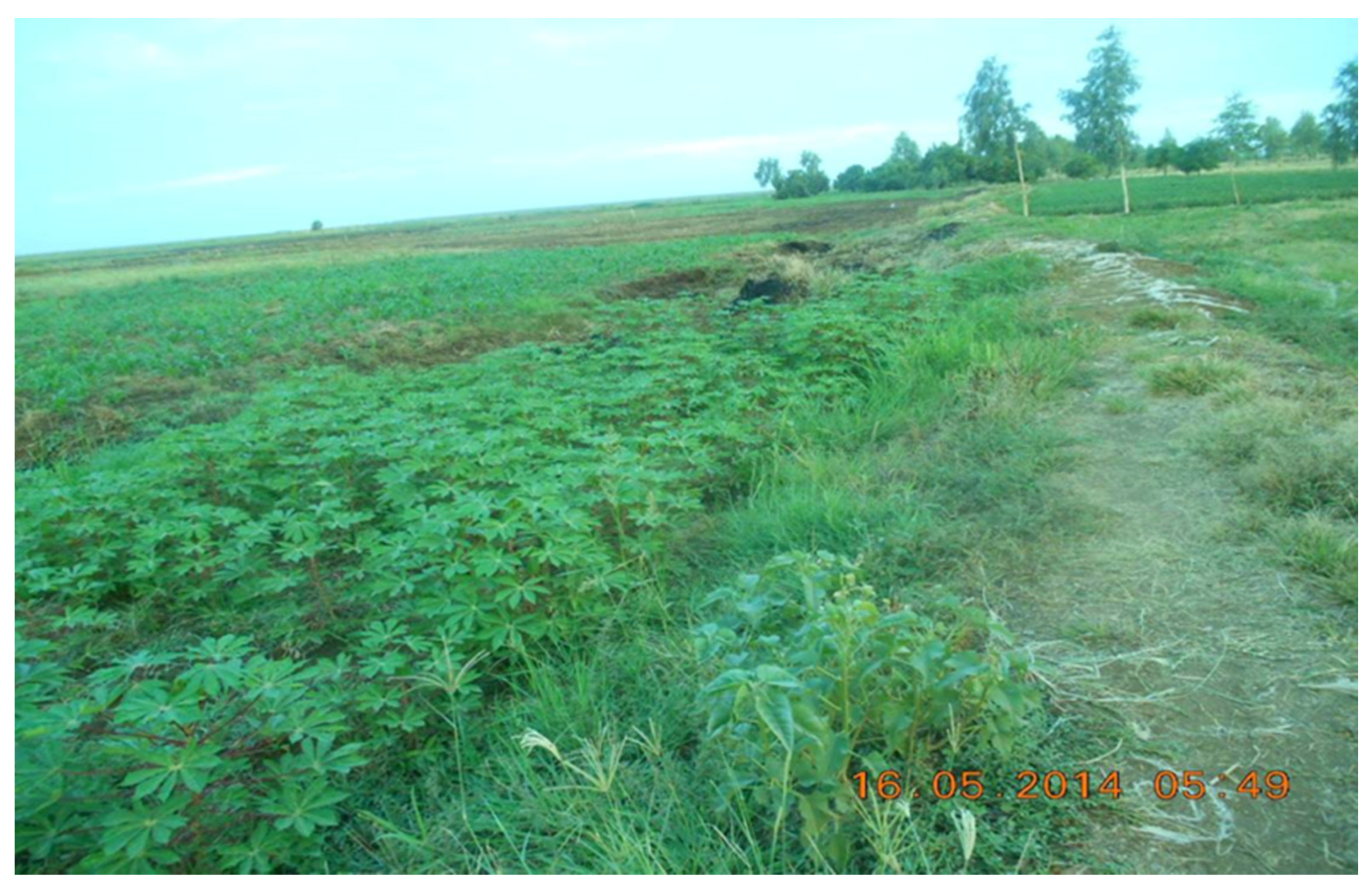
Figure 6.
A dry up area from the reducing lake supporting several small-holder farming fields in Darak.
Figure 6.
A dry up area from the reducing lake supporting several small-holder farming fields in Darak.

Figure 7.
Driving Force-Pressure-State-Impact-Response (DPSIR) applied to the Lake Chad communities in Northern Cameroon. * Indicate individual responses while ** indicate institutional responses. Given the relative newness of the phenomenon regarding increased population of seasonal migrants, the impacts are still in the process of unfolding.


Table 1.
The location, main activities and number of persons interviewed.
| Sub-Division | Villages | Year of Creation | Population | Household Heads Surveyed |
|---|---|---|---|---|
| Hilé-Alifa | Naga | 1979 | 153 | 15 |
| Ndagalgui | 1979 | 575 | 25 | |
| Bargaram II | 1980 | 918 | 20 | |
| Darak | Bouaram | 1982 | 304 | 25 |
| Darak II | 1975 | 601 | 30 | |
| HiléWanzam | 1981 | 390 | 25 | |
| GoréTchandji | 1980 | 980 | 25 | |
| Katikimé | 1971 | 367 | 25 | |
| Blangoua | Boularam | 1980 | 857 | 30 |
| Total | 220 | |||
Table 2.
Major causes of land conflicts in the Darak, Blangoua and Hilé Alifa Subdivisions.
| Causes of Conflicts | Number of Conflicts |
|---|---|
| Disagreement on the boundaries of the parcels | 64 |
| Selling of one parcel of land to several persons | 34 |
| Conflicts arising from occupation of transhumance corridors | 48 |
Table 3.
Modes of accessing land resources in the study area.
| Subdivision | Villages | Household Heads Surveyed | Clearing of New Areas | As a Gift | Buying | Renting |
|---|---|---|---|---|---|---|
| Fotokol | Naga | 15 | 3 | 0 | 2 | 10 |
| Hilé-Alifa | Ndagalgui | 25 | 6 | 0 | 3 | 16 |
| Bargaram II | 20 | 6 | 4 | 2 | 8 | |
| Darak | Bouaram | 25 | 3 | 3 | 4 | 15 |
| Darak II | 30 | 0 | 3 | 6 | 21 | |
| HiléWanzam | 25 | 2 | 4 | 6 | 13 | |
| GoréTchandji | 25 | 4 | 0 | 5 | 16 | |
| Katikimé | 25 | 4 | 8 | 0 | 13 | |
| Blangoua | Boularam | 30 | 6 | 4 | 3 | 17 |
| Total | 220 | 34 | 26 | 31 | 129 | |
© 2017 by the authors. Licensee MDPI, Basel, Switzerland. This article is an open access article distributed under the terms and conditions of the Creative Commons Attribution (CC BY) license (http://creativecommons.org/licenses/by/4.0/).
Share and Cite
MDPI and ACS Style
Zieba, F.W.; Yengoh, G.T.; Tom, A. Seasonal Migration and Settlement around Lake Chad: Strategies for Control of Resources in an Increasingly Drying Lake. Resources 2017, 6, 41. https://doi.org/10.3390/resources6030041
AMA Style
Zieba FW, Yengoh GT, Tom A. Seasonal Migration and Settlement around Lake Chad: Strategies for Control of Resources in an Increasingly Drying Lake. Resources. 2017; 6(3):41. https://doi.org/10.3390/resources6030041
Chicago/Turabian StyleZieba, Felix Watang, Genesis Tambang Yengoh, and Abdouraman Tom. 2017. "Seasonal Migration and Settlement around Lake Chad: Strategies for Control of Resources in an Increasingly Drying Lake" Resources 6, no. 3: 41. https://doi.org/10.3390/resources6030041
Note that from the first issue of 2016, this journal uses article numbers instead of page numbers. See further details here.