
Web3DGIS-Based System for Reservoir Landslide Monitoring and Early Warning


Abstract
:1. Introduction
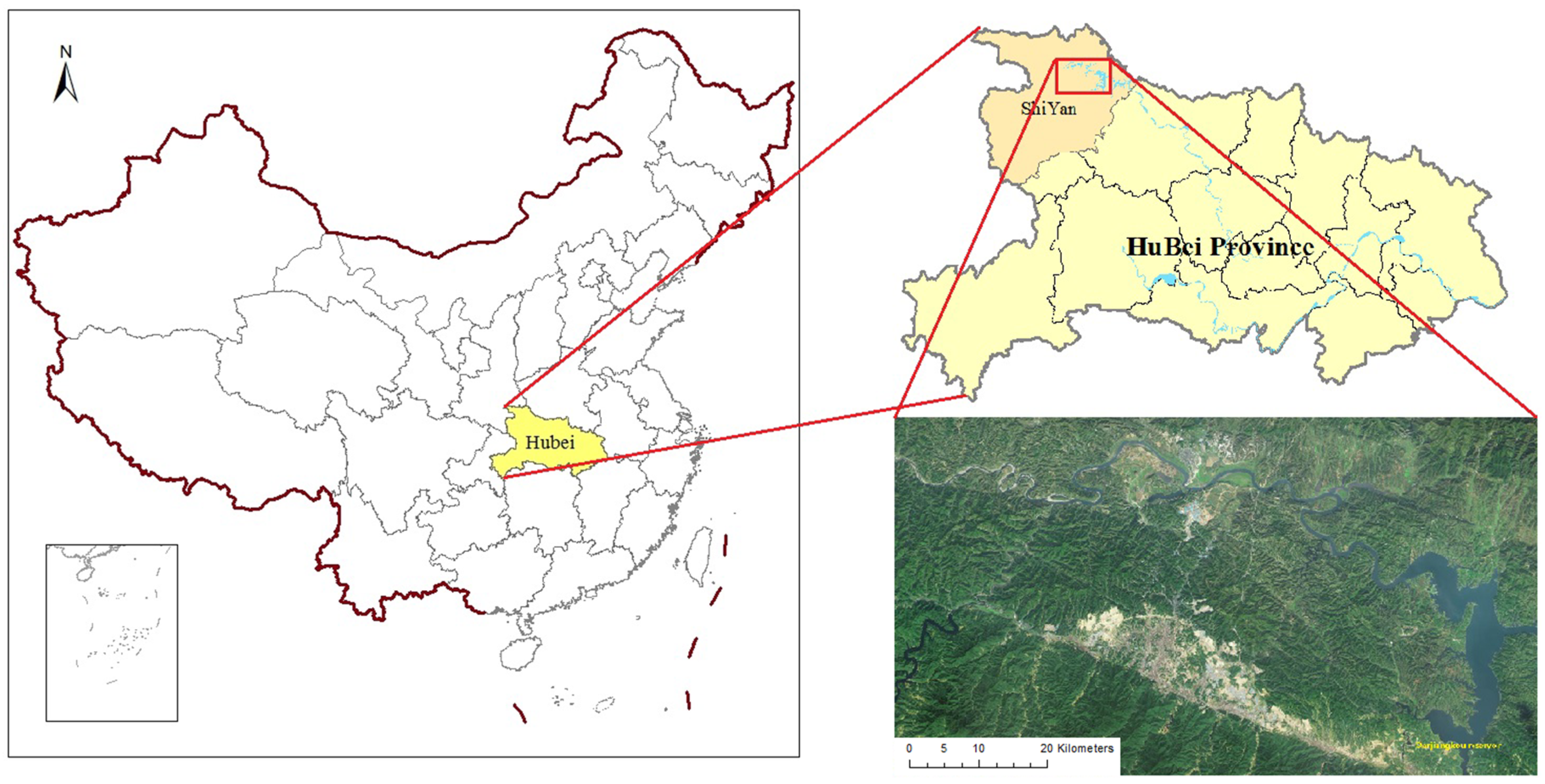
2. Target Area
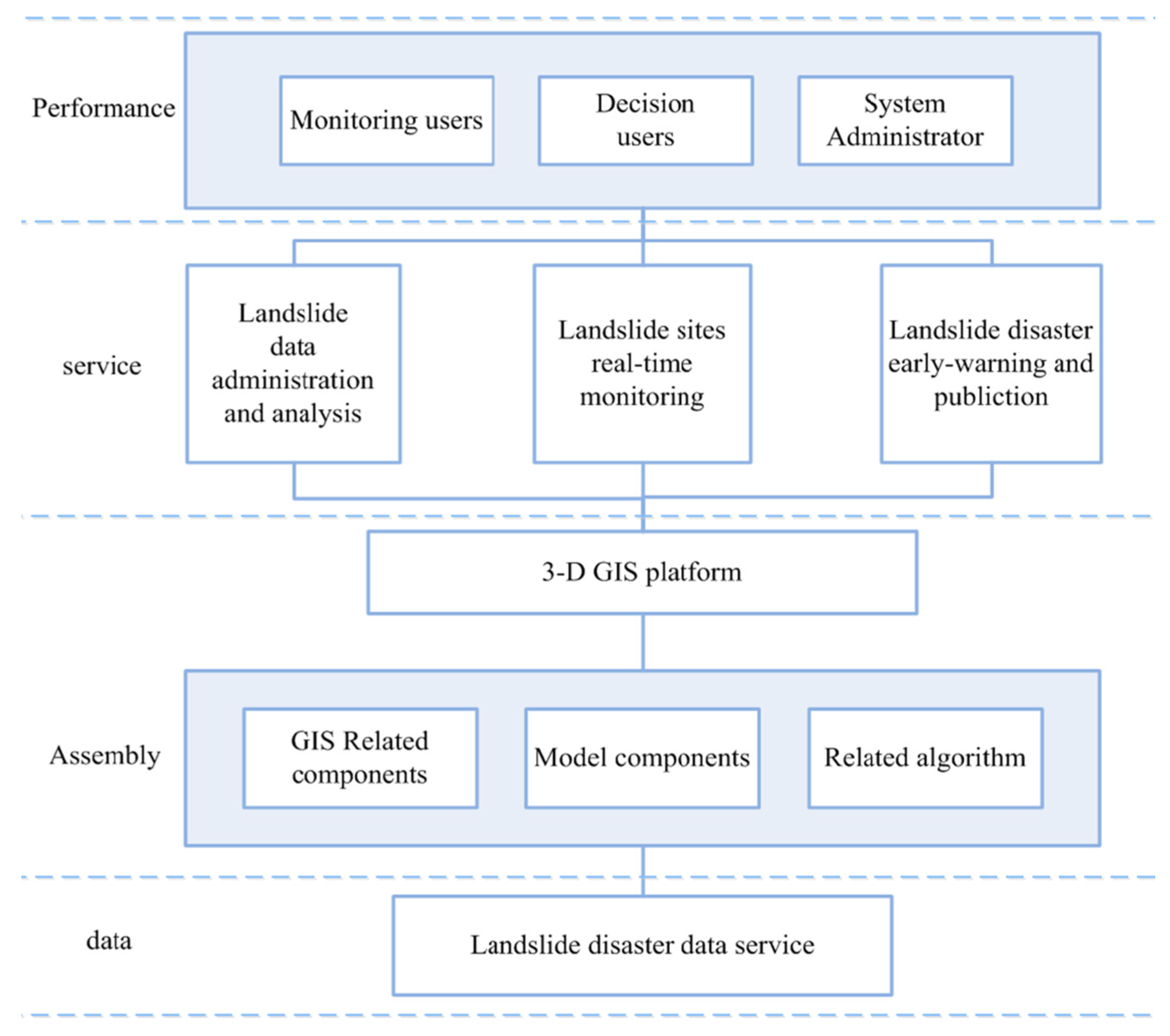
3. System Structure and Design

- (1)
- Collection and management of multiple datasets pertaining to landslides, including fundamental geographical data, real-time and historical monitoring data, acquirement, transfer, preprocessing and management of emergency service data.
- (2)
- Query research and spatial statistical analysis, including comprehensive querying of each monitoring site (e.g., feature, section, and sphere) and statistical analysis of feature data.
- (3)
- Landslide early warning and related information publishing. Based on the features of the potential landslide location and its real-time monitoring data, a model for landslide forecasting and emergency warning that is able to publish potential disaster evaluation information to the public and relevant departments is selected.
- (4)
- Expression and analysis of three-dimensional information, including a three-dimensional depiction of the target area and key monitoring locations. Focused on data relating to flow fields and groundwater level, a combination of functions and needs was developed to address landslide prediction and the evaluation of relevant three-dimensional spatial analysis.
- (5)
- Support functions, including user management, operational right management, data management and maintenance, and other regular functions.
4. Key Technologies
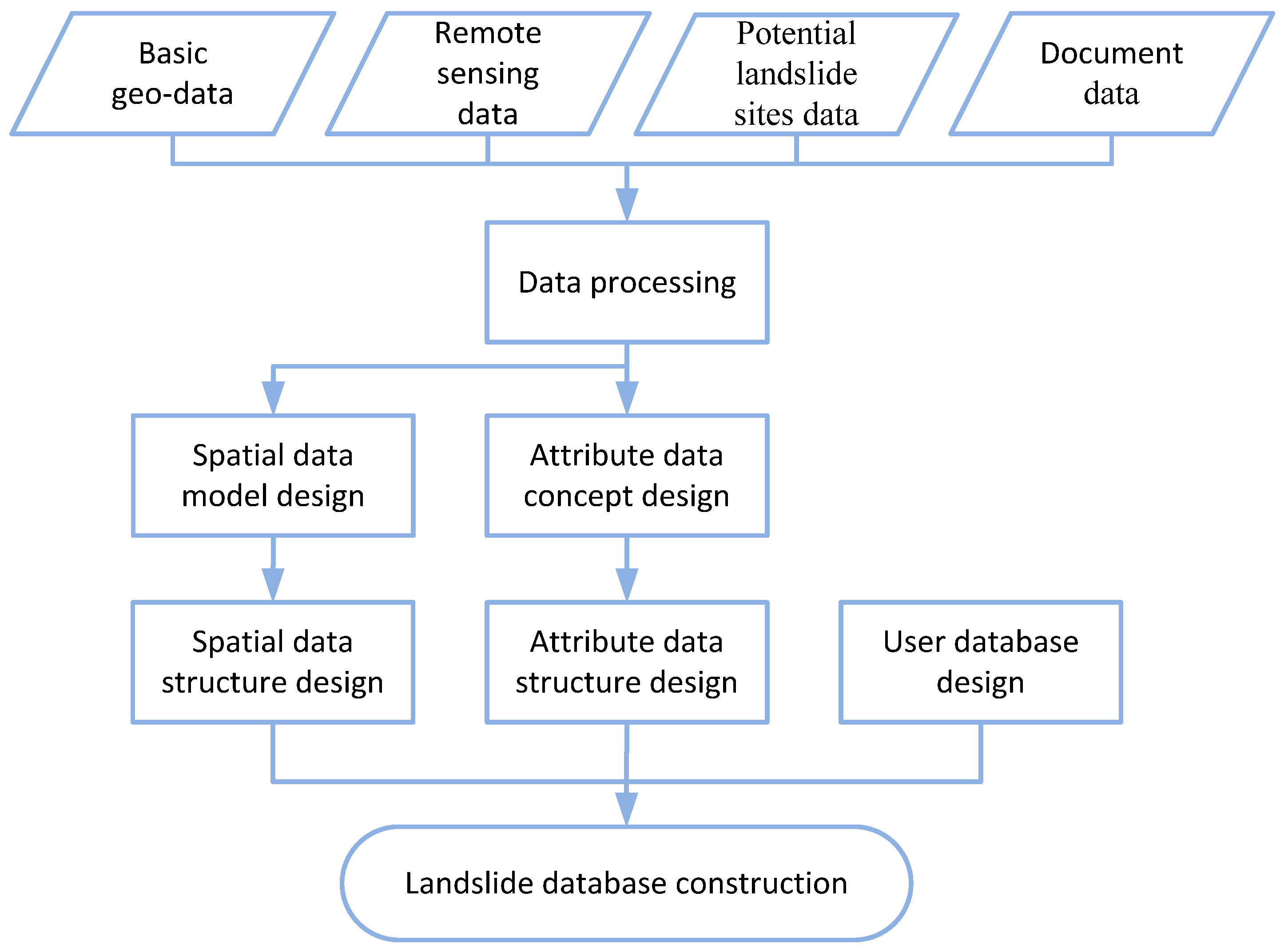
4.1. Multi-Data Organization and Management
4.1.1. Special Data Pool for Landslide Monitoring

| Categories | Data Contents | |
|---|---|---|
| Static data | Basic geographical data | Basic arrow data on geological information, including big scale administration division, lake and water systems, residential area, and lattice spatial data for the digital elevation model |
| Remote sensing image data | Aerial image and satellite-borne remote sensing image data | |
| Survey data about potential landslide sites | Plane graph, profile, location map of landslides, rock and soil mass characteristics data | |
| Documentary information and other data | Relevant statistical materials recorded about historical disasters, photos, and technical reports. | |
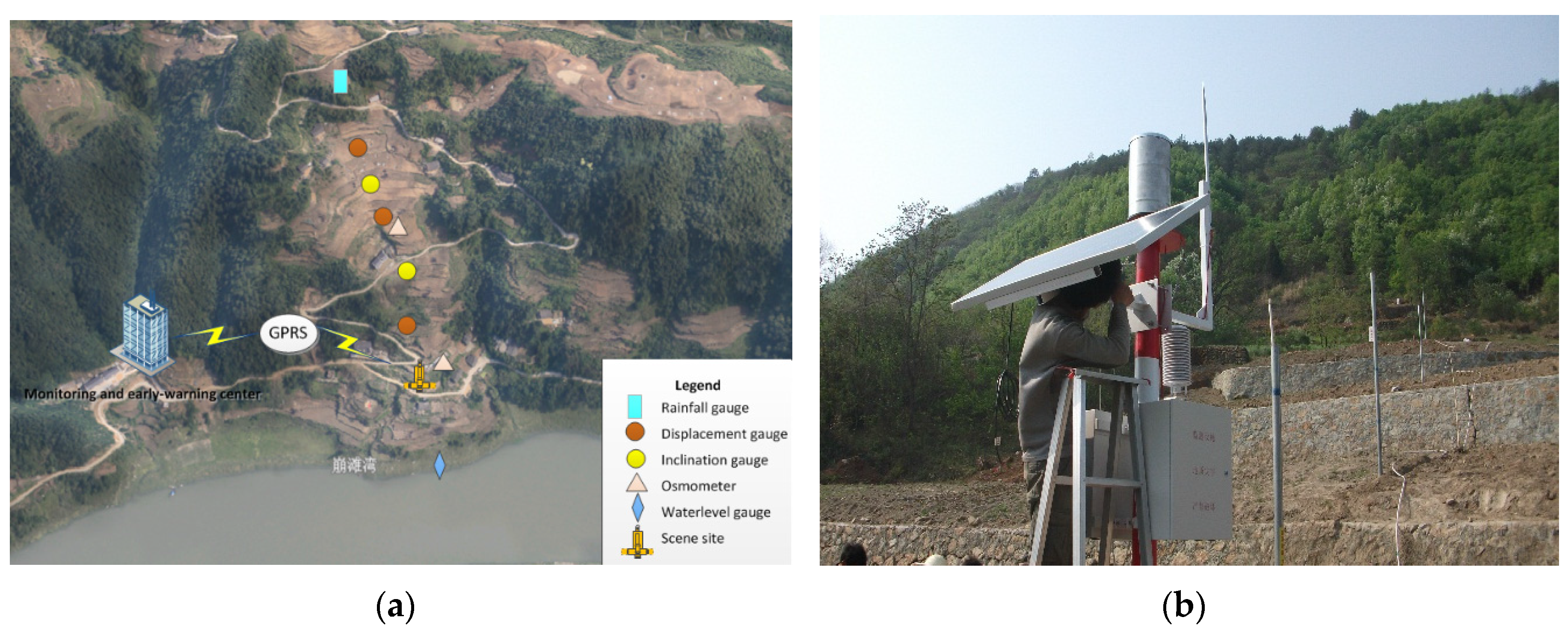
| Dynamic data | Sensor monitoring data from potential landslide sites | Ground surface displacement, depth displacement, groundwater level, inclination and rainfall |


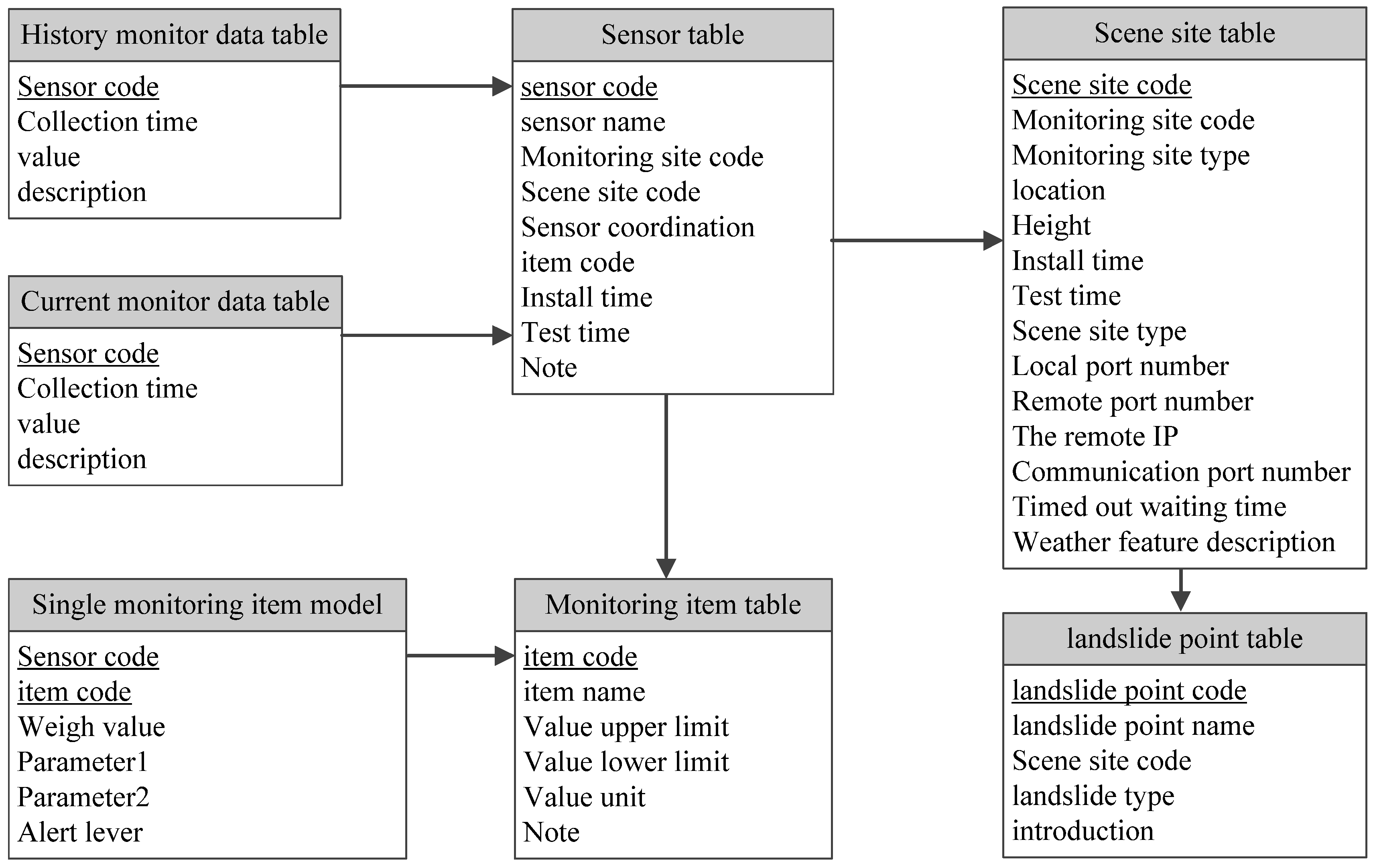
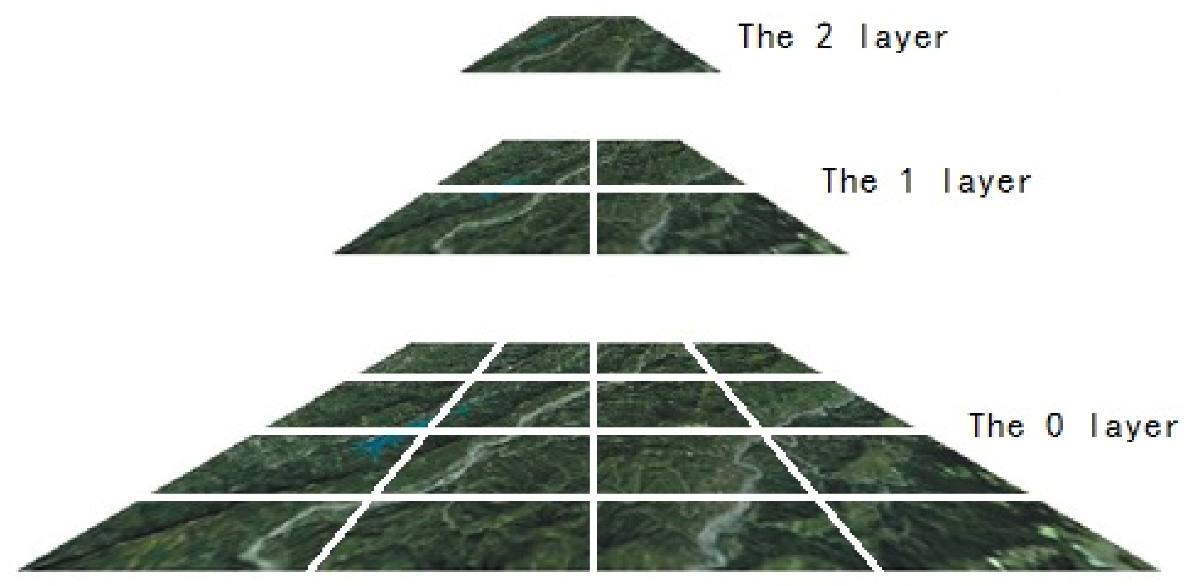
4.1.2. Three-Dimensional Scene Data Organization
4.2. Landslide Forecasting Model
- (1)
- Non-linear dynamics model. By nature, landslides are a non-linear dynamic systems controlled by soil and rock conditions (e.g., topography, groundwater, rainfalls, and human engineering). The non-linear dynamics model has long been used [39,40], and has been developed to reach a high level of accuracy in the short-term prediction of landslides. This study applied the non-linear dynamics model proposed by Qin et al. [19], which makes predictions based on three major factors: stress, landslide displacement, and groundwater.
- (2)
- Grey forecasting model. This model, proposed by Deng, is a method for forecasting systems with uncertain factors [38]. By collecting slices of incomplete information, this model was built to consider a long-term general description of a system’s development. Luan et al. [41] used this method to monitor and forecast ground surface deformation, and since then it has been commonly used in landslide forecasting [42,43,44]. In this study, the grey model was combined with a time sequence analysis model, such that after amendment of the residual model in time sequence, it was able to forecast trends of uniform motion-accelerating motion, accelerating motion-uniform motion, slow change-uniform motion, and slow change-accelerating motion. Through extraction of the items, which shock periodically, the model can greatly offset influences from external factors.
- (3)
- Multi-factor grey forecasting model. This model, from the perspective of both internal and external factors that can affect landslide deformation, regards the whole landslide as the production of multiple affecting factors. The description of internal affecting factors are modeled after a tendency grey model that varies with different periods, while external affecting factors can be divided into several independent but related linear factors. By combining the model with internal and external factors, a multiple and combined model is constructed and can be used for grey forecasting [45]. The multi grey model considers both external and internal factors relating to deformation, and when these change, the deformation value can be estimated as a fixed quantity. The model is suitable for forecasting landslide deformation affected by external factors (e.g., rainfall and groundwater level).
5. System Completion
5.1. Sensors Deployment

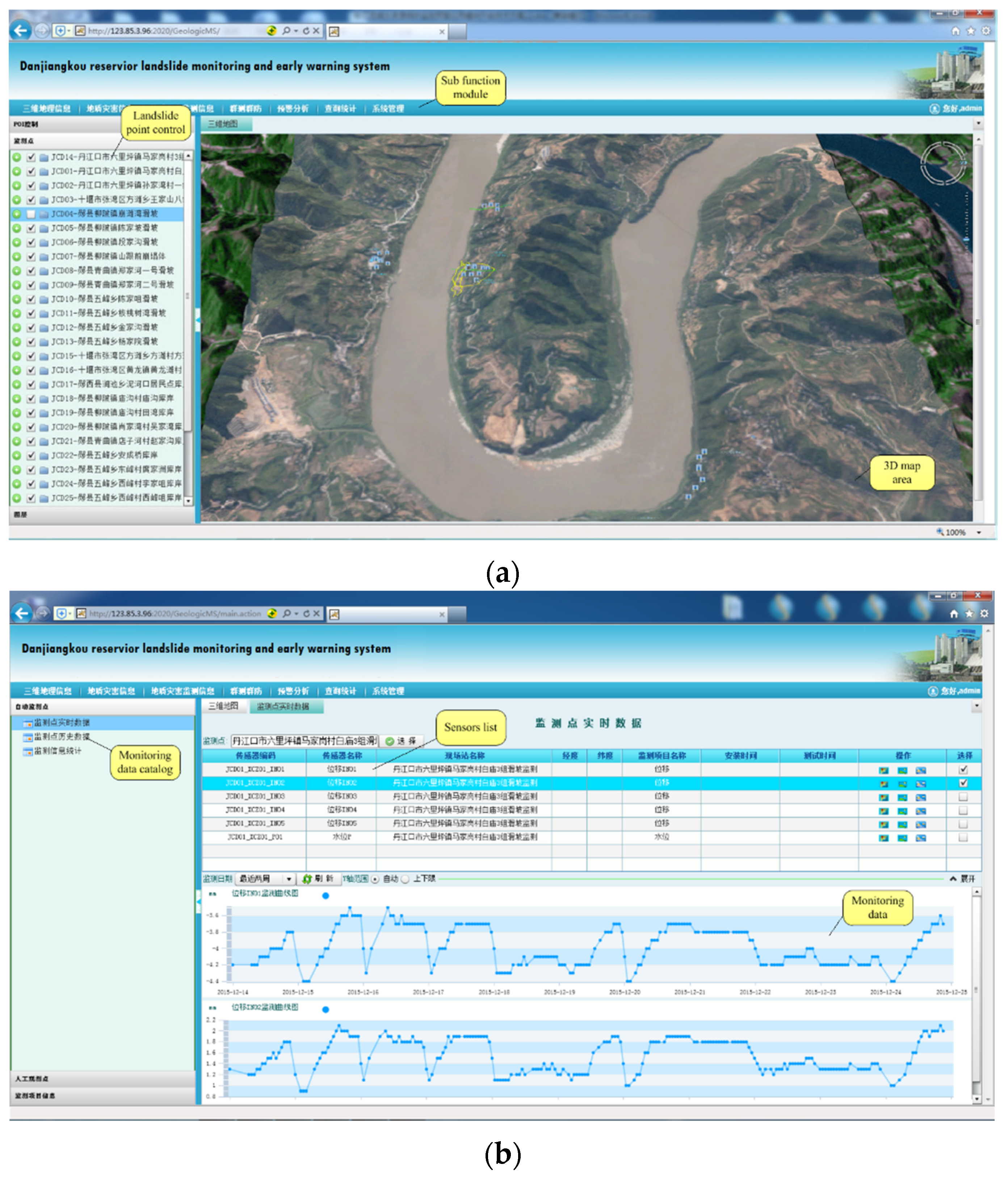
5.2. Software System Completion

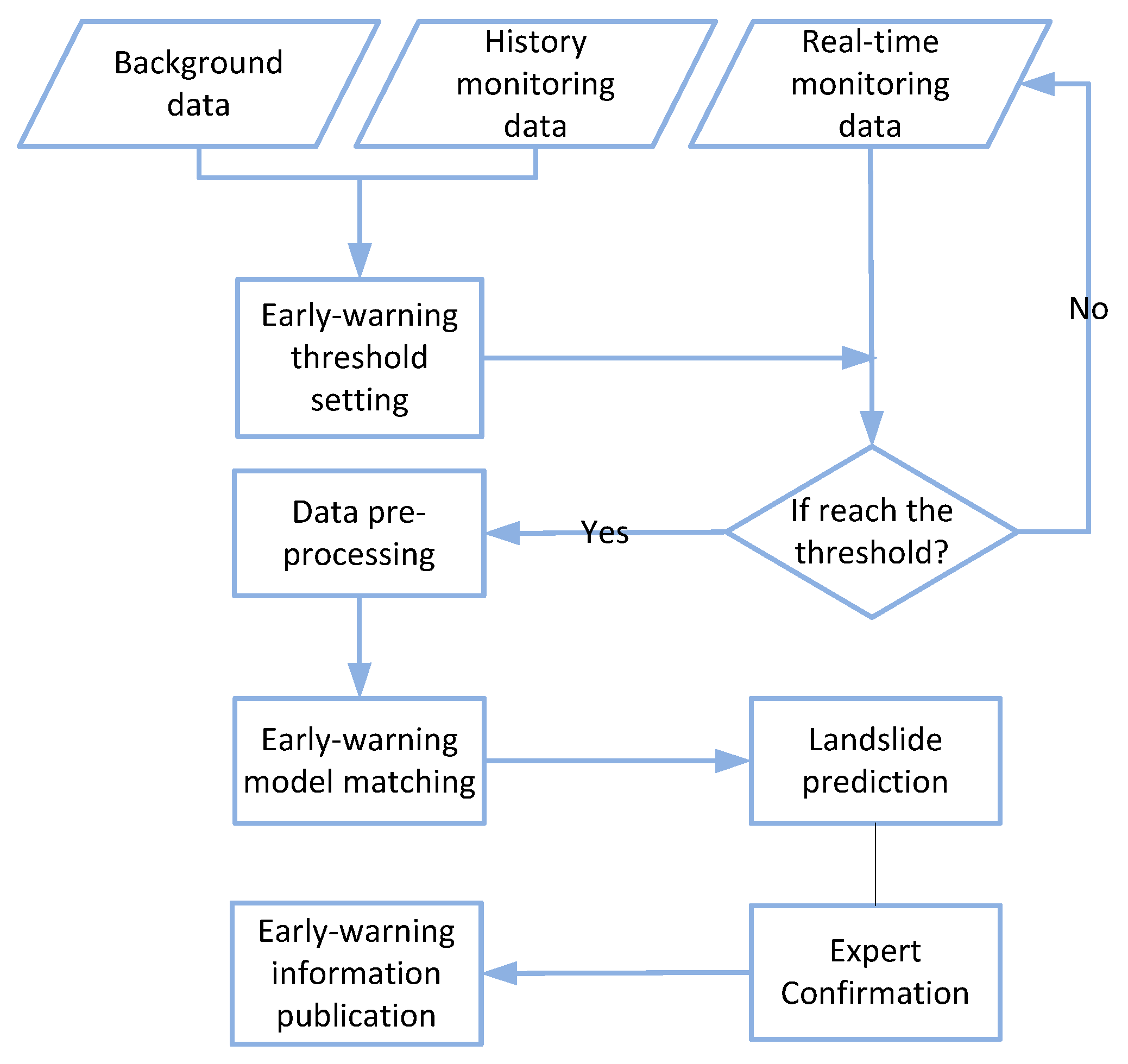
5.3. Early Warning Completion

6. Conclusions
Acknowledgments
Author Contributions
Conflicts of Interest
References
- Mantovani, F.; Soeters, R.; van Westen, C.J. Remote sensing techniques for landslide studies and hazard zonation in Europe. Geomorphology 1996, 15, 213–225. [Google Scholar]
- Gili, J.A.; Corominas, J.; Rius, J. Using Global Positioning System techniques in landslide monitoring. Eng. Geol. 2000, 55, 167–192. [Google Scholar]
- Squarzoni, C.; Delacourt, C.; Allemand, P. Differential single-frequency GPS monitoring of the La Valette landslide (French Alps). Eng. Geol. 2005, 79, 215–229. [Google Scholar] [CrossRef]
- Xiao, R.; He, X. Real-time landslide monitoring of Pubugou hydropower resettlement zone using continuous GPS. Nat. Hazards 2013, 69, 1647–1660. [Google Scholar]
- Palmerini, G. Capabilities of the GNSS precise point positioning technique for landslide monitoring. Disaster Adv. 2012, 5, 509–513. [Google Scholar]
- Wang, G.Q. Millimeter-accuracy GPS landslide monitoring using Precise Point Positioning with Single Receiver Phase Ambiguity (PPP-SRPA) resolution: A case study in Puerto Rico. J. Geod. Sci. 2013, 3, 22–31. [Google Scholar]
- Yigit, C. Experimental assessment of post-processed kinematic Precise Point Positioning method for structural health monitoring. Geomat. Nat. Hazards Risk 2014, 7. [Google Scholar] [CrossRef]
- Dowding, C.H.; Huang, F.C. Early detection of rock movement with time domain reflectometry. J. Geotech. Eng. 1994, 120, 1413–1427. [Google Scholar] [CrossRef]
- Kane, W.F.; Perez, H.; Anderson, N.O. Development of Time Domain Reflectometry System to Monitor Landslide Activity; Final Report, FHWA/CA/TL-96/09; Federal Highway Administration: Washington, DC, USA, 1996. [Google Scholar]
- Fruneau, B.; Achache, J.; Delacourt, C. Observation and modelling of the Saint-Etienne-de-Tinée landslide using SAR interferometry. Tectonophysics 1996, 265, 181–190. [Google Scholar]
- Carnec, C.; Delacourt, C. Three years of mining subsidence monitored by SAR interferometry, near Gardanne, France. J. Appl. Geophys. 2000, 43, 43–54. [Google Scholar]
- Ohnishi, Y.; Nishiyama, S.; Yano, T.; Matsuyama, H.; Amano, K. A study of the application of digital photogrammetry to slope monitoring systems. Int. J. Rock Mech. Min. Sci. 2006, 43, 756–766. [Google Scholar] [CrossRef]
- Atzeni, C.; Barla, M.; Pieraccini, M.; Antolini, F. Early Warning Monitoring of natural and engineering slopes with Ground-based Synthetic Aperture Radar. Rock Mech. Rock Eng. 2015, 48, 235–236. [Google Scholar]
- Angeli, M.G.; Pasuto, A.; Silvano, S. A critical review of landslide monitoring experiences. Eng. Geol. 2000, 55, 133–147. [Google Scholar] [CrossRef]
- Ramesh, M.V. Real-time wireless sensor network for landslide detection. In Proceedings of the Third International Conference on Sensor Technologies and Applications, SENSORCOMM’09, Athens, Greece, 18–23 June 2009; pp. 405–409.
- Xia, Y. Grey System Prediction Model of Landslide and Its Application. Chin. Sci. Abstr. Ser. B 1995, 14, 74. [Google Scholar]
- Chen, H.W.; Chang, N.B. Prediction analysis of solid waste generation based on grey fuzzy dynamic modeling. Resour. Conserv. Recycl. 2000, 29, 1–18. [Google Scholar]
- Chung, C.J.F.; Fabbri, A.G. Probabilistic prediction models for landslide hazard mapping. Photogramm. Eng. Remote Sens. 1999, 65, 1389–1399. [Google Scholar]
- Qin, S.; Jiao, J.J.; Wang, S. A nonlinear dynamical model of landslide evolution. Geomorphology 2002, 43, 77–85. [Google Scholar]
- Carrara, A.; Guzzetti, F.; Cardinali, M.; Reichenbach, P. Use of GIS technology in the prediction and monitoring of landslide hazard. Nat. Hazards 1999, 20, 117–135. [Google Scholar]
- Zan, L.; Latini, G.; Piscina, E.; Polloni, G.; Baldelli, P. Landslides early warning monitoring system. In Proceedings of the 2002 IEEE International Geoscience and Remote Sensing Symposium, IGARSS’02, Honolulu, Hawaii, USA, 25–30 July 2002; Volume 1, pp. 188–190.
- Yin, Y.; Wang, H.; Gao, Y.; Li, X. Real-time monitoring and early warning of landslides at relocated Wushan Town, the Three Gorges Reservoir, China. Landslides 2010, 7, 339–349. [Google Scholar]
- Gao, H.X.; Yin, K.L. Study on spatial prediction and time forecast of landslide. Nat. Hazards 2014, 70, 1735–1748. [Google Scholar]
- Barla, M.; Antolini, F. An integrated methodology for landslides early warning systems. Landslides 2015, 1–14. [Google Scholar] [CrossRef]
- Costanzo, S.; Di Massa, G.; Costanzo, A.; Morrone, L.; Raffo, A.; Spadafora, F.; Borgia, A.; Formetta, G.; Capparelli, G.; Versace, P. Low-cost radars integrated into a landslide early warning systems. Adv. Intell. Syst. Comput. 2015, 354, 11–19. [Google Scholar]
- Huang, R.; Huang, J.; Ju, N.; He, C.; Li, W. WebGIS-based information management system for landslides triggered by Wenchuan earthquake. Nat. Hazards 2013, 65, 1507–1517. [Google Scholar]
- Mao, S.J.; Liu, Q.X.; Li, M. Design and development of safety production management information system based on a digital coalmine. Procedia Earth Planet. Sci. 2009, 1, 1121–1127. [Google Scholar]
- Intrieri, E.; Gigli, G.; Mugnai, F.; Fanti, R.; Casagli, N. Design and implementation of a landslide early warning system. Eng. Geol. 2012, 147, 124–136. [Google Scholar]
- Zerger, A.; Smith, D.I. Impediments to using GIS for real-time disaster decision support. Comput. Environ. Urban Syst. 2003, 27, 123–141. [Google Scholar]
- Yu, F.C.; Chen, C.Y.; Lin, S.C.; Lin, Y.C.; Wu, S.Y.; Cheung, K.W. A web-based decision support system for slopeland hazard warning. Environ. Monit. Assess. 2007, 127, 419–428. [Google Scholar] [PubMed]
- Chang, K.T.; Wan, S.; Lei, T.C. Development of a spatial decision support system for monitoring earthquake-induced landslides based on aerial photographs and the finite element method. Int. J. Appl. Earth Obs. Geoinform. 2010, 12, 448–456. [Google Scholar] [CrossRef]
- Giardino, M.; Perotti, L.; Lanfranco, M.; Perrone, G. GIS and geomatics for disaster management and emergency relief: A proactive response to natural hazards. Appl. Geomat. 2012, 4, 33–46. [Google Scholar]
- Finkel, R.A.; Bentley, J.L. Quad trees a data structure for retrieval on composite keys. Acta Inform. 1974, 4, 1–9. [Google Scholar]
- Heeger, D.J.; Bergen, J.R. Pyramid-based texture analysis/synthesis. In Proceedings of the 22nd Annual Conference on Computer Graphics and Interactive Techniques, Los Angeles, CA, USA, 9–13 August 1995; pp. 229–238.
- Saito, M. Forecasting time of slope failure by tertiary creep. In Proceedings of the 7th International Conference of Soil Mechanics and Foundation Engineering, Mexico City, Mexico, 5–7 May 1969; pp. 677–683.
- Zhou, C.B.; Zhang, H. A creep-spline combined model and its application to the time prediction of landslides. J. Nat. Disasters 1996, 5, 60–67. [Google Scholar]
- Li, T.B.; Chen, M.D. Time prediction of landslide using verhulst inverse-function model. J. Geol. Hazards Environ. Preserv. 1996, 3, 13–17. [Google Scholar]
- Deng, J.L. Control problems of grey systems. Syst. Control Lett. 1982, 1, 288–294. [Google Scholar]
- Haigh, M.J. Dynamic Systems Approaches in Landslide Hazard Research; Zeitschrift für Geomorphologie; Supplementbände; Schweizerbart science publishers: Stuttgart, Germany, 1988; Volume 67, pp. 79–81. [Google Scholar]
- Phillips, J.D. Instability and chaos in hillslope evolution. Am. J. Sci. 1993, 293, 25. [Google Scholar]
- Luan, Y.Z.; Jiang, Y.; Jia, M.H. Forecasting the ground subsidence in mine area by grey system. Site Investig. Sci. Technol. 1990, 5, 45–48. [Google Scholar]
- Li, X.H.; Jin, X.G.; Kang, H.M.; Lu, Y.; Yang, X.H. Application of GM (1,1) Majorized Model to Simulation-forecast of Landslide. J. Mt. Sci. 2001, 19, 265–269. [Google Scholar]
- Lu, P.; Rosenbaum, M.S. Artificial neural networks and grey systems for the prediction of slope stability. Nat. Hazards 2003, 30, 383–398. [Google Scholar]
- Li, X.; Kong, J.; Wang, Z. Landslide displacement prediction based on combining method with optimal weight. Nat. Hazards 2012, 61, 635–646. [Google Scholar] [CrossRef]
- Wang, X.; Niu, R. Landslide intelligent prediction using object-oriented method. Soil Dyn. Earthq. Eng. 2010, 30, 1478–1486. [Google Scholar]
© 2016 by the authors; licensee MDPI, Basel, Switzerland. This article is an open access article distributed under the terms and conditions of the Creative Commons by Attribution (CC-BY) license (http://creativecommons.org/licenses/by/4.0/).
Share and Cite
Huang, H.; Ni, J.; Zhang, Y.; Qian, T.; Shen, D.; Wang, J. Web3DGIS-Based System for Reservoir Landslide Monitoring and Early Warning. Appl. Sci. 2016, 6, 44. https://doi.org/10.3390/app6020044
Huang H, Ni J, Zhang Y, Qian T, Shen D, Wang J. Web3DGIS-Based System for Reservoir Landslide Monitoring and Early Warning. Applied Sciences. 2016; 6(2):44. https://doi.org/10.3390/app6020044
Chicago/Turabian StyleHuang, Huang, Jianhua Ni, Yu Zhang, Tianlu Qian, Dingtao Shen, and Jiechen Wang. 2016. "Web3DGIS-Based System for Reservoir Landslide Monitoring and Early Warning" Applied Sciences 6, no. 2: 44. https://doi.org/10.3390/app6020044