Tailoring Signs to Engage Two Distinct Types of Geotourists to Geological Sites

Department of Educational Leadership and Management, Drexel University, 3141 Chestnut Street, Philadelphia, PA 19104, USA
Geosciences 2018, 8(9), 329; https://doi.org/10.3390/geosciences8090329
Submission received: 30 July 2018
/
Revised: 16 August 2018
/
Accepted: 29 August 2018
/
Published: 3 September 2018
(This article belongs to the Special Issue Geotourism)
Abstract
:Interpretive signs are the silent ambassadors of geosites and serve a diverse audience. The primary aim of this study is to develop signs for geosites targeted at two unique groups of geotourists. A conceptual multidisciplinary geotourist typology is formulated to identify two main classes of geotourists comprising the audience. Latent and archetypal geotourists inhabit various roles at geotourism sites depending on their expectations for the event, affecting the visitor experience via fluid contextual factors. Principally, latent geotourists arrive seeking novel touristic experiences while archetypal geotourists seek knowledge-building opportunities. Because signs represent one fragment of the multi-dimensional visitor experience, an approach that offers a palette of options is advocated. After the unified typology to identify the audience is presented, a multi-layered technique that offers both interpretation and a link to augmented information on signs is suggested. Some best practices in sign design are described and preliminary plans for testing are shared. The author’s overriding goal is to refine the mechanics and format of signs to garner maximum attracting and holding power, ensuring that the message is read and the target outcome is achieved. By providing tools to visitors to geological sites that enable them to create narratives that are compatible with their expectations, we facilitate a multi-dimensional constructive experience that engages everyone.
1. Introduction
Early accounts of tourists who visited the Alps reveal not only a sense of wonder, but also a desire to know the stories behind the landscapes they encountered. There is an eagerness to make sense of the landforms and to decode the geomorphological processes matched only by an apparent joy in witnessing their grandeur. For these daring travelers, the legends and myths of the past are no longer satisfactory in explaining the sublime features that lie before them in a vast wild frontier [1] (pp. 183–184, 201).
“The view from the summit displayed nearly the whole course of the Gail (River) and the picturesque and numerous forms of the Lienz Dolomites(...)with a small glacier running down from them almost to the edge of its magnificent precipice(.) This valley, remote as it seems from the volcanic region of Italy, has yet suffered from an earthquake. On 25 January 1348, (it destroyed the valley) and brought down a mighty mass of Mount Dobratsch(...)burying several villages and hamlets, and stopping the course of the Gail. From this a great lake was formed(...)whose borders are still visible” [1].
As we can see from this 1861 journal entry, these were some of the original geotourists, embracing the aesthetic value of the landscape and likewise satisfying curiosity and attempting to acquire knowledge through observations in the field. Only those with means and education could participate in such leisure activities, because they were challenging, dangerous, and expensive, but also highly specialized. Indeed, this intrepid party chose the valley specifically because they were the first tourists to ever visit [1].
Their route is at the heart of the Alps, one of the most well-known tourist regions in Europe today. Long before plate tectonic theory was advanced, these visitors had their own ideas about the earthquake in the Gail Valley. We now know that it lies on a continental tectonic divide known as the Periadriatic Lineament [2] where a number of geology-themed trails and an official ‘geopark’ are located. One must not wonder about the valley’s geomorphology because most sites are outfitted with information for visitors.
In this special issue, geotourism has been amply defined and its long history described [3]. The application of the term ‘geotourism’ has become somewhat disputed since a meeting in 2011 at the Arouca Geopark in Portugal, where a new definition was agreed upon, without input from widely-cited scientists in the field who were regrettably not invited to the proceedings [4,5]. Admittedly, there was a need for the clarification of the term as there was no universally accepted definition of geotourism, as Dowling and Newsome [6] remarked, but a failure to include top experts in the decision bifurcated the field. Hose [5] (p. 5) relates the outcome, “The Arouca Declaration in 2011. accepted the National Geographic approach [and] indicated ‘that there is a need to clarify the concept of geotourism. We therefore believe that geotourism should be defined as tourism which sustains and enhances the identity of a territory, taking into consideration its geology, environment, culture, aesthetics, heritage, and the well-being of its residents. Geological tourism is one of the multiple components of geotourism.’ The committee, probably unwittingly, had actually embraced ‘ecotourism’.” The author agrees with Hose [4], who commented, “National Geographic, as a latecomer in 2002, would be asked to find another term for their geographical approach to tourism.” This is no longer realistic, but the minor conflicts the new definition spawned can be remedied.
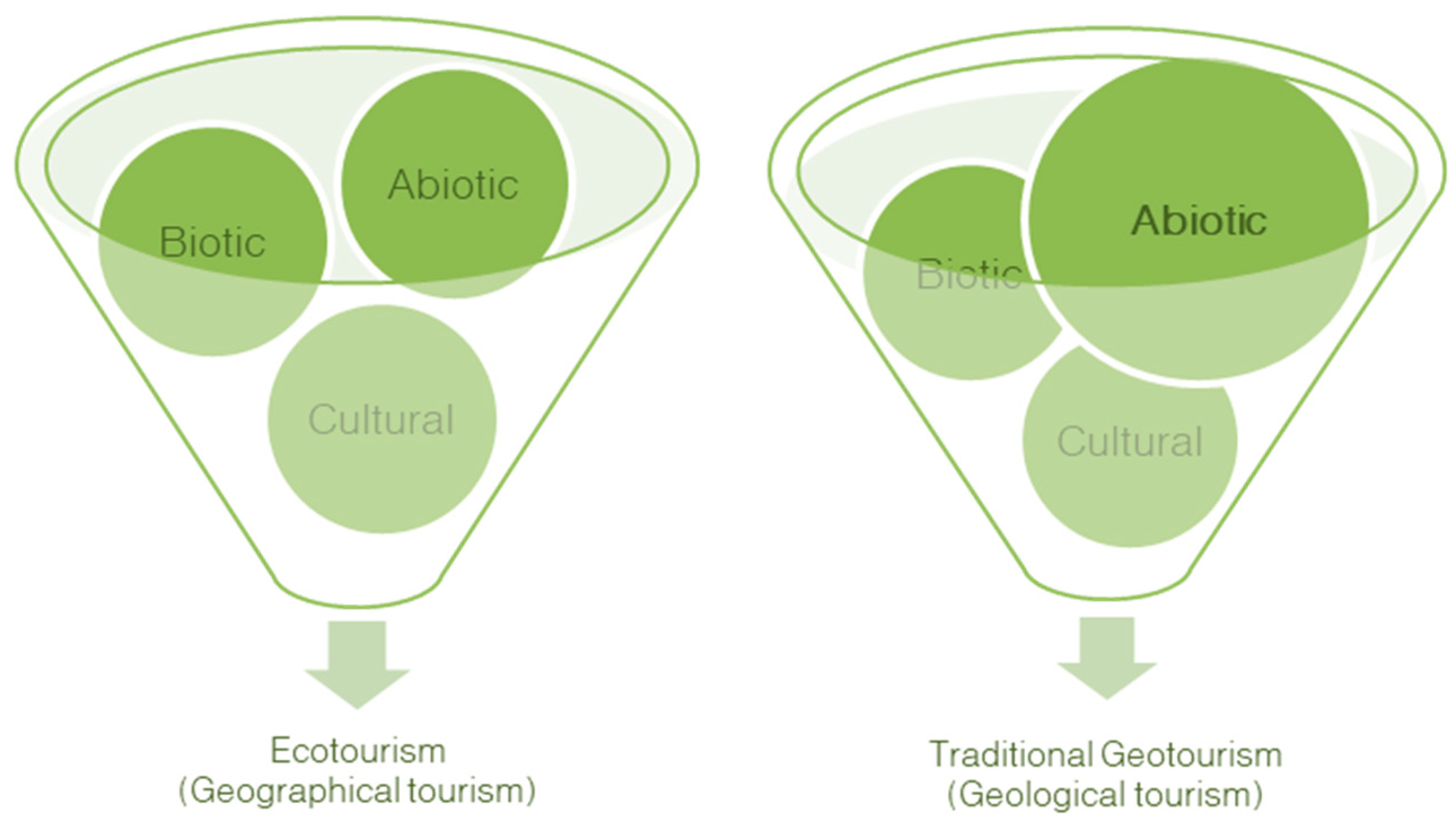
The world over, geological sites—or geosites, in geotourism parlance—face threats and issues of sustainable tourist management and conservation while coping with an enormous surge in tourist numbers [7,8,9,10]. Geology demands protection as landscapes are endangered more than ever by mass tourism [7,11,12,13], depreciative tourist behavior [6,14,15,16,17,18], politics [19,20], and overdevelopment [21,22,23,24]. Indeed, the presumed negative effect on geological awareness was one of the concerns of the geotourism field after the Arouca Declaration (see Figure 1). As Dowling remarked:
It is my contention that in this ‘ABC’ [abiotic, biotic, cultural] approach to the environment, it is the ‘A’ element that is least understood, yet is foundational to our understanding of the environment, and tourism related to it. Thus, any attempt to put a greater emphasis on the Abiotic features of the Earth, that is, the geological elements and landform features, is welcomed. (as quoted in Tourtellot [4]).
Dowling and Newsome [6] describe the fundamental considerations necessary for the provision of geotourism; namely attractions, accommodation, tours, activities, interpretation, planning, and management. This paper’s focus is on the mechanics of on-site interpretation or informational signage and how to serve an audience potentially interested in the geosciences. Owing to the current paper’s focus, Hose’s definition of geotourism is adhered to [10] (p. 136): “Provision of interpretative facilities and services to promote the value and societal benefit of geologic and geomorphologic sites and their materials, and ensure their conservation, for the use of students, tourists, and other recreationalists.” Importantly, Hose refers to facilities both on- and off-site. Interpretative facilities or interpretation refers to objects designed to convey educational or entertaining information about a site. A few outdoor examples are in Figure 2.
Signs are just one part of what is, ideally, a multi-dimensional visitor experience [10,11,26,27]. However, sometimes one interpretive sign is the sole ambassador for an attraction, making it a silent liaison between the visitor and what they hope to obtain from their visit. Interpretive signs are found in myriad venues such as outdoor trails, geoparks, national, state, and municipal parks both in the United States and abroad, even at rest stops along the road. They can be present anywhere where a geological attraction may be found. Though official geoparks and geotrails do not exist there in the same form as they do elsewhere in the world, in the United States the National Park Service sees millions of visitors annually at geological sites such as the Grand Canyon and Yellowstone National Park [8], and informational signs are a fundamental part of their multi-layered experience.
Interpretation is not the dumbing down, but rather the recontextualization of information to suit the audience [28]. It is “a complex issue with some seeing it as an educational activity trying to change people’s attitudes and behaviour, whilst others prefer to emphasise (sic) its practical value in providing entertainment for and the management of visitors” [29]. Divorcing interpretation from its outcomes for the time and looking at it from a purely practical standpoint, the aim of this formative study is to provide visitors with the tools to construct the experience they seek [30]. “(An experience) becomes memorable if visitors are given the raw materials and/or the tools to create their own narratives” [30], narratives that are compatible with expectations. People desire a range of diverse information from which to choose, depending on their moods and contexts of their visits [30]. However, at some geotourism sites, there is scant geoscientific information of any kind: neither re-contextualized for tourists nor technical for those with deep interest in geology. Provisions for both audiences are important.
Geotourism developers can inspire a sense of attachment to a place and add value to the experiences provided when they know more about the audience [31]. Lasting memories are formed when identity-related motivations [32,33,34,35], such as social bonding or the satiation of curiosity, are built into the event. In fact, learning has become an integral and satisfying part of the tourist experience [32]; it can awaken curiosity in visitors, lead to the development of a new interest or hobby [34], or even generate a passion for the geosciences [26,31,35]. Interpretation is also celebrated for its facility to move the public to care [36,37]. Freeman Tilden, one of the fathers of interpretation, describes the delicate balance necessary [36]: “Whether we call it so or not, the interpreter is engaged in a kind of education. It is not the classroom kind. It is, if you will, a proffer of teaching; but it is not the professional sort. We appeal to the head, to the mind.”
In a world where some sightseers think nothing of intentionally destroying speleothems and other formations that they presumably see as “just rocks” [15,16], losing geological emphasis as depicted in Figure 1 is detrimental to geoconservation [12,24]. We know that the public finds biological features interesting [38] and the human aspects of cultural heritage beckon us to their colorful, playful, and delicious domain, but the inclusion of abiotic features is critical because geology needs a champion [12,24,27]. Yet, at some ostensible geotourism sites, one wades through multiple signs to find a mere kernel of generic geoscientific information. A journey to a geosite ends in frustration as one is forced to search for something that should be fundamental: access to geoscience information at a geotourism site. What is required is a scheme that is entertaining, creates excitement about geology, leaves the reader wanting more, and provides a way for them to get it, no matter what their individual interest levels.
Geosites are featured in a large number of “must see” lists, although they are rarely identified as sensitive geological landscapes. Rather, they are touted as Instagram-worthy locations where one can embellish one’s social media feed with majestic or dramatic landscape photos [39,40]. Some websites even write forbidding captions ostensibly meant to discourage visitors, but sensational descriptions reveal their intentions. For example, they provoke with "part of the thrill is that we just don’t know when that rock will wiggle itself free,” then concede “tourists never stay on the trail” [40]. Irreversible damage is being caused as uninformed sightseers treat the landscape like a playground, sometimes unwittingly. There has long been an uneasy relationship between tourists and those who see themselves as specialists and eschew concessions made for the throngs. The geotourists in 1861 already had complaints [1] (p. 256): “The busy village of Moistrana (Slovenia) occupies the bottom of the valley, and is surrounded by orchards, gardens, bright green pastures, mills, and a foundry; and, where the lane turns off to it from the high road, stands, of all things, a direction post to a waterfall! It was a dreadful tourist symptom; and we had been so long accustomed to find out our waterfalls for ourselves, that we were inclined to resent the indignity of being shown one.” Providing a direct avenue to more information satisfies the types of geotourists who have been traveling to geosites for centuries. Likewise, sustainable management that preserves the environmental, economic, and socio-cultural aspects of the host community while increasing geoscience awareness is required if we are to preserve geological heritage, or geoheritage, for future generations [24,41]. By identifying our audience and creating signage that engages as many people as possible, we can begin to increase visitors’ enthusiasm for geology. As interest grows, respect for abiotic landscapes is fostered and this can propagate a sense of stewardship in people who never cared about geology before.
2. Materials and Methods
There is a wealth of studies on geotourists in disparate touristic and informal-learning settings from various parts of the world from which to profit. In order to devise a conceptual multidisciplinary typology of geotourists to understand the potential audience, a perusal of the literature beginning with leisure behavior, followed by a selection of previous geotourist typologies, and ending with tourism-oriented taxonomies is carried out. This ensures that disparate markets, perspectives, and settings are included. Importantly, the conceptual framework also takes mass tourists into account, a group that usually only marketing-oriented typologies have considered in the past. Mass tourists have had a longstanding reputation of poor behavior even before the sustainable tourism movement [1,42,43] and fleeting tourist activities are increasingly common [44]. Mass tourists are included because of their volume and because the author agrees that anyone has the potential to be a geotourist [26,27]. More details of selected studies can be found in Appendix A. Outside of the scope of this review are interpretive writing and outcomes obtained from the signs as indicated in Table 1.
The results are reported in visual representations and tables. An infographic describes two general classes and four categories and guides one in identifying target audiences. It also informs tourism management, albeit in a perfunctory manner. The new conceptual typology and other relevant literature are used to determine how to present signage at geosites targeted at geotourists to gain maximum attention. A second graphic depicts the kind of signage that should theoretically appeal to the two general classes. During a future study, data will be collected to analyze the effectiveness of a new interpretive format and conceptualized types concomitantly. While the chief focus of unifying the research into one framework is determining how to make a sign with cross-spectrum attractiveness, the conceptual multidisciplinary framework affords benefits to planners and communities as they endeavor to:
- provide value-added experiences at destinations,
- generate awareness of geoconservation and geoheritage,
- create excitement around geological landscapes and the geosciences,
- better manage tourists to avoid undesirable behaviors,
- anticipate carrying capacity,
- spend marketing funds more judiciously,
- develop signs that enthrall a universal audience.
3. Literature Review
It is essential to know in advance that the conceptual multidisciplinary typology of geotourists is divided into two general classes: latent and archetypal geotourists. Latent geotourists have the potential to be activated (i.e., to become interested in geology) while archetypal geotourists are the original geotourists, akin to those who have existed for centuries [1,3,5]. These classes are referred to throughout the paper because they also organize visitors into two market segments with unique expectations [3,54,55,56]. They will also be the two main target groups for the interpretive panel concept.
3.1. Leisure Theory
Geotourism attractions are centers of recreation for everyone, even for visitors who are serious about geology, so a look at the behavior of latent and archetypal geotourists through a leisure lens explains much about what they seek. “In a tourism context(...)the psychological benefits of recreational travel emanate from the interplay of two forces: escaping of routine and stressful environments and seeking of opportunities for psychological rewards such as learning” [33]. Because geotourism sites are settings for learning and recreation [10,11,14], it is logical to approach general motivation from the standpoint of seeking information versus having fun.
Stebbins’ [57] serious leisure is typified by the development of skills and knowledge, participation in clubs or organizations, the adoption of a unique ethos and identity, the use of jargon, and the formation of subcultures [57]. They are demanding about their requirements because their hobby informs their identity [57]. Archetypal geotourists who are amateurs, hobbyists, academics, or simply more dedicated are partaking in degrees of serious leisure [10,57].
Bryan’s [58] recreation specialization runs parallel to Stebbin’s [57] serious leisure. His model weighs length and degree of involvement to explain the impacts and behaviors of specialized tourists compared to those with low participation levels (i.e., latent geotourists). He finds that serious recreationalists are fussy about standards of participation, come with a medium-to-high degree of knowledge, and want to expand their skills [57,58]. Archetypal geotourists also possess these traits. He describes the difficulty planners encounter trying to balance the desires of the dedicated recreationalist against the demands of the layperson, who is akin to Stebbins’ casual leisure participant [58,59].
Surprisingly, Stebbins and Bryan worked on their very similar concepts independently and simultaneously as reported by Scott [60]. Stebbins’ serious leisure modes are applied mostly to hobbyists and professionals where Bryan’s recreation specialization is typically used for outdoor activities, conflicts, and personal benefits to participants [58,60]. Crucial to note is the fact that serious or specialized recreationalists have degrees of earnestness all their own, which will be analyzed using the data collected in the upcoming study.
Stebbins’ [59] casual leisure theory describes recreationalists who exhibit passive entertainment preferences with elements of play that are hedonist in motivation [59]. Unlike the serious tourist, casual tourists lack a distinctive leisure identity and are generally spectators [59]. This theory supports latent geotourists, who may be drawn to the mountains by the aesthetic appeal, take advantage of photo opportunities, and participate in tours, but will not usually take notes or expand their knowledge before or after the event [59], in contrast to serious or archetypal geotourists.
Cohen’s [61] seminal study on the phenomenology of the tourist experience examined in very broad terms the pursuit of pleasure versus the quest for meaning. Those in Cohen’s recreational and diversionary tourist modes seek a superficial novel experience or idle pleasure and escape from boredom and routine [61], indicative of the latent geotourist. Toward the other end of the spectrum are the tourists in experiential, experimental, and existential modes, who are comparable to archetypal geotourists who pursue meaningful and authentic experiences of the self-actualizing variety [61].
Falk’s [62] study of the behavior of visitors to a museum, through which he devises four main personas, further contributes to the comprehension of theorized latent and archetypal geotourist behavior. His professional/hobbyist and explorer are curious knowledge-seeking types who align with archetypal geotourists in terms of traits [62]. The experience seeker, on the other hand, would be satisfied with a superficial experience (e.g., hopping out of the car to “collect” a photo) [62]. The facilitator is motivated by push factors [62] (i.e., the schedule of a tour), much like what we expect from about half of latent geotourists.
Packer and Ballantyne [30] start by pointing out the range of perspectives on the visitor experience from pleasure-seeking to meaning-making. They proceed to build a useful multi-faceted conceptual model to look at a full range of possible positive experiences, including physical, sensory, cognitive, emotional, hedonic, restorative, introspective, transformative, spiritual, and relational [30]. The diamond-shaped framework underscores the challenge planners face when trying to accommodate myriad multi-dimensional visitor needs and motivations that change based on social, physical, and personal factors [30]. They concur that offering visitors an opportunity to create their own experiences is a sensible technique [30,32,35].
3.2. Existing Geotourist Typologies
Hose [10,63] is one of the first researchers to examine modern geotourists and their needs by juxtaposing location (i.e., offsite/secondary locations vs. onsite/primary locations) with depth of engagement (i.e., academic vs. populists). A more recent typology contrasts the characteristics of the intellectually engaged, physically active, and socially involved, resulting in three generalized types of geotourists: casual inactive, active disengaged, and dedicated [5]. At this stage, his earlier model is more applicable because it amounts to two types of geotourists, dedicated and casual, which inform the researcher’s latent and archetypal geotourist categories. Dedicated geotourists hand-select geosites for purposes of education and knowledge expansion, are aware of geoconservation issues, and have geological awareness [63]. On the contrary, casual geotourists visit geosites occasionally, and mainly for recreation, pleasure, and limited intellectual stimulation [63], similar to Cohen’s [61] diversionary mode.
Hurtado et al. [64] assessed tourist motivation (e.g., on-site actions such as learning) and experience (i.e., deep to shallow) to delineate five different kinds of geotourists: purposeful, intentional, serendipitous, accidental, and incidental. They find that the purposeful geotourist at the extreme end of the model is the most frequent type: a surprising discovery. As disclosed, most archetypal geotourists will look for resources before the trip [10,54,56] and casual geotourists do not tend to even read the interpretation [10,65]. Interestingly, they find that all of their subjects, no matter their level of interest, preferred to travel in groups [64], which is contrary to what the author expects to find considering the sum of the literature. Given their results, the author anticipates a few outliers. Nonetheless, the types proffered indicate much about what we can expect from tourists to geosites because they span a wide range of motivations [64].
Mehmetoglu [66] introduces an intriguing taxonomy of individualistic and collectivistic tourists to the Western Fjords of Norway, a mountain and coastal landscape, making it germane to the development of a geotourist typology. He reveals that the group traveler also has collectivistic traits; they dislike surprises or spontaneity and leave the planning to others, yet still have a high desire for novelty [66]. Individualistic travelers also have the quality of being solitary and are very negative about group travelers [53,66], with their main motivations being novelty/curiosity, escape/freedom, and personal development. Mehmetoglu’s [66] study may shed insight on mass geotourists as well as social geotourists, who are both considered organized but are projected to have different motivations in the author’s model (knowledge- versus novelty-oriented). A tourist’s travel habits say much about the depth and type of interpretation preferred. For example, individuals or independent travelers are free to do as they please; whereas groups have constrictions such as obligations to other members or a schedule to keep. Like Hurtado’s typology [64], Mehmetoglu’s lends itself to broader application because it spans an array of travelers in different social situations who may or may not have the same desires.
Mao et al. [67] provide useful information on the desires of potential geotourists by surveying members of the Geological Society of Australia (GSA). Given the state of modern geotourism at the time, this was a logical place to begin. The study produced useful findings and showed, similar to Mehmetoglu [66], that potential geotourists prefer to travel alone and eschew group tours [67]. However, the sample group made it more pertinent to the researcher’s archetypal geotourists than latent ones because, somewhat predictably, the members of the GSA traveled mainly to increase their knowledge of geological sites and landforms [67].
3.3. Tourism-Oriented Geotourist Typologies
Examining geotourists from a market perspective is essential if we are to achieve critical mass at geotourism destinations [24]. It is important to note this does not indicate that these studies shun the tenets of geotourism and/or ecotourism, they simply apply a modified lens to planning that is oriented toward the marketing of the destination, which is decisive to its success [24].
In tourism literature, a study by Božić and Tomić [54] names the general geotourist and pure geotourist, highlighting the differences in their values and discussing how to cater to their respective demands. They found that pure geotourists represent a small segment that is generally low maintenance because they do their own research and do not require much infrastructure [54]. General geotourists, on the other hand, demand attention and enticement through well-interpreted geosites and facilities [54]. The pure geotourist is also more likely to possess a higher degree of education, be aware of geoconservation issues, and have presumably low ecological impact due to their comparatively diminutive numbers [54].
Gorman [55] also speaks of the market potential of geotourists and stresses the need to balance the requirements of general visitors and specialized groups toward geosite sustainability and conservation. Similar to Hose [10], she looks at on- and off-site venues for geotourists, except she ponders visitors (markets), requirements (infrastructure and interpretation), and market impact (value). Her accidental, interested, and scholarly geotourist types complement other behavior-centered investigations of geosite visitors [54,64,66].
Grant’s [56] geotourist model also stems from a marketing-oriented perspective and is based on the factors of expertise/prior knowledge and interest. Her personifications span the entire spectrum from latent to archetypal geotourist. The most common type is the unaware geotourist who arrives at a geosite with no prior knowledge or expectation (i.e., a latent geotourist). She also identifies a niche market of knowledgeable geo-experts interested in specific geosites or landforms (i.e., some archetypal geotourists), supporting the work of other researchers [10,54,55,63,64,67].
It is important to note that this list is not exhaustive, rather it is a step toward a more complete picture of the types of guests that visit geosites. The author was mindful of, but omitted, a few apt texts and viewpoints for various reasons [68,69,70]. Moreover, efforts to uncover taxonomies were confounded due to the various definitions of geotourism in the lexicon.
4. Results
The following characteristics, impacts, and requirements of geotourists were derived from the literature:
4.1. A Conceptual Multidisciplinary Typology
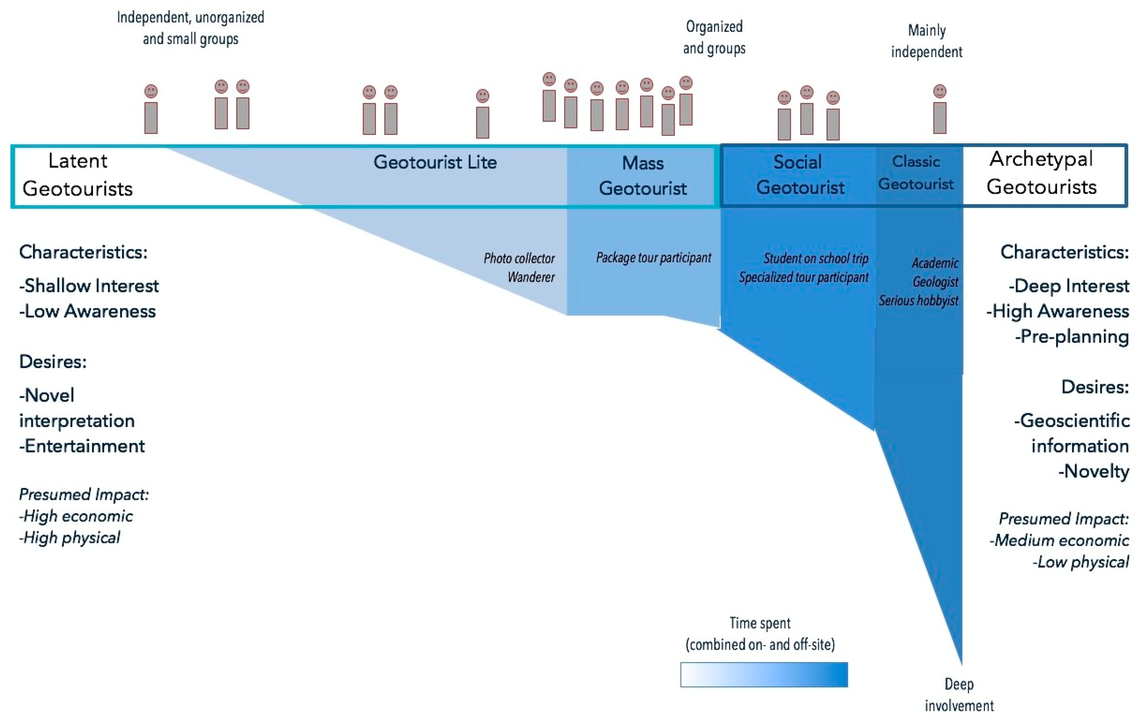
Allocating signs is made easier by recognizing differences inherent in latent and archetypal geotourists. Figure 3 reflects the sum of the literature reviewed. The author suspects that the latent geotourist often steps to the metaphorical shore, as depicted by the shape of the graphic, doing nothing more than snapping a photo [62]. On the contrary, the archetypal geotourist will sometimes go to extreme depths in terms of absorbing technical information, spending hours making observations about the geosite both off- and on-site, if resources are obtainable. We can go forward assuming both latent and archetypal geotourists enjoy novel on-site interpretation, but the archetypal geotourist will probably avoid peak times and need less management at the destination. A spectrum capped by novelty and knowledge is depicted by the depth of involvement with the geosite [62]. The width of the fields is proportional to the number of each type expected to be encountered. The category colors correspond to the estimated length of time spent engaged with the geosite. When combined with group size, we may begin to see a physical impact factor. Scholastic involvement can start to be estimated by time spent researching using materials provided. Again, this is a formative study and the types will need to be verified.
Four conceptual geotourist categories or personas are thus presented, falling under the two aforementioned classes of latent and archetypal geotourists (see Table 2). These hypothesized types depict much of the current literature reviewed here but will be tested for accuracy in the field. The author will now proceed to propound the theoretical sub-types for deliberation.
4.1.1. Geotourist Lite
The first of the postulated types based on the literature is geotourist lite. Traveling independently, in pairs, or small groups, they are mostly interested in a novel experience. The visual aesthetic of the site is the chief motivating factor for a type the author calls the photo collector, a commonly-encountered member of this category. Geotourist lite may stumble upon an attraction but when the promise of a good opportunity for a self-portrait or selfie is available, it will drive them to it. We often hear of the detrimental effects caused when a photo opportunity becomes the visitor’s overriding priority [71]. These sorts of experience-collectors only need to snap a photograph or interact with the site superficially, even just to gaze upon it to feel satisfied by the encounter and cross it off of their list of places [44,54,62,72]. Encouraging this group to use a designated platform for the ultimate selfie or the must-have photo could divert foot traffic from sensitive landforms and vegetation and would be a positive management intervention.
The social media trend may be bewildering to mature generations, but it has the effect of creating interest in geosites through geographical tagging [38,73], which supports the dissemination of majestic landscape photos and must-see places worldwide. Lagally and Loth [74] tell of another type of collecting—geosite collecting—that was inspired by the Bavaria’s Most Beautiful Geosites series [24]. A list of all 100 landforms was entered into the geocaching platform (Geocaching.com is a web platform where caches can be found for fun using geographical tags. Members use GPS coordinates and/or clues to ‘collect’ caches in the geocaching community) [75], precipitating a sort of interactive experience with ‘check in’ capability. This is an area for future investigation, since such a scheme would likely appeal to those active on social media as well as those seeking out postcard-perfect landforms [33].
4.1.2. Mass Geotourist
Geotourist lite and mass geotourists are both latent geotourists because although they are recreating at a geological site, the geology is not generally why they come. Together, they are expected to be the most common types of visitor to geosites [10,54,55,56,64].
The mass geotourist possesses a limited desire for knowledge, low awareness, and a great desire for novelty. They usually move in packs, so the small dip in their section of Figure 3 represents those who grow interested through the exhibits or reflection while waiting for the group to recommence. They may be at a geosite because a pre-arranged tour was part of a package deal or because they are participating in adventure sports such as river rafting or rock climbing [6]. Popular pre-arranged tours are taken to geological sites [6] like the Devil’s Causeway in England, Yellowstone National Park in the United States, or the National Park of Belluno Dolomites in Italy, places of extraordinary geological significance that attract many visitors. These excursions are not typically marketed as geological tours, because even the word geology could drive away the mass geotourist [10,26,45,46,47,48,49,50,76]. At this end of the spectrum, we see the kinds of tourists in whom we want to activate geoconservation awareness. These are tourism consumers [41,42,43,44,54] that make a high ecological impact on the sites due to their sheer numbers, sometimes even straying from paths and causing damage [13,15,16,71].
Together, lite geotourists and mass geotourists are crucial to the typology because latent geotourists are expected to compose at least half of the visitors to geosites [10,54,55,56,64]. They also require more management, different marketing, and unique considerations in terms of interpretation, but catering to them is essential because they ensure a sustainable resource through their strong economic support [6,14,41]. The opportunity to practice the tenets of geotourism, namely, to promote “appropriate minimal-impact behavior, increase the visitor’s awareness of impacts, and foster conservation of the site and promote an interest in geoconservation” [6] is enhanced by having access to this somewhat tricky segment of the population.
4.1.3. Social Geotourist
The social geotourist tends to travel collectively, whether with a club, geological organization, geologist-lead tour, professional outing, or school field trip. They are often scholars or geoscience enthusiasts who come to the site with some geological awareness. Education is a priority, so off-site resources such as academic articles, maps, or other scholarly materials in advance of the visit are usually sought out, but interpretative panels provide welcome talking points for the group [10,50]. Social geotourists may join the scientist-led geological tours or plan excursions of discovery with other hobbyists or geoscientists [14]. The main difference between the social and classic geotourist is that the former is part of a group and can be a reluctant participant but, regardless, the visit is meant to be a learning experience. Like mass geotourist, they have constraints due to the nature of being in a group setting. The impact varies from car loads to bus loads, making the central part of the typography containing social geotourist and mass geotourist the most significant in terms of physical impact. The researcher anticipates varying degrees of impact given the numbers, time spent, and disparity of awareness levels.
4.1.4. Classic Geotourist
The classic geotourist is an anomaly. While similar in many ways to the social geotourist, they are expected to be generally solitary, individualistic travelers, although some indicate they may be more social than anticipated [64]. In stark contrast to the other somewhat independent category, geotourist lite, the classic geotourist does not value sharing travel experiences, socializing, or having access to a wide range of attractions [56]. Their relatively small numbers, lack of infrastructural requirements, and quirky market suggest that they are not very demanding as a group. They have little impact on geosites and tend to have a strong desire for knowledge, seeking more substantive information such as the deep time scales in the Bavaria’s Most Beautiful Geosites series [24] (see Figure 2a). This is a depth that is not advisable to offer on the sign, but better in a brochure, because technical language and specialized texts will alienate latent geotourists or those who do not already possess knowledge [10,26,45,46,47,48,49,50,76] and it is also to have something to take for reference along the trail. This niche [54,56] of dedicated tourists [10] is “a restricted market dependent upon better-educated and wealthier tourists. Their interest in geosites is mainly self-education and intellectual improvement” [5]. Nevertheless, the author theorizes that classic geotourists are essential to cater to because they are most likely to transfer scientific knowledge to others in academia, which can have the effect of creating new resources related to the geosite and help convert others from latent to archetypal geotourists [34,46].
As one might expect, the archetypal geotourist—in contrast to the other independent type, geotourist lite—is well-behaved as a rule, as they are generally aware of geoconservation issues. The reason archetypal geotourists comprise a bit more bulk in the conceptual framework is due to the school groups that make up social geotourists.
4.2. Limitations
The typology is primarily meant to provide a unified overview of existing research enabling geotourism professionals to better anticipate the behavior of target audiences. Its utility lies mainly in helping planners to understand the audience at a glance.
One shortcoming of the typology in its current form that plagues the author is the fact that she knows from experience how the pendulum can swing. There are instances when tourists are in different modes, as in Cohen’s [61] model, like when the wanderer participates in geologist-led tours or when an academic is relegated to the role of photo collector simply because there is no suitable interpretation available. Someone who is really interested in the geosciences can stumble upon a roadside geological trial on a day when driving is the goal, and simply keep driving. There will be crossover between the geotourist types and some ambiguity across the categories presented here. If much overlap is identified, the framework will be adapted to accommodate modes, taking a cue from Cohen [61]. The central part of the typology may also need to be further expanded on given the expected range of physical impacts due to time spent on site, existing interest in geology, and group size. As mentioned previously, there are degrees of serious leisure [59] that may call for more scrutiny.
Falk and Dierking’s free-choice learning and contextual model of learning is a fruitful area to probe into the behavior of visitors at geosites [32,52,53]. It has not yet been applied directly to geotourism settings, but Packer and Ballantyne make noble progress toward that effort [30] and their study shows promise. As the researcher begins to look at interpretation through a learning lens, Falk and Dierking’s work on the outcomes and benefits of interpretation will undoubtedly yield invaluable knowledge as she writes her dissertation.
The author can only postulate the marketing and tourism management challenges latent tourists present to geosites. Ritchie and Crouch [41] established four criteria to consider in the sustainable planning of a destination, specifically nature of demand (audience desires), time of demand (high season), the magnitude of demand (consider site size before attracting a market), and future demand. At the same time there are calls for “demarketing” to actively attract low-impact niche tourists [22]. While the author is well acquainted with tourism marketing and management, they are outside of the scope of the paper. The implications of poor tourist management and marketing (vandalism to sites, economic unsustainability) are generally more detrimental than inferior interpretation (no one reads the signs, awareness is not increased), which is why they are necessary to assess here, even if in a passing manner.
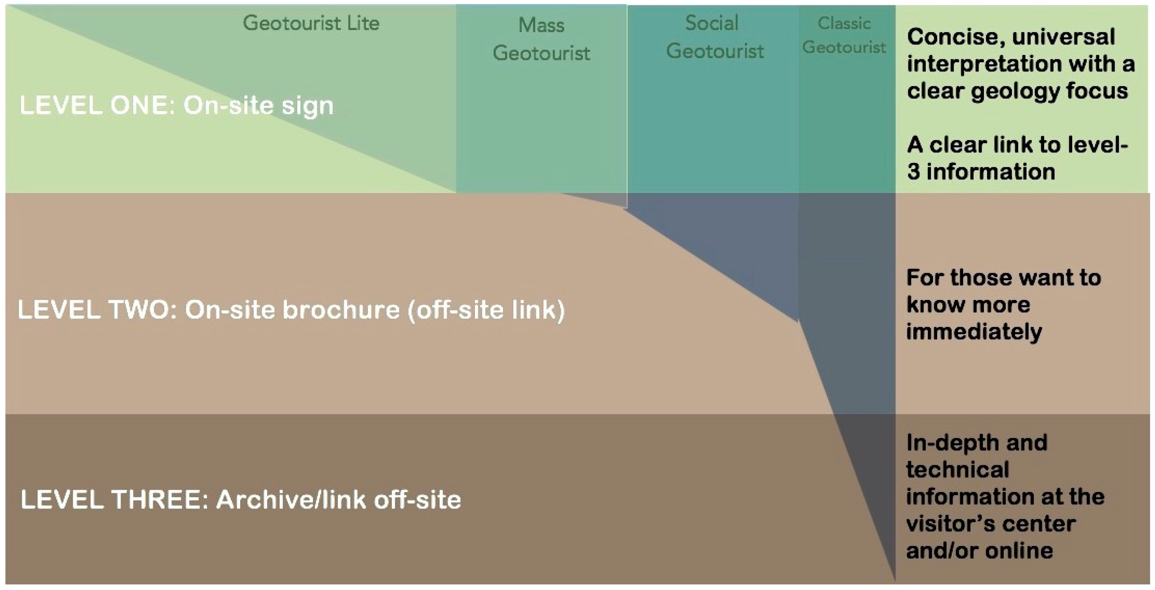
4.3. Interpretive Strata
A visualization is presented in Figure 4, forming a starting point for planners of interpretation, and aiding in the development of content for target audiences. At Level 1, one should encounter an interpretive sign with universal appeal that is thematic, entertaining, creates excitement about geology, and leaves one wanting more. If one is still curious, a brochure that is affixed to the sign or available at the tourist center or online (Level 2) would be ideal [26]. As mentioned, the author envisions a brochure that resembles those in the Bavaria’s Most Beautiful Geosites series [24] because it offers a lot more information immediately for those whose interest is piqued. Also, one does not need a phone or a data plan to access more facts; an important consideration for international visitors. For those with deep interest who research in advance, a website or archive provides a wealth of peer-reviewed resources (or bibliographies), maps, and other technical sources (Level 3). Preferably, these are also at the visitor’s center or tourist office.
5. Discussion
Facilitating Experiences Congruent with Expectations
Geomorphological landscapes such as that surrounding Mount Dobratsch fill one with awe but also possess the appeal of both colossal landforms that stir the imagination and tangible objects on the ground. To the uninitiated, it feels like driving through a disaster film that someone put on pause. Boulders the size of compact cars litter the side of the road, jagged and seemingly freshly thrown. The craggy face high above, blushing like an infant, stares back, powdered and pink; the awkward form supporting it looking as if it will topple any moment. In Carinthia, it seems, the mountains not only call—they come! The relatively-recent earthquake creates a sort of living lab of not-so-deep time where one can witness the remnants of the shores of a lake created by the subsequent rockslide and see a landscape that looks as though it is still in motion. A platform situated on a scenic route to the top gives one a dramatic panorama of the site (see Figure 5) and also informs of the dramatic way that the mountain tragically changed the lives of the people under it forever while simultaneously creating life in the form of new habitat [77]. Answers to geoscientific questions abound today, but our friends in 1861 had none as they traversed Gail Valley.
Universal themes and personal accounts help create meaning for visitors [11]. On a brochure, [77] the local abbot’s harrowing ordeal stirs the imagination [78] (p. 7) “in the bright sun, suddenly, in a firmament covered with dark clouds, an appalling earthquake [...] since the times of our Lord’s likeness never heard before, still felt until then, have to experience, feel and see for themselves in the strange district of the monastery. For Mount Dobratsch, on the Villach Alps, just opposite only an hour away and on the midnight side, suddenly buried 17 villages, 3 castles and 9 churches in ruins” [78] (trans. from German by author).
This verse links cultural and natural realms [11] as well as universal motifs like change, fear, and destruction that speak to anyone and engage audiences [48,49,50,51]. The text goes on to say the earth shook so violently that the church bells tolled themselves mad as if they were of the opinion that it was the last day on earth [78]. Passages like this can be wielded to marvelous effect, drawing visitors in—both specialists and laymen—so that we may capture their interest and then present them with a palette of options. The author hence agrees that “perhaps one of the aims of exhibit design and interpretation should be to give visitors tools and resources that will enable them not only to construct their own meaning, but also create their own story, which they may then report to others” [30]. The author suggests some will report visits through graphic depictions of otherworldly vistas, others may produce research based on what they see in the field, and some may do both. Providing tools widens the visitor’s prospects.
Recreation is at the core of geotourism, therefore benefits such as flow—the feeling of losing oneself in an activity [79]—are central to the experiences planners strive to deliver. Conditions of flow occur when one feels challenged enough by an activity to not feel bored, yet not so challenged as to feel inept; in short, when ability and skill are in harmony [79]. To illustrate this with a sign, the use of jargon may be mentally stimulating for a classic or social geologist, but it could repel a latent geotourist with no familiarity of geoscience, making them feel incompetent [10,45,46,47,48,49,50,76,79]. On the contrary, a classic or social geotourist may feel pandered to when issues of geoconservation are preached, or when universal interpretation obfuscates all discernable signs of geology [32].
6. Toward Signs and Interpretive Exhibits
6.1. Archetypal Geotourist: Information Seeking
It is fortuitous that archetypal geotourists tend to source information before arriving at the site [10,54,67] because the provision of populist interpretation becomes easier. They also crave personal development, a sense of accomplishment, self-respect, ego-enhancement [66], and usually dislike crowds [53,67]. As noted, they do appreciate panels on site, but want more information, thus adding a small technical portal that links to advanced resources would be welcome [26].
The Carnic Alps Geopark in Austria [80] provides links to research oriented toward scholars and specialists [81], other geoparks in Austria [82], a list of geology books specific to the region [83], and geological information for tourists and novices [84]. The visitor center in Dellach is dedicated primarily to geology and is full of interactive stations and specimens [85]. There truly is something for everyone. Many tools are furnished to construct one’s own unique experience.
In Germany, the excellent, albeit didactic, series of geological signs, Bavaria’s Most Beautiful Geosites, [24] (see Figure 2a) links one directly to the website of the Bavarian Environmental Protection Agency. It contains an even more extensive archive of geoscientific data, including interactive maps and high-definition versions of the exhibit panels, making them available to anyone [24]. The website also leads to peer-reviewed texts, enabling researchers to study local geology in depth. It is a veritable treasure trove. A list of unique geosites in Germany [86] is the type of information that classic geotourists would use to map out a trip.
Naturally, everyone can benefit from the materials arranged for scholars when made available at the visitor or tourist center or on the website. Some academic material will not be obtainable due to subscription restrictions, but bibliographical lists or links to book-purchasing options are helpful points of departure.
6.2. Latent Geotourist: Novel Interpretation
Interpretation at this end of the spectrum should be entertaining, not full of facts. Signs should entertain, spark curiosity, provoke interest, and even empathy when effective [22]. Latent geotourists desire little depth and are novelty-oriented [10,13,56,64,66] gravitating toward text that plays to the imagination [10]. For example, “the Matterhorn is like a sandwich made of Africa and Europe” or “only one little church, St. Magdalen, remained standing, where even a flock of sheep was so happy to be rescued that their footsteps can still be seen there today” (p. 7) [78] (trans. from German by author]. Most latent geotourists are unaware of geoconservation issues, cannot use maps, and lack basic geoscientific knowledge [10] so topics must be chosen carefully as not to drive them away. Fundamentally, we want visitors to read the signs in the first place, otherwise what they say is fully inconsequential.
Writing well-crafted prose results in a high return on one’s effort, or what Thompson and Bitgood [46,47] call high value ratio; in short, an attention-capturing sign worth stopping to read. Research shows that shorter signs (60–150 words) [45,46,47,48,49] that exhibit the retention-boosting practice of chunking [46,47,87], are written at a 13-year-old reading level [10,26], and contain ample white space [88,89,90] will be read by more people; therefore, planners should curate their text. If every fact is included, most people will not stop to read the interpretation [45,46,47,48,49]. Furthermore, if a sign is short, the public will read it even if they are not interested in the topic [46]. Iconic designer of the famous United States National Parks Service series [91] Massimo Vignelli declares, “In a world where everybody screams, silence is noticeable” [90].
A lack of planning can contribute to a worrying trend that the author has come to call the ‘Schilderwald’ (sign forest) effect. This happens when an accretion of informational boards, from disparate eras and with inconsistent visual styles, form a hodgepodge of objects that compete for attention. Signs are continually added in an attempt to please everyone and cover every topic. At one particularly small but highly-popular geosite outside of the Alps, five signs containing more than 1500 words total and several other random signs crowd the tiny locale. Another popular Alpine along the road accumulates signs every year; 10 years ago, there were only two signs. These “forests of signs” are repellant and disturb the landscape. Most relevant to the matter at hand, and as we see repeatedly in the literature, these long signs go mostly unread [44,45,46,47,48,49,65,74]. Hose even found that three-quarters of visitors to his site ignored or barely scanned signs [10]. We have limited time to communicate because many visitors will move on if they see too much text [10,45,46,47,48,49,65]. Therefore, it is necessary to plan for the extra temporal cost and effort required to write text that is curated and concise [46]. This is the planner’s cost to bear, not the reader’s, because it can literally stop people from reading what one wants to convey. If no one reads the sign, it does not matter what it says. Too often communities struggle to maintain accuracy while putting information into layman’s terms [48,74] or, worse, they try to fit every bit of information at the geosite. In practice, the holistic ABC approach, which requires the inclusion of abiotic, biotic, and cultural attractions [10], can result in loquacious and demanding signs if a framework is not employed.
Interpretive design is equal parts art and science and has been touched on very briefly in this study: one only need look at Vignelli’s scheme for the National Park Service [92] to see that when it is done well it is a complex affair. This is before the interpretive text is crafted, which is an art in itself [36,49,50]. Creating a cohesive visual style adds a recognition factor [74] that translates across markets. Mapping signs in a consistent manner enables one to navigate them automatically, eliminating struggle [93] from what should be a leisurely episode. Naturally, anyone with knowledge of an attraction can create a sign. Indeed, this is often what happens in communities when resources are exhausted or one does not know where to turn for assistance. Techniques and tools to improve and design signs will be explored further in an impending paper.
Beck and Cable [50] and Ham [49] agree that interpretation can enhance conservation efforts. The ABC approach to geotourism is a suitable introduction to geology for the general public because it has something for everyone [10,11,26] and is even mandated by most European countries’ geoheritage guidelines [22,94]. Gordon [3,11] makes an especially convincing case for holistic interpretation that inspires wonder about landscapes. In an informal learning environment, meaning is personally constructed [29,30,31,32,33,34,35,52,53]. A robust and accessible archive of off-site materials such as scientific articles, technical reports, and curriculum guides should cater to academics [10,26,54], while entertaining panels attract tourists with the end goal of geoconservation and increased awareness [6,10,29].
7. Future Research
The author is currently conceptualizing tools for geological interpretation for geotourism purposes. One of these tools will be used to quickly score the value ratio [46,47] of existing signs to determine their probable attracting and holding power, pointing stakeholders toward interventions that match their requirements. Bitgood’s attention–value model, which measures capture, focus, and engagement [46] will be adapted for an outdoor setting. For instance, by applying it, one should be able to demonstrate that a particular ratio tends to earn more notice for signs. Some planners will want large, verbose signs with many photos at the cost of attention capture because “no matter how much data you show some people, they won’t accept the predictive power of the value ratio” [46]. Still, the tool should help them achieve a balance that suits their personal requirements.
An interpretive template that embodies best practices derived from the literature will also be designed to experiment with existing signage. The interpretive template allows one to plug in their own information and photos, and then produce a sign. It will have built in fields with parameters for length, photo size, and alignment to make it user friendly. A rough sketch can be seen in Figure 6. The sign generally reflects best practices described (e.g., a fetching title [65], a text count of around 60 words per chunk [46,47,87], plenty of white space [88,89,90], attention to alignment and hierarchy [28,88,89,90], and a link to outside resources [26,74]). The author is not a graphic artist, so an expert will be consulted before the template is put to use. Graphics are important [10,28,88,89] but often taken for granted because, even though we live in a visual culture, most lack visual literacy [28]. Many geotourism sites provide excellent options in terms of content, but these choices get lost in exhibits that require a bit more attention to aesthetic qualities. The grammar of visual design does not change [88], but not everyone can speak it.
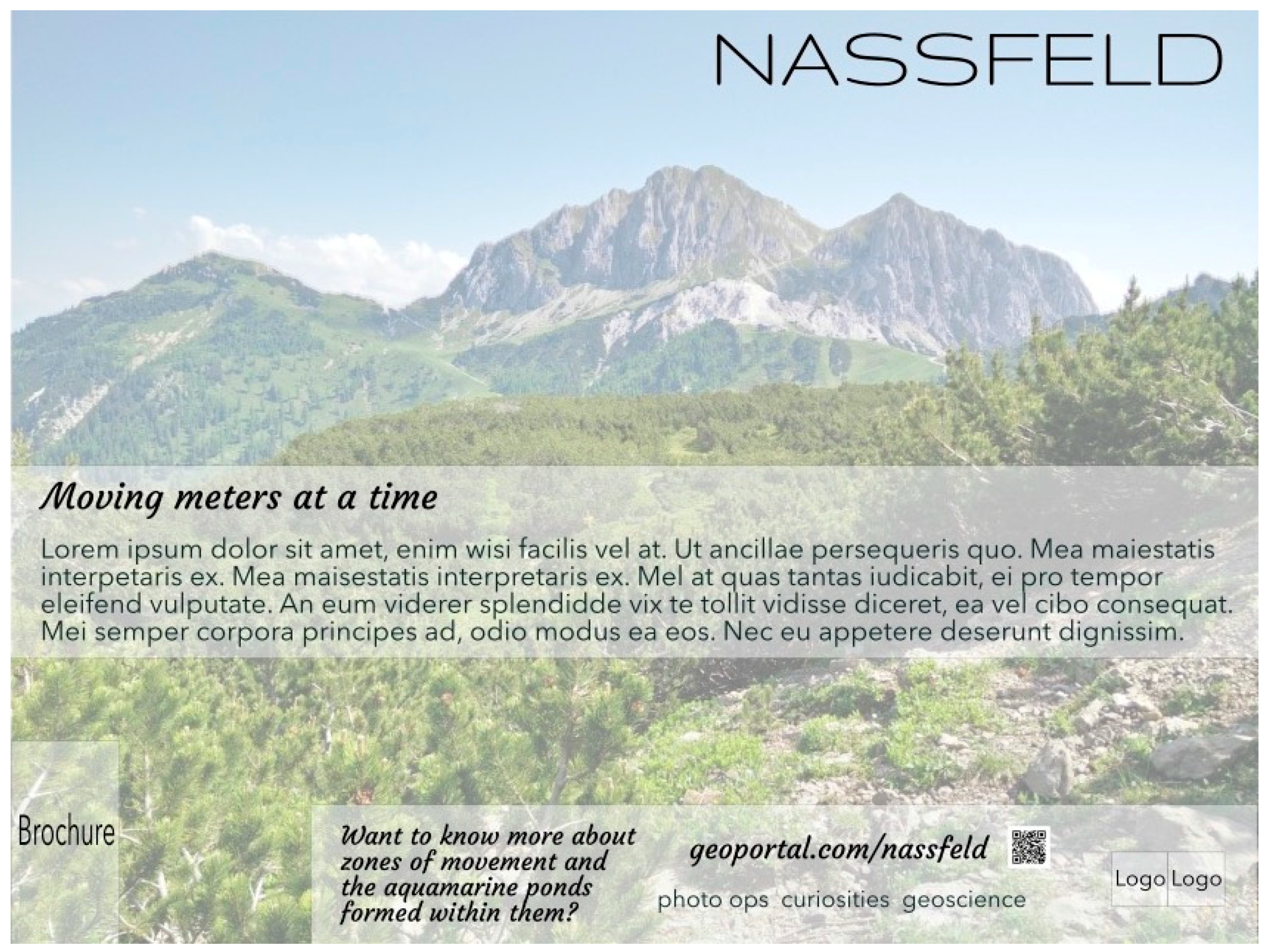
A second example was created to demonstrate the new theoretical approach in an introductory manner. The author has perhaps expressed sufficient reverence for the Bavaria’s Most Beautiful Geosites series [24] to be allowed the latitude to use a sign from it (see Figure 2a) to explain. The sign in Figure 7 represents Level 1 of the interpretive strata (see Figure 4) is easy to read, attracts attention, and inspires curiosity [46]. If one wants more information, one moves on to Level 2. At Level 2, a brochure that resembles the signs of the Bavaria’s Most Beautiful Geosites series [24] is optimal if the author’s assessment of the audience’s expectations is correct. The brochure can be accessed from the website. A smartphone application (or ‘app’) may also be devised in the future. Level 3 represents academic information: a link to the website that is easy to find both on-site and off. It will furnish one with an archive of technical information, maps, and other research-related materials via a short link or scannable code. Other non-technical information or materials related to biology or culture can also be accessed here.
After the initial testing of a few extant geosite signs for their attracting and holding power, their text will be honed and shaped to insert into the new template in development. A panel will be printed, and the attracting and holding power will be tested again to see if the intervention improves the sign. Preliminary details of how this will be accomplished are provided in Appendix B.
Collecting data in the field and integrating further research in an iterative process will make the framework stronger. In gauging visitor desires, employing a mixed methods approach that includes the collection of quantitative data to determine whether actual behaviors (not self-reported) are carried out before, during, and after the trip (e.g., monitoring associated websites for searches made, photos posted to social media on-site, geographical tagging at geosites) should yield felicitous results on actual geotourist behavior. The result will be a multidisciplinary geotourist typology that is well-informed, is applicable to a diverse range of uses, operates from several perspectives, and considers every aspect of the geotourist, including how to entertain, teach, attract, and manage them.
8. Conclusions
The author’s overriding goal is to refine the mechanics and format of signs to garner maximum attracting and holding power, ensuring that the message chosen by local planners and stakeholders is read and the target outcome is achieved. Geology should also play a prominent role because abiotic features need to be treated with admiration and respect [6,10,11,12,24,26] to ensure their preservation.
Geotourism practitioners do not command a captive audience. Geotourists are invariably in a recreational setting in which they are free to choose whether to learn about the landscape they are visiting and most of the time they will not bother to do this if they feel the time investment to read a sign is too high [10,44,45,46,47,48,65]. Expecting the audience to read complicated signs in a recreational setting is imprudent, particularly when they have no cohesive visual style and one has no idea how they ‘work’. When panels have a consistent layout, one knows just what to expect every time. One has their favorite sections that they tend to gravitate to and absorbing them becomes the focus, not finding them in the first place. Creating a house style of geotourism interpretation, such as what Hose recommended, Ref. [10] would result in a coherent universal geotourism identity, imparting it with recognizability and thus greater visibility while facilitating navigation and adding aesthetic appeal [88,90].
In the 1990s, the company OXO launched the Good Grips line of kitchen easy-to-hold devices with a product created for those who had difficulty grasping things [95]. The utility of the universal design birthed a new audience for the entire line and many people sought them out for primarily aesthetic reasons [96]. This principle can be applied to the interpretive concept. When we dazzle the audience with a visually-appealing and interesting sign that they come to recognize and get what they want out of, they may seek them out because they are entertaining and informative, even if they never appreciated geology before [46]. Creating a house style that is embraced by a wide audience is the second overriding goal of this endeavor, albeit an ambitious one that requires collaboration. Ideally, a network of universities and other organizations in the Alps will link together as a step toward building an archive of scholarly information derived from geotourism sites, strengthening the geoscientific profile of these highly-visited tourist destinations.
On a practical level, small signs are quicker and cheaper to produce. Site managers deal with the realities of vandals, harsh weather, and wear and tear to infrastructure [26,48], but this tack makes them easier to replace and update. One can also exercise ABC-style interpretation because the signs are small enough to be used in congress. Theoretically, each abiotic, biotic, and cultural-heritage-themed sign can link to its own related resources (e.g., university, arboretum, museum). There are many possibilities inherent in its simple but versatile design. Ideally, signage should also provoke, raise awareness, create meaning, and facilitate learning [35,48,51], but that is an area for future research related to communication, interpretation, and its outcomes.
Markets that want to attract geotourists and do not know where to start can benefit from a sign template into which they can easily add thoughtfully composed local information. Presently, the interpretive scheme is being worked on with isolated geosites and smaller communities in mind where it is the sole interpretive product, creating an attraction where one did not exist. The field of geotourism can benefit from enhanced recognition, particularly if a website links all of the available information [26,74] and the signs become familiar. Testing and input from relevant professionals (e.g., graphic artists, informal-education researchers) will give it broader applicability and lead, conceivably, to implementation.
Gorman [55] suggests that geotourism can either be primarily focused on the geological product or it can be focused on the markets that potentially may find this type of product attractive (in other words, the tourists). However, the author sees a way to focus on both. It is suspected that some of the contention over the sharing of the term geotourism is due in part to practical reasons. What is proposed here is, in some ways, the adoption of a middle ground. Just as there is a need for the conveyance of geoscientific information, there is also a need for sustainable geotourism planning and management in service of geoconservation [24,41,67]. The implementation of signage that appeals to every geotourist can bring a measure of unity to the splintered field of geotourism in which some want a geoscientific focus and others want blended abiotic-, biotic-, and culture-themed signs that can obscure geoscience information. A balance is required between conservation and development [14,54] at geosites because among them lies a symbiotic relationship. That means catering to everyone who visits because, without visitors, some geotourism sites may not continue to be economically viable.
Funding
This research received no external funding.
Acknowledgments
I would like to thank my advisor at Clemson University, Robert Bixler. His advice on my research in leisure behavior and geological interpretation was invaluable and his encouragement continues to motivate me. I would also like to thank my reviewers. Their comments were extremely useful in helping me to frame the study.
Conflicts of Interest
The author declares no conflict of interest.
Appendix A

Table A1.
An Overview of the Literature Describes the General Placement of Select Texts within the New Conceptual Framework.
Table A1.
An Overview of the Literature Describes the General Placement of Select Texts within the New Conceptual Framework.
| Geotourist Types/Market Segments | Brief Notes on Methodology and Results | Comments | |
|---|---|---|---|
| Cohen (1979) [61] | Five modes of tourists: recreational, diversionary, experiential, experimental, existential | A seminal conceptual framework based on the pursuit of pleasure versus the quest for meaning is posited. Generally speaking, it is about the tourist’s search for the novel versus the journey to the authentic. | This general tourist typology remains apt with ‘recreational’ and ‘diversionary’ modes lending insight into latent geotourists and ‘experiential’, ‘experimental’, and ‘existential’ modes illuminating archetypal geotourists. |
| Hose (1998; 2000) [10,63] Hose (2003) [97] | Dedicated (academic) Casual (populist) Intellectually engaged Physically active Socially involved | Hose, an early expert in geotourism, devises a typology based on observations at his site. His model contrasts desired levels of interpretation (academic/populist) against format (off-site journals, on- and off-site panels). He adds the verbiage dedicated and casual (2000), reflecting the types of geotourists who want academic and populist interpretation, respectively. This early paper posits what may be the first geotourist typology and remains highly useful. Hose updates his typology as part of his Ph.D. thesis with a three-sided model adding the personifications of socialite, dilettante student (i.e., intellectually engaged-physically active), photographer and hiker (i.e., intellectually engaged, socially involved), sage, clerk, aloof leader, and private collector (i.e., socially involved, physically active). Clustered centrally in his model are the generalized personifications of the social collector, student, sociable leader, diligent student, and hammerer (i.e., a fossil or mineral enthusiast). | Highly intellectual, ‘dedicated’ geotourists hand select geosites for the purpose of education and knowledge expansion and the ‘casual’ geotourists are those who occasionally visit geosites mainly for recreation, pleasure, and some limited intellectual stimulation. This was the basis for the author’s original formulation of the latent and archetypal geotourist categories. The updated version of the typology affords less utility for the author’s purposes. Still, the personifications inform the overall framework generally and the classic geotourist (academic) specifically. His personifications may be added after data collection if deemed appropriate. |
| Mehmetoglu (2004) [66] | Collectivistic Individualistic | Group and solo visitors (collectivistic and individualistic) to a Norwegian destination of geological significance are studied. Mehmetoglu found that organized tourists opt for idle entertainment, not personal enlightenment in contrast to personal goal-oriented individualistic tourists. Surprisingly, although they are referred to as collectivistic, socializing is not as important as one might expect: novelty is more important to collectivistic tourists than social interaction. It should be noted that novelty is undeniably important to both types. | Although the study does not explicitly mention geotourists, it supports anecdotal and other scholars’ philosophies on geotourist habits. Understanding geotourists’ preferences for organized or independent travel helps inform ecological impact, openness to socializing and/or crowds, and pre-planning and tells us about mass tourist behavior. |
| Falk (2006) [62] | Four visitor identities: 1 explorer, facilitator, professional/hobbyist, experience seeker | Visitors to a science center in California are interviewed about their motivations, and content analysis revealed five visitor identities. ‘Explorer’ is the curiosity-based type with a thirst for knowledge; the ‘facilitator’ is motivated by push factors (i.e., the demands of others); the ‘professional/hobbyist’ seeks a deeper intellectual experience; and the ‘experiences seeker’ is an experience-collector. | The ‘explorer’ fits the latent geotourist and within that class, the ‘professional/hobbyist’ reflects the classic geotourist who wants a deeper experience. The ‘facilitator’ supports the mass geotourist and the ‘experience seeker’, describes geotourist lite well. Falk’s types can be distributed remarkably evenly throughout the typology, which the author discovered after devising her typology, and it lent a measure of legitimacy to its design. |
| Mao et al. (2009) [67] | Potential geotourists | In this preliminary study to inform destination development, marketing needs, visitor behavior, and geotourist preferences, members of the Geological Society of Australia (GSA) self-reported on their purpose for travel (i.e., to gain knowledge, to satisfy curiosity) in addition to their likelihood of travelling independently to geosites. | While Mao et al. do not explicitly posit types, their examination of members of the GSA contributes to wisdom about archetypal geotourists and is concomitant with Hose’s [63] findings. |
| Grant (2010) [56] | Geo-expert Geo-specialist Geo-amateur Interested visitor Aware visitor Unaware visitor | Grant’s is a conceptualized pyramid-based model based on prior knowledge, interest, and expertise. The posited typologies are gauged through a marketing lens. Depth of interpretation increases near the top of the pyramid as does expected audience size. The base represents those interested in novel entertainment. | Her ‘interested visitor’ and ‘aware visitor’ categories represent the latent geotourist with the highest market potential and entertainment requirements. Her ‘geo-expert’, ‘geo-specialist’, and ‘geo-amateur’ are degrees of archetypal geotourists: a small, knowledgeable group with limited market potential. Her ‘unaware visitor’ stumbles upon a geosite, like geotourist lite might. Having a marketing background, she points out the advantages of pinpointing the most common types of geotourists in order to better cater to them and theorizes the market can be grown through interpretive interventions. |
| Hurtado et al. (2014) [64] | Purposeful Intentional Serendipitous Accidental Incidental | Hurtado et al. applied McKercher and du Cros’ [98] cultural tourism typology model to cave tourists at a National Park in Australia, so both latent and archetypal geotourists are part of the subject group. Five types are described based on motivation (i.e., curiosity or education) and positive or negative experience. However, the researcher perceives a gap at the depth of experience end of the spectrum where ‘to know more’ can put the archetypal geotourist on the same footing with a latent geotourist. Quantitative assessment of actions taken before the visit may be a better indicator than self-reported motivations. | ‘Serendipitous’ and ‘accidental’ geotourists reflect postulated geotourist lite (latent geotourists) and ‘purposeful’ and ‘intentional’ geotourists are similar to archetypal geotourists. The ‘incidental’ geotourist is omitted from the author’s study because she sees limited use in adding this negative-experience group straightaway. This was one of the most useful studies in terms of formulating the original framework proposed in this paper. They also refer to Mao et al.’s study [67], adding to its relevance. |
| Božić & Tomić (2015) [54] | General geotourist Pure geotourist | To arrive at tourist values, visitors to several gorges in Serbia self-report their motivations for visiting via a questionnaire. Previous geological awareness was also considered. Their detailed evaluation considers many indicators, some that concern the physical, aesthetic, and interpretative aspects of destinations. Other factors related to infrastructure round out the study, which reflects a tourism marketing perspective that stresses geoconservation. | Their ‘general geotourist’ strongly supports the author’s latent geotourists and their ‘pure geotourist’ reflects archetypal geotourists with their penchant for planning (research in advance), avoidance of crowds, and knowledge-seeking tendencies. |
1 The fifth type was omitted because only one subject out of the sample of 52 personified the ‘spiritual pilgrim’.
Appendix B
Table A2.
Preliminary Data Collection Plan to Test Existing Signs and the Tools Being Developed to Check Their Attracting and Holding Power and Facility to Appeal to a Broad Audience. Conceptual Geotourist Categories Will Also be Tested.
Table A2.
Preliminary Data Collection Plan to Test Existing Signs and the Tools Being Developed to Check Their Attracting and Holding Power and Facility to Appeal to a Broad Audience. Conceptual Geotourist Categories Will Also be Tested.
| Subjects | Factors to be Quantified and Qualified | Methods | Objectives |
|---|---|---|---|
| A selection of geosite signs in and near the Alps | Number of words Number of topics Word types (technical, thematic) Links to academic-quality information Focus (abiotic, biotic, cultural) Composition * (alignment, contrast, white space) Aesthetic appeal * (well-chosen photos, timeless) Display (already vandalized, easy to replace) | Primarily quantitative (content analysis) | Improve attention capture by determining perfect ratio Determine how much geology focus at geosites See if the public uses links to find geoscientific information off-site |
| Sign viewers | Attracting power (% of audience engagement) Holding power (% of audience sustained interaction) | Primarily quantitative (unobtrusive observation) | Gauge audience engagement with signs |
| Geotourists | Pre-planning tendency Obtainment of books (specialized field guides or touristic) Sourcing of information in advance (practical or technical) Existing geoscience awareness Time spent on- and off-site | Mixed (interviews, keyword analytics, observations, and surveys) | Confirm or adapt the visitor types postulated in the conceptual geotourist typology Determine if they can identify landforms and processes Estimate ecological-impact factor using temporal and behavioral (group versus solitary) data |
| Conceptual sign template | Attracting power (% of audience engagement) Holding power (% of audience sustained interaction) Sourcing of information in advance (practical or technical) Brochure taken/looked at | Mixed (observation and keyword analytics) | Did the intervention improve public engagement? |
* These can be said to be subjective variables. Photographs will be presented along with support from the literature to back findings.
References
- Gilbert, J.; Churchill, G.C. The Dolomite Mountains: Excursions through Tyrol, Carinthia, Carniola, & Friuli in 1861, 1862, & 1863; Longman, Green, Longman, Roberts, & Green: London, UK, 1864; Available online: https://archive.org/details/dolomitemountai00churgoog (accessed on 1 September 2018).
- Bonnard, C.; Forlati, F.; Scavia, C. Reppwand-Oselitzenbach landslide. In Identification and Mitigation of Large Landslide Risks in Europe: Advances in Risk Assessment; CRC Press: Piemonte, Italy, 2004; Available online: https://www.researchgate.net/publication/265493186_Reppwand_-Oselitzenbach_Landslide (accessed on 1 September 2018).
- Gordon, J. Geoheritage, geotourism and the cultural landscape: Enhancing the visitor experience and promoting geoconservation. Geosciences 2018, 8, 136. [Google Scholar] [CrossRef]
- Tourtellot, J. UNESCO’s Geoparks ‘Clarify’ Geotourism. National Geographic. 2011. Available online: https://blog.nationalgeographic.org/2011/11/16/unesos-geoparks-clarify-geotourism/#disqus_thread (accessed on 15 August 2018).
- Hose, T.A. Three Centuries (1670–1970) of Appreciating Physical Landscapes; Geological Society, London, Special Publications: London, UK, 2016; Volume 417, pp. 1–23. [Google Scholar]
- Dowling, R.K.; Newsome, D. Geotourism: The Tourism of Geology and Landscape; Goodfellow Pub.: Woodeaton, UK, 2010. [Google Scholar]
- Ji, Y. Sustainable Tourism Can Advance Global Development, UN Agency Highlights on World Day. United Nations. 27 September 2017. Available online: https://news.un.org/en/story/2017/09/567262-sustainable-tourism-can-advance-global-development-un-agency-highlights-world (accessed on 3 August 2018).
- National Parks Service. NPS Stats: National Park Service Visitor Use. U.S. Department of the Interior, National Parks Service. Available online: https://irma.nps.gov/Stats/ (accessed on 1 July 2018).
- IMFBlog. International Monetary Fund. 14 August 2017. Available online: https://0-blogs-imf-org.library.svsu.edu/2017/08/14/chart-of-the-week-icelands-tourism-eruption/ (accessed on 1 July 2018).
- Hose, T.A. European “Geotourism”—Geological interpretation and geoconservation promotion for tourists. In Geological Heritage: Its Conservation and Management; Barettino, D., Wimbledon, W.A.P., Gallego, E., Eds.; IGME: Madrid, Spain, 2000; pp. 127–146. ISBN 84-7840-417-1. [Google Scholar]
- Gordon, J.E. Rediscovering a sense of wonder: Geoheritage, geotourism and cultural landscape experiences. Geoheritage 2012, 4, 65–67. [Google Scholar] [CrossRef]
- Hjort, J.; Gordon, J.E.; Gray, M.; Hunter, M.L. Why geodiversity matters in valuing nature’s stage. Conserv. Biol. 2015, 29, 630–639. [Google Scholar] [CrossRef] [PubMed]
- Kim, S.S.; Kim, M.; Park, J.; Guo, Y. Cave tourism: Tourists’ characteristics, motivations to visit, and the segmentation of their behavior. Asia Pac. J. Tour. Res. 2008, 13, 299–318. [Google Scholar] [CrossRef]
- Newsome, D.; Dowling, R.; Leung, Y. The nature and management of geotourism: A case study of two established. iconic geotourism destinations. Tour. Manag. Perspect. 2012, 2, 19–27. [Google Scholar] [CrossRef]
- Barrie, J. A 320 Million-Year-Old Balancing Rock Formation Was Destroyed by a Group of Young People. Available online: https://inews.co.uk/news/brimham-rocks-damaged-yorkshire/ (accessed on 1 June 2018).
- Tang, F. Chinese Tourist Destroys with Three Swift Kicks What Nature Took 3000 Years to Build. South China Morning Post. 2 June 2017. Available online: https://www.scmp.com/news/china/society/article/2096657/chinese-tourist-destroys-three-swift-kicks-what-nature-took-3000 (accessed on 1 July 2018).
- Whitcomb, D. Boy Scout Leaders Topple Ancient Rock Formation, Trigger Outrage. Scientific American. Available online: https://www.scientificamerican.com/article/us-scout-leaders-topple-ancient-roc/ (accessed on 1 July 2018).
- “Helft mir, ein Paradies zu Bleiben.” [“Help Me to Remain a Paradise.”]; Das Magazin des Deutschen Alpenvereins: Munich, Germany, 2018; p. 10.
- Hunter, D. The Trump Administration’s Effect on National Parks: It’s Been a Hard Summer for Our Public Lands. Scientific American. 28 August 2017. Available online: https://blogs.scientificamerican.com/rosetta-stones/the-trump-administrations-effect-on-national-parks/ (accessed on 1 August 2018).
- Nordhaus, H. What Trump’s Shrinking of National Monuments Actually Means. National Geographic. 2 February 2018. Available online: https://news.nationalgeographic.com/2017/12/trump-shrinks-bears-ears-grand-staircase-escalante-national-monuments/ (accessed on 18 July 2018).
- Stokes, A.M.; Cook, S.D.; Drew, D. The New Trend in Travel. Travel Industry Association of America and the National Geographic Traveler Magazine. 2003. Available online: http://www.egret.us/clinton/Geotourism%20The%20New%20Trend%20in%20Travel.pdf (accessed on 15 August 2018).
- Hose, T.A. 3G’s for modern geotourism. Geoheritage 2012, 4, 7–24. [Google Scholar] [CrossRef]
- Milano, C.; Cheer, J.M.; Novelli, M. Overtourism: A Growing Global Problem. The Conversation. Available online: https://theconversation.com/overtourism-a-growing-global-problem-100029 (accessed on 1 July 2018).
- Dowling, R. Geotourism’s global growth. Geoheritage 2010, 3, 1–13. [Google Scholar] [CrossRef]
- Bayerisches Landesamt für Umwelt [Bavarian Environmental Protection Agency]. Geologie: Tiefe Einblicke in den Untergrund [Geology: Deep View into the Underground]. Available online: https://www.lfu.bayern.de/geologie/index.htm (accessed on 1 July 2018).
- Clary, R.M.; Wandersee, J.H. Lessons from US fossil parks for effective informal science education. Geoheritage 2014, 6, 241–256. [Google Scholar] [CrossRef]
- Larwood, J.; Prosser, C. Geotourism, conservation and society. Geol. Balcanica 1998, 28, 97–100. [Google Scholar]
- Rodriguez Estrada, F.C.; Davis, L.S. Improving visual communication of science through the incorporation of graphic design theories and practices into science communication. Sci. Commun. 2015, 37, 140–148. [Google Scholar] [CrossRef]
- Barrow, G.C. Interpretation planning and its role in sustainable tourism and visitor management at geoheritage sites. Int. J. Geoherit. 2013, 1, 30–38. [Google Scholar]
- Packer, J.; Ballantyne, R. Conceptualizing the visitor experience: A review of literature and development of a multifaceted model. Visit. Stud. 2016, 19, 128–143. [Google Scholar] [CrossRef]
- Wöran, B.; Arnberger, A. Exploring relationships between recreation specialization, restorative environments and mountain hikers’ flow experience. Leisure Sci. 2012, 34, 95–114. [Google Scholar] [CrossRef]
- Falk, J.H.; Storksdieck, M. Science learning in a leisure setting. J. Res. Sci. Teach. 2009, 47, 194–212. [Google Scholar] [CrossRef]
- Falk, J.H.; Ballantyne, R.; Packer, J.; Benckendorff, P. Travel and learning: A neglected tourism research area. Ann. Tour. Res. 2012, 39, 908–927. [Google Scholar] [CrossRef]
- Ryan, R.M.; Deci, E.L. Self-Determination Theory and the facilitation of intrinsic motivation, social development, and well-being. Am. Psychol. 2000, 55, 68–78. [Google Scholar] [CrossRef] [PubMed]
- Sacco, K.; Falk, J.H.; Bell, J. Informal science education: Lifelong, life-wide, life-deep. PLoS Biol. 2014, 12, e1001986. [Google Scholar] [CrossRef] [PubMed]
- Tilden, F.; Craig, R.B. Interpreting Our Heritage; The University of North Carolina Press: Chapel Hill, NC, USA, 2007; ISBN 9780807831809. [Google Scholar]
- Cachelin, A.; Paisley, K.; Dustin, D. Opportunity and obligation: A role for outdoor educators in the sustainability revolution. J. Outdoor Recreat. Educ. Leadersh. 2009, 1, 141–150. [Google Scholar] [CrossRef]
- Hausmann, A.; Toivonen, T.; Slotow, R.; Tenkanen, H.; Moilanen, A.; Heikinheimo, V.; Di Minin, E. Social media data can be used to understand tourists’ preferences for nature-based experiences in protected areas: Social media data in protected areas. Conserv. Lett. 2018, 11, e12343. [Google Scholar] [CrossRef]
- Reden, C. The 28 Most Instagram-Worthy Places in the World to Visit. Skyscanner. Available online: https://www.skyscanner.com.au/news/inspiration/the-30-most-instagram-worthy-places-in-the-world-to-visit (accessed on 1 July 2018).
- Cooper, B.C. Instagram-Worthy Spots That Will Kill You. Fox News. 15 October 2017. Available online: http://www.foxnews.com/travel/2015/10/14/instagram-worthy-spots-that-will-kill.html (accessed on 15 August 2018).
- Ritchie, J.R.B.; Crouch, G.I. The Competitive Destination: A Sustainable Tourism Perspective; CABI Pub.: Oxon, UK, 2005. [Google Scholar]
- Cohen, E. Toward a sociology of international tourism. Soc. Res. 1972, 39, 164–182. [Google Scholar]
- Boorstin, D.J. The Image: A Guide to Pseudo-Events in America; Atheneum: New York, NY, USA, 1961; Available online: https://archive.org/details/imageorwhathapp00boor (accessed on 31 August 2018).
- Urry, J. The Tourist Gaze “Revisited”. Am. Behav. Sci. 1992, 36, 172–186. [Google Scholar] [CrossRef]
- Wandersee, J.H.; Clary, R.M. Learning on the Trail: A content analysis of a university arboretum’s exemplary interpretive science signage system. Am. Biol. Teach. 2007, 69, 16–23. [Google Scholar]
- Bitgood, S. Lessons learned from five decades of experience in visitor studies. In Proceedings of the Annual Meeting Handout, American Alliance of Museums, Baltimore, MD, USA, 21 May 2013; Available online: http://labs.aam-us.org/buildingculturalaudiences/wp-content/uploads/sites/2/2016/07/Lessons-Learned-from-Five-Decades-of-experience-in-Visitor-Studies.pdf (accessed on 15 August 2018).
- Thompson, D.; Bitgood, S. Chapter 10: The effects of sign length, letter size, and proximity on reading. Visit. Stud. 2012, 1, 101–112. [Google Scholar] [CrossRef]
- Megerle, H. Naturerlebnispfade: Neue Medien der Umweltbildung und des Landschaftsbezogenen Tourismus? Bestandsanalyse, Evaluation und Entwicklung von Qualitätsstandards [Nature Discovery Paths: A New Medium for Environmental Education and Landscape Tourism? Inventory Analysis, Evaluation, and Development of Best Practices]. Ph.D. Thesis, Geographisches Institut der Universität Tübingen, Tübingen, Germany, 2003. [Google Scholar]
- Ham, S.H. Interpretation: Making a Difference on Purpose; Fulcrum Publishing: Golden, CO, USA, 2013; ISBN 9781555917425. [Google Scholar]
- Beck, L.; Cable, T.; Knudson, L. Interpreting Cultural and Natural Heritage: For a Better World; Sagamore Publishing: Champaign, IL, USA, 2018; ISBN 9781571678652. [Google Scholar]
- Skibins, J.C.; Powell, R.B.; Stern, M.J. Exploring empirical support for interpretation’s best practices. J. Interpret. Res. 2012, 17, 25–44. [Google Scholar]
- Falk, J.H.; Storksdieck, M.; Dierking, L.D. Investigating public science interest and understanding: Evidence for the importance of free-choice learning. Public Underst. Sci. 2007, 16, 455–469. [Google Scholar] [CrossRef]
- Falk, J.H. Free-choice environmental learning: framing the discussion. Environ. Educ. Res. 2005, 11, 265–280. [Google Scholar] [CrossRef]
- Božić, S.; Tomić, N. Canyons and gorges as potential geotourism destinations in Serbia: Comparative analysis from two perspectives—General geotourists’ and pure geotourists’. Open Geosci. 2015, 7, 531–546. [Google Scholar] [CrossRef]
- Gorman, C. Landscape and Geotourism: Market Typologies and Visitor Needs. In Proceedings of the European Tourism and the Environment Conference: Promotion and Protection, Achieving the Balance, Dublin, Ireland, 11–12 October 2007. [Google Scholar]
- Grant, C. Towards a Typology of Visitors to Geosites. In Proceedings of the Second Global Geotourism Conference, Mulu, Malaysia, 17–20 April 2010. [Google Scholar]
- Stebbins, R.A. Serious leisure: A conceptual statement. Pac. Sociol. Rev. 1982, 25, 251–272. [Google Scholar] [CrossRef]
- Bryan, H. Recreation specialization revisited. J. Leisure Res. 2000, 32, 18–21. [Google Scholar] [CrossRef]
- Stebbins, R.A. Casual leisure: A conceptual statement. Leisure Stud. 1997, 16, 17–25. [Google Scholar] [CrossRef]
- Scott, D. Serious leisure and recreation specialization: An uneasy marriage. Leisure Sci. 2012, 34, 366–371. [Google Scholar] [CrossRef]
- Cohen, E. A phenomenology of tourist experiences. Sociology 1979, 13, 179–201. [Google Scholar] [CrossRef]
- Falk, J.H. An identity-centered approach to understanding museum learning. Curator 2006, 49, 151–166. [Google Scholar] [CrossRef]
- Hose, T. Mountains of fire from the present to the past—or effectively communicating the wonder of geology to tourists. Geol. Balcania 1998, 28, 77–85. [Google Scholar]
- Hurtado, H.; Dowling, R.; Sanders, D. An exploratory study to develop a geotourism typology model. Int. J. Tour. Res. 2014, 16, 608–613. [Google Scholar] [CrossRef]
- Bixler, R.D.; James, J.J. First impressions: Exploring the structure of titles for nonformal public interpretive programs. Visit. Stud. 2014, 17, 177–190. [Google Scholar] [CrossRef]
- Mehmetoglu, M.A. Typology of tourists from a different angle. Int. J. Hospital. Tour. Admin. 2004, 5, 69–90. [Google Scholar] [CrossRef]
- Mao, I.; Robinson, A.M.; Dowling, R. Potential geotourists: An Australian case study. J. Tour. 2009, 10, 71–80. [Google Scholar]
- Pralong, J.P.; Reynard, E.A. Proposal for a classification of geomorphological sites depending on their tourist value. Ital. J. Quat. Sci. 2005, 18, 315–321. [Google Scholar]
- Allan, M. Toward a Better Understanding of Motivations for a Geotourism Experience: A Self-Determination Theory Perspective; LAP LAMBERT Academic Publishing: Saarbrücken, Germany, 2012. [Google Scholar]
- Robinson, A.M. Geotourism: Who Is the Geotourist? In Proceedings of the Inaugural National Conference on Green Travel, Climate Change and Ecotourism, Adelaide, Australia, November 2008. (unpubl). [Google Scholar]
- Pearce, J.; Moscardo, G. Social Representations of Tourist Selfies: New Challenges for Sustainable Tourism. In Proceedings of the BEST EN Think Tank XV. The Environment-People Nexus in Sustainable Tourism: Finding the Balance, Skukuza, South Africa, 17–21 June 2015; pp. 59–73. [Google Scholar]
- Aquino, R.; Schänzel, H.; Hyde, K. Unearthing the geotourism experience: Geotourist perspectives at Mount Pinatubo, Philippines. Tour. Stud. 2018, 18, 41–62. [Google Scholar] [CrossRef]
- Hale, B.W. Mapping potential environmental impacts from tourists using data from social media: A case study in the Westfjords of Iceland. Environ. Manag. 2018. [Google Scholar] [CrossRef] [PubMed]
- Lagally, U.; Loth, G. Experiencing Bavaria’s geological heritage—The project “Hundred Masterpieces”. Geoheritage 2016, 9, 519–531. [Google Scholar] [CrossRef]
- Geocaching. Bayerns Schoenste Geotope [Bavaria’s Most Beautiful Geosites]. Available online: https://www.geocaching.com/bookmarks/view.aspx?guid=81c36c6c-2711-4c8a-b968-01e26c101735 (accessed on 15 August 2018).
- Moreira, J.C. Interpretative panels about the geological heritage: A case study at the Iguassu Falls National Park (Brazil). Geoheritage 2012, 4, 127–137. [Google Scholar] [CrossRef]
- Naturpark Dobratsch [Nature Park Dobratsch]. Naturpark Dobratsch Broschüre 2010 [Nature Park Dobratsch Brochures 2010]; Nature Park Dobratsch: Klagenfurt, Austria, 2010. [Google Scholar]
- Michor, H. Geschichte des Dorfes Feistritz: Gail und Hofchronik Teil I [History of the Village of Feistritz and Local Chronicle Part I]. Gemeinde Feistritz, Austria, 1950/1951. Available online: http://www.feistritz-gail.gv.at/_Resources/Persistent/def22a9e9ba7432c6c54f78c6cd508d0a92e8356/chronik1.pdf (accessed on 15 August 2018).
- Csikszentmihalyi, M. Flow and the Foundations of Positive Psychology: The Collected Works of Mihaly Csikszentmihalyi; Springer: Dordrecht, The Netherlands, 2014. [Google Scholar]
- Geopark Karnische Alpen. Home Page. Available online: http://www.geopark-karnische-alpen.at/Startpage.1447.0.html?&L=2 (accessed on 10 August 2018).
- Geopark Karnische Alpen. Research. Available online: http://www.geopark-karnische-alpen.at/Research.901.0.html?&L=2 (accessed on 10 August 2018).
- Geopark Karnische Alpen. Austrian Geoparks. Available online: http://www.geopark-karnische-alpen.at/Austrian-Geoparks.2582.0.html?&L=2 (accessed on 10 August 2018).
- Geopark Karnische Alpen. Publications. Available online: http://www.geopark-karnische-alpen.at/Publications.911.0.html?&L=2_ (accessed on 10 August 2018).
- Geopark Karnische Alpen. Six Geotrails in Geopark Carnic Alps. Available online: http://www.geopark-karnische-alpen.at/Geotrails.965.0.html?&L=0%22 (accessed on 1 September 2018).
- Geopark Karnische Alpen. Visitor Center. Available online: http://www.geopark-karnische-alpen.at/The-Visitor-Center-offers.998.0.html?&L=2 (accessed on 10 August 2018).
- Bayerisches Landesamt für Umwelt [Bavarian Environmental Protection Agency]. Geologischer Überblick Bayern [Geological Overview of Bavaria]. Available online: https://www.lfu.bayern.de/geologie/geologie_bayerns/ueberblick/index.htm (accessed on 1 July 2018).
- Miller, G. The magical number seven, plus or minus two: Some limits on our capacity for processing information. Psychol. Rev. 1956, 63, 81–97. [Google Scholar] [CrossRef] [PubMed]
- Hagen, R.; Golombisky, K. White Space Is Not Your Enemy: A Beginner’s Guide to Communicating Visually Through Graphic, Web & Multimedia Design; CAC Press: Boca Raton, FL, USA, 2017; ISBN 9780240824147. [Google Scholar]
- Williams, R. The Non-Designer’s Design Book: Design and Typographic Principles for the Visual Novice; Peachpit Press: San Francisco, CA, USA, 2008; ISBN 9780321679086. [Google Scholar]
- Vignelli, M. The Vignelli Canon; Lars Müller Publishers: Zurich, Switzerland, 2017; ISBN 3037782250. [Google Scholar]
- United States National Parks Service. Official Maps and Guides/Park Brochures. Available online: https://www.nps.gov/parkhistory/online_books/brochures/unigrid-a-f.htm (accessed on 12 August 2018).
- United States National Parks Service. Unigrid. Available online: https://www.nps.gov/parkhistory/online_books/brochures/unigrid/index.htm (accessed on 12 August 2018).
- Norman, D. The Design of Everyday Things: Revised and Expanded Edition; Basic Books: New York, NY, USA, 2013; ISBN 9788809743564. [Google Scholar]
- Wimbledon, W.A.P.; William, A.P.; Smith-Meyer, S. Geoheritage in Europe and Its Conservation; EGU General Assembly: Vienna, Austria, 2012; ISBN 978-82-426-2476-5. [Google Scholar]
- Jackson, L. We Are the Original Life Hackers. The New York Times. 30 May 2018. Available online: https://www.nytimes.com/2018/05/30/opinion/disability-design-lifehacks.html (accessed on 16 August 2018).
- North Carolina State University. Universal Design History. Center for Universal Design. Available online: https://projects.ncsu.edu/ncsu/design/cud/about_ud/udhistory.htm (accessed on 27 July 2018).
- Hose, T.A. Geotourism in England: A Two-Region Case Study Analysis. Ph.D. Thesis, University of Birmingham, Birmingham, UK, 2003. [Google Scholar]
- McKercher, B.; du Cros, H. Testing a cultural tourism typology. Int. J. Tour. Res. 2003, 5, 45–58. [Google Scholar] [CrossRef]
Figure 1.
A visualization of the distribution of focus at geotourism sites, depending on the approach practiced [24]. Some geotourism sites provide only slight or nonspecific geoscientific focus to avoid alienating the general public. A means or portal to technical geoscientific information is also needed but not always immediately evident.

Figure 2.
Various interpretive signage: (a) Lech Waterfall and Gorge sign from Bavaria’s Most Beautiful Geosites series [25] (a direct link to sign can be accessed here (in German): https://www.lfu.bayern.de/geologie/geotope_schoensten/8/doc/8_schautafel.pdf); (b) three-dimensional sign in Oberstaufen, Bavaria; (c) multimedia diorama at Lake Alat, Füssen, Bavaria; (d) panel about karst features at Biserujka-Slivanjska Cave in Rudine, Croatia (Krk Island). Photos: Sonja Prendivoj.
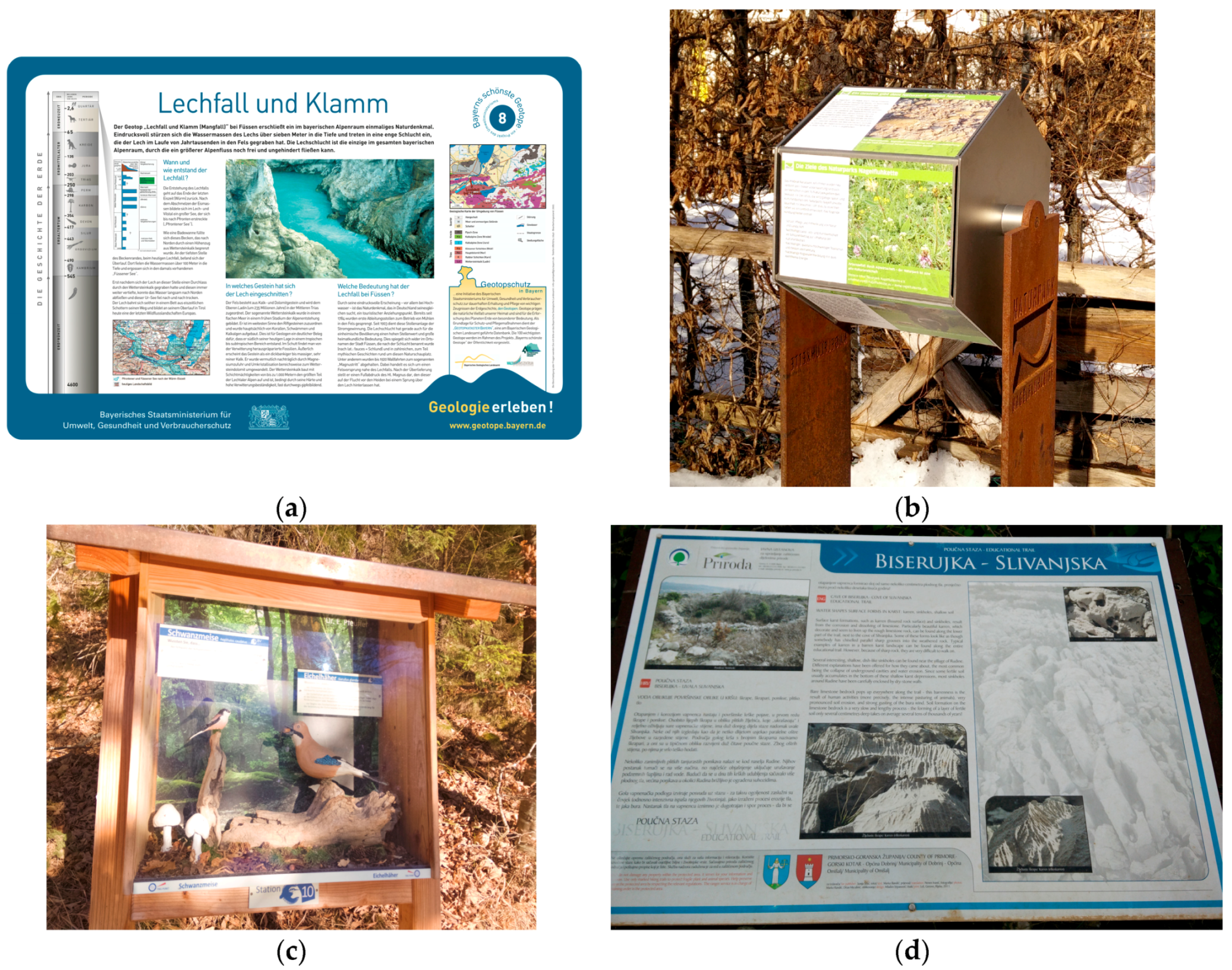
Figure 3.
In the conceptual typology, latent geotourists populate the left and archetypal geotourists the right. Characteristics, desires, and presumed impact were factors gleaned from the literature. Personifications were merely added to the graphic for convenience.
Figure 3.
In the conceptual typology, latent geotourists populate the left and archetypal geotourists the right. Characteristics, desires, and presumed impact were factors gleaned from the literature. Personifications were merely added to the graphic for convenience.

Figure 4.
Interpretive strata overlay the typology to indicate what tools different types of geotourists would theoretically like to find related to geosites. The top or surface layer (1) is interpretation while the deepest or bottom layer (3) is strictly information.
Figure 4.
Interpretive strata overlay the typology to indicate what tools different types of geotourists would theoretically like to find related to geosites. The top or surface layer (1) is interpretation while the deepest or bottom layer (3) is strictly information.

Figure 5.
Site of the earthquake and subsequent landslide at Mount Dobratsch as seen from a viewing platform above. The Gail Valley lies below. Photo: Sonja Prendivoj.
Figure 5.
Site of the earthquake and subsequent landslide at Mount Dobratsch as seen from a viewing platform above. The Gail Valley lies below. Photo: Sonja Prendivoj.
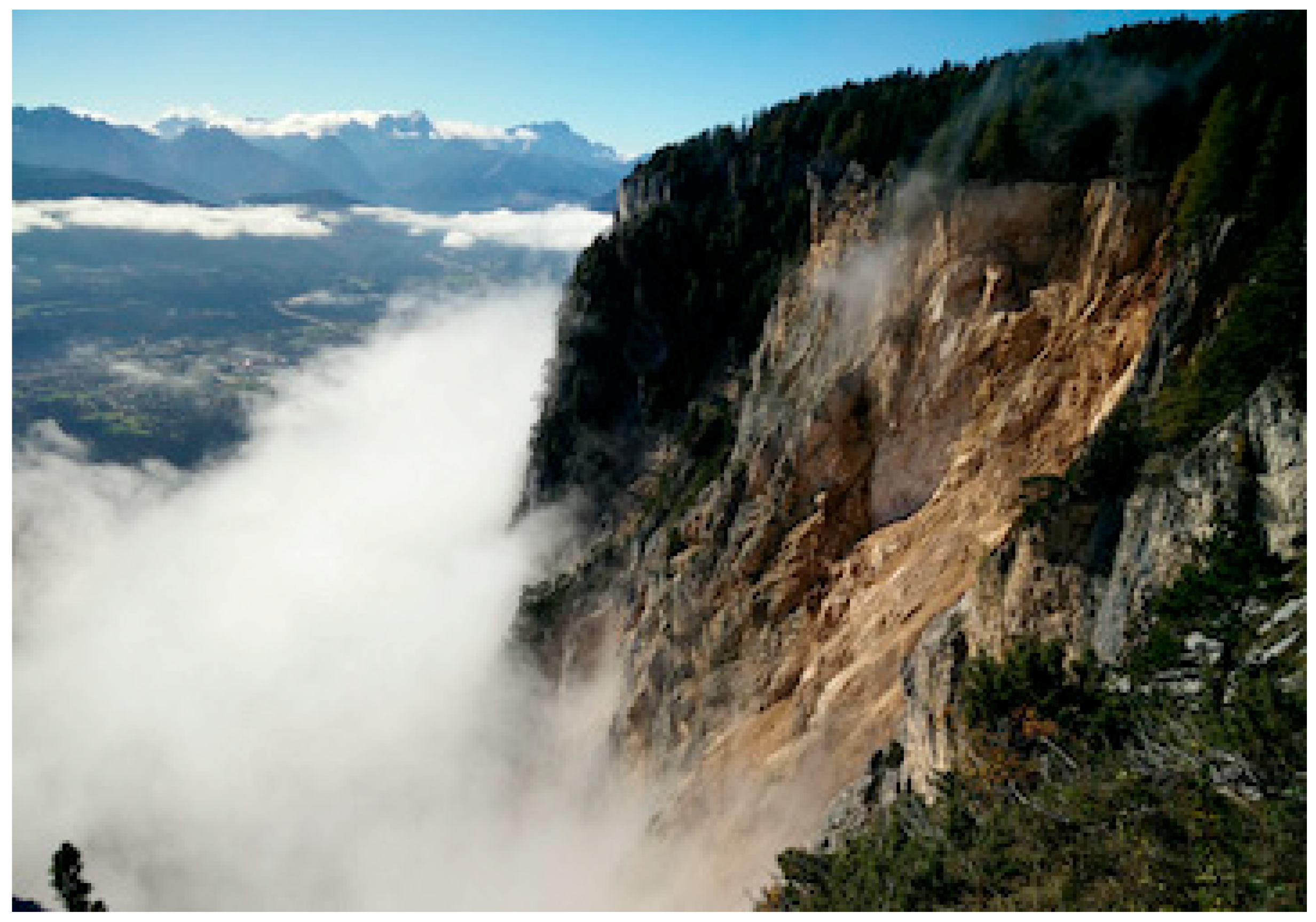
Figure 6.
A mock-up of the sign template. Latin was used for the body since interpretive text is outside of the scope of this paper. The title was written to introduce the topic of deep time to the latent geotourist in a dramatic fashion for a strong first impression [65]. It refers to slope movements, which measured up to one meter a year in parts of the Reppwand-Oselitzenbach sagging zone [2]. The reason the photo is opaque is to solve the problem of sign placement sometimes encountered by the visitor who does not know where to look [46]. It directs the eye but makes the landscape itself the focus, not the photo. The format employs chunking so it does not overwhelm the viewer with text even when several signs are displayed on site. One could be printed for each of the ABCs, allowing one to follow the blended approach some markets demand. The finished sign is meant to be double sided to accommodate international venues with bilingual signs. The size of the sign follows ISO standard A1 or A2 (594 × 841 mm or 420 × 594 mm, respectively). A brochure is attached or available nearby. The author used her working name for the sign concept, ‘geo-portal,’ as a placeholder for the website link in the graphic.

Figure 7.
This is a second rough sketch of the template in progress. The existing brochure from the Bavaria’s Most Beautiful Geosites series (see Figure 2a) can be employed. Again, the image in the photo guides the eye and does not need to be fully visible. The waterfall opposite the gorge could be served by a second sign to describe historic tales, biological anomalies, or other engaging information. Their relatively small size means several can be installed without causing the Schilderwald effect.
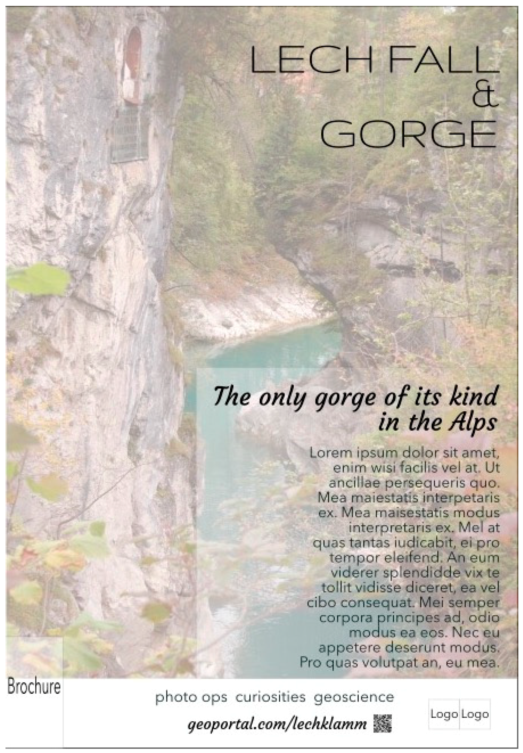
Table 1.
Primary practical factors involved in sign development.
| Factor | Considerations | Related Research |
|---|---|---|
| Mechanics | Number of words Number of topics Type of content (i.e., technical, thematic) Visual communication (i.e., graphic design) Attracting, holding power Display/installation | Rodriguez Estrada and Davis [28]; Wandersee and Clary [45] Bitgood et al. [46]; Thompson and Bitgood [47]; Megerle [48] |
| Interpretive writing | Text composition | Tilden [36]; Megerle [48]; Ham [49]; Beck and Cable [50]; Skibins [51] |
| Outcomes | Learning (teaching, raising awareness) Behavioral (guiding actions) Emotional (creating meaning) | Barrow [29]; Megerle [48]; Skibins [51]; Falk et al. [52,53] |
Table 2.
Conceptual geotourist categories.
| Latent Geotourists | Archetypal Geotourists |
|---|---|
| Geotourist lite | Social geotourist |
| Mass geotourist | Classic geotourist |
© 2018 by the author. Licensee MDPI, Basel, Switzerland. This article is an open access article distributed under the terms and conditions of the Creative Commons Attribution (CC BY) license (http://creativecommons.org/licenses/by/4.0/).
Share and Cite
MDPI and ACS Style
Prendivoj, S.M. Tailoring Signs to Engage Two Distinct Types of Geotourists to Geological Sites. Geosciences 2018, 8, 329. https://doi.org/10.3390/geosciences8090329
AMA Style
Prendivoj SM. Tailoring Signs to Engage Two Distinct Types of Geotourists to Geological Sites. Geosciences. 2018; 8(9):329. https://doi.org/10.3390/geosciences8090329
Chicago/Turabian StylePrendivoj, Sonja M. 2018. "Tailoring Signs to Engage Two Distinct Types of Geotourists to Geological Sites" Geosciences 8, no. 9: 329. https://doi.org/10.3390/geosciences8090329
Note that from the first issue of 2016, this journal uses article numbers instead of page numbers. See further details here.