Article

Interpretation of the Factors Defining Groundwater Quality of the Site Subjected to the Wildfire of 2007 in Ilia Prefecture, South-Western Greece

by
Stavroula Dimitriadou
*,
Konstantina Katsanou
,
Stavros Charalabopoulos
and
Nikolaos Lambrakis
Laboratory of Hydrogeology, Department of Geology, University of Patras, 26504 Rio-Patras, Greece
*
Author to whom correspondence should be addressed.
Geosciences 2018, 8(4), 108; https://doi.org/10.3390/geosciences8040108
Submission received: 18 February 2018 / Revised: 17 March 2018 / Accepted: 19 March 2018 / Published: 23 March 2018

Abstract

:
The present study examines the factors that define groundwater quality of a site subjected to the wildfire of 2007 in Ilia Prefecture, Peloponnese. This wildfire was the most severe in Greece in the last decade. An extensive sampling was carried out three months after the fire. Ninety-nine samples were analyzed in the Hydrogeology Laboratory of University of Patras for major and trace elements. The groundwater samples were classified into three hydrochemical types: Ca-HCO3, Ca-HCO3-SO4 and Ca-Na-HCO3. The hydrochemical results, processed using R-type factor analysis, resulted in a three-factor model that did not indicate any wildfire impact. The values of pH and electrical conductivity ranged between the expected levels for the area. The most abundant cations (Ca, Mg, Na, K) and trace elements (Mn, Zn, Cu, Cd, Pb, V) in the ash, occurred in the majority of the groundwater samples at concentrations below the potable limits set by the European Council. The concentrations of NO3, NO2, NH4+, phosphates, and sulphates, where present, were attributed to agricultural land uses of the area. No hydrochemical disturbances were found that could indicate a fire-retardant effect. It is likely that the prominent thickness of the unsaturated zone, of the granular aquifers that prevail in the area, limited the infiltration of the elements and trace elements usually found in abundance in fire ash.

1. Introduction

Wildfires are common in Mediterranean areas during summer time. For many researchers, their severity over the last decade was linked to Climate Change, which lead to soil erosion and a decrease in biodiversity [1]. The most severe wildfire of the last decade, in Greece, occurred in Ilia Prefecture, Southwestern Greece, during 24–28 August 2007. The biggest part of the burnt site consisted of pine forest (Pinus halepensis). There have been several publications over the current decade that report on the impacts of the produced ash on soil and soil water, mentioning the need for the potential impacts on groundwater to be also examined. According to several laboratory-conducted studies that simulated the combustion of biomass, such as P. halepensis, ash is alkaline (pH = 9–13.5), rich in elements, such as Ca, Mg, Na, K, Al, Fe and P, S and trace elements, such as Mn and Zn [2,3,4]. The most prevailing elements after the wildfires were reported to be Ca, Mg, K, Si, P [5], Mn, Zn, V, Pb, Cr, and Cu [6]. The ash is transported by runoff and wind to surface waters, while a part of it, after being wet, penetrates the soil, filling up the water of aquifers; thus, affecting the soil profile and deteriorating the quality of the water supplies.
More specifically, infiltrating water elutes cations to the soil, thus altering concentrations of nutrients and pH values of the soil profile. Elevated pH values affect the availability of nutrients. A medium to high temperature of combustion values leads to intense effects in chemistry and runoff. The values of pH increase and there is a release of cations (K, Na, Ca, and Mg) from the ash. The ash produced at high temperatures of combustion is hydrophilic, facilitating infiltration. For temperatures of combustion higher than 450 °C, as in most Greek forest fires, ash is characterized by high concentrations of metals [5]. Metals are of major importance due to their high toxicity, their long life and their tendency to bioaccumulate in aquatic systems [6]. The severity of wildfires affects the type and amount of eluted elements, while the Sodium Adsorption Ratio (SAR) is higher for intense wildfires [4]. Moreover, in Mediterranean areas, as the new hydrological year begins, rainfalls are usual during the months following the period of wildfires. Rainfalls activate the transportation of ash to nearby sites by increasing the runoff [6].
According to Pereira et al. [4], Ca, S, Mg, K, and Na prevailed in soil water at an affected P. pinaster forest in Portugal. Kučerová et al. [7] found high concentrations of P, N in a Pinus rotundata forest in the Czech Republic, three years after the fire. They also reported concentrations of Soluble Reactive Phosphorus (SRP) of the same level between a newly burnt site and a site burnt seven years earlier [7].
According to Earl and Blinn [8], high concentrations of NH4, N, SRP, and K, and increased alkalinity values, lasted for thirteen months at an affected area of P. halepensis forest in the Southwestern USA, both in nearby streams and in streams far away from the affected area.
Tobin et al. [9], in California, USA, found high concentrations of dissolved N that have been gradually decreasing to average values, 3–4 years after the fire. Nagra et al. [10], in a limestone cave in Yanchep National Park, in Southwestern Australia, with a climate similar to that of the Mediterranean, attributed the movement of ions and high concentrations of SO4 and K to fire ash.
In addition, there are a number of laboratory studies mentioning the significant role of long-term fire retardants, used by the Hellenic Fire Service, and their potential impact on groundwater quality. These studies underlined the need for potential impacts to be examined under field conditions [11,12,13]. Long-term fire retardants are the same chemical compounds, nitrogen, phosphorus, and sulfur, found in agricultural fertilizers [2,3]. Laboratory treatments of P. halepensis needles have proven the leaching of ammonium ions and phosphates and the elution of Fe, Cu, Zn, and Mn into soil water, which could end up in groundwater [11].
The present study aims to investigate the effects of the aforementioned wildfires on groundwater in Ilia, thus filling this gap in the literature. This study examines and interprets the factors that define groundwater quality of a site subjected to wildfire, identifies the hydrochemical types of groundwater, and evaluates the potential wildfire effect on the groundwater of the area, based on the results of major elements and trace element analyses, which were carried out three months after the wildfire.

2. Study Area

2.1. Climate and Geology

Ilia Prefecture is an agricultural area with a low altitude, in Western Peloponnese, which borders the Ionian Sea. The prefecture occupies an area of 2681 km2 with 183,521 residents [14]. The climate of the area is Mediterranean mild (average air temperature is 17 °C, average annual precipitation is 921 mm, average wind intensity is 4.7 kn NW, and average humidity is 69%) [15]. Lithology, climate, and tectonic activity define the relief formation. The bedrock of the area consists of the formations of three geotectonic zones of the External Hellenides, as shown in Figure 1 (west to east): The Ionian zone, Gavrovo-Tripolis zone, and Olonos-Pindos zone. The neotectonic structure of the area is characterized by the presence of tectonic grabens and horsts, trending E–W and NNW–SSE [16]; examples include Illida graben and Stafylia graben [17,18,19].
The aquifer systems of the area can be classified into two main categories. The first category consists of karst aquifer systems (E–SW and NW–SE), which occupy 20% of the affected area. They belong to the limestones of the Olonos-Pindos and Gavrovo-Tripolis zones. They include considerable aquifers, mostly developed in Cretaceous limestones (Figure 1). Tectonic activity and karstification of the limestones resulted in the formation of these aquifers. The second category consists of granular aquifer systems of Neogene and Quaternary. Granular aquifer systems occupy 80% of the study area (Figure 1). They were formed inside alluvial deposits where the superposition of confined aquifers occurs. Unconfined aquifers have often been developed in Quaternary deposits, where groundwater flows to the direction of the sea. The principal aquifers of the granular formations are found in depths between 50–100 m or greater [24,25]. The Alpheios and Pineios are the main rivers of the area.

2.2. Reported Impacts of the Wildfire

The study area is the largest area of Ilia Prefecture which has been subjected to the most severe wildfire of the last decades in Greece. The wildfire caused the burning of protected areas: 2994 ha (30%) of Foloi oak forest, 757 ha (22.5%) of Strofilia pinus forest, 67 ha (21%) of Olympia forest. It also caused habitat loss, urban damage, and human losses (25 deaths) [26]. The wildfire threatened ancient sites, such as the ancient Stadium in Olympia, where the Olympic Games took place in ancient times. The aforementioned sites are highly protected by national, international and European Commission conventions (Ramsar: 3GR011, Natura 2000—SCI, SAC: GR2320001, GR2320011, GR2330004, GR2330006, GR2330007, GR2330008, Natura 2000—SPA: GR2330009, GR2320012) [27,28].

3. Materials and Methods
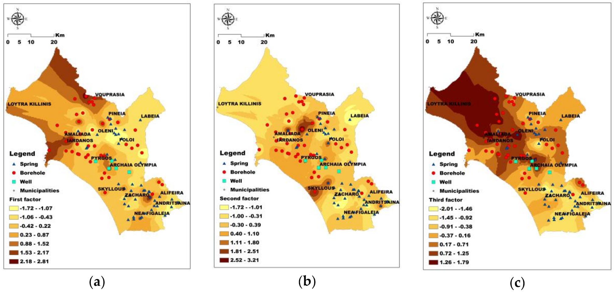
Three months after the wildfire, in November 2007, 99 samples were collected from springs, boreholes, wells of the granular aquifers, and from springs of karst aquifers (Figure 1), in accordance with the United States Environmental Protection Agency’s rules [29]. Major element and trace element analyses were processed immediately after the sampling in the Hydrogeology Laboratory at the Geology Department at the University of Patras (error lies within the accepted range of ±5%). The unstable physical and chemical parameters (water temperature (Tw), electrical conductivity (E.C.), pH, dissolved oxygen (D.O.), redox potential (Eh)) were measured, in situ, using a portable Consort C533 (Consort bvba, Yunhout, Belgium). The concentration of H2S was measured in the field using a Hach DR 2400 portable spectrometer (Hach, Loveland, CO, USA), while CO2 and alkalinity were measured using a Hach Digital Titrator. NO3, NO2, PO43−, SO42−, F, SiO2 and NH4+ concentrations were determined using a Hach DR 4000 spectrometer. The concentration of Cl was measured using a Hach Digital Titrator. An Avanta P (GBC Scientific Equipment, Dandenong, Australia) was used to determine the cation’s concentrations. Concentrations of trace elements were determined using an ELAN 6100 Inductively Coupled Plasma-Mass Spectrometer (ICP-MS) (Perkin-Elmer, Waltham, MA, USA). Phreeqc 3.0 (USGS, Reston VA, USA) was used to determine the hydrochemical types of groundwater in the study area. In order to interpret the results of the physicochemical analyses regarding groundwater quality after the wildfire, a multicomponent statistical analysis was carried out. Exploratory factor analysis was processed in SPSS 24 (IBM, Armonk, NY, USA) (Principal Component Analysis with Varimax rotation method), based on the eigenvalues criterion (eigenvalues > 1). This method is considered suitable for hydrogeological environments by several researchers and has been used in the literature for Peloponnese groundwater analysis, where our study area is also located [30,31]. Sampling adequacy was measured according to the Kaiser-Meyer-Olkin measure (0.70). In order to secure the normality of our tested data, log-transformation (the decimal logarithms of the parameters) was used for the parameters that did not initially follow the normal distribution. Spatial distribution maps of the three factors, with the concentrations of NO3, NO2, NH4+ and E.C., were created in GIS, ArcMap 10.5 (ESRI, Redlands, CA, USA). Since the study area is vast (the entire Ilia Prefecture is almost 2681 km2), and the sampling points were below 100 (i.e., 99), the Inverse Distance Weighting Interpolation method (IDW) was preferred over Ordinary Kriging. This is also because, although the distribution maps were practically the same, there was no conflict in the literature on the minimum number of the interpolated points, which is a prerequisite to apply IDW.

4. Results

The groundwater samples were classified into three hydrochemical types. The prevailing type was Ca-HCO3, which is typical of fresh water with an efficient recharge. The dilution of gypsum, which is abundant in the Neogene formations of the area, leads to samples of a Ca-HCO3-SO4 water type (Figure 1). The relatively-elevated Na concentrations in the Ca-Na-HCO3 type is mostly attributed to ion-exchange processes, the presence of evaporates, and, in some cases, to seawater intrusion. Nevertheless, in most cases, the aforementioned concentrations were below the permissible limits for drinking-water, according to the 98/83/EC Directive of the European Council (or according to the World Health Organization for limits that are not set by the former directive) (Table 1 and Table 2) [32,33].
After subsequent analysis, the concentrations of the major and trace elements in groundwater did not express any tendency that could be attributed to the wildfire. Wildfire ash alters the pH of both surface water and soil. A significant amount of metals and trace elements are released from the ash, emerging in surface water, soil water and groundwater. Long-term fire retardants used in wildfires are the chemical compounds of nitrogen, phosphorus, and sulfur, which could end up in groundwater. However, the average pH value after the fire was 7.1 and the maximum pH value was 8.1. Moreover the post-fire values of E.C., a parameter that indicates the increase of cations, if any, were similar or lower to those before the wildfire compared to the values of the respective parameters reported by the Institute of Geological and Mineralogical Exploration of Greece (IGME) in 2004–2005 (Table 3). In addition, no other large-scale fire event has been reported between 2004–2005 and 2007 [34,35]. The former deduction was also verified by the measured concentrations of cations (Ca, Mg, Na, and K), as shown in Table 1, and the concentrations of trace elements for groundwater (Mn, Fe, Zn, Cu, Cd, Pb, V) as displayed in Table 2. Both main elements’ and trace elements’ concentrations ranged below the potable limits for the majority of the samples [32,33]. The concentrations of nitrogen ions (NO2, NO3, NH4+), phosphates, sulfates, and E.C. were as expected for the area, and no alterations were found that could be attributed to the wildfire (Table 1 and Table 3, Figure 2). However, some inconsistencies in NO3 concentrations were attributed to the fertilizers and the soil amendments regularly used by the farmers. Consequently, elevated values can be randomly found in the measurements [24]. Moreover, the superposition of the aquifers in the study area and the fact that the sampling sites of 2004–2005 and 2007 were spatially close, but not the same (Table 3), account for several minor differentiations [36]. In order to examine any tendency of elevated (in some samples) parameters that could affect groundwater quality as a result of the wildfire, a multicomponent statistical analysis was performed on the respective parameters.
Multicomponent statistical analysis was carried out by applying R-type exploratory factor analysis (Principal Component Analysis with Varimax rotation) in SPSS 24, after initially performing decimal logarithm transformation on the parameters that did not follow the normal distribution. The statistical analysis resulted in a three-factor model that represented 67.34% of the initial-values information (total variance) (Table 4). The loadings of each factor are presented in Table 5.
The first factor accounts for 28.54% of the total variance (Table 4) and underlines the relation between groundwater–temperature (Tw) and the presence of Li and B. In the literature, the presence of these elements, along with higher Tw values, have been deeply associated with deep water circulation through tectonic structures, and a longer residence time. The area where the maximum scores of the first factor occur, belongs to Stafylia graben, where deep fault zones are found [17,18,19]. The aforementioned relationship accounts for the increased (maximum) value of B measured in the same area, shown in Table 1. Additionally, a proportion of the initial statistical information of the first factor is accounted to Fe and Mn, which abound in the aquifers of Amaliada and Vouprasia because of the reductive environment (slightly acidic groundwater) of the area (Figure 3a) which is verified by the corresponding pH values of Amaliada and Vouprasia, shown in Table 3 [36]. This reductive environment is more obvious by the distribution of the scores of the third factor (Figure 3c). The second factor accounts for 22.16% of the total variance (Table 4) and relates the slightly elevated concentrations of Cr, U and As, to the redox conditions (Figure 3b). The third factor accounts for 16.63% of the total variance (Table 4) and more thoroughly displays the redox conditions of the area, depicting the relation between negative values of redox potential (Eh) and Mn in reductive groundwater environments (Figure 3c).

5. Discussion and Conclusions

Vulnerability of aquifers to pollution is a function of the type of the rock, the width of the unsaturated zone, the climate of the area and the composition of the pollutants. Burnt biomass affects the composition of ash. Ash and long-term fire retardants facilitate the accumulation of major elements and trace elements, and of nitrogen, phosphorus, and sulfur compounds, respectively. In the current case study of the burnt area in Ilia, the unsaturated zone is protected by impermeable rocks. Moreover, the average annual precipitation, which is over 900 mm, allows the dissolution and transportation of pollutants through surface water and groundwater. On the contrary, karst aquifers at higher altitudes, where limestones prevail and the coastal aquifers are next to the Strofilia forest, are vulnerable to pollution. However, precipitation at higher altitudes is greater than the aforementioned average. The sampling process was carried out in November 2007, when the dry period had already finished and a number of heavy rainfalls had already occurred. Therefore, the maximum alterations in groundwater quality would have already occurred. However, chemical analyses resulted in an expected amount of concentrations of major elements and trace elements for the area. The physicochemical parameters confirmed a trivial picture for Ilia: Increased salinity of the granular aquifers’ water, compared to that of karst aquifers’, and the presence of Fe and Mn in slightly acidic water, which factor analysis also showed. The concentrations and peaks of nitrogen compounds in the area signify agricultural and livestock land-uses, where fertilizers and soil amendments are applied on a seasonal basis. After comparing the measured values of parameters, such as pH, E.C., and concentrations of NO2, NO3, and NH4+, before and after the wildfire of 2007, no deteriorations were detected that could be related to the use of long-term fire retardants. Phosphate leaching, which could correspond to long-term fire retardants, was not detected in groundwater as expected by the laboratory research of Pappa et al. [12]. The results are attributed to the noteworthy depth of the unsaturated zone of the granular formations that prevail in the affected area, and to the dilution that takes place along the Pineios and Alpheios rivers.
Multicomponent statistical analysis (R-type factor analysis) pointed out the relationship between Li and B, along with elevated water temperature values in an area where fault zones occur, a finding that will be further investigated in future studies

Acknowledgments

The authors would like to thank Ilia Prefecture for having funded a project that led to this study, George Siavalas for his contribution to that project and associate professor Konstantinos Nikolakopoulos for his assistance in the geostatistical analysis.

Author Contributions

The present study is a part of Stavroula’s Dimitriadou M.Sc. research. Stavroula Dimitriadou wrote the paper, carried out the statistical and geostatistical analyses, created the interpolation maps and the tables, and made the interpretation of the results. Konstantina Katsanou carried out the sampling process and the chemical analyses and constructed the geological map of the area. Stavros Charalabopoulos participated in the sampling process. Nikolaos Lambrakis coordinated the overall research and participated in the interpretation of the results.

Conflicts of Interest

The authors declare no conflicts of interest.

References

  1. Olivella, M.A.; Ribalta, T.G.; De Febrer, A.R.; Mollet, J.M.; De Las Heras, F.X.C. Distribution of polycyclic aromatic hydrocarbons in riverine waters after Mediterranean forest fires. Sci. Total Environ. 2014, 355, 156–166. [Google Scholar] [CrossRef] [PubMed]
  2. Kalabokidis, K.D. Effects of wildfire suppression chemicals on people and the environment—A review. Glob. Nest Int. J. 2000, 2, 129–137. [Google Scholar]
  3. Liodakis, S.; Tsoukala, M. Ash leaching of forest species treated with phosphate fire retardants. Water Air Soil Pollut. 2009, 199, 171–182. [Google Scholar] [CrossRef]
  4. Pereira, P.; Úbeda, X.; Martin, D.; Mataix-Solera, J.; Cerdà, A.; Burguet, M. Wildfire effects on extractable elements in ash from a Pinus pinaster forest in Portugal. Hydrol. Process. 2014, 28, 3681–3690. [Google Scholar] [CrossRef]
  5. Bodí, M.B.; Martin, D.A.; Balfour, V.N.; Santín, C.; Doerr, S.H.; Pereira, P.; Cerdà, A.; Mataix-Solera, J. Wildland fire ash: Production, composition and eco-hydro-geomorphic effects. Earth Sci. Rev. 2014, 130, 103–127. [Google Scholar] [CrossRef]
  6. Silva, V.; Pereira, J.L.; Campos, I.; Keizer, J.J.; Gonçalves, F.; Abrantes, N. Toxicity assessment of aqueous extracts of ash from forest fires. Catena 2015, 135, 401–408. [Google Scholar] [CrossRef]
  7. Kučerová, A.; Rektoris, L.; Štechová, T.; Bastl, M. Disturbances on a wooded raised bog—How windthrow, bark beetle and fire affect vegetation and soil water quality? Folia Geobot. 2008, 43, 49–67. [Google Scholar] [CrossRef]
  8. Earl, S.R.; Blinn, D.W. Effects of wildfire ash on water chemistry and biota in south-western USA streams. Freshw. Biol. 2003, 48, 1015–1030. [Google Scholar] [CrossRef]
  9. Tobin, B.W.; Schwartz, B.F.; Kelly, M.; Despain, J.D. Fire retardant and post-fire nutrient mobility in a mountain surface water—Karst groundwater system: The Hidden Fire, Sequoia National Park, California, USA. Environ. Earth Sci. 2014, 73, 951–960. [Google Scholar] [CrossRef]
  10. Nagra, G.; Treble, P.C.; Andersen, M.S.; Fairchild, I.J.; Coleborn, K.; Baker, A. A post-wildfire response in cave dripwater chemistry. Hydrol. Earth Syst. Sci. 2016, 20, 2745–2758. [Google Scholar] [CrossRef]
  11. Liodakis, S.; Katsigiannis, G.; Kakali, G. Ash properties of some dominant Greek forest species. Thermochim. Acta 2005, 437, 158–167. [Google Scholar] [CrossRef]
  12. Pappa, A.; Tzamtzis, N.; Koufopoulou, S. Effect of fire retardant application on phosphorus leaching from Mediterranean forest soil: Short-term laboratory-scale study. Int. J. Wildland Fire 2006, 15, 287–292. [Google Scholar] [CrossRef]
  13. Koufopoulou, S.; Michalopoulos, C.; Tzamtzis, N.; Pappa, A. Impact of a long term fire retardant (fire trol 931) on the leaching of Na, Al, Fe, Mn, Cu and Si from a mediterranean forest soil: A short-term, lab-scale study. Bull. Environ. Contam. Toxicol. 2014, 92, 708–713. [Google Scholar] [CrossRef] [PubMed]
  14. Hellenic Statistical Authority. Available online: http://www.statistics.gr/el/statistics/-/publication/SAM03/2011 (accessed on 22 December 2017).
  15. Hellenic National Meteorological Service. Climatic Atlas of Greece. Available online: http://climatlas.hnms.gr/sdi/?lang=EN (accessed on 22 December 2017).
  16. Fountoulis, I. Neotectonic Evolution of Western-Central Peloponnese. Ph.D. Thesis, University of Athens, Athens, Greece, 7 November 1994. [Google Scholar]
  17. Stamatopoulos, L.; Kontopoulos, N. Geomorphology and evolution of the region between Lapa and Eleotopos, northwestern Peloponnesus (Greece). IL Quaternario Ital. J. Quat. Sci. 1994, 7, 537–544. [Google Scholar]
  18. Koukouvelas, I.; Mpresiakas, A.; Sokos, E.; Doutsos, T. The tectonic setting and earthquake ground hazards of the 1993 Pyrgos earthquake, Peloponnese, Greece. J. Geol. Soc. 1996, 153, 39–49. [Google Scholar] [CrossRef]
  19. Papanikolaou, D.; Fountoulis, I.; Metaxas, Ch. Active faults, deformation rates and Quaternary paleogeography at Kyparissiakos Gulf (SW Greece) deduced from onshore and offshore data. Quat. Int. 2007, 171–172, 14–30. [Google Scholar] [CrossRef]
  20. Institute of Geological and Mineralogical Exploration. Program of Compiling the Geological Map of Greece in Scale 1:50000. Amalias Sheet; IGME: Athens, Greece, 1981. [Google Scholar]
  21. Institute of Geological and Mineralogical Exploration. Program of Compiling the Geological Map of Greece in Scale 1:50000. Kato Fighalia Sheet; IGME: Athens, Greece, 1973. [Google Scholar]
  22. Institute of Geological and Mineralogical Exploration. Program of Compiling the Geological Map of Greece in Scale 1:50000. Olympia Sheet; IGME: Athens, Greece, 1981. [Google Scholar]
  23. Institute of Geological and Mineralogical Exploration. Program of Compiling the Geological Map of Greece in Scale 1:50000. Pirgos Sheet; IGME: Athens, Greece, 1980. [Google Scholar]
  24. Karapanos, E. Hydrogeological-Hydrochemical Parameters of the Drained Mouria Lake (Prefecture of Ilia), Controlling the Rehabilitation and the Sustainable Management of the Wetlands. Ph.D. Thesis, University of Patras, Patras, Greece, 22 September 2009. [Google Scholar]
  25. Karapanos, E.; Katsanou, K.; Karli, A.; Lambrakis, N. Evaluation of the geochemical conditions in the deep aquifer system in Vounargo area (SW Greece) based on hydrochemical data. In Advances in the Research of Aquatic Environment; Lambrakis, N., Stournaras, G., Katsanou, K., Eds.; Springer: Berlin, Germany, 2011; Volume 2, pp. 201–210. [Google Scholar]
  26. WWF Greece. Fire Report Peloponnisos. Available online: https://www.wwf.gr/storage/additional/FIRE_report_Peloponnisos (accessed on 23 December 2017).
  27. Copernicus Land Monitoring Service. Available online: http://land.copernicus.eu/pan-european/corine-land-cover/clc-2006/view (accessed on 23 December 2017).
  28. Natura 2000 Network Viewer. Available online: http://natura2000.eea.europa.eu (accessed on 23 December 2017).
  29. United States Environmental Protection Agency. Quick Guide to Drinking Water Sample Collection. Available online: https://www.epa.gov/sites/production/files/2015-11/documents/drinking_water_sample_collection.pdf (accessed on 23 December 2017).
  30. Lambrakis, N.; Antonakos, A.; Panagopoulos, G. The use of multicomponent statistical analysis in hydrogeological environmental researc. Water Res. 2004, 38, 1862–1872. [Google Scholar] [CrossRef] [PubMed]
  31. Voudouris, K.; Lambrakis, N.; Papatheothorou, G.; Daskalaki, P. An application of factor analysis for the study of the hydrogeological conditions in Plio-Pleistocene aquifers of NW Achaia (NW Peloponnesus, Greece). Math. Geol. 1997, 29, 43–59. [Google Scholar] [CrossRef]
  32. European Commission. Council Directive 98/83/EC of 3 November 1998 on the Quality of Water Intended for Human Consumption; European Commission: Brussels, Belgium, 1998; pp. 32–54. [Google Scholar]
  33. World Health Organization. Guidelines for Drinking Water Quality, Fourth Edition Incorporating the First Addendum. Available online: http://apps.who.int/iris/bitstream/10665/254637/1/9789241549950-eng.pdf (accessed on 23 December 2017).
  34. Institute of Geological and Mineralogical Exploration. Record and Assessment of the Hydrogeological Characteristics of Groundwater and Aquifer Systems of the Country (K.E. 7.3.2.1.). Available online: http://www.igme.gr/index.php/proionta-ypiresies (accessed on 23 December 2017). (In Greek).
  35. Tsagari, K.; Karetsos, G.; Proutsos, N. Forest Fires in Greece, 1983–2008, 1st ed.; WWF Greece and Ethiage: Athens, Greece, 2011; pp. 1–104. ISBN 978-960-88241-3-3. (In Greek) [Google Scholar]
  36. Dimitriadou, S.; Katsanou, K.; Charalambopoulos, S.; Lambrakis, N. Impacts of wildfires on groundwater quality. A case study of Elia Prefecture in 2007. In Proceedings of the 11th International Hydrogeological Congress of Greece, Athens, Greece, 4 October 2017; Stamatis, G., Voudouris, K., Vasileiou, E., Psomiadis, D., Diakakis, M., Potamianou, M., Grigoriou, I., Athanasiadou, L., Eds.; Hellenic Chapter of IAH and Cyprus Association of Geologists & Mining Engineers: Athens, Greece, 2017; pp. 113–124. [Google Scholar]
Figure 1. Geological map and sampling sites of the study area [20,21,22,23].
Geosciences 08 00108 g001
Figure 2. Distribution maps (a) NO2; (b) NO3; (c) NH4+; and (d) Electrical Conductivity (E.C.).
Geosciences 08 00108 g002
Figure 3. Distribution maps of the three factors’ scores: (a) 1st factor: B, Li, water temperature (Tw), Ba, Fe and Mn; (b) 2nd factor: Cr, As, and U; and (c) 3rd factor: redox potential (Eh) and Mn.
Geosciences 08 00108 g003
Table 1. Descriptive statistics of selected major elements and main physicochemical parameters of groundwater after the wildfire.
MinpHEhTwE.C.NH4+NO3NO2SO42−PO43−ClKNa+Mg2+Ca2+
6.1−65.09.4214.00.00.00.00.00.07.00.31.41.121.0
Max8.1231.019.81220.07.132.00.1262.00.7201.0512.5230.750.2162.0
Avg7.183.814.4473.30.25.10.047.40.120.619.720.38.9100.5
St.D.0.3269.772.26175.421.04.170.0154.500.0722.2152.4027.897.1026.57
Limit---25000.550.00.5250.0-250.0-200--
Min, Max, Avg, St.D. stand for minimum, maximum, average and standard deviation, respectively. Values of major elements/ions are in mg/L, values of redox potential (Eh) are in mV, values of water temperature (Tw) are in °C, values of electrical conductivity (E.C.) are in μS/cm. 3 Limits of concentrations set by 98/83/EC Directive [33], -: No specific limit set.
Table 2. Descriptive statistics of selected trace elements in groundwater after the wildfire.
MinAsBCrCuUPbLiMnFeZn
0.094.610.001.210.000.550.460.000.000.27
Max7.06333.4041.455.614.6847.6126.49319.39881.6551.25
Avg0.6337.276.180.100.765.115.4916.8650.8014.32
St.D.0.7942.017.421.010.945.904.5945.72130.1413.92
Limit101000502000 *30 *10-50200-
Min, Max, Avg, St.D. stand for minimum, maximum, average and standard deviation respectively. Values of trace elements are in μg/L. Limits of concentrations set by 98/83/EC Directive [32], * limits set by the WHO [33]; -: No specific limit set.
Table 3. Comparison of parameters before and after the wildfire, between selected samples, per area [36].
pHE.C.HCO3NO3PO4SO4ClKNaMgCaFeMn
Alifeira 058.2--6.20-26.9049.62.30243.704.5010.30--
Alifeira 077.3319.00226.926.000.1110.808.600.648.504.6122.5023.040.25
Amaliada 057.4646.00273.9831.00-86.4517.700.7813.799.73109.82--
Amaliada 076.9553.00306.2210.000.07178.0019.101.3220.2810.58107.0050.6123.95
Andritsaina 057.5-384.0043.40-124.0069.100.8050.6036.90119.007.50-
Andritsaina 077.9345.00231.8012.000.1143.807.803.256.842.2595.500.000.00
A.Olympia 057.8-384.4031.00-167.50125.901.7074.1051.10118.60--
A.Olympia 077.2470.00284.268.000.122.609.100.558.402.4298.5022.650.20
Vouprasia 05-------------
Vouprasia 076.8428.00334.283.000.1032.4015.001.4937.1110.5880.0039.351.69
Zacharo 057.2374.85281.294.50-12.5215.200.9911.934.9597.57--
Zacharo 076.9411.00325.749.000.074.8010.000.719.713.22105.000.000.19
Iardanos 047.8-360.009.30-63.90227.005.50131.0054.5067.30--
Iardanos 078.0782.00491.663.000.74152.5087.206.52130.7016.7041.00145.1320.31
N.Figaleia 057.3-326.5024.80-142.5088.600.9079.2033.1094.60--
N.Figaleia 077.0450.00340.3815.000.06117.8089.201.0866.6925.21102.5028.910.59
Pineia 057.7-292.906.20-99.4274.463.1337.0018.00113.83--
Pineia 076.9465.00381.8612.000.0880.3041.000.6140.073.28133.5019.640.39
Pyrgos 057.3766.60345.003.10-74.0021.302.3018.4039.8074.70--
Pyrgos 077.0583.00279.3813.200.0970.0051.601.6725.329.5084.5025.080.60
Skyllous 047.51498.00391.0024.80-187.00128.02.3013.8073.00152.00--
Skyllous 077.01220.00346.4810.000.0792.5025.102.4428.5415.50132.500.000.00
Oleni 057.6267.00157.000.00-6.005.300.702.303.1051.30--
Oleni 077.0373.00223.262.100.0832.7021.501.7011.994.2353.5038.971.41
04, 05, 07 stand for the years 2004, 2005, 2007, respectively. Values of major elements/ions are in mg/L, values of trace elements are in μg/L, values of E.C. are in μS/cm.
Table 4. Total variance explained.
ComponentInitial EigenvaluesRotation Sums of Squared Loadings
Total% of VarianceCumulative %Total% of VarianceCumulative %
13.84938.49238.4922.85528.54928.549
21.72317.23055.7222.21722.16850.717
31.16311.62667.3481.66316.63167.348
40.9229.22376.571
50.7757.74984.321
60.5625.62089.941
70.3553.55493.495
80.2892.89496.390
90.2042.03798.426
100.1571.574100.000
Extraction Method: Principal Component Analysis.
Table 5. Factor-loadings as displayed by the Rotated Component Matrix.
Rotated Component Matrix 1
Component
123
Blog0.806
Lilog0.737
Balog0.680
Felog0.680
Tw0.591
Crlog 0.800
Aslog 0.797
Ulog 0.683
Eh −0.873
Mnlog0.550 0.654
1 Extraction Method: Principal Component Analysis. Rotation Method: Varimax with Kaiser Normalization. Blog, Lilog, Balog, Felog, Crlog, Aslog, Ulog, Mnlog stand for the decimal logarithm of each parameter, respectively (displayed loadings with absolute value greater than 0.5).

