1. Introduction
This paper investigates spatial engagements with the landscape through the spiritual-cartographic concept of leylines. The identification and walking of leylines will be discussed as a method of “deep mapping”, a manner in which to “record and represent the grain and patina of place” ([
1], pp. 64–65). Leylines work to uncover and trace occulted trajectories, believed (by some) to form a network of ancient trackways across the landscape, interconnecting with points of both historical and sacred importance. This article aims to highlight the importance of the leyline as a tradition of deep mapping as well as demonstrating the wider significance of the ley in the development of the spatial humanities and indeed, the experimental geographical methods that might be used to engage with leylines.
Leylines make for a rather unfamiliar cartographic system, one that provides a method for navigating one area of the country to another purely by walking along straight lines, indicated by a series of alignments in both naturally occurring and manmade landmarks. In addition to providing a brief history of the leyline, with particular reference to the work of Alfred Watkins, I will develop a critical engagement with leylines, providing an auto-ethnographic response to the walking of a ley. Through a personal account of identifying and walking a ley, the auto-ethnography will be used to illustrate the rich experiential qualities of leylines within the practice of deep mapping.
There has been a substantial interest in occult spatiality in recent years [
2,
3,
4,
5,
6,
7,
8,
9,
10,
11,
12,
13,
14,
15,
16,
17,
18,
19]. Building upon the existing catalogue of research in the area of the spatial and the occult, this research will broaden the foci of the “unpopular geographies” of spectrality and monstrousness to include what I refer to as deeply topological belief systems, bringing original case study material into the scope of
strange affectual landscapes.
In this paper, I will articulate a discourse of place that explicitly deals with the relationality that is expressed through the spatial practice of ley hunting and which allows for both history, memory and narrative to be seen linearly: mobile and navigable. Strictly speaking, then, this is to be a discussion of cartographics, of maps and of mapping, albeit in an arcane fashion. Furthermore this is an enquiry, in the broader sense, into how lines interlope into the realms of archaeology, spirituality and placial ontology. Finally, it considers how lines might indicate particular trajectories that lend themselves to a re-imagining of or re-acquainting with our surroundings.
2. Alfred Watkins: The Ley of the Land
In the September of 1921, 66 year old Alfred Watkins delivered a talk to the Woolhope Naturalist’s Field Club presenting his thesis that the landscape could be mapped as a series of straight lines or “alignment
s” that “connected ancient burial mounds, monuments, barrows, ditches, castles, ponds and trackways” ([
20], p. 81). Watkins went on to name such alignments “leylines”.
Already well published in the fields of photography and local history, Watkins’ long walks across the undulating Herefordshire countryside had generated a huge amount of data, both written and photographic; his work indicated the age and locations of ancient monuments, hill forts, pre-Roman villages, churches, trees, follies and more. Watkins noticed that these objects and their places appeared to be aligned in an unmistakably intentional fashion: long straight trackways appeared to etch their way across the landscape and Watkins attributed the causation of these lines as matching the age of the monuments that marked them: early man. Watkins went on to describe the conception:
Imagine a fairy chain stretched from mountain peak to mountain peak, so far as the eye could reach, and paid out until it touched the high places of the earth at a number of ridges, banks and knowls. Then visualise a mound, circular earthwork, or clump of trees, planted on these high points, and in low points in the valley, other mounds ringed round with water to be seen from a distance. Then great standing stones brought to mark the way at intervals, and on a bank leading up to a mountain ridge or down to a ford the track cut deep so as to form a guiding notch on the skyline as you come up. In a bwlch or mountain pass the road cut deeply to show as a notch afar off. Here and there, and at two ends of the way, a beacon fire used to lay out the track. With ponds dug on the line or streams banked up into “flashes” to form reflecting points on the beacon track so that it might be checked when at least once a year the beacon was fired on the traditional day. All these work exactly on the (ley) line.
According to Watkins what he was describing was not, then, an enchanted genealogy, but rather simply a diagnosis of the facts as they presented themselves to him. And in fact his diagnosis had some precedents: similar conceptions of extensive trackways had previously been recorded, for example by Hilaire Belloc, who had posited and indeed mapped semi-ancient pilgrim paths in his The Old Road [
22]. Belloc displayed a deep sense of connection to trackways, remarking that the road “gives a unity to all that has arisen on its way” ([
22], p. 4). But although Belloc had made early claims for a series of forgotten travel routes, he had limited his scope to the movement of early pilgrims: the idea of an interrelated network of tracks, as later seen in the work of Watkins, had never occurred to him.
It was not the idea of the leyline that formed Watkins greatest challenge. He had derived the concept of the ley from the data that he had accumulated quite easily. Rather, it was formulating the theory into something solid, discovering a way to convey his discovery to a wider audience. He finally achieved this solid explanation in the form of an oral paper delivered to his archaeological peers at the Woolhope Naturalist’s Fieldclub in 1921 [
23]. The first paper was entitled Early British trackways, moats mounds camps and sites. In this initial formulation, Watkins developed his belief that there were a significant number of megaliths and monuments that fell into almost perfectly straight lines within the vicinity of his home county of Herefordshire. He provided hand drawn maps and vast quantities of field research to account for this belief in an intentional linear correlation. The term ley developed as a result of the number of alignments crossing through places whose names ended with “ley” [
21]. Watkins believed there to be a functional reasoning for the existence of these sightlines, their purpose being chiefly to guide the people of early Britain through the landscape. This he posited as being the predominant reason that the alignments had arisen; in the absence of cartography, early communities had required some indicators that they were travelling along the correct route. Watkins’ aim in this early paper was to establish the initial development of “a framework for a new knowledge” ([
23], p. 34), a new method through which to understand the placement of “things” in the landscape.
Unfortunately there is no record of the reception of Watkins’ paper by the Woolhope Club, Shoesmith [
24] notes that the Club did not record any commentary of the presentation in their minutes, though some evidence of Watkins’ continued output with the organisation can be found in later publications of the Club’s proceedings. Whatever the reaction, Watkins set out to publish his findings and produced his first book on the subject in 1922: a publication of the original lecture to the Woolhope in its entirety, complete with accompanying monochrome plates, released a year after he gave his talk. In the foreword to the text, addressed to “the average reader”, Watkins launches a diatribe against his contemporary antiquarians, who he accused of having “alternated between a misty appreciation of hill-tracks and ridgeways, and an implied depreciation of all track makers before the Romans came” ([
23], p. 7). The book was generally well received by the general public, and Watkins is known to have kept a scrapbook of newspaper cuttings documenting the publicity that his ley theory had attracted. He also continued to publish his research in the proceedings of the Woolhope Club [
25].
Keen to have his geometric patterns recognised, Watkins produced his most significant and widely received work, The Old Straight Track in 1925. Where Early British Trackways merely sketched the initial theory, in The Old Straight Track Watkins produced a set of evidence based reports of his walks along these hidden linear routes; this included sketching of ley trajectories, extensive descriptions of the types of indicators of alignments and further photographic verification. Watkins explained his theory in detail over two hundred and twenty six pages, making this book his most substantial and articulated output on the subject of leylines. “The Old Straight Track” [
21] as Watkins termed the leyline, was to be seen across the country and the richly illustrated and meticulous record he had produced presented others with the chance to go out and explore the countryside looking for forgotten ancient pathways by themselves. The positive reception of the second book’s reception became the impetus for Watkins writing a third and final book on the subject of leys. Acting as something of a training guide for fellow ley enthusiasts, The Ley Hunter’s Manual: A Guide to Early Tracks was completed by Watkins in 1927 (mass published in 1977 [
26]), and gave clear instructions on how to identify and uncover leys using maps and also at sight.
For Watkins, leys indicate a forgotten and ancient knowledge, or rather a composite of knowledge; lost, historic and immanent. Watkins insisted that such an understanding was embedded within the landscape, left for us to uncover:
Knowledge is only to be gleaned from three types of evidence. Firstly and chiefly from what exists or is recorded on or in the earth of the work or remains of man of that period. Secondly, from what can be gleaned and surmised in place-names and words, for it is often forgotten that words were spoken in Britain for more centuries before they were written down than there have been centuries of written record, and there are indications that many words elements come down through both periods. Thirdly, from folk-lore legends; lingering fragments of fact disguised by an overlay of generations of imaginings.
In its Watkinsian form then, ley hunting is a way of retracing history: uncovering site narratives and reimagining the landscape, it is a particular way of knowing place, of developing a biography for and of place.
Paul Devereux [
27] notes that Watkins’ leylines marked specific path or trackways across the country that joined settlements with sites of ritual and sites of trade. In other words, what Watkins uncovered was a map of knowledge engrained into the landscape, with its paths forming clear nodes at sites of importance, a systematic approach to a navigating of the countryside, or as Matless describes it “a specific topographical geometry” ([
20], p. 83), a topographical geometry consisting of traces, of additive lines. Indeed, the very idea of the line suggests movement, or at least the opportunity for mobility. A line has two connected points; it runs from and between one and the other. In conjecturing that “Life on the spot surely cannot yield an experience of place, of being somewhere” ([
28], p. 2), Ingold sets up a theoretical trajectory which supports a linear spatiality of place, an experience of being “somewhere” as reliant upon movement. In concluding that “(t)o be a place, every somewhere must lie on one or several paths of movement to and from places elsewhere” [
28], Ingold suggests that places can only exist as places if they are in connection with one another, in dialogue with other places. Ingold [
28] goes on to classify two manifestations of the linear form; threads, an entanglement of lines upon a surface, and traces that can either add or remove from a surface linearly.
Leys belong to that classification where lines are engendered through a process of production; they trace connections between and bind ancient objects to the landscape, and as such, are valorised by something far more than just the provision of scale, distance, direction or destination. As lines, leys provide meaning; they suggest that our ancestors knew the land around them in a manner that many believe has been lost in the contemporary urban existence. Leylines enrich history through a deepening of our interrelation with the natural world and of greater import still, they provide a way of getting back into the landscape, of mapping, retracing, reimaging and resurrecting our position within and amongst places. Leylines imply a meaning between places; they indicate a movement between spheres, areas that might once have appeared as the hostile milieu of otherwise abstract space. Watkins’ leys, then, can be seen to make sense of things, to provide clarity through the making of lines and a close or “deep” mapping of landscape. Stephen Daniels explains Watkins’ thesis not so much as a theory but as “a sorting out of previously unrelated and unnoticed information ‘embedded’ in the mind and on the ground” ([
29], p. 6). Daniels may be right, but the ramifications of this “sorting out” have remained unexplored almost ninety years on. To be sure, when discovering leys, we are unveiling our surroundings as a “topography of generosity”; a space that creates and offers us a multitude of places in its very unfolding, providing new routes into and across the landscape. Through leylines, the landscape affords us possibilities for the (deep) mapping and reimagining of the world around us, ones that might not ordinarily have come to our attention.
If one is to follow Watkins’ line of thought then stones, mounds, ponds, trees, beacons, churches, camps, and hillside notches all correlate along natural trajectories throughout the landscape along which early man would have ventured. The idea of the ley was, for Watkins, as we have seen, quite clearly a scientific one; however although he himself steered clear of the occult, John Michell’s investigation of geomancy suggests that Watkins “remained aware that there was a far deeper significance to the leylines than he had given mention to through the supposition of ancient trackways and trade routes” ([
30], p. 189). Naturally, the genesis of such a novel idea—as it had been perceived at the time—left itself wide open for various interpretations; mysticism quite quickly became one of the frameworks in which leys would be viewed and, forsaking the intentions of Watkins, is now probably the trope with which leylines are most commonly equated.
3. Leylines after Watkins
Another notable figure in the development of leylines was Guy Underwood, who published “The patterns of the Past” [
31] in 1968. Like Watkins, Underwood too believed in a hidden order of things and conjectured that, despite the beliefs of the academy, there was surmountable evidence of leys across Britain, most notably at Stonehenge. Contra Watkins, Underwood’s interest in alignments lay not in trackways per se, but rather in the formation of pathways and patterns by water, a phenomenon he termed the “Geodetic line” [
31]. Underwood categorised Geodetics as existing in three kinds of line: the “water line”, the “aquastat” and the “track line”:
The three “primary lines” are so called to distinguish them from the secondary effects they produce. The water line, the aquastat and the track line have much in common: they appear to be generated within the Earth; to involve wave-motion; to have great penetrative power; to form a network on the face of the Earth; to affect the germination and manner of growth of certain trees and plants; to be perceived and used by animals; to affect opposite sides of the animal body, and to form spiral patterns. They are controlled by mathematical laws which involve in their construction the number 3; and in their spiral patterns, the number 7. They played a prominent, and possibly fundamental, part in the religion of many widely scattered primitive peoples.
Not only did Underwood distinguish his lines from Watkins leys in terms of their causation, he also made far more obvious links with the occult and divination. Connections with numbers, Earth mysteries and an ascribed power of intent are all discussed with direct reference to leys in Underwood’s work, which as a result leads to the mystification of leys. Following an occult trajectory does more for Underwood than just sensationalising the already existing mystery of landscape patternation; it offers an unprecedented agency to both the Earth and the leyline, and thus consequently emancipates leylines from the belief that they were constructed by humans. Such a conjecture is what formed the basis for the migration of leylines from archaeology into mysticism. By positing that an unseen “magic” was at work in forming the landscape, Underwood created a platform in which to use leys. Underwood posited that he was able to work with leylines via a harnessing of the Earth’s energies, employing supposedly ancient practices such as that of dowsing, a tradition that I shall discuss in further detail later in this paper.
In fact The Patterns of the Past is far more of a guidebook to using ley-focused practices (in their various incarnations) than a reimagining of the historical ponderings of Watkins. Together with other ley enthusiasts at the time, Underwood helped to give rise to archeoastronomy; the study of the connectivities between sacred monuments and the celestial. Leylines became something of “a mode for realising enchantment” ([
32], p. 23). When combined with theories of mysticism, leys provide an underpinning to the essentialism of place and the initiating of a cartography of enchantment.
In their mystical guise, as presented by underwood, leylines seek to map the sacred as a series of interconnected, interdependent sites of enchantment which themselves dwell-in-the-world. To this end, so-called New Agers, followers of earth mysteries, writers, and later, psychogeographers and artists, all gained a new way of connecting the Earth to mysticism. Leylines became perceived as a network of supernatural energies superimposed upon the surface of the Earth. This strange hybrid of geometry, naturalism and mysticism is known as geomancy, a term defined by Graham Harvey, to describe the discerning of flows of energy that are creative and supportive of particular forms and mapping them in a linear manner across the landscape [
33].
The wider influence of Watkins’ leanings on landscape or field archaeology has been significant for the development of a number of place-based theories relating arcane knowledge of the Earth to our early ancestors. Indeed, the turn toward the mysteries of the prehistoric past seen during the “Celtic Renaissance” of the 1960s and 1970s led to what John Michell described as “megalithomania” ([
34], p. 5). Much of the work derived from Watkins that developed within this period, for example the archaeo-exploratory work of John Foster-Forbes [
35], came across as far more esoterically inflicted than archaeological. Together with the assistance of the psychic, Iris Campbell, Foster-Forbes built upon the more speculative aspects of Watkins’ work to conduct field studies of ancient sites across Britain. Foster-Forbes based approach on the idea that megalithic sites were important to the ceremonial cultures of early British people, but then entwined the history of the creation of these spaces with a fantastical history, positing their construction as the result of giants.
Like Foster-Forbes, T.C. Lethbridge [
36,
37] also took a more mystical approach to Watkins’ work, looking to correlations between mythology and the archaeological to provide answers as to why ancient sites existed and how they were connected. Similar sentiments can be found in the works of Pennick [
38], Pennick and Devereux [
39], Devereux [
27,
40,
41], Cope [
42] and Sullivan [
43], with each conjecturing an underlying mystical energy to the ley. Leylines are thus understood and studied in two different ways. On the one hand there is an evidence-based application to the understanding of alignments through a mapping and walking of their routes; on the other, there is the belief that leys relate to an intrinsically enchanted and lost past hinting at a mystical “Golden Age” of human existence. Such a position resonates in Cope’s claim that our land “once undulated with the all that was the wonder of Mother Earth” ([
42], p. ix). This growing trend towards a spiritual inflection of the prehistoric landscape brought with it a revival of folk traditions and land divination, parts of which were employed by geomancers like Underwood in order to commune with the resonating energies of the earth [
31].
Dowsers and Diviners
The practices of divining or “dowsing” the landscape show little fidelity to the Watkinsian origins of leylines, but remain widely used as a method for tracking linear land patterns. The practice of dowsing is in itself a spatial engagement, utilising material objects in order to locate and navigate unseen energies in the natural environment. In an online introduction to dowsing, the British Society of Dowsers (BSD) describe the practice of dowsing as being “to search with the aid of simple handheld tools or instruments, for that which is otherwise hidden from view or knowledge” [
44]. The BSD were formed in 1933 by Colonel A. H. Bell, who founded the society in order to promote the profile of dowsing throughout the British Isles [
44]. “Dowsing”, continues the BSD, is foremost the “art of discovering the presence of energies, substances, objects or missing persons or things not apparent to the senses, usually by using rods or pendulums” [
44]. The rods described by the BSD come in various forms; L shaped rods, V-rods or tools fashioned from willow or hazel. The rods or pendulum are employed in such a way that they demand mobility from the dowser. As the dowser walks the landscape in search of a leyline the tool responds; it moves as of its own accord, responding to the energies or geodetics resonances of the Earth: the power of the line. In this sense, sacrality can be physically traced: the material objects (rods) indicate the line and the experience is rendered (phenomenologically) authentic through the embodied practice of the dowser moving within the landscape, of living the mapping process first hand.
Dowsing practice can also be employed in a similar manner to the Ouija or divination board, with some dowsers posing questions to the spirit(s) of the place, its
genius loci, and allowing the rods to act as a mediator, moving in a predetermined pattern in order to answer “yes” or “no”. In his
Ghosts and Divining Rod, Lethbridge [
37] notes the similarities between the dowsing of Earth energies and that of spirit energies, claiming that either phenomenon could be posited as types of recordings to which the diving rods are in tune. Wilson [
45] follows on in this rather more mystical trajectory with his positioning of dowsing as a method that works to reconcile man with Earth.
Whilst Watkins himself never used dowsing rods in his experiences with leys, this has not stopped the more spiritually minded followers of ley theory from putting such practices to use. Dowsers and ley hunters work to various methodologies and belief systems: spiritual, water sourcing, energy tracing, archaeological; each employs a different set of tools. Accessibility, with regard to employing such practices, is unrestricted—providing the land is designated for public use or in the case of private landownership, permission has been granted. The ley hunter or dowser is able to begin the process of divination and discovery as and when they please, without the necessity for a great deal of preparatory work. As such the practice is readily at hand, providing an almost instant engagement with the landscape and rapid method for archaeological discovery that swiftly brings about material results. Williamson and Bellamy claimed that a growing acceptance of leylines came as a direct result of the apparent readiness in which ley hunting offers itself as an evidence based practice: “A ley can easily be found and confirmed in a weekend so the ley hunters can feel themselves to be pushing forward the boundaries of knowledge without giving up an enormous amount of time” ([
46], p. 202). The readiness of dowsing, its capacity to become a tool through which we can access and map the environment, both in terms of its past and its sacrality, solidifies its position as a methodology for getting into place. The strange way in which ordinary materials (copper rods, hazel, willow) gain agency through such a practice as this, displays a movement towards enchantment of both tools and landscape; where the ordinary becomes extraordinary.
Such mytho-geographic visions of landscape can be acted on: both Watkinsian and post-Watkinsian readings of leylines call for a getting back into place. Leylines are by their very nature experiential, one can hunt for archaeological evidence or a spiritual nurturing in the same place and both are achievable within a marginally small time frame. Each leyline experience is individualised, each track distinct and varied [
23]. As such, leylines allow for an idiosyncratic connection to and accessibility of place, an acutely personal mapping of the environment.
4. Walking/Mapping/Seeing
For Watkins there was no method of identification for leys that could not be practiced by a layman once they were out in the field. In fact Watkins had given instructions in The Ley Hunters Manual in the penultimate and aptly named chapter, “Working Instructions” ([
26], pp. 86–97). In this latter part of the text, Watkins carefully sets out the didactics of ley hunting, based upon a logical system of identifying sighting points—points of archaeological significance that correlate to a linear formation—and the mark points that lay in between. Mark points, Watkins describes as including mounds, moats, mark-stones, castle keeps on mounds, and beacons [
26]. Following the identification of mark points, Watkins then implores the novice ley hunter to look for further evidence of a leyline in the form of confirmation points; churches, crosses, fords, tree rings, copses, single trees, camps, cross roads, and ponds [
26].
In his early writings, Watkins had detailed the method by which one went about locating and tracking a leyline, he writes:
Taking all the earthworks mentioned, add to them the ancient churches, all moats and ponds, all castles (even castle farms), all wayside crosses, all cross roads or junctions which bear a place name, all traditional trees (such as gospel oaks), marked on maps and legendry wells. Make a small ring around each on a map. Stick a steel pin on the site of an undoubted sighting point, place a straight edge against it, and move it round until several (not less than four) of the objects named and marked come exactly into line. You will then find on that line fragments here and there of ancient roads and footpaths, also bits of modern roads confirming it. Extend the line into adjoining maps, at it will usually terminate at both ends in a natural hill of mountain peak, or sometimes (in the later examples) in a legendary well or other object.
The rules set out here are extensive and define the precise manner in which one should set about locating a leyline. There are further instructions on identification in Watkins’ guide, such as photographic illustration and the researching of place names. Watkins’ most important instruction can be found under a subsection headed “Fieldwork”, where Watkins writes:
Experience and practice brings an insight, which quickly spots a ley. Often one can be first seen on the map, but I more often see it out of doors in “the ley of the land” itself, and this before the mark points are found.
With this in mind I made the decision to identify and “experience” a ley for myself, to attempt a “deep mapping” of sorts, providing a closer engagement with Watkins’ work and the networked landscape he describes. Making use of an Ordnance Survey (OS) map and an alignment guide [
47] to initially select a ley, I arrived upon a short line reaching between two points of historical importance in north Norfolk, UK: Cawston Duel Stone and Thursford Church. The map showed that, for the most part, a traceable line ran through woodland and fields, providing unrestricted access to the linear pathway. Not only was the line clear for navigation but it contained a series of sighting points such as chapels, ruins and monuments; part of my mapping experience of the leyline would be to look for further confirmation points. In doing so I could work between the OS map and the landscape through which to draw my own conclusions as to the alignment’s validity and the experience(s) it would afford me.
The leyline that I selected and intended to analyse ran southeast from the village of Thursford to the site of the Duel Stone, close to nearby Cawston, another small village in the same county. The route was approximately thirteen miles in distance and between a four and six hour walk without pause. The Duel Stone itself is a heritage site that, according to the plaque located at the site, commemorates the death of Sir Henry Hobart following a duel at Cawston Heath in 1698. I selected this specific leyline for reasons of distance and accessibility; its short distance made for a manageable journey that could be thoroughly documented. Furthermore the ley ran almost entirely uninterrupted and so it was possible to remain faithful to the “old straight track”, giving a detailed insight into the historical features of the leyline and further describing its affective properties—the ways in which the line would stir emotion, manipulate vistas and force composures of the body. To my knowledge, there is no existing literature on this ley, unlike others that have been identified in the Norfolk area [
47,
48], therefore the likelihood of repetition of data and the possibility of auto-suggestion could be minimised.
Having decided upon the leyline I would walk, I took a map, compass, ruler and a copy of Watkins’ Leyhunters Manual [
26] and identified the relatively short section of leyline running between the site of the Duel Stone, Cawstone and St. Andrew’s Church, Thursford. The church was chosen as the end point as no official site had been recorded (or even) suggested in the existing literature on leylines in this area of the UK. I decided upon the church as being a probable Watkinsian confirmation point along the ley’s course. Mapping the trajectory of the ley on the OS map, I noticed that it ran through a significant number of villages, forests, copses and Mare’s-nests (small groups of trees planted for commemorative purposes). On successfully locating the Duel Stone, I found that it was nestled within such a copse. The surrounding trees proved problematic in locating my start point as the view of the Duel Stone was obscured from the roadside. A short interrogation of the local petrol station cashier confirmed that I was on the right track; the stone lay just a few meters along from the Woodrow Garage on the Norwich Road.
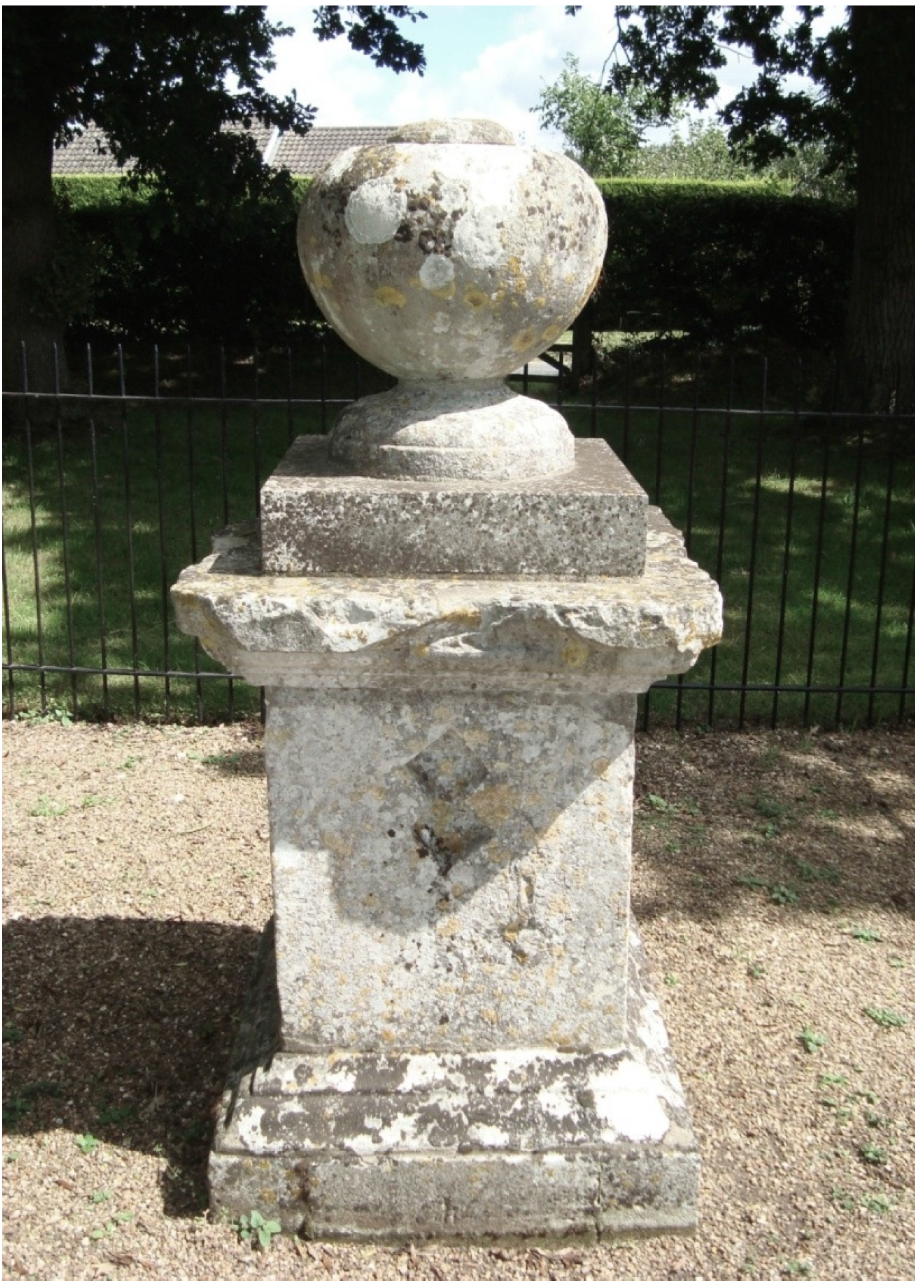
Arriving at the site of the Duel Stone (see
Figure 1), I had no sense of having found anything of great significance, but there was nevertheless some relief in having found the site before midday and a sense of anticipation, as this was the point from which my journey would begin. It was slightly disappointing, though, that nothing struck me as unusual about the place—a place which I had genuinely hoped would be replete with some sort of unfathomable energies. A tortured groan emanated from the hinges of the neglected wooden gate that acted as the barrier between the solitude of the monument and the movement of the city bound road. Walking across unkempt grass, I made my way towards the Duel Stone where I planned to take my bearings, in order to determine the direction of the leyline and therefore my route of passage. However, the compass appeared unable to find north, providing me with different readings at each corner of the monument. Standing away from the leyline’s start point I eventually managed to find my path, heading out through the right hand corner of the monument’s enclosure and into the countryside along a well-forged footpath. The grasses, nettles and weeds had been beaten well into submission along what appeared to be a frequently used course of movement. I had begun to map “deeply”, navigating a route by studying, moving, and sensing my surroundings, by noticing the way a path “unfolded” before me.
Figure 1.
The Duel Stone, a small stone sculpture commemorating the death of Sir Henry Hobart following a duel at nearby Cawston Heath in 1698 (Image source: taken by author).
Figure 1.
The Duel Stone, a small stone sculpture commemorating the death of Sir Henry Hobart following a duel at nearby Cawston Heath in 1698 (Image source: taken by author).
This initial encounter with the stone, as something capable of influencing my experience of the site, had proved a little unnerving. I later decided that it was most likely the magnetism of the stone that had interfered with the compass reading, but even if this was the case, could there be a better beginning to a journey that was endeavouring to embed the traveller within a landscape of uncanny material agency?
The Duel Stone itself, a grey tombstone-like monument, was enclosed behind iron railings and was that day set within a backdrop of clouded skies and endless fields, straddled by trees at either side. It occurred to me that the stone, having impeded upon the action of the compass, might be far more strange than I had first thought; there was the small matter of the monument being guarded not just by the railing, but also by the trees and the perimeter fencing. It occurred to me that a lot of trouble had been spent guarding something that people would seldom come across, let alone wish to damage in any way. I let my mind wander to the reasons for taking such protective measures as I headed toward the back of the enclosure and out onto the footpath leading across the field.
Following the path in a northwest direction, away from Cawston and the Duel Stone, I headed through the tree-lined fields where my path was already laid before me. I took this pre-existence of the route as another one of Watkins’ confirmation points; “When at least half-a-mile of road or track of ancient name aligns on a ley, it has value” ([
26], p. 90). This particular section of path corresponded with the area where the ley was supposed to be and, having led directly from a significantly old monument, I took this as evidence of something more “substantial” than what had initially appeared to be just a pathway. As Watkins’ instructions had suggested, the path did take me across a number of small ponds, long straight roads and old, if not ancient, trees. Of greater importance was the manner in which the track composed my views: in fact at the point of reaching Salle, the second village along the ley from Cawston, the once surrounding woodland gave way to open fields and extensive vistas across the countryside. This provided me with enough of a view to see at least as far as the next three villages along the leyline and moreover, their churches, which appeared to have been built in alignment with that of my previous destination and the Duel Stone before it. If one was to follow the theoretical trajectory of settlements or sacred sites being built to a specific geometric pattern, then this had offered some affirmation. Furthermore, it brought to mind the idea that these sacred sites were connected, navigable and sited as positions to walk between as a network rather than independently.
The sightlines gained from Salle did as much to reaffirm this sense of connection as Salle’s church itself. Seemingly disproportionate in scale for such a modestly sized parish, The Church of St. Peter and St. Paul loomed over the deserted village green, a structure of gigantic proportions. The building appeared out of place for a settlement so small, with a population of noticeably few residents. Furthermore, a beacon stood in the church’s shadow. For Watkins, beacons were yet another indicator of an ancient track way. The ley had begun to pick up strength in its ability to affect my perception of the landscape; I was being coerced into the networked lineation of churches and trees in order to see their connection, not just to each other but also to the straight pathway that lay before me; a complete experience was emerging from the landscape. The walking of the line was allowing me to notice, to observe (and record) the “grain” of the landscape [
1]. The meshing of history, sacrality and nature into a single straight line was overwhelming. The ley was beginning to make “sense” and I felt that like Watkins, I too was starting to see the relationality between place and to see landscape with new eyes.
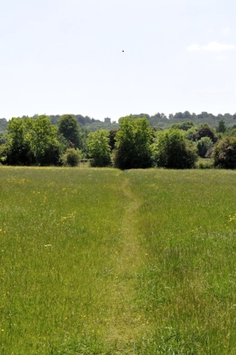
Continuing along the route towards Wood Dalling, I passed a ringed moat to the side of a field; yet another possible Watkinsian confirmation marker. The next field I came to was being sprayed with pesticide, the land to each side was fenced off. I was forced to head back and join the road, which I followed until the next destination, Craymere Beck via Hindolveston. At times the road itself began to take the form of a straight track, reaching almost a mile of undisturbed length in either direction at points (see
Figure 2). Again, this worked to confirm the path of a Watkinsian ley; Watkins considered straight roads to be an evolution of an original alignment, a continuation of the ancient track way in the modern world [
40].
Figure 2.
Watkins claimed that straight roads were an indicator of the evolution of an existing leyline (Image source: taken by author).
Figure 2.
Watkins claimed that straight roads were an indicator of the evolution of an existing leyline (Image source: taken by author).
Again, the straight road that led to Craymere Beck was significant not simply because it followed the ley in a direct and more or less faithful manner, but because of the impact it had upon me as a walker. The tree-lined road produced a tunnelled vision of the landscape before me. Having no option but to walk straight along the path ahead, my surroundings forced vistas upon me; the unfolding environment appeared to have brought me its own horizon. Being coerced to follow the pathway ahead only amplified the earlier feelings that the materialities around me were being set to work somehow. Like the Duel Stone, the place itself was inflecting my vision of the landscape, or at least manipulating it. I could only follow the road in one direction or the other and so my perception of the environment was being shaped for me.
Having been forced onto the road by the spraying of the fields took me to a further point along the leyline than I had thought, although missing out on the experience of having remained faithful to the route in its entirety, the trajectory of the tarmac I ended up on only re-emphasised the encounter as one of a deep connection with my surroundings. The seemingly mundane had begun to speak to me; trees, road names, pathways and churches all provided an alternative understanding of site and of mobility, working together to form a biography of place—a narrative, both real and imagined. The leyline, or rather my embodiment of it, had become “emplaced”; the site(s) became a point of “human experience, constructed in movement, memory, encounter and association” ([
49], p. 15). The perambulation of this route had seen me become thoroughly immersed in and along the ley-place.
The walk continued into the late afternoon. The line passed through another two villages before completing its course at Thursford. Both of these villages contained churches that appeared to be in correlation with the leyline. On completion, the walk seemed to have passed by with an uncanny speed, notwithstanding the impact that the first-hand experience of how sites could be connected to each other through Watkins’ alignments had made upon my understanding of placial relationality.
The leyline may not have been enchanted in any truly mystical sense of the term but there had certainly been moments, if not an overall sense, of something beyond the normative, a deeper connection with place. The demarcations of normalcy and the vernacular had been shifted, what had essentially been a thoroughly researched and lengthy ramble through the Norfolk countryside had resulted in new kind of appreciation for geomantic readings of place and space. Tracking the leyline had allowed me to enter the landscape as a place “sedimented in (both) history and sentiment” ([
49], p. 38). There remains a sense that the walk that day has opened up a different way of knowing place and moreover, the connections between places.
Furthermore, the way that the path had produced predisposed vistas and seemingly pre-empted the composing of the body, suggested something more than Watkins’ evidence of a prehistoric track way; it pointed to the potential for a far more embodied experience of the landscape. This was a type of embodiment that could be explored further through those more esoteric readings of leys seen in the works of Michell [
30] and Cope [
42] In such a light, it stood to reason that there were perhaps other ways of exploring the leyline in my research, means by which practices other than walking alone might be employed to access the vital materiality of place and which might be of a far more extraordinary trajectory.


